HISTORY OF CONSTRUCTION FOR EXISTING CCR SURFACE IMPOUNDMENT PLANT MCMANUS ASH POND A (AP-1) 40 CFR (c)(1)(i)-(xii)
|
|
|
- Scott Daniel
- 5 years ago
- Views:
Transcription
1 HISTORY OF CONSTRUCTION FOR EXISTING CCR SURFACE IMPOUNDMENT PLANT MCMANUS ASH POND A (AP-1) 40 CFR (c)(1)(i)-(xii) (i) Site Name and Ownership Information: Site Name: Site Location: Site Address: Owner: Address: CCR Impoundment Name: NID ID: Clifford B. McManus Power Plant Brunswick, Georgia One Crispen Island Drive Brunswick, GA Georgia Power Company 241 Ralph McGill Boulevard Atlanta, GA Plant McManus Ash Pond A (AP-1) NA EPA s Disposal of Coal Combustion Residuals from Electric Utilities Final Rule (40 C.F.R. Part 257 and Part 261), (c)(1), requires the owner or operator of an existing CCR surface impoundment to compile a history of construction. To the extent feasible, the following information is provided: (ii) Location of CCR Unit: N , W See Location Map in the Appendix (iii) Purpose of CCR Impoundment: The Clifford B. McManus Power Plant (Plant McManus) was once a two-unit power generation facility. Construction of Unit 1 began in 1951 and the initial startup and commercial operation began in November Unit 1 was originally designed to operate as an oil-fired generator. Construction on Unit 2 began in 1957 and was declared commercial in Unit 2 was originally designed with coal as the primary fuel. Unit 1 was converted to coal in In 1971, both Units 1 and 2 were converted to oil-fired and the use of coal ceased after In 1972, nine (9) diesel-fired simple cycle combustion turbines were installed and which currently operate. Units 1 and 2 have been retired and demolished as of AP-1 was designed to receive and store coal combustion residuals and process water produced by Units 1 and 2 during the electric power generating process at Plant McManus. AP-1 has not received ash since the early 1970 s.
2 (iv) Watershed Description: Plant McManus and AP-1 are located within the Turtle River South Brunswick River HUC 12 watershed which has a total area of 51,891 acres. The Turtle River South Brunswick River watershed is part of the larger Cumberland-St. Simons HUC 8 watershed which has an area of 609,980 acres. The inflow into AP-1 consists of the rainfall that falls within the limits of the surface impoundment and runoff from the adjoining 68-acre watershed. (v) Description of physical and engineering properties of CCR impoundment foundation/abutments: AP-1 is located in the Barrier Island sequence of the Coastal Plain physiographic province. The Barrier Island sequence is characterized by its marshes and sea islands. According to the Geologic Map of Georgia, 1976, Plant McManus is located in the Southeast Georgia Embayment, a depositional basin formed during the subsidence of the continental margin and episodic rise and fall of sea levels. The area has unconsolidated and semi-consolidated sedimentary rocks. These sedimentary rocks are Cretaceous age and younger and are comprised of two facies: clastic sediments with minor limestone components and shallow-water platform carbonate units. (vi) Summary of Site Preparation and Construction Activities: AP-1 was constructed in 1957 by Georgia Power Company by placing a dike embankment across an upland marsh area north of the plant s main access road. The pond was constructed in parallel with Unit 2. Unit 2, unlike dual fuel rated Unit 1, was designed with coal as its primary fuel. Units 1 and 2 were converted to #6 fuel oil in 1971 and 1972, respectively. AP-1 did not receive CCR after 1972 but continued to support plant operations with low volume waste treatment. The Plant McManus AP-1 is in the process of being closed through removal of the CCR from the CCR unit. As of March 2018, approximately 60% of the CCR has been removed. AP-1 is dewatered as required to facilitate excavation of ash for removal. All CCR is being excavated, transported, and disposed of in an offsite Solid Waste permitted landfill. Closure is anticipated to be completed 4 th Quarter The pond dike and primary spillway are intact and continue to impound water. During ash pond closure, accumulated water is managed by a temporary water treatment system in accordance with a dewatering plan approved by the Georgia Environmental Protection Division. The treated water is then discharged via the NPDES permitted outfall located at the westernmost corner of AP-1. When discharged, the treated water is sampled and monitored in accordance with the approved dewatering plan. Drawings showing the topography and location of AP-1 are included in the appendix as engineering diagrams.
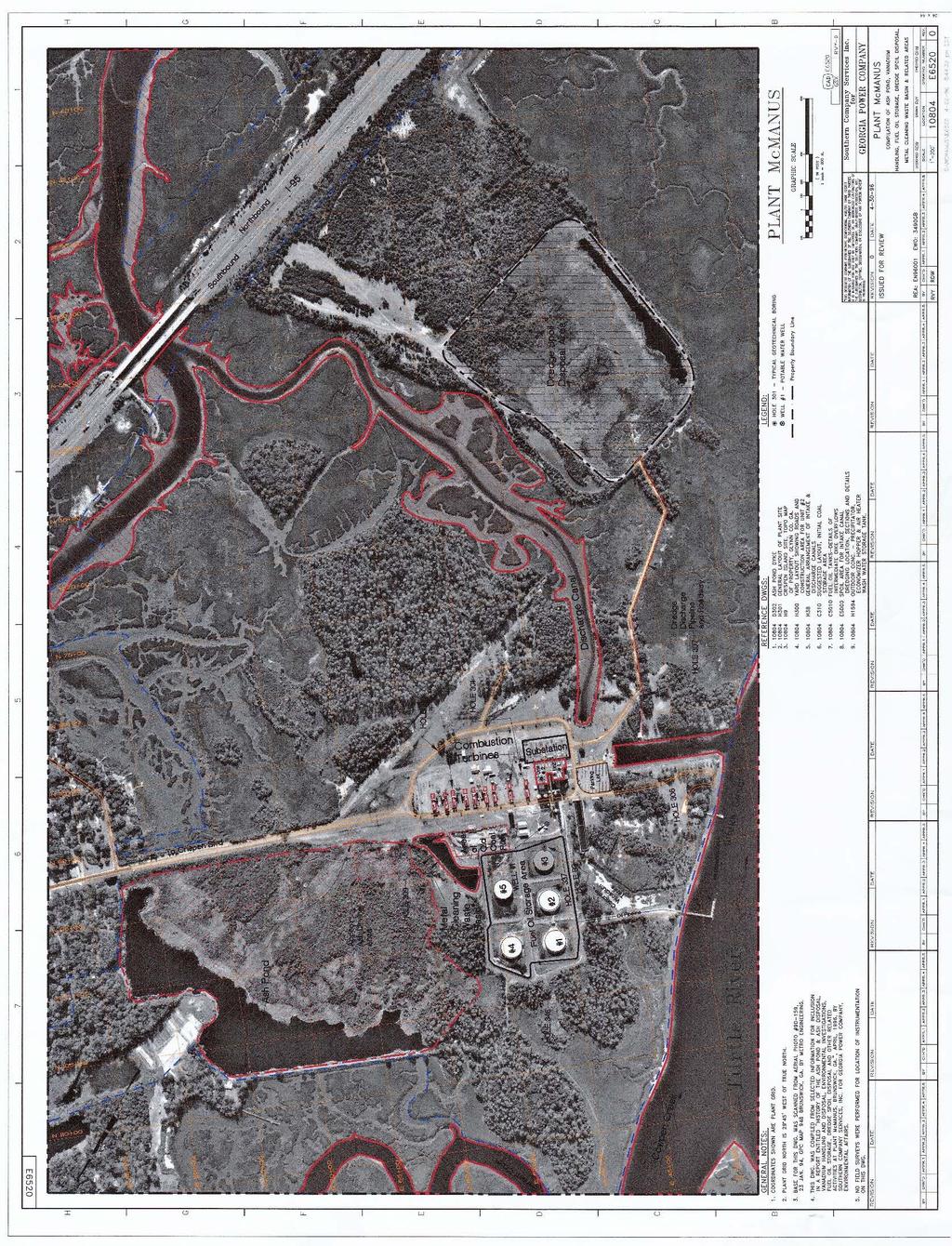
3 (vii) Engineering Diagram: The following drawings relevant to the location and topography of Plant McManus AP-1 can be found in Appendix A: 1976 USGS Topography Map ATC Site Map November 1996 Plant McManus Ash Pond Spillway Repair drawing C68 dated May 1979 Plant McManus Ash Pond Dike Construction drawing D-302 dated April 1957 Plant McManus Site Aerial Photo and Map drawing E6520 dated April 1996 (viii) Description of Instrumentation: There is no instrumentation at AP-1. (ix) Area-capacity curves: See Appendix B for Stage Storage Curve (x) Spillway/Diversion design features and capacity calculations: The impoundment was designed and constructed to use a primary discharge spillway in the westernmost pond corner. The spillway consists of a rectangular (4 feet tall by 8 feet wide) concrete channel with a 120 V -notch weir and discharges into Burnette Creek, a brackish water tributary of the Turtle River. Evaluation of the capacity of the entire ash pond site indicates that runoff from a 1000-year, 24-hour storm event can be completely stored within the Ash Pond. Capacity calculations were based on topographic and bathymetric survey information performed in January Based on the 1000-year flood routing, the peak outflow discharge is 4.88 cubic feet per second at a peak water surface elevation of 5.88 feet leaving a freeboard of 0.12 feet. Normal pool is 3.00 feet (Mean Sea Level). (xi) Provisions for surveillance, maintenance and repair: Inspections of dikes are critical components and are conducted on a regular basis at least annually by professional dam safety engineers and at least every 7 days by trained plant personnel. In addition, inspections are performed after significant events such as storms. The inspections provide assurance that the structures are sound and that action is taken, as needed, based on the findings. Safety inspections include numerous checklist items. Specific items vary from site to site but may include observations of such things as pond levels, weather conditions, rainfall since the prior inspection, conditions of slopes and drains, erosion, animal damage, ant hills and more. Dam safety engineers inspect any maintenance or remediation performed since the previous inspection, check the status of work recommended at prior inspections, ensure that emergency notification information is current and evaluate any items noted during plant personnel inspections. (xii) Known record of structural instability: There are no known instances of structural instability at the CCR unit.

4 Appendix A Plant McManus Ash Pond USGS Topo
5
6
7
8
9 Appendix B
10