Dry Creek Flood Control Improvement Project
|
|
|
- Damon Dawson
- 5 years ago
- Views:
Transcription
1 Dry Creek Flood Control Improvement Project The following is a brief overview of the planned IRWM Stormwater Flood Management Grant Application from the Fresno Metropolitan Flood Control District (FMFCD) intended for discussion with DWR staff regarding the flood damage reduction benefits. Background: The Fresno Metropolitan Flood Control District (FMFCD) is responsible for storm and flood water management for the greater Fresno/Clovis area extending to the foothills to the east. FMFCD has a very complex flood control system that must handle storm waters from a series of stream channels (Fresno County Stream Group) that drain through the urban area. These streams carry runoff from a 190 square mile area that reaches an elevation of 5,000 feet in the Sierra-Nevada. In addition, the facilities must handle storm waters from within the urban area. The Fresno area is unique such that there are no natural drainages that leave the area without first filling the area historically known as the Sinks of Dry Creek. The Sinks of Dry Creek is now urbanized. Without a natural drainage and limited capacity to discharge water in man-made channels, the system is dependent on the capacity of a number of basins to detain water from the rural streams and urban area. These urban basins have limited storage capacity and must be de-watered to handle more significant flood events. To dewater the basins, the system relies on the use of local irrigation canals to convey the water through the urban area. These same canals are utilized to route the rural stream runoff through the urban area. FMFCD has an agreement with the Fresno Irrigation District to use their canal system for flood water conveyance, but their system has capacity limitations and discharges to it must be managed very carefully to avoid flooding outside of the canals. Essentially, the limitation to flood protection in the urban area is a function of the storage capacity available to attenuate peak flood flows. Incidentally, additional storage is also a significant need to improve the conservation and recharge of the local water supply and reduce the groundwater overdraft. FMFCD utilizes a flood routing model created by the USACE in the 1990s to plan its flood routing and flood protection systems. The model was intended to safely route the 200-year flood event through the urban area with the complex integrated detention of stream and urban runoff to prevent exceedance of the relief conveyance through the irrigation canal system. FMFCD has been working to develop the improvements required to manage the 200-year flood. Project Description: The Stormwater Flood Management Grant funds will be used to improve the safety of the Dry Creek Dam and increase the storage capacity along the Dry Creek system for (3) other facilities, thereby improving the capacity of the system to manage a more
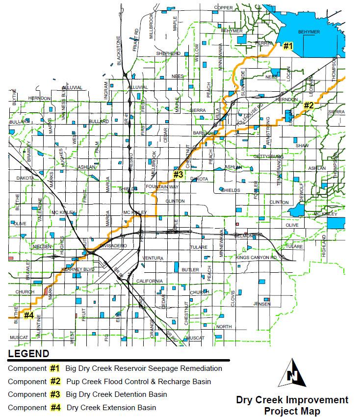
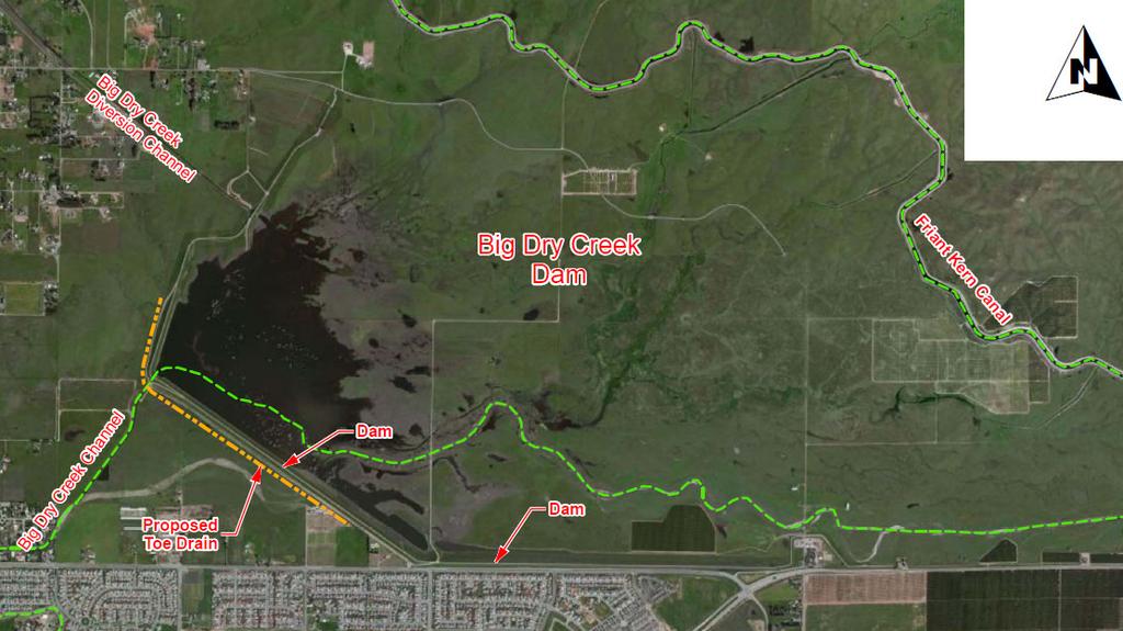
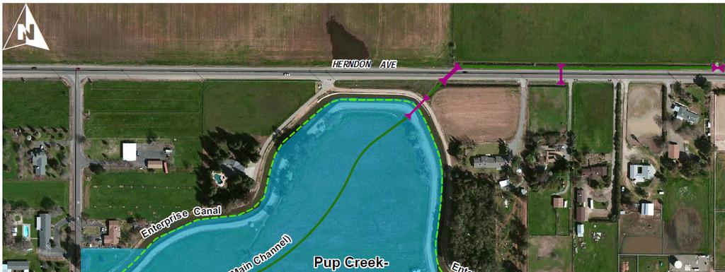
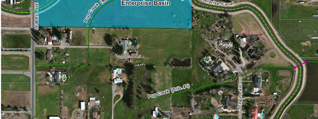
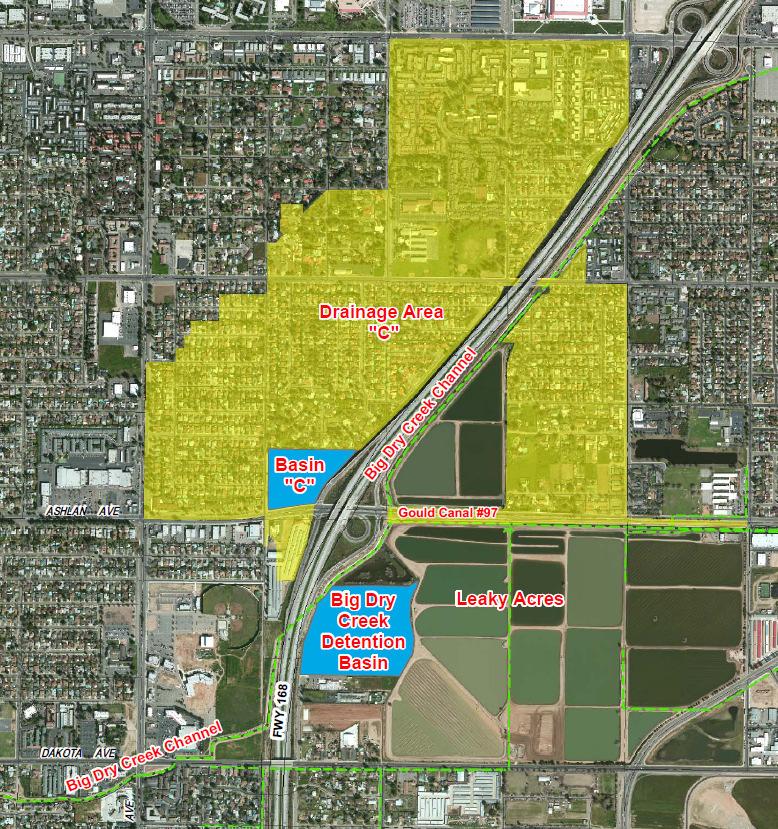
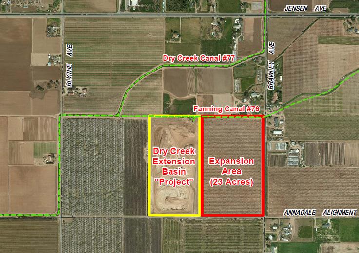
2 significant flood event. The project is part of the overall system improvements for the routing of the 200-year storm event. The four components of the project include: Big Dry Creek Reservoir Dam Toe Drain: Constructing a deep toe drain on the downstream side of the Big Dry Creek Reservoir Dam. Although intended to sustain a standard flood pool of 30,300 acre-feet at a storage pool elevation of 432.7, sustained seepage and sand boils have been observed at the toe of the dam when the elevation reached the maximum water historically stored behind the dam. A toe drain is proposed to protect the dam from failure and allow water to be more safely stored up to the 200-yr event level of Pup Creek Enterprise Detention Basin: Acquisition of land and the initial construction of a basin levee and culverts crossing the Enterprise Canal will help prevent additional water from spilling into the Enterprise Canal. The conveyance capacity in the Enterprise Canal is already reserved for other flows, including diversion of upstream flows that are routed to the Big Dry Creek channel; Acquisition of land and the connection of the Big Dry Creek Detention Basin to the Big Dry Creek channel: A 25-acre basin site, with approximately 260 acrefeet of storage capacity, is being developed adjacent to the Big Dry Creek channel and at the terminus of the Gould Canal. Facilities to move water into and out of this facility from Dry Creek are needed. A new turnout, pump relief system and other basin improvements will allow for the basin to provide conveyance capacity relief to the channel as well as additional urban area storm water relief. Acquisition and improvement of the Dry Creek Extension Basin: The District recently acquired a 20 acre parcel and material is being removed to create storage. Grant funds are needed for all development of the property into a functional detention basin other than excavation, as the District has the ability to obtain material export. The District also has an opportunity to acquire an additional 23-acre expansion of this basin. The current 20 acre site will store approximately 316 acre-feet and with the 23-acre expansion increase to 795 acre-feet of storage capacity. The grant funds will greatly assist the District s ability to develop the property to a functional basin The ability to improve the flood routing system upstream of this location is restricted by the flow capacity downstream of the Dry Creek Extension Basin. Currently substantial improvements are needed to the Dry Creek Extension Basin, as it is not yet connection to Dry Creek and the Fanning Ditch, the connections to permit the basin to function as control feature for Dry Creek flows. Flood Damage Reduction Benefits: Flood damage reduction for Big Dry Creek Dam improvements will include preventing a dam failure, which is assumed to occur at the maximum water level based on the observed seepage and boils at much lower water levels. The flood damage will be based on a dam break inundation map created by the US Army Corps of Engineers in the 1990 s. Further, risk of dam failure from seepage and boils may likely require the
3 full opening and release of floodwaters to downstream channels and cause major flood damages before developing the full capacity of the reservoir. Flood damage reduction from the stormwater basins will be achieved by reducing the flood damage around urban basins needed to be dewatered. The primary problem within the region is limited conveyance capacity to safely route rural streams and urban runoff through the metropolitan area. During significant events, the conveyance system requires additional downstream storage capacity to be able to accept additional urban basin dewatering pumping. Providing additional storage for the water in the conveyance system to be delivered will allow for urban basins to be dewatered during significant events and reduce the potential for flooding around those basins needing dewatering. Each of the features of the grant project can reduce the peak flood flows throughout the system. The plan for considering flood damage reduction benefits for the stormwater basins is the following: 1. Identify total urban water dewatering pumping capacity needed. 2. Identify conveyance capacity limitations. 3. Identify storm event when urban water dewater pumping capacity exceeds available conveyance capacity. 4. Identify basins most likely to not be dewatered during periods of limited conveyance capacity and their respective pumping rate and duration. 5. Estimate basin flooding area based on pumping rate and duration needed to dewater. 6. Determine flood inundation area from volume estimated above. 7. Identify total storage volume capacity at each proposed basin included in this project. 8. Correlate additional storage volume to pumping dewatering flowrate and duration for specified year event at existing basins not able to be dewatered as identified in #4.
4
5
6
7
8