Blairadam Forest Wind Farm. Non-Technical Summary
|
|
|
- Victor Wade
- 5 years ago
- Views:
Transcription


1 Blairadam Forest Wind Farm Non-Technical Summary January 2014
2 Non Technical Summary Context This Non Technical Summary (NTS) forms part of the Environmental Statement (ES) that has been prepared by SKM Enviros on behalf of Partnerships for Renewables (PfR) to accompany a planning application to construct and operate a wind farm development at Blairadam Forest situated to the south and south-east of the Cleish Hills in Fife, located approximately 6 km north of Dunfermline and 3 km to the west of Kelty. The proposed wind farm has been developed in partnership with Forestry Commission Scotland (FCS). The ES presents the findings of an Environmental Impact Assessment (EIA) and is designed to identify potentially significant effects from the proposed development, and where appropriate, to propose suitable mitigation measures to address or minimise any effects identified. This document is a non technical summary of the main findings of the ES. Background The Intergovernmental Panel on Climate Change (IPCC), which is the principal scientific body advising governments on climate change, has confirmed the significant influence on the global climate of increases in atmospheric levels of carbon dioxide (CO 2 ) and other greenhouse gases as a result of human activities. The burning of fossil fuels (such as coal and gas), to generate electricity is a major source of greenhouse gas emissions. A vital part of reducing these emissions is increasing the proportion of electricity generated from renewable energy sources, such as wind. The Climate Change (Scotland) Act 2009 sets a legally binding target of at least an 80% cut in UK greenhouse gas emissions by 2050 compared with 1990 levels, with an interim target also requiring emissions to be at least 42% lower by 2020 compared with 1990 levels. In order to meet these climate change targets, as well as to provide greater energy security and meet rising energy demands, the Scottish Government has set a target requiring that 100% of Scotland s gross annual electricity consumption be generated from renewable sources by This 100% renewables target roughly equates to approximately 14 to 16 gigawatts (GW) of installed capacity over the next 7 years (compared to about 4.8 GW installed today) and is the most ambitious renewables target in Europe. If these ambitious targets are to be met, the Scottish Government recognises that more renewable energy developments will be required, in particular onshore wind energy developments given that this is accepted as the most efficient and competitive renewable technology in the short to medium term. As such, the proposed eleven wind turbines at Blairadam Forest would make a positive and valuable contribution towards achieving these goals. Developer and Project Team PfR has been working in partnership with FCS since 2009 to develop the wind power potential of the National Forest Estate (NFE) within the Scottish Lowlands and Scottish Borders. PfR was established by the Carbon Trust in 2007 to develop, construct and operate renewable energy projects primarily on public sector land. PfR manages the development of projects through site selection, assessment of site feasibility, layout design process, construction and operation. FCS serves as the forestry directorate of the Scottish Government and, through its operating arm Forest Enterprise Scotland (FES), is responsible for managing the NFE on behalf of Scottish Ministers. The NFE is the largest single public land resource held by the Scottish Government, comprising over 660,000 Ha of land, and provides an extremely valuable resource to demonstrate how the Scottish Government can maximise the contribution of forestry to society whilst continually improving and exploring new solutions to challenges such as climate change. Given the huge scale of the NFE, FCS has set a target of having 2 GW of renewable energy capacity installed on the NFE by The EIA has been managed and co-ordinated by SKM Enviros on behalf of PfR. SKM Enviros is a leading environmental consultancy providing water, environmental, sustainability and health and safety solutions to its clients across the United Kingdom and globally. SKM Enviros is a Registered Environmental Impact Assessor and has achieved the Institute of Environmental Management and Assessment (IEMA) EIA Quality Mark Standard. IEMA is a leading international organisation dedicated to the promotion of sustainable development and the promotion of best practice standards in environmental assessment and management. Further specialist input to the EIA came from Hoare Lea Acoustics who undertook the noise assessment, RPS who undertook the cultural heritage assessment and RSK who undertook the landscape and visual impact assessment. All other assessments were completed by SKM Enviros. The Development Proposals The proposed wind farm will comprise eleven wind turbines and associated infrastructure and although the final choice of turbine for this site will depend on which turbine models Section continues overleaf > 1
3 The Development Proposals continued > Blairadam Forest Wind Farm Number of Wind Turbines: 11 Maximum Tip Height (combined height of blade and tower): 115 m Estimated Total Generation Capacity: MW Estimated Capacity Factor: 27.9%* Estimated Electricity Generated Per Annum: 55.1 GWh Households Equivalent: 12,900 Estimated CO 2 Savings: 23,700-25,600 tonnes of CO 2 per year Please note that the environmental benefit figures are based upon 11 x 2.05 MW with a total installed capacity of MW, operating with a 27.9% capacity factor*, average household electricity use of 4,266 kwh per annum, and the electricity generated displacing electricity from CCGT (0.43 kgco2/kwh) or the 5 year average fuel mix (0.465 kgco2/kwh). *The capacity factor used is the average for Scotland (2000 to 2012). The actual site specific capacity factor should be higher (estimated at 30.9%). Therefore the actual electrical output, carbon savings and households supplied are likely to be slightly better than these figures suggest. are available in the UK market and the outcome of a competitive tendering exercise, the site has been designed to accommodate turbines of up to 2.5 MW. The installed capacity of each turbine will therefore be between MW. The EIA has been based on a candidate turbine of 2.05 MW capacity giving a site capacity of MW. Assuming an installed capacity of MW (11 x 2.05 MW) the proposed development could generate 55.1 GWh of renewable electricity per year. This is equivalent to the amount of electricity used annually by approximately 12,900 average households in Britain (or about 7% of the Fife households) and is expected to displace between 23,700 and 25,600 tonnes of CO 2 equivalent emissions per year, depending on the grid factor used in the calculation. The selected turbine would have three blades, each approximately 45 m in length. The blades would be mounted to the wind turbine nacelle, at a height of approximately 70 m supported on a tapering cylindrical steel tower, thus giving a maximum height to vertical blade tip of a maximum of 115 m. The proposed wind farm will be connected into the local distribution system. Analysis and discussions with the local Distribution Network Operator (DNO), Scottish Power Energy Networks, indicate that the wind turbine is likely to feed electricity into the grid via a 33 kv underground cable to the Dunfermline Grid Supply Point (Dunfermline GSP), to the south. The expected connection route would follow the A823 and local roads into the substation and control building compound. The works comprising the grid connection are not included in this application; the enabling works will be undertaken by the DNO, Scottish Power Energy Networks, as a statutory undertaker. The integration of wind turbines to the western block of Blairadam Forest requires alterations in the long term planned management regime which is represented by the current approved (by Central Scotland Conservancy) Forest Design Plan (FDP) The effects on current and planned forestry practices brought about by the project are described within Chapter 4 and Technical Appendix 4.2 of the ES. The current FDP is reproduced at Appendix 4.1 in the ES. Forestry felling in the area will occur in two distinct phases; the first round of felling will occur during the pre-construction phase of the wind farm. The felling will occur within the application site boundary and will follow a keyhole felling strategy. As described in Chapter 4 Section 4.3 and shown in Appendix 4.2 Figure 4.2.2, the initial forestry clearance operations will be limited to the buffer zone around turbines and essential infrastructure including crane hardstandings, substation and control building compound and access tracks. The second phase of forestry felling will occur during the operational lifetime of the proposed wind farm, within the development site boundary. Separate approval by FCS Central Scotland Conservancy will be required for an amended Forest Design Plan which will also secure the restocking of the forest. In accordance with the Scottish Government s policy on the Control of Woodland Removal, PfR is committed to replacing permanent woodland loss. PfR will submit a Compensatory Planting Plan for approval to FCS Central Scotland Conservancy prior to the commencement of construction. The construction period for the proposed wind farm is estimated to take approximately 20 months inclusive of felling the trees within the development site. Subject to achieving planning permission, it is anticipated that the construction works would not begin before
4 Figures are attached at the end of this NTS showing the Site Location plan (NTS Figure 1) and the proposed Site Layout (NTS Figure 2). A diagram of the candidate turbine is also included in NTS Figure 3. Site Description The planning application site boundary is shown outlined in red in NTS Figure 2 whilst the western block of Blairadam Forest is defined by the blue line and referred to as the development site. The application site, approximately 40 Ha in area, is located within an area of commercial forestry, the western part of Blairadam Forest which covers an estimated area of 492 Ha. The forest is owned by Scottish Ministers and operated by FCS and is situated to the south and south east of the Cleish Hills in Fife, approximately 6 km north of Dunfermline and approximately 3 km to the west of Kelty. The application site lies wholly within the jurisdiction of Fife Council. The Perth and Kinross Council area lies adjacent to northern boundary of Blairadam Forest, an estimated 600 m from the proposed application site. The development site is gently undulating and generally slopes towards the east and the south. The elevation of both the development site and the application site is approximately 200 m to 300 m above ordnance datum (AoD). To the east of the development site is the Blairadam Estate and the eastern half of the Blairadam Forest, with the B914 running west of the development site from Kelty to the south. To the west runs the A823, while the heights of the Cleish Hills and Loch Glow lie to the north. Loch Leven is situated approximately 4 km to the northeast of the development site, separated from the forest by the M90 which lies approximately 2.5 km to the east of the development site. The Knockhill motor racing circuit is located to the immediate west of the development site. Blairadam Forest is a FCS conifer plantation managed on behalf of the Scottish Ministers. The plantation is comprised of generally even aged stands of Spruce mixed with other pines. The approved Blairadam FDP 2012 depicts how the forest is planned to undergo a restructuring as the crop reaches maturity with the introduction of greater species diversity, smaller coupes and a greater amount of open space. Neither of the development site or proposed application site are subject to any international or national designations, with the exception of Muckersies Knowe which is a designated heritage asset within the boundaries of the development site. There are 21 statutory nature conservation sites within 10 km of the application site, in addition to, a number of local wildlife sites (LWS) within the vicinity of the application site; two of which are hydrological linkage to the application site, namely Roscobie Reservoir LWS (300 m south at its closest point) and Loch Fitty LWS (1.8 km southwest) downstream of Roscobie reservoir. A number of residential properties in the vicinity of the development site have been selected as being representative of the closest located properties to the wind farm. The minimum separation distance between the nearest turbine and the closest located property, the Uniter Building (a derelict building within a former Ministry of Defence installation, with planning permission to be converted to a residence) is approximately 770 m, and the closest occupied residential property Wester Deanhead is approximately 818 m. Site Selection and Design Evolution A screening assessment of the potential for wind development throughout the two Forest District s land portfolios was conducted and focused upon issues including land availability, existing land use, presence of any international or national environmental or planning designations, wind resource, electricity grid connection, transport infrastructure, distance from residential properties and potential visual impact. The conclusion of the assessment was that Blairadam Forest was identified as having good potential to support a medium to large wind energy development. The design of the Blairadam Forest Wind Farm has incorporated a new partnership design process between the Applicant (PfR) and FCS (Forest Enterprise Scottish Lowlands Forest District). The objective of the partnership was to successfully integrate the development into the existing forest operations, maximising the potential of both renewable energy generation and the net public benefits that the forest offers. Design briefs were developed for both the turbines and forest. Design workshops were then held to optimise the environmental, economic and public benefits of the proposals using feedback from baseline research, consultation and surveys. This was followed by groundtruthing and on-site optimisation of the layout through micrositing of turbines and tracks together with re-assessment (including further surveys where necessary). Using this approach the site has evolved through three stages: Feasibility - where it was considered that the site could potentially support up to 23 turbines, later scaled back to 17; Scoping - where it was considered that the site could potentially support up to 14 turbines. The reduced number of turbines was based on the results of an optimisation study, focussing upon landscape and visual impact considerations and other early development studies; and Section continues overleaf > 3
5 Site Selection and Design Evolution continued > Final proposed layout - which comprises 11 turbines. The layout seeks to show the optimal scheme for the site, resolving the differing technical and environmental priorities on site inclusive of continued compliance with the UK Forest Standard. The final layout inclusive of proposals to amend the approved Blairadam Forest FDP is the conclusion of the above steps and seeks to maximise the benefits of renewable energy generation and avoid or minimise the effects to the forest and surrounding environment. Environmental Impact Assessment (EIA) EIA is a process that collects information about potential environmental effects of a proposed development and evaluates and presents this information in a way that both assists consultation and enables decision makers to take account of these effects when determining whether or not a project should proceed. If the project does proceed, the EIA also helps identify any mitigation measures or controls over the construction or operation that might be required. The content and scope of the EIA for the proposed Blairadam Forest Wind Farm was agreed through a scoping exercise in January 2012 with Fife Council. The EIA has identified the likely effects of the proposed development on the environment and an assessment has been made as to whether any of these could be significant. In general terms, establishing whether an identified effect is significant is determined by the importance of the receptor (e.g. a particular listed building, ecological designated site or landscape character area) and the magnitude of change that will occur as a result of the construction, operation and decommissioning of the turbines which in turn, establishes the significance of effect. Chapter 2 of the ES sets out the EIA methodology employed in more detail. A number of mitigation measures to reduce potentially significant effects have been incorporated into the design of the proposed development. Additional measures will be set out in an Environmental Management Plan (EMP) to be implemented during the construction and operation of the wind turbines. The ES reports the findings of the EIA, which has been prepared in accordance with The Town and Country Planning (Environmental Impact Assessment) (Scotland) Regulations The ES comprises this NTS and three volumes: Volume 1 Written Statement, Volume 2 Figures and Volume 3 Appendices. The assessment of effects is undertaken in an impartial manner with the findings presented systematically in the ES, which will be used by Fife Council to help inform its decision about whether or not the proposed Blairadam Forest Wind Farm should be allowed to proceed. Consultation A vital aspect of the EIA process is consultation, both to agree which environmental topics need most attention (including the scope and methodology of the assessment) and to understand public perception of the development in order to help in the design process. Consultation with statutory and non statutory bodies was undertaken through the submission of an EIA Scoping Report and the request for a formal Scoping Opinion from Fife Council, with responses received from (amongst others) officers within Fife Council, Scottish Natural Heritage (SNH) and SEPA. In addition there has been continued dialogue with relevant statutory and non-statutory consultees both before and after the request for a Scoping Opinion was submitted to Fife Council. The full list of consultees is set out in Chapter 3 of the ES and includes: SEPA, Forestry Commission Scotland Central Scotland Conservancy, Transport Scotland, Fife Council Transportation and Environmental Services, Fife Council Public Protection Team, Fife Council Enterprise, Planning and Protective Services, SNH, Historic Scotland, Perth and Kinross Council and various community councils. PfR has also undertaken extensive discussions with the local community and local landowners. The findings have influenced the design of the proposal. Consultation began at the earliest stage of development to establish feasibility and has progressed through to the planning application submission stage. Four public exhibitions were held as detailed below outlining development proposals and to advise local residents of project progress, in addition to providing opportunities for attendees to discuss and comment on the proposed development. Public exhibition Kelty Community Centre (3.15pm 8.15pm on 3rd December 2012); Public exhibition Cleish Village Hall (2pm 8pm on 5th December 2012); Public exhibition Saline Community Centre (2pm 8pm on 20th May 2013); and Public exhibition Kelty Community Centre (2.30pm 7.30pm on 23rd May 2013). A separate Pre-application Consultation (PAC) Report provides full details of public consultations undertaken, the feedback received and PfR s response to it. This forms part of the planning submission. 4
6 Environmental Effects The scoping exercise identified a range of potential environmental effects. These were subjected to detailed assessments using methodologies specific to the relevant environmental topic. Those considered in this ES are listed as follows: Climate Change Mitigation and Other Atmospheric Emissions Chapter 6; Traffic and Transport - Chapter 7; Noise - Chapter 8; Landscape and Visual - Chapter 9; Cultural Heritage - Chapter 10; Ecology - Chapter 11; Ornithology - Chapter 12; Water Environment and Ground Conditions - Chapter 13; Shadow Flicker - Chapter 14; Socio-economic and other Community Effects - Chapter 15; and Waste Chapter 16. The Environmental Statement The ES, which accompanies the planning application to Fife Council, provides an assessment of identified significant environmental effects resulting from the construction, operation and decommissioning of the proposed Blairadam Forest Wind Farm. Chapters 1 to 3 of the ES describe the EIA and scoping process, the site identification, design process and alternatives considered (i.e. the design evolution). Chapter 4 provides a description of the proposed wind farm development during each of the three phases (construction, operation and decommissioning). Chapters 5 and 6 set out relevant legislation and planning policies with regard to climate change and renewable energy. Chapters 7 to 16 (as listed above under Environmental Effects) assess the predicted environmental impact of the proposed wind farm and set out details of measures that are either built into the design or proposed as additional measures to avoid or reduce any potential negative effects or enhance any potential positive effects. Chapter 17 summarises all relevant environmental management, mitigation and enhancement measures in the ES. The following sections provide a brief, non technical summary of the main findings of the EIA which are described in detail within the individual chapters of the full ES. Climate Change Chapter 6 The assessment of the effects on climate change involved a calculation of the expected carbon savings and losses using the Scottish Government s carbon calculator Calculating carbon savings from wind farms on Scottish peat lands - A New Approach (2012). The results of the carbon calculator for the proposed development show that the development is estimated to produce annual carbon savings between 23,700 and 25,600 tonnes of CO 2 per year through the displacement of grid electricity, depending whether the long-term marginal grid factor or the current average grid factor for all fuels including nuclear and renewables is used to calculate the savings. The assessment of the carbon losses and gains has estimated a total loss of around 71,000 tonnes of CO 2e during the lifetime of the project, mainly due to loss of soil organic matter during the construction of the wind farm, the embodied losses from construction materials and the manufacture and transport of the turbines and provision of backup power to the grid. The results from the carbon calculator are likely to be an overestimate of the losses and an underestimate of the gains. All the forestry felling within the application site has been attributed to the construction of the wind farm, even though the equivalent area of trees will be restocked elsewhere because the compensatory planting plans have yet to be finalised. The peat resource on site has been extensively modified through existing forestry practices (ploughing and drainage) therefore the future of the soil carbon store on site in the absence of the wind farm construction would be uncertain. The estimated payback period of the proposed development, using the Scottish Government methodology, is estimated at 2.8 years, with a minimum/maximum range of 1.9 to 4.3 years. There are no current guidelines about what payback periods constitute a significant impact but 2.8 years is around 11% of the anticipated lifespan of the wind farm. Compared to fossil fuel electricity generation projects, which also produce embodied emissions during the construction phase and significant emissions during operation due to combustion of fossil fuels, this project has a very low carbon footprint. It is estimated that after approximately 2.8 years, the carbon-free electricity generated by Blairadam Forest Wind Farm will have paid back the carbon expended in manufacturing and installing the infrastructure by displacing grid electricity generated from fossil fuel sources. The carbon intensity, which is the GHG emissions per unit of Section continues overleaf > 5
7 Climate Change Chapter 6 continued > electricity generated, of the proposed development is within the range of the carbon intensity of grid electricity required by the Scottish Government to meet the Climate Change Act target in 2050 and therefore the proposed development is evaluated to have an overall positive effect on climate change mitigation. Traffic and Transport Chapter 7 The proposed development has been assessed with reference to Guidelines for the Environmental Assessment of Road Traffic published by the Institute of Environmental Assessment. Consultation has also taken place with Fife Council and Transport Scotland. This assessment considered the traffic generated by the proposed development and resulting impacts, such as severance, accidents and road safety, driver delay, pedestrian amenity and fear and intimidation over the study area. An Abnormal Loads Route Assessment (ALRA) has been undertaken that considers the options for delivering the wind turbine components to the application site and is included as Appendix 7.1 of the ES. It is anticipated that the abnormal loads will travel in a north-west direction from the Port of Rosyth taking the following route: The approved abnormal load route between the Port of Rosyth, Fife and M90 Junction 4; West on the B914; North on the A823; and Proposed site access off the east side of the A823 approximately 1.3 km from junction with the B914. To assess the potential impact of increased traffic along this route, traffic surveys were undertaken on the following roads in order to establish baseline traffic levels: M90; M876; A907; A994; A985; B914; and A823. Vehicles associated with construction of the wind farm will result in increased traffic flows on the above roads leading to the application site. However, when considering actual volumes of traffic, the predicted increase in flows are well within the practical operating capacity of these roads and the environmental effects will not be significant assuming appropriate mitigation measures are implemented. Some modification of existing roads will be required to permit the safe passage of abnormal loads, including road widening and temporary removal of street furniture. A Construction Traffic Management Plan (CTMP) will be prepared prior to construction, outlining appropriate and safe routes for staff and construction vehicles to use to gain access to the site as well as necessary signing. The content will be agreed with Fife Council. The levels of traffic anticipated during the operational phase of the proposed development are not significant in terms of the EIA Regulations. The principal effect of traffic is associated with the construction of the proposed development. These effects are of a temporary nature and are not significant in terms of the EIA Regulations. Noise Chapter 8 Two types of noise are emitted from wind turbines. Aerodynamic noise is produced by the movement of the blades through the air, often characterised as a swish and mechanical noise can come from the components within the turbine itself such as gearboxes and mechanisms to change the direction of the turbine. Recent progress in reducing the noise from turbines has been considerable, particularly in relation to mechanical noise. The noise assessment established the difference between wind turbine noise and the naturally occurring noise level at homes (residential properties) nearest to the proposed development and measured these against levels required by accepted standards and planning guidance. Government guidance for this assessment procedure is called ETSU-R-97, The Assessment and Rating of Noise from Wind Farms and specifies that noise limits should be set relative to existing background noise levels and reflect a variation in wind speeds. In general terms, during the daytime, noise from wind turbines needs to be no more than 5 decibels above existing background noise except where background noise levels are exceptionally quiet, in which case permissible noise from turbines is fixed at between decibels. During the night time, noise from turbines needs to be no more than 43 decibels or 5 decibels above background whichever is the greatest. As set out above, the exact model of the wind turbine for this site will depend on which machines are available in the UK. The noise assessment undertaken in the ES is therefore based on a Repower MM92 2 MW turbine which is typical of the type and size of turbine being considered for this site. As a worst case scenario, the assessment assumes that each receptor location is simultaneously downwind of the wind turbines. The emission levels also incorporated a margin to account for typical measurement uncertainties and the prediction methodology used was in accordance with the Institute of Acoustics Good Practice Guide (GPG). 6
8 It is therefore considered as a worst case analysis. The minimum separation distance between the nearest turbine and the closest property (the currently unoccupied Uniter Building) is approximately 770 metres. The nearest occupied residential property Wester Deanhead is approximately 818 metres from the nearest turbine. The construction noise assessment has determined that associated levels are expected to be audible at various times throughout the construction programme, but remain with acceptable limits such that their temporary effects are considered negligible except for selected short-term activities close to the Uniter Building. The overall noise effects of the proposed development from all construction activities at all receptors is considered to be of slight significance. Whilst decommissioning may involve activities similar to construction, the decommissioning phase would normally involve less intensive activities and would occur over a much shorter period than the construction phase. The decommissioning phase noise impacts are therefore expected to have a negligible effect, which is therefore not significant. Results of the predicted noise levels demonstrate that during the operational phase of the development, noise levels from the wind farm would be below the levels required by Government guidance (ETSU-R-97) at all residential properties and across all wind speeds, both during the daytime and at night. Predicted cumulative operational noise levels, including the proposed Outh Muir site to the west of Blairadam Forest, marginally exceeded the derived ETSU-R-97 criteria. If both sites were consented, cumulative noise levels could therefore potentially represent a significant impact, unless suitable individual partial noise limits were agreed for both the Blairadam Forest Development and the Outh Muir scheme. In summary, the overall levels of construction noise are considered to represent a negligible effect, and therefore considered not significant in EIA terms. At some locations under some wind conditions and for a certain proportion of the time, the wind farm noise may be audible; however, operational noise immission levels are acceptable in terms of the guidance commended by planning policy for the assessment of wind farm noise, and therefore considered not significant in EIA terms. Similarly, if the planned turbines at Outh Muir become operational, the cumulative noise levels could be made acceptable subject to suitable controls, such as turbine curtailment under specific conditions. Landscape and Visual Chapter 9 The objective of the landscape and visual impact assessment (LVIA) is to determine the effects of the proposed development on the existing landscape resource and visual amenity. The assessment considers the effects of proposed development on: Landscape character areas (identifiable areas with a distinct, recognisable and consistent pattern of landscape elements); Designated landscape resources (areas of landscape designated and protected under national or local policy); and The character and landscape setting of Historic Gardens and Designed Landscape (HGDL). The methodology for the LVIA follows industry standard guidance promoted by the Landscape Institute and other relevant published guidance documents including the Landscape Institute and Institute of Environmental Management and Assessment (2013) Guidelines for Landscape and Visual Impact Assessment 3rd Edition. The assessment also takes into account relevant policy guidance including the Fife Council Wind Energy Supplementary Planning Guidance (2011) and the Onshore Wind Energy Strategy for Fife. The study area for the assessment of the wind farm was defined by a 30 km radius as recommended by SNH. Cumulative effects of the wind turbines with other wind energy schemes (consented or within the planning process) have also been considered to a distance of 60 km. A detailed cumulative assessment of most of those within 30 km (including commercial scale schemes at scoping within the more immediate landscape context and schemes with turbines under 50 m to tip within 5 km of the proposed development) has also been undertaken. Following various consultations with Fife Council, Perth and Kinross Council and SNH, a number of sensitive receptors were identified, including residential receptors, surrounding settlements, recreational destinations and walking routes and roads and highway routes. Based on these sensitive receptors, viewpoints were selected to represent the proposed wind farm at its most visible. As a result of this process 24 viewpoints were selected for detailed assessment within the ES. Computer generated wireline images and photomontages (for selected viewpoints) are produced for the agreed viewpoint locations within the study area. The wireline and photomontage illustrations presented within this ES (Chapter 9), together with Zone of Theoretical Visibility (ZTVs) and field surveys, are used to assist professional judgment Section continues overleaf > 7
9 Landscape and Visual Chapter 9 continued > regarding the potential effects on landscape resources and visual receptors. The significance of the landscape or visual effects has been determined by assessing the sensitivity to change of landscapes and visual receptors against the magnitude of change predicted upon them. The assessment of residual effects takes into account mitigation measures implemented as part of the proposed development. The landscape and visual effects has taken into account other modifying factors based on professional judgement. Landscape design was a key component of the design process from an early stage in the project. At scoping a more extensive development of up to 14 turbines at 130 m to tip was considered. However, following feedback from SNH and the LPA, and through the public exhibitions and outcome of this assessment the current proposed development comprises 11 turbines located in the north western parts of Blairadam Forest with a height to tip of 115 m. The key reasons for this reduction in the number and dimensions of turbines are outlined in the design criteria below and focus on providing a coherent layout, well offset from the most prominent hills within the Cleish Uplands, using a turbine size and layout which provides the best landscape fit and minimises visual effects. The proposed development comprises an informal cluster of turbines, with a slightly gridded formation, focused to the lower ground to the south and centre of the development site. In compliance with SNH guidance on the design of wind farms, the turbine height has been carefully considered to improve the appearance of the proposed development in its specific landscape context and respond to the scale of the landscape. Consequently, the turbines are no larger than a third of Knock Hill, at 364 m AOD, and seen in its full context to the south of the Firth of Forth. The following design criteria were also considered during design development: To minimise visibility of the proposed development in views looking south and west towards the more distinctive Cleish Hills skyline; To achieve a well-balanced arrangement with a turbine size which reflects the scale of the landscape in views looking north; To offset the proposed development as far as possible from closest proximity residential receptors to the east of the development site and achieve a well-balanced arrangement in views from here; and To minimise visibility of the proposed development in any views from Dunfermline which feature the distinctive central Dunfermline skyline. The process has sought to achieve an acceptable compromise between maximising energy capture and achieving an acceptable design in terms of landscape and visual effects. The following summary highlights where significant landscape and visual effects have been identified within the LVIA and the Cumulative LVIA. Visual Effects Viewpoint Assessment Significant (Very Substantial and Substantial) visual effects are predicted to occur at the following representative viewpoints: Viewpoint 1 B914 South of Blairadam Forest (1.1 km south); Viewpoint 2 Loch Glow (1 km north); Viewpoint 3 Knock Hill (1.5 km west); Viewpoint 4 Kingseat (4.8 km southeast); and Viewpoint 14 Lochornie (900 m east). Viewpoints 1 and 3 are both representative of close proximity, sequential views from roads to the south and west of the Site. Viewpoint 2 is representative of close proximity recreational views to the north of the Site. Viewpoint 4 is representative of views from a close proximity settlement (Kingseat) with clear views towards the Site. However, this would only be from a limited number of properties on the edge of this settlement. Viewpoint 14 is representative of views from one of the closer residential properties. No significant visual effects on surrounding settlements have been identified beyond very localised significant visual effects from Kingseat, Dunfermline (along the northern edge) and Bowershall. Of the four routes assessed sequentially (B914, A823, M90 and A92) significant sequential effects have only been identified from the B914. From the B914, close proximity views of the proposed development seen in sequence with the smaller operational schemes to either side of this road result in significant sequential effects. In summary, significant visual effects are limited to closer proximity and higher sensitivity viewpoints within 5 km with clear views towards the proposed development, including short sections of local roads (B914 which is also a NCR and the A832); close proximity recreational receptors (northern shores of Loch Glow); closest proximity residential receptors (including Lochornie); and from a limited number of properties within closer proximity settlements (Kingseat just under 5 km to the west, Dunfermline (northern edge within approximately 5 km) and Bowershall 2.7 km to the south ). 8
10 Effects on Residential Visual Amenity An assessment of effects on residential amenity was also carried out and concluded that that there would not be an unacceptable magnitude of effect on residential visual amenity experienced at any properties. The main property considered in detail was Kingseat of Outh, located 850 m to the east of the proposed development. However, as the main direction of view is not towards the proposed development and the turbines are offset enough not to become overbearing within the views, it is not considered that the property would become regarded as an unattractive place to live. Landscape Effects Cumulative Sequential Visual Effects No significant effects on landscape character have been identified on the host or surrounding Landscape Character Areas (LCA). The proposed development is located in an area of plantation woodland and lower lying ground within the host LCA (Cleish Hills Uplands). The application site area is of lower landscape sensitivity than the open and more prominent areas within the host LCA to the north and west and is robust enough to accommodate the proposed development. The LVIA has also identified that the proposed development does not become a defining characteristic in key views from an extensive area of any surrounding LCA. Thus, no significant effects on landscape character have been identified. No significant effects on landscape designations, including local level landscape designation and HGDL, have been identified. The proposed development would be located in the Cleish Hills Special Landscape Area (SLA), but as identified above, in a lower lying, less sensitive area of the overall designation. One of the reasons that the Cleish Hills are designated is for views towards this area, which highlight the prominent hills within (Knock, Saline, Wether, Cult and Dumglow). The proposed development has been carefully designed to minimise visibility in key views towards the designation from the north and west (refer to Viewpoint 7 and 11 in Chapter 9 the ES) which arguably highlight the distinctive skyline of the Cleish Hills most favourably. In views from the south, the proposed development has been designed to appear well offset from the most prominent hill (Knock Hill with its conical shape and communications masts) and the turbine size has been selected to be less than a third of the height of this hill, when seen in its full context (from the south of the Firth of Forth). From the east, the distinctive skyline of the Cleish Hills is less apparent so effects on views of the SLA have been of less concern from this viewing direction. Cumulative Effects Cumulative Viewpoints Of the six cumulative viewpoints selected and agreed with SNH, Fife and Perth and Kinross Councils for detailed assessment (Viewpoints 3, 9, 12, 13, 17 and 24), significant cumulative visual effects have been identified only at one (Viewpoint 3 where significant visual effects have also been identified). Generally, the cumulative viewpoints highlight that whilst there are often a high number of operational, approved, in-planning and at-scoping wind farms visible there is typically clear separation between the larger scale commercial wind farms within the view. This is with the notable exception of Outh Muir, to which the proposed development typically would appear as an extension to (assuming Outh Muir gets consented). Furthermore, the nature of large scale views in which numerous wind farms are typically more apparent, also indicates the diverse and varied intervening landscape context which helps to reduce cumulative visual effects. From Viewpoint 3 the viewing direction, close proximity viewing location and relationship between Outh Muir and the proposed development (which is not coherent) combine to result in significant cumulative visual effect. However, it should be noted that the Outh Muir scheme is currently at planning, and if the scheme were not to obtain consent then significant cumulative visual effects would not occur at Viewpoint 3. Cumulative Sequential Visual Effects Of the 2 transport routes assessed (B914 and A823) significant cumulative sequential effects have been identified only from the B914. From the B914 close proximity views of the proposed development seen in sequence with the smaller operational and consented schemes to either side of this road result in significant sequential effects. The proposed development (when visible) would also be seen from this road in combined views with the in-planning Outh Muir. Cumulative Effects on Landscape Character No significant cumulative effects have been identified on any LCA when considering all operational and approved wind farms (Scenario 1). However, significant landscape effects have been identified on the host LCA (Cleish Hills Uplands) when also considering those wind farms which are in planning (Scenario 2). This is as a result of the proposed Blairadam Forest development in addition to the proposed Outh Muir project. As these wind farms are in such close proximity, they would essentially combine to create one Section continues overleaf > 9
11 Cumulative Effects continued > larger scheme extending outwith the less sensitive area of plantation woodland around Blairadam Forest (in which the proposed development is located). This would result in the blurring of landscape character resulting in significant cumulative effects on landscape character. Cumulative Effects on Landscape Designations No significant cumulative effects have been identified on any LCA for Scenario 1. However, significant landscape effects have been identified for Scenario 2 (which assumes that the Outh Muir project is consented) on the host landscape designation (Cleish Hills SLA). This is as a result of the proposed development seen in addition to Outh Muir when looking towards the host SLA from the south. As outlined above, the proposed Blairadam development would be seen as an extension to Outh Muir, creating one larger wind farm. As both schemes propose to use a similar turbine size and are in close proximity to each other, this would not result in significant effects in itself. However, the two schemes bring turbines in closer proximity to the most prominent hill (Knock Hill) within views from the south and would extend the horizontal angle occupied by turbines within the Cleish Hills. As outlined above, Outh Muir is currently in-planning. If the Outh Muir application does not become operational for any reason, significant cumulative landscape effects would not be predicted on the host Cleish Hills Uplands LCA or Cleish Hills SLA Cultural Heritage Chapter 10 The objective of the cultural heritage assessment is to determine the potential direct and indirect effects of the proposed wind farm on archaeological sites, historic buildings and historic landscapes within the construction, operation and decommissioning phases. A thorough desk-based assessment of the area of the proposed wind farm was undertaken in order to determine the presence of designated and non-designated features including Scheduled Monuments, Listed Buildings and/or Conservation Areas. This was followed by a site walkover in December 2012 which sought to determine the potential for known and unknown remains on the site to be physically disturbed by the proposed wind farm. This information was fed into the design process and the final proposals have avoided direct impacts on known archaeological sites. The assessment is based upon current best practice and policy guidance including Scottish Planning Policy, Planning Advice Note (PAN) 2 Planning and Archaeology and the Historic Scotland publication Managing Change in the Historic Environment: Setting. The assessment was also informed by consultation discussions and meetings with the Fife Council Archaeology Advisor and representatives from Historic Scotland. The only designated heritage asset within the development site is Muckersies Knowe which lies in the south-western part of the forest and comprises a circular banked enclosure and has the appearance of a Bronze Age hut circle. This site and any buried archaeological remains within the site would not be physically affected by the proposals. Dumglow hillfort, which is also a scheduled monument, lies approximately 1.4 km north-west of Blairadam Forest. A group of recently scheduled post-medieval earthworks lies on the west side of Outh Hill (ref.13038; site 18) around 1.9 km to the west of the forest. In terms of effects on settings, there are relatively few designated heritage assets in the vicinity of the proposed development. Even before the conifer forestry was planted, the moorland on which the site stands seems to have been relatively free of prehistoric archaeological remains compared to other nearby areas. The main sensitive receptors in the area are the series of fortified Iron Age hilltop settlements, of which Dumglow is the most prominent. It has been demonstrated, though, that the inter-visibility of these monuments is not affected, while only Dumglow hillfort itself will experience a significant effect on its setting. During the wind farm design process the layout of the wind farm was amended to ensure that the turbines are kept away from the northern part of the forest in order to keep the effects on Dumglow hillfort to a minimum. While the turbines will be a significant new element in the landscape in views from Dumglow, it should be remembered that this landscape has already been very substantially altered over the past 200 years as the result of damming watercourses, quarrying, mining and particularly the widespread plantation of forestry. The construction of a wind farm would not, therefore, represent a sudden imposition of modernity on a well-preserved historic landscape. In many ways it would be in keeping with the changes that have been taking place gradually in this part of Fife over recent centuries. Ecology Chapter 11 The ecological assessment undertaken for the proposed development is consistent with the recognised guidelines published by the Institute of Ecology and Environmental Management. It evaluates the current nature conservation interest of the application site and immediate surrounding area by assessing potential impacts on habitats and nonavian species, which are potentially vulnerable to significant impacts from the proposed development and are assigned as being important at a Fife level or higher, and/or are subject to legal protection, and/or are classified as high or moderate ground water dependent terrestrial ecosystems. An initial desk-based search and an Extended Phase 1 habitat survey were carried out and used to inform the scope of baseline data collection required for the EIA; this 10
12 was subsequently agreed through the formal EIA scoping process in The results of the baseline surveys were then used to inform the turbine and associated wind farm infrastructure layout and were also used as the basis of the detailed ecological impact assessment. The ecological surveys followed approved standard methodologies, and were undertaken during suitable survey periods in 2011, 2012 and 2013, and comprised: Desk Study; Extended Phase 1 Habitat Survey; National Vegetation Classification Survey; Bat Surveys; Protected Mammal Surveys; and Raised bog condition walkover surveys. The surveys for protected mammals included badger, otter, water vole, pine marten and red squirrel. During all ecological-related site visits, incidental sightings of any other protected or notable non-avian species, or signs of presence of such species were also noted. All ecological surveys covered the entire area within the development site (the blue line boundary), with the exception of the extended Phase 1 habitat survey, undertaken by RPS in May 2011, which covered a larger area. There are 21 statutory nature conservation sites within 10 km of the application site. For statutory designated sites, even in the absence of mitigation no significant impacts are predicted due to the distances involved and the general lack of hydrological connectivity. There are a number of local wildlife sites (LWS) within the vicinity of the application site; two of which are hydrologically linked to the application site, namely Roscobie Reservoir LWS (300 m south at its closest point) and Loch Fitty LWS (1.8 km southwest) downstream of Roscobie reservoir. The watercourse between Roscobie Reservoir and Loch Fitty is 6 km long and includes one ponded area and a number of culverts. However once mitigation, such as silt traps, have been put in place, potential impacts associated with these LWSs, which could occur during the construction and operation phases, are considered to be non-significant. Habitats/ flora brought forward for further assessment, which were assessed to have the potential to be affected by construction, included conifer plantation, marshy grassland, wet modified bog and acid flush. The non-conifer habitats were brought forward because they were evaluated as being of moderate or high groundwater dependency and will be impacted upon during construction, through permanent loss, or potentially impacted on through changes in drainage regime. More information on impacts on these habitats is provided in the Water Environment and Ground Conditions chapter (ES Chapter 13). The assessment concluded that even in the absence of mitigation, there are no significant impacts predicted for the habitats present within the application site, during either construction or operation. Ecological surveys found that the protected species of note within the study area which could be affected by construction (including enabling felling works) were reptiles, badger, pine martin, red squirrel, water vole and bats. In the absence of mitigation, it was predicted that significant impacts may occur (albeit with a low likelihood) to red squirrel, pine marten and water vole during the felling/ construction phase. The felling phase will be undertaken in accordance with FCS guidance, under which protected species (and other, non-protected species of concern) are taken into account during the planning of tree felling operations. Suitable mitigation will also be implemented during the construction phase, such as speed limits to reduce likelihood of vehicle collision, covering excavations to prevent entrapment and pre-construction surveys for species such as water vole, so that suitable mitigation can be implemented e.g. for water vole, this would be based on the proximity of works to their burrows. When the mitigation described in the ES has been implemented, there are likely to be no significant residual effects on the ecological receptors (habitats and species) within the zone of influence of the proposed wind farm development. Ornithology Chapter 12 The ornithological assessment undertaken for the proposed development is consistent with the recognised guidelines published by the Institute of Ecology and Environmental Management and Scottish Natural Heritage (SNH) guidance documents for survey methods assessing the impacts of onshore wind farms on bird communities. Formal scoping and consultation was undertaken with relevant organisations, including: SNH, Royal Society for the Protection of Birds (RSPB) and Fife Council in order to confirm the suitability of the proposed surveys and the assessment methodology together with appropriate issues to be addressed in the assessment of notable bird species. A desk study search for internationally designated sites within 20 km and nationally designated sites within 10 km of the development site and species record requests (to the Tayside Raptor Study Group) was undertaken to help establish the ornithological baseline condition of the proposed development site and the surrounding area and to inform any required species-specific surveys. There are three Special Protection Areas (SPAs)/ Ramsar sites within 20 km of the development site and two Sites of Special Scientific Interest (SSSI) within 10 km of the development site supporting a range of qualifying bird species. The Section continues overleaf > 11
13 Ornithology Chapter 12 continued > National Biodiversity Network (NBN) Gateway identified a number of bird species of conservation importance recorded historically within 2 km of the development site. The Tayside Raptor Group confirmed that there were at least two peregrine nest sites in the area surrounding Blairadam Forest, whilst osprey were frequently seen visiting various lochs in the area. A programme of bird surveys was undertaken between the 2011 breeding season and the 2011/2012 non-breeding season inclusive in accordance to SNH guidance to assess the potential effects of the proposed development on ornithological receptors. Surveys included a wintering survey, breeding bird survey and vantage point surveys were undertaken throughout the course of a year, including during spring and summer migration periods. Surveys undertaken during the 2011 breeding season were completed when a larger development site area was under consideration. Therefore, at this time the core survey area (henceforth, described as the breeding bird core survey area ) was considerably larger than the application site. Survey data obtained at this time has been assessed in relation to the development site (the blue line boundary), and data presented within Chapter 12 of the ES is therefore relevant to the development site (and relevant buffer zones) with data from outside this area excluded from detailed consideration. The core survey area was reduced between the 2011 breeding season and the 2011/2012 non-breeding season to focus on the development site. A number of species of conservation importance including protected or notable species within the boundary of the development site were recorded during the surveys. A full list of species recorded can be found in Chapter 12 of the ES. Collision risk modelling (CRM) was undertaken for pinkfooted goose, osprey, peregrine and curlew. For all other species the level of flight activity was sufficiently low that collision effects were considered unlikely to be significant and therefore CRM was not deemed necessary. In general terms, turbines can affect birds in terms of habitat loss, disturbance/ displacement, damage to active nests and collision. For each phase of the development construction, operation and decommissioning, the ES assessed whether these impacts would have a significant effect on bird species of conservation importance recorded on the development site. In the absence of mitigation, no significant impacts are likely in relation to habitat loss and disturbance to osprey and peregrine during construction, with no impact anticipated in relation to the damage of active peregrine nests or habitat loss, disturbance or damage to active nests for curlew. Furthermore, during the operation of the proposed development the potential collision risks of pink-footed goose populations at the SPA/Ramsar sites are considered as not significant prior to mitigation as are the disturbance/ displacement and collision risks to osprey, peregrine and curlew species. Discussion in relation to the scope of the Cumulative impact assessment is ongoing with SNH at the time of writing. At the conclusion of these discussions, the cumulative impact assessment will be submitted as Supplementary Environmental Information. Water Environment and Ground Conditions Chapter 13 Potential effects of the construction, operation and decommissioning of the proposed wind farm on the water environment and ground conditions were assessed using data from a desk based study, consultation with relevant stakeholders and statutory bodies and a site visits completed between June 2012 and August The hydrological, hydrogeological and geological constraints, including peat, were assessed in order to identify sensitive features. The layout of the proposed wind farm was optimised to avoid these features where possible. The assessment takes into account statutory and general guidance, and a range of environmental legislation relating to the water and geological environment. The assessment is based on a methodology derived from the Institute of Environmental Management and Assessment (IEMA) guidance. Professional judgement is used to assess the findings in relation to each of the criteria defined in IEMA guidance to give an assessment of significance for each impact. The development site can be sub-divided into two main surface water runoff catchments serving Loch Ore in the east and Roscobie Reservoir to the south of the site. The majority of the northern part of the development site drains to Loch Ore via Lochornie Burn and its associated minor tributaries. The south west of the development site drains southwards towards Roscobie Reservoir. There are two other minor sub-catchments: a small area in the west of the development site drains to the Nettly Burn in the headwaters of the Black Devon; and in the north of the development site, a small area drains northwards to Loch Glow Reservoir. A number of mitigation measures have been included within the design of the proposed development to minimise potential adverse effects on hydrology, hydrogeology and geology of the site during the construction phase. Where avoidance measures have not been possible, precautionary mitigation measures have been utilised preventing any significant effects occurring. These include: Preparation of a detailed Construction Method Statement (CMS) outlining the methods and procedures 12
14 which will be implemented during construction. This will include a detailed CEMP which outlines pollution, sediment and drainage control measures, including a Peat Management Plan; and Good working practices will be adopted and measures to protect the water environment will be incorporated in accordance with those set out within SEPA s Pollution Prevention Guidance notes. The mitigation measures proposed for the construction and operation of the proposed development are considered to be suitable for protecting water quality in watercourses downstream of the site. However, a water quality monitoring program will be implemented to monitor the effectiveness of mitigation measures during the construction phase therefore ensuring any negative effects downstream are identified and remedial action can be implemented. Apart from the general maintenance of the turbines, there will be few on-site activities during the operational phase of the proposed development, though focused monitoring of the water environment is proposed to demonstrate that this is the case. Following the application of mitigation, no significant impacts are predicted on any water or geological features. Shadow Flicker Chapter 14 Shadow flicker is the effect that can arise when rotating blades of a wind turbine cause a shadow on neighbouring properties and receptors. As the blades rotate, shadows on the ground or nearby properties move, resulting in a flicker effect, which occurs only under certain circumstances based upon geographical position, season and time of day. A shadow flicker assessment has been carried out for the proposed Blairadam Forest Wind Farm, with potential receptors identified in accordance with the Scottish Government s renewable advice note on onshore wind turbines (2012) which states that as a general rule, shadow flicker should not be a problem for houses located further than ten turbine rotor diameters away from a wind turbine. There is the potential for shadow flicker to occur at two existing occupied properties and one unoccupied third party property as a result of the proposed wind farm, based upon a candidate turbine with a rotor diameter of 92 m, and making certain assumptions about weather conditions. No published significance criteria exist for the assessment of shadow flicker impacts and there is no UK statutory limit or guidance to stipulate acceptable levels of shadow flicker. EU guidance suggests that a maximum of 30 hours of shadow flicker in a calendar year with no longer than 30 minutes on any single occasion represents the longest amounts of time that shadow flicker effects can reasonably occur before being considered unacceptable, and has therefore been used as a benchmark for causing a significant effect in the context of the EIA Regulations, resulting in a requirement for mitigation. The assessment for shadow flicker has indicated that there are no exceedances of the threshold values specified in the paragraph above, at either of the two existing occupied properties within 10 rotor diameters of the proposed site. Therefore no mitigation is required. However, there is planning permission for one development known as the Uniter Building which could be developed for residential use, should this be developed then mitigation measures may be required. There are no cumulative effects predicted for shadow flicker as there are no other wind farms proposed within twenty rotor diameters of the proposed turbines. Socio-economic and Other Community Effects Chapter 15 Potential impacts of the construction, operation and decommissioning phases of the proposed wind farm on socio-economics (including direct employment, business revenue, tourism, recreation and land use) have been assessed. The assessment takes into account scoping responses, local stakeholder consultation, a site visit and community consultation including four public exhibitions. The proposed development is located in The Lochs ward, within the administrative boundary of Fife Council. It lies within a Forestry Commission plantation, Blairadam Forest, which has a network of paths for recreational use. However, discussions with local access officers highlighted that most recreation occurs to the east of the proposed development site and the Cleish / Nivington Hills Road as this area has the better developed path network, is served by a visitor car park and is connected to Kelty. The proposed development site is much less frequented with just one overgrown Core Path that crosses the development site - and being more remote from the car park and Kelty. Other recreational activities in the immediate area include people using Loch Glow (immediate to the north of site) reservoir for fishing and equestrian users to the south of the development site. Neither of these user groups are expected to be impacted by the proposed development with existing access routes maintained and potentially enhanced, and the creation of new access opportunities using the wind farm track network. The socio economic impacts associated with the proposed development in its operational phase are positive with provision of employment and significant positive impact of business revenue during the temporary construction phase. In addition, the impact on tourism & recreation is expected Section continues overleaf > 13
15 Socio-economic and Other Community Effects Chapter 15 continued > to be minimal at a wider scale and potentially positive in proximity to the site as areas are made more accessible through the provision of new tracks and recreational routes. The proposed development has sought to undertake careful placement and design of the proposed wind turbines to minimise any potential for impact on neighbouring communities. As the project progresses, PfR intend to continue engagement with the community and facilitate independent third party support to realise the scope and priorities of the community benefit fund. Additionally, neighbouring communities will also be given the opportunity to invest directly in the project through the community investment vehicle. Again, independent third party support will be available to advise interested and eligible community groups. Waste Chapter 16 The proposed development will result in the generation of waste during the construction, operational and decommissioning phases. However with the design and construction methods proposed the amount that will require removal from site will be minimised. Given the relatively low tonnages arising during the construction and operation phases, this will not have a significant effect on the existing waste treatment capacity in Fife and the associated environmental effects. Consideration will be given to potential routes for recovery/ recycling of the wind turbines following decommissioning, if disposal of this material is the only viable solution this will result in a slight adverse effect in terms of waste. The development of a Site Waste Management Plan (SWMP) will help confirm the types and quantities of wastes arising and how best to manage them to minimise their environmental effects. Toolbox talks can be utilised to relay good waste management procedures to contractors. Further Information Printed copies of this Non Technical Summary and the complete ES (including figures and appendices) may be obtained from Partnerships for Renewables, 12 Melcombe Place, Station House, London, NW1 6JJ. This Non Technical Summary is available free of charge, and a limited number of hard copies of the ES are available for 350 per copy. A limited number of CDs containing PDF files of the ES are available for 15 per CD. Alternatively, these electronic files can be downloaded from our website at Copies of the ES may be consulted at the following locations during normal opening hours: Fife Council Enterprise Planning and Protective Services Floor 3, Kingdom House Glenrothes KY7 5LY Cowdenbeath Library 41 High Street, Cowdenbeath KY4 9QA Kelty Library Cocklaw Street Kelty KY4 0DD Townhill Branch Library Townhill Community Centre Main St Dunfermline KY12 0EN With the mitigation measures in place, there would be no significant effects arising from site generated waste. 14

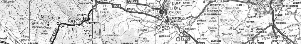


16 Legend Proposed Turbine Locations Blairadam Forest Development Site Location: I:\JEIA\Projects\JE30456\Technical\GIS\MXD\Final Figures\NTS_Figure 01_Site Location.mxd Crown copyright and database right All rights reserved. Ordnance Survey licence no ± Project name: Blairadam Forest Wind Farm Title : Site Location Plan Date: 25/11/2013 A3 1:150, REV: A Created by : KW 4 6 A3 8 Kilometres NTS Figure 1
17 Legend # Proposed Turbine Locations Permanent Met Mast Development Site Boundary Red Line Application Boundary Current Borrow Pit Area Proposed Borrow Pit Extension Current Borrow Pit Stockpile Area New Track Upgrade Existing Track Crane Hardstandings (30m x 50m) Turning Head (70m x 35m) Met Mast Assembly Area (25m x 15m) Construction Compound (50m x 50m) Control Building and Substation Compound (50m x 40m) T11 T04 T10 Location: C:\Users\cdennison\Documents\blairaddam\GIS\MXD\Final Figures\NTS_Figure 02_Proposed Site Layout Plan_revB.mxd T03 T02 T01 T09 T06 T05 ± T08 T07 # Crown copyright and database right All rights reserved. Ordnance Survey licence no Project name: Blairadam Forest Wind Farm Title : Proposed Site Layout Date: 13/12/2013 A3 1:12, Rev: B Created by : KW A Metres NTS Figure 2
 2000 TRANSFORMER KIOSK (3.0m x 2.5m x 2.")
18 Legend (To blade tip) (Blade) Ø Project Name: Blairadam Forest Wind Farm Title: TRANSFORMER KIOSK (3.0m x 2.5m x 2.5m) 2000 TRANSFORMER KIOSK (3.0m x 2.5m x 2.5m) NOTE WIND TURBINE DATA BASED ON RePOWER MM92) Candidate Wind Turbine Date: Nov 13 Created By: AP SCALE A m Rev: A3 NTS Figure 3