Piedmont Triad Region CommunityViz Model. From Guidebook to Utilization
|
|
|
- Brett Farmer
- 6 years ago
- Views:
Transcription
1 Piedmont Triad Region CommunityViz Model From Guidebook to Utilization
2 Today s Activities Regional Modeling in the Piedmont Triad What is CommunityViz? Steering Committee Structure Project Milestones Decision Time Next Meeting
3 Creating a new standard for REGIONAL MODELING in the PIEDMONT TRIAD


4 Travel Demand Model (PTRM) Highway and Street Network Socio-Economic Data Travel Demand Modeling Tool - PTRM Travel Behavior and Field Observation Data Vehicles (Trip Based) Truck Freight (Advanced Tour Based) Microscopic VMT, V/C Truck Movements, Commodity Distribution Signalization, Timing Development of MTP Traffic Engineering and Operations
 Tool - TBEST High Level Route and System Planning Ridership Projections Local and Regional Transit Network Designs")
5 Transit Planning (TBEST) GTFS Transit Planning and Ridership Forecast Parcel Data DU s, Sq. Ft., Use Route Design and Analysis Tool Remix Transit Forecasting (Parcel Based) Tool - TBEST High Level Route and System Planning Ridership Projections Local and Regional Transit Network Designs Performance Measures Internal Analyses Public Engagement and Education PTRM Reference Data Economic Development Benefits Title VI Analysis FTA and State Grants System Comparisons
6 Scenario Planning (CommunityViz) Community Development Plans Scenario Planning (Parcel Based) Tool CommunityViz Parcel Data DU s, Sq. Ft., Use Visioning and Scenario Development Scenario Comparison and Community Impacts Education and Engagement Strategic Direction Suitability Analysis Buildout and Growth Scenario Performance Score Cards Economic Benefits Interactive 3D Articulating Benefits Frame Stakeholder Interactions Setting Budget Goals and Priorities Development of SE Date Capital Improvement Plan, Resource Allocation, Program of Projects Public and Community Meetings Comprehensive Community Development Plan


7 Regional Modeling Program PTRM, TBEST, Comprehensive Transportation Plan, Metropolitan Transportation Plan, Congestion Management Plan, NEPA Process, Comprehensive Community Development Plan, Capital Improvement Plans SE Data Common Themes and Elements Parcel Data Land Use Plans Economic Benefits Performance Measures Growth Scenarios Public Engagement
8 A High Level Overview COMMUNITYVIZ
9 WHAT IS?


")
10 Software Platform CommunityViz v. 5.1 ArcGIS Desktop v ArcGIS Spatial Analyst ArcGIS 3D Analyst ESRI City Engine (Required) (Recommended) (Optional) (Optional)
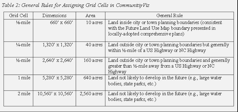
11 Preliminary List of Data Needs Carrying Capacity Wetlands Water Bodies Stream Buffers Permanent Conservation Areas Existing Rights-of-Way Others? Build Out Potential Parcels & Grid Cells Development Status Assignments Community Type Assignments Development Lookup Table (H/B/D) Watershed Boundaries Site Validation Studies Aerial Photography Land Suitability Analysis Major Roads Interchange Locations Major Intersections Metropolitan Centers Water/Sewer Service Areas Major Activity Centers Town Centers Flood Hazard Areas Watershed Protection Areas Growth Allocation Control Totals by Category P/HH & Employee Space Ratios Reporting Study Area Boundary Planning Jurisdiction Boundaries Traffic Analysis Zones
12 Your homework assignment 1. Read the Guidebook 2. Watch the Videos 3. Read the Guidebook
13 A Case for a Formal Sturctue STEERING COMMITTEE STRUCTURE
14 Is there a need to be formal? Decisions impacting numerous agencies Decisions will have a cascading effect Helps with documentation for future reference Its not PART s project Credibility outside the region Maybe political landmines ahead
15 Potential Time & Resources Partner Primary Responsibilities Commitment Level PART Program Manager Data Collection (Priority & Urban Areas) PTRM Coordination Regional Coordination Activities CommunityViz Model Custodian & Maintenance (PTRM Study Area) Data Sharing Center Dedicated Staff Resources Some Funding PTRC Data Collection (Rural Areas) Regional Coordination Activities CommunityViz Model Custodian & Maintenance (Outside PTRM Study Area) Data Sharing Center CommunityViz Model Calibration (Growth Allocation) Staff Resources Some Funding Cities & Counties Data Inputs Quality Control Staff Resources MPOs & RPOs Data Inputs CommunityViz Model Calibration (Growth Allocation) Staff Resources NCDOT Oversight Staff Resources Potential Funding Partner

16 O-Chart CV Steering Committee Co-Chairs?? Official Roster Meeting Summary / Minutes PART Project Management
17 Be flexible, be nimble but we do have a deadline PROJECT MILESTONE
18 Potential Project Milestone Schedule Piedmont Triad CommunityViz Model Review & Instill New Data Protocols Data Collection Activities Development Status Coding Community Type Coding Development Constraints Development Lookup Table Values Land Suitability Analysis Factors Growth Forecasts Build CommunityViz Model Carrying Capacity Module Buildout Potential Module Land Suitability Module Growth Allocation Module Validate/Calibrate Model Results Piedmont Triad Regional (Travel Demand) Model CommunityViz Communication Protocols Partnering Strategy Project Steering Committee Focus Group Meetings Business & Development Interests Utility Service Providers Planning Officials Policy-Maker Briefings Metropolitan Planning Organizations Rural Planning Organizations Technical Staff Meetings Metropolitan Planning Organizations Rural Planning Organizations City & County Coordination Events Piedmont Triad Regional Model Team Documentation CommunityViz Model Technical Document Note: = denotes the need for a meeting event Month 1 Month 2 Month 3 Month 4 Month 5 Month 6 Month 7 Month 8 Month 9 Month 10 Month 11 Month 12 OPERATIONAL BY EARLY 2019
19 We have a motion on the floor, do I have a second? TIME FOR A FEW DECISIONS


20 Bottom-Up Approach Carrying Capacity Analysis Development Status Assignments Land Suitability Analysis Calculations Community Type Assignments & Build-Out Estimates Growth Allocation

21
22 5 Steps to Decision Making Have all Necessary Info Keep Emotions in Check Seek Counsel from Others Consider Impact on Others Be Committed to the Decision
23 Piedmont Triad Region CommunityViz Model Initiative Model Architecture Development Potential (by Grid Cell & Type) 4 Layer Identification & Data Manipulation Areas Not Available for Development (DEV_CON) Highly-Constrained Areas Map Single Family Dwelling Units Water Bodies Wetlands Data Manipulation & Coding (Grid Cell Level Reporting) Developed Existing Development Inventory (PTRM SE Data Sets 2015) Multifamily Dwelling Units Carrying Capacity Analysis Permanent Stream Buffers Conservation Areas Existing Right-of-Way Areas Available for Development (DEV_AREA) Build-Out Potential Analysis Development Status Community Type 2 Watershed 1 Development LookupTable 3 Max Lot Coverage for Watershed Areas Site Efficiency Factor 4 Buildable Portion of a Lot or Parcel (BUILD_AREA) Development Status (DEV_STAT) Redevelopment Undeveloped Future Year Development Yield Minus Existing Development Inventory Future Year Development Yield (DEV_STAT, CT_CAT, JURIS) Model Lookup Tables for Each Jurisdiction Retail (Highway) Retail (Other) Industrial Jurisdiction TAZ Community Type (CT_CAT) Service 1 = Watershed categories should match those used by the State of North Carolina: Watershed II (Critical), Watershed II (Protected), Watershed III (Critical), Watershed III (Protected), Watershed IV (Critical) and Watershed IV (Protected). Permanent Open Space No Development Potential Office Education 2 = See the Piedmont Triad Region CommunityViz Model Guidebook for a list of community types recommended for the region (a expanded list compared to the Piedmont Together project). Committed Development Committed Development Inventory University/College Piedmont-Triad CommunityViz Model v = A development lookup table for the Piedmont Triad Region CommunityViz Model should contain the following information for each community type category and jurisdiction: county, jurisdiction code, average FAR, average density, average density by watershed protection category, percent residential development, percent non-residential development, percent single family development, percent multifamily development, percent low-traffic industrial development, percent high-traffic industrial development, percent low-traffic retail development, percent high-traffic retail development, percent low-traffic service development, percent high-traffic service development, and percent government office development. 4 = Residential and employment categories used in CommunityViz match those used in the Piedmont Triad Regional (Travel Demand) Model. Single-family and multi-family dwelling units are later combined into households for the PTRM. 4 = An allowance for on-site infrastructure needed to serve new development (e.g., streets, storm water ponds, etc.). Applied to all grid cells in the region not yet developed. Reported as the percentage of a parcel remaining for development after the removal of areas identified for supporting infrastructure. Build Out Potential Land Suitability Analysis 6 Layer Identification & Data Manipulation 6 Major Activity Interchanges Centers Major Town Centers Intersections Flood Hazard Major Roads Areas Metropolitan Watershed Centers Protection Areas Assign Weightings to LSA Variables (0 10) Calculate LSA Score (0 100) TAZ Level Calculations 9 Base Year Students x 130% Base Year Group Quarters Population x 130% Adjusted for Each Horizon Year (Accounting for Previous Horizon Year Allocation Period) Future Year Development Assignment (ALLO Data Column Series) Growth Allocation Composite Maps Growth Allocation by Control Total Category & Horizon Year (by TAZ & Type) University/College Total Enrolled K-12 Students Students (Full-Time) Students (Full-Time) University/College University/College Total Enrolled Students (FTE) Students (Part-Time) Students (Part-Time) Group Quarters Population MRM SE Data Files 10 Sewer Service Areas Water Service Areas Land Suitability Composite Maps Growth Allocation 7 Build Out Potential Growth Allocation by Control Total Category & Horizon Year (by Grid Cell & Type) 5 = The Piedmont Triad Regional CommunityViz Model uses the Land Suitability Wizard in the software. Developed Existing Development Inventory (PTRM SE Data Sets 2015) Adjusted for Each Horizon Year (Accounting for Previous Horizon Year Allocation Period) Single Family Dwelling Units Service Legend Major Category Model Input Data 6 = The Land Suitability Analysis Wizard will be run for three horizon years: 2020, 2030 and = The Piedmont Triad Regional CommunityViz Model uses the Allocator 5 Wizard in the software. 8 = Growth is allocated to grid cells for the following growth categories: single family residential, multifamily residential, low-traffic industrial employees, high-traffic industrial employees, low-traffic retail employees, high-traffic retail employees, low-traffic service employees, high-traffic service employees, and government office employees. 9 = Growth is allocated to traffic analysis zones for the following growth categories: K-12 students, high school students, college students and group quarters population. Dynamic Model Attribute Resource Model Assumptio Calculatio Map Output n n Grid Cell Level Calculations 8 Development Status (DEV_STAT) Community Type (CT_CAT) Redevelopment Undeveloped Permanent Open Space Committed Development Population & Employment Control Totals ( ) Population & Employment Control Totals ( ) No Development Potential Committed Development Inventory Future Year Development Assignment (ALLO Data Column Series) Growth Allocation Composite Maps Multifamily Office Dwelling Units Retail (Highway) Education MRM SE Data Files 10 Retail (Other) University/College Industrial 10 = Data tables (*.dbf format) will be generated in CommunityViz using the Summary Statistics ArcTool in ArcGIS. Grid cell data will be summarized by traffic analysis zone for all ten growth allocation categories. This data will be provided to the PTRM team for future models runs. Last Revised on June 30, 2017

24 Priority Areas Grid (small) and TAZ Reviewed and updated annually TBEST Model Core Areas Grid (medium) and TAZ Updated Every four years PTRM updates, City Comp Plans Expanded Area Grid Updated periodically RPO CTP s, Town Comp Plans
25
26 NEXT MEETING?
Chapter #9 TRAVEL DEMAND MODEL
 Chapter #9 TRAVEL DEMAND MODEL TABLE OF CONTENTS 9.0 Travel Demand Model...9-1 9.1 Introduction...9-1 9.2 Overview...9-1 9.2.1 Study Area...9-1 9.2.2 Travel Demand Modeling Process...9-3 9.3 The Memphis
Chapter 3: Growth Forecasts and Model Assumptions
 Chapter 3: Growth Forecasts and Model Assumptions A. Introduction A new transportation demand model was created in 2008 as part of the analysis that is the foundation of this plan. The City s transportation
2040 MTP Information Session Transportation Alternatives Analysis
 2040 MTP Information Session Transportation Alternatives Analysis 2040 Metropolitan Transportation Plan TP? a guide for major transportation investments 59,313 MPO Planning Boundaries About the MPO DCHC-MPO
Winston-Salem Urban Area Metropolitan Planning Organization Transportation Advisory Committee Action Request
 Winston-Salem Urban Area Metropolitan Planning Organization Transportation Advisory Committee Action Request Meeting Date: May 17, 2018 Agenda Item Number: 6 Action Requested: Consideration of an Appendix
APPENDIX H: TRAVEL DEMAND MODEL VALIDATION AND ANALYSIS
 APPENDIX H: TRAVEL DEMAND MODEL VALIDATION AND ANALYSIS Travel demand models (TDM) simulate current travel conditions and forecast future travel patterns and conditions based on planned system improvements
GWRC Scenario Planning Phase II
 GWRC Scenario Planning Phase II DRAFT SCOPE OF WORK/BUDGET PARSONS BRINCKERHOFF & SEVEN HILLS TOWN PLANNING G ROUP A PRIL, 2014 BACKGROUND Your Vision, Our Future completed in 2009 (Scenario Planning Phase
GUIDE FOR THE PREPARATION OF TRAFFIC IMPACT STUDIES
 GUIDE FOR THE PREPARATION OF TRAFFIC IMPACT STUDIES Adopted by Town Council on November 25, 2008 Prepared By: HNTB Engineering Department Planning Department TABLE OF CONTENTS I. INTRODUCTION... 1 II.
SCENARIO PLANNING 12
 12 SCENARIO PLANNING Scenario planning represents the next generation of analytical processes created to evaluate the influence of development intensities and land use patterns on the efficiency of a proposed
Performance Based Transportation Project Assessment. Utilizing Travel Demand Model Data and Dynamic Economic Modeling
 Performance Based Transportation Project Assessment Utilizing Travel Demand Model Data and Dynamic Economic Modeling Colin Belle, Metropolitan Planner Region 1 Planning Council (R1PC), Rockford Illinois
Travel Demand Forecasting User Guide
 Travel Demand Forecasting User Guide A Supplement to the Regional Transitway Guidelines Metropolitan Council February 2012 This document supplements the Project Development, Leadership, and Oversight discussion
CHAPTER 1 Introduction
 CHAPTER 1 Introduction The Charlotte region is demographically diverse, economically dynamic, and rapidly growing. These circumstances present new challenges and opportunities, including the critical expansion
Charlottesville Albemarle MPO:
 Charlottesville Albemarle MPO: Applying The Eco-Logical Approach To Small MPOs September 21, 2015 Charlottesville Albemarle Metropolitan Planning Organization (CAMPO) and The Thomas Jefferson Planning
DCHC RPAT IMPLEMENTATION
 FINAL REPORT DCHC RPAT IMPLEMENTATION 3.11.2016 PREPARED FOR: FEDERAL HIGHWAY ADMINISTRATION 101 City Hall Plaza Durham, NC 27701 919.560.4366 www.dchcmpo.org SUBMITTED BY: DCHC MPO DCHC RPAT IMPLEMENTATION
Context. Case Study: Albany, New York. Overview
 Case Study: Albany, New York Overview The Capital District, a four-county region surrounding Albany, New York, has experienced dramatic growth in vehicle-miles of travel (VMT) in recent years, which has
Triad Air Quality Conformity Determination Report 2040 Metropolitan Transportation Plan; and Transportation Improvement Plan (TIP)
") Triad Air Quality Conformity Determination Report 2040 Metropolitan Transportation Plan; and 2016-2020 Transportation Improvement Plan (TIP) Burlington-Graham Metropolitan Planning Organization (Guilford
Triad Air Quality Conformity Determination Report 2040 Metropolitan Transportation Plan; and 2016-2020 Transportation Improvement Plan (TIP) Burlington-Graham Metropolitan Planning Organization (Guilford
Integrated Land Use, Transportation & Air Quality Planning in the Sacramento Region
 Integrated Land Use, Transportation & Air Quality Planning in the Sacramento Region National Association of Regional Councils September 12, 2008 Matt Carpenter Sacramento Area Council of Governments 6
FHWA s Eco-Logical Process: Uses in Performance-Based planning
 FHWA s Eco-Logical Process: Uses in Performance-Based planning August 25, 2014 Charlottesville Albemarle Metropolitan Planning Organization (CAMPO) and The Thomas Jefferson Planning District Commission
FBRMPO Land Use and Socio-Economic Data Forecasting Study Request for Proposals
 FBRMPO Land Use and Socio-Economic Data Forecasting Study Request for Proposals Release Date: April 20, 2018 Introduction and Overview About the French Broad River MPO The French Broad River MPO (FBRMPO)
BOSTON REGION METROPOLITAN PLANNING ORGANIZATION
 PLANNING ORGANIZATIO BOSTON REGION MPO NMETROPOLITAN BOSTON REGION METROPOLITAN PLANNING ORGANIZATION Stephanie Pollack, MassDOT Secretary and CEO and MPO Chair Karl H. Quackenbush, Executive Director,
Appendix C: Scenarios and Future Drivers Impacting Transportation
 Prepared for Washington County Prepared by David Evans and Associates, Inc. 2100 SW River Parkway Portland, Oregon 97201 TABLE OF CONTENTS 1. INTRODUCTION... 2 2. SCENARIOS PLANNING OVERVIEW... 2 3. SCENARIOS
INTRODUCTION... 4 DATA COLLECTION AND ASSESSMENT... 6 I-1. DATA COLLECTION AND ASSESSMENT... 6 I-1.1 CTP Inventory and Assessment... 6 I-1.
 1 INTRODUCTION... 4 DATA COLLECTION AND ASSESSMENT... 6 I-1. DATA COLLECTION AND ASSESSMENT... 6 I-1.1 CTP Inventory and Assessment... 6 I-1.2 Bicycle and Pedestrian Inventory and Assessment... 6 I-1.3
Chapter 8 Travel Demand Forecasting & Modeling
 Chapter 8 Travel Demand Forecasting & Modeling The Travel Demand Forecasting and Modeling process for the Jackson MPO was developed in cooperation between the Region 2 Planning Commission (R2PC) and the
TOWN OF ENFIELD TIF DISTRICT BUILD OUT ANALYSIS
 TOWN OF ENFIELD TIF DISTRICT BUILD OUT ANALYSIS Prepared By: Upper Valley Lake Sunapee Regional Planning Commission 30 Bank Street Lebanon, NH 03766 Prepared For: Town of Enfield Tax Increment Finance
Creating a Transit Supply Index. Andrew Keller Regional Transportation Authority and University of Illinois at Chicago
 Creating a Transit Supply Index Andrew Keller Regional Transportation Authority and University of Illinois at Chicago Presented at Transport Chicago Conference June 1, 2012 Introduction This master's project
Conformity Analysis and Determination Report
 Conformity Analysis and Determination Report 2035 Long Range Transportation Plans: Burlington-Graham Metropolitan Planning Organization (Guilford County) Greensboro Urban Area Metropolitan Planning Organization
Webinar Series for Comprehensive Plan Updates. Transportation Overview
 Webinar Series for Comprehensive Plan Updates Transportation Overview Presented by Michael Larson and Mark Filipi August 18, 2016 2040 Transportation Policy Plan Adopted January 14 th, 2015 Multimodal
Pennichuck Brook Watershed Buildout Analysis December 2003
 INTRODUCTION The Pennichuck Brook watershed (Figure 1) includes approximately 17,700 acres within the communities of Amherst, Hollis, Merrimack, Milford and Nashua and is the primary drinking water supply
EIGHT PLANNING FACTORS
 EIGHT PLANNING FACTORS Under the provisions of SAFETEA-LU, all Metropolitan Planning Organizations (MPOs) are required to consider eight (8) broad planning factors in the development of multi-modal transportation
Residential Multifamily res. Retail Industrial Vacant
 Land Use Zone Residential Multifamily res. Retail Industrial Vacant Residential Multifamily res. Retail Industrial Vacant Residential Multifamily res. Retail Industrial Vacant Make and use coefficients
Hillsborough County 2045 Population and Employment Projections and Allocations. Project Update. Plant City City Commission February 26, 2018
 Hillsborough County 2045 Population and Employment Projections and Allocations Project Update Plant City City Commission February 26, 2018 What will Hillsborough County look like in 25 years? Working with
Appendix D: Functional Classification Criteria and Characteristics, and MnDOT Access Guidance
 APPENDICES Appendix D: Functional Classification Criteria and Characteristics, and MnDOT Access Guidance D.1 Functional classification identifies the role a highway or street plays in the transportation
Alameda Countywide Transportation Plan Update Evaluation Outcomes
 TAWG Meeting 07/14/11 Attachment 06 Handout Alameda Countywide Transportation Plan Update Evaluation Outcomes presented to Technical Advisory Working Group presented by Cambridge Systematics, Inc. July
Envisioning the Future: A History of Regional Planning Initiatives, Studies, and Plans
 Express Commuter Transit Travel Demand Management Regional Vanpool Program Regional Transportation Planning Piedmont Triad Regional Model Training and Education Convening and Cooperation Envisioning the
Scope of Work. Land Use, Transportation, and Resilience: Scenario Planning Study East Tangipahoa Area State Project No. H RPC Task: ETangi
 Scope of Work Land Use, Transportation, and Resilience: Scenario Planning Study East Tangipahoa Area State Project No. H.013576 RPC Task: ETangi Project Description The Regional Planning Commission is
Winston-Salem Urban Area Metropolitan Planning Organization (WSMPO) Prioritization 4.0 Evaluation Criteria and Point Assignment Process
 Prioritization 4.0 Evaluation Criteria and Point Assignment Process") The following methodology was developed by the Winston-Salem Urban Area Metropolitan Planning Organization (WSMPO) for the purpose of determining priorities for transportation funding, as carried out through
The following methodology was developed by the Winston-Salem Urban Area Metropolitan Planning Organization (WSMPO) for the purpose of determining priorities for transportation funding, as carried out through
Transportation and Land Use
 Transportation and Land Use Making the connection OPC Cincinnati Section March 2, 2007 Topics today are the transportation-land use connection; how land use is considered in the regional transportation
Technical Memorandum. 720 SW Washington Suite 500 Portland, OR dksassociates.com. DATE: July 12, 2017
 Technical Memorandum DATE: July 12, 2017 TO: Kay Bork City of Veneta Bill Johnston, AICP Oregon Department of Transportation Christina McDaniel-Wilson, PE Oregon Department of Transportation Keith Blair,
Under recently updated FHWA guidelines, the LRTP must be updated every four (4) years. The most recent LRTP is the 2035 Plan, adopted in early 2009.
 years. The most recent LRTP is the 2035 Plan, adopted in early 2009.") PLANS, POLICIES AND PROCESSES OF THE MPO The Winston-Salem Urban Area MPO is responsible for creating and maintaining many documents essential to the on-going transportation planning effort. These documents
PLANS, POLICIES AND PROCESSES OF THE MPO The Winston-Salem Urban Area MPO is responsible for creating and maintaining many documents essential to the on-going transportation planning effort. These documents
1RUWKZHVW#:LFKLWD 0DMRU#,QYHVWPHQW#6WXG\
 1RUWKZHVW#:LFKLWD 0DMRU#,QYHVWPHQW#6WXG\ Executive Summary 3UHSDUHGýIRUã 3UHSDUHGýE\ã.DQVDVý'HSDUWPHQWýRI 7UDQVSRUWDWLRQ,QýDVVRFLDWLRQýZLWKã (DUWKý7HFKý,QFï EXECUTIVE SUMMARY Introduction This Northwest
Appendix D Functional Classification Criteria and Characteristics, and MnDOT Access Guidance
 Appendix D Functional Classification Criteria and Characteristics, and MnDOT Access Guidance Functional classification identifies the role a highway or street plays in the transportation system. Some highways
Metropolitan Transportation Plan
 2045 CRTPO Metropolitan Transportation Plan Prepared for Prepared by CRTPO 2045 MTP TRANSPORTATION FOR OUR Growing Tomorrow iii Resolution iv TRANSPORTATION FOR OUR Growing Tomorrow CRTPO 2045 MTP Resolution
Regional Evaluation Decision tool for Smart Growth
 Regional Evaluation Decision tool for Smart Growth Maren Outwater, Robert Cervero, Jerry Walters, Colin Smith, Christopher Gray, Rich Kuzmyak Objectives This project is one of the SHRP 2 Capacity projects
EXHIBIT 2 SCOPE OF SERVICES FOR THE GAINESVILLE URBANIZED AREA YEAR 2040 LONG RANGE TRANSPORTATION PLAN UPDATE. Prepared by:
 CA.5 EXHIBIT 2 SCOPE OF SERVICES FOR THE GAINESVILLE URBANIZED AREA YEAR 2040 LONG RANGE TRANSPORTATION PLAN UPDATE Prepared by: Metropolitan Transportation Planning Organization for the Gainesville Urbanized
Stephen Fitzroy Glen Weisbrod Naomi Stein Economic Development Research Group, Inc. USA
 Stephen Fitzroy Glen Weisbrod Naomi Stein Economic Development Research Group, Inc. USA www.edrgroup.com International Transportation Forum Round Table Ex-post assessments of transport investments and
FRESNO COG TRANSPORTATION MODEL DEVELOPMENT AND SUPPORT
 Proposal for Consulting Services for FRESNO COG TRANSPORTATION MODEL DEVELOPMENT AND SUPPORT Prepared for: Fresno Council of Governments (Fresno COG) P12-3814-WC Table of Contents OVERVIEW... 1 DETAILED
Database and Travel Demand Model
 Database and Travel Demand Model 7 The CMP legislation requires every CMA, in consultation with the regional transportation planning agency (the Metropolitan Transportation Commission (MTC) in the Bay
ENVIRONMENTAL JUSTICE ASSESSMENT
 14 ENVIRONMENTAL JUSTICE ASSESSMENT As part of its regional equity program (discussed in Chapter 9), the MPO performed a detailed, system-level analysis of transportation equity in the region, examining
MPO/RPO Briefings. MPO/RPO Briefing. Briefing Topics Plan framework o NCDOT Policy to Projects process o Relationship to local/regional plans
 7/7/2011 MPO/RPO Briefings July 2011 MPO/RPO Briefing Briefing Topics 1. 2040 Plan framework o NCDOT Policy to Projects process o Relationship to local/regional plans 2. Study process o Schedule o Public
APPENDIX D: METHODOLOGY FOR ESTIMATING VEHICLE MILES TRAVELED AND GREENHOUSE GAS REDUCTIONS IN THE 2017 REGIONAL TRANSPORTATION PLAN
 APPENDIX D: METHODOLOGY FOR ESTIMATING VEHICLE MILES TRAVELED AND GREENHOUSE GAS REDUCTIONS IN THE 2017 REGIONAL TRANSPORTATION PLAN Table of Contents Overview... 2 Background... 2 Part 1: Information
US 301 / Rte 207 Arterial Management Plan Kick-off Meeting
 US 301 / Rte 207 Arterial Management Plan Kick-off Meeting January 17, 2017 L.E. Smoot Memorial Library, Meeting Room A King George, VA Agenda 1. Introductions / goal of today s meeting 2. Purpose of Study
Secondary and Cumulative Effects Analysis Guidelines
 Maryland State Highway Administration s Secondary and Cumulative Effects Analysis Guidelines For Environmental Impact Statements and Environmental Assessments Revised 6/28/00 I. INTRODUCTION In compliance
TOWN OF BARGERSVILLE DEPARTMENT OF DEVELOPMENT TRAFFIC STUDY GUIDELINES
 TOWN OF BARGERSVILLE DEPARTMENT OF DEVELOPMENT TRAFFIC STUDY GUIDELINES Town of Bargersville Department of Development 24 North Main Street, P.O. Box 420 Bargersville, Indiana 46106 Adopted by the Bargersville
Introduction. Performance Measurement. Pg. 01
 Pg. 01 Introduction The Alamo Area recognizes the importance of transportation performance tracking, goal setting and measurement to provide greater accountability and transparency and to achieve a more
TRANSIT SERVICE GUIDELINES
 CHATHAM AREA TRANSIT AUTHORITY FEBRUARY 2014 Table of Contents 1. PURPOSE... 3 2. CAT SERVICE GUIDELINES... 3 3. TRAVEL MARKETS... 4 4. TRANSIT COVERAGE... 4 5. TRANSIT ACCESS... 4 6. BUS STOP SPACING
December 16, 2011 To: Gerrit Knaap, Fred Ducca From: Graham Petto Subject: Transit Friendly Scenario Development
 Preinkert Field House College Park, Maryland 20742 P: 301.405.6283 F: 301.314.5639 http://www.smartgrowth.umd.edu NATIONAL CENTER FOR SMART GROWTH RESEARCH AND EDUCATION December 16, 2011 To: Gerrit Knaap,
DRCOG s Land Use and Travel Demand Models. Presentation to the Institute of Transportation Engineers Colorado/Wyoming Section 12 December 2014
 DRCOG s Land Use and Travel Demand Models Presentation to the Institute of Transportation Engineers Colorado/Wyoming Section 12 December 2014 The Dirty Secret Essentially, all models are wrong, but some
PERFORMANCE-BASED PLANNING AND PROGRAMMING
 February 2017 performance-based planning and programming Boston Region MPO PERFORMANCE-BASED PLANNING AND PROGRAMMING WHAT IS PERFORMANCE-BASED PLANNING AND PROGRAMMING? Performance-based planning and
Congestion Management Process (CMP)
") Congestion Management Process (CMP) Introduction The Congestion Management Process (CMP) is a systematic, data-driven, and regionally accepted approach that aims to improve the performance of the transportation
Congestion Management Process (CMP) Introduction The Congestion Management Process (CMP) is a systematic, data-driven, and regionally accepted approach that aims to improve the performance of the transportation
Proposed Comprehensive Update to the State of Rhode Island s Congestion Management Process
 Proposed Comprehensive Update to the State of Rhode Island s Statewide Planning Program January 2018 Summary Outline of of Action Steps 1. Develop Objectives for Congestion Management What is the desired
CHAPTER 4 FUTURE TRENDS
 CHAPTER 4 FUTURE TRENDS 4.1 LAND USE SCENARIO PLANNING Scenario planning represents the next generation of analytical processes created to evaluate the influence of development intensities and land use
North Carolina Statewide Freight Plan
 Greater Charlotte Regional Freight Peer Exchange North Carolina Statewide Freight Plan Derry Schmidt & Terry Arellano NCDOT Planning Branch NC : Two Phase Process Phase 1 Interim MAP-21 compliant freight
HORIZON 2030: Plan Projects November 2005
 Horizon PROJECTS 2030 Projects 10-1 10-2 The Horizon 2030 Project Information section is comprised of individual project information in alphabetical order by project name. The information provided for
CHAPTER 7. TRAVEL PATTERNS AND TRAVEL FORECASTING
 CHAPTER 7. TRAVEL PATTERNS AND TRAVEL FORECASTING TRAVEL PATTERNS Northwest Arkansas has experienced unprecedented growth in population and employment in the past 25 years. The economic vitality and diversity
Refined Statewide California Transportation Model. Progress Report November 2009
 Refined Statewide California Transportation Model Progress Report November 2009 Study area - the State of California. Forecast trips made on a typical fall / spring weekday i.e. when schools are in session.
TDOT's New Staffs, Future Plans, and opportunities for Collaboration with MPOs
 TDOT's New Staffs, Future Plans, and opportunities for Collaboration with MPOs David Lee, Assistant Director February 7, 2017 Organizational Chart Long Range Planning Organizational Chart Data Management
2. Guiding Principles, Objectives, and Policies
 2. Guiding Principles, Objectives, and Policies INTRODUCTION The guiding principles for the 2040 MTP Update establish the vision and key focus areas for this planning effort. They combine the guidance
Regional Travel Demand Model (RTDM) Technical Documentation Association of Monterey Bay Area Governments (AMBAG) 1. Introduction:
 Technical Documentation Association of Monterey Bay Area Governments (AMBAG) 1. Introduction:") Regional Travel Demand Model (RTDM) Technical Documentation Association of Monterey Bay Area Governments (AMBAG) 1. Introduction: The Association of Monterey Bay Area Governments (AMBAG is the federally
Regional Travel Demand Model (RTDM) Technical Documentation Association of Monterey Bay Area Governments (AMBAG) 1. Introduction: The Association of Monterey Bay Area Governments (AMBAG is the federally
Data Driven Results: North Carolina s Strategic Prioritization Process through SPOT On!ine. NCDOT Strategic Prioritization Office April 4, 2016
 Data Driven Results: North Carolina s Strategic Prioritization Process through SPOT On!ine NCDOT Strategic Prioritization Office April 4, 2016 Agenda Why We Prioritize Background Strategic Investments
Winston-Salem Urban Area Metropolitan Planning Organization (WSUAMPO) Prioritization 3.0 Evaluation Criteria and Point Assignment Process
 Prioritization 3.0 Evaluation Criteria and Point Assignment Process") The following methodology has been developed by the Winston-Salem Urban Area Metropolitan Planning Organization (WSUAMPO) for the purpose of determining priorities for transportation funding, as carried
The following methodology has been developed by the Winston-Salem Urban Area Metropolitan Planning Organization (WSUAMPO) for the purpose of determining priorities for transportation funding, as carried
Updated Traffic Impact Analysis Regulations Administrative Guidelines
 Updated Traffic Impact Analysis Regulations Administrative Guidelines 24VAC30-155 January 2012 Land Development Section Transportation and Mobility Planning Division Virginia Department of Transportation
VEHICLES MILES TRAVELED (VMT) TRAFFIC IMPACT METRIC
 TRAFFIC IMPACT METRIC") VEHICLES MILES TRAVELED (VMT) TRAFFIC IMPACT METRIC A project-specific quantified analysis of the MGA Campus has been undertaken to compare BAU to the project including the project s VMT reduction program
VEHICLES MILES TRAVELED (VMT) TRAFFIC IMPACT METRIC A project-specific quantified analysis of the MGA Campus has been undertaken to compare BAU to the project including the project s VMT reduction program
Free Bridge Congestion Relief Project: Using FHWA s Eco-Logical Process
 Free Bridge Congestion Relief Project: Using FHWA s Eco-Logical Process An Ecosystem Approach to Developing Infrastructure Projects June 27, 2014 Charlottesville Albemarle Metropolitan Planning Organization
CHAPTER 2 - TRAVEL DEMAND MODEL DEVELOPMENT
 CHAPTER 2 - TRAVEL DEMAND MODEL DEVELOPMENT 2.1 EXISTING TRAVEL DEMAND MODEL In order to accurately project future year traffic volumes within this regional study area, it was first necessary to construct
MOBILITY AND ALTERNATIVES ANALYSIS
 6 MOBILITY AND ALTERNATIVES ANALYSIS BACK OF SECTION DIVIDER 6.0 Mobility and Alternatives Analysis Travel demand analysis provides a framework for the identification of transportation facilities and services
US 1 Regional Growth Strategy Shaping the Region s s Future
 US 1 Regional Growth Strategy Shaping the Region s s Future Central Jersey Transportation Forum July 20, 2006 Route 1 Regional Growth Strategy Work Flow US 1 Regional Growth Strategy Base Year Conditions
Project Application Guidelines. For the. Major New Capacity Program
 Transportation Review Advisory Council Project Application Guidelines For the Major New Capacity Program June 2017 Frequently Asked Questions and Answers 1. What is the Transportation Review Advisory Council
2035 LRTP Transportation Options Introduction
 2035 LRTP Transportation Options Introduction What is the 2035 LRTP? The 2035 Long-Range Transportation Plan (LRTP) is the guide for major transportation investments in the Durham-Chapel Hill-Carrboro
VEHICLE PARTICULATE EMISSIONS ANALYSIS
 VEHICLE PARTICULATE EMISSIONS ANALYSIS Prepared for ARIZONA DEPARTMENT OF TRANSPORTATION TRANSPORTATION PLANNING DIVISION MPOs/COGs AIR QUALITY POLICY AND LOCAL PROGRAMS SECTION AND YUMA METROPOLITAN PLANNING
Sustainable Return on Investment Benefits and Costs of Alternative Future Land Use Development Alternatives
 Sustainable Return on Investment Benefits and Costs of Alternative Future Land Use Development Alternatives Case Study of Goffstown, NH Northern New England Chapter of American Planning Association (NNECAPA)
SERPM8.0 TRAVEL DEMAND MODEL UPDATE DATA AVAILABILITY AND NEEDS
 SERPM8.0 TRAVEL DEMAND MODEL UPDATE DATA AVAILABILITY AND NEEDS UPDATED JANUARY 18 2017 UPDATES IN RED DATA ITEM DESCRIPTION/COMMENTS AGENCY/DETAILS/TIMING DATA STATUS A1 A2 Geographies for development
DRAFT MEMORANDUM DATE: 10/06/2017
 DATE: 10/06/2017 FROM: TO: SUBJECT: DRAFT MEMORANDUM Paul Silberman, P.E., PTOE, Sabra, Wang & Associates, Inc. Elisa Mitchell, P.E., Sabra, Wang & Associates, Inc. Laura Hodgson, LEED AP, Montgomery County
Standardization of Travel Demand Models
 Standardization of Travel Demand Models TNMUG Meeting November 14, 2013 The North Carolina Experience Leta F. Huntsinger, Ph.D., P.E. and Rhett Fussell, P.E. Background } North Carolina Profile } 18 MPOs,
SUBURBAN EDGE COMMUNITY ROLE COUNCIL ROLE ALL COMMUNITIES SUBURBAN EDGE
 Orderly and Efficient Land Use Align land use, development patterns, and infrastructure to make the best use of public and private investment. Plan and stage development for forecasted growth through 2040
Des Moines Area MPO. MPO Planning Subcommittee Meeting March 3, Des M oines Area M etropolitan Planning Organization
 Des Moines Area MPO MPO Planning Subcommittee Meeting March 3, 2014 2014 Des M oines Area M etropolitan Planning Organization Agenda 1. Call To Order 2. VOTE: Approval of Agenda 3. VOTE: Approval of Meeting
Jeff Gulden, PE, TE, JP Goates, MCMP, and Reid Ewing, Ph.D. Page 1 MIXED-USE DEVELOPMENT TRIP GENERATION MODEL
 Jeff Gulden, PE, TE, JP Goates, MCMP, and Reid Ewing, Ph.D. Page 1 MIXED-USE DEVELOPMENT TRIP GENERATION MODEL Original submission date: August 1, 2012 Revised submission date: November 13, 2012 Number
Integrated Transportation Plan. TAC Meeting September 16, 2014
 Integrated Transportation Plan TAC Meeting September 16, 2014 Project Schedule Today TAC Meeting October 10 TAC Meeting (teleconference) October 29 Public Workshop December 9 JIM Presentation Plan Contents
BOSTON REGION METROPOLITAN PLANNING ORGANIZATION MEMORANDUM
 BOSTON REGION METROPOLITAN PLANNING ORGANIZATION State Transportation Building Ten Park Plaza, Suite 2150 Boston, MA 02116-3968 Tel. (617) 973-7100 Fax (617) 973-8855 TTY (617) 973-7089 www.bostonmpo.org
Examining the Economic Trade-offs of Alternative Transportation Funding NC I-95 Economic Assessment
 Examining the Economic Trade-offs of Alternative Transportation Funding NC I-95 Economic Assessment presented to ITED Conference presented by Cambridge Systematics, Inc. Paula Dowell, PhD April 2014 Background
Metro Amherst-Buffalo Corridor Alternatives Analysis
 TASK 4 SCREENING METHODOLOGY & PRELIMINARY EVALUATION CRITERIA TECHNICAL MEMORANDUM Prepared for: Niagara Frontier Transportation Authority (NFTA) Prepared by: AECOM USA, Inc. October 2013 Table of Contents
PERFORMANCE-BASED PLANNING AND PROGRAMMING
 February 2017 performance-based planning and programming Boston Region MPO PERFORMANCE-BASED PLANNING AND PROGRAMMING WHAT IS PERFORMANCE-BASED PLANNING AND PROGRAMMING? Performance-based planning and
OPEN DATA & PROJECT TRACKER. Michael Chamberlain TPP, Data Management
 OPEN DATA & PROJECT TRACKER Michael Chamberlain TPP, Data Management October 11, 017 Table of contents 1 People 3 Attributes 4 3 Locations 5 4 Systems 6 5 Reports 7-8 6 Applications 8-13 7 Closing 14 Data
POLK COUNTY TPO Polk County 2060 Transportation Vision Plan Final Report. ADOPTED June 18, 2009
 POLK COUNTY TPO Polk County 2060 Transportation Vision Plan Final Report ADOPTED June 18, 2009 TABLE OF CONTENTS CHAPTER 1 Introduction and Prior Planning Effort...Page 1-1 CHAPTER 2 Population and Employment
CommunityViz in Transportation Planning and Modeling
 CommunityViz in Transportation Planning and Modeling CommunityViz software is an ArcGIS extension for planning and analysis. 1 At its core is a powerful, flexible modeling framework that allows users to
APPENDIX TRAVEL DEMAND MODELING OVERVIEW MAJOR FEATURES OF THE MODEL
 APPENDIX A TRAVEL DEMAND MODELING OVERVIEW The model set that the Central Transportation Planning Staff (CTPS), the Boston Region Metropolitan Planning Organization s (MPO) technical staff, uses for forecasting
TECHNICAL MEMORANDUM #3
 TECHNICAL MEMORANDUM #3 Date: November 2, 2005 Project #: 6389 To: US 97 & US 20 Refinement Plan Project Management Team (PMT) From: Sonia Hennum, P.E., Andrew Cibor, E.I.T., & Julia Kuhn, P.E. Project:
PROPOSED AMENDMENT OF THE I 76 INTEGRATED CORRIDOR MANAGEMENT PROJECT TO THE CONNECTIONS 2040 PLAN FOR GREATER PHILADELPHIA
 PROPOSED AMENDMENT OF THE I 76 INTEGRATED CORRIDOR MANAGEMENT PROJECT TO THE CONNECTIONS 2040 PLAN FOR GREATER PHILADELPHIA Background and Project Description In July 2013, the Delaware Valley Regional
Final Congestion Management Process
 Final Congestion Management Process 2015 Prepared by Tulare County Association of Governments 210 N. Church St., Suite B Visalia, California 93291 1. Introduction: What Is Congestion? Congestion can generally
Table Table 7.2 Potential Environmental Impacts and Mitigation Measures
 7.2 Natural Environment/Environmental Planning Executive Summary/Key Points The Environmental Consultation and Mitigation Plan establishes: o A process for consultation with environmental resource agencies
APPENDIX A PROJECT BUILDOUT ANALYSES
 APPENDIX A PROJECT BUILDOUT ANALYSES Project Effects Evaluated. The Mitigated Negative Declaration and Initial Study (MND/IS) is intended to evaluate the potential effects of the above-described general
Developing Dwelling Unit Equivalent (DUE) Rates Using an Activity Based Travel Demand Model
 Rates Using an Activity Based Travel Demand Model") Developing Dwelling Unit Equivalent (DUE) Rates Using an Activity Based Travel Demand Model Institute of Transportation Engineers ITE Western District Annual Meeting Phoenix, Arizona July 14-17, 2013 By:
Developing Dwelling Unit Equivalent (DUE) Rates Using an Activity Based Travel Demand Model Institute of Transportation Engineers ITE Western District Annual Meeting Phoenix, Arizona July 14-17, 2013 By: