Appendix J Greater Sage-grouse Habitat Equivalency Analysis
|
|
|
- Hilary Booth
- 6 years ago
- Views:
Transcription
1 TransWest Express EIS Appendix J Greater Sage-grouse Habitat Equivalency Analysis
2 TransWest Express EIS Appendix J J-1 Compliance with Applicable Greater Sage-grouse Polices and Applicant Proposed Mitigation J.1 Introduction The TransWest Express Transmission Line Project (Project) has been developed through the coordination of two separate co-lead agencies; the Bureau of Land Management (BLM) and Western Area Power Administration (Western). Western is not mandated with management of public lands and therefore does not currently have statutory regulations or policies regarding the management of greater sage-grouse. The BLM and other cooperating land management agencies, are currently participating in developing policy revisions and updates, or have recently updated policies and guidelines regarding the management of greater sage-grouse within the Project area. These policy updates are in response to on-going declines of the species across its range, agency responsibilities for sage-grouse conservation, and the March 2010 U.S. Fish and Wildlife Services 12 Month Findings for Petitions to List the Greater Sage-grouse as Threatened or Endangered under the Endangered Species Act (75 FR ). Several of these policy and regulation updates have been initiated or completed since the Applicant (TransWest Express LLC) submitted an amended Application for Transportation and Utility Systems and Facilities on Federal Lands (BLM Standard Form 299) in September of The BLM and Western have collaborated with cooperating agencies to prepare this EIS in accordance with current relevant law, regulation, policies, and plans that guide agency decisions which have potential to impact greater sage-grouse and its habitat. This appendix provides information on the planning process undertaken by the Applicant, BLM, Western, and cooperating agencies to prepare the EIS and develop the project in compliance with applicable law, regulation, policies, and plans regarding greater sage-grouse. The co-lead agencies and cooperators have collaborated to develop a Framework for Sage-grouse Impacts Analysis for the TransWest Express Transmission Project (2013; Exhibit J1) as the initial step to address potential impacts to greater sage-grouse during the development of the EIS. The framework outlines the approach to the greater sage-grouse impact analysis and mitigation required for the project and encourages the selection of an action alternative that would be consistent with agency missions and goals pertaining to sage-grouse conservation. The framework also was developed to facilitate relevant cooperating agency decisions and evaluation of compliance with applicable plans and policies that are not subject to National Environmental Policy Act review and not addressed in the EIS. J.2 Applicable Greater Sage-grouse Policies and Plans J.2.1 Federal J Bureau of Land Management Washington Office Instruction Memorandum Greater Sage-Grouse Interim Management Policies and Procedures On December 22, 2011, BLM issued Washington Office (WO) Instruction Memorandum (IM) BLM IM which identifies policies and procedures that are to be applied to on-going and proposed BLM activities within areas identified as PPH and PGH. The purpose of the WO-IM is to promote sustainable greater sage-grouse populations and conserve greater sage-grouse habitat while
3 TransWest Express EIS Appendix J J-2 BLM develops and decides how to best incorporate long-term conservation measures for greater sage-grouse into applicable land-use plans. The IM policies and procedures apply to BLM actions in greater sage-grouse preliminary priority habitat (PPH) and preliminary general habitat (PGH), which are identified by the state wildlife agencies. (Note: The conservation policies and procedures described in the IM do not apply in areas where a state and/or local regulatory mechanism has been developed for the conservation of the greater sage-grouse in coordination and concurrence with the FWS, and the state sage-grouse plan has subsequently been adopted by the BLM through the issuance of a state level BLM Instruction Memorandum). The WO-IM prescribes specific procedures for pending and future right-of-way applications in PPH and PGH. The Notice of Intent to prepare an EIS for the Project was published in the Federal Register on January 4, 2011, and therefore these procedures are applicable to the Project. WO IM procedures for pending and future right-of-way applications in preliminary priority habitat include: Conduct pre-application meetings for all new right-of-way proposals consistent with the right-of way regulations (43 Code of Federal Regulations [CFR] ) and consistent with current renewable energy right-of-way policy guidance (WO-IM , issued February 7, 2011). For pending applications, assess the impact of the proposed right-of-way on greater sagegrouse and its habitat, and implement the following: Ensure that reasonable alternatives for siting the right-of-way outside of the PPH or within a BLM-designated utility corridor are considered and analyzed in compliance with the National Environmental Policy Act; and Identify technically feasible best management practices, conditions, etc. (e.g., siting, burying powerlines) that may be implemented in order to eliminate or minimize impacts. For rights-of-way where the total project disturbance from the right-of-way and any connected action is less than 1 linear mile, or 2 acres of disturbance, develop mitigation measures related to construction, maintenance, operation, and reclamation activities that, as determined in cooperation with the respective state wildlife agency, would cumulatively maintain or enhance greater sage-grouse habitat. For right-of-way applications where the total project disturbance from the right-of-way and any connected action is greater than 1 linear mile or 2 acres of disturbance, it is BLM policy that where a field office determines that it is appropriate to authorize a right-of-way, the following process must be followed: The BLM will document the reasons for its determination and require the right-of-way holder to implement measures to minimize impacts on sage-grouse habitat. In addition to considering opportunities for onsite mitigation, the BLM will, to the extent possible, cooperate with project proponents to develop and consider implementing appropriate offsite mitigation that the BLM, coordinating with the respective state wildlife agency, determines would avoid or minimize habitat and population-level effects (refer to WO-IM , Off-site Mitigation). When developing such mitigation, the BLM should consider compensating for the short-term and long-term direct and indirect loss of greater sage-grouse and its habitat. Unless the BLM determines, in coordination with the respective state wildlife agency, that the proposed right-of-way and mitigation measures would cumulatively maintain or enhance greater sage-grouse habitat, the proposed right-of-way decision must be
4 TransWest Express EIS Appendix J J-3 forwarded to the appropriate BLM State Director, State Wildlife Agency Director, and FWS representative for their review. If this group is unable to agree on the appropriate mitigation for the proposed right-of-way, then the proposed decision must be forwarded to the Greater Sage-Grouse National Policy Team with the addition of the State Wildlife Agency Director, when appropriate, for its review. If the National Policy Team and the State Wildlife Agency Director are unable to agree on the appropriate mitigation for the proposed right-of-way, the National Policy Team will coordinate with and brief the BLM Director for a final decision in absence of consensus. Although the Project crosses four western states that have existing occupied greater sage-grouse range, current Project alternatives do not cross any areas of occupied greater sage-grouse habitat in Nevada. The remaining three states crossed by the Project (Wyoming, Colorado, and Utah) all have statewide sage-grouse management plans and are participating with BLM and U.S. Forest Service (USFS) in the ongoing amendments of BLM resource management plans (RMPs) and USFS land and resource management plans (LRMPs) and interim management of sage-grouse as follows: Wyoming has established a state regulatory mechanism for the conservation of the sagegrouse and the BLM has adopted this state strategy through the issuance of BLM IM WY ; therefore, PPH and PGH will not be designated in Wyoming. The Wyoming Core Areas have been adopted by the BLM. Colorado has developed PPH and PGH that focus conservation efforts on the most important habitat for the species and provide a biological basis for land use recommendations under BLM WO IM and is participating with the BLM in the ongoing amendments of RMPs in Colorado. Utah has developed a state regulatory mechanism for the conservation of sage-grouse that could be adopted by the FWS and BLM in place of the conservation measures identified in the IM and has not designated PPH and PGH. However, BLM has not adopted the state regulatory mechanism at this time. For the purposes of identifying PPH and PGH, BLM considers the Utah Division of Wildlife Resources (UDWR) occupied sage-grouse habitat layer to be synonymous with PPH in the Utah; no PGH has been identified. J U.S. Forest Service Interim Recommendations for Greater Sage-grouse and Greater Sage-grouse Habitat On October 12, 2012 the USFS issued Interim Recommendations for Greater Sage-Grouse and Greater Sage-Grouse Habitat. Similar to BLM WO IM , the USFS Interim Recommendations provide conservation policies and procedures for greater sage-grouse that are to be applied on National Forest System land until USFS LRMPs are amended to include sage-grouse conservation measures. Additionally, USFS seeks to promote consistency with BLM management of sage-grouse on BLM-administered lands under BLM WO IM The USFS Interim Recommendations for Greater Sage-Grouse and Greater Sage-Grouse Habitat recommendations for non-recreational special use proposals including power lines direct the USFS to: Within 3 kilometers of sage-grouse habitat, avoid authorizing placement of overhead power lines or other tall structures that provide perch sites for raptors; Determine, in coordination with the respective state wildlife agency, whether a proposal that may affect sage-grouse or sage-grouse habitats would likely have more than minor adverse effects on sage-grouse or sage-grouse habitat.
5 TransWest Express EIS Appendix J J-4 If the proposed use likely would have more than minor adverse effects on sage-grouse habitat: Consider feasible alternatives for siting the use outside of sage-grouse habitat; and Identify technically feasible best management practices such as siting overhead power lines or other tall structures to avoid or minimize impacts on sage-grouse or sage-grouse habitats. In consultation with the state wildlife agency, develop mitigation measures for construction, maintenance, operation, and reclamation of the proposed use that minimize impacts on sagegrouse habitat. J BLM Resource Management Plans and USFS Land and Resource Management Plans Many BLM RMPs and USFS LRMPs contain land-use restrictions to promote sage-grouse conservation (e.g., limitations on development activities near sage-grouse leks). Restrictions identified in applicable plans are detailed in EIS Appendix C, (Tables C.3-4 through C.3-28) and have been considered in the analysis presented in Chapter 3. BLM and USFS are currently preparing amendments and EISs for applicable RMPs and LRMPs in Wyoming, Colorado, and Utah to include additional sage-grouse conservation measures. The BLM and USFS amendments of applicable landuse plans are anticipated to be complete prior to the Record of Decision for the Project. If an action alternative is selected, the Project would be developed in compliance with the conservation measures in applicable BLM RMPs and USFS LRMPs. J.2.2 State J Wyoming The Governor of Wyoming issued Executive Order in June Executive Order replaced previous executive orders pertaining to sage-grouse in Wyoming and established a state regulatory mechanism to protect sage-grouse and sage-grouse habitat. The Executive Order established Core Population Areas and focuses conservation efforts in these areas including limits on the density of surface disturbance and restrictions on surface occupancy and seasonal use (EIS Appendix C, Tables C.3-1 and C.3-2). Additionally, the Executive Order established new transmission line corridors through the Core Population Areas and implemented restrictions on development of new transmission lines within core areas outside of the established corridors. In addition to Executive Order , the Wyoming Game and Fish Commission adopted the Wyoming Greater Sage-grouse Conservation Plan in The plan was developed to maintain and improve sage-grouse habitats in Wyoming, provide for coordinated management across jurisdictional or ownership boundaries, and develop the statewide support necessary to assure the survival of Wyoming's sage-grouse populations. The plan is intended to be used as guidance regarding sagegrouse management by state and federal agencies in Wyoming and the Wyoming Game and Fish Commission has sought agreements with federal agencies to implement the plan. J Colorado The Colorado Greater Sage-grouse Steering Committee published the Colorado Greater Sage-grouse Conservation Plan in The purpose of the plan is to facilitate the conservation of sage-grouse and their habitats in Colorado by supporting goals that, if achieved, would facilitate the recovery of the species and result in its removal from the state s species of concern list. Guidelines for sage-grouse
6 TransWest Express EIS Appendix J J-5 protection from population and habitat disturbance were developed as a part of the plan. Colorado Parks and Wildlife works collaboratively with federal, state, and local agencies as well as local working groups to implement the recommendations included in the plan. The Colorado Department of Natural Resources is working collaboratively with BLM during the ongoing amendment of BLM RMPs to include sage-grouse conservation measures and is providing information to the USFWS for consideration in its development of a listing decision for the species. This work includes the identification of sage-grouse PPH and PGH in the state as well as preparation of The Colorado Package, a compilation of accomplishments and ongoing actions to promote sagegrouse conservation based on the strategies identified in the 2008 Colorado Greater Sage-grouse Conservation Plan. J Utah The Governor of Utah approved the Conservation Plan for Greater Sage-grouse in Utah in April In March of 2015, the Governor signed Executive Order EO/2015/002, which requires state agencies whose operations affect greater sage-grouse to implement the conservation plan in coordination with the Utah Public Lands Policy Coordination Office, Office of the Governor. This executive order also outlines specific direction for each of the applicable state agencies to work with federal agencies to identify and act upon continuing conservation needs of the species, coordinate with the UDWR on activities within designated sage-grouse management areas (SGMAs), and work with existing Local Working Groups on habitat enhancements, monitoring, and on-going planning relative to greater sagegrouse populations and habitat. The 2013 conservation plan is designed to eliminate the threats facing sage-grouse while balancing the economic and social needs of the residents of Utah by establishing incentive-based conservation programs for private, local government, and School and Institutional Trust Lands Administration lands and regulatory programs on other state- and federally managed lands. To achieve this goal, the plan establishes SGMAs and implements management protocols in these areas. Management provisions in sage-grouse management areas include seasonal and spatial restrictions on development activities, limits on extent of new cumulative permanent disturbance, and special provisions for electric transmission lines. Additionally, the UDWR published the Utah Greater Sage-grouse Management Plan in The plan identifies threats and issues affecting sage-grouse management in Utah as well as goals, objectives, and strategies intended to guide UDWR, local working groups, and land managers efforts to protect, maintain, and improve sage-grouse populations and habitats and balance their management with other resource uses. J.2.3 Local J Local Area Working Groups The Project could cross sage-grouse habitats in the boundaries of ten sage-grouse local working groups; six in Utah (Uinta Basin, Strawberry Valley, Castle Country, West Desert, Parker Mountain, and Southwest Desert), three in Colorado (Northwest Colorado, Piceance/Parachute/Roan Creek, and Pinon Mesa), and one in Wyoming (South-central Wyoming). Each local working group has prepared a conservation plan to assess the status of local populations, to provide guidance and recommendations to meet objectives for maintaining sage-grouse populations and improving habitat, and to promote incorporation of local knowledge and local participation in larger efforts to promote conservation of sage-grouse.
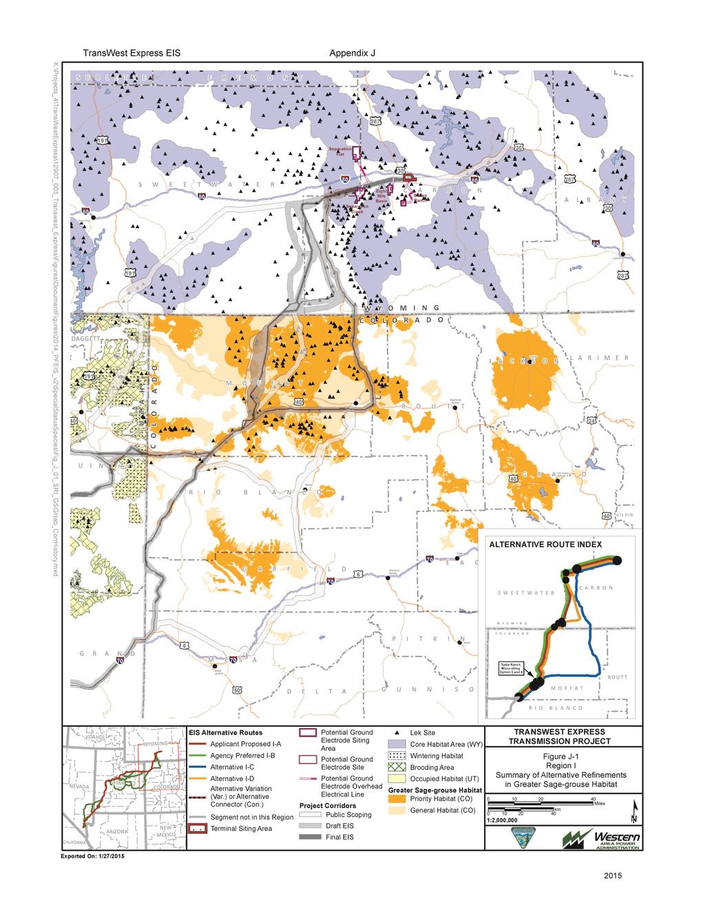
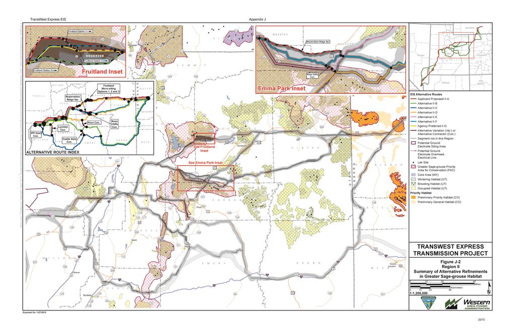
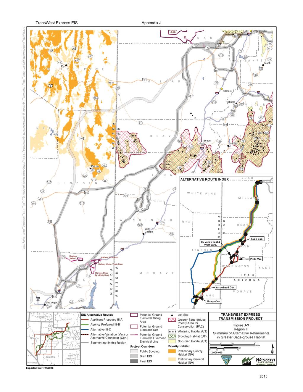
7 TransWest Express EIS Appendix J J-6 J.3 Project Coordination and Actions to Comply with Applicable Plans and Policies Greater sage-grouse and sage-grouse habitats are widespread in many of the landscapes crossed by the alternative routes in Wyoming, Colorado, and Utah. As the co-lead agencies, BLM and Western, in coordination with cooperating agencies, acknowledged that developing alternative routes that completely avoid greater sage-grouse and sage-grouse habitat would not be feasible. Agency collaboration with the Applicant to identify feasible strategies to avoid, minimize, and compensate for the potential effects of the Project on greater sage-grouse pursuant to the plans and policies described in Section J.2 has been ongoing throughout the development of the EIS. J.3.1 Avoidance of Greater Sage-grouse Habitat through Project Siting The co-lead agencies worked with the cooperating agencies and the Applicant to avoid and minimize potential effects on greater sage-grouse by identifying and eliminating or modifying alternative routes that would have substantially greater effects on sage-grouse or sage-grouse habitat compared to other alternative routes considered. J Routes Eliminated from Further Consideration Transmission line alternative routes and segments included in the Applicant s Application for Transportation and Utility Systems and Facilities on Federal Lands were systematically screened and analyzed using the methods described in EIS Section Alternative routes that would entail substantially higher impacts on sage-grouse and sage-grouse habitat compared to other alternative routes were eliminated from further consideration in the EIS. Alternative routes and segments that were eliminated from further consideration at least in part due to their impacts on sage-grouse and sage-grouse habitats include: Wyoming Segment 200 (Western Wyoming Alternative Variation) was removed because of multiple resources concerns including the level of potential impacts to the South Rock Springs Core management area. Colorado Segment 80, southwest of Baggs, Wyoming was removed at the request of the BLM Little Snake Field Office because of impacts to important greater-sage grouse populations. J Alignment Revisions and Local Route Variations The BLM, cooperating agencies, and the Applicant worked collaboratively to refine the alternative routes analyzed in the EIS, as practicable, to avoid or minimize effects on sage-grouse and important sage-grouse habitats. These refinements included local adjustments to the alternative routes to locate them outside of designated sage-grouse habitat or in habitats of lower value to sage-grouse and development of local route variations that would avoid important sage-grouse habitats. Segments that were refined and local route variations that were developed at least in part to reduce potential effects on sage-grouse and sage-grouse habitats include: Wyoming DEIS Segments 115, , , were added at the request of the BLM Rawlins Field Office to avoid impacts to sage grouse habitat. DEIS Segments 150 and 160 were added in response to scoping and cooperator comments and provide bi-directional crossover options among all three alternatives. The alternative
8 TransWest Express EIS Appendix J J-7 connector offers routing flexibility to avoid environmental issues expressed by the Western Resource Advocates and the Coalition of Local Governments. Colorado DEIS Segment 180 was shifted slightly to the east to avoid greater sage-grouse PPH and to address public preference for an alignment in the Sevenmile Ridge area. DEIS Segment 186 was added at the request of the BLM Little Snake River field office. Utah DEIS Segments 218, 219.1, 219.2, 219.3, 219.4, were developed to address BLM Utah concerns over greater sage-grouse habitat. J Alternative Corridor Refinement Throughout the development of the EIS, the co-lead agencies have collaborated with the applicant to refine the regional analysis corridors in order to avoid and minimize the potential for impacts to greater sage-grouse. Figures J-1, J-2, and J-3 (Exhibit J3) display the results of the corridor refinement process with regards to areas of occupied greater sage-grouse habitat potentially crossed by the Project. Table J-1 provides information on the various areas of greater sage-grouse habitat potentially crossed by the project during each phase of the EIS process. Table J-1 Summary of the Acreages of Greater Sage-grouse Habitats crossed by the Public Scoping, DEIS, and FEIS Analysis Corridors. Habitat Type Public Scoping Corridors (acres) Draft EIS Corridors (acres) Percent Change from Scoping Final EIS Corridors (acres) Percent Change from DEIS Wyoming Core 69,698 26, , Colorado PPH 193, , , Colorado PGH 152, , , Utah Occupied 196, , , Utah Brood-rearing 179, , , Utah Winter 146, , , J.3.2 Development of Offsite Mitigation Despite removing and modifying alternative routes and segments that would have comparatively higher impacts on sage-grouse and implementing additional onsite mitigation, the co-leads and cooperating agencies anticipate that implementation of any of the alternative routes analyzed in the EIS would result in residual impacts on sage-grouse and sage-grouse habitat (refer to EIS Section 3.8.6). The residual impacts would not be consistent with the objectives for sage-grouse and sage-grouse habitat management identified in applicable agency plans and policies (Section J.2). In accordance with BLM WO IM and other cooperating agency policies pertaining to offsite mitigation, BLM, the cooperating agencies, and the Applicant are working collaboratively to develop appropriate offsite mitigation that could be implemented to facilitate reasonable development of the Project consistent with applicable agency plans and policies pertaining to greater sage-grouse. To facilitate this collaboration, the Applicant has convened a group of sage-grouse biologists from the BLM and cooperating agencies (the Habitat Equivalency Analysis [HEA] Technical Advisory Group) to provide input and guidance for developing the Applicant s Sage-grouse Mitigation Plan, including the
9 TransWest Express EIS Appendix J J-8 HEA (refer to EIS Section 3.8.6). The methods used in development of the Applicant s Sage-grouse Mitigation Plan, including the HEA and the types of offsite mitigation being considered are described in the Project s Plan of Development (Appendix K, TransWest Express Transmission Project Greater Sage-grouse Mitigation Plan), which is attached to this EIS as Appendix D.
10 TransWest Express EIS Appendix J Exhibit J1
11 TransWest Express EIS Appendix J - Exhibit J1 Framework for Sage-grouse Impacts Analysis for the TransWest Express Transmission Project 2013 (1) Evaluation of Direct and Indirect Impacts - This portion of the overall Greater Sage- Grouse (hereafter sage-grouse) Impacts Assessment Framework addresses project-related habitat impacts that bear directly on listing factors considered by the U.S. Fish and Wildlife Service (FWS) when evaluating the need to provide full listing protection under the Endangered Species Act (ESA). A starting point for this analysis is a thorough review of the threats assessment/five factor analysis that FWS conducted as part of the March 23, 2010 (75 FR 13910), listing of the sagegrouse as a Candidate under ESA. An evaluation of all potential threats to sage-grouse and sage-grouse habitat from the transmission line should be conducted incorporating the latest available scientific information most of which is referenced in the FR notice itself. Of particular importance is the synthesis evaluation of all potential threats of the project that operate cumulatively to impact sage-grouse populations and habitat in a way that is not adequately evaluated by examining threats independently. The direct, indirect and cumulative impacts analysis for the project should consider the FR notice cumulative threats assessment summary as an example of how to fully analyze impacts associated with the proposed project. Reference to additional scientific information published since the issuance of the FR notice is available on the FWS website and should be incorporated into the analysis: all available scientific information should be used in the direct, indirect and cumulative impacts analysis. An analysis of sage-grouse populations that attend leks within 18km of the project is a critical component of an indirect impacts analysis for the species. Sage-grouse that attend leks up to 18km from the project may be indirectly affected by the loss of habitat functionality during other seasons of the year (Connelly et.al. 2000). The construction of a transmission project or other linear facility may pose additional hindrance of seasonal migration patterns or avoidance of important seasonal habitats once used extensively by local sage-grouse populations. Qualitative and quantitative measures of habitat change must be considered in describing the potential impacts of the project. In the context of managing a species that requires such a large landscape of habitats to meet their life-cycle needs, and the nature of the proposed disturbance, it is reasonable to make some assumptive predictions about the relative impacts within 18km. (2) Addressing Direct Loss of Birds - This piece of the overall Greater Sage-Grouse Impacts Assessment Framework is an important contribution to the rangewide jeopardy analysis conducted as part of the informal conferencing process for this Candidate species. Additionally, addressing impacts to populations provides key information needed for completing any potential future formal Section 7 consultation that would be required if the sage-grouse is ultimately listed under ESA during project development, thereby significantly streamlining this process. FWS is actively working on this issue as it relates to rangewide sage-grouse conservation. There are two ways that the project proponent is expected to help resolve this concern: 2015
12 TransWest Express EIS Appendix J - Exhibit J1 a) Work closely with FWS and State Agency Biologists to develop an approach to address loss of birds from project-related impacts and their replacement; b) Contribute financially to research projects that have been designed specifically to address this issue. (3) Mitigation - Until an impacts analysis has been conducted in coordination with agency biologists leading to an adequate understanding of impacts to sage-grouse populations and habitat the issue of mitigation will not be addressed. However, when discussion and evaluation of mitigation does begin, it is with the understanding that mitigation ratios across state lines will remain the same. That is, a bird in Wyoming is equivalent to one in Colorado or Utah; an acre of nesting habitat in Colorado is worth as much in Wyoming and Utah; etc. The Habitat Equivalency Analysis, described below, provides a standardized basis to determine a one-to-one ratio for habitat services lost/ habitat services mitigated. However, biological factors may provide a valid basis for adjusting the minimal mitigation ratio beyond one-to-one. Three such factors include: (a) the best available scientific information regarding the relative value of sage-grouse populations contributing to long-term species viability across the species range points to the relative importance of central and southwestern ID, central and northwestern NV, eastern OR, and the state of WY; (b) regarding individual birds, hens have a much higher biological value, in terms of contribution to populations, than males; and (c) localized habitats of high ecological value including (but not limited to) those serving key functions in demographic, genetic, or seasonal connectivity, important wintering areas, or leks. Habitat Equivalency Analysis (HEA) - HEA is a method of quantifying the permanent or interim loss of habitat services from project-related impacts. HEA provides a scientificbased, peer-reviewed method of scaling compensatory mitigation requirements, and has been used by federal regulatory agencies including the FWS and National Oceanic and Atmospheric Administration. The HEA is not meant to be an impacts analysis in and of itself; rather, it is a way to objectively determine quantity of project-related habitat impacts and provides the quantity and type of mitigation necessary to offset loss of habitat services as a form of output. HEA is a process that requires close collaboration among the project proponent and State Agencies in states sustaining most of the impacts to populations and habitat (Wyoming, Colorado, and Utah) as well as FWS and BLM biologists and local working groups to ensure adequacy of analysis and a corresponding final product. Building models associated with the HEA process must be done in close coordination with agency biologists and local working groups in order to address concerns, questions, assumptions, and issues as they arise. Agency biologists recognize the need for the incorporation of data and information the HEA models that the project proponent may not currently have. Agency biologists will work with project proponents to obtain such information to the extent they can (e.g., habitat maps; adequate vegetation data) again, reiterating the need for an interactive approach between 2015
13 TransWest Express EIS Appendix J - Exhibit J1 the project proponent and agency biologists in order to ensure adequate completion of the HEA. The initial starting point for evaluating direct and indirect impacts to sage-grouse habitat will be 18km either side of the proposed transmission line, addressing impacts to roughly 98% of nesting hens according the best available scientific information. Any deviation from this starting point must be supported by scientific literature: agency biologists can direct the project proponent to recently published literature on this topic which the project proponent is encouraged to use. 2015
14 TransWest Express EIS Appendix J - Exhibit J1 Calculating Density of Disturbance within Key Habitat Once the Alternatives Analysis is complete and a preferred alternative has been selected, an additional site-specific evaluation of density of disturbance within Key Habitats/Core Areas may be conducted. The purpose of this evaluation is to evaluate opportunities to: minimize density of disturbance within Key Habitats/Core Areas that are outside the designated disturbance corridor identified in the Wyoming Governor s Executive Order ; and restore and/or enhance important sage-grouse habitat as a part of project-related mitigation. These site-specific habitat evaluations also will enable BLM to: (a) demonstrate compliance with the Greater Sage-Grouse Habitat Management Policy on Wyoming BLM Administered Public Lands including Federal Mineral Estate (IM WY ); and (b) demonstrate consistency with the Greater Sage-Grouse Core Area Protection, Wyoming Governor s Executive Order In Colorado and Utah, if density disturbance calculations are completed, they will be closely coordinated with the appropriate State and Federal agencies to ensure that each state s Key Habitat areas are appropriately identified and considered in the Density Disturbance Calculation (DDC). The overall goal of a Sage-Grouse Key Habitat/Core Area Strategy is to limit the density and duration of disturbances and restrict activities within Key Habitats/Core Areas sufficient to ensure the long-term conservation and management of sage-grouse within each state. To this end, the DDC is a tool designed to measure habitat loss within the Key Habitat/Core Area. In particular, in Wyoming, it is used to determine in terms of management actions how the project-related disturbance can be limited to no more than 5% loss of habitat and result in no more than an average of one disturbance per 640 acres. Step 1: Determination of leks that will be used in the site-specific evaluation: Place a four-mile boundary around the outer project boundary (as defined by the proposed area of disturbance related to the project, i.e., Right of Way width, or similar). All occupied and undetermined sage-grouse leks located within four miles of the outer boundary of the project, and within Key Habitat/Core Areas, the will be considered in the DDC. Step 2: Determine the DDC area size and configuration: A four-mile boundary placed around the perimeter of each lek identified in Step 1 and the area within the boundary of the leks, plus the four-mile project boundary, creates the DDC area for the project. Step 3: Density of disturbance habitat evaluation: Disturbance will be evaluated for the DDC area as a whole, as well as for individual leks within the DDC area. Any portion of the DDC that falls outside Key Habitat/Core Area will be removed from this portion of the evaluation for Wyoming to maintain consistency with the provisions in Wyoming Executive Order Disturbance Calculation: Total acres of disturbance within the DDC area will be determined through an evaluation of: a. Existing and Proposed disturbance sage-grouse habitat that is disturbed by existing anthropogenic features or activities (e.g., transmission lines, distribution lines, wind 2015
15 TransWest Express EIS Appendix J - Exhibit J1 development, oil/gas wells/facilities, active mine areas, geothermal, communication towers, pipelines, paved and improved roads, and others) and wildfire, including the full ROW width of the proposed action; b. Approved permits (i.e., any state or Federal permits providing approval for on the ground actions) for projects not yet implemented or constructed. Habitat Disturbance Evaluation: In Wyoming, for projects that will result in disturbance of more than 5% of the DDC area, it may be advantageous for the project proponent to map the full extent of sage-grouse habitat within the DDC area in order to reduce this percentage. If this is done, it will be conducted to identify: a. Suitable Habitat and Marginal Habitat using BLM s Habitat Assessment Framework (HAF) and unsuitable habitats within the DDC area b. Sage-grouse evidence of use of suitable habitats (seasonal use, densities based on best available information) c. Priority restoration areas (which could reduce the existing disturbances to below the 5% threshold) for example: i) Areas where plug and abandon activities on retired oil and gas wells will eliminate disturbance ii) Areas where old reclamation has not produced suitable habitat d. Areas of invasive species e. Lands where other conservation assurances are in place (e.g., CCAA, easements, habitat contract, etc.) Step 4: Determination of existing and allowable suitable habitat disturbance: Acres of disturbance within suitable habitat divided by the total suitable habitat within the DDC area, multiplied by 100, equals the percent of disturbed suitable habitat within the DDC area. In Wyoming, subtracting the percentage of existing disturbed suitable habitat from 5% equals new allowable suitable habitat disturbance until plant regeneration or reclamation reduces acres of disturbed habitat within the DDC area. 2015
16 TransWest Express EIS Appendix J Exhibit J2 See the TransWest Express Transmission Project Plan of Development (Appendix K, Greater Sage-grouse Mitigation Plan) Attached as Final EIS Appendix D
17 TransWest Express EIS Appendix J Exhibit J3 (Figures)
18
19
20
UNITED STATES DEPARTMENT OF THE INTERIOR BUREAU OF LAND MANAGEMENT Washington, DC
 UNITED STATES DEPARTMENT OF THE INTERIOR BUREAU OF LAND MANAGEMENT Washington, DC 20240-0002 http://www.blm.gov In Reply Refer to: 1610, 1734, 4100, 4180, 6700 (230) P EMS TRANSMISSION Instruction Memorandum
Notice of Availability of the Final Environmental Impact Statement for the Monument
 This document is scheduled to be published in the Federal Register on 06/24/2016 and available online at http://federalregister.gov/a/2016-15023, and on FDsys.gov 4310-DQ-P DEPARTMENT OF THE INTERIOR Bureau
3-13 Other Required Findings and Regulatory Compliance
 Affected Environment and Environmental Consequences 3-13 Other Required Findings and Regulatory Compliance 3-13.1 Short-term Uses and Long-term Productivity NEPA requires consideration of the relationship
Miles City Field Office Draft Resource Management Plan and Environmental Impact Statement
 Miles City Field Office Draft Resource Management Plan and Environmental Impact Statement Sage-Grouse Conservation Issue Priority Sage-Grouse Habitat Greater Sage-grouse are a landscape species (Connelly
Greater Sage-grouse Record of Decision
 United States Forest Department of Service Agriculture Greater Sage-grouse Record of Decision Northwest Colorado Wyoming In accordance with Federal civil rights law and U.S. Department of Agriculture (USDA)
Wind Energy Development Specialist Report
 United States Department of Agriculture Forest Service Southwestern Region Cibola National Forest and National Grasslands Wind Energy Development Specialist Report Kiowa, Rita Blanca, Black Kettle and
Proposed Plan High Level Overview
 Introduction Navigating the Document Key Appendices Proposed Plan Primary Threats in Oregon Addressing Threats Mitigation Strategy Adaptive Management Strategy Next Steps Questions Proposed Plan High Level
U.S. DEPARTMENT OF THE INTERIOR FISH AND WILDLIFE SERVICE OKLAHOMA ECOLOGICAL SERVICES FIELD OFFICE
 U.S. DEPARTMENT OF THE INTERIOR FISH AND WILDLIFE SERVICE OKLAHOMA ECOLOGICAL SERVICES FIELD OFFICE May 11, 2009 STANDARD RECOMMENDATIONS TO AVOID, MINIMIZE AND MITIGATE POTENTIAL IMPACTS OF WIND ENERGY
Fisheries and Oceans Canada Species at Risk Act. Directive on the Identification of Critical Habitat for Aquatic Species at Risk
 Fisheries and Oceans Canada Species at Risk Act Directive on the Identification of Critical Habitat for Aquatic Species at Risk January 2015 Species at Risk Program Programme d espèces en péril To be read
BLM-MOU-WO
 Appendix A. MEMORANDUM OF UNDERSTANDING BETWEEN THE DEPARTMENT OF AGRICULTURE NATURAL RESOURCES CONSERVATION SERVICE AND THE DEPARTMENT OF THE INTERIOR BUREAU OF LAND MANAGEMENT AND THE DEPARTMENT OF AGRICULTURE
Chapter 13: Wildlife and Vegetation
 Chapter 13: Wildlife and Vegetation Introduction and Setting Nevada County contains an extremely wide range of plants, animals and habitat types. With topographic elevations ranging from 300 feet in the
Master Development Plans (MDPs) / Geographic Area Plans (GAPS)
 / Geographic Area Plans (GAPS)") Master Development Plans (MDPs) / Geographic Area Plans (GAPS) COMPREHENSIVE PLANNING TOOLS FOR OIL AND GAS PROJECTS BUREAU OF LAND MANAGEMENT COLORADO RIVER VALLEY FIELD OFFICE (CRVFO) SILT, COLORADO
Master Development Plans (MDPs) / Geographic Area Plans (GAPS) COMPREHENSIVE PLANNING TOOLS FOR OIL AND GAS PROJECTS BUREAU OF LAND MANAGEMENT COLORADO RIVER VALLEY FIELD OFFICE (CRVFO) SILT, COLORADO
The Next Generation of Mitigation: Linking Current and Future Mitigation Programs with State Wildlife Action Plans and Other State and Regional Plans
 : Linking Current and Future Mitigation Programs with State Wildlife Action Plans and Other State and Regional Plans August 4, 2009 Jessica B. Wilkinson, James M. McElfish, Jr., and Rebecca Kihslinger
Description of Proposed Project
 Description of Proposed Project Introduction The County of Inyo (County) is proposing to update its General Plan to include policies for solar energy development within the County. The proposed Renewable
Proposed Action: In response to resource specialist concerns raised during internal scoping, the following restrictions will apply:
 DECISION MEMO USDA Forest Service Inyan Kara Riders Motorcycle Enduro Event Rocky Mountain Region Thunder Basin National Grassland Medicine Bow-Routt National Forests Douglas Ranger District April 2011
Siting Guidelines for Windpower Projects in Kansas
 Siting Guidelines for Windpower Projects in Kansas The Kansas Renewable Energy Working Group Environmental and Siting Committee Introduction The Environmental and Siting Committee of the Kansas Renewable
Industry Innovation Reduces Impacts on Sage-Grouse and Big Game
 Gaining Ground Industry Innovation Reduces Impacts on Sage-Grouse and Big Game The oil and natural gas industry over the past five years has undergone transformation with the rise of the shale revolution.
Long-term Management Plan For The Mitigation Bank
 Note: The California multi-agency Project Delivery Team developed this general outline to assist in the development of the Long-term Management Plan for mitigation banks. Objectives and tasks are provided
Executive Summary for the Record of Decision
 for the Record of Decision for the Record of Decision for the Land Use Plan Amendment to the California Desert Conservation Plan, Bishop Resource Management Plan, and Bakersfield Resource Management Plan
PLANT AND ANIMAL DIVERSITY
 by the planning rule team as of. These ideas are for discussion purposes and do not What we want to achieve PLANT AND ANIMAL DIVERSITY The Forest Service is committed to protecting species and sustaining
It s Cool to Be Safe
 USDA Forest Service San Juan National Forest http://www.fs.fed.us/r2/sanjuan San Juan Public Lands Center 15 Burnett Court Durango, CO 81301 Ph (970) 247-4874 Fax (970) 385-1243 USDI Bureau of Land Management
DETAILED IMPACT ANALYSIS OF MARMOT BASIN LONG RANGE PLAN
 2.0 JURISDICTION Parks Canada s decisions about the acceptability of proposals presented in the LRP are guided by a number of regulatory instruments and policies, the most relevant of which are described
Public Notice. Applicant: City of Dallas Project No.: SWF Date: April 18, Name: Chandler Peter Phone Number:
 Public Notice Applicant: City of Dallas Project No.: SWF- 2014-00151 Date: April 18, 2014 The purpose of this public notice is to inform you of a proposal for work in which you might be interested. It
Chapter 1 Purpose and Need
 Chapter 1 Purpose and Need CHAPTER 1 PURPOSE AND NEED 1.1 Introduction This document, the Environmental Impact Statement (EIS) and Land-use Plan Amendments (LUPAs), is being prepared in response to an
Natural Gas Development and Wildlife Mitigation A PRIMER THE MITIGATION INITIATIVE
 Natural Gas Development and Wildlife Mitigation A PRIMER THE MITIGATION INITIATIVE Environment and Natural Resources Mission Statement The mission of the UW Environment and Natural Resources (ENR) program
Preparing a Community Wildfire Protection Plan
 Preparing a Community Wildfire Protection Plan A Handbook for Wildland Urban Interface Communities Sponsored By: Communities Committee National Association of Counties National Association of State Foresters
Early Scoping for Proposed Application for Incidental Take Permit and Habitat
 This document is scheduled to be published in the Federal Register on 11/12/2013 and available online at http://federalregister.gov/a/2013-26950, and on FDsys.gov Billing Code 4310 55 DEPARTMENT OF THE
Economic Impacts of Sage Grouse Management: Supplemental Report
 Economic Impacts of Sage Grouse Management: Supplemental Report Piceance Basin Development Analysis Prepared for Garfield County Community Development Department 108 8 th Street, Suite 401 Glenwood Springs,
Nestlé Waters North America Inc. Special Use Permit San Bernardino National Forest Project Proposal
 Nestlé Waters North America Inc. Special Use Permit San Bernardino National Forest Project Proposal 1. Introduction This document describes the project proposal for the short term (5 year) authorization
Understanding the State Planning Policy July 2017 Changes to state interest statements, policies and assessment benchmarks
 Understanding the State Planning Policy July 2017 Changes to state statements, policies and assessment benchmarks This fact sheet outlines the key policy changes to the state statements, policies and assessment
Overview of the Habitat Conservation Plan
 Overview of the Habitat Conservation Plan June 27, 2007 The Relationship between HCPs and Incidental Take Permits (ITP) A habitat conservation plan or HCP must accompany an application for an incidental
TROPIC TO HATCH 138 kv TRANSMISSION LINE
 TROPIC TO HATCH 138 kv TRANSMISSION LINE U.S. Department of Agriculture Forest Service Intermountain Region Dixie National Forest April 2011 The U.S. Department of Agriculture (USDA) prohibits discrimination
DECISION MEMO. West Fork Blacktail Deer Creek Hardened Crossing
 Page 1 of 6 Background DECISION MEMO USDA Forest Service Madison Ranger District Madison County T12S, R4W, Section 30 The project is in the Gravelly Landscape, Snowcrest Recommended Wilderness Management
Wildlife Conservation Strategy
 Wildlife Conservation Strategy Boise National Forest What is the Wildlife Conservation Strategy? The Boise National Forest is developing a Wildlife Conservation Strategy (WCS) in accordance with its Land
PRESCRIBED FIRE IN SOUTHWEST IDAHO
 2016 PRESCRIBED FIRE IN SOUTHWEST IDAHO In southwest Idaho, public land managers work to: address public health and safety concerns; treat insect and disease infestations; reduce the risk of severe wildfires
Blanche Park Reservoir Decision Notice and Finding of No Significant Impact
 Blanche Park Reservoir Decision Notice and Finding of No Significant Impact U.S. Forest Service Grand Mesa, Uncompahgre, and Gunnison National Forests Delta County, Colorado INTRODUCTION The Grand Mesa
MEMORANDUM OF UNDERSTANDING AMONG:
 MEMORANDUM OF UNDERSTANDING AMONG: U.S. FISH AND WILDLIFE SERVICE U.S. ARMY AT FORT BRAGG U.S. ARMY ENVIRONMENTAL COMMAND NORTH CAROLINA WILDLIFE RESOURCES COMMISSION NORTH CAROLINA DEPARTMENT OF ENVIRONMENT
LAND DEVELOPMENT AND PLANNING FORUM 2014 THE 2014 PROVINCIAL POLICY STATEMENT AND ENVIRONMENTAL PROTECTION
 LAND DEVELOPMENT AND PLANNING FORUM 2014 THE 2014 PROVINCIAL POLICY STATEMENT AND ENVIRONMENTAL PROTECTION MARY L. FLYNN-GUGLIETTI AND ANNIK FORRISTAL THE 2014 PROVINCIAL POLICY STATEMENT & ENVIRONMENTAL
PROPOSED ACTION Cooperative Horse Removal with Fort McDermitt Paiute-Shoshone Tribe
 PROPOSED ACTION Cooperative Horse Removal with Fort McDermitt Paiute-Shoshone Tribe Proposed Action The Santa Rosa Ranger District of the Humboldt-Toiyabe National Forest is proposing to remove all unauthorized
WATERSHED MANAGEMENT INITIATIVE: GOALS & IMPLEMENTATION OBJECTIVES, JULY 26, 1999
 WATERSHED MANAGEMENT INITIATIVE: GOALS & IMPLEMENTATION OBJECTIVES, JULY 26, 1999 The following table indicates the draft goals and objectives for the Santa Clara Basin WMI process. The overall objectives
Draft Decision Notice Maroon Bells - Snowmass Wilderness Overnight Visitor Use Management Plan
 Draft Decision Notice Maroon Bells - Snowmass Wilderness Overnight Visitor Use Management Plan USDA Forest Service Aspen-Sopris Ranger District, White River National Forest Gunnison Ranger District, Grand
Pacific Northwest Region, Forest Service Basin-scale Restoration Prioritization Process
 Pacific Northwest Region, Forest Service Basin-scale Restoration Prioritization Process Pacific Northwest Region U.S.D.A. Forest Service Dave Heller, Regional Fish Program Leader Bruce McCammon, Regional
Species at Risk Act Permitting Policy
 PROPOSED Species at Risk Act Policies and Guidelines Series Species at Risk Act Policies Species at Risk Act Permitting Policy 2016 Recommended citation: Government of Canada. Species at Risk Act Permitting
C&B Alberta Solar Development ULC
 Decision 22781-D01-2017 Newell Solar Power Plant November 15, 2017 Alberta Utilities Commission Decision 22781-D01-2017 Newell Solar Power Plant Proceeding 22781 Application 22781-A001 November 15, 2017
County of Calaveras Department of Planning
 Date: July 18, 2013 To: From: Project: Advisory Agencies Amy Augustine, AICP - Planner County of Calaveras Department of Planning Rebecca L. Willis, AICP ~ Planning Director Phone (209) 754-6394 Fax (209)
SBEADMR Priority Treatment Areas Process and Results
 SBEADMR Priority Treatment Areas Process and Results GIS Optimization & Interdisciplinary Validation, September & October 2015 Purpose Use GIS to focus and prioritize potential treatment areas within the
October 13, Dear Interior Secretary Mr. Zinke,
 October 13, 2017 The Honorable Ryan K. Zinke Secretary of the Interior United States Department of the Interior 1849 C Street, NW Room 6612 Washington, DC 20240 Dear Interior Secretary Mr. Zinke, The purpose
The province has been divided into six Fire Management Zones based on common management objectives, land use, fire load, and forest ecology.
 Appendix A: Fire Management Zones & Zone Specific Direction The province has been divided into six Fire Management Zones based on common management objectives, land use, fire load, and forest ecology.
Decision Memo Tongass National Forest. Wrangell Ranger District. Pre-Commercial Thinning CE 2010
 Decision Memo Tongass National Forest Pre-Commercial Thinning CE 2010 Decision It is my decision to authorize pre-commercial thinning (PCT) on approximately 7,500 acres of overstocked young-growth forest
California High-Speed Train Program FEIR/EIS
 Page 2-30 Page 2-31 Page 2-32 Page 2-33 Page 2-34 Page 2-35 Page 2-36 of Enrique Manzanilla, Director U.S. Environmental Protection Agency, August 31, 2004 (Letter AF008) AF008-1 Acknowledged. AF008-2
Operational Policy Statement
 Operational Policy Statement Determining Whether a Designated Project is Likely to Cause Significant Adverse Environmental Effects under the Canadian Environmental Assessment Act, 2012 November 2015 i
DRECP DESERT RENEWABLE ENERGY CONSERVATION PLAN
 DRECP DESERT RENEWABLE ENERGY CONSERVATION PLAN PROPOSED LAND USE PLAN AMENDMENT AND FINAL ENVIRONMENTAL IMPACT STATEMENT Executive Summary October 2015 2 DRECP PROPOSED LUPA AND FINAL EIS TABLE OF CONTENTS
Appendix 1: Forest Carbon Emission Offset Project Development Guidance
 The Ministry of Forests, Lands and Natural Resource Operations (FLNRO) supports the use of forest carbon management options that satisfy the diverse values that British Columbians seek from their forests.
Regulatory Guidance Letter 93-02
 Regulatory Guidance Letter 93-02 SUBJECT: Guidance on Flexibility of the 404(b)(1) Guidelines and Mitigation Banking DATE: August 23, 1993 EXPIRES: December 31, 1998 1. Enclosed are two guidance documents
Environmental Guidelines Checklist
 Environmental Guidelines Checklist Stakeholder: Alberta Environment & Parks (Brian Lambert), AltaLink, ATCO Electric, EPCOR Distribution & Transmission (EDTI) Section Subsection Existing Proposed changes
Seventh Northwest Conservation and Electric Power Plan
 Seventh Northwest Conservation and Electric Power Plan CHAPTER 19: METHODOLOGY FOR DETERMINING QUANTIFIABLE ENVIRONMENTAL COSTS AND BENEFITS AND DUE CONSIDERATION FOR ENVIRONMENTAL QUALITY, FISH AND WILDLIFE,
Central Oregon Cohesive Strategy Initiative
 Central Oregon Cohesive Strategy Initiative Background and Concept September 2015 The National Cohesive Wildland Fire Management Strategy The Federal Land Assistance, Management and Enhancement Act (FLAME)
Tahoe Basin Climate Action Database Guidance Memo
 Tahoe Basin Climate Action Database Guidance Memo US Army Corps of Engineers Climate Change Project Date: 2/11/2011 CONTE NTS Purpose & Use 1 Users & Roles 1 Implementing Entity Staff 1 Implementing Entity
DECISION NOTICE FINDING OF NO SIGNIFICANT IMPACT (FONSI)
") DECISION NOTICE AND FINDING OF NO SIGNIFICANT IMPACT (FONSI) FOR CASA LOMA RECREATION RESIDENCE PERMIT RENEWAL U.S. FOREST SERVICE CIBOLA NATIONAL FOREST SANDIA RANGER DISTRICT BERNALILLO COUNTY, NEW MEXICO
DECISION NOTICE AND FINDING OF NO SIGNIFICANT IMPACT (FONSI) FOR CASA LOMA RECREATION RESIDENCE PERMIT RENEWAL U.S. FOREST SERVICE CIBOLA NATIONAL FOREST SANDIA RANGER DISTRICT BERNALILLO COUNTY, NEW MEXICO
3.1 Forest Vegetation and Wildlife Habitat
 3.1 Forest Vegetation Echo Trail Area Forest Management Project Forest vegetation and wildlife habitat analyses are based on data contained in a Region 9 program referred to as CDS (Combined Data System).
Bureau of Land Management Oil and Gas Program
 Bureau of Land Management Oil and Gas Program Presentation to the Production Accountants Society of Oklahoma Steve Tryon, Field Manager February 6, 2013 The Bureau of Land Management (BLM) is a small agency
WEST TAVAPUTS PLATEAU NATURAL GAS FULL FIELD DEVELOPMENT PLAN RECORD OF DECISION
 WEST TAVAPUTS PLATEAU NATURAL GAS FULL FIELD DEVELOPMENT PLAN RECORD OF DECISION July 2010 Prepared by: U.S. Department of the Interior Bureau of Land Management Price Field Office Price, Utah Cooperating
Energy HOT TOPICS on Public Lands at the End of the Obama Era Energy Mineral Law Foundation June, 2015
 Energy HOT TOPICS on Public Lands at the End of the Obama Era Energy Mineral Law Foundation June, 2015 Rebecca Watson Welborn Sullivan Meck & Tooley P.C. Denver, Colorado rwatson@wsmtlaw.com 2 Introduction:
ENVIRONMENT ACT TERMS OF REFERENCE NOVA SCOTIA DEPARTMENT OF TRANSPORTATION AND PUBLIC WORKS. Beaver Bank Bypass
 ENVIRONMENT ACT TERMS OF REFERENCE NOVA SCOTIA DEPARTMENT OF TRANSPORTATION AND PUBLIC WORKS Beaver Bank Bypass Highway 101 to the Beaver Bank Road Halifax County, NS NOVA SCOTIA DEPARTMENT OF THE ENVIRONMENT
Office of Surface Mining Reclamation and Enforcement
 This document is scheduled to be published in the Federal Register on 01/03/2018 and available online at https://federalregister.gov/d/2017-28407, and on FDsys.gov 4310-05-P DEPARTMENT OF THE INTERIOR
Chapter 10 Natural Environment
 Chapter 10 Natural Environment Existing Conditions The Natural Environment Element addresses the protection, conservation, preservation, and restoration of the natural resources the Bayview Ridge Subarea,
SAN LUIS VALLEY PUBLIC LANDS CENTER
 Decision Notice And Finding of No Significant Impact Watershed and Fisheries Conservation Treatments SAN LUIS VALLEY PUBLIC LANDS CENTER USDA Forest Service Rocky Mountain Region Public Lands Center Rio
The Next Generation of Mitigation: Linking Current and Future Mitigation Programs with State Wildlife Action Plans and Other State and Regional Plans
 The Next Generation of Mitigation: Linking Current and Future Mitigation Programs with State Wildlife Action Plans and Other State and Regional Plans August 4, 2009 Jessica B. Wilkinson, James M. McElfish,
Decision Notice and Finding of No Significant Impact
 Decision Notice and Finding of No Significant Impact Gold Lake Bog Research Natural Area Boundary Adjustment and Nonsignificant Forest Plan Amendment #53 USDA Forest Service Middle Fork Ranger District,
Instructions for the South Pacific Division Nationwide Permit Pre- Construction Notification (PCN):
:") This PCN integrates the requirements of the U.S. Army Corps of Engineers (Corps) Nationwide Permit Program within the South Pacific Division (SPD), including the Albuquerque, Los Angeles, San Francisco,
This PCN integrates the requirements of the U.S. Army Corps of Engineers (Corps) Nationwide Permit Program within the South Pacific Division (SPD), including the Albuquerque, Los Angeles, San Francisco,
Characterization of montane ecosystems, their microclimates, and wildlife distribution and abundance across the hydrographic Great Basin
 Characterization of montane ecosystems, their microclimates, and wildlife distribution and abundance across the hydrographic Great Basin This project retrieves four years of data from over 200 temperature
Calculating Mitigation
 US Army Corps of Engineers Jacksonville District Calculating Mitigation Lift Loss 1 US Army Corps of Engineers Jacksonville District Under the U.S. Army Corps of Engineers Regulatory Program, mitigation
Natural Resource Management of Pipeline Infrastructure
 Natural Resource Management of Pipeline Infrastructure Dan Devlin Director, Bureau of Forestry www.dcnr.state.pa.us Connection between Pipelines & DCNR Commonwealth s forests Fragmentation or reduction
GENERAL GUIDELINES FOR CONDUCTING THREATENED AND ENDANGERED SPECIES SURVEYS IN THE PINELANDS AREA. March 25, 2006 INTRODUCTION
 GENERAL GUIDELINES FOR CONDUCTING THREATENED AND ENDANGERED SPECIES SURVEYS IN THE PINELANDS AREA March 25, 2006 INTRODUCTION This document is intended to provide general guidance for use in conducting
Notice No Closing Date: May 12, 2017
 Public Notice U.S. Army Corps of Engineers Pittsburgh District In Reply Refer to Notice No. below US Army Corps of Engineers, Pittsburgh District 1000 Liberty Avenue Pittsburgh, PA 15222-4186 Application
Employment Opportunity: Botany Field Crew Needed in the USFS's Spring Mountains near Las Vegas, NV
 Employment Opportunity: Botany Field Crew Needed in the USFS's Spring Mountains near Las Vegas, NV *Botany Field Team Lead: * 6- RAP- 060 *Botany Field Technician:* 6- RAP- 059 *Botany Field Team Lead*
A full description of the lesser prairie chicken model and its intended uses is found in:
 The following is a description of factors used to develop a spatial model for greater prairie chickens (GRPC) in northeastern Oklahoma and adjacent areas of Kansas, Missouri, and Arkansas, and a voluntary
LCC Council Charter. Introduction
 LCC Council Charter Introduction North American, Pacific, and Caribbean landscapes, islands, and seascapes represent some of the most beautiful and iconic places on earth. These places are vital for our
WETLANDS AND OPEN WATERS Compensatory Mitigation Definitions of Factors
 Adverse effects as used in this section of the SOP means any adverse ecological effect on wetlands or areas of open water. Those effects, or impacts, include filling, excavating, flooding, draining, clearing,
Chapter 1. Purpose and Need
 Chapter 1. Purpose and Need 1.1 Purpose and Need for the Plan The purpose of this planning effort is to develop a Proposed Resource Management Plan (PRMP) that will provide overall management and long-term
Environmental Setting, Impacts, and Mitigation Measures
 First page header CHAPTER 4 Environmental Setting, Impacts, and Mitigation Measures 4.0 INTRODUCTION TO THE ENVIRONMENTAL ANALYSIS Sections 4.1 through 4.13 of Chapter 4 of this EIR contain a discussion
Guidelines for the Closure and Reclamation of Advanced Mineral Exploration and Mine Sites in the Northwest Territories
 DRAFT Guidelines for the Closure and Reclamation of Advanced Mineral Exploration and Mine Sites in the Northwest Territories Preface... 5 Introduction... 7 Purpose... 7 Authority... 7 How These Guidelines
NOTICE OF PREPARATION
 NOTICE OF PREPARATION Date: June 12, 2014 To: From: Subject: Governor s Office of Planning and Research/State Clearinghouse Unit, Responsible Agencies, Trustee Agencies, and Interested Parties Announcement
Sagebrush Country and Oil and Gas Country Can Coexist
 A Voice for the Western Majority Sagebrush Country and Oil and Gas Country Can Coexist In recent months, communities, businesses and elected officials throughout the West have collaborated in an unprecedented
Overview of Recent Developments in California Environmental Laws
 Overview of Recent Developments in California Environmental Laws Northwest Hydropower Conference March, 2009 James M. Lynch, Partner K&L Gates LLP (206) 370-6587 jim.lynch@klgates.com FERC Licensed Hydropower
Webinar: Mitigating Adverse Impacts on National Forests and Grasslands
 Webinar: Mitigating Adverse Impacts on National Forests and Grasslands Wednesday 6 April 2016 Transcript CHRIS CARLSON Good afternoon. This is Chris Carlson, I am the acting mitigation coordinator for
Acres 32% 35% Not Suitable. Impervious. Possible UTC. Vegetation. Existing UTC
 Acres A Report on Washington, D.C. s Urban Tree Canopy Why is Tree Canopy Important? Urban tree canopy (UTC) is the layer of leaves, branches, and stems of trees that cover the ground when viewed from
Introduction. Methodology for Analysis
 1 Medicine Lake Caldera Vegetation Treatment Project Scenic Report Prepared by: /s/gary Kedish Natural Resources Specialist for: Big Valley and Doublehead Ranger Districts Modoc National Forest February
2.1 Summary of Existing and Future Population Estimates
 SECTION 2 Demographics This technical memorandum identifies the uncertainties and describes potential future demographics that might affect wastewater facilities in the City of McCall, Idaho (the City).
2. Project Justification and Feasible Alternatives
 2. Project Justification and Feasible Alternatives 2.1 Project Justification Energy intensive industries associated with the coal and gas sectors in the Surat region continue to drive electricity demand
Northern Rockies Lynx Management Direction Record of Decision
 USDA Forest Service National Forests in Montana, and parts of Idaho, Wyoming, and Utah March 2007 Northern Rockies Lynx Management Direction Record of Decision The United States Department of Agriculture
Public Notice. Applicant: Lennar Homes Project No.: SWF Date: October 29, Name: Mr. Darvin Messer Phone Number:
 Public Notice Applicant: Lennar Homes Project No.: SWF-2013-00265 Date: October 29, 2013 The purpose of this public notice is to inform you of a proposal for work in which you might be interested. It is
Chapter 3 Affected Environment and Environmental Consequences
 Sterling Highway MP 45 60 Draft SEIS and Draft Section 4(f) Evaluation Chapter 3 Affected Environment and Environmental Consequences Prepared for: Alaska Department of Transportation and Public Facilities
DECISION NOTICE AND FINDING OF No SIGNIFICANT IMPACT HOPKINS FIRE SALVAGE
 DECISION NOTICE AND FINDING OF No SIGNIFICANT IMPACT HOPKINS FIRE SALVAGE DECISION U.S. FOREST SERVICE OCALA NATIONAL FOREST SEMINOLE RANGER DISTRICT MARION COUNTY, FLORIDA Based upon my review of the
COST-BENEFIT ANALYSIS. Categorical Exclusions for Oil and Gas Exploration and Development Activities. USDA Forest Service
 December 7, 2005 COST-BENEFIT ANALYSIS Categorical Exclusions for Oil and Gas Exploration and Development Activities USDA Forest Service COST-BENEFIT ANALYSIS Categorical Exclusions for Oil and Gas Exploration
J O I N T P U B L I C N O T I C E
 J O I N T P U B L I C N O T I C E CHARLESTON DISTRICT, CORPS OF ENGINEERS 69A Hagood Avenue Charleston, South Carolina 29403-5107 and the S.C. DEPARTMENT OF HEALTH AND ENVIRONMENTAL CONTROL Office of Environmental
PUBLIC NOTICE. REPLY TO: Denver Regulatory Office 9307 South Wadsworth Blvd 30 DAY NOTICE Littleton, CO FAX (303)
") PUBLIC NOTICE US Army Corps of Engineers Omaha District Application No: NWO-2017-01366-DEN Project: Douglas Lane Tributary Stabilization Project Applicant: Town of Castle Rock Waterway: Douglas Lane Tributary
PUBLIC NOTICE US Army Corps of Engineers Omaha District Application No: NWO-2017-01366-DEN Project: Douglas Lane Tributary Stabilization Project Applicant: Town of Castle Rock Waterway: Douglas Lane Tributary
Record of Decision. South Unit Oil and Gas Development Final Environmental Impact Statement
 United States Department of Agriculture Forest Service February 2012 Record of Decision South Unit Oil and Gas Development Final Environmental Impact Statement Duchesne Ranger District, Ashley National
Species at Risk Act Policies and Guideline Series
 Species at Risk Act Policies and Guideline Series Addressing Species at Risk Act Considerations Under the Canadian Environmental Assessment Act for Species Under the Responsibility of the Minister responsible
Draft Decision Notice and Finding of No Significant Impact (DN/FONSI)
") United States Department of Agriculture Forest Service January 2016 Draft Decision Notice and Finding of No Significant Impact (DN/FONSI) Rock Creek Vegetation and Fuels Healthy Forest Restoration Act
United States Department of Agriculture Forest Service January 2016 Draft Decision Notice and Finding of No Significant Impact (DN/FONSI) Rock Creek Vegetation and Fuels Healthy Forest Restoration Act