REPORT. Mayor Bonnette and Members of Council. Curtis Marshall, Sr. Planner - Policy
|
|
|
- Harvey Preston
- 5 years ago
- Views:
Transcription

1 REPORT REPORT TO: REPORT FROM: Mayor Bonnette and Members of Council Curtis Marshall, Sr. Planner - Policy DATE: January 2, 2015 REPORT NO.: RE: PDS Premier Gateway Phase 1B Employment Area Integrated Planning Project - Terms of Reference RECOMMENDATION: THAT Report PDS dated January 2, 2015, regarding the Premier Gateway Phase 1B Employment Area Integrated Planning Project - Terms of Reference be received; AND FURTHER THAT the Premier Gateway Phase 1B Employment Area Integrated Planning Project - Terms of Reference attached as Schedule 2 to this report be approved; AND FURTHER THAT the Manager of Purchasing be authorized to release a Request for Proposal consistent with the Terms of Reference set out in this report; AND FURTHER THAT staff report back to Council on the results of the Project Consultant selection process; AND FURTHER THAT a Steering Committee comprised of Members of Council, Town and Regional Planning Staff, members of the public, and a landowner(s) in the study area be established to provide input into the Premier Gateway Phase 1B Employment Area Integrated Planning Project.
2 PURPOSE: The purpose of this report is to: Present proposed Terms of Reference for the Premier Gateway Phase 1B Employment Area Integrated Planning Project to Council for consideration; Obtain Council approval of the Terms of Reference, and direction to issue a Request for Proposals to retain a qualified consultant team to undertake the project. Obtain Council approval to establish a Steering Committee for the project. BACKGROUND: Need for Project/Study As part of the Town s Capital Budget, $650,000 is approved and allocated for the undertaking of the Premier Gateway Phase 1B Employment Area Integrated Planning Project. The purpose of the project is: To develop appropriate land use designations and policies for the Phase 1B Employment Area. To identify up to 75 ha of additional land to be designated for employment and added to the area to replace the shortfall of employment lands to the the 2021 planning horizon in the Town. PLANNING CONTEXT: Sustainable Halton (ROPA 38) Implementation With the completion of the Sustainable Halton Process (the Region of Halton s growth management exercise) and the approval of Regional Official Plan Amendment 38 (ROPA 38) an additional 340 gross hectares (840 acres) of employment lands were designated for development in the Town of Halton Hills (on the north side of Steeles Avenue adjacent to the Premier Gateway Employment Area) to accommodate employment land needs for the 2021 to 2031 planning horizon. Through ROPA 38, this land was added to the Urban Area in the Regional Plan and identified to be serviced with municipal water and sewer. The Town s implementing Official Plan Amendment for Sustainable Halton and ROPA 38, Official Plan Amendment 10 (pending Regional approval), proposes to add the additional 340 gross hectares of land to the Town s Urban Area and designate the land for employment uses as Employment Area. OPA 10 sets out a framework to guide Secondary Planning exercises for the lands that will determine specific land use designations and policies. Page 2
3 GTA West/HPBATS Corridor Protection In June 2014, the Region of Halton adopted ROPA 43 to implement a corridor protection area and policies to protect for the Halton Peel Boundary Area Transportation Study/Greater Toronto Area West Corridor Study Area from development through the Town of Halton Hills and Milton to allow for the completion of the GTA West Corridor Environmental Assessment (EA) study being undertaken by the Ministry of Transportation. The amendment also re-phased certain employment lands in the Town of Halton Hills that were affected by corridor protection. Following the adoption of ROPA 43, Council for the Town of Halton Hills approved Official Plan Amendment 21 (OPA 21) on July 7, 2014 (Report PDS ) to implement corridor protection for the future GTA West Highway and Halton Peel Boundary Area Transportation Study (HPBATS) transportation improvements at the local level within the Town. The Corridor Protection Area Overlay freezes new development on all lands east of the Toronto Premium Outlets within the Town s Premier Gateway (401/407 Corridor) Employment Area. These lands will now be unavailable for development until the GTA West EA process is completed and it is determined what lands are/are not required for the transportation corridor. It is also anticipated that a significant amount of this area will be permanently precluded from development in order to accommodate a large highway interchange. The Ministry of Transportation (MTO) has advised that a preferred route will be recommended and taken to the public for their input by the end of Once the corridor is finalized, the MTO has indicated that areas not needed for the corridor can be removed from corridor protection. Premier Gateway Employment Lands Re-phasing As a result of the introduction of corridor protection (through ROPA 43 and OPA 21), and the re-phasing of employment lands by the Region of Halton (through ROPA 43) the Town is taking steps to re-phase the employment lands in the Premier Gateway Employment Area. This re-phasing will be accomplished through proposed modifications to OPA 10 as set out in Report PDS and endorsed by Council on July 7, The proposed modifications are as follows: Re-phasing the designated employment lands within the Future Employment Area which are outside of the GTA West Route Planning Study Area (north side of Steeles Ave., west of the Eighth Line), from the 2021 to 2031 planning horizon to the current 2021 planning horizon to replace the lands frozen to development by the Corridor Protection Area Overlay. These lands are identified as Phase 1B Employment Area on the revised Schedule A8 Premier Gateway Employment Area of OPA 10. Re-phasing lands within the Premier Gateway Employment Area located within the Corridor Protection Area Overlay (east of the Toronto Premium Outlets) from the 2021 planning horizon to the 2031 planning horizon to allow for the determination of the location of the GTA West Transportation route. These Page 3
4 lands are identified as Phase 2B Employment Area on the revised Schedule A8 Premier Gateway Employment Area of OPA 10. The re-phasing of employment lands described above does not entirely replace the employment lands made unavailable for development by the Corridor Protection Area Overlay. There is an approximately 75 ha (185 acres) shortfall of designated employment land as a result of the development freeze. It should be noted that the revised OPA 10 is currently being reviewed by the Region of Halton, and a decision by the Region is expected in early A map showing the re-phased employment lands has been attached as Schedule 1 for reference. Town of Halton Hills Official Plan OPA 10 The Town s Official Plan is the overall guiding land use planning document for Halton Hills. One of the objectives of the Official Plan is to ensure that there are sufficient lands available for the creation of diverse employment opportunities at strategic locations. The Plan identifies the Premier Gateway Employment Area (formerly known as the 401/407 Employment Corridor Area) as the area in the Town to accommodate large-scale employment growth. Through proposed modifications to OPA 10, the Premier Gateway Employment Area will be divided into separate areas based on the phasing of development. The new Phase 1B Employment Area will be the focus of the Premier Gateway Phase 1B Employment Area Integrated Planning Project. In summary the policies introduced as modifications to OPA 10 identify that: The Phase 1B Employment Area designation is intended to accommodate employment growth to the present 2021 planning horizon. Prior to any development in the Phase 1 B Employment Area a Secondary Plan study must be completed including a Scoped Subwatershed Study for the area. The Terms of Reference for the Secondary Plan exercise shall include an evaluation of alternative locations to accommodate up to 75 ha of employment land to the 2021 planning horizon, adjacent to the Phase 1B Employment Area which is required to replace employment lands within Premier Gateway Employment Area Phase 2 that are subject to corridor protection. Consideration shall be given to existing rural residential concentrations within the area through the implementation of various design solutions which may include buffering, increased setbacks, and road realignment. Page 4
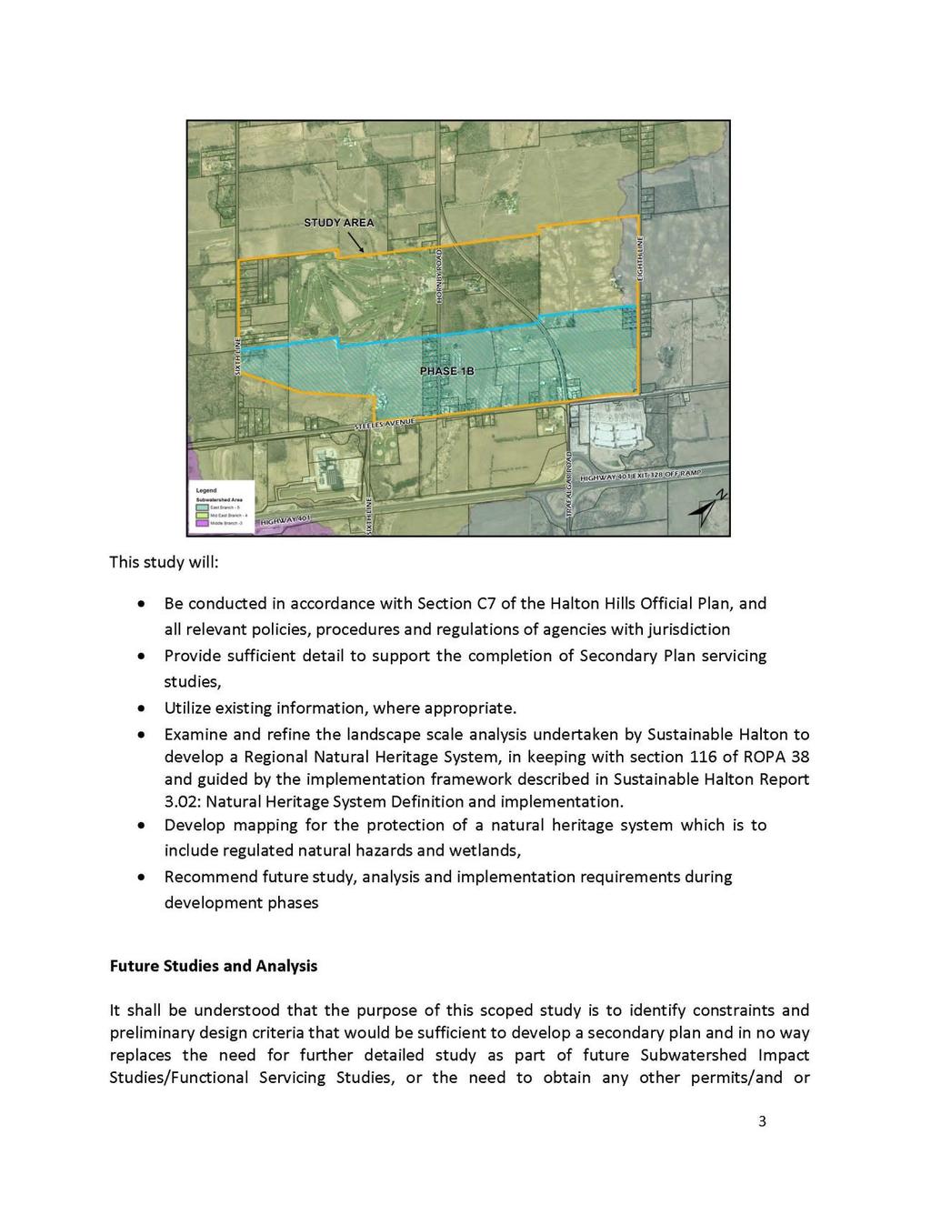
5 Secondary Plans, Urban Design and Greenlands The Official Plan also includes policies providing direction on the preparation of Secondary Plans (Section G3.1), incorporating good Urban Design (Section F2) into new development areas, and the preservation and enhancement of the Greenlands System (Section B1). The proposed Terms of Reference for the Premier Gateway Phase 1B Integrated Planning Project (Secondary Plan study) are consistent with the policy direction in the Official Plan. COMMENTS: Secondary Planning Exercise for Re-phased Employment Lands A detailed Secondary Plan Study is required to develop appropriate land use designations and policies for the Phase 1B Employment Area and identify up to 75 ha of additional land to be designated for employment and added to the Premier Gateway Employment Area to replace the shortfall of designated employment lands to the current 2021 planning horizon in the Town. Time Frame and Budget The project is expected to take months to complete following the awarding of the project to the successful consultant team. An upset limit of $650, is approved and allocated for the project in the Town s Capital Budget. Study Area The study area for the project will include the Phase 1B Employment Area and the contiguous area as identified below: Page 5
6 As outlined above, the project (Secondary Planning exercise) will also evaluate locations to accommodate up to 75 ha of additional employment land to replace land affected by corridor protection for the 2021 planning horizon. This supply, or a portion thereof, will be accommodated on lands contiguous the Phase 1B Employment Area. The specific location of the additional 75 ha of employment land, or a portion thereof, will be determined early in the study process. Detailed Work Plan The chosen Project Consultant will be required to prepare a detailed work plan for the project. The Terms of Reference for the project will serve as a framework to guide the preparation of the more detailed work plan. Public Consultation/Community Engagement Public consultation will be an important component of the project and opportunities for public consultation and community engagement have been incorporated throughout the various phases of the project. Public notification and community engagement will include: newspaper advertisements, newsletters, a project website, notification, public open houses/workshops, and a project Steering Committee that includes land owners and members of the public. Additional social media public engagement methods will be considered for use and employed when/where appropriate. A chart summarizing the proposed public engagement and deliverables proposed for the project is included in the proposed Terms of Reference for the project which are attached as Schedule 2 (see page of this Report). Final Product The final deliverables for the project will include: A Secondary Plan in accordance with the requirements of the Halton Hills Official Plan. The Secondary Plan will also include up to 75 ha, of additional designated employment lands to replace the land lost to corridor protection for the current 2021 planning horizon. An Implementing Town Official Plan amendment. A Zoning By-law amendment which zones the lands in accordance with the Secondary Plan. A Scoped Subwatershed Study for the Secondary Plan Area. Urban Design Guidelines for the Secondary Plan Area. An Implementing Region of Halton Official Plan Amendment and Town Official Plan Amendment to add the 75 ha, or a portion thereof, of the additional lands designated for employment to the Urban Area. Page 6
7 Secondary Planning/Scoped Subwatershed Study Integration A major component of the project is to undertake a Scoped Subwatershed Study for the study area with an overall goal to provide recommendations and a strategic framework for the protection, conservation and sustainable management of natural resources within and adjacent to the study area. The objectives of the Scoped Subwatershed Study will include ensuring the protection of natural heritage features and hydrological functions, and will involve detailed study to determine the limits of development, confirm the extent of the Regional Natural Heritage System, and make preliminary stormwater management recommendations. The project will integrate the Secondary Planning and Scoped Subwatershed Planning processes in order to ensure that the Scoped Subwatershed Study provides technical support to the Secondary Plan land use planning process. It is intended that the Scoped Subwatershed Study will be approved in conjunction with the approval of the Secondary Plan. Detailed Terms of Reference for the Scoped Subwatershed Study are included as part of the Terms of Reference for the integrated planning project (attached as Schedule 2). Terms of Reference for the Integrated Planning Project The proposed Terms of Reference for the Premier Gateway Phase 1B Employment Area Integrated Planning Project have been attached as Schedule 2 to this report. The Terms of Reference have been developed in accordance with the Town of Halton Hills Official Plan and addresses important planning considerations such as: Public Participation and Community Engagement Subwatershed Planning Natural Heritage System Protection Sustainability & Urban Design Servicing and Stormwater Management Agricultural Impacts Fiscal Impacts Land Use Compatibility Traffic and Transportation Planning The Integrated Planning Project has been organized into 5 phases as outlined below. It should be noted that the scheduling and timing of the various tasks will be finalized in the Detailed Work Program to be finalized by the Project Consultant. Phase 1: Project Initiation The first phase of the project will include the development of a Project Charter, a Detailed Workplan, and initiating a project kickoff which will include public notification of the commencement of the project. Page 7
8 Deliverables: Project Charter Detailed Work Program Project Website Newspaper Notice Phase 2A: Existing Conditions This Phase entails a review of relevant background material to provide a sound basis for decision-making and identifying the location of an additional 75 ha, or a portion thereof, of additional employment land contiguous to the Phase 1B Employment Area to replace the land lost to corridor protection for the current 2021 planning horizon. Deliverables: Background Paper Presentations to the Technical Advisory and Steering Committees Public Open House Public Consultation Paper Presentation to Council Initiation of Regional and Local Official Plan Amendment Processes Phase 2B: Subwatershed and Natural Heritage System Planning This phase involves the completion of a Scoped Subwatershed Study that allows for sustainable development and maximizes benefits to the natural and human environments on a watershed basis. The objectives of the Study will include ensuring the protection of natural heritage features and hydrological functions, and will involve detailed work to establish the limits of development, confirm the extent of the Regional Natural Heritage System, and provide preliminary stormwater management recomendations. The recommendations of the study will be used to develop appropriate land use policies within the Secondary Plan. This study will be conducted in accordance with the Halton Hills Official Plan, and must provide sufficient detail to support the completion of Secondary Plan servicing studies. It is intended that the Scoped Subwatershed Study be completed in conjunction with the approval of the Secondary Plan. It should be noted that the Terms of Reference for the Study have been purposely scoped shifting the implementation and monitoring details to the later more detailed Subwatershed Impact Study phase. According to the Halton Hills Official Plan, Subwatershed Impact Studies are to be completed at the development application stage when more site specific details are available as part of a development proposal. It should be noted that the Scoped Subwatershed Study will also identify the specific work that will need to be included and completed as part of the more detailed Subwatershed Impact Study phase at the time of development. Page 8
9 The Subwatershed Study will be the subject of a Detailed Work Plan to be developed based upon a Terms of Reference. This Detailed Work Plan will be developed by the chosen Project Consultant, in consultation with the Subwatershed Technical Advisory Committee (TAC). The TAC will be comprised of staff from the Town of Halton Hills, Region of Halton, and Conservation Halton. Deliverable: Scoped Subwatershed Study Phase 3: Detailed Planning Study This phase of the project involves the completion of a series of studies which will support the development of Secondary Plan policies and land use designations. The deliverables for this phase include the following studies: Transportation/Traffic Study Heritage Impact Assessment Functional Servicing Plan Urban Design Study Agricultural Impact Assessment Fiscal Impact Analysis Supportive Commercial Needs Assessment Land Use Compatibility Analysis Phase 4A: Recommended Land Use Option Building on the Background Paper and findings and recommendations of the various studies completed under Phase 3 of the project, a Recommended Land Use Option Report shall be prepared presenting and discussing the merits of a recommended land uses option. Initial recommendations from the Scoped Subwatershed Study including environmental constraint/limits of development mapping will also be considered and incorporated into the recommended land use option. The Consultant Team, with the support of appropriate Town Staff will present the recommended land use option to the public for comment at a second open house/workshop. Various design/technical scenarios such as potential road alignments will also be presented to the public for comment. All comments received are to be summarized and analyzed through the preparation of a Public Consultation Paper. Deliverables: Recommended Land Use Option Report Presentations to the Technical Advisory and Steering Committees Public Open House & Workshop Public Consultation Paper Page 9
10 Phase 4B: Preferred Land Use Plan Building on the work undertaken in Phase 4A of the project, the purpose of Phase 4B is to finalize a land use plan based on public input received and to present the plan to the Technical Advisory and Steering Committees. Subject to any refinements following consultation with the Committees, a preferred land use plan (as part of a Preferred land Use Plan Report) will be forwarded to Council for approval. Recommendations of the Scoped Subwatershed Study will also be incorporated into the preferred land use plan. Deliverables: Preferred Land Use Plan Report Presentations to the Technical and Steering Committees Presentation to Council Phase 5A: Draft Secondary Plan, Official Plan & Zoning By-law Amendments Phase 5A involves the preparation of a draft Secondary Plan and draft Official Plan and Zoning By-law amendments for the area based on the preferred land use plan. The draft documents will be presented to the Technical Advisory and Steering Committees for input. Any revisions that are necessary based on the input of the Committees will be made to the documents before they are presented to Council. Council will be asked to authorize the release of the documents for public review and comment at a public open house/workshop. Deliverables: Draft Secondary Plan, Draft Official Plan and Zoning By-law Amendments Draft Urban Design Guidelines Presentations to the Technical and Steering Committees Presentation to Council Public Open House/Workshop Public Consultation Paper Phase 5B: Final Secondary Plan, Official Plan & Zoning By-law Amendments In this final Phase of the project, the draft Secondary Plan, and draft Official Plan and Zoning By-law amendments will be revised as appropriate based on the public input received on the draft documents. The revised Secondary Plan and implementing amendments will be presented to the public for comment at a statutory public meeting under the Planning Act. Following the public meeting, the Project Consultant with the support of appropriate Town Staff will summarize and address public comments on the draft documents in a final recommendation report to Council regarding the adoption/approval of the Secondary Plan and related amendments. Deliverables: Statutory Public Meeting Presentation Final Secondary Plan & Amendments Council Presentation Page 10
11 Town Responsibility The Policy Division of the Town of Halton Hills Planning, Development and Sustainability Department will be responsible for leading and managing the completion of the project. Under the direction of the Manager of Planning Policy, the Sr. Planner Policy will coordinate and supervise the completion of the project. The Infrastructure Services Department will serve as the lead for the Scoped Subwatershed Study component of the project. Project Technical Advisory and Steering Committees The Terms of Reference for the project propose the establishment of Technical Advisory and Steering Committees to assist in the completion of the project. The Technical Advisory Committee (TAC) as proposed is to include Town, Region, Halton Hills Hydro, Ministry of Transportation and Conservation Authority Staff. The purpose of the TAC is to: Provide comments during the study process Assist with issue identification and resolution Members are to liaise with their respective organizations to ensure study awareness and to provide one-window coordination on behalf of their organization. Provide data input Meet on a regular basis to monitor the progress of the study The Project Steering Committee as proposed is to include: the Mayor, Regional Ward and Local Ward Councillors, representatives from the Town Sustainability Advisory Committee, Heritage Halton Hills, a Region of Halton representative Planning Staff, local Hornby area residents, and a Hornby area landowner(s) Development Interest. The purpose of the Steering Committee is to: Meet on a regular basis to monitor the progress of the study Provide comments during the study process Assist with issue identification and resolution Members are to liaise with their respective organizations or community of interest, both to ensure broad community awareness of the project, and to obtain broader community input. A recommendation of this report is that Council approve the establishment of the proposed Steering Committee. Page 11
12 Next Steps Following the approval of the recommendations of this Report and the attached Terms of Reference by Council, Town Staff will prepare and issue a Request for Proposals and commence the selection process to retain a qualified consulting team to undertake the project. Town Staff will provide a follow up report to Council summarizing the results of the selection process and seeking approval to hire the successful consultant candidate. Town Staff will also proceed with setting up the Steering Committee for the project and advertising for volunteers from the public/land owners to apply to sit on the committee. RELATIONSHIP TO STRATEGIC PLAN: Town of Halton Hills Strategic Plan The Town s Strategic Plan sets out goals and strategic objectives to lead the Town s into the future. Relevant goals and objectives relating to the Integrated Planning Project include: GOAL C. Foster a Prosperous Economy To maintain and enhance the economic vitality of the Town through the provision of a wide range of opportunities for economic development. Strategic Objectives C.1 To ensure an adequate supply of employment lands to provide flexibility and options for the business community and provide a range of job opportunities. Strategic Actions: C.1 (a) Undertake a Secondary Plan process for the Future Employment Area identified in OPA No. 10, and implement into Town Official Plan. C.1 (c) Preserve 2031 employment lands through HPBATS Corridor Protection process, by re-location if necessary, to ensure 340 ha secured through ROPA 38. Strategic Action Plan A Strategic Action Plan was developed by the Town of Halton Hills Council identifying Council s top ten priorities for the term. Strategic Action #3 identified that a Secondary Plan should be prepared for the 401 Corridor Future Employment Area. Page 12
13 FINANCIAL IMPACT: $650, is approved and allocated for the project in the Town s Capital Budget. COMMUNICATIONS IMPACT: Public consultation will be an important component of the project and opportunities for public consultation and community engagement have been incorporated throughout the various phases of the project. SUSTAINABILITY IMPLICATIONS: The Town is committed to implementing our Community Sustainability Strategy, Imagine Halton Hills. Doing so will lead to a higher quality of life. The relationship between this report and the Strategy is summarized below: Do the report s recommendations advance the Strategy s implementation? Yes No N/A Which pillar(s) of sustainability does this report support? Cultural Vibrancy Economic Prosperity N/A Environmental Health Social Well-being The Town s Integrated Community Sustainability Plan sets out a vision for Halton Hills to This report and the proposed Terms of Reference for the Phase 1B Employment Lands Integrated Planning Project are consistent with the Economic Prosperity, Environmental Health, and Cultural Vibrancy pillars and specific related goals of the Strategy. Relevant goals of the Strategy include: o Goal: Maximize the industrial benefits from existing and future designated employment lands (such as the 401/407 Gateway) o Goal: Achieve a stronger municipal tax assessment base through a substantial improvement in the ratio of non-residential to residential assessment. o Goal: Ensure that future urban areas are developed as a complete community, with compact pedestrian friendly neighbourhoods, a mix of housing types, appropriate employment opportunities, community facilities and open spaces. Overall, the alignment of this report with the Community Sustainability Strategy is: Excellent Very Good Good Fair N/A Page 13
14 CONSULTATION: Planning Staff consulted with Staff from the Town s Infrastructure Services Department, the Region of Halton and Conservation Halton to prepare the Terms of Reference for the Integrated Planning Project. CONCLUSION: This report has presented and summarized the proposed Terms of Reference for the Premier Gateway Phase 1B Employment Area Integrated Planning Project for Council. It is recommended that the attached Terms of Reference and recommendations of this Report be approved by Council and that the Manager of Purchasing be authorized to issue a Request for Proposals to retain a qualified Project Consultant to undertake the project. Town Staff will report back to Council on the results of the Project Consultant selection process. Respectfully submitted, Curtis Marshall, MCIP, RPP Sr. Planner Policy Steve Burke, MCIP, RPP Manager of Planning Policy John W. Linhardt, MCIP, RPP Director of Planning, Development & Sustainability David Smith Chief Administrative Officer Page 14

15 Schedule 1 to PDS Proposed Schedule A8 to OPA 10 Showing Employment Lands Re-phasing Page 15
16 Schedule 2 to PDS Proposed Terms of Reference Premier Gateway Phase 1B Employment Area Integrated Planning Project Terms of Reference 1.0 Introduction These Terms of Reference set out direction for the undertaking of the Premier Gateway Phase 1B Employment Area Integrated Planning Project (also referred to as a Secondary Plan), describing the project objectives, scope, and deliverables. The Terms of Reference also identify key stakeholders and participants, roles and responsibilities, required resources, deliverables, and a general work program for the project. 2.0 Background Sustainable Halton (ROPA 38) Implementation With the completion of the Sustainable Halton Process (the Region of Halton s growth management exercise) and the approval of Regional Official Plan Amendment 38 (ROPA 38) an additional 340 gross hectares (840 acres) of employment lands were designated for development in the Town of Halton Hills (on the north side of Steeles Avenue adjacent to the Premier Gateway Employment Area) to accommodate employment land needs for the 2021 to 2031 planning horizon. Through ROPA 38, this land was added to the Urban Area in the Regional Plan and identified to be serviced with municipal water and sewer. The Town s implementing Official Plan Amendment for Sustainable Halton and ROPA 38, Official Plan Amendment 10 (pending Regional approval), proposes to add the additional 340 gross hectares of land to the Town s Urban Area and designate the land for employment uses as Employment Area. OPA 10 sets out a framework to guide Secondary Planning exercises for the lands that will determine specific land use designations and policies. GTA West/HPBATS Corridor Protection In June 2014, the Region of Halton adopted ROPA 43 to implement a corridor protection area and policies to protect for the Halton Peel Boundary Area Transportation Study/Greater Toronto Area West Corridor Study Area from development through the Town of Halton Hills and Milton to allow for the completion of the GTA West Corridor Environmental Assessment (EA) study being undertaken by the Ministry of Transportation. The amendment also re-phased certain employment lands in the Town of Halton Hills that were affected by corridor protection. Page 16
17 Following the adoption of ROPA 43, Council for the Town of Halton Hills approved Official Plan Amendment 21 (OPA 21) on July 7, 2014 (Report PDS ) to implement corridor protection for the future GTA West Highway and Halton Peel Boundary Area Transportation Study (HPBATS) transportation improvements at the local level within the Town. The Corridor Protection Area Overlay freezes new development on all lands east of the Toronto Premium Outlets within the Town s Premier Gateway (401/407 Corridor) Employment Area. These lands will now be unavailable for development until the GTA West EA process is completed and it is determined what lands are/are not required for the transportation corridor. It is also anticipated that a significant amount of this area will be permanently precluded from development in order to accommodate a large highway interchange. The Ministry of Transportation (MTO) has advised that a preferred route will be recommended and taken to the public for their input by the end of Once the corridor is finalized, the MTO has indicated that areas not needed for the corridor can be removed from corridor protection. Premier Gateway Employment Lands Re-phasing As a result of the introduction of corridor protection (through ROPA 43 and OPA 21), and the re-phasing of employment lands by the Region of Halton (through ROPA 43) the Town is taking steps to re-phase the employment lands in the Premier Gateway Employment Area. This re-phasing will be accomplished through proposed modifications to OPA 10 as set out in Report PDS and endorsed by Council on July 7, The proposed modifications are as follows: Re-phasing the designated employment lands within the Future Employment Area which are outside of the GTA West Route Planning Study Area (north side of Steeles Ave., west of the Eighth Line), from the 2021 to 2031 planning horizon to the current 2021 planning horizon to replace the lands frozen to development by the Corridor Protection Area Overlay. These lands are identified as Phase 1B Employment Area on the revised Schedule A8 Premier Gateway Employment Area of OPA 10. Re-phasing lands within the Premier Gateway Employment Area located within the Corridor Protection Area Overlay (east of the Toronto Premium Outlets) from the 2021 planning horizon to the 2031 planning horizon to allow for the determination of the location of the GTA West Transportation route. These lands are identified as Phase 2B Employment Area on the revised Schedule A8 Premier Gateway Employment Area of OPA 10. The re-phasing of employment lands described above does not entirely replace the employment lands made unavailable for development by the Corridor Protection Area Overlay. There is an approximately 75 ha (185 acres) shortfall of designated employment land prior to 2021 as a result of the development freeze. Page 17

18 It should be noted that the revised OPA 10 is currently being reviewed by the Region of Halton, and a decision by the Region is expected in early Below is a copy of Schedule A8 of OPA 10 which shows the re-phased employment lands. Economic Development Strategic Action Plan One of the goals of the Town s Economic Development Strategic Action Plan is to Establish Halton Hills as a competitive location for new business investment. A recommended action of the Plan is to Review development phasing to ensure that additional serviced employment lands are available in the marketplace in a timely fashion. Strategic Action Plan A Strategic Action Plan was developed by the Town of Halton Hills Council identifying Council s top ten priorities for the term. Strategic Action #3 identified that a Secondary Plan should be prepared for the 401 Corridor Future Employment Area. Page 18
19 Town of Halton Hills Strategic Plan 2031 The Town s Strategic Plan sets out goals and strategic objectives to lead the Town s into the future. Relevant goals and objectives relating to the Secondary Plan include: GOAL C. Foster a Prosperous Economy To maintain and enhance the economic vitality of the Town through the provision of a wide range of opportunities for economic development. Strategic Objectives C.1 To ensure an adequate supply of employment lands to provide flexibility and options for the business community and provide a range of job opportunities. Strategic Actions: C.1 (a) Undertake a Secondary Plan process for the Future Employment Area identified in OPA No. 10, and implement into Town Official Plan. C.1 (c) Preserve 2031 employment lands through HPBATS Corridor Protection process, by re-location if necessary, to ensure 340 ha secured through ROPA 38. Integrated Community Sustainability Strategy The Town s Integrated Community Sustainability Plan sets out a vision for Halton Hills to Economic Prosperity is identified as one of the pillars of the Strategy. An identified goal of the Strategy is to Maximize the industrial benefits from existing and future designated employment lands (such as the 401/407 Gateway). Town of Halton Hills Official Plan The Town s Official Plan is the overall guiding land use planning document for Halton Hills. One of the objectives of the Official Plan is to ensure that there are sufficient lands available for the creation of diverse employment opportunities at strategic locations. The Plan identifies the Premier Gateway Employment Area (formerly known as the 401/407 Employment Corridor Area) as the area in the Town to accommodate large-scale employment growth. Through proposed modifications to OPA 10, the Premier Gateway Employment Area will be divided into separate areas based on the phasing of development. The new Phase 1B Employment Area will be the focus of the Premier Gateway Phase 1B Employment Area Integrated Planning Project. Page 19
20 Relevant polices (proposed) related to the Phase 1B Employment Area are listed below: D3.5.2 Location The Phase 1B Employment Area designation applies to the lands north of Steeles Avenue between the Greenbelt Plan Area and Eighth Line, which are subject to comprehensive planning, pursuant to Section D of this Plan. Development within the Premier Gateway Employment Area Phase 1 to the 2021 planning horizon shall occur in two sub-phases as illustrated on Schedule A8 to this Plan, as market demands dictate and the Town and Region of Halton are satisfied that a sustainable financial strategy is in place for each phase. It is the intent of this Plan that all development proceeds in a rational and orderly manner. Section D Phase 1B Employment Area D Objectives The objectives of the Phase 1B Employment Area designation are: a) to accommodate employment growth to the 2021 planning horizon; b) to provide for the continued development of the Premier Gateway Employment Area in order to enhance its development as a major employment area; and, c) to ensure that the urban design of the new development in the area enhances the area s location as a gateway into the Town of Halton Hills, and is sensitive to the character of the area. D Location The Phase 1B Employment Area designation applies to an expansion to the Premier Gateway Employment Area north of Steeles Avenue as shown on Schedule A8 of this Plan. D Comprehensive Planning Prior to the approval of any development within this designation, the following must be completed: a) a Secondary Plan, according to the policies of Section G3.1 of this Plan, including a Subwatershed Study appropriately scoped to the Phase 1B Employment Area, to the satisfaction of Council; b) appropriate financial plans and agreements, including any necessary front ending agreements, to the satisfaction of the Region and the Town; and, Page 20
21 c) appropriate development charge by-laws, to the satisfaction of Council. The Terms of Reference for the Secondary Plan exercise shall include an evaluation of alternative locations to accommodate a maximum 75 ha supply of employment land to the 2021 planning horizon, which are required to replace employment lands within Premier Gateway Employment Area Phase 2, subject to corridor protection. This supply or a portion of it, may be accommodated on lands contiguous to the Phase 1B Employment Area, by amendment to the Region Official Plan and this Plan, provided the total employment land supply to 2031, which underpins the employment distribution in Tables 1 and 2A of the Regional Official Plan, is not exceeded. D Regional Natural Heritage System Notwithstanding the policies pertaining to the Greenlands System contained in Section B1 of this Plan, the relevant Regional Natural Heritage System policies of the Regional Official Plan shall be applicable to the Greenlands designation within the Phase 1B Employment Area of this Plan. D Existing Rural Residential Concentrations Existing concentrations of rural residential development, which are unlikely to be redeveloped in the short term for employment uses, are identified on Schedule A8 to this Plan. Notwithstanding that these concentrations are anticipated to be designated for employment use through the subsequent Secondary Plan process, the following policies shall apply: a) subject to the Secondary Plan process, these concentrations may be zoned to permit the existing residential use and uses related to the residential use; b) through the Secondary Plan process, the Town may rezone the lands to permit the use of the existing residential dwellings for office or other uses that are compatible with both the adjacent residential uses, and uses permitted by the underlying employment designation; c) policies shall be incorporated into the Secondary Plan, which ensure the provision of landscape or other buffers between existing rural residential concentrations and future employment uses; d) through the Secondary Plan process, the development of a road network for the Phase 1B Employment Area, shall take into consideration the appropriateness of network solutions to address the existence of this residential concentration, including alternatives such as bypasses and cul-de-sacs. Secondary Plans, Urban Design and Greenlands The Official Plan also includes policies providing direction on the preparation of Secondary Plans (Section G3.1), incorporating good Urban Design (Section F2) into new development areas, and the preservation and enhancement of the Greenlands Page 21
22 System (Section B1). The proposed Terms of Reference for the Premier Gateway Phase 1B Integrated Planning Project (Secondary Plan study) are consistent with the policy direction in the Official Plan. 2.0 Project Scope, Budget and Time-Frames Secondary Planning Exercise for Re-phased Employment Lands A detailed Secondary Plan Study is required to develop appropriate land use designations and policies for the Phase 1B Employment Area and identify up to 75 ha of additional land to be designated for employment and added to the Premier Gateway Employment Area to replace the shortfall of designated employment lands to the current 2021 planning horizon in the Town. Study Area The study area for the Secondary Plan will include the Phase 1B Employment Area and the contiguous area as identified below: Page 22
23 As outlined in the Town s Official Plan through proposed OPA 10, the Secondary Plan exercise will also evaluate locations to accommodate up to 75 ha of additional employment land to replace land affected by corridor protection for the 2021 planning horizon. This supply (or a portion thereof) will be accommodated on lands contiguous the Phase 1B Employment Area. The specific location of the additional 75 ha, or a portion thereof, of employment land will be determined early in the study process. Time Frame and Budget The project is expected to take months to complete following the awarding of the project to the successful consultant team. An upset limit of $650, is approved and allocated for the project in the Town s Capital Budget. Detailed Work Plan This Terms of Reference will serve as a framework to guide the preparation of a more detailed work plan by the chosen Project Consultant. This detailed Work Plan will be reviewed and approved by the Project Team, in consultation with the Technical Advisory Committee, which includes staff from the Town of Halton Hills, Region of Halton, and Conservation Halton. A chart summarizing the deliverables for the project is attached as Schedule A. Public Consultation/Community Engagement Public consultation is an important component of the project and public comments will be considered throughout the planning process. Opportunities for public consultation and community engagement have been incorporated throughout the various steps in the process to provide an opportunity for public participation and input. Public notification and community engagement will include: newspaper advertisements, newsletters, a project website, notification, public open houses/workshops, and a project Steering Committee that includes land owners and members of the public. Additional social media public engagement methods such as blogs, twitter, mind mixer etc. will be considered for use and employed when/where appropriate. Proposed public engagement has been included in the chart summarizing deliverables for the project attached as Schedule A. Final Product The final deliverables for the project will include: A Secondary Plan in accordance with the requirements of the Halton Hills Official Plan. The Secondary Plan will also include up to 75 ha, or a portion thereof, of additional designated employment lands to replace the land lost to corridor protection for the current 2021 planning horizon. An Implementing Town Official Plan amendment. Page 23
24 A Zoning By-law amendment which zones the lands in accordance with the Secondary Plan. A Scoped Subwatershed Study for the Secondary Plan Area. Urban Design Guidelines for the Secondary Plan Area. An Implementing Region of Halton Official Plan Amendment and Town Official Plan Amendment to add the 75 ha, or a portion thereof, of the additional lands designated for employment to the Urban Area. All electronic documents and reports prepared for and submitted to the Town shall be compliant with the Accessibility for Ontarians with Disabilities Act, 2005 as may be amended. 3.0 Secondary Planning/Scoped Subwatershed Study Integration A major component of the project is to undertake a Scoped Subwatershed Study for the study area with an overall goal to provide recommendations and a strategic framework for the protection, conservation and sustainable management of natural resources within and adjacent to the study area. The objectives of the Scoped Subwatershed Study will include ensuring the protection of natural heritage features and hydrological functions, and will involve detailed study to determine the limits of development, confirm the extent of the Regional Natural Heritage System, and make preliminary stormwater management recommendations. The project will integrate the Secondary Planning and Scoped Subwatershed planning processes in order to ensure that the Scoped Subwatershed Study provides technical support to the Secondary Plan land use planning process. It is intended that the Scoped Subwatershed Study will be approved in conjunction with the approval of the Secondary Plan. The Terms of Reference for the Scoped Subwatershed Study are attached as Schedule B. 4.0 Project Design Phase 1: Project Initiation Project Charter This initial task will include the completion and agreement on the contents of a Project Charter between the Town, Region and Conservation Halton setting out agreed upon roles and responsibilities of each stakeholder. Deliverables: Project Charter Page 24
25 Detailed Work Program This task will involve start-up meetings with the Project Consultant Team to review and finalize a detailed work program for the project, based upon the proposed work program contained in the chosen consultants proposal. The detailed work program including review timeframes will also be reviewed with the Technical Advisory Committee for the project. Deliverables: Detailed Work Program Project Kick-off Notice will be given to the public of the commencement of the project and will include creating a project website and placing a newspaper notice in the Independent & Free Press. Deliverables: Project Website Newspaper Notice Phase 2A: Existing Conditions This Phase entails a review of relevant background material to provide a sound basis for decision-making and identifying the location of an additional 75 ha, or a portion thereof, of additional employment land contiguous to the Phase 1B Employment Area to replace the land lost to corridor protection for the current 2021 planning horizon. Pertinent background information includes, but is not limited to: Places to Grow Greater Golden Horseshoe Growth Plan Provincial Policy Statement (2014) Greenbelt Plan (2005) Planning Act, R.S.O, c.p.13 Region of Halton Official Plan, as amended including ROPA 38 etc. Region of Halton Guidelines: EIA, Agricultural Impact Assessment etc. Region of Halton: Transportation Master Plan to 2031 the Road to Change Region of Halton: Sustainable Halton Water and Wastewater Master Plan Region of Halton Best Planning Estimates Halton Hills Official Plan (September 2006), as amended including OPA 10, OPA 21 etc. Town of Halton Hills Comprehensive Zoning By-law (By-law ) as amended Town of Halton Hills Zoning By-law: (401 Corridor) Page 25
26 Town of Halton Hills Strategic Plan & Economic Development Strategic Action Plan Town of Halton Hills Integrated Community Sustainability Strategy Town of Halton Hills Mayor s Community Energy Plan Town of Halton Hills Green Development Standards Town of Halton Hills Transportation Master Plan Update Town of Halton Hills Cycling Master Plan Town of Halton Hills Long Range Financial Plan Town of Halton Hills Heritage Register Halton Hills Retail Market Demand Study update (2010) 401 Integrated Planning Project Scoped Subwatershed Plan (Dillon 2000) Subwatershed Impact Studies 401 Corridor: Higgins, TCE, Premier Outlets EA/EIR Studies - Steeles Ave. (Region of Halton), TCE Generating Station, Halton Hills Hydro Sub Station etc. Sixteen Mile Creek Watershed Plan Conservation Halton Policies and Guidelines for the Administration of Ontario Regulation 162/06 and Land Use Planning, August 11, 2011 Building on the aforementioned material, the successful Project Consultant will prepare a Background Paper which provides pertinent information on various Provincial, Regional, local and conservation authority plans and policies and their implications on the study area and which reviews, analyzes and recommends the most appropriate location of an additional 75 ha, or a portion thereof, of employment lands contiguous with the Phase 1B Employment Area within the study area to replace the land lost to corridor protection for the current 2021 planning horizon. The Project Consultant, with the support of appropriate Town staff will present the Background Paper to the Technical Advisory and Steering Committees. Any revisions that are necessary to the Paper flowing from the Committee consultation will then be undertaken prior to proceeding to a Public Open House. The Public Open House presents the first opportunity to actively engage residents and stakeholders in the Secondary Plan development. All public comments are to be summarized and analyzed through the preparation of a Public Consultation Paper. Input from the public will be considered prior to the Background Paper and the recommended location of the additional 75 ha of employment lands (or a portion thereof) being finalized. The preferred location for the employment lands will then be presented to Council for approval. It is anticipated that following Council s endorsement of the recommended location of the additional 75 ha of employment lands (or a portion thereof) that Regional and Local Official Plan Amendments will be initiated to designate the additional lands as Urban Area in the Regional Plan and as Premier Gateway Employment Area Phase 1B in the Page 26
27 Town s Official Plan. A statutory public meeting under the Planning Act will be required as part of the amendment process. Deliverables: Background Paper Presentations to the Technical Advisory and Steering Committees Public Open House Public Consultation Paper Presentation to Council Initiation of Regional and Local Official Plan Amendment Processes Phase 2B: Subwatershed and Natural Heritage System Planning This phase involves the completion of a Scoped Subwatershed Study that allows for sustainable development, which maximizes benefits to the natural and human environments on a watershed basis. The objectives of the Study will include ensuring the protection of natural heritage features and hydrological functions, and will involve detailed work to establish the limits of development, confirm the extent of the Regional Natural Heritage System, and provide preliminary stormwater management recomendations. The recommendations of the study will be used to develop appropriate land use policies within the Secondary Plan. The study area is located within the Sixteen Mile Creek Watershed, which is administered by Conservation Halton. The lands are within the Eastern Branches of Sixteen Mile Creek. There are a number of tributaries that drain through the lands, resulting in the need to consider upstream drainage areas and land use, the provision of protecting these tributaries though the study area, as well as mitigation of downstream impacts. There are also headwater tributaries within the study area that will need to be evaluated and classified with regard to the appropriate management approach, in accordance with current principles and guidelines. The background reports for the Sixteen Mile Creek Watershed provide watershed level guidance that is to be used in the development of a subwatershed management strategy. This study will be conducted in accordance with Section C7 of the Halton Hills Official Plan, and must provide sufficient detail to support the completion of Secondary Plan servicing studies. It is intended that the Scoped Subwatershed Study be completed in conjunction with the approval of the Secondary Plan. The Scoped Subwatershed Study (SWS) process consists of preparation of a Background Report and two SWS phases: SWS Phase 1 Characterization SWS Phase 2 Analyses and Impact Assessment It should be noted that the Terms of Reference for the Study have been purposely scoped shifting the implementation and monitoring details to the later more detailed Subwatershed Impact Study phase. According to the Halton Hills Official Plan, Subwatershed Impact Studies are to be completed at the development application stage when more site specific details are available as part of a development proposal. It should also be noted that the Scoped Subwatershed Study will also identify the Page 27
28 specific work that will need to be included and completed as part of the more detailed Subwatershed Impact Study phase at the time of development. The Subwatershed Study will be the subject of a Detailed Work Plan to be developed based upon a Terms of Reference forming an attachment to this Terms of Reference (See Schedule B). This Detailed Work Plan will be developed by the chosen Project Consultant, in consultation with the Subwatershed Technical Advisory Committee (TAC). The TAC will be comprised of staff from the Town of Halton Hills, Region of Halton, and Conservation Halton. Deliverable(s), which shall be reviewed and approved by Council: Scoped Subwatershed Study Phase 3: Detailed Planning Study This phase of the Study involves the completion of a series of studies which will support the development of Secondary Plan policies and land use designations. The deliverables for this phase include each of the following completed studies: Transportation/Traffic Study This study will review future planned road improvements and will consider and make recommendations of any additional improvements necessary to facilitate development of the area. Factors to consider include: the need for and conceptual design of a local internal road system, incorporation of active transportation (sidewalks, bike lanes, trails), streetscaping and incorporating Complete Street design principles, traffic impacts of development, entrance and intersection locations, intersection and turn lane improvements, road network changes such as introducing cul de sacs, and or bypasses to address rural residential concentrations on Hornby Road and on the Eighth Line. The Region of Halton will also be consulted through the undertaking of this report as the road authority for Steeles Ave. and Trafalgar Road. Heritage Impact Assessment Building on the heritage inventory work completed by Heritage Halton Hills and the Town s Heritage Register this study will review and inventory heritage resources in the area, and will develop a strategy to conserve those resources where appropriate in accordance with Section F5 of the Official Plan. Functional Servicing Plan This study will review the servicing needs and develop a servicing plan for the area. Consultation will take place with the Region of Halton regarding water and wastewater servicing, and consideration will be given to the Sustainable Halton and Wastewater Master Servicing Plan, and Section F8.2 of the Town of Halton Hills Official Plan. Recommendations regarding stormwater management infrastructure are to correspond with the findings and recommendations of the Scoped Subwatershed Study. Low impact development techniques should be incorporated where appropriate. Page 28
29 Urban Design Study This study will build on the existing 401 Corridor Urban Design Guidelines that were approved in 2002 and will develop new urban Design guidelines for the study area. The new Guidelines will apply to all new development in the study area and will be developed in accordance with Section F2 and F3 of the Official Plan. Sustainable development practices and concepts such as LEED and low impact development (LID) techniques will be promoted and incorporated into the Guidelines where appropriate. Agricultural Impact Assessment This study will examine the impact of future development of the area on the agricultural operations and resources in the surrounding area, (including Minimum Distance Setback requirements) and the development of measures to mitigate those impacts. Reference shall be made to the Region of Halton s Agricultural Impact Assessment Guidelines and Livestock Facility Guidelines. Supportive Commercial Needs Assessment This study will determine the need for commercial floor space in the new development area to support the employment uses and how much land should be designated/zoned for these commercial uses. Fiscal Impact Analysis Building upon the Town s Long Range Financial Plan, the Fiscal Impact Analysis will determine the overall financial contribution and cost implications of the development of the lands for Employment uses, as the basis for the calculation of development charges. Land Use Compatibility Analysis This study will review the potential impacts of employment uses on existing residential clusters in the study area in accordance with Section C14 of the Official Plan, the Region of Halton Official Plan, and Ministry of Environment Guidelines. Consideration will be given to noise, dust, light, odour, air quality and vibration impacts of new employment uses on the existing residential uses. The study will make recommendations to minimize and mitigate conflict by introducing greater setbacks, berming, landscaping etc. Reference shall be made to the Region of Halton s Land Use Compatibility Guidelines and Air Quality Impact Assessment Guidelines. Page 29
30 Phase 4A: Recommended Land Use Option Building on the Background Paper and findings and recommendations of the various studies completed under Phase 3 of the project, a Recommended Land Use Option Report shall be prepared presenting and discussing the merits of a recommended land use option. Initial recommendations from the Scoped Subwatershed Study including environmental constraint/limits of development mapping will also be considered and incorporated into the recommended land use option. The recommended land use option will be presented to the Technical Advisory Committee and the Steering Committee for review and comments. Appropriate revisions to the Recommended Land Use Option Report resulting from input of the Committees will be made prior to the document being presented to the public. The Project Consultant, with the support of appropriate Town Staff will present the recommended land use option to the public for comment at a second open house/workshop. Various design/technical scenarios such as potential road alignments will also be presented to the public for comment. All comments received are to be summarized and analyzed through the preparation of a Public Consultation Paper. Deliverables: Recommended Land Use Option Report Presentations to the Technical Advisory and Steering Committees Public Open House & Workshop Public Consultation Paper Phase 4B: Preferred Land Use Plan Building on the work undertaken in Phase 4A of the project, the purpose of Phase 4B is to finalize a land use plan based on public input received and to present the plan to the Technical Advisory and Steering Committees. Subject to any refinements following consultation with the Committees, a preferred land use plan (as part of a Preferred land Use Plan Report) will be forwarded to Council for approval. Recommendations of the Scoped Subwatershed Study will also be incorporated into the preferred land use plan. Deliverables: Preferred Land Use Plan Report Presentations to the Technical and Steering Committees Presentation to Council Phase 5A: Draft Secondary Plan, Official Plan & Zoning By-law Amendments Phase 5A involves the preparation of a draft Secondary Plan and draft Official Plan and Zoning By-law amendments for the area based on the preferred land use plan. The draft documents will be presented to the Technical Advisory and Steering Committees for input. Any revisions that are necessary based on the input of the Committees will be made to the documents before they are presented to Council. Council will be asked to authorize the release of the documents for public review and comment. Page 30
31 The Project Consultant, with the support of appropriate Town Staff, will present the draft documents to the public for review and comment at the third public open house and workshop. All comments received are to be summarized and analyzed through the preparation of a Public Consultation Paper. Deliverables: Draft Secondary Plan, Draft Official Plan and Zoning By-law Amendments Draft Urban Design Guidelines Presentations to the Technical and Steering Committees Presentation to Council Public Open House/Workshop Public Consultation Paper Phase 5B: Final Secondary Plan, Official Plan & Zoning By-law Amendments In this final Phase of the project, the draft Secondary Plan, and draft Official Plan and Zoning By-law amendments will be revised as appropriate based on the public input received on the draft documents. The revised Secondary Plan and implementing amendments will be presented to the public for comment at a statutory public meeting under the Planning Act. Following the public meeting, the Project Consultant with the support of appropriate Town Staff will summarize and address public comments on the draft documents in a final recommendation report to Council regarding the adoption/approval of the Secondary Plan and related amendments. Deliverables: Statutory Public Meeting Presentation Final Secondary Plan & Amendments Council Presentation 3.0 Town Responsibility The Policy Division of the Town of Halton Hills Planning, Development and Sustainability Department will be responsible for leading and managing the completion of the Secondary Plan project. Under the direction of the Manager of Planning Policy, the Sr. Planner Policy will coordinate and supervise the completion of the project. Responsibilities of the Sr. Planner-Policy will include: Coordinate a Technical Advisory Committee comprised of representatives from Town Departments, the Region of Halton, Conservation Halton and other public agencies as determined appropriate Coordinate a Steering Committee comprised of selected members of Town Council, Town Advisory Committees, staff, local residents, landowners and the Region of Halton Ensure financial resources are well managed Ensure compliance with the Terms of Reference Ensure participation of all stakeholders Chair Technical Advisory and Steering Committee meetings Coordinate communications Page 31
32 Coordinate public consultation program Update web information Prepare status reports to Council Coordinate with other studies as appropriate Project Steering Committee The members of the Project Steering Committee shall include: Mayor (ex-officio) Regional Councillor Ward 2 Local Councillors Ward 2 Town Sustainability Advisory Committee representative (1 alternate) Heritage Halton Hills representative (1 alternate) Region of Halton representative Planning Staff Hornby Area Residents (3) Hornby Area Landowner(s) Development Interest The role of the Steering Committee is as follows: Meet on a regular basis to monitor the progress of the study Provide comments during the study process Assist with issue identification and resolution Members to liaise with their respective organizations or community of interest, both to ensure broad community awareness of the project, and to obtain broader community input. Project Technical Advisory Committee: The members of the Project Technical Advisory Committee shall include: Town of Halton Hills Staff representing the following Departments and Sections: o Planning Development and Sustainability Manager of Planning Policy, Sr. Planner Policy (Planner Development Review may attend as required) o Infrastructure Services Transportation & Development Engineering o Finance o Recreation and Parks o Economic Development o Staff from other departments as needed Region of Halton representative Planner (Planner to coordinate with Transportation, Water/Waste Water Staff to attend as required) Conservation Halton representative Planner Halton Hills Hydro representative Ministry of Transportation representative Page 32
33 The role of the Technical Advisory Committee is as follows: Provide comments during the study process Assist with issue identification and resolution Members to liaise with their respective organizations to ensure study awareness and to provide one-window coordination on behalf of their organization. Provide data input Meet on a regular basis to monitor the progress of the study Project Support -Student Position The Planning, Development and Sustainability Department may employ a university student (enrolled in a Planning degree program or a related discipline) on a part time basis to assist with/support the project. $5000 may be funded from the project budget for the student. Page 33
34 Schedule A to Terms of Reference Key Deliverables by Phase and Proposed Engagement PHASE 1 Deliverables Project Charter Detailed Work Program Proposed Engagement Webpage Launch* Newspaper Notice PHASE 2 A Deliverables Background Paper Expanded Phase 1 B Secondary Plan Area Public Consultation Paper Region of Halton Official Plan Amendment Town Official Plan Amendment Proposed Engagement Social Media/Mind Mixer * Webpage update* Presentations to TAC and Steering Committees Newsletter Public Open House Council Presentation PHASE 2 B Deliverables Scoped Subwatershed Study Proposed Engagement See Subwatershed Study Terms of Reference PHASE 3 Deliverables Transportation/Traffic Study Heritage Impact Assessment Functional Servicing Plan Urban Design Study Agricultural Impact Assessment Supportive Commercial Needs Assessment Fiscal Impact Analysis Land Use Compatibility Analysis Proposed Engagement PHASE 4A Deliverables Recommended Land Use Option Report Public Consultation Paper Proposed Engagement Webpage Update* Presentations to TAC and Steering Committees Social Media/Mind Mixer* Newsletter Page 34
35 Public Open House & Workshop PHASE 4B Deliverables Preferred Land Use Plan Report Proposed Engagement Webpage Update* Presentations to TAC and Steering Committees Social Media/Mind Mixer* Presentation to Council PHASE 5A Deliverables Draft Secondary Plan Draft Official Plan and Zoning By-law Amendments Draft Urban Design Guidelines Public Consultation Paper Proposed Engagement Webpage Update* Social Media/Mind Mixer* Presentations to TAC and Steering Committees Presentation to Council Newsletter Public Open House & Workshop PHASE 5B Deliverables Final Secondary Plan & Amendments Proposed Engagement Webpage Update* Social Media/Mind Mixer* Statutory Public Meeting Presentation Council Presentation * Note these are considered ongoing community engagement initiatives that will be undertaken throughout the entire project. Page 35
36 Schedule B to terms of Reference Page 36
37 Page 37
38 Page 38
39 Page 39
40 Page 40
41 Page 41
42 Page 42
43 Page 43
44 Page 44
45 Page 45
46 Page 46
47 Page 47
48 Page 48
49 Page 49
50 Page 50
51 Page 51
52 Page 52
53 Page 53
54 Page 54
55 Page 55
56 Page 56
57 Page 57
58 Page 58
59 Page 59
60 Page 60
61 Page 61
62 Page 62
63 Page 63
64 Page 64
65 Page 65
66 Page 66
67 Page 67
68 Page 68