Unmanned Little Bird H-6U
|
|
|
- Bruno Hutchinson
- 5 years ago
- Views:
Transcription


1 Unmanned Little Bird H-6U Development of Navigation and Automated Flight Control System Solutions for Maritime VTOL UAS Operations

2 Mark Hardesty with Co-Authors Travis Berka - Boeing Sandy Kennedy NovAtel Sheena Dixon NovAtel Jason Graham Boeing Don Caldwell - Boeing MPG ppt

3 Maritime Operations Testing Develop a primary navigation solution (IRAD)

4 Test Program Objectives Integration and demonstration of a precision navigation system to enable ship board terminal operations (takeoff/landing) Evaluate cockpit enhancements for complex airspace and challenging visibility conditions enhanced situational awareness and ability to safely cope with inadvertent IFR flight Training for maritime flight operations both for flight crew members and for the engineering test team on the yacht Shake out the functionality of Boeing s proprietary COMC2 ground control station software and examine the potential for integration of the Landing Period Designator system
 developers")
5 Key Participants and Elements NovAtel - provider of a precision navigation solution Garmin provider of the cockpit instrument panel equipment as well as a prototype RADAR altimeter with the Automated Flight Control System The Squadron maritime flight operations training for Boeing test pilots, flight test team, and fire/crash rescue crew personnel Boeing Ground Control Station (COMC2) developers examining integration with the developer of the Landing Period Designator Shadow Marine w/ Killian Yacht & Ship Brokers providing a suitable helipad equipped vessel

6 Unmanned Little Bird (ULB) Rapid prototyping test platform for developing and deploying game changing technologies and capabilities for VTOL UAS Militarized AV with combat proven capability and reliability Demonstrated unmanned sensor and strike integration Optionally piloted capability speeds development, reduces risk and cost, and your prototype sensors always come home intact MPG ppt


7 ULB Demonstrated Capabilities Flight Tested Capabilities since 2004 Ship-based navigation Weaponization EO / IR / LD integration Comm Relay SIGINT Cargo Re-supply STANAG 4586 GCS Tactical flight profiles Unmanned flight CASEVAC Autonomous Sensor Cueing Manned-unmanned teaming MPG ppt MPG ppt MPG ppt Demonstrated Capabilities MPG ppt One-person GCS Weapons Cued EO / IR / LD Unmanned Resupply Ship-based navigation MUM Teaming Precision Landing CASEVAC SIGINT Comm Relay COMC2 Frigate Integration


8 Garmin Instrument Panel / RADAR Altimeter Improve situational awareness Flight safety for degraded visual environment New RADAR altimeter integration with AFCS to improve terminal operations control
9 Risk Management - Maritime Training The Squadron - providing Pilot training Yacht crew training crash response and wave off criteria for landing safety officer Visual cue environment for rotor clearance

10 Risk Management Test Conduct Stand alone fire system WOD & deck motion limit monitoring Boeing fire/crash rescue team Test team situational awareness in the command center


11 Origin & Evolution - the Navigation Concept MD900 & YO-3A precision formation flight for noise research LASER range finder and alignment stripes st generation of a precision dual-platform relative navigation solution NovAtel OEM-4 SPAN 2 nd generation NovAtelSPAN-SE

12 Testing RADAR Navigation July 2011 NovAtel OEM-4 SPAN vetted as a TSPI system to evaluate the accuracy of a RADAR navigation solution
13 NovAtel OEM-4 SPAN Performance - Trailer X = (m), standard deviation = (m) Y = (m), standard deviation = (m) Z = (m), standard deviation = (m)
14 NovAtel OEM-4 SPAN Performance H-6U Mean Std Dev Easting 0.06 cm 1.08 cm Northing 0.01 cm 1.54 cm Altitude 0.25 cm 2.15 cm
15 NovAtel OEM-4 SPAN Conclusions OEM-4 SPAN data generated in a fixed reference station Real Time Kinematic (RTK) environment demonstrates high confidence in the 3- dimensional solution for both: Low dynamics of the trailer environment (similar to a ship) High dynamics of the H-6U Both vehicles equipped with the Honeywell HG tactical grade Inertial Measurement Unit (IMU) OEM-4 lacks computing resources and is no longer supported, so time to move to a more contemporary solution
16 NovAtel SPAN-SE Contemporary Solution for Relative Navigation Adequate processing capability in the SPAN-SE Multiple communication ports USB Ethernet RS-232 / RS-422 (4) Solution developed uses a single communications port to link the ship and H-6U SPAN-SE systems together and generate a relative INS message, including: X, Y, Z relative position (meters) X, Y, Z relative velocities (meters/second Roll, pitch, yaw relative attitudes (degrees) Integrity data BOEING PROPRIETARY

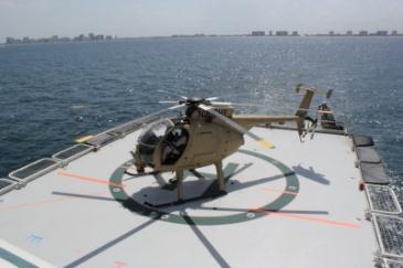
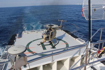
17 H-6U Initial Landings
")
18 ULB Rapid Prototyping Architecture Display Interface Unit (DIU) inputs to change Automated Flight Control System (AFCS) response
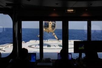
19 Fully Integrated Terminal Operations

20 NovAtel SPAN-SE Results Relative RTK


21 Summary ULB over 1000 flight hours as UAV without accident Low risk integration and development using OPV approach Demonstrated a navigation system integration that allows large ship multiple landing spot capability Optionally piloted approach generates huge savings in development, debugging, demonstration, and fielding costs while greatly increasing operational tempo MPG ppt


22