Implementing Mobile GIS in the Rail Industry
|
|
|
- Katherine Fox
- 5 years ago
- Views:
Transcription

1 1 Implementing Mobile GIS in the Rail Industry
2 Presenters Douglas Braeckel, GISP Senior Software Engineer, CSX Technology Erik Henderson, GISP GIS Business Consultant, CSX Technology 2
3 Presentation Outline North American Railroads About CSX Business Uses for GPS Enabled Mobile GIS Office Car Tracking WIU Inventory PTC Power PS&E SPCC Tank Inspections PTC Change Management Lessons Learned Questions? 3


4 The Scope of N.A. Railroad Infrastructure Railroad classes are defined by operating revenue. Class I: Revenue > $347 Billion 7 US, 2 Canadian, 2 Mexican Class II, Class III 33 Regional, 320 Local Line Haul, 200 Switching & Terminal RRs Railroads account for more than 40% of all US freight transportation. Freight railroads receive no public funding for infrastructure or rolling stock. 40% of revenue goes to capital expenditures for track and equipment. Coal, intermodal, chemical, and grain traffic are major commodities. 4


5 N.A. Railroads by the Numbers Railroads own and maintain 173,000 mi of track in 140,000 mi of right of way. Amtrak owns and maintains 750 mi & operates on 22,000 mi owned by others. 1.5M freight cars in service < 50% owned by the major RRs. 24,000 locomotives in service 12M containers & trailers in Intermodal business. 226,000 employed in rail industry. Average length of haul is 900 miles. CSX pays property tax in 22 states, 2 provinces, 968 counties on 360,000 acres of real estate. 5

6 About CSX CSX Corporation is one of the nation s leading transportation suppliers. CSX provides rail, intermodal, and rail to truck transload services. The CSX network spans 21,000 miles with service to 23 eastern states and the District of Colombia. 6

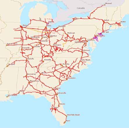
7 CSX System Map 7
8 CSX Technology / GIS Mission: Provide GIS services for CSX Corporation Application Development Data Development Routing Geocoding Geofence Integration Mapping and Analysis 8
9 Business Uses for GPS Enabled Mobile GIS Basic Accuracy Basic Tracking and Routing Office Car Tracking Medium Accuracy Feature Collection WIU Inventory PTC Power SPCC Tank Inspections High Accuracy Feature Survey Collection PTC Change Management 9

10 Office Car Tracking Displays current location of train on Closed Circuit TVs. Constantly pings underlying cache data for attribute information. Shows current city, state, county, subdivision, speed, heading and more. Displayed data is SDC data format. 10


11 WIU Inventory Collection of all Wayside Interface Units. 12 Trimble Juno SCs. Dynamically on the fly built forms based on featureclass data model. Connect to CSX network via built in cellular modems. Users can fully sync data, by subdivision, in the field. 11


12 PTC Power Facilitates the planning for the location of new power features in dark territories. Supports the digitization of new power poles and houses. Data is extracted based on contractor s needs. Synced to the network via USB cable. 12


13 PS&E SPCC Tank Inspections Monthly inspections of storage tanks and other features. Several dozen devices in use at once. Data selectively synced via USB based on facility name. 13

14 PTC Change Management Survey new or changed features in a timely manner. A seamless part of a bigger work flow. Flexible enough to handle any scenario in the field. 14
15 Lessons Learned Don t try to build an ArcMap for the field. Caching half of the country on an SD card can be challenging. Integrating mobile into the enterprise is more difficult than it sounds. Must be able to work around the inevitable hardware / software issues. Cache checksums can become out of sync. Versioning or landing tables are a must. 15
16 Questions? 16