WSDOT NWR SPaT Challenge. Ali G. Eghtedari, Ph.D., PE, PTOE WSDOT-NW Region Regional Traffic Operations Engineer RTOC Presentation, July 2018
|
|
|
- Susanna Douglas
- 5 years ago
- Views:
Transcription
1 WSDOT NWR SPaT Challenge Ali G. Eghtedari, Ph.D., PE, PTOE WSDOT-NW Region Regional Traffic Operations Engineer RTOC Presentation, July 2018
2 Presentation Layout AASHTO Challenge Intro to SPaT & DSRC Hardware Soft Side Schemes WSDOT Projects Locations Systems Engineering Needs assessment Estimates Future Trends
 to achieve deployment of Dedicated Short Range Communications (DSRC) infrastructure with SPaT (and MAP)")
3 SPaT Challenge What is the AASHTO Challenge? To challenge state and local transportation infrastructure owners and operators (IOOs) to achieve deployment of Dedicated Short Range Communications (DSRC) infrastructure with SPaT (and MAP) broadcasts in at least one corridor or network (approximately 20 signalized intersections) in each state by January 2020 Purpose of the Challenge is: To provide IOOs with an entry into DSRC-based V2I deployment and procurement, licensing, installation, and operation experience: Show a commitment to OEMs and applications developers What are the benefits? Be more prepared for DSRCequipped vehicles and on-board applications and useful as test bed for them; We have to start small... and scale up! Supports deployment of V2I/PID applications that build on SPaT at intersections: Improved Safety and Mobility for traveling public o Improved Safety for Pedestrians o Access for Active Transportation and Vulnerable Users o Smart Transit/ Freight Signal Priority o Red Light Violation Warning o Eco-Driver o Etc. Source 3
, and coexists as a primary use along with other Federal users authorized by the National Telecommunications and Information Administration (NTIA), as well as with a number of commercial")
4 DSRC Service The DSRC operates in the MHz band (the 5.9 GHz band), and coexists as a primary use along with other Federal users authorized by the National Telecommunications and Information Administration (NTIA), as well as with a number of commercial satellite operators. Responsibilities include Reviewing FCC service rules, regulations, and technical requirements; field deployment and planning; Licensing administration and ongoing management activities. Coordination with Existing Co Primary Users (e.g. Fixed Satellite) Radio Frequency Analysis and Survey of "Unlicensed" Systems (e.g. Wi Fi) Security Credentialing and Service/Application Commissioning 4


5 SAE J Messages A Signal Phase and Timing (SPaT) message defines the current and future steps of the intersection traffic signal phases; Current state of all lanes at intersection are provided, as well as any active preemption or priority. Various Schemes V2i HUB or ASC DSRC or Cloud Compliant messages for broadcast SPaT Signal Phase and Timing MAP Intersection Geometry BSM Basic Safety Message SRM Signal Request Message SSM Signal Status Message TIM Traveler Information Message RTCM - The Radio Technical Commission for Maritime Services, Position Correction Future J2735 messages Source 5


6 Road Side & On Board Units (RSU, OBU) Until OBUs are in place, how do we know? That MAP and SPaT is actually being broadcast? How far from the RSU can it be received? Can RSU receive Basic Safety Message (BSM)? What other applications could be deployed with OBU and RSU? E.g. EV Priority/Preemption, Transit Priority, Freight Priority, P.M. Observation, Source 6

7 MAP Message MAPs represent sets of related lanes; Each lane is a closed polygon Attributes define width, moves and prohibitions, etc. MAPs support a 1 cm resolution Lines represent 8 different lane types with a common structure. Includes: Motor Vehicles, Ped Lanes, Medians, Bicycle Lanes, Trains, etc. Each Lane Type has the attributes it needs to describe its use case. BSMs can easily be placed on a flattened MAP for application use. Source 7
 Reversible Lanes Time of Day Parking Lanes Left Turn, Right on Red and other Crossing")
8 Messages Summary A typical MAP message has One Intersection with Many Lanes (each with a LaneID, and GroupIDs, in its ConnectsTo) A MAP message is Static, And contains all relevant lane details The SPaT message is Dynamic, All time of day details (which lane description is to be used at a given time of day) Reversible Lanes Time of Day Parking Lanes Left Turn, Right on Red and other Crossing lanes that vary with time A typical SPaT message has One Intersection (may not be one signal controller) Active Movements, each with TimeMarks for GroupIDs Source 8
 apps & functions o Operational scenarios o References for requirement Verification and Validation o Demonstration, test, analysis, inspection Traceability to needs")
9 Systems Engineering Approach; System that meets user needs o Common understanding of intent o Stakeholders role Operational needs (Use Case Diagram) o User oriented operations Functional requirements o Concept(s) apps & functions o Operational scenarios o References for requirement Verification and Validation o Demonstration, test, analysis, inspection Traceability to needs Source 9
 Back End Cabling Mounting Software Requirements Messages Performance Security Software Development Kit (SDK) Needed for software development /")

10 Infrastructure Hardware Requirements RSU 4.1 Specification V2i HUB (optional) Back End Cabling Mounting Software Requirements Messages Performance Security Software Development Kit (SDK) Needed for software development / modification Implementation Procurement Variations Applications Beyond SPaT Outside Certification & Licensing OBUs (optional) Testing Cost Estimates Hardware RSU $1500 to $3200 Mounting Brackets, Cables, Power Supply OBU $200 to $600 $900 to $1500 Engineering Design / Testing $1000 to $8500 Installation / Integration $2000 to $11,000 Lane Closures / Night Work Create MAP Data $400 to $1500 Use of Tool Local Mapping Communication $4-$40K for the corridor. O&M $2-$3K a year per intersection. 10


11 WSDOT Accepts the SPaT Challenge NWR-10 Locations along SR 522 North of Lake Washington through the Cities of Lake Forest Park and Kenmore, ER-4 Locations along US 2 North and West of the City of Spokane, OR-6 Locations along SR 305 from the Bainbridge Island Ferry Terminal to the City of Poulsbo, SWR-4 Locations along SR 500, between I-5 and I-205, through the City of Vancouver. 83 rd Pl NE Lake Washington NE 153 rd St. 11

12 SR 522 Project 10 Intersections along Lake City Bothell Way NE (SR 522) Heavy commuter traffic With recreational active Burke Gilman Trail 12


 is")

13 Current Project Sponsors WSDOT Northwest Region Traffic Operations, WSDOT HQ Traffic Research, WSDOT Cooperative Connected Automated Mobility. Intelight ITS company Hardware sponsor and integrator. University of Washington Star Lab (UW) is partnering in developing an application for PID users Washington State University at Pullman (WSU) is partnering in research and testing of the system. 13
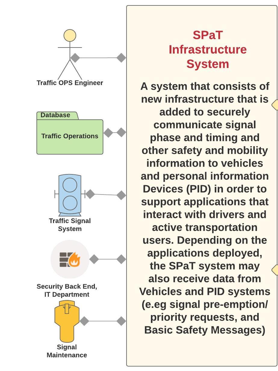
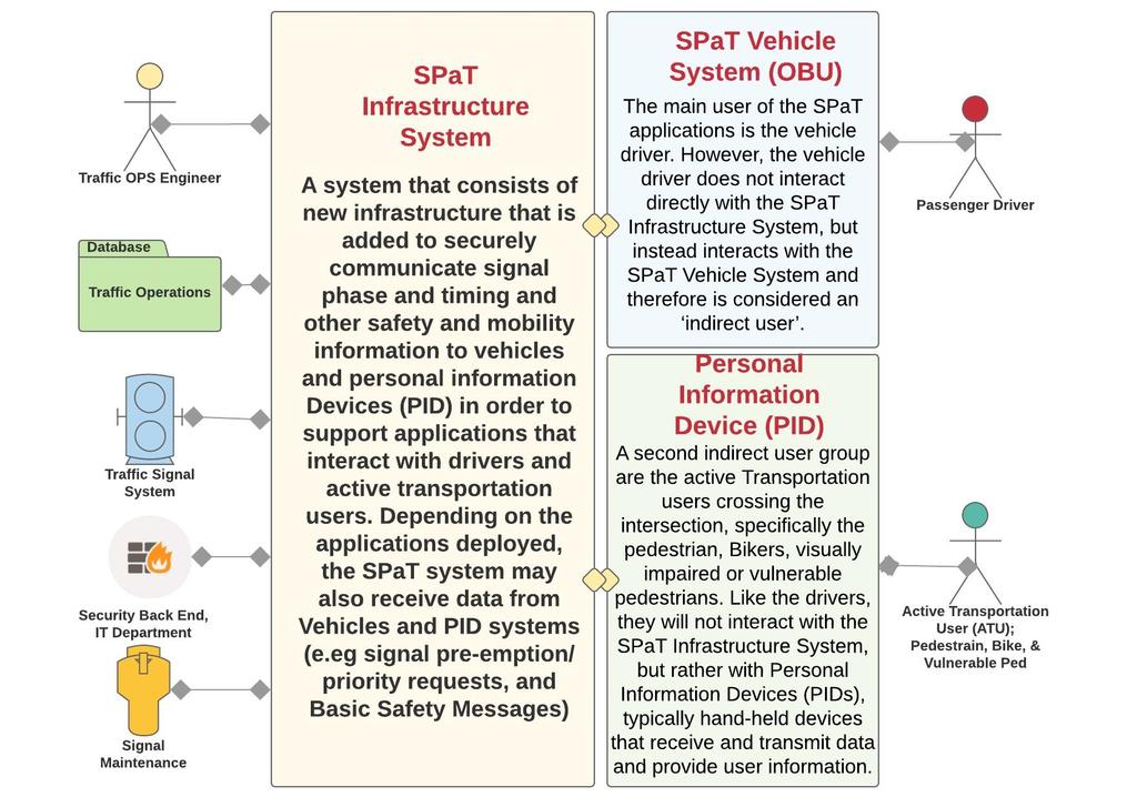
14 Stakeholders 14


15 Ideal Case Use Diagram 15
16 Active User Needs Vision Impaired User Difficulty placing a call for a walk indication Difficulty discerning the current state of the walk/don't walk indications Vision Impaired User Difficulty placing a call for a crossing indication and may be vulnerable to drivers who do not see them in Bike lane on the right. Bicycles Pedestrian During a permitted crossing time may still be vulnerable to drivers who do not see them in crosswalk 16
17 Personal Information Device Needs PID There is no mechanism for PIDs to send messages directly to Traffic Signal Systems to communicate cross requests. There is no mechanism for PIDs to receive data or information directly from Traffic Signal Systems. PID PGPS In order to accurately determine if pedestrians are outside the designated crosswalk, their position must be accurately determined. 17
18 Vehicle System Needs SPaT Veh. Providing Red Light Violation Warning (RLVW), Pedestrian in Crosswalk, Bike in Bike lane, and Eco Arrival / Departure (Eco A/D), applications requires information from the SPaT Infrastructure System. The driver of a commercial Freight, transit or emergency vehicle approaching a traffic signal does not know if the signal will be green when the vehicle reaches the intersection, and so does not know if they need to prepare to stop at the intersection. Comm. Driver Traffic Data Arterial Traffic Signal Performance Measures and arterial traveler information would benefit from increased information about vehicles. 18
19 Security Needs Back End Security Risk of unauthorized systems imitating vehicles and sending data to the roadside equipment. Risk of unauthorized systems imitating the infrastructure and sending inappropriate data to vehicles. Back End Security IT Dept The agency must protect the signal controller, network, and central system that interfaces with the SPaT Infrastructure System from unwanted access or malicious intents. 19
20 DSRC Licensing WSDOT has a statewide geographic area license from FCC (valid until 2025). We need location licenses per each radio installed. (pending) Installation by State source Testing and reporting by WSDOT staff 20


21 SR 522 Cost Estimates SR 522 project has a proposal of 70-80K for 10 intersections including: DSRC Antenna, MAP, OBU Module, SPaT License. NE153rd NE 165th NE 170th SR st Ave 68 th Ave Backhaul communication for the corridor exists. Ongoing operations and maintenance $2-$3K a year per intersection, 73 rd Ave 77 th Ave 80 th Ave 83 rd Pl 21


22 SPaT Challenge Resources One-stop shop for SPaT-related information Overview Current map with SPaT deployment details and contacts Resources: Corridor Selection Guide DSRC Licensing Guide Concept of Operations Model Functional Requirements Model Advancing Automated and Connected Vehicles: Policy and Planning Actions for State and Local Transportation Agencies [NCHRP Report 845] 22
23 Future Trends Market penetration forecasts: 32.4% no advance changes 40% advanced features (WTP $1100) 16.5% Partial Automation (WTP $1500) 11.1% Fully AV (WTP +$2000) Impacts of CV/AV on Traffic Signals (MMiTSC) Use of BSM, MAP, SPaT Performance Observation, including ATSPM Travel Time, Delay, Stop, AoG, Queue Length Safety: Number of Conflicts Movements: LT, Th, RT Mode: Veh., Transit, Freight, Ped. Bike Controls: Ph Call, Ph Extend, Dilemma Zone, Coordination Adaptive Traffic Control Priority control: EMS, Transit, Truck, Ped & Bike 23
 to upwards of 550 (e.g., Portland, Ore). They all need to have digitized MAP information for SPaT at some point Who will be in charge of this task, Who pays for it?")
24 Future Trends NTOC 2012 National Traffic Signal Report Card estimates approximately $83 Billion in public investment in more than 300,000 traffic signals Cities range from 45 intersections per square mile (like Salt Lake City) to upwards of 550 (e.g., Portland, Ore). They all need to have digitized MAP information for SPaT at some point Who will be in charge of this task, Who pays for it? Who maintains it? 24

25 Questions? Ali G. Eghtedari, Ph.D., PE, PTOE