SMART SCALE Training Session Fall Transportation Meetings
|
|
|
- Gilbert Cunningham
- 5 years ago
- Views:
Transcription

1 SMART SCALE Training Session 2017 Fall Transportation Meetings
2 Overview SMART SCALE Refresher Legislation Factors and Scoring SMART Portal Round 3 Proposed Changes Identifying Candidate Projects STARS Overview and Approach General Observations Factor specific advice Safety Congestion Accessibility Economic Development Environment Land Use Rethinking Solutions 2
3 Quick Refresher SMART SCALE Legislation
4 Virginia s Statewide Prioritization Process Legislation championed by Democratic Governor and the Republican Speaker of the House 2014 Virginia General Assembly of the Code of Virginia Requires Commonwealth Transportation Board (CTB) use objective and quantifiable process for the allocation of construction funds Board allocates construction funds for the Commonwealth Programming of funds for capacity enhancing projects Intent for the CTB to select the highest ranking projects however, they maintain the authority to propose adjustments to the rankings. Policy developed over a 16 month period and adopted by Commonwealth Transportation Board in June
5 Reformed Funding Formulas In 2015 legislature adopted Administration s recommended revisions to funding formulas Replaced the formula as well as the temporary CTB formula New formula distributes funds as follows: 45% for State of Good Repair with funds assigned to districts based on asset conditions 27.5% for District Grant Program distributed to districts based on old formula for in-district competition through SMART SCALE 27.5% for High Priority Projects Program for statewide distribution based on SMART SCALE All districts are guaranteed more funding through new formula than under old formula 5
6 Quick Refresher SMART SCALE Factors/Scoring 6

7 SMART Scale Factors 7
8 Factor Areas Goals that guided measure development Safety reduce the number and rate of fatalities and severe injuries Congestion reduce person hours of delay and increase person throughput Accessibility increase access to jobs and travel options Economic Development support economic development and improve goods movement Environmental Quality improve air quality and avoid impacts to the natural environment Land Use support transportation efficient land development patterns 8


9 How Scoring Works Everything is Relative

10 Everything is Relative Highest Value Dictates Scores Change here only affects one score Change here affects all scores The best project for that measure dictates the score for all other projects 10

11 Area Type Weighting Factor Congestion Mitigation Economic Accessibility Development Safety Environmental Land Use Quality Category A 45% 5% 15% 5% 10% 20% Category B 15% 20% 25% 20% 10% 10% Category C 15% 25% 25% 25% 10% 11 Category D 10% 35% 15% 30% 10%
12 Sample Project Scoring Congestion Project "A" - located in Typology A Accessibility Environ. Econ. Dev. Land Use Multimo Natural Econo Travel Trans. F &SI F &SI Access to Goods Access to dal Air & Cult. mic Tim Efficient Throughput Delay Crashe Crash Jobs (Dis. Moveme Jobs Choice Quality Resour Develo Reliabilit Land s Rate Pop.) nt s ces pment y Use Measure Score 62 Measure Weight 50% Weighted Measure Score Safety % 50% 50% % 20% % 50% 50% 60% 20% % 100% Factor Weighting (Typ. A) 45% 5% 15% 10% 5% 20% Weighted Factor Score Raw Factor Score Project Score Total Project Cost Score Divided by Total Cost SMART SCALE Cost Score / SMART SCALE Cost 35.9 $20,000, $10,000,

13 How does cost affect the SMART SCALE score? State law requires that benefits produced by a project be analyzed on a basis of relative costs Results are provided to CTB based on: Benefits relative to $ request Benefits relative to total costs Official SMART SCALE Score is Benefit Score Requested $ 13 13
14 Quick Refresher SMART Portal 14
15 SMART SCALE / SMART Portal SMART SCALE (formerly HB2) is an application based process in which projects are scored and prioritized for funding based on an objective process SMART Portal is an on-line web based tool established to collect project applications for Round 1 of SMART SCALE SMART Portal has been enhanced to collect project applications for Revenue Sharing, Transportation Alternatives Set-Aside (formerly TAP), and Highway Safety programs The application submission period varies by program Revenue Sharing August 1 November 1 Highway Safety Programs August 1 November 1 Transportation Alternatives September 1 November 1 State of Good Repair (Bridges and Paving) TBD SMART SCALE (Round 3 Proposed) March 1 August 1 15
16 Background / Refresher Information 16
17 Fund Eligibility All project applications must meet an identified need in the Commonwealth s long-range transportation plan VTrans
18 Applicant Eligibility *Locality submitted projects within MPO boundaries must include a resolution of support from the MPO 18
19 Project Eligibility and Screening Process Projects must be sufficiently developed Studies are not eligible Projects must be a capital improvement, transportation demand management or safety project Projects must meet a need identified in VTrans 2040, and projects need to be on at least one of the following: Corridors of Statewide Significance Regional Networks Improvements to promote Urban Development Areas (UDAs) Safety 19 19
20 State Roles and Responsibilities Local/Regional Liaisons Provide technical assistance to applicants: Coordinate candidate projects with District SMART SCALE Lead Help determine VTrans need eligibility: CoSS, UDA, Regional Network or safety need Work with district resource team to refine project description and scope, schedule, estimates, and supporting documentation conceptual sketch, previous studies, etc. Develop cost estimates by phase and identifies local/regional contribution of funding Guide applicants on information and data needed for SMART SCALE application FOCUS on Quality over Quantity 20 20
21 Applicant Roles and Responsibilities Scope/ Schedule/ Estimates Local/Regional applicants will be required to provide the following information when submitting a project under SMART SCALE Point of contact Who will administer project? Project priority (if submitting more than one) Detailed project description/scope Project sketch Project status, cost estimate and duration by phase Measure information related to Accessibility, Economic Development, Environment, and Land Use (area types A & B) Amount of SMART SCALE funding requested Description of any non-smart SCALE funding committed to project Applicable supporting documents (resolutions, plans, studies, etc.) 21
22 Applicant Roles and Responsibilities Scope/ Schedule/ Estimates Project applications must include the following information: Scope - The scope should define the limits of the project, its physical and operational characteristics, and physical and/or operational footprint. Cost Estimate - Cost estimate should be as realistic as possible considering known information and should account for possible risk and contingencies. Schedule Anticipated schedule should be realistic and reflect complexity of project and identify phase durations (PE, RW, CN) VDOT and DRPT will assist applicants in the development of project scopes, cost estimates, and schedules 22
23 Web Application 23
24 How to Log-In Using the URL (to be provided): From the Authentication page, select Forgot Password if you had an account in the system last year You should receive an to reset your password If you did not have an account, we will set you up as a new user and you should receive an that will include your password. Your will be your username. Use notification that includes link and temporary password My Account Review User Information Change Password 24
25 User / Organization Administration Enhanced/Modified Roles and Responsibilities District/Administrator POC manages permissions for District/Organization Manage users through Account administration Administrator role only (located as a dropdown from your name in the tool bar) Setting up New Users An address can only be associated with one organization so unless person has alternate address, they cannot be set up for more that one organization ex both the MPO and the PDC Archiving Users If users have left the organization, then their account should be archived 25
26 Administrator POC Managing Existing Users Users access can be limited by role and application programs Users can be assigned roles from multiple programs Each application program has the roles of Viewer, Editor, Submitter Viewer can View applications created by others for the assigned program Editor can View and Edit applications for the assigned program Submitter can View, Edit, and Submit applications for the assigned program Example: A user is assigned only Highway Safety Improvement Application Submitter, that user can only view, edit, and submit Highway Safety Improvement Applications. 26
27 Creating/Submitting Applications Applications can be copied from prior submission or from other application programs Applications can be edited, saved, submitted Supporting documents can be uploaded New/Revised Data Fields Each application program enhanced based on lessons learned and streamlining 27

28 SMART Portal Two new application programs Coming Soon: State of Good Repair for Bridges and Paving 28

29 New Features Comment and alerts improved tag and filter to each pearls to streamline review and collaboration 29
30 Prioritize Applications From Dashboard, applications can be prioritized note applications must first be submitted Once all application programs are available, Dashboard will display each grant program Once submitted, an application may be unsubmitted, edited, and resubmitted up to the deadline 30
31 Notes/Recommendation Recommend using Chrome, Firefox or Internet Explorer 11 If you use IE9, be sure to save you work every 5-10 minutes by clicking Save and Continue on bottom right portion of page Multiple editors the system will allow two users to be editing the same application at the same time last person to save wins if editing the same field Applicants are strongly encouraged to use the Pre-Application Coordination Form and work closely with VDOT/DRPT staff prior to entering projects into the Web Application Please do not respond to the that provides the login credentials. Instead, 31
32 Round 3 - Proposed Changes CTB to take action in October Seeking input to proposed changes 32

33 Biennial Schedule Prepping for Round 3 Start Now Begin application intake March 1st 2018 June 1st deadline for creation of an application August 1st submission deadline 5 month project evaluation and scoring window - 2 more months than previous rounds 5 month application intake window - 3 more months than previous rounds 33 33
34 Number of Applications 34 Round 1 Round 2 % Change Total # Submitted % Total # Scored % Average # Application % Max # of Applications %
35 Recommended Limits on Number of Applications June CTB Meeting Generated Significant Discussion Approach modified Established 2 tiers based on population 35 Tier Localities MPOs/PDCs/Transit Agencies Maximum Number of Applications 1 Less than 200K Less than 500K 4 2 Greater than 200K Greater than 500K 8
36 Recommended Limits on Number of Applications Increases total number of applications by 111 Tier No. of Local/Regional Entities Maximum Number of Applications 1 (4 apps max) (8 apps max) Grand Total
37 Impact of Recommendation on Applicants Applicants that would be limited based on population tiers 14 applicants impacted, two less than 3-tiered approach 37
38 Project Readiness Formalize and strengthen policy on required level of project planning New interchange on limited access facility IJR with preferred alternative Grade separation of at-grade intersection At-grade improvement options have been assessed New signal Signal warrants have been met and signal justified Major widening Corridor optimization and alternatives to new lanes have been evaluated Demonstrate that a project has public support, requiring resolution of support from governing body 38
39 Project Eligibility Clarify the ineligibility of maintenance and State of Good Repair (SGR) projects If project scope is mostly the repair or replacement of existing assets then it is not eligible for SMART SCALE Examples include: Signal system replacement (mast arms, signal heads) Bridge replacement with wider lane widths and/or ped accommodations 39
40 Funding and Related Elements Full Funding Policy Program not intended to replace committed local/regional funding sources, proffers, and/or other committed state/federal funding sources If $ request is to add components to existing fully funded project then requested components will be analyzed independently Relationship of Major Project Elements Add guidance that project elements must be associated (contiguous or same improvement type) 40
41 Measures Congestion Person throughput scale based on length Safety Remove DUI crashes and use blended rate for fatal and severe injury crashes Accessibility A.1 and A.2 - Access to Jobs Eliminate the 45 and 60 minute cap for auto and transit job access respectively Land Use More specific definitions of mixed-use development New methodology - Accessibility to key non-work destinations such as grocery, healthcare, education, etc. 41
42 Measures Economic Development - ED.1 - Site Development Remove 0.5 points for consistent with local and regional plans - project specifically referenced in local comp plan or regional economic development strategy = 0.5 points Project within economically distressed areas get up to 0.5 points Zoned properties must get primary/direct access from project Conceptual (0.5, 1) vs detailed site plans (2, 4 points) points based on whether submitted or approved Reduce buffer to max of 3 miles Considering establishment of maximum square footage based on project type and based on current level of development - cannot exceed x% of total current square footage in jurisdiction(s) Economic Development - ED.2 - Intermodal Access Scale freight tonnage-based measure by the length of the improvement 42
43 Identifying Candidate Projects 43
44 Readiness Challenge Before SMART SCALE, projects could receive $ allocations and project details could be developed during PE phase Under SMART SCALE, projects need to be adequately planned and developed Project details are needed to 1) understand the scope, 2) develop an accurate cost estimate and 3) calculate the expected benefits Change to project scope and/or estimate after it is funded could trigger re-evaluation and rescoring More complex projects require more thorough planning Often overlooked: 44

45 Developing candidate projects 45
46 STARS Program VDOT planning program created 10 years ago Identify corridors with safety and congestion issues Corridors, intersections, bottleneck locations, safety hot spots Develop comprehensive, innovative transportation solutions Advance projects to SYIP and/or Maintenance Track implementation 46

47 STARS Approach Links planning to operations/its, safety and design Accelerates process of planning to design Involves other disciplines in the planning process Improves thoroughness of scope and accuracy of cost estimates and schedules 47
48 STARS Approach 48


49 SMART SCALE STARS Approach Application 1 Application 2 49
 Planning Time Index (PTI) Buffer Time Index (BTI) Other Available for download and use at: https://app.box.")
50 STARS Data/Mapping Mapping visually represent safety and congestion data Potential for Safety Improvement (PSI) Intersections Segments Travel Time Index (TTI) Planning Time Index (PTI) Buffer Time Index (BTI) Other Available for download and use at: 50
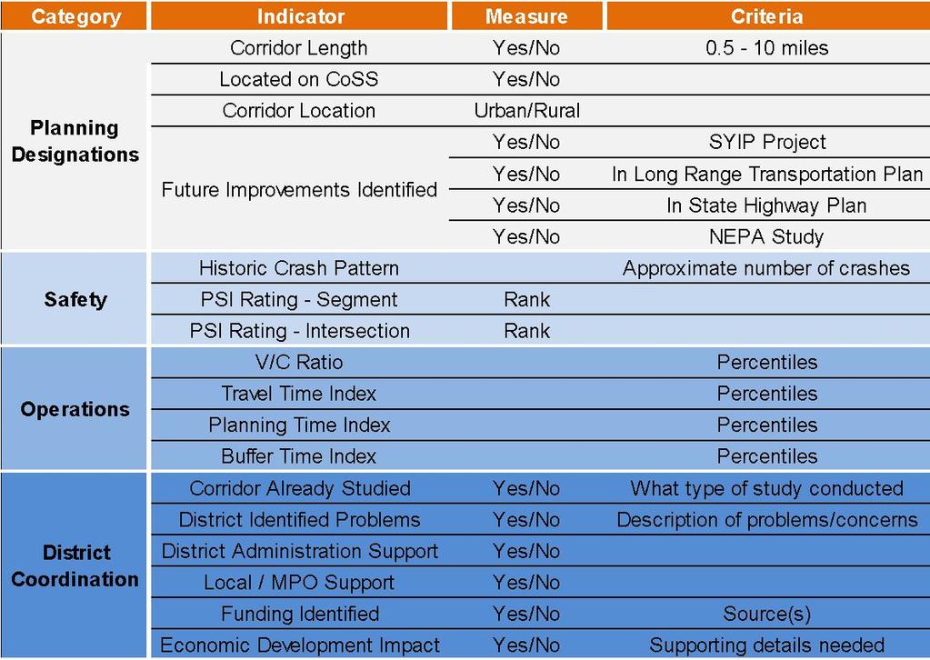
51 STARS Data/Mapping 51

52 STARS Data/Mapping Map package for your district can be downloaded at

53 Project Development Corridor 53
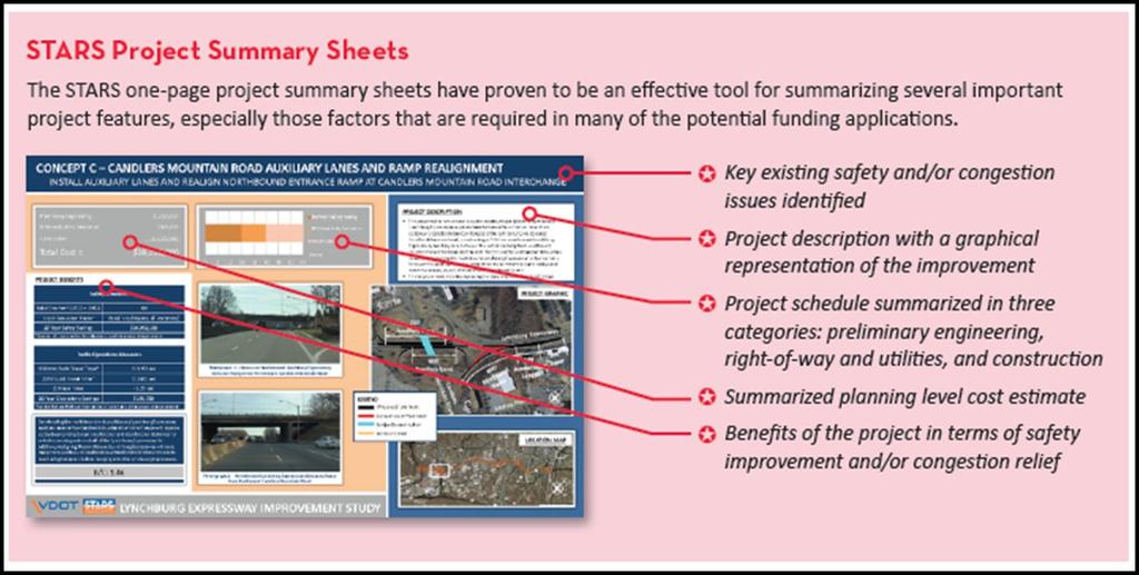
54 STARS Deliverables 54

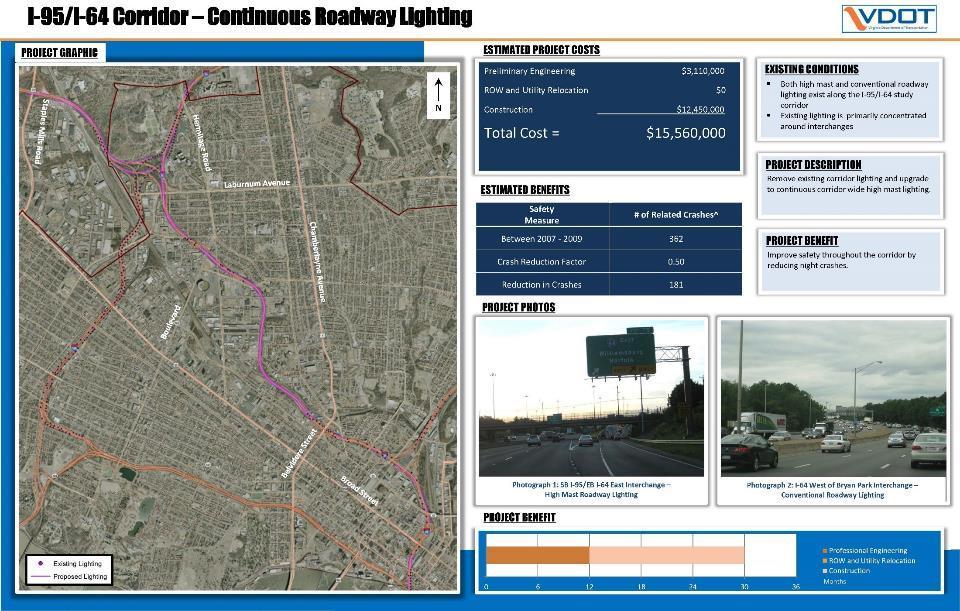
55 STARS Example 55

56 STARS Example 56
57 STARS Project Advancement Determine Priorities Local Regional District Select Projects to Advance Based on Priorities Prioritize on Annual Basis Identify Funding Sources Track Advancement SMART SCALE CLRP MPOs TIP/STIP SYIP Phase (PE, ROW, Construction) 57
58 Developing Candidate Projects - Maximizing scoring potential General Observations Factor specific advice Safety Congestion Accessibility Economic Development Environment Land Use Rethinking Solutions 58
59 How To Maximize Scores General Observations Area Type Weighting keep this in mind what is weighted high/versus low projects that provide benefits in factor areas that are weighted high will score better Project Cost focus scope on problem/needs Project that provides 100% of the benefit at 100% of the cost will not score as well as project that provide 75% of the benefit at 30% of the cost Thinking beyond Single Occupant Vehicles (SOVs) opportunities for bike/ped, transit, TDM Economic Development leaving blank = 0 points It is very difficult to consider data/information if it is not included in application submittal if available please be sure to upload traffic/studies/analysis
 with reduced conflicts and greater delay savings with free flow movements and reduced signal phases Opportunities for access management and")
60 How To Maximize Scores Project Scope Don t forget intersections Significant safety and delay benefits can be realized with innovative intersection treatments RCUT, jug handle, Quadrant Roadway, displaced-left, etc Higher Crash Modification Factor (CMF) with reduced conflicts and greater delay savings with free flow movements and reduced signal phases Opportunities for access management and signal elimination Opportunities to eliminate signal will eliminate delay associated with them Can cross-overs be eliminate, entrances consolidate? full movement to right-in right-out
61 Considerations for Projects with Transit and Rail Components Identify and plan for all project components needed for calculations of benefits Bus O&M facility expansion or roadway widening projects with bus shelters Include plans for new or additional transit services Express bus or rail services expansion projects that rely on park-and-ride facilities If required for the service, include plans for park-and-ride facility expansions Document all services and facilities, provide all necessary data Reach out to DRPT for questions related to transit and rail components 61
62 Measuring SAFETY 50% of score Expected reduction in Equivalent Property Damage Only (EPDO) crash frequency (100% of score for transit projects) 50% of score Expected reduction in Equivalent Property Damage Only (EPDO) crash rate Factor Category A Category B Category C Category D Congestion Economic Environmenta Accessibility Safety Mitigation Development l Quality 15% 5% 45% 5% 10% 25% 20% 15% 20% 10% 25% 25% 15% 25% 10% 15% 30% 10% 35% 10% Land Use 20% 10% 62
63 Safety - How Highway Projects Compile fatal/injury crash data for project limits (5 years) Segment project for safety analysis (segments and nodes) Convert crashes to EPDO Weights Propose using a blended Fatal (K) weight for Round 3 Severe Injury (A) - 30 Minor Injury (B) - 10 Non-visible injury (C) - 5 Based on project scope select Crash Modification Factor(s) Use CMF(s) to calculate reduction in crashes and rate 63 63

64 CMFs How a CMF works # of crashes before project * CMF = number of crashes expected to remain after project Lower number is better - CMF of 0.20 means 80% of crashes are expected to be eliminated 64

65 CMFs For list of planning level Crash Modification Factors used in SMART SCALE please visit the SMART SCALE Resources page - Link under safety


66 Safety How to Improve Score Poor Access Management Look for opportunities to reduce conflict points Good Access Management


67 Safety How to Improve Score 67

68 Rural Application - US 17 in Leland, NC 55% decrease in Fatal and Injury crashes RCUTs can be implemented without signals 68
69 Safety - How Transit*/Travel Demand Management/New Location Identify corridor(s) served - where project will reduce VMT Compile fatal/injury crash data for project limits (5 years) Convert crashes to EPDO Use ridership/volume (new riders) reduction to calculate reduction in VMT Use VMT reduction to calculate crash reduction *Transit - Fatal and Injury frequency weighted at 100% Key inputs Corridor(s) served - where transit project will reduce vehicle demand Daily ridership estimate 69
70 Safety Measures Proposed Changes for Next Round Many fatalities and severe injuries are the result of factors unrelated to roadway design Vehicle age and age of occupants plays a major role in determining whether a crash results in a fatality or severe injury Statistics from 2013 NHTSA Report 71% more likely to die if car is 18+ years old 50% more likely to die if car is years old 2012 AAA Traffic Safety Report Deaths per 100 million VMT decrease from age 16 until age 60 then it increases sharply (survivability) Current methodology weights fatalities 18x greater than severe injuries 70
71 Safety Measures Proposed Changes for Next Round Roadway improvements often cannot address crashes resulting from driving under the influence Have had a project recommended for funding due to single crash over 5-year period that involved alcohol Recommend removing crashes that are the result of driving under the influence from consideration in scoring Difference between fatality and severe injury often related to age of vehicle and age of occupant Many states used a blended value for fatalities and severe injuries Recommend the use of a blended weighting for SMART SCALE similar to other states in Round 3 scoring 71
72 Safety Measures Use of Reduced and Blended Rates Agency Fatal Injury (K) Incapacitating injury (A) Moderate Injury (B) Minor Injury (C) PDO Missouri Oregon DOT Massachusetts Ohio Wyoming Kansas Illinois Hampton Roads, VA Iowa $1,000,000 $150,000 $10,000 $2,500 $2,500 Minnesota $540,000 $270,000 $58,000 $29,000 $4,200 Virginia Smartscale
73 Safety Recap Where are safety problem areas? Good CMF + low/no crashes = lower score Does project include features with good CMF? High crashes + low CMF = lower score 73
74 Measuring CONGESTION MITIGATION 50% of score Change in peak period (multimodal) person throughput in the project corridor 50% of score - Change in the amount of peak period person hours of delay in the project corridor 74
75 Congestion How Person Throughput Highway Projects Volume to Capacity ratio for each segment and intersection calculated for peak hour Calculate volume above capacity now being served by improvement convert to person throughput Apply expansion factor to account for peak period based on INRIX Travel Time Index (TTI) Transit/Travel Demand Management Identify corridor served Determine peak period ridership/volume reduction (Throughput A) Using process above for highways, calculate additional vehicle demand that can now be served based on transit diversion in corridor served (Throughput B) Add A and B together to get total person throughput 75
76 Congestion How Person Hours of Delay Highway Projects (Existing) Delay for each segment and intersection calculated for peak hour Sum delay reduction (up to posted speed limit) and convert to person hours Apply expansion factor to account for peak period Transit/Travel Demand Management Identify corridor served Determine peak period ridership/volume reduction Using process above for segments, calculate reduction in person hours 76
77 Congestion How Adjusting Volume to Capacity Transit, P&R V C Before Speed/Delay V C After Speed/Delay No build Capacity Improvement 77 Build 77
78 Congestion Scoring: Major Widenings on Interstates and New Location Facilities Projects that have impacts to regional travel patterns and require the use of travel demand model in congestion evaluation: Inputs Major widenings of interstates (addition of one or more travel lanes) over two miles in length New location facilities Combination projects (widening and new location) Number of lanes Design speed Proposed functional classification Assumptions Vehicle occupancy rate is held constant statewide persons per vehicle based on National Household Travel Survey Peak period from travel demand models is assumed to be 30% of the daily volume 78
 for both No-Improvement and Improvement")


79 Major Widenings on Interstates The total Vehicle Hours Traveled (VHT) for both No-Improvement and Improvement scenarios are summarized and used to calculate person hours of delay savings Total delay savings/ average trip length used to calculate person throughput Examples I-66 Outside the Beltway I-64 High Rise Bridge I-95 Rappahannock River Crossing 79
80 New Location Facilities For standalone new facilities, only links in the regional network operating below the speed limit in the No-Improvement scenario with greater than 10% reduction of traffic in Improvement scenario are identified. The total difference in VHT for these links is calculated. The total Vehicle Hours Traveled (VHT) on the impacted links for both No-Improvement and Improvement scenarios are summarized Examples Route 460 Skiffes Creek Connector Powhite Parkway Extension 80
, the congestion limits")


81 Combination Facilities If a project includes a new location facility, and other improvements exist (such as widening an adjacent roadway), the congestion limits include all network segments that have been impacted. Impacted segments include any roadways that vehicles may shift to/from in response to the new facility The total Vehicle Hours Traveled (VHT) for both No-Improvement and Improvement scenarios are summarized Example Projects Loudoun County Parkway Route 1 Widening I-64/I-264 Interchange Improvements 81

82 Importance of Intersections Reducing full movement access points Improving turn lanes Reducing # of signal phases Innovative intersection treatments 82

83 Urban Application - US 281 in San Antonio, TX 53% decrease in travel time Loons to facilitate U-turns 83
84 Congestion - Recap Where are congested areas in your locality/region? Travel Time Index (TTI) Volume to Capacity Buffer Time Index (reliability metric) What areas are growing - emerging congestion area? Adding through lanes by itself it not a very cost effective way to solve congestion Optimization - example> adaptive signal control Node (intersection/interchange) improvements Travel Demand Management (TDM) 84
85 Measuring ACCESSIBILITY 60% of score Change in cumulative job accessibility (within 45 minutes) (within 60 minutes for transit projects) 20% of score - Change in cumulative job accessibility for disadvantaged populations (within 45 minutes by automobile and 60 minutes by transit) 20% of score Assessment of the project support for connections between modes, and promotion of multiple transportation choices Factor Category A Category B Category C Category D Congestion Economic Environmenta Accessibility Safety Mitigation Development l Quality 15% 5% 45% 5% 10% 25% 20% 15% 20% 10% 25% 25% 15% 25% 10% 15% 30% 10% 35% 10% Land Use 20% 10% 85 85
86 Accessibility - How Access to Jobs All Projects Using analysis for congestion measures use change in speed Also consider reduced travel distances from new facilities and changes in land development patterns Use improvement in speed to code improvement into Accessibility GIS tool conduct before and after analysis to get change in cumulative job access Accessibility Tool GIS based model Analysis done at Census block group level job access between each block group within 45 minutes (60 minutes for transit) recommendation to remove caps for Round 3 Decay factor applied based on travel time 86 86
87 Accessibility - How Access to Jobs No-Build Accessibility Tool Tool analyzes existing accessibility to jobs 87 87
88 Accessibility - How Access to Jobs No-Build Accessibility Tool Tool moves to next block, assessing existing accessibility 88 88
89 Accessibility - How Access to Jobs No-Build Accessibility Tool Process is repeated for all blocks to establish existing accessibility to jobs 89 89
90 Accessibility - How Access to Jobs Projects also get credit for reducing trip time - 20 minute trip to zone 3 is now 10 minutes Build Accessibility Tool Tool then analyzes change in access to jobs based on proposed improvement 90
91 Accessibility - How Access to Jobs Build Accessibility Tool Tool moves to next block, calculating change in job access 91
92 Accessibility - How Access to Jobs Build Accessibility Tool Process is repeated for all blocks increase in access for each block is summed and used to score projects 92
93 Disadvantaged Access to Jobs Similar process in previous slides used for disadvantaged access to jobs Main difference is the utilization of disadvantaged population data in the calculation Disadvantaged population Low income, elderly, minority, and Limited English Proficiency population percentage by Census Block Group Compared block group and identified block groups in the 75th percentile of the region regions defined as PDC/MPO/NVTA 93
94 Access to Jobs How to Improve Score See tips and advice from Congestion factor Reduce delay = higher speed + proximity to people and jobs = higher score Don t forget scope details for intersections Turn lanes Intersection/Interchange configuration Innovative intersections - opportunities to reduced signal phases - or eliminate signal 94
95 Accessibility Access to Travel Options Projects receive points based on features than enhance multimodal access (Max 5 points) Transit Park and Ride Bike Pedestrian HOV/HOT Real time traveler info or wayfinding Project must be making improvements in one or more of these areas to get points for this measure Scaled by the number of anticipated Non-SOV users Transit Users + Bike Users + Pedestrians + HOV/Park and Ride 95
96 Measuring ECONOMIC DEVELOPMENT 60% of score Assessment of progress made towards new economic development 20% of score - Rate projects based on the extent to which the project is deemed to enhance access to critical intermodal locations, interregional freight movement, and/or freight intensive industries 20% of score Project s impact to travel time reliability Factor Category A Category B Category C Category D Congestion Economic Environmenta Accessibility Safety Mitigation Development l Quality 15% 5% 45% 5% 10% 25% 20% 15% 20% 10% 25% 25% 15% 25% 10% 15% 30% 10% 35% 10% Land Use 20% 10% 96
97 Proposed Changes ED.1 - Site Development Round 2 results raise concerns about the reasonableness of the results for this measure Roundabout project on 2 lane roadway and a cul-de-sac scored highest in the state Findings Zoned properties within allowable buffer contributed to anomalous results Gimme points - consistency with plan and utilities Project - Local Plans Project - Regional Plan Site - Zoning Site - Utilities Blank 13 Blank 344 Blank 141 Blank 289 Consistent with 833 Consistent with 944 Consistent with 1738 In place 1676 Referenced in 1145 Referenced in 703 Referenced in 112 Programmed 26 Grand Total 1991 Grand Total 1991 Grand Total 1991 Grand Total
98 Proposed Changes ED.1 - Site Development Feedback/Direction from June CTB meeting Consider additional point for economically distressed areas Several data sources are available for determination of economically distressed areas Next several slides outline possible data sources to identify economically distressed areas in Virginia 98
99 Economic Development Site Support Significant changes proposed to this measure for Round 3 Change New Change Change Change Potential Project specifically referenced in local comp plan or regional economic development strategy = 0.5 points - no points for consistency Project within economically distressed areas get up to 0.5 points Zoned properties must get primary/direct access from project Conceptual (0.5, 1) vs detailed site plans (2, 4 points) points based on whether submitted or approved Reduce buffer to max of 3 miles Considering establishment of maximum square footage based on project type and based on current level of development cannot exceed x% of total current square footage in jurisdiction(s) 99 99


100 Proposed Changes ED.1 - Site Development Option for Measuring Economic Distress Several options to measure economic distress are being evaluated. This approach is interesting as it uses several indicators. 100
101 Economic Development How buffers are set Buffers - Tier 1 Project Type 0.5 mile buffer Proposed change for Round 3 Access Management Convert Existing Lane to Dedicated Bus Service Lane ITS Improvement(s) Add/Construct Bike Lane Improve Bike/Pedestrian Crossing (At Grade) New Intersection Bike/Pedestrian Other Improve Bike/Pedestrian Crossing (Grade Separated) New Park and Ride Lot Bus Transit Other Improve/replace existing bridge(s) Provide New Service Routes Construct Bus Stop / Shelter New/Expanded Vanpool or On-Demand Transit Service Rail Transit Other Construct Shared-Use Path Paved Shoulder (Minimum 4-Foot Ridable Surface) Ramp Improvement(s) Construct Sidewalk Right of Way/Easements acquisition required Road Diet Highway Other Roadway Reconstruction/Realignment TDM Other Improve Bus Stop/ Shelter Shoulder Improvement(s) Turn Lane Improvement(s) Improve Park and Ride Lot Increase Existing Route Service Addtl Vehicles or Increased Frequency Improve Rail Crossing Widen Existing Lane(s) (No New Lanes) 101
102 Economic Development How buffers are set Buffers - Tier 2 Project Type 1 mile buffer Proposed change for Round 3 Increase Existing Rail Service Additional Cars or Routes Intersection Improvement(s) Managed Lane(s) (HOV/HOT/Shoulder) New Traffic Signal/Signal Optimization Rail Yard Improvements Station or Terminal Improvements 102
103 Economic Development How buffers are set Buffers - Tier 3 Project Type 3 mile buffer Proposed change for Round 3 Add New Through Lanes(s) Additional Track - Rail Transit Additional Track - Freight Rail Freight Haul Increase Improve Grade-Separated Interchange New Bridge New Interchange New Rail Yard New Station New Terminal Roadway on New Alignment 103
104 Economic Development How to Improve Score Spend time and effort on this measure - even if weighted low for your area type Leave blank = 0 points Involve local land use and/or economic development staff to compile adequate documentation for site plans Update local comp plan or regional economic development strategy 104
105 Economic Development How Intermodal Access Project can get up to 6 points Improve access to distribution centers or intermodal/manufacturing facilities Improve STAA Truck Route Improvement to STAA route - 2 points, Improve access to STAA route 1 point Improve access or reduce congestion around port/airports Within 1 mile 2 points 1 to 3 miles 1 point Within 1 mile - 2 points 1-3 miles 1 point Point are scaled by freight tonnage along corridor IHS Transearch data was used to calculate daily tonnage on the project Improve Access to distro, intermodal Improve STAA truck and manufacturing route Project A Project B Project C Improve access reduce congestion ports/airports Tonnage (1000's) Measure Scaled per day by tonnage
106 Proposed Changes ED.2 - Intermodal Access Current Method Points are awarded based on a project s proximity to freight generators, truck routes, and freight destinations Total points are scaled by the maximum freight tonnage within the project area While the size of a project may affect its likelihood of falling within the buffer distance of freight facilities, its score does not directly scale by the size of the improvement 106
107 Proposed Changes ED.2 - Intermodal Access Round 1 and 2 Math Proposed Method Proposed Round 3 Math District Project Description Total Points Maximum Freight Tonnage Improvement Length (miles) Intermodal Access Measure Staunton Extend SB Deceleration NB Acceleration lanes by 150' each, I-81 Exit 296 in Staunton ,160,000 69,600 Salem Construct 1.12 mile auxiliary lane on I-81N between Exit 140 to , ,000 Recommendation Scale points by freight tonnage-miles by multiplying the freight tonnage by the length of the improvement 107
108 Economic Development How Travel Time Reliability Measure looks at reliability of proposed corridor(s) served by the project Buffer Index (BI) - measure of the extra time traveler needs to add to trip to ensure arrival on-time - BI of 0.2 means traveler has to add 20% time to trip in order to arrive on-time Buffer Index is then adjusted to account for the following Crashes Crash Frequency - how crashes are affecting reliability (value 0-5) Crash Impact - effectiveness of project to reduce impact of crashes (value 0-2) Weather Frequency of weather events (snow and flooding) (value 0-2) Weather impact - effectiveness of project to reduce impact of weather event (Value 0-2) TT Reliability Measure ((Crash Freq * Crash Impact)+(Weather Freq * Weather Impact)) * BI Measure is then scaled by the Vehicle Miles Traveled (VMT) of the project
109 Measuring ENVIRONMENT 50% of score Air Quality and Energy Environmental Effect 50% of score - Impact to Natural and Cultural Resources Factor Category A Category B Category C Category D Congestion Economic Environmental Accessibility Safety Mitigation Development Quality 15% 5% 45% 5% 10% 25% 20% 15% 20% 10% 25% 25% 15% 25% 10% 15% 30% 10% 35% 10% Land Use 20% 10%
110 Environment How Air Quality and Energy Air Quality/Energy Non-SOV Points awarded based on: Providing bicycle or pedestrian facilities Improvements for transit New or expanded Park and Ride lot Provisions for hybrid/electric vehicles or energy efficient infrastructure Points scaled based on number of non-sov users Freight Points awarded based on: Reduces delay at congested intersection, interchange or other bottlenecks Includes improvement to freight rail network or intermodal (truck to rail) facility Points scaled based on truck volume (facilities with 8% trucks or higher)
111 Environment How Natural/Cultural Resource Impact Sum the total acreage of land (within ¼ mile of project) in four categories: Conservation Land Species/Habitat Cultural Resources Wetlands (Data sources: VOF, VDCR, VDOF, VDGIF, NPS, VDHR, USFWS) Example Project Conservation Species/Habitat Cultural Resources Wetlands Total Acres A
112 Environmental Data Layers Conservation Land: Species/Habitat: VDGIF Threatened and Endangered Species Threatened and Endangered Species (Eagles) Cultural Resources: VDCR 6F Properties Conservation Lands Easements Natural Heritage Screens VDOF Agricultural/Forest Districts VOF Protected easements TNC Protected Easements NPS American Battlefield Protection Program Potential National Register Eligible Areas VDHR Architecture Archaeology Wetlands: USFWS National Wetlands Inventory 112

113 Methodology Buffer Area 1. Shows ¼-mile buffer created around each submitted project. 113

114 Methodology Buffer Area 2. Apply definition queries to the layers (e.g. excluding resources determined not eligible for the National Register of Historic Places) 3. Clip the individual layers to the buffer area for each project. 114

115 Methodology Buffer Area 4. Create a union of all features within each of the four categories and dissolving the resulting shapefile based on the Application ID. (Note: Overlapping acreage within each category will only be counted once; however, acreage between categories may overlap.) 115

116 Methodology Buffer Area 5. Acreages are then calculated for each category and Data exported to tables. 116

117 Environment How Natural/Cultural Resource Impact Scaling Impact and Assigning Points: The type of environmental document required for each project will be used to assess and scale the potential natural resource impacts. Environmental Impact Statement 50% of acreage will be used for scoring Environmental Assessment 30% of acreage will be used for scoring Categorical Exclusion 10% of acreage will be used for scoring In Round 2, the scoring method for this measure was modified - potential for impact is weighted by the benefits points in other measures
118 Environment How Natural/Cultural Resource Impact Project Conservation Species/ Habitat Cultural Resources Wetlands Total Acres Enviro Doc Scaled Acres A EA 100 B EIS 150 C CE 2.5 This value gets divided by the total acres within the ¼ mile project buffer
119 Environment Round 2 Scoring Method Impacted buffer ratio is used to develop normalized score (0-100) Buffer ratio of 0 = 100 points Next lowest buffer ratio >0 = 95 points Straight line linear regression between lowest buffer ratio >0 and greatest buffer ratio (greatest buffer ratio = 0 points) Buffer Ratio Normalized Score Project A Project B Project C Project D 50 0 Normalized points are multiplied by the weighted points for the other scoring measures (Delay, Throughput, Crash freq, Crash Rate, Access Jobs.) Value above is renormalized and weighting (10%*50%) applied to 119 calculate weighted score


120 Environmental How to Improve Score Air Quality and Energy Support bike/ped Support TDM Transit Park and Ride Environmental Impact Try to avoid environmentally/culturally sensitive areas Try to maximize score throughout factor areas 120
121 Measuring LAND USE 70% of score Non-work accessibility - scaled by 2030 population and employment density 30% of score - Non-work accessibility - scaled by change in population and employment (current to 2030) Factor Category A Category B Category C Category D Congestion Economic Environmental Accessibility Safety Mitigation Development Quality 15% 5% 45% 5% 10% 25% 20% 15% 20% 10% 25% 25% 15% 25% 10% 15% 30% 10% 35% 10% Land Use 20% 10% 121


122 Land Use - How Examines walk access to key non-work destinations such as grocery, healthcare, education, etc Targets for destinations established using Virginia observations Uses GIS software used for Access to Jobs measures Eliminate subjectivity and captures degree to which development patterns meet certain criteria 122
123 How To Score Better Rethinking Solutions SMART SCALE Common Sense Engineering STARS Common Thread Focused Cost Effective Solutions Innovative Intersections 123
124 Why Cost Effectiveness Matters Opportunity Costs Fleet Manager Analogy Objective: Increase fuel efficiency of 100 vehicle fleet Budget: $100,000 Strategy 1 Replace 2 vehicles with electric vehicles at cost of $50,000 each Strategy 2 Invest $1000 in each vehicle in fleet to improve fuel efficiency of each vehicle by 10% New gas saver tires Vehicle tuning chip High efficiency air filters 124
125 Why Cost Effectiveness Matters Opportunity Costs Scenario Comparison Objective: Reduce congestion and improve safety along corridor with 10 signalized intersections Strategy 1 Widen corridor by one lane in each direction for $90,000,000 Strategy 2 Convert entire corridor to Superstreet and install adaptive signal controllers and transit signal priority for $30,000,

126 Rethinking Solutions Expanding the Toolbox of Solutions Current Toolbox Traffic Signalization Major Capacity increase if existing facilities New facilities 126

127 Rethinking Solutions Expanding the Toolbox of Solutions Expanded Toolbox Access Management/Signal Reduction New Technologies Improve safety Improve traffic flow Adaptive controllers Travel Demand Management Innovative Intersections Improve capacity Improve safety 127
128 Rethinking Solutions Why Innovative Intersections? Current Situation: We need to improve safety About half of all severe injuries occur at intersections Left-Turn and angle crashes account for 60% of fatal crashes at intersections Congestion is increasing Funding is constrained Right-of-Way is expensive Projects take a long time to construct and have many impacts Innovative Intersections can help address many of these challenges 128
129 Rethinking Solutions What are Innovative Intersections? Designs that: Improve the way traffic makes certain movements by eliminating, relocating or modifying conflict points Strategically improve signalization Remove signalization, or Reduce signal phases if signalization is required (Two-Phased Operation) 129
130 Rethinking Solutions Impact of Signal Phases Reduces Intersection and Roadway Capacity Signals reduce roadway capacity Capacity reduction is a function of green time Increases delay Reduced mobility Makes it difficult to coordinate traffic signals for progression Inefficient Use of Green Time (Lost Time) Start up loss Yellow Time All-Red Time 130


131 Rethinking Solutions Traditional Four-Phase Signal Two-Phased Signal (more green time per phase) 131
132 Rethinking Solutions Benefits of Alternative Intersections Safety Fewer conflict points Significant before/after crash reductions Mobility Reduced delay Reduced congestion Value Less right-of-way needed Lower construction costs Quicker project delivery 132


133 Rethinking Solutions Innovative Intersection Toolbox RCUT Divergent Diamond Displaced Left Turn Intersection Quadrant Roadway Intersection 133


134 Rethinking Solutions Restricted Crossing U-turn Intersection Can operate signalized or unsignalized Side-street left-turn movements are facilitated via a U-turn Pedestrians can be accommodated Not ideal for roadways with high thru volumes on minor street Also referred to as superstreet Superstreet = System of RCUTs 134

135 Rethinking Solutions Other options - Continuous Green-T Can operate signalized or unsignalized Signalized operation involves only three phases Provides all traditional movements Minor street left turn is provided an acceleration lane so that one mainline direction does not need to stop Ideal for roadways with directional flows in the AM and PM peak hours 135

136 Rethinking Solutions Other options - Displaced Left Turn Traditionally signalized Signalized operation of full DLT involves only two phases Signalized operation of partial DLT involves three phases Provides all traditional movements Crosses over left-turns prior to main junction Ideal for where two major roadways intersection Considered a lower cost alternative to grade-separation 136
137 Rethinking Solutions Other options - Quadrant Roadway Intersection Can be unsignalized or signalized Signalized operation only two phases at main junction Signalized operation could involve three phases for other junctions Restricts left turns at main junction Left-turn movements are rerouted Ideal for minor streets with high thru traffic volumes Ideal for where two major roadways intersect 137
138 Impact of SMART SCALE Greater emphasis on the planning process and linkage to VTrans needs Projects must be sufficiently developed such that benefits can be calculated requires scoping of projects prior to funding decisions Changes to project scope and/or cost may require reevaluation of benefits and scoring Importance of cost need to focus the project scope on solving the problem/needs and don t let perfect get in the way of good Wants versus Needs - Reinforcing the concept of value engineering applicants are seeing the importance of lean and focused scope of work Thinking beyond SOVs opportunities for bike/ped, transit, travel demand management (P&R, HOV) non-sov users used as scaling factor for several measures 138
139 Resources SMART SCALE website - Policy Guide and Technical Guide SMART Portal - VTrans - STARS mapping - Innovative Intersections