Initial Alternative One: No Build
|
|
|
- Derek Morton
- 5 years ago
- Views:
Transcription

1 Initial Alternatives The first steps in the ultimate selection of a Most Feasible Alternative the transportation improvements along the SH 288 corridor that make best meet the study goals - is the conceptual development and screening evaluation of Universe of Alternatives. These initial alternatives consisted of a variety of transportation modes, ranging from minor improvements to the addition of highway lanes and rail, which could potentially satisfy existing and future travel demands along the corridor. DESCRIPTION OF INITIAL ALTERNATIVES Initial alternatives were identified through meetings with local municipalities and agencies, public involvement, input by the Steering Committee and Study Team, and consideration of previous and ongoing studies. From these sources, a total of nine transportation improvement alternatives representing a wide variety of modal components were ultimately developed for initial screening. Initial Alternative One: No Build The No Build alternative is the benchmark upon which the Build alternatives are evaluated. It primarily includes the ongoing operations and maintenance activities to preserve the conditions of the SH 288 corridor. The No Build alternative, as shown in Figure 4-1, maintains the existing transportation system and includes the future programmed/committed improvements that are identified in TxDOT s Unified Transportation Program (UTP) and H-GAC s 2025 Regional Transportation Plan (RTP), except for major improvements along SH 288. SH 288 Corridor Feasibility Study Page 4-1
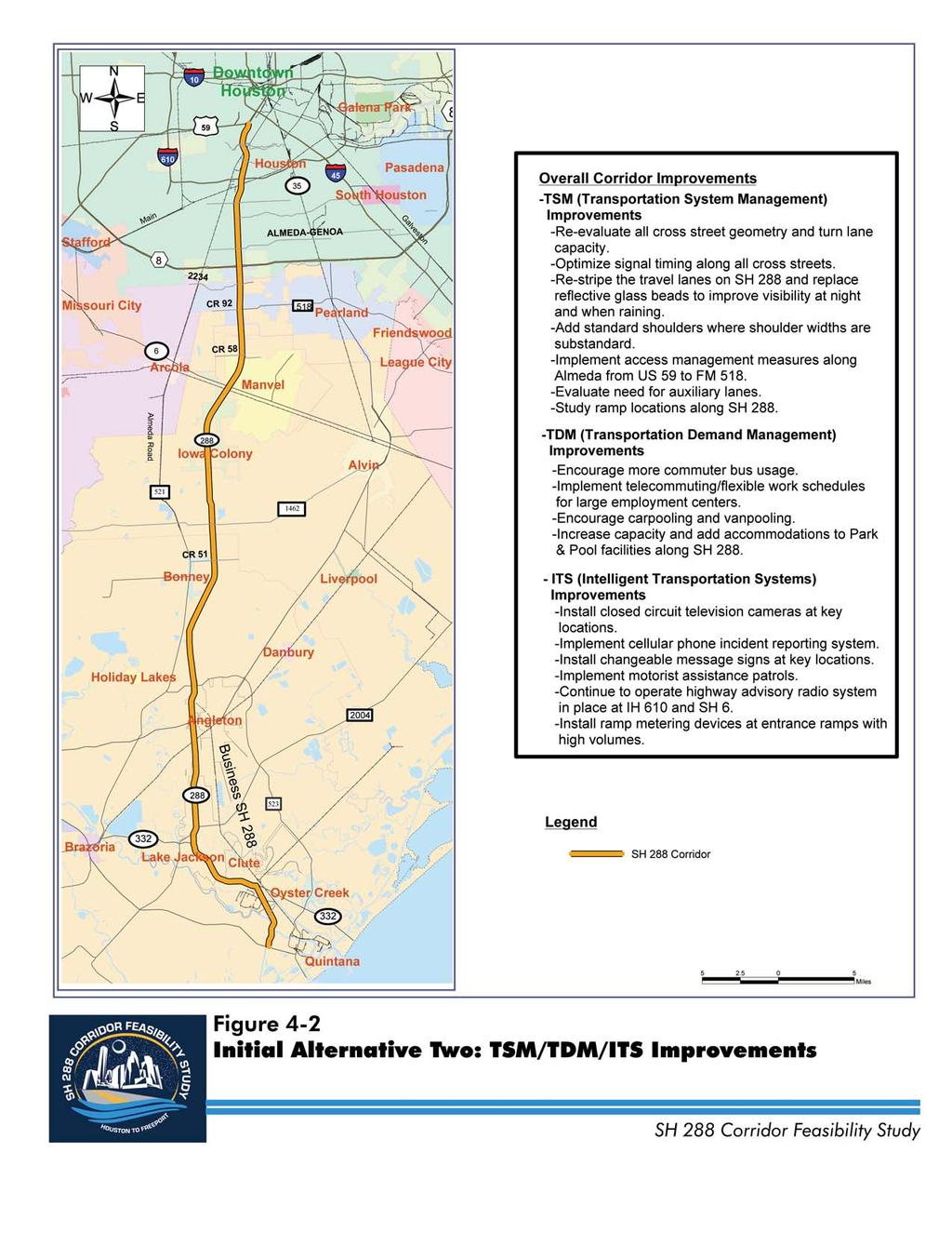
2 Chapter 4 Initial Alternative Two: Transportation System Management/Travel Demand Management/Intelligent Transportation System (TSM/TDM/ITS) Improvements As noted in Figure 4-2, this alternative includes relatively minor improvements that could be made to the SH 288 corridor to improve the efficiency and safety of the system. These cost effective measures do not require major capital investment, such as the addition of highway travel lanes or rail service. Transportation System Management (TSM) improvements improve traffic flow by making better use of the existing transportation system through provisions of intersection turn lanes, auxiliary lanes, and other geometric improvements, coordinated signal systems that efficiently meet travel demands, effective use of traffic control devices, lane channelization, and turn restrictions. Transportation Demand Management (TDM) measures offer a set of strategies and programs that encourage commuters to use alternatives to driving alone, especially during the periods of heaviest congestion. These strategies can contribute to reducing congestion along a corridor as they manage the demand placed on the transportation system. Potential TDM strategies along the SH 288 corridor include carpooling/vanpooling, enhanced Park and Pool lots, commuter buses and other forms of transit, telecommuting/flexible work hours, biking, walking, and parking management. An Intelligent Transportation System (ITS) uses technology to monitor traffic operations, detect incidents, and communicate conditions to the traveling public. These individual components are linked together primarily through a fiber optic communications network. The communications network allows for quick response to real-time traffic Page 4-2 SH 288 Corridor Feasibility Study


3 Figure 4-1 Initial Alternative One: No Build
4

 Lanes General purpose lanes are those that most people are accustomed to lanes that are free for travel by everyone such as")

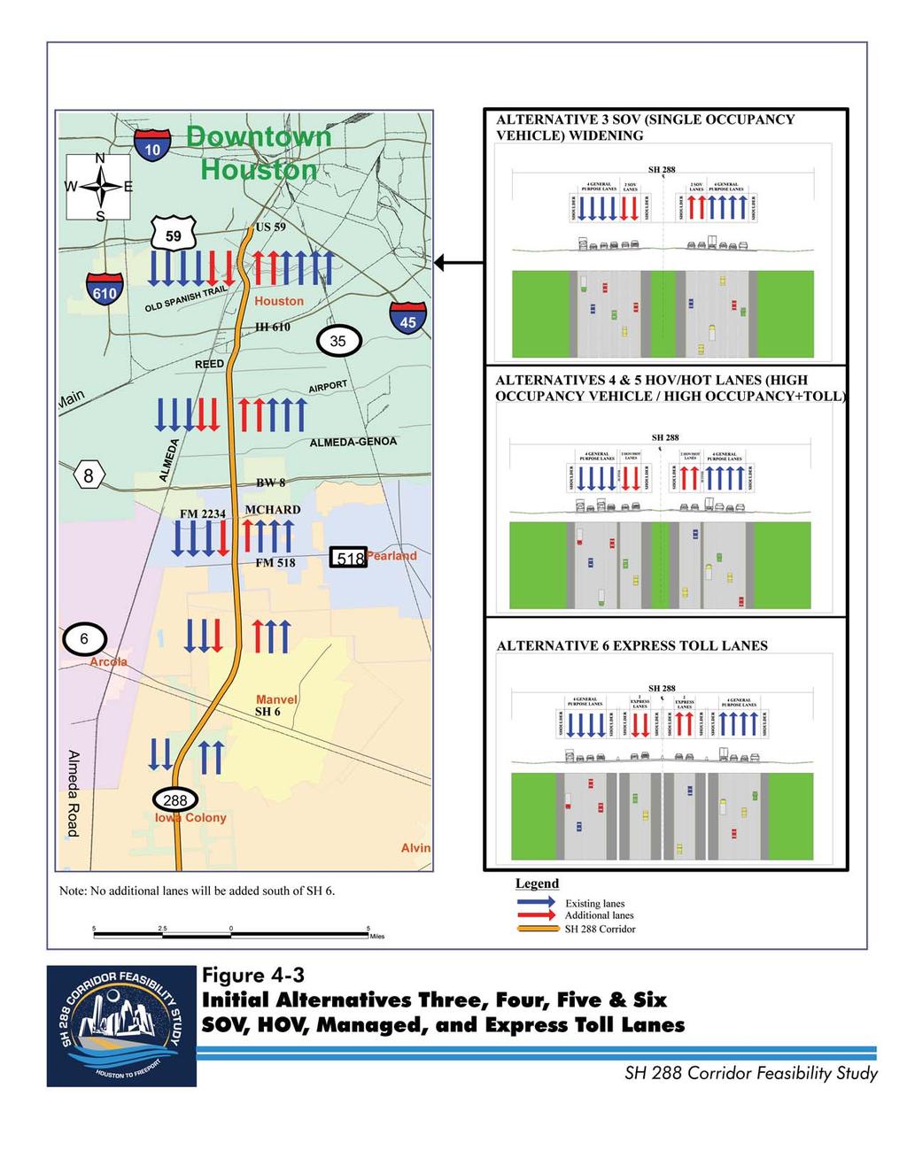
5 Initial Alternatives conditions. Candidate ITS improvements along the SH 288 corridor include closed circuit television cameras, cellular phone incident reporting, dynamic message signs, highway advisory radio, ramp metering, and motorist assistant patrol. Initial Alternative Three: General Purpose/Single Occupancy Vehicle (SOV) Lanes General purpose lanes are those that most people are accustomed to lanes that are free for travel by everyone such as the lanes that currently exist on SH 288. Alternative Three assumes the addition of two general purpose lanes in each direction from US 59 to Beltway 8 and one lane in each direction from Beltway 8 to SH 6, as indicated in Figure 4-3. The additional lanes are assumed to be constructed within the existing SH 288 median. Initial Alternative Four: High Occupancy Vehicle (HOV) Lanes HOV lanes are designed for exclusive use by vehicles such as buses, carpools, and vanpools with a certain number of occupants, typically two or more. The HOV lane operation in conjunction with Park and Pool and Park and Ride facilities encourages commuters to seek other means of transportation besides driving alone by reducing travel time for high occupancy vehicles. This alternative, shown in Figure 4-3, calls for the construction of two diamond (non-barrier separated) HOV lanes in each direction for use during all SH 288 Corridor Feasibility Study Page 4-3

6 Chapter 4 time periods from US 59 to Beltway 8 and one diamond lane in each direction from Beltway 8 to SH 6 to be separated from the existing mainlanes with a four foot buffer zone. Access to the HOV lanes would be limited to designated locations between US 59 and SH 6, similar to the existing configuration on IH 10 west of IH 610. Initial Alternative Five: Managed Lanes For this study, managed lanes are assumed to be high occupancy toll (HOT) lanes. The concept of managed lanes adds upon lanes that promote high occupancy vehicles (two or more people) by allowing people driving alone to also use these lanes for a fee. The flexibility of managed lanes allows for variations to better meet travel demand while providing increased choice for motorists. The toll rate on managed lanes can be variable based upon demand, as can the definition of a high occupancy vehicle. In addition to the benefits of increasing choice and managing congestion, the flexibility of managed lanes also generates revenue through tolls and the added efficiency maximizes the use of existing capacity. Alternative Five, shown in Figure 4-3, includes two managed lanes in each direction, separated by a four foot buffer zone between the existing SOV lanes, from US 59 to Beltway 8, and one buffer separated managed lane in each direction from Beltway 8 to SH 6. Initial Alternative Six: Express Toll Lanes Express Toll Lanes are specifically set aside and separated from other lanes for purposes of charging all users a toll for travel. Alternative Six, shown in Figure 4-3, includes the construction of barrier separated lanes and controlled access along SH 288 from US 59 to SH 6, and includes two express toll lanes from US 59 to Beltway 8 and one express toll lane from Beltway 8 to SH 6. Page 4-4 SH 288 Corridor Feasibility Study
7
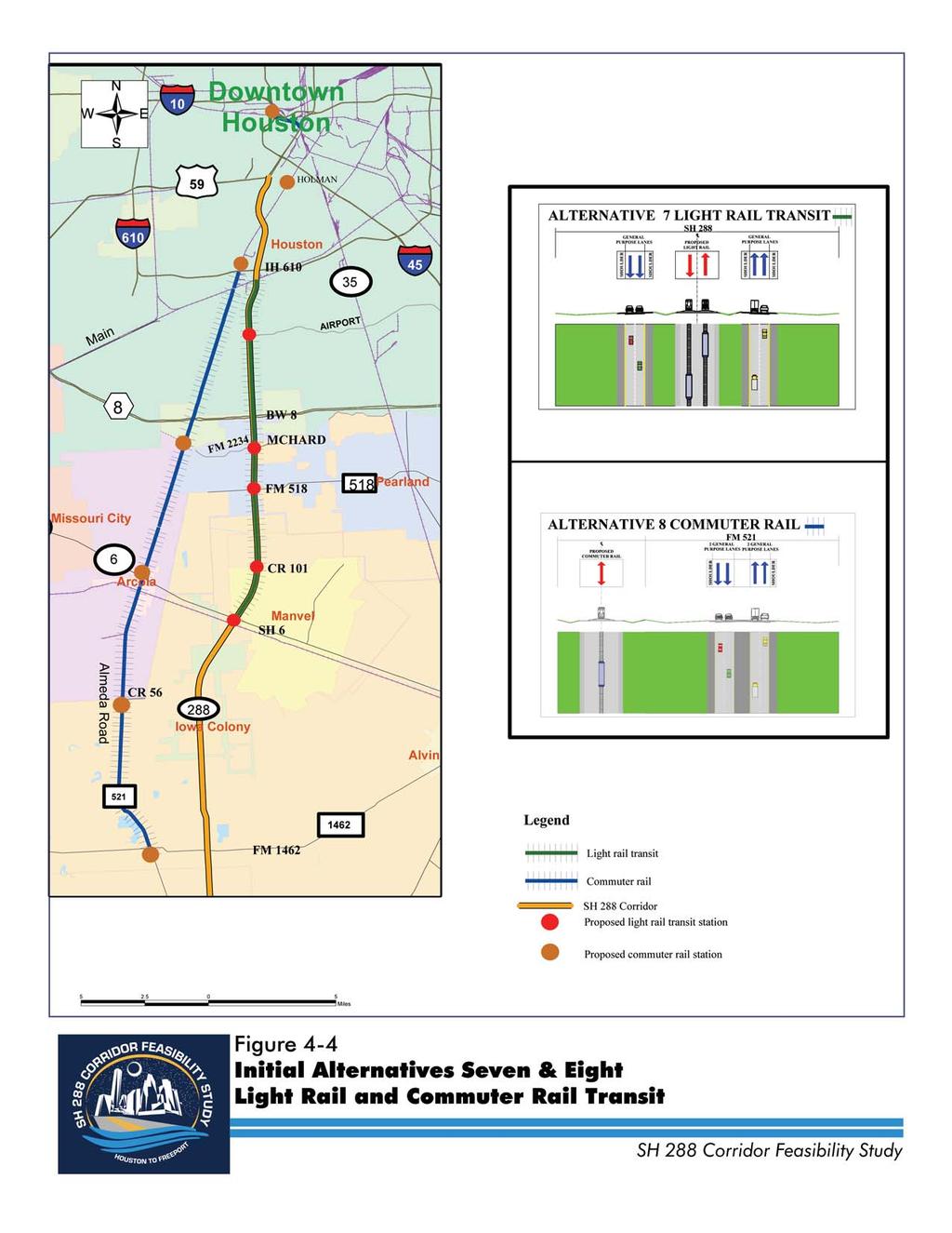
8 Initial Alternatives Initial Alternative Seven: Light Rail Light rail transit (LRT) is an urban electric railway system that builds upon the initial METRORail that began operations in January 2004 with a north-south line extending from the University of Houston to IH 610, serving Downtown Houston, the Texas Medical Center, and the Reliant Park/Astrodome area. Light rail transit is characterized by its ability to operate single cars or short trains along exclusive rights of way at ground level, on aerial structures, in subways, or occasionally in streets, and to board and alight passengers at track or car-floor level. This alternative would consist of light rail transit running from the southern terminus at the Fannin South station (located near the intersection of Fannin Street and West Bellfort Road) to the intersection of SH 288 and SH 6, as shown in Figure 4-4. For this initial evaluation, the light rail line was assumed to be located in the median of SH 288. Alternative alignments for the light rail alternative were considered in the detailed evaluation phase, which is discussed in the next chapter. Due to the relatively high cost of implementation, light rail transit as an initial alternative was proposed to be implemented in two phases. Phase I would occur between the Fannin South terminus of METRORail and FM 2234 (McHard Road). Stations are assumed to be located at Fannin South, Airport Road and FM 2234 (McHard Road). Phase II would occur along the SH 288 corridor and extend to SH 6. Stations are assumed to be located at FM 518, CR 101 and SH 6. Stations would interface with the bus system. Light rail has the added benefit of promoting more efficient land development in surrounding areas, known as transit-oriented development. Development surrounding a light rail station tends to be compact and walkable characterized by a comparatively dense mix of new residential and commercial establishments. SH 288 Corridor Feasibility Study Page 4-5
9 Chapter 4 Initial Alternative Eight: Commuter Rail Commuter rail is traditionally used for travel between suburbs and employment centers in the city and typically utilizes existing rail corridors. Trains can be locomotive-hauled or selfpropelled (electric or diesel) and are typically designed to carry a large number of people on relatively quick trips. Commuter rail typically operates on host (freight) railroad tracks, though in some cases the commuter rail operator may own the right-of-way. Commuter rail stops commonly attract riders from a large area, especially if parking and some feeder bus services are provided to offset the relatively low numbers within walking distances of the stations. For this initial evaluation, this alternative proposes to take advantage of the former and existing UP railroad rights-of-way between Holmes Road and FM 1462 just north of Bonney, as shown in Figure 4-4. This route would be adjacent and on the west side of FM 521 (Almeda Road) from FM 1462 to FM 2234 (McHard Road), and continues on the east side of FM 521 (Almeda Road) north to IH 610. The commuter train would terminate at the Fannin South METRO light rail station, providing riders a cross platform transfer to light rail trains. Five rail stations were assumed to be located at Holmes Road (connecting to an extended METRO rail system), FM 2234 (McHard Road), SH 6, CR 56, and FM Each station would have available parking, space for public transit feeder routes, and facilities for waiting passengers. As with light rail transit, commuter rail may promote transit-oriented development adjacent to the rail station. Initial Alternative Nine: Truck Lane A travel lane exclusively dedicated to trucks along SH 288 would increase highway capacity and improve safety by separating truck traffic from automobiles. It would also reduce maintenance on non-truck lanes relieved of the significantly heavier loads. As shown in Figures 4-5, Alternative Nine would include the construction of one barrier separated lane on SH 288 in each direction exclusively for truck traffic from IH 610 to FM 523 in Angleton. This alternative Page 4-6 SH 288 Corridor Feasibility Study
10

11 Figure 4-5 Initial Alternative Nine: Truck Lane
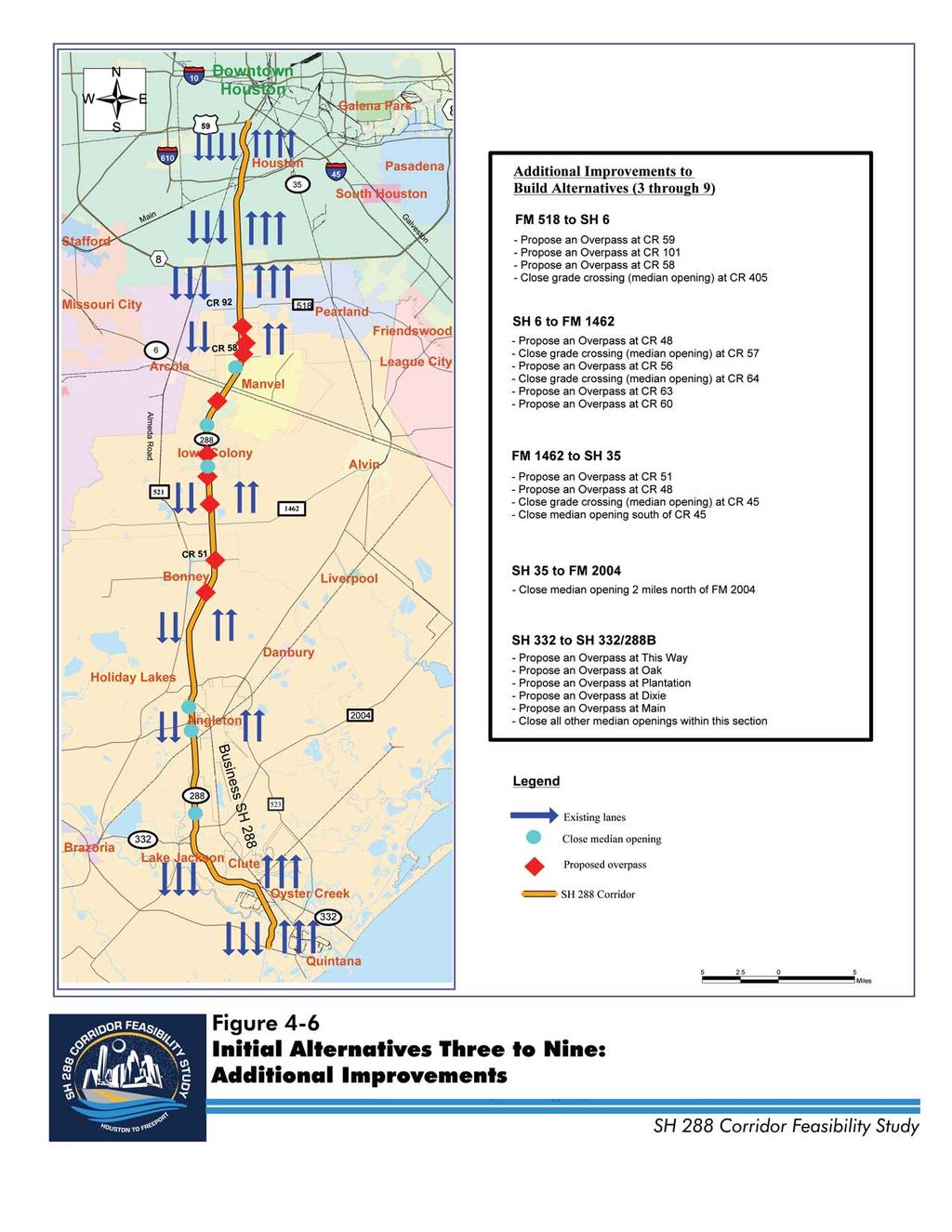
12 Initial Alternatives also includes the widening and improvement of FM 523 between SH 288 and FM 1495 to accommodate and encourage the diversion of truck traffic around the Cities of Angleton, Lake Jackson, and Clute. Additional Improvements All of the Build Alternatives (Alternatives 3 through 9), assume the upgrade of SH 288 to a freeway facility throughout its entire length. This would require the elimination of at-grade intersections and construction of grade separations (overpasses/underpasses) between FM 518 to Main Street in Clute. Potential locations for new grade separations and median crossings closings, which were assumed for this study, are shown in Figure 4-6. The actual locations of these intersection improvements will be determined in future project development and design phases. EVALUATION OF INITIAL ALTERNATIVES Evaluation criteria used for the screening evaluation of the initial alternatives are listed in Table 4-1. The nine initial alternatives were examined and evaluated according to four major areas of consideration: Traffic/Mobility, including criteria that relate to the movement of traffic, safety issues, level-of-service, travel time savings, improved accessibility, and multimodal compatibility; Environmental/Socioeconomic, including criteria involving business and residential relocations and environmental resources affected; Engineering/Cost, including criteria involving the amount of right-of-way required, utilities, and constructability consideration and costs associated with right-of-way, construction, operation and maintenance, and environmental mitigation; and, Public Involvement, including consideration as to whether a particular alternative was identified as one being favorable to the public. SH 288 Corridor Feasibility Study Page 4-7
13 Chapter 4 Each initial alternative was evaluated against the screening criteria as having favorable, neutral (or minor), or unfavorable impacts (with the exception of slightly different terminology applied to the environmental evaluation). To maintain the general nature of this initial examination, no weighting was added to any particular category of examination. The overall results of this initial screening evaluation led to the selection of Viable Alternatives warranting more intense examination and possible incorporation into a Most Feasible Alternative, which is discussed in the following chapters. Traffic and Mobility Impacts The following criteria were used to evaluate the alternatives in regards to their traffic impacts and ability to improve mobility along the SH 288 corridor: Vehicle Miles Traveled (VMT); Vehicle Hours Traveled (VHT); Level-of-Service (LOS); Travel Speed; Traffic Utilization; Table 4-1 Evaluation Criteria TRAFFIC/MOBILITY Criteria Travel Time Level-of-Service Traffic Utilization Vehicle Miles Traveled/Vehicle Hours Traveled Multimodal Compatibility Conformance with Regional Transportation Plans ENVIRONMENTAL/SOCIOECONOMIC Criteria Land Acquisition and Displacements Section 4(f) Lands Noise Impacts Social and Economic Impacts Environmental Justice Air Quality Vegetation and Wildlife Habitat Endangered Species Wetlands Water Quality Floodplains Hazardous Materials ENGINEERING/COST Criteria Right-of-Way Constructability Cost Safety Utilities Drainage PUBLIC INVOLVEMENT Criteria Public Input Page 4-8 SH 288 Corridor Feasibility Study
14
15 Initial Alternatives Multimodal Compatibility; and, Conformance with Regional Transportation Plans. This initial evaluation of traffic and mobility impacts utilized and refined base Year 2002 and future Year 2025 travel demand models developed by the Houston-Galveston Area Council (H-GAC) for their regional transportation planning activities. Technical Memorandum No. 3 Traffic Modeling Methodology describes the travel forecasting methods, assumptions, model components, and supporting analytical procedures that were applied for the evaluation of alternatives for this project. Vehicle Miles Traveled (VMT)/Vehicle Hours Traveled (VHT) Daily vehicle travel is measured according to total vehicle miles of travel (VMT) and is a function of traffic volume and travel distance. VMT represents the length of vehicle trips and the distance motorists travel to get to their destination. Total daily vehicle hours of travel (VHT) is a function of traffic volume, speed, and distance that represents total travel time and time motorists spend traveling in their vehicles. The impact of initial alternatives can be determined by comparing VMT to VHT. Level-of-Service (LOS) Level-of-service (LOS) measures typical traffic conditions by comparing traffic volume (demand) to roadway capacity (supply). LOS is ranked based upon the ability of roadway capacity to accommodate demand from letter A which represents free-flow traffic conditions through F which indicates heavily congested traffic flows. LOS D is typically considered the threshold of acceptable traffic conditions in an urban area. Initial Alternatives were compared according to their ability to increase the capacity of the SH 288 corridor in order to meet projected travel demands. Average Travel Speed Faster travel speeds indicate improvements in the overall quality of service along the corridor including reduced congestion and increased efficiency. Initial SH 288 Corridor Feasibility Study Page 4-9
16 Chapter 4 Alternatives were compared according to their impact upon travel speeds between Years 2000 and Traffic Utilization An Initial Alternative would only be effective if it is used. Traffic utilization evaluated the ability of each Initial Alternative to generate demand (taking away demand and congestion on existing lanes). Future traffic demand was evaluated in terms of average daily traffic volumes for vehicle travel lanes for those alternatives that include SH 288 highway improvements and average daily person trips for rail options. Multimodal Compatibility The provision of alternative transportation modes and choices is an important component of improvements to the SH 288 corridor. The ability to travel or move seamlessly between walking, biking, transit, and automobile travel plays a major role in an individual s ability to combine modes of transportation. Each Initial Alternative was examined according to the ability to provide and facilitate different modes of transportation, encourage transit ridership, and compatibility with METRO s 2025 Solutions. Conformance with Regional Transportation Plans Each Initial Alternative was ranked on the ability to support numerous transportation and land use plans in the SH 288 area. Types of plans examined included comprehensive land use and thoroughfare plans for the different communities along the SH 288 corridor, H-GAC s 2025 Regional Transportation Plan, METRO Solutions, and various other area studies for SH 35, Texas Medical Center, and Grand Parkway. Table 4-2 shows the traffic and mobility ratings for the Universe of Alternatives. Traffic and Mobility Impacts Summary Initial Alternative 1 (No Build) received an overall rating of unfavorable as a result of its poor performance in regard to improved travel time, LOS, Page 4-10 SH 288 Corridor Feasibility Study
17 Initial Alternatives VMT/VHT, multimodal, and conformance with regional plans. Alternative 1 does not provide any traffic/mobility benefits along the SH 288 corridor. Initial Alternative 2 (TSM/TDM/ITS) received an overall rating of neutral with neutral ratings for VMT/VHT, traffic utilization, multimodal and conformance, as well as unfavorable ratings for LOS and travel speed. The SH 288 corridor under Alternative 2 is projected to operate at LOS E/F which does not adequately accommodate the future traffic demand generated by the population and employment growth in the study area. However, this alternative would encourage and support carpooling and vanpooling. Initial Alternative 3 (SOV) scored an overall rating of favorable based upon Table 4-2 Traffic and Mobility Ratings for the Initial Alternatives Alternative 1. No Build 2. TSM/TDM/ITS 3. SOV Lanes 4. HOV Lanes 5. Managed Lanes 6. Express Toll Lanes 7. Light Rail 8. Commuter Rail 9. Truck Lane - Favorable - Neutral - Unfavorable four favorable ratings for VMT/VHT, LOS, traffic utilization, and conformance; although it also received an unfavorable rating for multimodal. Alternative 3 accommodates additional travel demands with its added capacity and acceptable operating conditions. However, this alternative does not provide significant travel time savings with its addition of general purpose lanes. Vehicle speeds in mixed-flow lanes will eventually return to their original levels due to the effects of latent demand, shifts from parallel routes and induced travel. The majority of the transportation plans in the study area supported additional capacity improvements along SH 288. VMT/VHT LOS Travel Speed Traffic Utilization Multimodal Conformance Overall Rating SH 288 Corridor Feasibility Study Page 4-11
18 Chapter 4 Initial Alternative 4 (HOV) scored an overall rating of favorable including favorable ratings for all six traffic/mobility criteria. Alternative 4 generally includes the same travel benefits with the SOV alternative. In addition, this alternative provides additional choices of lane and modes of travel (single occupant vehicles, carpools, vanpools, bus) thus increasing its usage and providing faster travel speeds along the HOV lanes. Another benefit is it increases the capacity of the original SH 288 travel lanes for single-occupancy vehicles by diverting high-occupancy vehicles to the new HOV lanes. Initial Alternative 5 (Managed) received the same evaluation ratings as Alternative 4, which would result in better usage than the HOV alternative by attracting additional single-occupancy vehicles in the new high-occupancy toll lanes for those who are willing to pay a toll. Initial Alternative 6 (Express Toll) scored an overall rating of favorable because of its favorable impacts for VMT/VHT, LOS, travel speed, and traffic utilization compared to the one unfavorable impact related to multimodal. Alternative 6 improves the overall performance of the corridor with respect to usage and traffic mobility by providing better travel speeds. However, this alternative does not encourage multimodal transportation such as carpool, vanpool, and bus transit. Initial Alternative 7 (Light Rail) and Initial Alternative 8 (Commuter Rail) scored an overall rating of neutral because each received neutral ratings for VMT/VHT, traffic utilization, and conformance; as well as unfavorable ratings for LOS and travel speed. Naturally, each was considered favorable for multimodal travel. Both of these alternatives do little to adequately accommodate traffic growth and relieve congestion on SH 288, but do provide the study corridor and Houston region with another mode of transportation with likely tangible benefits for the metropolitan area. Initial Alternative 9 (Truck Lane) scored an overall rating of neutral based upon four neutral scores (VMT/VHT, LOS, traffic utilization, and conformance). This alternative provides multimodal opportunities on the corridor by diverting truck traffic onto designated truck lanes thus relieving some congestion on the existing SH 288 general purpose lanes, enhancing the overall Port of Freeport container freight movement, and providing safer conditions by reducing truck traffic and automobile conflicts. Page 4-12 SH 288 Corridor Feasibility Study
19 Initial Alternatives Environmental and Socioeconomic Impacts A goal of the SH 288 Corridor Feasibility Study is to minimize impacts on socioeconomic and environmental conditions. To assist in this, the Initial Alternatives were screened with regard to their level of impact including little to no impact, slight to moderate impact, and moderate to substantial impact. Sensitive Areas Each Initial Alternative has the ability to impact those sensitive areas within and surrounding the SH 288 corridor based upon future traffic levels and proximity to sensitive sites. Sensitive areas include: Section 4(f) Lands; Noise; Air Quality; Vegetation and Wildlife Habitat; Endangered Species; Wetlands; and, Water Quality. Table 4-3 shows the environmental and socioeconomic ratings for the Universe of Alternatives. Community Cohesion Community cohesion is the network of ties that bind neighbors in a community. Elements of community cohesion may include civic associations, neighborhood stores, and children's play groups. The Initial Alternatives were examined according to the potential to impact community cohesion by impacting specific segments of the population, breaking up neighborhoods, displacing residences and businesses, or otherwise damaging neighborhood integrity. among other considerations. SH 288 Corridor Feasibility Study Page 4-13
20 Chapter 4 Table 4-3 Environmental and Socioeconomic Ratings for the Initial Alternatives Alternative Section 4(f) Noise Land Use Constraints Sensitive Areas Air Quality Vegetation & Wildlife Habitat Endangered Species Community Cohesion Land Use 1. No Build 2. TSM/TDM/ITS 3. SOV Lanes 4. HOV Lanes 5. Managed Lanes 6. Express Toll Lanes 7. Light Rail 8. Commuter Rail 9. Truck Lane - Favorable - Neutral - Unfavorable Existing land uses and natural conditions within the SH 288 corridor could make project development difficult. Land uses such as parks, wildlife refuges, and historic properties have special protection under Section 4(f) and are considered to be Sensitive Areas. Industry as a land use is not a constraint, but extensive industrial areas are difficult to relocate. Examination of each of the Initial Alternatives includes a relationship with existing land uses, floodplains, and sites that potentially contain hazardous materials. Wetlands Water Quality Social and Economic Environmental Justice Land Acquisition & Displacement Floodplains Hazardous Materials Overall Rating Page 4-14 SH 288 Corridor Feasibility Study
21 Initial Alternatives Environmental and Socioeconomics Summary Initial Alternative 1 (No Build) received an overall rating of little or no impact because it does not require additional land for right-of-way. Higher traffic volumes and increased congestion on the existing highway would result in slight to moderate impacts to noise and air quality receptors. Initial Alternative 2 (TSM/TDM/ITS) received an overall rating of little or no impact because most new facilities would be in the existing right-of-way. A small amount of additional land would be required for Park and Pool lots. Increased traffic volumes on the highway may affect noise and air quality receptors. Initial Alternatives 3 and 6 (SOV and Express Toll) received an overall rating of little or no impact because additional lanes would be added within the existing right-of-way, and Park and Pool lots would only require small amounts of additional land. Higher traffic volumes on the expanded highway would result in slight to moderate impacts to noise and air quality receptors. Initial Alternatives 4 and 5 (HOV and Managed) received an overall rating of slight to moderate impact because more additional land would be required for park and ride lots than the Park and Pool expansions outside the existing right-of-way. The Park and Ride lots may affect wetlands at County Road 45 and at FM Higher traffic volumes may result in slight to moderate impacts to noise and air quality receptors. Initial Alternative 7 (Light Rail) received an overall rating of slight to moderate impact because additional land would be required for stations and Park and Ride lots outside the existing right-of-way. Noise and air quality receptors would not likely benefit from this alternative because traffic levels on SH 288 would still increase. Initial Alternative 8 (Commuter Rail) received an overall rating of slight to moderate impact because land would be required for parking lots and stations, and right-of-way would be reclaimed along parts of the FM 521 (Almeda Road) corridor. The stations and parking lots would affect vegetation, wildlife habitat, and wetlands, especially at the crossings at Clear Creek, Mustang Bayou, and Austin Bayou. Noise and diesel air emissions would be introduced to receptors in Almeda, Arcola, and Rosharon, while traffic levels on SH 288 would not likely decrease. SH 288 Corridor Feasibility Study Page 4-15
22 Chapter 4 Initial Alternative 9 (Truck Lane) received an overall rating of slight to moderate impact because additional right-of-way would be required along FM 523. The acquisition of right-of-way would displace homes and businesses and affect vegetation and wildlife habitat along FM 523. Homes and businesses along FM 523 would also receive noise and air impacts resulting from higher traffic volumes along this route. Engineering and Cost Considerations Six engineering criteria were used to screen the Initial Alternatives: Right-of-Way; Constructability; Cost; Safety; Utilities; and, Drainage. Table 4-4 shows the engineering and cost ratings for the Universe of Alternatives. Right-of-Way Each of the Initial Alternatives was compared based upon the ability to minimize the amount of land required, although, in general, the SH 288 corridor has sufficient right-of-way to accommodate additional capacity improvements. Consideration was particularly given to the Table 4-4 Engineering and Cost Considerations Ratings for the Initial Alternatives Alternatives Right-of-Way Constructability Cost Safety Utilities Drainage Overall Rating 1. No Build 2. TSM/TDM/ITS 3. SOV Lanes 4. HOV Lanes 5. Managed Lanes 6. Express Toll Lanes 7. Light Rail 8. Commuter Rail* 9. Truck Lanes* - Favorable - Neutral - Unfavorable * Improvements in these Initial Alternatives included locations outside of the SH 288 corridor Page 4-16 SH 288 Corridor Feasibility Study
23 Initial Alternatives project timeline and state resources required to successfully complete any rightof-way acquisition process. Constructability Complexity of construction, including the impacts to traffic and businesses during construction, the need for road closures and detours, and the amount of disposable construction costs required for temporary pavement and traffic control measures are important factors in determining the viability of any alternative. Alternatives were examined according to the ability to provide optimum constructability and life-cycle costs. For example, a favorable rating would be warranted if construction has no or minimal impacts to existing traffic and businesses, and minimizes disposable construction costs. Cost Cost was measured for each of the Initial Alternatives based on a typical cost per mile for roadway, structure, rail lengths, right-of-way acquisition, and drainage facilities. While cost for major construction elements and right-of-way were considered, operation and maintenance costs were not included in this initial evaluation phase. Each alternative was examined according to it ability to provide improvements within the financial capacity of participating agencies. Safety Safety is important along this corridor from the standpoint of avoiding collisions and hazardous conditions, but also because the route is used for evacuating coastal areas when needed. Safety was measured for each Initial Alternative by evaluating the ability to conform to current TxDOT design standards, as well as address at-grade intersections, railroad crossings and the capacity for emergency evacuation. An alternative would receive a favorable rating if design standards were met, the number of at-grade intersections and railroad crossings reduced, and the emergency evacuation route capacity was improved. Utilities Each of the Initial Alternatives was compared based upon the impact upon the utility system. Relocations or adjustments to utilities contribute to overall SH 288 Corridor Feasibility Study Page 4-17
24 Chapter 4 project cost and reduce the viability of the alternative. A favorable rating would require minimal, if any, impact upon utilities within the SH 288 corridor. Drainage Drainage was measured for each alternative according to its ability to assist the storm water conveyance system (including pipes and swales) in meeting current design standards and addressing drainage issues for an emergency evacuation scenario. Improved drainage results in a safer traveling environment while also improving some conditions within the surrounding area. Engineering and Cost Considerations Summary Initial Alternative 1 (No Build) received an overall rating of neutral because the favorable ratings for right-of-way, cost, and utilities cancelled out the unfavorable ratings for constructability, safety, and drainage. By replacing pavement but not adding any additional capacity to SH 288, Alternative 1 minimizes right-of-way required, construction cost, and utility relocations. Alternative 1 has significant impacts to existing traffic and businesses, significant disposable construction costs, does not improve safety, and does not upgrade the drainage system. Initial Alternative 2 (TSM/TDM/ITS) received an overall rating of neutral as a result of only three favorable ratings (right-of-way, cost, and utilities), compared to two unfavorable ratings (constructability and drainage). The improvements in Alternative 2 minimize right-of-way required, cost, and utility relocations. Alternative 2 provides some safety improvements but has moderate impacts to existing traffic and businesses, significant disposable construction costs, a moderate construction cost, and does not upgrade the drainage system. Initial Alternative 3 (SOV Lanes) received an overall rating of favorable due to favorable ratings in regards to right-of-way, safety, utilities, and drainage and no unfavorable ratings. Constructing SOV lanes within the existing right-of-way improves safety, minimizes impacts to existing utilities, and upgrades the drainage system. Construction has a moderate impact on existing traffic and businesses and the cost is in the moderate range. Initial Alternative 4 (HOV Lanes) received an overall rating of favorable because it received three favorable ratings (safety, utilities, and drainage) and Page 4-18 SH 288 Corridor Feasibility Study
25 Initial Alternatives no unfavorable ratings. Constructing HOV lanes and upgrading SH 288 to current design standards improves safety, has a minimal impact on utilities, and upgrades the drainage system. Some right-of-way is required for Park and Ride lots. Construction has moderate impacts to existing traffic and businesses, moderate disposable construction costs, and a moderate construction cost. Initial Alternative 5 (Managed Lanes) received an overall rating of favorable in a manner similar to Initial Alternative 4. Initial Alternative 6 (Express Toll Lanes) received an overall rating of favorable in a manner similar to Initial Alternative 5. Initial Alternative 7 (Light Rail) received an overall rating of neutral because three favorable ratings (safety, utilities, and drainage) were offset by two unfavorable ratings (constructability and cost). Constructing light rail in the median and upgrading SH 288 to current design standards improves safety, has a minimal impact on utilities, and upgrades the drainage system. A moderate amount of right-of-way is needed for light rail stations. Construction has significant impacts to existing traffic and businesses and significant disposable construction costs. The cost of Light Rail is in the high range. Initial Alternative 8 (Commuter Rail) received an overall rating of neutral with three neutral ratings (cost, safety, and utilities) and two unfavorable ratings (right-of-way and constructability). Constructing commuter rail along FM 521 (Almeda Road) and upgrading SH 288 to current design standards will upgrade the drainage system. The cost is in the moderate range, safety will be improved along SH 288 but numerous additional at-grade rail crossings will be added, and construction would have moderate impacts on existing utilities. A significant amount of additional right-of-way needs to be acquired for the implementation of Alternative 8. Construction has significant impacts to existing traffic and businesses, and significant disposable construction costs. SH 288 Corridor Feasibility Study Page 4-19
26 Chapter 4 Initial Alternative 9 (Truck Lane) received an overall rating of neutral based upon favorable ratings for safety and drainage, and unfavorable ratings regarding right-of-way, constructability, and cost. Constructing truck lanes in the median of SH 288 and widening FM 523 from two to four lanes improves safety and upgrades the drainage system. Construction will have a moderate impact on utilities because of construction on FM 523 within newly acquired right-of-way. Construction has significant impacts to existing traffic and businesses, and significant disposable construction costs. The cost of construction is in the high range and has the highest cost of all of the alternatives. Summary of Initial Evaluation Results Considering all the evaluation criteria, the following Initial Alternatives received a favorable rating: Alternative 2 (TSM/TDM/ITS), Alternative 3 (SOV lanes), Alternative 4 (HOV lanes), Alternative 5 (Managed lanes), and Alternative 6 (Express Toll lanes). Table 4-5 shows the overall ratings for the Initial Alternatives. The following is a summary of findings by evaluation category: Public Acceptance The majority of the public comments received on the Initial Alternatives favored interim, low cost improvements (TSM/TDM/ITS) and the build alternatives that did not have an associated user fee Table 4-5 Overall Ratings for the Initial Alternatives Alternatives Public Acceptance Traffic & Mobility Environmental & Socioeconomic Engineering & Cost Overall Rating 1. No Build 2. TSM/TDM/ITS 3. SOV Lanes 4. HOV Lanes 5. Managed Lanes 6. Express Toll Lanes 7. Light Rail 8. Commuter Rail 9. Truck Lanes - Favorable - Neutral - Unfavorable Page 4-20 SH 288 Corridor Feasibility Study
27 Initial Alternatives (SOV and HOV). The rail alternatives (both commuter and light rail) also received strong public support. Traffic/Mobility The alternatives that increased capacity and provided an improved level-of-service and reduced congestion (SOV, HOV, Managed, and Express Toll) received favorable ratings, while the rail and truck lane alternatives did not significantly improve overall travel time along the SH 288 corridor. Engineering/Cost - The alternatives that received a favorable rating (SOV, HOV, Managed, and Express Toll) performed well generally in all engineering/cost categories. The remaining alternatives (No Build, TSM/TDM/ITS, Light and Commuter Rail, and Truck Lane) received a neutral rating due to high costs, and constructability and right-of-way issues. Environmental/Socioeconomic The alternatives that rated favorably included those that did not take any or very little additional right-of-way or resulted in minimal land use and environmental impacts (No Build, TSM/TDM/ITS, SOV, and Express Toll), while the remaining alternatives received a neutral rating. SH 288 Corridor Feasibility Study Page 4-21