RAILROAD COMMISSION OF TEXAS OIL & GAS DIVISION
|
|
|
- Delphia Black
- 5 years ago
- Views:
Transcription
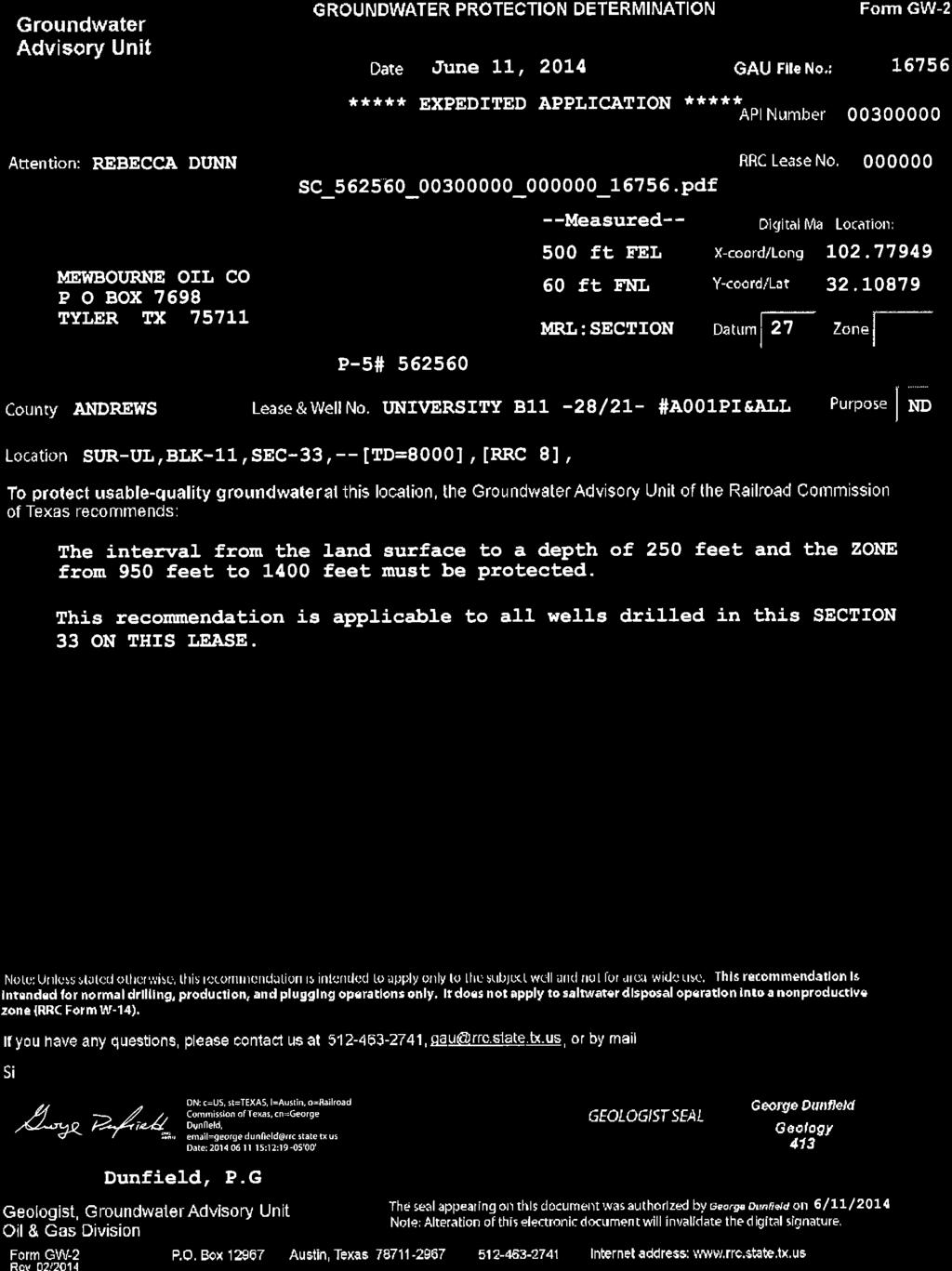
1 API No. Drilling Permit # SWR Exception Case/Docket No (R37) 6. Purpose of filing (mark ALL appropriate boxes): 7. Wellbore Profile (mark ALL appropriate boxes): 11. RRC District No GENERAL INFORMATION 8. Total Depth 9. Do you have the right to develop the 8000 minerals under any right-of-way? SURFACE LOCATION AND ACREAGE INFORMATION County 23. Is this a pooled unit? Yes X No 24. Unitization Docket No: APPLICATION FOR PERMIT TO DRILL, RECOMPLETE, OR RE-ENTER This facsimile W-1 was generated electronically from data submitted to the RRC. A certification of the automated data is available in the RRC's Austin office. X RAILROAD COMMISSION OF TEXAS 1. RRC Operator No. 2. Operator's Name (as shown on form P-5, Organization Report) 3. Operator Address (include street, city, state, zip): BOX Lease Name 5. Well No. TYLER, TX X New Drill Recompletion Reclass Field Transfer Re-Enter Amended Yes No Amended as Drilled (BHL) (Also File Form W-1D) ANDREWS 13. Surface Location X Land Bay/Estuary X Yes FORM W-1 07/ This well is to be located 19.9 miles in a SW direction from Andrews which is the nearest town in the county of the well site. 15. Section 16. Block Survey Vertical UL X Horizontal (Also File Form W-1H) 10. Is this well subject to Statewide Rule 36 (hydrogen sulfide area)? 18. Abstract No. A-U353 Directional (Also File Form W-1D) Inland Waterway 19. Distance to nearest lease : 330 ft. Permit Status: 21. Lease Perpendiculars: 60 ft from the N OFF LEASE and 500 ft from the E OFF LEASE. 22. Survey Perpendiculars: 60 ft from the NORTH and 500 ft from the EAST. Offshore No Approved Sidetrack 20. Number of contiguous acres in lease, pooled unit, or unitized tract: Are you applying for Substandard Acreage Field? Yes (attach Form W-1A) X No FIELD INFORMATION List all fields of anticipated completion including Wildcat. List one zone per. 26. RRC District No. 27. Field No. 28. Field Name (exactly as shown in RRC records) 29. Well Type 30. Completion Depth 31. Distance to Nearest Well in this Reservoir 32. Number of Wells on this lease in this Reservoir WILDCAT Oil or Gas Well ANDECTOR (WICHITA ALBANY) Oil Well BOTTOMHOLE LOCATION INFORMATION is required for DIRECTIONAL, HORIZONTAL, AND AMENDED AS DRILLED PERMIT APPLICATIONS Remarks [FILER Jun 4, :14 PM]: Surface location is off-lease. Offset list attached. SWD #2H, 2612' from this well is in the Three Bar (San Andres) field. RRC Use Only Data Validation Time Stamp: Oct 28, :47 PM( Current Version ) Page 1 of 2 Certificate: I certify that information stated in this application is true and complete, to the best of my knowledge. Rebecca Dunn, Consultant Name of filer (806) Phone (see W-1H attachment) Jun 04, 2014 Date submitted radunn@cableone.net Address (OPTIONAL)
2 Permit Status: Approved The RRC has not approved this application. Duplication or distribution of information is at the user's own risk. RAILROAD COMMISSION OF TEXAS APPLICATION FOR PERMIT TO DRILL, RECOMPLETE, OR RE-ENTER This facsimile W-1 was generated electronically from data submitted to the RRC. A certification of the automated data is available in the RRC's Austin office. 07/2004 Form W-1H Supplemental Horizontal Well Information Permit # Approved Date: Aug 19, RRC Operator No. 2. Operator's Name (exactly as shown on form P-5, Organization Report) 3. Lease Name Lateral Drainhole Location Information 5. Field as shown on Form W-1 6. Section 7. Block 8. Survey 9. Abstract 10. County of BHL UL ANDREWS 11. Terminus Lease Line Perpendiculars 330 ft. from the North. and 500 ft. from the East 12. Terminus Survey Line Perpendiculars 2345 ft. from the South. and 500 ft. from the East 13. Penetration Point Lease Line Perpendiculars 5. Field as shown on Form W-1 WILDCAT (Field # , RRC District 08) 410 ft. from the South. and 500 ft. from the East 6. Section 7. Block 8. Survey 9. Abstract 10. County of BHL UL ANDREWS 11. Terminus Lease Line Perpendiculars 330 ft. from the North. and 500 ft. from the East 12. Terminus Survey Line Perpendiculars 2345 ft. from the South. and 500 ft. from the East 13. Penetration Point Lease Line Perpendiculars ANDECTOR (WICHITA ALBANY) (Field # , RRC District 08) 410 ft. from the South. and 500 ft. from the East 4. Well No. Page 2 of 2
3 FIELD NAME ACRES DEPTH WELL # DIST LEASE NAME NEAREST LEASE NEAREST WE ** WILDCAT , WELLBORE PROFILE(s) FOR FIELD: Horizontal RESTRICTIONS: This is a hydrogen sulfide field. Hydrogen Sulfide Fields with perforations must be isolated and tested per State Wide Rule 36 and a Form H-9 filed with the district office. Fields with SWR 10 authority to downhole commingle must be isolated and tested individually prior to commingling production. Lateral: TH1 Penetration Point Location Lease Lines: F SOUTH L Terminus Location BH County: ANDREWS Section: 21 Block: 11 Abstract: Survey: UL Lease Lines: RAILROAD COMMISSION OF TEXAS PERMIT TO DRILL, DEEPEN, PLUG BACK, OR RE-ENTER ON A REGULAR OR ADMINISTRATIVE EXCEPTION LOCATION PERMIT NUMBER DATE PERMIT ISSUED OR AMENDED DISTRICT Aug 19, 2014 API NUMBER FORM W-1 RECEIVED COUNTY Jun 04, 2014 ANDREWS TYPE OF OPERATION OPERATOR LOCATION NEW DRILL BOX 7698 TYLER, TX LEASE NAME Section, Block and/or Survey WELLBORE PROFILE(S) Horizontal DISTANCE TO SURVEY LINES 60 ft. NORTH 500 ft. EAST DISTANCE TO LEASE LINES 60 ft. N OFF LEASE 500 ft. E OFF LEASE F NORTH L Survey Lines: F SOUTH L ** ANDECTOR (WICHITA ALBANY) , ACRES NOTICE This permit and any allowable assigned may be revoked if payment for fee(s) submitted to the Commission is not honored. District Office Telephone No: (432) DISTANCE TO NEAREST LEASE LINE 330 ft. DISTANCE TO NEAREST WELL ON LEASE See FIELD(s) Below FIELD(s) and LIMITATIONS: * SEE FIELD DISTRICT FOR REPORTING PURPOSES * ** THIS PERMIT IS GRANTED PURSUANT TO STATEWIDE RULE 37(h)(2)(A) ** CASE NO TOTAL DEPTH 19.9 miles SW direction from ANDREWS 8000 SECTION 33 BLOCK 11 ABSTRACT SURVEY UL WELL NUMBER U353 * Data Validation Time Stamp: Aug 19, :58 AM( Current Version ) Page 3 of 6
4 FIELD NAME ACRES DEPTH WELL # DIST LEASE NAME NEAREST LEASE NEAREST WE WELLBORE PROFILE(s) FOR FIELD: Horizontal RESTRICTIONS: This is a hydrogen sulfide field. Hydrogen Sulfide Fields with perforations must be isolated and tested per State Wide Rule 36 and a Form H-9 filed with the district office. Fields with SWR 10 authority to downhole commingle must be isolated and tested individually prior to commingling production. Lateral: TH1 Penetration Point Location Lease Lines: F SOUTH L Terminus Location BH County: ANDREWS Section: 21 Block: 11 Abstract: Survey: UL Lease Lines: Survey Lines: RAILROAD COMMISSION OF TEXAS PERMIT TO DRILL, DEEPEN, PLUG BACK, OR RE-ENTER ON A REGULAR OR ADMINISTRATIVE EXCEPTION LOCATION PERMIT NUMBER DATE PERMIT ISSUED OR AMENDED DISTRICT Aug 19, 2014 API NUMBER FORM W-1 RECEIVED COUNTY Jun 04, 2014 ANDREWS TYPE OF OPERATION OPERATOR LOCATION NEW DRILL BOX 7698 TYLER, TX LEASE NAME Section, Block and/or Survey WELLBORE PROFILE(S) Horizontal DISTANCE TO SURVEY LINES 60 ft. NORTH 500 ft. EAST DISTANCE TO LEASE LINES 60 ft. N OFF LEASE 500 ft. E OFF LEASE F NORTH L F SOUTH L ACRES NOTICE This permit and any allowable assigned may be revoked if payment for fee(s) submitted to the Commission is not honored. District Office Telephone No: (432) DISTANCE TO NEAREST LEASE LINE 330 ft. DISTANCE TO NEAREST WELL ON LEASE See FIELD(s) Below FIELD(s) and LIMITATIONS: * SEE FIELD DISTRICT FOR REPORTING PURPOSES * ** THIS PERMIT IS GRANTED PURSUANT TO STATEWIDE RULE 37(h)(2)(A) ** CASE NO TOTAL DEPTH 19.9 miles SW direction from ANDREWS 8000 SECTION 33 BLOCK 11 ABSTRACT SURVEY UL WELL NUMBER U353 * ' ** ' PRECEDING FIELD NAME INDICATES RULE (R37) THE FOLLOWING RESTRICTIONS APPLY TO ALL FIELDS This well shall be completed and produced in compliance with applicable special field or statewide spacing and density rules. If this well is to be used for brine mining, underground storage of liquid hydrocarbons in salt formations, or underground storage of gas in salt formations, a permit for that specific purpose must be obtained from Environmental Services prior to construction, including drilling, of the well in accordance with Statewide Rules 81, 95, and 97. Data Validation Time Stamp: Aug 19, :58 AM( Current Version ) Page 4 of 6
5 RAILROAD COMMISSION OF TEXAS PERMIT TO DRILL, DEEPEN, PLUG BACK, OR RE-ENTER ON A REGULAR OR ADMINISTRATIVE EXCEPTION LOCATION PERMIT NUMBER DATE PERMIT ISSUED OR AMENDED DISTRICT Aug 19, 2014 API NUMBER FORM W-1 RECEIVED COUNTY Jun 04, 2014 ANDREWS TYPE OF OPERATION OPERATOR LOCATION NEW DRILL BOX 7698 TYLER, TX LEASE NAME Section, Block and/or Survey WELLBORE PROFILE(S) Horizontal DISTANCE TO SURVEY LINES 60 ft. NORTH 500 ft. EAST DISTANCE TO LEASE LINES 60 ft. N OFF LEASE 500 ft. E OFF LEASE ACRES NOTICE This permit and any allowable assigned may be revoked if payment for fee(s) submitted to the Commission is not honored. District Office Telephone No: (432) DISTANCE TO NEAREST LEASE LINE 330 ft. DISTANCE TO NEAREST WELL ON LEASE See FIELD(s) Below FIELD(s) and LIMITATIONS: * SEE FIELD DISTRICT FOR REPORTING PURPOSES * ** THIS PERMIT IS GRANTED PURSUANT TO STATEWIDE RULE 37(h)(2)(A) ** CASE NO FIELD NAME ACRES DEPTH WELL # DIST LEASE NAME NEAREST LEASE NEAREST WE This well must comply to the new SWR 3.13 requirements concerning the isolation of any potential flow zones and zones with corrosive formation fluids. See approved permit for those formations that have been identified for the county in which you are drilling the well in TOTAL DEPTH 19.9 miles SW direction from ANDREWS 8000 SECTION 33 BLOCK 11 ABSTRACT SURVEY UL WELL NUMBER U353 * Data Validation Time Stamp: Aug 19, :58 AM( Current Version ) Page 5 of 6
6 RAILROAD COMMISSION OF TEXAS SWR #13 Formation Data ANDREWS (003) County Formation Shallow Top Deep Top Remarks Geological Order Effective Date YATES 2,500 3, /17/2013 SEVEN RIVERS 3,000 3, /17/2013 QUEEN 3,600 4, /17/2013 GRAYBURG 3,100 5, /17/2013 SAN ANDRES 3,700 5,300 CO2 flood, high flows, H2S, corrosive 5 12/17/2013 HOLT 5,000 5, /17/2013 GLORIETA 5,100 6, /17/2013 TUBB 6,100 6, /17/2013 CLEARFORK 5,600 7, /17/2013 PERMIAN 7,800 7, /17/2013 DETRITAL LEON 7,900 7, /17/2013 WICHITA 6,500 8, /17/2013 ALBANY SPRABERRY 7,300 8, /17/2013 DEAN 9,200 9, /17/2013 WOLFCAMP 7,500 9, /17/2013 CANYON 8,600 10, /17/2013 PENNSYLVANIAN 8,700 10, /17/2013 MCKEE 8,300 10, /17/2013 STRAWN 8,800 11, /17/2013 FUSSELMAN 8,400 11, /17/2013 DEVONIAN 7,600 12, /17/2013 SILURIAN 8,000 12, /17/2013 ELLENBURGER 7,900 13, /17/2013 This is a dynamic table that will be updated continuously. It is the operators responsibility to make sure that at time of spudding the well the most current table is being referenced.
7
8