Unmanned Aerial Systems (UAS) Desk and Derrick Club of Dallas May 3 rd, 2018
|
|
|
- Bruno Rogers
- 5 years ago
- Views:
Transcription
 Desk")

1 Unmanned Aerial Systems (UAS) Desk and Derrick Club of Dallas May 3 rd, 2018
2 Table of Contents Introduction to UASs Current Market Projections Oil and Gas Adoption FAA & Regulations Oil and Gas Applications

3 Unmanned Aerial Systems (UAS) A UAS or an Unmanned Aerial System is a miniature pilotless aircraft, which is either controlled by a remote or an app and uses aerodynamic forces to navigate and perform desired functions. They are used to carry small payloads, perform delivery and minor services, carry video and static cameras for photography and videography, and perform commercial and military inspections and operations.
 Fixed")
4 Unmanned Aerial Systems (UAS) Fixed Wings
")
5 Unmanned Aerial Systems (UAS) Multirotor Wings
6 Current Market Projections

7 Market Projection Goldman Sachs forecasts a $100B total market opportunity for UAS between , consisting of: 70B military 17B consumer 13B commercial/civil Current Total Addressable Market: Commercial The fastest growing will occur in the commercial & civil government markets The FAA expects commercial UAS units to jump from 600,000 in 2017 to 2.7 million in 2020
8 Existing Challenges Privacy: Policymakers must address the increasing privacy concerns resulting from the proliferation of UAS and associated surveillance payload technology. New regulatory, enforcement, and technology safeguards are needed to minimize risk to privacy and unauthorized surveillance. Certification: Given the broad array of new UAS applications and implications, FAA must develop a comprehensive and standardized certification requirements for hardware, software, operations, and operator to ensure safe and secure UAS operations. BVLOS Operations: Latest FAA UAS regulations (Part 107) prohibit BVLOS operations. Considering that majority of UAS use cases and applications require autonomous and BVLOS operations, FAA needs to develop regulations, air traffic management architecture, and sense and avoid requirements / technology to enable safe BVLOS operations in the NAS. Standards: Performance, Technical, Safety, Security and Operational standards are critical to ensuring consistent maturation and safe operations of this technology across various industries and sectors. Cybersecurity: UAS could become a new threat vector for cyber attacks. Nefarious actors and hackers can remotely hack into unmanned systems and take control to achieve nefarious and criminal means. Autonomous Operations: Existing technology, policy, process, and human capital challenges need to be addressed before autonomous operations become a reality. For example, an air traffic control architecture that manages all UAS traffic and ensure safe operations needs to be implemented and tested. UAS technology also needs to mature to incorporate sense and avoid solutions and autonomous decision-making. Interoperability: Developing common interoperability standards between and among UAS, manned aircraft and flight control systems is critical to creating collaborative solutions, streamlining costs, spurring R&D and maximizing the utility and effectiveness of future UAS. Federal Preemption: While federal aviation regulations traditionally preempt state and local law, drones present unique legal challenges. Federal, state and local governments must collaborate to avoid legal conflict and ambiguity that would limit the economic potential of UAS.
9 Oil and Gas Adoption


10 Why Use Drones? UAVs are well suited to meet the needs of operators across multiple applications due to a UAVs capabilities not not only visually assess assets, but to also gather and provider a variety of data sets. With majority of inspection done by foot, or via helicopter, utilizing UAVs to conduct assessments operators can greatly reduce the safety risk associated with Right-of- Way inspections.
11 Industry Adoption The use of UAVs are pushing the boundaries of the traditional industry methods that require extensive labor, time and resources. Drone increase efficiency, reduce cost and provide increasingly more precision, accurate data that improve overall ROI.
12 Third Party vs. Internal Use Initial capital expense Maintenance and technology advancement FAA regulations and insurance Integrating a new workflow to your current system Understanding the new data and utilizing it
13 FAA and Regulations
14 Section 333 & Part 107 Federal & Local UAS Regulations suas are required to be under 55 pounds Day time operations can be conducted 30 minute prior to sunrise and 30 minutes after sunset Night time operations can be conducted with prior approval Maximum speed is 100 mph Maximum altitude is 400 feet above the ground or structure You can t fly a suas over anyone who is not directly involved in the suas operation Operations in Class G airspace are allowed without air traffic coordination Must maintain visual line of sight at all times
15 Section 333 & Part 107 Federal & Local UAS Regulations (5) if the image is captured by or for an electric or natural gas utility: (A) for operations and maintenance of utility facilities for the purpose of maintaining utility system reliability and integrity; (B) for inspecting utility facilities to determine repair, maintenance, or replacement needs during and after construction of such facilities; (C) for assessing vegetation growth for the purpose of maintaining clearances on utility easements; and (D) for utility facility routing and siting for the purpose of providing utility service; (17) if the image is captured by the owner or operator of an oil, gas, water, or other pipeline for the purpose of inspecting, maintaining, or repairing pipelines or other related facilities, and is captured without the intent to conduct surveillance on an individual or real property located in this state; (18) in connection with oil pipeline safety and rig protection;
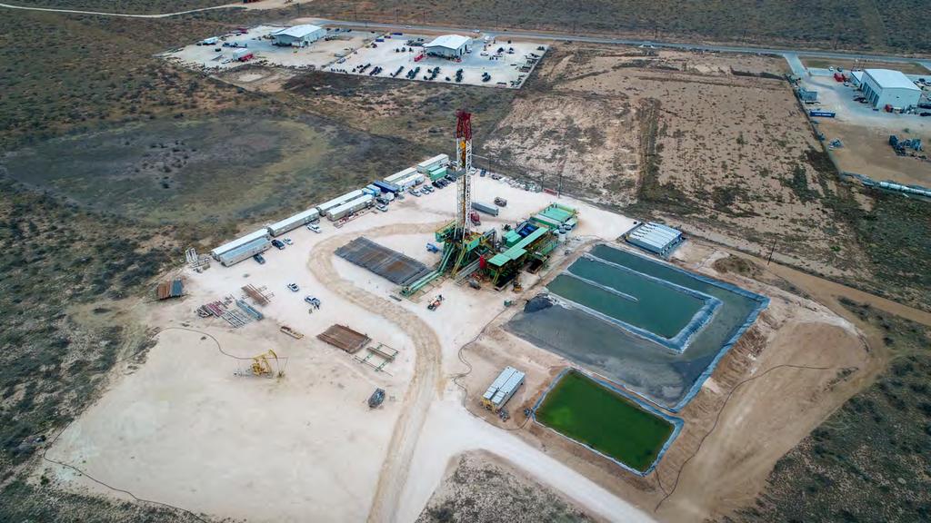
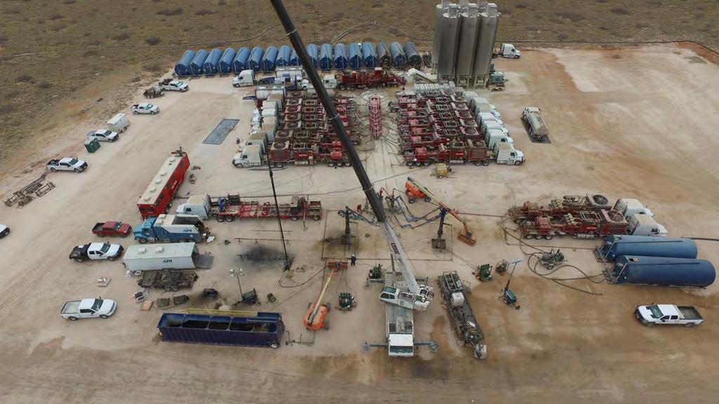
16 Oil and Gas Applications

17 Aerial Photography

18 Aerial Photography
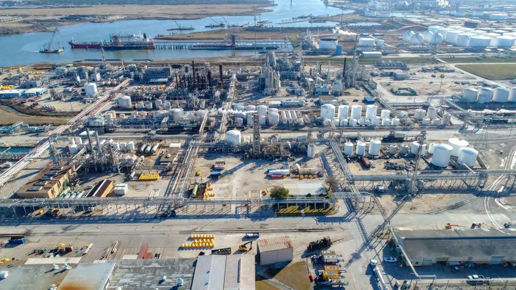
19 Facility Inspection
20 Facility Inspection
21 Facility Inspection

22 Facility Inspection Infrared and Thermal Imaging

23 Land Development 2D Mapping

24 Aerial Mapping 3D Modeling

25 Aerial Mapping 3D Modeling


26 Aerial Mapping 3D Modeling

27 Aerial Mapping 3D Modeling

28 Volumetric Analysis Petrochemical Coke
29 Aerial ROW Inspection 2D Mapping

30 Pipeline & ROW Inspection 2D Mapping

31 Emergency Response
32 Arch Aerial Questions? Danny Avant (281) archaerial.com 2016 ARCH AERIAL