Community Advisory Committee Meeting No. 2. June 22, 2006
|
|
|
- Marilynn Hines
- 5 years ago
- Views:
Transcription


1 Community Advisory Committee Meeting No. 2 June 22, 2006

2 Introductions The Study Team KDOT Wichita Partners Consultants CAC members
3 Overview Today s Agenda Opinion Survey Study Status Starting Concept Development Impact Identification and Prioritization Process Reminders Study Area and Tasks Schedule Overall CAC Meetings Public Meeting

4 Study Area and Tasks Boundaries Study Area I-235 between and including the interchanges of US-54/400 (Kellogg) and Central Avenue Influence Area Roughly bounded by arterials at next interchange upstream and downstream Tasks Regional Context Existing and Projected Conditions Purpose and Need Report Design Concepts Concept Study Report Recommendations
5 Study Schedule
6 Community Advisory Committee Meeting Topics 1. Guiding Principles (3/30/06) 2. Review of Existing Conditions (6/22/06) 3. Design Concept Review (10/26/06) 4. Design Concept Recommendation (Feb 07) 5. Phasing Plan Review (May 07) Today s Meeting Workshop Workshop
7 Public Engagement Public Meeting July 20, 2006 from 5 to 7 PM at the 4H Building Introductory presentation Open-House Displays Background Existing Conditions Under Consideration
8 Opinion Survey Purpose Designed to gather input from residents about issues related to potential improvements Methodology Random sample of 800 households by telephone 400 in immediate study area 200 in remainder of Wichita 200 outside of Wichita 95% confidence level with +/- 3.5% precision Conducted by ETC Institute
9 Opinion Survey - Respondents 67% have been driving I-235 for more than 10 years 78% drove I-235 between Kellogg and Central in the last month Reasons for traveling I-235 Shopping 48% Visiting 37% Work/business 34% Recreation/Entertainment 30% Medical/dental attention 23%

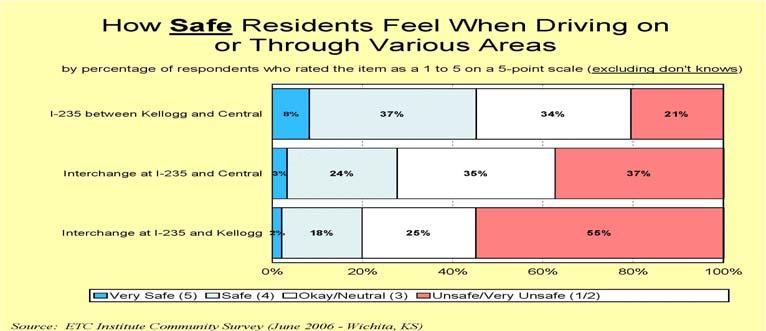
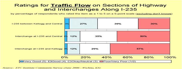
10 Opinion Survey Physical Conditions, Traffic Flow and Safety


11 Opinion Survey Ease getting on and off interchanges


12 Opinion Survey Importance of Issues

13 Opinion Survey Need for improvements
14 Future Opinion Survey Scheduled near end of study process Questions to test awareness, understanding, and satisfaction on concepts developed Effectively expands the base of public input
15 Study Status Study Elements Regional Context Existing Conditions Physical Corridor The Environment Transportation Projected Conditions (in progress) Utilize WAMPO s 2030 Travel Demand Model Assumptions on future transportation network Process, Process, Process
16 Regional Context Regional Transportation System Long Range Planning Multimodal Elements Existing and Proposed Transportation System Travel Demand Model Regional Trends Travel Characteristics


17 Regional Context Elements Other modes Transit, bicycles, pedestrians Wichita Valley Center Floodway Former railroad crossing Freight Mobility Truck route significance Airport Accessibility Expansion Utility Corridors Congestion Management Process Opportunities and Constraints Coordinate, Review and Maintain Emergency response Electrical Transmission Towers Fire truck traveling in opposing direction through I-235/Central
18 Existing Conditions Summary Condition Elements Physical Corridor Alignment and Conditions The Environment Natural and Built Transportation Capacity and Safety Analyses Purposes Assess existing needs and identify issues for consideration when developing concepts Assist in determining how best to utilize earmarked funds and program solutions
19 The Physical Corridor Elements Roadway Section Alignments Horizontal and Vertical Condition Assessment Pavement and Bridges Mobility Transit, Non-motorized and Access Management
 MEDIAN 12 to 23 feet wide with concrete")

20 Typical Sections I-235 MEDIAN - 60 foot wide LANE WIDTH (Dir) 2 x 12 SHOULDER Inside 6 Outside 10 US-54/400 (Kellogg) MEDIAN 12 to 23 feet wide with concrete barrier LANE WIDTH (Dir) 3 x 12 and 3 x 11 (east of I-235) SHOULDER Inside varies 4.5 to 10 Outside varies 4 plus curb and gutter 8 plus concrete barrier retaining wall
21 Assessing the Design Mainline (I-235 / US-54/400) Plan design speed 60/60 mph Existing posted speed 65/60 mph Desirable design speed 70/65 mph Interchange Ramps Three ranges for 65 mph highway design speed Upper range 55 mph Middle range 45 mph Lower range 30 mph Minimum 25 mph (loop ramp only)


22 Alignments - Mainline Horizontal I curves at 55 mph 1 curve at 60 mph US-54/400 > 70 mph Vertical I curve at 60 mph Crest at former railroad Maximum grade at 3.46% US-54/400 2 curves < 60 mph Maximum grade at 3.16%


23 Alignments Interchange Ramps Horizontal I-235 and US-54/400 Ramps Loop ramps constrained by former railroad are < 25 mph Limiting curves at both entry and exit areas Vertical I-235 and US-54/400 Ramps 2 grades > 7% Maximum 10% 2 sag curves in loop ramps are < 20 mph Limited sight distance 90 foot radius and 10% grade 15 mph warning
, Distress")

24 Conditions Pavement KDOT s Pavement Management Information System (PMIS) Various measures including: International Roughness Index (IRI), Distress State (DS) consisting of faulting, rutting and cracking, and Performance Level. Overall, condition is good with estimated remaining life consistently around 16 years

 in the high-80 s")


25 Conditions Bridges Thirteen bridges with features crossed including: Roads, former railroad and Wichita Valley Center Floodway Majority built in 1961 Majority have sufficiency index (SI) in the high-80 s to low-90 s which is good Exception with SI in high-60 s I-235 bridges over US-54/400 (Kellogg Ave.) and Two interchange ramp bridges across the Big Ditch Arterial vertical clearance restrictions Maple Street Central Avenue


 Considered a high")
26 Mobility Bus Stop/Bench On-road bicyclist Wichita Transit Bus routes along Central Avenue and Maple Street Non-motorized facilities For bicyclists For pedestrians Access Management Central Avenue Rate of nearly 60 access points per mile from Big Ditch to Flora (0.5 mile length) Considered a high rate Maple Street sidewalk/path on north side
27 The Environment Elements Reviewed Socioeconomic Factors Environmental Justice Demographics Land Use Emergency Services Public Lands Cultural Resources Water Quality Floodplain Wetlands Soil Erosion and Sedimentation Threatened and Endangered Species Geologic Resources Hazardous Waste Noise
28 The Environment Purpose at this stage of the study Identify issues Regulatory requirements Community concerns Design approach NEPA guidelines - Avoid, minimize, mitigate as necessary Address at appropriate time Study is NOT an environmental document Programmatic approach Levels of environmental documentation Categorical Exclusion Environmental Assessment Environmental Impact Statement Scheduling
29 Transportation Hourly Traffic Volumes I-235 AM Peak Hour Volumes I Southbound in the AM SB NB Northbound in the PM Peaks at 3,000 vph North of Zoo Btwn Central Btwn Kellogg and Zoo and Cent ral Bet ween K- 42 and Kellogg Sout h of K- 42 Central Avenue Location Eastbound in the AM I-235 PM Peak Hour Volumes Westbound in the PM Peaks just under 2,000 vph SB 1500 NB Central Avenue AM/PM Peak Hour Volumes EB WB 0 Nort h of Zoo Bt wn Cent ral Btwn Kellogg Bet ween K- and Zoo and Cent ral 42 and Kellogg Location South of K West of I-235 (AM) East of I-235 (AM) West of I-235 (PM) East of I-235 (PM) Locat ion
30 Transportation Hourly Traffic Volumes US-54/400 (Kellogg Ave.) Eastbound in the AM Westbound in the PM Peaks at approx. 5,800 vph Comparison by volume per lane US-54/400 (Kellogg Ave.) 1,900 vphpl I-235 1,500 vphpl Central Avenue 1,000 vphpl US-54/ 400 (Kellogg Ave.) AM Peak Hour Volumes West of Dugan Btwn Dugan and I- Between I-235 and East of West 235 West Locati on US-54/400 (Kellogg Ave.) PM Peak Hour Volumes West of Dugan Bt wn Dugan and I- Bet ween I-235 and East of West 235 West Location EB WB EB WB
31 Transportation Traffic Volumes Study Area Patterns I-235 and Kellogg Ramps Complimentary Exchanges AM» I-235 SB to US 54/400 EB PM» US 54/400 WB to I-235 NB I-235 and Central Ramps Complimentary Exchanges AM PM» Central EB to I-235 SB» I-235 NB to Central WB Vehicles per Hour Vehicles per Hour I-235 and Kellogg Peak Hour Ramp Volumes N-E W-S S-E W-N S-W E-N N-W E-S Ramp Exchanges by Direction I-235 and Central Peak Hour Ramp Volumes W-S E-S N-W N-E W-N E-N S-W S-E Ramp Exchanges by Direction AM PM AM PM
32 Transportation Capacity Analysis Assessed for AM and PM peak hours Types of Operations and Analysis Highway Mainline Weave/Merge Arterial Signalized intersections Unsignalized intersections Capacity Analysis Evaluation Methodology Different assessments for different types Level of Service (LOS) concept LOS A free flowing LOS B LOS C LOS D acceptable minimum LOS E LOS F unstable
33 Transportation Capacity Analysis (preliminary) Highway Operations Problem Areas (LOS E or worse) Mainline I-235» Northbound PM Weave/Merge I-235» Southbound Weave AM US-54/400 (Kellogg Ave.)» Eastbound Weave AM (I-235 loop ramps)» Eastbound Weave AM (I-235 and West)» Westbound Weave PM (West and I-235)


34 Transportation Capacity Analysis (preliminary) Arterials - signalized intersections Central Avenue Extensive queues Influence Area Analysis Three intersections Ridge NB & Kellogg EB LOS E, PM Zoo & Windmill LOS E, AM West & Pawnee LOS E, PM Operations do not spill over and affect study area Queues to ramp taper Queues past ramp nose I-235 NB Off-ramp to Central in PM Central, looking east
35 Transportation Safety Analysis Comparison of Accident Rates Standard deviation to determine critical rates For similar facilities by access control, location, and number of lanes Total length (all accidents) I-235 (4.4 miles) is less than critical statewide rate (1.20 vs 1.38) US 54/400 (1.5 miles) is higher than critical statewide rate (1.70 vs 0.84) 1/10 th of a mile segments Higher than critical rate in I-235/Kellogg interchange
36 Safety Analysis Accident Rates every 1/10 th mile Interstate 235 US-54/400 (Kellogg)


37 Safety Analysis Safety Analysis I-235 & Kellogg Data Reviewed Reports 22 June Blue 2006 PDO/Red Injury

38 Safety Analysis I-235 & Central Data Reviewed Reports 22 June Blue 2006 PDO/Red Injury
 By type, majority of accidents are classified with other vehicle I-235 at 56% and US-54/400 (Kellogg Ave) at 78% Statewide other vehicle accounts for 60% Rear end accidents are most prevalent on")
39 Safety Analysis Summary Injury accidents (22.7%) are consistent with statewide (23.6%) #1 contributing factor, improper attention (22.1%) consistent with statewide (24.0%) By type, majority of accidents are classified with other vehicle I-235 at 56% and US-54/400 (Kellogg Ave) at 78% Statewide other vehicle accounts for 60% Rear end accidents are most prevalent on highway Again consistent with statewide Fixed Object second most common type Most common object I-235 with utility pole at 35% US-54/400 (Kellogg Ave) with median barrier at 46% Reviewed accident trends over ten year period
40 Safety Analysis I-235 Accidents /4 mile south of K-42 to 1/4 mile north of Zoo PDO Injury Fatal Kellogg Accidents /4 mile west of Dugan to 1/4 mile east of West PDO Injury Fatal
41 Next Steps Projected Transportation System Future Transportation Network Central and I-235 Improvements City of Wichita concept Travel Demand Model Traffic Volumes and Capacity Analysis Condition Aging Pavement and Bridges Purpose and Need Report Existing Conditions Proposed widening and lengthening of turn bays
42 Questions?
43 Concept Development Interchange Design Process 1. Interchange Forms Considered 2. Concept Design Development 3. Functional Design 4. Detailed Design Must meet Purpose and Need Educate on Terminology
44 Concept Development System Interchange Junction of two freeways Service Interchange Junction of freeway and arterial street Interchange Forms (by name) Existing Conditions The interchange at I-235 and Kellogg is The interchange at I-235 and Central is The interchange at Kellogg and West Street is
45 Concept Development Interchange Forms I-235 and US-54/400 (Kellogg Ave.) is a I-235 and Central is a Central Ave
 is a CLOVERLEAF Without a Collector- Distributor (C-D) road I-235 and Central is a THREE")
46 Concept Development Interchange Forms I-235 and US-54/400 (Kellogg Ave.) is a CLOVERLEAF Without a Collector- Distributor (C-D) road I-235 and Central is a THREE POINT DIAMOND Central Ave
47 Concept Development Interchange Forms Kellogg and West Street is a


48 Concept Development Interchange Forms Kellogg and West Street is a SINGLE POINT URBAN INTERCHANGE (SPUI)
49 Concept Development System Interchange Forms All direct ramps Local Example Kellogg and I-135 Direct ramps with two loops A cloverleaf is NOT a system Kellogg and I-135
50 Concept Development Service Interchange Forms Diamond Existing Central Ave spacing (450 ft) Compressed (600 ft) Tight urban (250 to 300 ft) Single point (approx. 200 ft) Local Example Kellogg and West St.


51 Concept Development Service Interchange Forms Partial Cloverleaf (Parclo) Parclo A Advance of cross street Parclo B Beyond cross street Local Examples I-235 and K-42 I-235 and Zoo Boulevard Parclo A Parclo B Parclo AB K-42 Zoo Blvd
52 Concept Development Other factors Side street circulation Signal operations Spacing of traffic signals Access Management Number, location and spacing of driveways Raised median Median break spacing Applies to Central Avenue and Kellogg Drive
53 Concept Development Highway Widening Location - outside and/or inside A basic lane is the constant number of lanes assigned to a route, exclusive of auxiliary lanes An auxiliary lane is an extra lane serving as an adjunct to the highway traveled way. It is added or removed as required in order to provide a balance in the level of service. (Minimum length 1,500 ft, preferably 2,500 ft)
54 Concept Development Highway Widening (schematic)
55 Concept Development Highway Widening (schematic)
56 Concept Development Street Widening WAMPO s Long Range Transportation Plan Central Avenue Seven-lane section west of I-235 Existing Cross Section Potential Cross Section (Subject to City Review)
57 Concept Evaluation Meets Purpose and Need Operations Traffic service Comparison of Concepts Impacts Financial Costs Environment» Construction, right-of-way, utilities, aesthetics, mitigation, etc Potential impacts Schedule
58 CAC Engagement Identifying Issues Safety Traffic Congestion Cost of Improvements Mobility (local, citywide, regional) Impacts of improvements (physical/environmental) Access to businesses Economic impacts Timing (short term vs. long term) Safety and Congestion are primary concerns
59 JEOPARDY! Break out into three areas I-235 between Kellogg and Central I-235 and Kellogg Interchange I-235 and Central Interchange What specifically do you want to know about an issue for that area? Desire two questions per issue Minimum one question per issue Example questions How will the cost of improvements affect the implementation schedule? How will emergency vehicles safely get through waiting vehicles at the traffic signals at the I-235 and Central interchange?