Federal STP Funding Application (Form 1)
|
|
|
- Kerry Cunningham
- 5 years ago
- Views:
Transcription
1
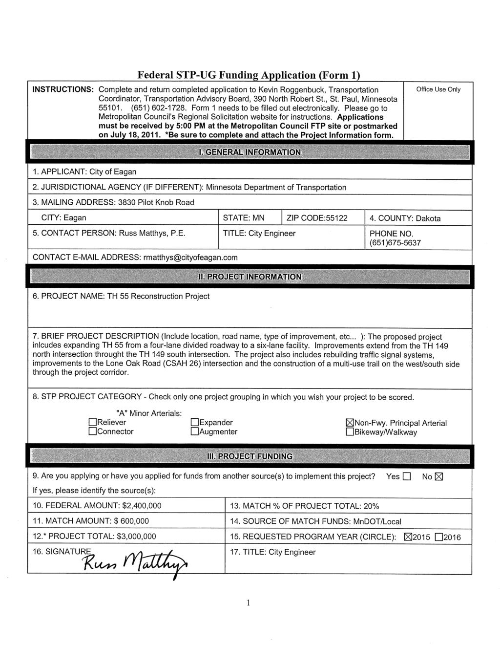
2 Federal STP Funding Application (Form 1) INSTRUCTIONS: Complete and return completed application to Kevin Roggenbuck, Transportation Coordinator, Transportation Advisory Board, 390 North Robert St., St. Paul, Minnesota (651) Form 1 needs to be filled out electronically. Please go to Metropolitan Council s website for instructions. Applications must be received by 5:00 PM or postmarked on June 15, *Be sure to complete and attach the Project Information form. (Form 2) Office Use Only I. GENERAL INFORMATION 1. APPLICANT: City of Eagan 2. JURISDICTIONAL AGENCY (IF DIFFERENT): Minnesota Department of Transportation 3. MAILING ADDRESS: 3830 Pilot Knob Road CITY: Eagan STATE: MN ZIP CODE: COUNTY: Dakota 5. CONTACT PERSON: Russ Matthys, P.E. TITLE: City Engineer PHONE NO. (651) CONTACT ADDRESS: rmatthys@cityofeagan.com 6. PROJECT NAME: TH 149 Reconstruction Project II. PROJECT INFORMATION 7. BRIEF PROJECT DESCRIPTION (Include location, road name, type of improvement, etc... A more complete description must be submitted separately as described in Specific Requirement #3 on p. 5): The proposed project includes expanding TH 149 from a four-lane divided roadway to a six-lane facility. Improvements extend from TH 55 to the I-494 north ramp intersection. The proposed project also constructs a multi-use trail on the west side of the corridor between TH 55 and the north I-494 ramp intersection. 8. STP PROJECT CATEGORY - Check only one project grouping in which you wish your project to be scored. "A" Minor Arterials: Reliever Expander Non-Fwy. Principal Arterial Connector Augmenter Bikeway/Walkway III. PROJECT FUNDING 9. Are you applying or have you applied for funds from another source(s) to implement this project? Yes No If yes, please identify the source(s): 10. FEDERAL AMOUNT: $2,480, MATCH % OF PROJECT TOTAL: 20% 11. MATCH AMOUNT: $620, SOURCE OF MATCH FUNDS: Local 12. PROJECT TOTAL: $3,100, REQUESTED PROGRAM YEAR (CIRCLE): SIGNATURE 17. TITLE: City Engineer
3 PROJECT INFORMATION (Form 2) (To be used to assign State Aid Project Number after project is selected) Please fill in the following information as it pertains to your proposed project. Items that do not apply to your project, please label N/A. Do not send this form to the State Aid Office. For project solicitation package only. COUNTY, CITY, OR LEAD AGENCY: City of Eagan COUNTY OR CITY NO.: 195 FUNCTIONAL CLASS OF ROAD: A Minor Arterial Reliever ROAD SYSTEM: TH (TH, CSAH, MSAS, CO. RD., TWP. RD., CITY STREET) ROAD NO.: 149 NAME OF ROAD: Dodd Road (Example; 1st ST., MAIN AVE) LOCATION: From: TH 55 To: 400 feet north of the northern interchange ramp of I-494 (DO NOT INCLUDE LEGAL DESCRIPTION) SECTION-TOWNSHIP-RANGE OF ONE END OF PROJECT: Section 2 Township 27N Range 23W TYPE OF WORK: Grade, Agg Base, Bit Base, Bit Surf, Curb and Gutter, Multiuse Trail, Storm Sewer, Signals, Ped Ramps (Examples: GRADE, AGG BASE, BIT BASE, BIT SURF, SIDEWALK, CURB AND GUTTER, STORM SEWER, SIGNALS, LIGHTING, GUARDRAIL, BIKE PATH, PED RAMPS, ETC.) BRIDGE/CULVERT PROJECTS OLD BRIDGE /CULVERT NO. NEW BRIDGE/CULVERT NO. STRUCTURE IS OVER NAME OF TWP.:
4 "A" MINOR ARTERIAL - RELIEVER - QUALIFYING CRITERIA The applicant must show that the project meets all the following criteria to qualify for priority evaluation. Answer each criterion in a numbered sequence. Failure to respond to any of the qualifying criteria will result in a recommendation to disqualify your project. 1. The project must be consistent with the policies in the Metropolitan Council's officially adopted Metropolitan Development Guide, which includes the Transportation Policy Plan (TPP) (2009) and the Regional Development Framework (2004). Consistency with the TPP includes its appendix, which contains the regional functional classification criteria. The applicant must list the documents and corresponding policy numbers or portions of text that help illustrate the project s consistency. The proposed project is located in a Developing Community (Regional Development Framework, page 22) and is consistent with Policy 1, Work Work with communities to accommodate growth in a flexible, connected and efficient manner. There are many areas that are continuing to develop within Eagan, particularly in the northeast portion of the city. The proposed project will support substantial future development in the northeast part of the city, located east and west of the TH 149 corridor. The proposed roadway improvements will also connect to other developing communities south and east of Eagan to major transportation facilities such as I-494, TH 55, and I-35E. The proposed project is located in a Developing Community (Regional Development Framework, page 22) and is consistent with Policy 2, Plan and invest in multi-modal transportation choices. The reliever route is a multiuse corridor accommodating vehicular, bike and transit modes. A multiuse trail is proposed along the west side of the project to provide improved pedestrian and bicycle facilities. Additionally, the improvements to the TH 149 corridor provide improved access to transit services in the area. The proposed project is located in a Developing Community (Regional Development Framework, page 22) and is consistent with Policy 3, Encourage expanded choices in housing location and types, and improved access to jobs and opportunities. The Cities of Eagan and Inver Grove Heights are working toward providing additional residential and commercial nodes within the TH 149 project area. Directly adjacent to the corridor, the City of Eagan has proposed developments including commercial and office uses. The City of Inver Grove Heights is proposing development in the northwestern portion of their city with various land uses, including low-, medium-, and high-density residential housing, commercial, office, and industrial uses. Improving mobility and safety along the TH 149 corridor will facilitate the connections between these employment centers within the Twin Cities (connections to I-494, TH 55 and I-35E are enhanced through this project). The proposed project is located in a Developing Community (Regional Development Framework, page 22) and is consistent with Policy 4, Work with local and regional partners to conserve, protect and enhance the region's vital natural resources. No impacts to inventoried local or regional natural resources are anticipated with this project. The proposed project is consistent with Policy 4 of the Transportation Policy Plan Strategy 4a (page 40), The Council will promote land use planning and development practices that maximize accessibility to jobs, housing and services. The TH 149 corridor is surrounded by land uses that provide jobs. The proposed improvements will provide enhanced access to these employment centers. 1
5 The proposed project is consistent with Policy 4 of the Transportation Policy Plan Strategy 4b (page 40), Transportation investments and land development will be coordinated to create an environment supportive of travel by modes other than the automobile including travel by transit, walking and bicycling. The proposed improvements to TH 149 include alternative travel modes. The proposed project will continue to support transit services along the corridor. Also, the proposed project includes the construction of a multiuse trail on the west side of the corridor. The proposed project is consistent with Policy 4 of the Transportation Policy Plan Strategy 4c (page 40), Transportation investments and land development along major transportation corridors will be coordinated to intensify job centers, increase transportation links between job centers and medium-to-high density residential developments and improve the jobs/housing connections. TH 149 is an arterial which connects a large number of commercial and job nodes and residential developments within the Cities of Eagan and Inver Grove Heights. Additional capacity improvements to TH 149 will allow for additional job concentrations to be developed in the northeast portion of Eagan and the northwest portion of Inver Grove Heights. The TH 149 corridor also connects to I- 494 and TH 55, which connect to other surrounding developing communities and the Twin Cities. Improvements to TH 149 will strengthen the connections between these employment and residential developments. The proposed project is consistent with Policy 4 of the Transportation Policy Plan Strategy 4f (Page 41), Local governments should plan for and implement a system of interconnected arterial and local streets, pathways and bikeways to meet local travel needs without using the regional highway system. These interconnections will reduce congestion, provide access to jobs, services and retail, and support transit. The City of Eagan is developing areas in the northeast part of the city, which includes land adjacent to the TH 149 corridor. Eagan is working with the City of Inver Grove Heights to create roadways that have sufficient capacity and connectivity to accommodate proposed development in both cities. The proposed local and collector roadway systems in the northeast part of Eagan and northwest part of Inver Grove Heights is being planned in a manner that provides appropriate transportation options on the appropriate local and regional systems. The proposed project is consistent with Policy 9 of the Transportation Policy Plan Strategy 9b (Page 60), The Council, Mn/DOT, local governments and transit providers will plan for and implement a multimodal roadway system. The proposed project continues to service existing transit that is currently on the TH 149 corridor. Additionally, the proposed project also includes a multiuse trail on the west side of the corridor. The proposed project is consistent with Policy 9 of the Transportation Policy Plan Strategy 9h (Page 62), Corridor Studies. The City of Eagan has completed the Grand Oak Business Park AUAR Update, the Northeast Eagan Areawide Traffic Study, and the Lone Oak Business Campus Traffic Study which examined proposed land use impacts to the existing roadway system. Impacts included access, capacity, level of service operations, and geometrics. The AUAR Update recommended improvements on TH 149 near the I-494/TH 149 interchange and the traffic studies recommended that this section of TH 149 be upgraded from a four to a six-lane roadway. The City of Eagan also has completed a Transportation Infrastructure Needs Analysis (TINA) that evaluates short- and long-term transportation needs within the city. The TINA lists this project (labeled M109 in the study) as a project that should be completed in the short-term. More recently, the Cities of Eagan and Inver Grove Heights as well as Dakota County completed the North-South Corridor Travel Demand Study to develop 2030 traffic forecasts and to consider a consolidated regional and county perspective broader than the local roadway system needs in the north-central portion 2
6 of Dakota County. The results of the travel demand study indicated significant needs on the regional roadway network. Most recently, the Minnesota Department of Transportation, Dakota County and the Cities of Eagan and Inver Grove Heights have partnered to complete a Regional Roadway System Visioning Study which will develop a vision for the area roadway system that addresses transportation issues in this area of Dakota County in a coordinated and balanced manner with area land use development plans. The visioning study is approximately 30% complete as of June 15, The proposed project is consistent with Policy 11 of the Transportation Policy Plan Strategy 11e (Page 64), State, county and local governments will manage access to the Metropolitan Highway System to optimize the performance of existing facilities. The proposed project maintains the existing access on an A minor arterial roadway, as implemented by Mn/DOT s access management guidelines. The proposed project does not add any new access points rather manages/maintains the current access on TH 149. The proposed project is consistent with Policy 18 of the Transportation Policy Plan Strategy 18d (Page 153), The Metropolitan Council, along with local and state agencies, will coordinate planning efforts to develop efficient and continuous bikeway systems and pedestrian paths, eliminate barriers and critical gaps and ensure adequate interjurisdictional connections and signage. The proposed project includes construction of a multiuse trail along the west side of the project. The trail will provide an interjurisdictional trail connection between the Cities of Eagan and Mendota Heights. This trail enhances the bicycle connection between the east side of Eagan and downtown St. Paul. The proposed project is consistent with Policy 18 of the Transportation Policy Plan Strategy 18e (Page 153), Local and state agencies will implement a multimodal roadway system and design and planning for principal or minor arterial road construction and reconstruction projects will explicitly consider off-road walkway and both on- and off-road bicycle accommodation with special emphasis placed on travel barrier removal and safety for bicyclists and pedestrians. The proposed project includes construction of a multiuse trail along the west side of the project. The trail can be used by both recreational and commuter traffic. As development occurs along the TH 149 corridor and south of TH 55, bicyclists and pedestrians can use the sidewalk to travel to these areas. The location of the trail on the west side of the corridor provides the least number of roadway crossings for users and completely avoids roadway crossings at the I-494 freeway ramp intersections. 2 The project must be included in, be part of, or relate to a problem, need or direction discussed in one of the following: 1) a local or county comprehensive plan found to be consistent with Metropolitan Council plans; 2) a locally approved capital improvement program; 3) an officially adopted corridor study reflected in the local plan; or 4) the official plan or program of the applicant agency. Because all communities in the seven-county Twin Cities region have recently completed or are currently in the process of updating their local comprehensive plans, applications in the 2009 solicitation may be for projects included in the most recent local comprehensive plan or the previous plan that was found to be consistent with Metropolitan Council plans. It also must not conflict with the goals and policies in these adopted regional plans; the 2030 Transportation Policy Plan (2009), the 2030 Regional Framework (2004), and the 2030 Regional Parks Policy Plan (2005/06). The applicant must reference the appropriate comprehensive plan, CIP, corridor study document, or other plan or program and provide copies of the applicable pages. The proposed project implements a solution to a transportation problem identified in the following documents: the City of Eagan s Comprehensive Plan (Updated May draft), Capital Improvement Plan (CIP), Grand Oak Business Park AUAR (September 1998), Grand 3
7 Oak Business Park AUAR Update (June 2004), Northeast Eagan Areawide Traffic Study (May 2005), Transportation Infrastructure Needs Analysis (May 2005), Lone Oak Business Campus Traffic Study (August 2006), and North-South Corridor Travel Demand Study (July 2007) (see Attachment B for all documentation). 3. The proposed project must be identified as on an A Minor Arterial Reliever shown on the TAB approved roadway functional classification map adopted by the TAB on or before April 15, 2009 and recorded in the Council s electronic file. The vast majority of the project must be physically located on the "A" Minor Arterial Expander roadway between logical termini. The project may include construction on small portions of non-eligible roads, as long as the construction is essential to the operation of the entire project. Examples include but are not limited to reconstruction of the approaches on intersecting collector roads and construction or reconstruction of on-ramps or offramps. The applicant must provide a map or sketch of the project relative to the A Minor Arterial Reliever system. The proposed project is identified as on an A Minor Arterial Reliever shown on the TAB approved roadway functional classification map adopted by the TAB in April 2009 and is recorded as such in the Council s electronic file. See Figure 3, Attachment A. 5. STP funds are available for roadway construction and reconstruction on new alignments or within existing right-of-way, including associated construction or installation of traffic signals, signs, utilities, bikeway or walkway components and public transit components. The cost of constructing a new bridge deck or reconstructing an existing bridge deck is eligible but the remainder of the superstructure and all elements of the substructure are not eligible. The applicant must describe the proposed project and state that the application includes only the eligible components. The TH 149 (Dodd Road) project area is 0.87 miles in length (4594 feet) with a southern terminus of TH 55 and a northern terminus of 400 feet north of the northern interchange ramp of I- 494, City of Eagan, Dakota County. The proposed improvements are summarized as follows and in Figure 4, Attachment A: The road will be widened to accommodate an additional lane of motor vehicle travel in either direction. Each added lane will be 12 feet wide. Throughout the majority of the improvement, the widening can be accomplished within existing Mn/DOT Right of way. Two small areas will require acquisition of an additional amount of right of way; specifically, along the east side of TH 149 from the north side of Lone Oak Parkway to 400 feet north of the north side of Lone Oak Parkway and in the northeast quadrant of the intersection of TH 149 and O Neill Road. A multi-use trail will be constructed along the entire west side of the project area. This trail will be 10 feet wide with 2 feet of clear zone on either side. The trail will have a bituminous surface. A bituminous trail surface was selected because it is more cost effective than other treatments, offers a wide variety of trail uses attracting more users, and is consistent with the proposed adjoining trail segment currently under consideration along the south side of TH 55. The proposed multi-use trail will include crossings of West Blue Gentian Road and Grand Oak Circle North. Medians, separating turning traffic from through traffic, will be constructed at each intersection on the east side of TH 149. These medians will not be constructed at intersections on the west side of TH 149. In addition, medians separating north from southbound traffic, in the vicinity of the I-494 interchange, will be narrowed to accommodate the additional travel lanes and the multi-use trail. Signals will be improved at the intersection of TH 149 (Dodd Road) with (south to north) TH 55, Lone Oak Parkway, Northwest Parkway, the south interchange ramp of I-494, and the north interchange ramp of I
8 Shoulders will be widened to 12 feet along most of the east and west sides of TH 149 within the project area. This application includes only the eligible components. 6. Studies, preliminary engineering, design, construction engineering, etc. are not eligible for STP funding and should not be included in the required local match or the total project cost. Right-of-way costs are not eligible for STP funding and should not be included in the required non-federal match or the total project cost. Noise barriers, drainage projects, fences, landscaping, etc., are not eligible for STP funding as stand-alone projects, but are eligible if included as part of a larger, eligible project. The applicant must state that pre-construction work and ROW costs are not part of the total project cost in this application. Preconstruction work and right-of-way costs are not part of the total project cost stated in this application. 7. An STP construction or reconstruction project must be a permanent improvement. Traffic management projects as part of a construction project are exempt from this policy. Temporary construction is defined as work that must be essentially replaced in the immediate future (within 5 years). Staged construction is considered permanent rather than temporary so long as future stages add to, rather than replace, previous work. The applicant must state that the proposed project is a permanent improvement and does not replace any regionally funded project that was opened to traffic within five years. The proposed project is a permanent improvement and does not replace any regionally funded project that was opened to traffic within five years. 8. Applicants can request up to a cap of $7,000,000 in STP funds for a specific A Minor Arterial Reliever project. Other federal funds may be combined with the requested STP funds, but the source(s) must be identified in the application. The cost of preparing a project for funding authorization can be substantial. For that reason, the project's federal cost must exceed $1,000,000. The applicant must show the requested federal amount and total project cost on the cover page. The total project cost is $3,100,000. The City of Eagan is requesting $2,480,000 in Surface Transportation Program funds (80 percent of the total project cost). This amount exceeds the $1,000,000 federal cost minimum. 9. STP funds awarded in the regional solicitation must be matched with non-federal funds. The nonfederal match for any STP project must be at least 20% of the total cost. The applicant must state that it is responsible for the local (nonfederal) share. If the applicant expects any other agency to provide all or part of the local match, the applicant must include a letter or resolution from the other agency agreeing to participate financially in the project s construction. The City of Eagan will provide the remaining 20 percent local match. Mn/DOT supports the project but cannot make a financial commitment at this time (see Attachment D for letters of support). In addition, Eagan s City Council has officially passed a resolution supporting the TH 149 Reconstruction project (see Attachment B). Although not providing financial support for the project, Dakota County strongly supports the proposed project (see Attachment D). 10. The applicant must include a letter from the agency with jurisdiction over the road indicating that it is aware of and understands the project being submitted, and that it commits to operate and maintain the 5
9 facility for its design life and not change the use of any right-of-way acquired without prior approval from MN/DOT and the Federal Highway Administration. The agency with jurisdiction over TH 149 is the Minnesota Department of Transportation (Mn/DOT). As part of said jurisdiction, Mn/DOT will operate and maintain the facility throughout its design life. 6
10 A MINOR ARTERIAL - RELIEVER - PRIORITIZING CRITERIA Applicants must respond to each of the following prioritizing criteria. Label your responses clearly. If a criterion is not applicable to your project, explain why. A. Relative importance of the route as an A Minor Arterial Reliever. 100 points Although all Reliever routes parallel an urban principal arterial, the relative importance of each Reliever is not the same. Some Relievers play a more significant role than others do in providing an alternative route for medium distance trips and reducing demand on congested metro area principal arterials. The following criteria are intended to measure the relative importance of each Reliever route submitted for funding in this solicitation. Definition and characteristics of the Reliever route points The applicant must respond to all three items below and provide a map to help answer items a) and b). The Reliever route is defined as the uninterrupted length of the arterial that parallels a principal arterial. The route may be an existing or planned road on the TAB adopted system. The route may be longer than the proposed project and include more than one street name, but it must be continuous. The endpoints of the route must be a principal or other A minor arterial, and the route cannot be more than eight miles in length. Two projects on the same route will not be selected unless they are at least 3.5 miles apart. Points under this criterion are assigned based on the length of the Reliever route, the current and forecasted traffic volume on the Reliever route and the current transit ridership on the Reliever route. For Items a, b and c, please reference Attachment A, Figure 4. a) Provide the length of the Reliever route in miles. The length of the reliever route (TH 149) in approximately 3.5 miles from TH 55 (in the City of Eagan) to TH 110 (in the City of Mendota Heights). b) Provide the current (2007) and forecasted (2030) average daily traffic volume at two or more locations on the Reliever route. MN/DOT 50-series maps should be used for current counts. Use approved city or county comprehensive plans, Met Council, accepted State Aid traffic factors by county, or a transportation study with documented acceptable forecasting methodology for forecasted volume. According to Mn/DOT s MSAS Traffic Volume maps, the current (2006) Average Annual Daily Traffic (AADT) on TH 149 between TH 55 and I-494 is 23,500 vehicles per day. North of I-494, traffic volumes are 8,100 vehicles per day. As part of the City s draft 2009 update to the Comprehensive Plan, traffic forecasts were developed for 2030 (see Attachment B). The 2030 forecast volume for TH 149 from TH 55 to Northwest Parkway is 32,000 vehicles per day. The 2030 forecast volume for TH 149 from Northwest Parkway to I- 494 is 42,000 vehicles per day. 7
11 c) Is public transit currently provided on this Reliever route and its corresponding section of Principal Arterial? If yes, the Metropolitan Council will provide the project scorers with current average annual ridership based on the project location map and description. Transit service utilizes TH 149 for access to service points within the Grand Oak Business Park and the Water s Corporate Complex on both sides of TH 149, but does not offer stops along the project corridor. Similarly, transit providers utilize the corresponding sections of Principal Arterial (TH 55 from TH 149 to I-494 and I-35E from TH 55 to I-494) for access to service point while not offering stops along the Principal Arterial corridor in these segments. B. Deficiencies and Solutions on Reliever and on Principal Arterial Being Relieved 350 points The regional solicitation process is one means of implementing regional plans. The region's Transportation Policy Plan state that the regional highway and street system will be preserved, managed, improved and expanded to support existing and planned land uses and safety and mobility needs consistent with the Regional Development Framework, the Transportation Policy Plan and approved local and county comprehensive plans. The following criteria reflect these objectives. 1. Crash Reduction points On the Principal Arterial being relieved: Provide data showing the frequency of traffic crashes expressed as crashes per million vehicle miles on the corresponding section of principal arterial. The principal arterial being relieved should be approximately the same length as the project limits on the reliever. Only one principal arterial may be relieved. The applicant must request from Mn/DOT Metro Traffic Engineering, the crash rate for the principal arterial being relieved. The rate received from Mn/DOT will include mainline crashes only. Crash rates will be based on TIS data for Using Mn/DOT s TIS system data, the corresponding section of TH-55 between TH 149 and I-494 had a total of 38 crashes from January 1, 2005 through December 31, The crash rate for the principal arterial was 1.57 crashes per million vehicle miles per year (see Attachment E, Principal Arterial Crash Analysis) points On the Reliever: Calculate the total number of crashes reduced due to improvements on the A Minor Arterial Reliever made by the proposed project. Points will be awarded based on the total three-year number of crashes projected to be reduced by the proposed project. The applicant must base the estimate of crash reduction on the methodology found in Appendix E. The applicant must obtain data on crashes for the existing section scheduled for improvement from Mn/DOT s TIS system, and must use data from 2005 through As previously indicated, the proposed improvements to TH 149 are intended to increase safety on the corridor. According to Mn/DOT s TIS system data from January 1, 2005 to December 31, 2007, there are a total of 57 crashes Applicants should request crash data from Mn/DOT as early as possible. An agency that wishes to dispute the results of their crash data requests can contact Jolene Servatius at (or jolene.servatius@dot.state.mn.us) to reconcile those differences. 8
12 on TH 149 within the project area (see Attachment E, crash diagrams and TIS data listing). This includes 14 personal injury crashes and 43 property damage only crashes. According to the Mn/DOT factors shown in the calculations below, the proposed project would eliminate 33.3 crashes. This is a 58 percent reduction in the number of crashes on the corridor. Crash calculations are shown below. Improvements from Mn/DOT s % Change in Crashes table: Add Lanes reduction in fatal and injury crashes reduction in property damage crashes T-Intersection Turn Lane reduction in fatal and injury crashes reduction in property damage crashes Fatal and Personal Injury Calculations CR = 1- (1-0.5) x (1-0.20) CR = 1 (0.5 x 0.80) CR = x 14 (Number of fatal and injury crashes) = 8.4 reduction Property Damage Calculations CR = 1-(1-0.5) x (1-0.15) CR = 1-(0.5 x 0.85) CR = x 43 (Number of fatal and injury crashes) = 24.9 reduction Total Crash Reduction = 33.3 crashes reduced 2. Air Quality. The Transportation Policy Plan strongly supports environmental considerations when making transportation funding decisions. The Council supports funding priorities for transportation projects that ensure prevention of air quality violations through the reduction of mobile source emissions. The applicant must show that the project will reduce emissions and help the region to maintain its attainment of federal carbon monoxide standards. All assumptions and calculations must be clearly documented and explained in order to receive points. The applicant must include documentation of how the VMT reduction was determined and specify the speed used for the assumptions. Speed assumptions shall be based on the methodology found in Appendix F. Points under this criterion will be awarded based on the reduction of carbon monoxide (CO), nitrogen oxide (NOx), and/or volatile organic compounds (VOC) emissions the proposed project is expected to provide points The applicant must demonstrate through a quantitative analysis that CO, NOx, and/or VOC emissions (in KILOGRAMS/DAY) will be reduced compared to the no-build alternative. The applicant must estimate CO, NOx, and/or VOC emissions reductions using the MOBILE6 emissions factors and vehicle emissions reduction worksheet in Appendix G. 9
13 In order to determine the reduction of emissions, an analysis to determine the increase in peak hour speed on TH 149 (Northbound direction during the p.m. peak hour) due to the proposed project was conducted. Details of the analysis are shown below: Estimated Segment Length = 0.90 mile Posted speed limit = 45 mph Existing Conditions 4 signalized intersections (2 v/c <0.8 and 2 v/c >0.90) Free-flow travel time (minutes) = (0.9 mile/45 mph) x 60 = 1.2 minutes Intersection delay = (2 x 75) + (2 x 30) = 210 seconds = 3.5 minutes Mid-block delay for right turn movement to eastbound I-494 ramp= 10 seconds = 0.17 minutes Arterial Speed = (0.9 mile/( minutes)) x 60 = 11 mph Proposed Conditions 4 signalized intersections (3 v/c <0.8 and 1 v/c 0.8 to 0.90) Free-flow travel time (minutes) = (0.9 miles/45 mph) x 60 = 1.2 minutes Intersection delay = 50 + (3 x 30) = 140 seconds = 2.33 minutes Mid-block delay = 0 Arterial Speed = (0.9 mile/( minutes)) x 60 = 15 mph Using the MOBILE6 emissions factors and vehicle emissions reduction worksheet (see Attachment E, Vehicle Emissions Reduction Worksheet), a quantitative analysis was conducted for emissions for both baseline (without project) and build (with project) conditions. The average speed along TH 149 is expected to increase by 3 mph, due to the proposed improvements. The emissions reduction due to the proposed improvements is 135 kilograms/day. 3. Congestion Reduction points On the Principal Arterial being relieved: The applicant needs to show the hours per day the current volume exceeds the design capacity in either direction. The applicant should obtain needed data directly from Mn/DOT or a local data source if available, and provide documentation to illustrate accuracy. To calculate existing conditions, the applicant must obtain or collect the average hourly, directional traffic volumes on a weekday, the current lane configurations, and the current signal timing schemes, if applicable. Design capacity calculations must be based on the definition found in Appendix A. As identified by reports from Mn/DOT, current traffic volumes are within the design capacity guidelines of I-35E (six-lane freeway) between TH 55 and I points On the Reliever: The applicant must show that the proposed project will reduce congestion at the most congested location on the Reliever. The applicant must include the current volume to capacity (v/c) ratios in the AM and PM peak hours and the improvement in the ratios resulting from the project. Projects that have low existing v/c ratios will receive less credit for the improvement resulting from the project than projects that address a problematic existing v/c ratio. The applicant must use the methodology, worksheet and look-up tables found in 10
14 Appendix H. The applicant must conduct a corridor analysis for new alignments, comparing parallel routes that will be affected by the project. The intersection of TH 149 and the I-494 South Ramps is currently the most congested location in both the a.m. and p.m. peak hours along the project segment. Details of the volume to capacity ratio (v/c) analysis are shown below: Existing conditions Southbound a.m. peak hour volume = 689 Vehicle capacity = 1500 vph (one left-turn lane, two through lanes) A.M. volume/capacity ratio = 689/1500 = 0.46 Northbound p.m. peak hour volume = 1480 Vehicle capacity = 1400 vph (two through lanes, one right-turn lane) P.M. volume/capacity ratio = 1480/1400 = 1.06 Proposed Conditions Southbound a.m. peak hour volume = 689 Vehicle capacity = 2100 vph (one left-turn lane, three through lanes) A.M. volume/capacity ratio = 689/2100 = 0.33 Northbound p.m. peak hour volume = 1480 Vehicle capacity = 2000 vph (three through lanes, one right-turn lane) P.M. volume/capacity ratio = 1480/2000 = 0.74 A.M. Improvement in Volume/Capacity Ratio = = 0.13 P.M. Improvement in Volume/Capacity Ratio = = 0.32 Total Improvement in Volume/Capacity Ratio = 0.45 C. Cost Effectiveness. 275 points The Regional Development Framework and Transportation Policy Plan document the need for adequate transportation funding to implement regional transportation plans. The region must allocate transportation funds in such a way that the selected projects provide the most benefit for the amount of funding requested. Cost effectiveness is an essential component of the regional solicitation process. Cost effectiveness calculations must be based on the total cost of the project, not just the portion of the project eligible for federal funding, in order to allow consistent comparisons of all qualifying projects. 1. Crash Reduction points The applicant must calculate the cost per crash reduced by the proposed project. The applicant must divide the total cost of the project by the answer from the second part of criterion B.1., crash reduction on the Reliever. The applicant must obtain data on crashes for the existing section scheduled for improvement from MN/DOT's TIS system, and must only use data from 2005 through The applicant must base the estimate of crash reduction on the methodology found in Appendix E. Points will be awarded based on the relative cost per crash reduced. 11
15 The proposed improvements will be expected to eliminate 33 crashes per year. The total project cost is $3,100,000. The cost per crash reduced by the proposed project is $93, Congestion reduction points The applicant must calculate the cost per increase in hourly person throughput provided by the proposed improvement. The applicant must use the worksheet in Appendix I. Points will be awarded based on the lowest cost per increase in person throughput, but if there is little congestion under existing conditions fewer points will be awarded for increasing person throughput. The hourly throughput in the p.m. peak hour, in the peak direction of travel (northbound), at the most congested location (TH 149/I-494 north ramps) was calculated for current and proposed conditions. Details of the analysis are shown below: Existing Conditions Vehicle capacity = 1400 vph (two through lanes, one right-turn lane) A.M. peak hour vehicle occupancy = 1.09 A.M. peak hour bus ridership = 0, assume no increase in service Hourly person throughput = 1400 x 1.09 = 1526 pph Proposed Conditions Vehicle capacity = 2000 vph (three through lanes, one right-turn lane) A.M. peak hour vehicle occupancy = 1.09 A.M. peak hour bus ridership = 0, assume no increase in service Hourly person throughput = 2000 x 1.09 = 2180 pph Total Increase in Hourly Person Throughput = = 654 Cost per Increase in Hourly Person Throughput = $3,100,000/654 = $4, Air Quality 0-75 points The applicant must calculate the cost per kilogram that will be reduced by the proposed project compared to the no-build alternative. The applicant must use the estimated CO, NOx, and/or VOC emissions reductions calculated in questions B.3. and divide it into the total project cost. The proposed improvements will be expected to reduce total emissions by 135 kilograms per day. The total project cost is $3,100,000. The cost per kilogram reduced by the proposed project is $22,937. D. Development Framework Implementation. 425 points The 2030 Development Framework is the initial chapter and unifying theme of the Council s metropolitan development guide. Together with the Council s regional policy plans, the Framework is intended to help ensure the orderly, economical development of the seven-county area and the efficient use of four regional systems: transportation, aviation, water resources (including wastewater collection and treatment) and regional parks and open space. The Framework was adopted in January 2004, and amended in December The Council s strategies are organized around four policies: 12
16 Accommodating growth in a flexible, connected and efficient manner. Slowing the growth in traffic congestion and improving mobility. Encouraging expanded choices in housing locations and types. Conserving, protecting and enhancing the region s vital natural resources. Under the Metropolitan Land Planning Act, local communities must prepare and submit to the Council local comprehensive plans that are consistent with the Council's regional system plans. The new or updated local comp plans were due by the end Plans submitted for Council review after that date but not yet approved by the Council may be used for the purposes of answering these criteria. 1. Development Framework Planning Area Objectives 0-75 points Higher scores will be attributed to projects that demonstrate that the project supports Framework Planning Area policy directions and strategies and forecasts reflected in local comprehensive plans (2008 update approved by Council or a plan update that is complete for review). Higher scores will also be given for projects that support more intense, mixed-use development (residential, commercial, industrial) in centers along transportation corridors. Applicant provides: a) Project Area Location (The project area comprises the TAZs in which the project is located. Provide a map and identify TAZs in which the project is physically located); The project area forms the border between 2000 Met Council TAZs 258 and 259 with Zone 258 being west of TH 149 and Zone 259 east of TH 149 (see Figure 5, Attachment A). b) Identify what the Framework Planning Designation for the Project Area and how the project supports Framework strategies for the planning area (see Framework chapter 3 Strategies for Geographic Planning Areas including the relationship of the project to community development plans and objectives e.g. intensification of centers, mixed use development, development staging, and/or redevelopment/infill plans. The TH 149 corridor presently serves an important role in the regional roadway network as an A minor arterial route relieving traffic on I-35E and TH 55. Currently, the majority of land uses directly adjacent to and near TH 149 include mainly industrial and office developments. As mentioned in the Grand Oak Business Park AUAR Update, Northeast Eagan Areawide Traffic Study and Lone Oak Business Campus Traffic Study, substantial future development is expected in the northeast part of the city. These areas of development will rely on the TH 149 corridor for local and regional access. Future land use includes additional office and commercial developments. The TH 149 corridor will also continue to play a vital role in serving north-south traffic in the City of Eagan. The proposed improvements will provide safer operations for the traffic accessing the office and retail nodes, as well as the I-494 and TH 55 regional transportation systems. North of I-494 between TH 149 and CR 63, future plans include the redevelopment of single-family residential housing units to multi-family residential in the City of Mendota heights. By improving the operations at the TH 149/I-494 interchange, the proposed project will help the corridor serve the more intense land uses planned along and near the corridor. 13
17 Land use intensification is born out of traffic analysis zones (TAZs) located adjacent to and near the project corridor. The table below shows the household and employment data for 2006/2007 and 2030 TAZs adjacent to the TH 149 corridor in Eagan. (It should be noted that the City of Eagan s employment forecasts for 2030 exceed the Met Council system statement. The City and Met Council are in the process of reconciling the Citywide employment numbers.) TAZ # 2007 HH 2030 HH Number Increase 2006 Employ 2030 Employ Number Increase ,546 4,746 1, ,584 13,746 9,162 Total Corridor ,130 18,492 10,362 Zone 258 is adjacent to the TH 149 (west) and Zone 259 is adjacent to TH 149 (east). Planned growth along the TH 149 route results in 1 additional households. Contrastingly, employment growth increases by 10,362 by the year Zone 259 shows the greatest amount of employment growth (increase of 9,162), which corresponds to the increase in land use to fully developed with retail, office, and commercial areas. The City s Comprehensive Plan shows many areas adjacent to the corridor as either being vacant or underutilized. The areas east and west of TH 149 show that some of the area is vacant and the land use maps indicate these areas will be mostly office and retail development. The proposed roadway improvements will be able to support the land use intensification as these areas fully develop. The City of Eagan has completed three studies related to the project area: 1) Northeast Eagan Areawide Traffic Study; 2) Transportation Infrastructure Needs Analysis (TINA); and 3) Lone Oak Business Campus Traffic Study. The Northeast Eagan Areawide Study examined the traffic impacts on roadways of development directly adjacent to the corridor. According to the Northeast Eagan Areawide Study, which incorporates some development in the Grand Oak Business Park, the proposed developments are anticipated to generate a significant amount of traffic (about 74,000 additional daily trips) with the office/clinics and retail land uses. Because the proposed development is anticipated to generate a large amount of traffic, the study recommends that TH 149 be a six-lane facility (see Attachment B). The City of Eagan has also completed a Transportation Infrastructure Needs Analysis (TINA), which looks at the City s future transportation needs. The TINA helps the City determine future transportation projects based on traffic studies, and city, county, and state transportation improvement plans. The TINA includes this project as one of the City s short-term projects to provide the increase in capacity to meet the needs of additional growth along the corridor over the next 20 years. The proposed project will support and anticipate the intensification of these developments. Finally, the Lone Oak Business Campus Traffic Study examined the impact of an 85 acre office/warehouse development located approximately 0.8 miles east of TH 149. The proposed development utilizes TH 149 for access to the regional transportation network. The results of the study found that TH 149 will need to be expanded to a six-lane facility (three lanes in each direction) from TH 55 to the I-494 north ramp to accommodate additional regional traffic. 14
18 The City of Inver Grove Heights has completed an Alternative Urban Areawide Review (AUAR) that discusses land use changes in the northwest portion of the city, which is adjacent to proposed development in the northeast portion of Eagan (see Attachment B, Inver Grove Heights AUAR). Proposed land uses in Inver Grove Heights include low-density, medium-density, and highdensity residential, office, industrial, and commercial developments. This development is expected to generate over 90,000 trips per day, some of which will use TH 149 between TH 55 and I-494. The proposed development in Inver Grove Heights will impact TH 149 with additional traffic along the project corridor. These developments, both in Eagan and Inver Grove Heights, will rely heavily on the TH 149 corridor for local and regional access. The proposed project will provide a stronger local link between the Cities of Eagan and Inver Grove Heights and stronger regional link to other surrounding areas and help support the intensification of the proposed developments. 2. Natural Resources c) Council staff will provide the following information to assist in the evaluation of this criterion: TAZ Project Area demographic profile: Population: 2000, 2010, 2020, 2030 Households: 2000, 2010, 2020, 2030 Employment: 2000, 2010, 2020, 2030 Retail Employment: 2000, 2010, 2020, 2030 TAZ Project Area land use profile: o Acreage by existing land use category o Planned land use (summarized from local comprehensive plans) 0-45 points A project will score higher if sensitive natural resources are avoided and if best management practices are employed in project implementation beyond which is minimally required by law. Describe in a brief narrative how the project relates to identified regional natural resource areas and any local community natural resource inventory and reference attached map(s). If the project has potential for assisting restoration or has a potential adverse impact, describe the resource, impact and what implementation practices will be employed. For identified natural resource areas go to ( The proposed project will not impact any identified natural resource areas. When the proposed project is designed, all efforts will be taken to ensure that there are no or minimal impacts to natural resources in the project area. Best management practices with regard to construction will be employed to reduce impacts from runoff and other issues that occur during construction. Also, new construction can provide better mitigation than older roadways for runoff and other drainage issues. Therefore, when TH 149 is upgraded to a six-lane facility, drainage and roadway runoff can be minimized or even prevented, which would result in a better quality natural area. The proposed project will increase the capacity and through mobility along the TH 149 corridor, providing better connections to civic centers in the area. Civic centers in the area include schools and parks. For example, Trinity Lutheran Church, a private school, is located near the intersection of TH 149 and TH 55, which is also a historic site. The roadway connects to many parks and lakes north of the project corridor. The proposed project will improve the operations at the TH 149/I-494 interchange, which is an important 15
19 connection to the parks and civic areas north of the project corridor. Adjacent to TH 149 is the Mendakota Park, a 19-acre community park that has many amenities including softball fields, basketball and volleyball courts, a picnic shelter and paved walking paths within the park. Just north of the Mendakota Park is the Mendakota Golf Course. The Friendly Marsh Park, located near the project corridor, is a natural area that attracts a variety of wildlife and is adjacent to the Dodge Nature Center. The Dodge Nature Center is over 300 acres and offers a variety of activities and natural areas. Activities range from school programs to hiking to tours. Natural areas include prairies, marsh lands, ponds, orchards, and woodlands. The Dodge Nature Center also offers classroom spaces to teach children about various topics and has other buildings that house many animals. In addition, the Saint Thomas Academy is located just west of TH 149 in Mendota Heights, along Mendota Heights Road. The Academy is a Catholic, all-male, college-preparatory military school for grades 7 through 12. East of the Saint Thomas Academy is the Visitation School, which is a Catholic School for boys and girls in Montessori preschool through sixth grade and a college preparatory school for young women in grades seven through twelve. Both schools are for students in the Twin Cities area. 3. Progress Towards Affordable Housing Goals NOTE: Information and analysis in this section will be provided by Council staff points Up to 30 points can be awarded to a project, based upon a community s or group of communities progress in addressing their affordable housing goals for Example of Analysis: For communities that participate in the Livable Communities Local Housing Incentives Program, data from their negotiated housing goals will be used to determine the progress they have made toward providing opportunities to their address affordable housing goals. For communities that do not participate in the Local Housing Incentives Program, progress will be measured against what the benchmarks were for their community in the Council s LCA goal setting methodology used in determining goals for 1996 to Benchmark or Progress Made to Benchmark or Progress Made to Average Ownership Goal Date Rental Goal Date Progress Made 900 units 200 units (22%) 200 units 125 units (63%) 43% Percent of Progress Made: Points Awarded: % % % % % % 5 4. Land Use and Access Management Planning 16
20 The Development Framework includes support for connected land use patterns served by an integrated street network. Access management along highways is a key component of planning for these objectives. In addition, various access management strategies can reduce crashes, improve traffic flow, and add operational capacity for the applicable roadway. Higher scores will be given to projects that are developed using a local access management plan and to projects located in communities that have a regulatory framework established to protect and improve access control in the future. Additional points will be awarded to projects that implement these plans by reducing undesired access points points Reference and describe the local access management plan used to develop the proposed project, and describe the corresponding county or state access management plan which supports the regional road network. Higher scores will be awarded to projects developed with an approach that is consistent with county or state access management plans. TH 149 is a state highway and is under the Minnesota Department of Transportation s jurisdiction. The plan uses access management guidelines developed by Mn/DOT (see Attachment C). According to Mn/DOT s guidelines, TH 149 is a Category 5B, which is a minor arterial in an urban/urbanizing area. Mn/DOT s access guidelines are the focus for the corridor s access management plan. The recommended spacing for A minor arterials in urbanizing areas is shown in Attachment A, Figure 6. In general, full-access signalized intersections may be placed at quarter-mile (1,320 feet) spacing and secondary access or right-in/right-out access can be spaced an eighth of a mile (660 feet) apart. Private driveway access is subject to exceptions and deviations. Existing and proposed access along TH 149 in the project area shown in Attachment A, Figure 7, is consistent with Mn/DOT access management guidelines. No additional access is anticipated in the future. Provide and identify intersection spacing and signal spacing guidelines, and driveway allowance criteria used for the proposed project and the corresponding county or state access management guidelines. Mn/DOT s access guidelines are the focus for the corridor s access management plan. In general, full-access signalized intersections may be placed at quarter-mile (1,320 feet) spacing and secondary access or right-in/right-out access can be spaced an eighth of a mile (660 feet) apart. Private driveway access is subject to exceptions and deviations. 5. Land Use and Access Management Planning 0-50 points Having the necessary regulatory framework is essential for protecting the efficient functioning of the regional roadway network. Reference (adoption date) and describe the local zoning and subdivision ordinance regulations that are in place to maintain the access plan as adjacent properties are developed and/or redeveloped. Higher scores will be awarded to projects in communities with existing or proposed local support of the access management plan through existing regulations or ordinances. The City of Eagan adopted Mn/DOT s access spacing guidelines via the Transportation Section of its Comprehensive Plan. The City Council approved the 2008 update to the Comprehensive Plan on May 19,
21 6. Corridor Access Management Improvements 0-50 points Projects that help to implement the access management plan by removing or modifying non-conforming access points will receive points in this criterion. Identify the access locations and access management that currently exists and that will be allowed once the project is completed. Indicate by the following classifications, the existing access locations inconsistent with the proposed access management approach and any access locations that will be modified: The existing access points are in conformance with Mn/DOT s access management guidelines. Upon completion of the project, Mn/DOT s access management guidelines will continue to be implemented along the project corridor. a. Private Residential Driveways/Field Entrances The TH 149 project corridor does not contain any existing non-conforming private residential driveways or field entrances. b. Low-Volume Private Driveways * (Under 500 trips per day) The TH 149 project corridor does not contain any existing low-volume private driveways. c. High-Volume Private Driveways * (Over 500 trips per day) The TH 149 project corridor does not contain any existing high-volume private driveways. d. Public Streets The current intersection spacing for public streets is in conformance with Mn/DOT s access guidelines. * Private driveways may be commercial, industrial or institutional uses such as school or hospitals. 7. Integration of Modes points The Transportation Policy Plan places importance on investing in multimodal transportation choices and supports the development of a transportation system that accommodates the mobility needs of users of all modes including motorists, transit vehicles and riders, pedestrians of all levels of functional ability, bicyclists and freight movers. A Minor Relievers are located parallel to congested principal arterials in the core, urban reserve and urban staging areas. Many of these roadways are served by transit and accommodate travel to congested activity centers and others provide important medium length routes parallel to principal arterials that may be inaccessible to non-motorized travelers. A Minor Relievers also play an important role in the movement of freight because they add capacity to freight origins and destinations. Please provide the information requested below on the existing conditions and proposed changes to the roadway environment and include maps, schematics or cross-sections as appropriate. Please note that all projects that receive STP funding must meet the requirements of the Americans with Disabilities Act (ADA). If the project does not include any multimodal components or does not impact one or more modes of travel, it is only necessary to answer questions related to the existing 18
22 conditions for each mode. Evaluation of this criterion will be based on the degree to which multimodal transportation objectives are incorporated into the project. The appropriate extent and character of multimodal improvements may differ based on the role that the road serves and differing roadway conditions that can affect its design. Transit: Roadway projects can support transit service by improving accessibility to transit stops by pedestrians, installing bus stop amenities for passengers, placing bus stops on the far side of intersections and improving the pedestrian environment, particularly for people with disabilities. In some cases, other improvements to the roadway including curb bump-outs for bus stops or the construction of bus lanes can improve transit service reliability and speed along the segment. Projects will not be evaluated based on the existence of transit service but rather how the needs of transit vehicles and passengers are incorporated into the project if transit service exists. Existing Conditions: Is there transit service and/or stops along the segment of the project? Transit service utilizes TH 149 for access service points within the Grand Oak Business Campus and the Water s Corporate Complex, but does not offer stops along the project corridor. If so, provide a map that shows the current placement of bus stops along the segment. If not, the project will be evaluated solely on the non-motorized and freight components of this criterion. Describe transit stop compliance with current ADA Accessibility Guidelines if applicable (curb ramps, boarding and alighting areas and accessible connections to sidewalks and streets). Not applicable Changes to Conditions from the Project: How will the project affect transit service or the conditions for transit riders along the project segment? Not applicable Pedestrians: Roadway projects can be opportunities to improve the environment for pedestrian activity that occurs or may occur in the project area. Improvements to the pedestrian environment include the construction or reconstruction of walkways or multi-use paths, separating pedestrian walkways from vehicle traffic through the installation of a buffer such as a boulevard and providing lighting. Equally important to improving pedestrian movement along the project area is improving the safety and ease of pedestrian crossings of the roadway. Some examples of these kinds of improvements are installation of pedestrian countdown signals, marking crosswalks, reducing the effective crossing distance for pedestrians by installing curb extensions and pedestrian medians, and by influencing the speed of vehicles making turning movements at intersections. Different treatments are appropriate for different types of roadway conditions. Provide information on the existing conditions for pedestrians in the project area: 19
23 Provide a map or aerial photo/schematic that shows all existing pedestrian walkways, multi-use paths and signalized and unsignalized pedestrian crossings in the project area. See Figures 8-10, Attachment A for details on existing pedestrian facilities. Describe or show on a map how the walkways or multi-use paths are connected to a wider pedestrian network beyond the project area. Describe destinations in the network such as schools, residential areas, transit stops, etc. within a half-mile of the project area: The existing pedestrian facilities within 0.5 miles of the project area consist of an off-roadway trail systems located in the Grand Oak business campus (west side of TH 149, between TH 55 and I-494), in The Waters Corporate Complex (east side of TH 149, between TH 55 and I- 494) and along Mendota Heights Road in the City of Mendota Heights. No pedestrian facilities currently exist along the proposed project corridor. Briefly describe the pedestrian environment along the walkways in the project area including landscaping, roadway/walkway buffers, lighting, etc.. If markedly different conditions exist along different parts of the roadway segment, describe them separately paying particular attention to existing deficiencies that will be addressed by the project. If a there are bridges along the project section, describe the pedestrian condition on and approaching the bridge. No pedestrian facilities currently exist along the proposed project corridor. Provide information on changes to the pedestrian environment from the project and provide a plan or schematic if one has been developed: See Figure 4, Attachment A for details on the proposed multiuse trail. Describe methods that will be used to facilitate safer and more pleasant pedestrian movement alongside the roadway The proposed project includes the construction of a 10-foot wide multiuse, bituminous trail separated from the TH 149 shoulder by a grass boulevard. The trail will have 2-foot wide shoulders and will be designed to a 20-mph design speed. The trail is proposed to be constructed on the west side of TH 149 to reduce the number of roadway crossings and eliminate bicycle/vehicle interactions at the I-494 north and south ramps. The existing bridge has a concrete barrier separating vehicular traffic from bicyclists who choose to use the trail. Describe methods that will be used to facilitate safer pedestrian crossings of the roadway All street crossings will occur at controlled (i.e. traffic signal) intersections with painted crosswalks. Traffic signal design will follow Mn/DOT trunk highway design standards and may include pedestrian countdown indicators if allowed If there are any new walkways or multi-use paths to be constructed with this project, will they be connected to an existing wider pedestrian network beyond the project area? Describe or show on a map destinations in this network such as schools, 20
24 residential areas, transit stops, etc. within a half-mile of the project area. (If the project only includes reconstruction of existing pathways described above, do not answer this question.) The proposed multiuse trail will provide improved connections to the existing pedestrian facilities in The Waters and Grand Oak employment areas located immediately adjacent to the project corridor. The proposed multiuse trail will also connect to an off-street trail system in Mendota Heights. The off-street Mendota Heights trail system connects to several schools, including St. Thomas Academy, Visitation and Friendly Hills Middles School. Bicyclists: Roadway projects can be an opportunity to improve the conditions for bicycle travel along and crossing the corridor. Examples of ways to improve the bicycling environment include installing bike lanes or 5 foot marked shoulders, off-road paths where conditions favor them, and intersection treatments designed to reduce motor vehicle and bicycle conflict. Provide information on the existing conditions for bicyclists in the project area: Provide a map or aerial photo/schematic that shows all existing bicycle facilities along the roadway segment (off-road trails, multi-use paths, bike lanes, marked shoulders, unmarked shoulders, and bicycle accessible crossings of the roadway) as well as any regional trail that intersects with the project segment. See Figures 8-10, Attachment A for details on existing bicycle facilities. Provide information on changes to the bicycling environment from the project and provide a plan or schematic if one has been developed: See Figure 4, Attachment A for details on the proposed multiuse trail. Describe methods that will be used to facilitate safer and more convenient bicycle travel along the roadway segment (pathway construction, bike lane striping, shoulder improvements, improved accommodation on bridges etc.). If a project plan has been developed that shows the location of improvements, please provide it as well. The proposed project includes the construction of a 10-foot wide multiuse, bituminous trail separated from the TH 149 shoulder by a grass boulevard. The trail will have 2-foot wide shoulders and will be designed to a 20-mph design speed. The trail is proposed to be constructed on the west side of TH 149 to reduce the number of roadway crossings and eliminate bicycle/vehicle interactions at the I-494 north and south ramps. The existing bridge has a concrete barrier separating vehicular traffic from bicyclists who choose to use the trail. All street crossings will occur at controlled (i.e. traffic signal) intersections with painted crosswalks. Traffic signal design will follow Mn/DOT trunk highway design standards and may include pedestrian countdown indicators if allowed. The proposed project will also improve the traveling conditions for bicyclists who choose to ride on the roadway shoulder. Currently, the shoulder pavement is aged and rough for use by a bicycle. The proposed 21
25 project will construct a new bituminous shoulder providing a better riding surface for bicyclists who choose to ride on the shoulder. Does the bikeway included in this project connect to an existing official bikeway network? Describe destinations in the network that are or will be accessible by bicycle, such as schools, residential areas, employment areas, regional trails and parks etc. within one mile of the project area. No official bikeway network exists in this area. However, the proposed multiuse trail would connect to an off-street trail system in Mendota Heights. The off-street Mendota Heights trail system connects to several schools, including St. Thomas Academy, Visitation and Friendly Hills Middles School. The proposed multiuse trail will also provide improved connections to The Waters and Grand Oak employment areas located immediately adjacent to the project corridor. The proposed multiuse trail would also connect to an on-roadway (unmarked, wide shoulder) route which continues north on TH 149 and links to numerous trails, parks and lakes in Mendota Heights. Construction of the proposed multiuse trail would provide an improved connection through the City of Eagan to the North Urban Regional Trail in Mendota Heights at TH 149 and TH 110. Freight: Roadway projects that are located in important freight moving areas and that aim to improve freight movement will receive higher scores in this criterion. What is the current daily heavy commercial traffic along the project segment? According to Mn/DOT s 2006 Trunk Highway Traffic Volumes map, the current heavy commercial average daily traffic along the project segment is 720 vehicles per day. Is the roadway used to access any of the regional intermodal freight terminals in Appendix J? If so, please list them: Adjacent land uses to the project corridor currently include industrial uses with high volumes of truck traffic. Most of the trucking activity occurs in the northern 1/3 of the City with concentrations along TH 149 (i.e. Thomson Reuters, UPS) and along TH 13. Thomson Reuters and UPS are located on TH 149, south of TH 55. Thomson Reuters recently expanded their facilities to include more warehouse and manufacturing uses, generating additional truck traffic than what had previously existed. Many of the trucks destined for these locations, and to other locations within the city, will use the portion of TH 149 between I-494 and TH 55 as the main, direct route to these locations because it provides convenient access to the regional highway system. Also, in 1997, the City adopted the Trucking Study Report that identifies several key truck-oriented routes in Eagan. The routes include all state trunk highways, which includes TH 149. Again, much of the truck traffic within Eagan uses the project segment of TH 149 to access I
26 Does the road connect any of the terminals to a freeway? If so, describe the route: The proposed project provides a direct connection to I-494. By improving safety and adding capacity to the TH 149 corridor and I-494 interchange, the movement of goods and freight to and from these facilities will be enhanced. E. Maturity of Project Concept. 100 points Projects selected through this solicitation will be programmed for construction in 2013 or That is a fairly long time but it takes several years to complete preliminary engineering, environmental studies and acquire right-of-way. The region must manage the federal funds in each year of the TIP. Projects that are not implemented in their original program year create problems. Proposed projects that have already completed some of the work is a plus. A schedule is important to know what kind of work might be needed. Large projects that need right-of-way require more work than others that do not points Applications involving construction must complete the project implementation schedule found in Appendix K. A detailed schedule of events is expected for all phases of the project. Applications involving non-construction projects must include a detailed discussion of the timeframes involved for initiating and completing each phase of planned activities. Points under this criterion are assigned based on how many steps have been taken toward implementation of the project. These steps reflect a federally funded project development path. In addition to the numerous studies that have been completed regarding this project, a preliminary layout and draft Project Memorandum have also been completed. Please refer to Appendix K in Attachment E for a project of the development checklist. The schedule identified in Appendix K is achievable and able to be accelerated if needed. TOTAL: 1,250 POINTS 23
27

28 Trunk Highway 55 Reconstruction Project 2011 Submittal Surface Transportation Funding Principal Arterial Submitted: August 22, 2011
29