PhillyFreightFinder Freight Mapping & Data Platform for the Delaware Valley
|
|
|
- Julie Anthony
- 5 years ago
- Views:
Transcription


1 PhillyFreightFinder Freight Mapping & Data Platform for the Delaware Valley Michael Ruane Office of Freight and Aviation


2 Delaware Valley Regional Planning Commission Metropolitan Planning Organization 9 county, bi-state region Bucks, Chester, Delaware, Montgomery, Philadelphia Camden, Burlington, Gloucester, Mercer


3 Why PhillyFreightFinder? Public access to data [dynamic, interactive] Unique regional tool [promotional] Improve data-sharing across public and private Build better relationships between partners Identify & justify investment priorities Useful to: Planners Public Agencies Private Businesses Curious Public Community Investment Index (CI 2 ) Transportation & Community Development Initiative

4 Building the Application Data collection Mapping and verification } DVGMTF Planning Partners Delaware Valley Goods Movement Task Force FAC Formed NHS Connectors, Intermodal Facilities, Truck Parking Survey, Freight as a Good Neighbor, Freight Centers Inventoried Inventory & Technical Studies Backed Freight Web by depth Map of Application data tables DVGMTF & Staff PhillyFreightFinder Concept Developed Application Launch
5 Building the Application Data collection Mapping and verification } DVGMTF Planning Partners App development multiple options pre-built or custom cost, time, mobility considerations Backed Freight Web by depth Map of Application data tables + + Data Maps Code
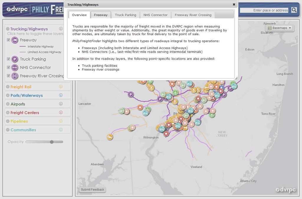
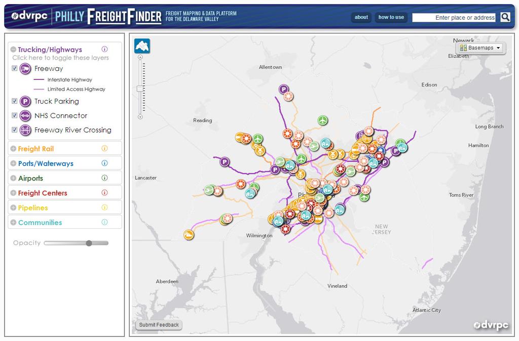
6 Components of the PhillyFreightFinder Focus on major infrastructure/facilities Regional importance 7 Freight Categories Trucking/Highways Freight Rail Ports/Waterways Airports Freight Centers Pipelines Community

7 Data Interface
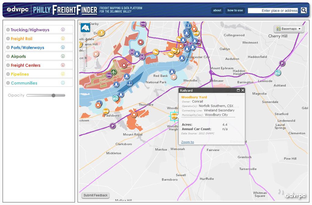
8 Data Interface Standard Data: Name Owner Operator Municipal Location Size
9 Data Interface Standard Data: Name Owner Indicators: Operator Facility Specific Municipal Capacity Location Size Activity Report Links
10 Preliminary Results Aggregation of new data types Segmentation of Infrastructure Building New Framework for Consistency Improved partnerships within region 230 acres of Rail Yards along 672 miles of Freight Rail ROW New Insights 13 General Cargo Ports with 5+ miles of berths and 23 cranes 1,122 Truck Parking Spaces at 14 facilities in 12 municipalities


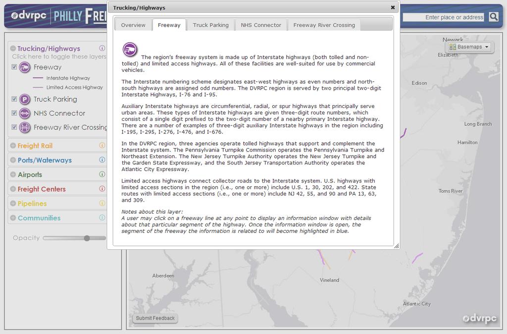
11 Trucking/Highways Freeways (Interstate + Limited Access) Capacity: Lanes Activity: AADT by Class Truck Parking Capacity: Designated Spaces Activity: Single Overnight Survey Count NHS Connectors Capacity: Lanes Activity: AADT by Class Highway River Crossings Capacity: Lanes, Height Restrictions Activity: AADT by Class Trucking/Highway Layers Lower Makefield Twp
 Capacity: Tracks, Weight, Double Stack")


12 Freight Rail Rail Lines (Interstate + Secondary + Industrial) Capacity: Tracks, Weight, Double Stack Activity: Tonnage, Train Count Grade Crossings Capacity: Tracks Activity: Tonnage, Train Count Rail Yards Capacity: Track Linear Feet, Acres Activity: Tonnage, Car Count Freight Rail Layers City of Philadelphia Intermodal Rail Yards Capacity: Loading Track (LF), Acres Activity: Tonnage, Car Count Rail River Crossings Capacity: Tracks, Weight, Double Stack


13 Ports/Waterways River (Delaware + Schuykill) Capacity: Channel Depth, Width, Air Draft Activity: Ship Count Anchorages Capacity: Length Activity: Annual Ships Port Terminals Capacity: Berths- count, length, depth; Cranes, Warehouse, Acres Activity: Ship Arrivals Ports/Waterways Layers West Deptford + Paulsboro


14 Airports Commercial Capacity: Runways-count, length; Acres Activity: Annual Operations Reliever Capacity: Runways-count, length; Acres Activity: Annual Operations Heliport Capacity: Acres Activity: Annual Operations Airports Layers Trenton


15 Freight Centers Mega Centers Capacity: Acres Activity: Employment Major Centers Capacity: Acres Activity: Employment Intermediate Centers Capacity: Acres Activity: Employment Freight Centers Layers Delaware County


16 Pipelines Pipelines Capacity: none Activity: none Due to concerns of security the data is mapped to 500 accuracy and contains limited information Pipelines Layers Mt Laurel

17 Community Freight as a Good Neighbor Project Narratives Community Layers Warminster Twp
18
19
20
21
22
23
24
25
26
27
28
29
30


31 as a good neighb Ongoing Data Program Annual maintenance and updates Expansion and refinement to match technical needs Responsive to national, regional and local trends/interests Essential to maintain utility Trucking/Highways Status Freeways Limited access freeways and Interstate routes Lanes 2012 DVRPC AADT incomplete DVRPC, PennDOT, NJ DOT 2015 Class Count/% truck incomplete DVRPC, PennDOT, NJ DOT 2015 FAF 2040 Projections missing FHWA FAF 2015 Speed/bottleneck Data missing ATRI Speed Data Truck Parking Private and public truck parking facilities Spaces 2009 DVRPC 2014 Trucks during overnight count 2009 DVRPC 2014 Ports/Waterways Status Sources N NHS Connectors All federally designated NHS/STRAHNET connectors Lanes 2012 DVRPC - AADT incomplete DVRPC, PennDOT, NJ DOT 2015 Class Count/% truck missing DVRPC, PennDOT, NJ DOT 2015 Highway River Crossings Super structure bridges spanning the Delaware or Schuylkill Rivers Lanes 2012 DVRPC - Height Restrictions unconfirmed Bridge Authorities 2015 AADT missing Bridge Authorities 2015 Class Count/% truck missing Bridge Authorities, DVRPC 2015 Weigh-in-Motion Stations Automated weigh-in-motion stations none none Delaware River Navigable river segments Channel width 2012 NOAA Channel depth 2012 NOAA Maximum air draft 2012 DVRPC/NOAA Annual Activity undefined Anchorages Desigated anchorages on the Delaware River Length 2012 NOAA Annual Ships 2013 Maritime Exchange Port Terminals Private/public port terminals for all cargo types Cargo Handled 2012 Port Operators Berths (count + length) 2012 Port Operators Cranes 2012 Port Operators 2 Warehouse space 2012 Port Operators 2 Acreage 2012 Port Operators 20 Ship arrivals 2013 Maritime Exchange 201 Rail Freight Status Sources Next Update Rail Lines All active freight rail trackage including share passenager lines Tracks 2012 DVRPC - DS Clearance incomplete Rail carriers k Capacity incomplete Rail carriers 2014 Tonnage missing Rail carriers 2014 Trains per day missing Rail carriers 2014 Class 1 Grade Crossing Class 1 grade crossings Tracks at crossing 2012 DVRPC - Trains per day missing Rail carriers 2014 Secondary Grade Crossing Includes grade crossings on secondary lines that intersect arterial roads Tracks at crossing missing DVRPC 201 Trains per day missing Rail carriers 20 Rail Yards Active rail yards Linear Ft of track missing DVRPC 20 Acres 2012 DVRPC Activity undefined 2 Intermodal Rail Yards Active intermodal rail yards Acres 2012 DVRPC Activity undefined Railroad River Crossings Super structure bridges spanning the Delaware or Schuylkill Rivers Tracks 2012 DVRPC DS Clearance incomplete Rail carriers Tonnage missing Rail carriers Trains per day missing Rail carriers Airports Status Sources Next Update Airports Active airport facilities designated as Commercial or Reliever Runways (#) 2006 DVRPC Aviation 2014 Runway length (range) 2006 DVRPC Aviation 2014 Acreage 2006 DVRPC Aviation 2014 Annual Operations 2006 DVRPC Aviation 2014 Freight Centers Status Sources Next Update Freight Centers DVRPC identified freight centers- landuses that contribute to freight activity Acres 2012 DVRPC, Member Govts Employment missing DVRPC, Member Govts, NETS Economic Activity missing DVRPC, Member Govts, NETS lines elines Status Sources munities
32 Improving Awareness Responsiveness to critical concerns Allows local and county to better evaluate capacities and potential performance impacts Framework for performance tracking and improvements Marketing the system Planners and decision-makers get a better understanding of the regional system Private business and partner access to information on system Economic development and business opportunities using data and visualizations
33 Questions/Comments Staff Contacts: Michael Ruane p. (215) e. Ted Dahlburg p. (215) e. DVGMTF: Task Force Co-chairs: Barry Seymour, DVRPC Gary DeBerry, PennDOT Data Subcommittee: Rick Crawford-Norfolk Southern, Chair e.