Transportation Standards TITLE 12 KLICKITAT COUNTY CODE
|
|
|
- Dora Norma Hensley
- 5 years ago
- Views:
Transcription
1 KLICKITAT COUNTY ORDINANCE NO Transportation Standards TITLE 12 KLICKITAT COUNTY CODE Klickitat County Public Works Department 115 S. Golden St., MSCH 19 Goldendale, WA Phone (509) FAX (509)
2 TABLE OF CONTENTS Chapter GENERAL PROVISIONS Short title General purpose Applicability Compliance required Maintenance of minimum requirements Interpretations Enforcement Severability Amendments... 3 Chapter DEFINITIONS AASHTO Adjacent Administrator Applicant's engineer AWWA Benefit area Berm Building County County Engineer County road Department Director Driveway Fire Department KCC Latecomer s Agreement Private road Public road Public water system Residential Zoning Districts Rural area UBC UFC Urban area Water purveyor... 6 Chapter ROAD STANDARDS General provisions Design control Roadway geometries Roadway elements Access and Intersections Structures Traffic control Fees, permits, specifications, and construction control Standard drawings Private roads - general requirements Chapter SPECIAL RESTRICTIONS Weight and speed restrictions Permits for restricted or closed roads Weight restrictions on bridges Chapter ROAD NAMING AND ADDRESSING Required review and action for road naming Application Page 1 of 33
3 Processing road name applications Road name appeal process Notification of road naming Address assignment program Address assignment Address application Assignment process Chapter PRIMITIVE ROADS Primitive roads designated Chapter FIRE PROTECTION STANDARDS Applicability Chapter LATECOMER'S AGREEMENTS Authority -Term Rights and nonliability of the county Eligibility of applicants Application Latecomer Agreement Procedure Execution, recording and notice Contract finality Standard Drawings TS-1 through TS-10 Page 2 of 33
4 Chapter GENERAL PROVISIONS Sections: Short title General purpose Applicability Compliance required Maintenance of minimum requirements Interpretations Enforcement Severability Amendments Short title This title and amendments thereto, shall be known and may be cited as "The Klickitat County Transportation Standards General purpose The general purpose of this title is to 1. Promote the public health, safety, and general welfare. 2. Assist in the implementation of the Klickitat County Comprehensive Plan, the Klickitat County Comprehensive Zoning Ordinance, and the Klickitat County Subdivision Ordinance for all areas under Klickitat County's land use regulatory authority and consistent with the provisions adopted by the county for the unincorporated urban growth area boundaries for the cities of Bingen, White Salmon and Goldendale. 3. Comply with the provisions and objectives of RCW and RCW 36.70A, as now or hereafter amended pertaining to planning under the Washington State Growth Management Act Applicability The requirements contained in this title shall apply to all subdivision and development of land in the unincorporated areas under Klickitat County's land use regulatory authority and consistent with the provisions adopted by the county for the unincorporated urban growth area boundaries for the cities of Bingen, White Salmon and Goldendale Compliance required No lot shall be created or altered except in compliance with the provisions of this title Maintenance of minimum requirements No required roadway or fire protection provision existing on or after the effective date of this title shall be reduced in area, dimension, volume, size and condition below the standards required by this title Interpretations The Director/County Engineer of the Public Works Department shall review and resolve any questions involving the proper interpretation and application of the provisions contained in Title 12, Transportation Standards. Administrative decisions shall be in keeping with the general purposes of this title as outlined above in section Enforcement The Director/County Engineer of the Public Works Department or his/her duly authorized agents shall have the authority and the responsibility to enforce the provisions contained in Title 12, Transportation Standards. No plans or development permits subject to the provisions of this title shall be approved unless such plans conform in all respects to the provisions of this title Severability If any provision of this resolution or its application to any person or circumstance is held invalid, the remainder of this resolution or application to other persons or circumstances shall not be affected Amendments Amendment to the text of this title may be initiated by the Board of Klickitat County Commissioners, Klickitat County Public Works Department, or the Klickitat County Planning Commission or staff. Page 3 of 33
5 Chapter DEFINITIONS Sections: AASHTO Adjacent Administrator Applicant's Engineer AWWA Benefit area Berm Building County County Engineer County road Department Director Driveway Fire Department KCC Latecomer's Agreements Private road Public road Public water system Residential Zoning Districts Rural area UBC UFC Urban area Water purveyor AASHTO American Association of State Highway and Traffic Officials Adjacent Abutting on public roads, streets, right-or-way or easements in which street system improvements are installed or directly connecting to street system improvements through an interest in real property such as an easement or l icense Administrator When used in this title the Administrator shall mean the Director of the Klickitat County Public Works Department Applicant's engineer A professional civil engineer licensed in the State of Washington AWWA American Water Works Association Benefit area That area which includes all parcels of real property adjacent to street system improvements or likely to require connection to or service by utility system improvements constructed by a developer Berm An earthen mound designed to provide visual interest, screen undesirable views, decrease noise or separate incompatible uses Building A structure designed for human occupancy, such as a residence or place of business, or other structures as determined by the Klickitat County Planning and/or Building Departments. Page 4 of 33
6 County When used in this title the County shall mean the jurisdictional boundaries of Klickitat County County Engineer When used in this title the county engineer shall mean The Klickitat County Engineer or authorized representative County road A road proposed for use by the general public whose construction or maintenance is the responsibility of Klickitat County Department The Klickitat County Department of Public Works, Office of the County Engineer Director When used in this title the Director shall mean the Director of Klickitat County Public Works Department Driveway A private road providing vehicular access to one parcel of property Fire Department The office of the applicable County Fire District KCC Klickitat County Code Latecomer s Agreement A written contract between the County and one or more developers providing partial reimbursement for cost of construction of street system improvements and/or utility system improvements to the developer by owners of property who are likely to utilize the improvements and who did not contribute to the original cost of construction Private road A road dedicated to exclusive limited use, under control of private individuals, and developed and maintained by those individuals who benefit from its establishment Public road A road proposed for use by the general public whose construction or maintenance may or may not be the responsibility of Klickitat County Public water system Any system or water supply intended to be used for human consumption or other domestic uses, including, but not limited to sources treatment, storage, transmission and distribution facilities where water is furnished to any community, collection or number of individuals, or is made available to the public for human consumption or domestic use Residential Zoning Districts Residential zoning districts include the following: Forest Resource District; minimum lot size, 20 acres (FR); Open Space District; minimum lot size, 20 acres (OS); Extensive Agriculture; minimum lot size, 20 acres or 40 acres where designated (EA); General Rural Zone; minimum lot size, 5 acres (GR); Rural Residential Zone; minimum lot size, 1 acre (RR1) 2 acres (RR2); Rural Center; minimum lot size, 5,000 square feet (RC); Residential Zone; minimum lot size 6,000 square feet (R); Suburban Residential District; minimum lot size 20,000 square feet (SR); Single-Family Residential District; minimum lot size, 10,000 square feet (R-1); Two-Family Residential District; minimum lot size, 6,000 square feet (R-2); Multi-Family Residential District; minimum lot size, 6,000 square feet (R-3); Resource Lands District; minimum lot size varies (RL); Rural District; minimum lot size, 10 acres (RRL). Note: Minimum lot sizes of 10,000 square feet or less require community water and sewer services Rural area Those areas of the county outside of an urban growth area as depicted in the Klickitat County Comprehensive Plan UBC Building Code Page 5 of 33
7 UFC The current edition of the Fire Code as adopted pursuant to Chapter 19.27RCW Urban area Those areas of the county within the city limits of an incorporated city within Klickitat County and the unincorporated portion of Klickitat County within an urban area boundary as established by the Klickitat County Board of Commissioners Water purveyor A federal, state, or county agency, or city, town, municipal corporation, firm, company, association, corporation, partnership, district, institution, person or persons owning or operating a public or private water system. Page 6 of 33
8 Chapter ROAD STANDARDS Sections: General provisions Design control Roadway geometrics Roadway elements Access and intersections Structures Traffic control Fees, permits, specifications, and construction control Standard drawings Private roads - general requirements General provisions 1. Authority Road standards, chapter is adopted under Title 12 of the Klickitat County Code by the Board of Klickitat County Commissioners pursuant to Chapter 36.86, Revised Code of Washington. Chapter , Revised Code of Washington, states in part that, "The County road engineer shall have supervision, under the direction of the board, of establishing, laying out, construction, altering, improving, repairing [and] maintaining all County roads in the county." To this end the county engineer for Klickitat County shall oversee all design and construction work related to county roads within unincorporated Klickitat County. The county engineer will be the final authority in resolving disputes concerning questions of fact in connection with standards for road and bridge construction not directly covered by this chapter, as set forth in RCW County roads, County legislative authority as agent of state standards. 2. Procedures Chapter 36.80, Revised Code of Washington, requires that Klickitat County employ a full-time county engineer who shall be a registered and licensed professional civil engineer under the laws of the State of Washington, and charges the county engineer with the responsibility to prepare standards of construction for roads and bridges. In the event that standards change to the degree that it becomes necessary to amend this chapter, the county engineer shall prepare and submit such recommendations for amendment to the Board of County Commissioners for their review and adoption in accordance with RCW It shall be the responsibility of the individual using this chapter to verify with the Department of Public Works that all technical requirements being used are the most current. 3. General Criteria A. This chapter establishes uniform technical requirements for road and bridge design, construction, and reconstruction. B. In establishing these uniform technical requirements, the county engineer has sought to encourage standardization of road design elements where necessary for consistency and to assure so far as practical that motoring, bicycling, and pedestrian public safety needs are met. Considerations include safety, convenience, aesthetics, proper drainage, and economical maintenance. C. The county's permitting and licensing activities require the adoption of specific, identifiable standards to guide individuals and entities in the administrative process of procuring the necessary County approval(s). The County must also maintain flexibility in carrying out its general duty to provide safe and adequate streets, roads, and highways to meet the needs of the traveling public and others that use the public right-of-way. Accordingly, this chapter is not intended to represent the legal standard by which the County's duty to the public is to be measured. D. The decision to use a particular road design element at a particular location should be made on the basis of an engineering analysis of the location. Thus, while this document provides minimum requirements for design, Page 7 of 33
9 it is not a substitute for professional engineering judgment. It is the intent that the provisions of this chapter be uniform in requirements for road design, but may not be appropriate for all locations and conditions. E. This chapter cannot provide for all situations. It is intended to assist, but not to substitute for, competent work by design professionals. It is expected that each professional will bring to each project the best of their skills and abilities. These uniform requirements are also not intended to unreasonably limit any innovative or creative effort that could result in the more effective and appropriate combination of design, cost savings, or both, provided that minimum standards are maintained. F. The applicant's engineer should take into account all available information and use the professional judgment that comes from training and experience to make the final design determination. There should be some record, not necessarily formal or cumbersome, of the matters that were considered during the design process that would justify the decisions that were made regarding the final project design. G. The county engineer will judge any proposed designs that depart from the requirements outlined in this chapter on the likelihood that such deviation will produce compensating or comparable results, adequate for the road uses and the general public. The county engineer will be the final authority in resolving disputes concerning questions of fact in connection with standards for road construction not directly covered by this chapter. 4. Applicability All requirements contained in this chapter, together with any and all amendments thereto, shall apply to all road, bridge, and other new construction of public and private roads in unincorporated Klickitat County consistent with the provisions adopted by the county for the unincorporated urban growth area boundaries for the cities of Bingen, White Salmon and Goldendale, and as far as practicable and feasible for reconstruction, resurfacing, restoration, and rehabilitation of existing public and private roads in unincorporated Klickitat County. In case of any ambiguity or dispute over interpretation of the provisions of this chapter, the decision of the county engineer shall be final. 5. R elationship to other documents A. The most current edition of the following publications and manuals are approved for use by the county engineer and may be used to supplement this chapter when a specific subject is not covered or discussed 1) Standard Specifications for Road, Bridge and Municipal Construction, as published by the Washington State Department of Transportation. 2) Standard Plans for Road, Bridge and Municipal Construction, as published by the Washington State Department of Transportation, under No. M ) Manual on Uniform Traffic Control Devices, as published by the U.S Department of Transportation, Federal Highway Administration, commonly known as the "MUTCD", as amended. 4) Standard Specifications for Highway Bridges, and any interim specifications, as adopted by the American Association of State Highway and Transportation Officials, as amended. 5) Construction Manual, as published by the Washington State Department of Transportation, under No. M41-01, as amended. 6) Local Agency Guidelines, as published by the Washington State Department of Transportation, under No. M36-62, commonly known as the "LAG Manual." 8) Special Report Highway Capacity Manual, as published by the Transportation Research Board, as amended. 9) Trip Generation, as published by the Institute of Transportation Engineers, as amended. B. The most current edition of the following publications are recognized by the county engineer as industry authorities and may be consulted on specific subjects not covered or discussed in this chapter or the above supplemental documents 1) A Policy on Geometric Design of Highways and Streets, as published by the American Association of State Highway and Transportation Officials, commonly known as the AASHTO Green Book", as amended. 2) Plans Preparation Manual, as published by the Washington State Department of Transportation, under No. M22-31, as amended. 3) Design Manual, as published by the Washington State Department of Transportation, under No. M22-01, as amended. 4) Bridge Design Manual, as published by the Washington State Department of Transportation, under No. M23-50, as amended. Page 8 of 33
10 5) Roadside Design Guide, as published by the American Association of State Highway and Transportation Officials, as amended. 6) Hydraulic Manual, as published by the Washington State Department of Transportation, under No. M23-03, as amended. 7) Design of Pavement Structures, as published by the American Association of State Highway and Transportation Officials (AASHTO). 8) Manual Of Instructions For The Survey Of The Public Lands Of The United States, as published by the Bureau of Land Management. C. The applicant's engineer may need to consult not only this chapter, but also a number of other Klickitat County documents. All road plans submitted to the county for review and approval shall be consistent with these other adopted county standards or ordinances, as amended. These documents or standards include, but are not limited to 1) Klickitat County Comprehensive Plan and applicable city comprehensive plans 2) Klickitat County Title 10 Vehicles and Traffic 3) Klickitat County Title 15 Buildings and Construction 4) Klickitat County Title 18 Subdivision 5) Klickitat County Title 19 Zoning 6) Washington State Environmental Policy Act (SEPA) and Title 20 Klickitat County Environmental Impact 7) Klickitat County Title 21 Flood Management 8) Klickitat County Title 22 Mobile Home and Recreational Vehicle Parks 9) Washington Administrative Code (WAC's). 10) Klickitat County Regional Transportation Plan 11) Klickitat County Paths and Trails Development Plan 12) Klickitat County Shoreline Master Plan 6. Legal References The governmental codes found in Table establish the county's right to establish design and construction standards. Table Governmental Code References Code Title of Code Description RCW County Roads - Standards Sets requirements to utilize adopted County road design standards under the direction of the county engineer. RCW Approaches to County Roads Outlines rules for construction of approaches to County roads and supervised by county engineer. RCW Roads and Bridges Engineer RCW Roads and Bridges Standards Outlines role of the County engineer and duties including preparation of design standards. Outlines minimum standards for counties to utilize. RCW43.32 County Road Design Standards Establishes design standards for County primary road system. The governmental codes listed in the above support the counties right to establish design and construction standards. Page 9 of 33
11 Design control 1. Functional Classification System A. The first step in the design process is to identify the functional classification of the roadway. The functional classifications of Klickitat County roadways are established as part of these transportation standards and defined further herein. A narrative of the existing and future adjacent land use and environment must accompany the proposal for functional classifications of new facilities. This narrative should answer questions such as but not limited to: Is the roadway in an urban growth area? What is the distance to nearby schools or parks? What is the expected pedestrian and bicycle activity? Will the roadway serve a residential, industrial or commercial site? B. Existing and future traffic volumes must be documented. The estimated future traffic volumes serve as the design year for the roadway. Interim designs are based on a 5 or 10-year traffic study. All interim designs must contribute to the 20-year roadway design. Roads and highways are most effectively classified by their function, according to the character of service they are intended to provide. The primary functions of roads and highways are to provide mobility and access. The degree to which these functions are provided is considered an integral part of classifying roads. The functional classification system creates a hierarchy of classified roads. C. For example, a freeway provides a high degree of mobility but very limited access, which is available only at interchanges that could be spaced several miles apart. Higher vehicle speeds and volumes are typical on these types of facilities and are; in fact, desirable. On the other hand, a local road within a residential neighborhood provides a high degree of access by way of numerous driveways to adjacent lots, and lower vehicle speeds and volumes are desired. Between these two extremes are the remainder of the roads, commonly called the arterial system, that must provide both mobility and access. D. Roads are grouped into a number of different classifications for administrative, planning, and design purposes. For example, the classification system can be used for planning for new routes, improvements to existing roads, and planning for area development in concert with the transportation network and providing minimum design standards or criteria to encourage the use of the road as intended. E. The main considerations for classifying roads into functional groups are the travel desires of the public, land service needs based on existing and expected land use, and the overall continuity of the system. A classification plan, which fits the various classes of roads together into a logical pattern and assigns realistic improvement standards to each class, will promote the highest overall level of service for the funds that are available. F. Klickitat County definitions for each functional classification are presented below. The Klickitat County Transportation Plan and the Klickitat County Paths and Trails Development Plan include transportation plans for modes other than passenger vehicles. These modal plans are intended to overlay onto the functional classification system. For example, the bicycle plan would overlay the functional classification system to identify those roadways that should include bicycle facilities as a design element of the roadway. G. The Klickitat County functional classification system directly addresses all roads in unincorporated Klickitat County that is under the jurisdiction of Klickitat County. State highways under the jurisdiction of the Washington State Department of Transportation are all legally designated arterials (RCW ). In some cases, particularly in rural areas of the county, no major county arterials are designated since the state highway route serves this function. 2. Functional Classification Definitions A. Principal Arterial: Principal Arterial streets and highways contain the greatest portion of through or longdistance travel. Such facilities serve the high-volume travel corridors connecting major generators of traffic and provide an integrated system for complete circulation of traffic, including ties to the major rural highways entering the urban area. Generally, major arterials include high traffic volume streets. Service to abutting land should be subordinate to the provision of travel service to major traffic movements; this service should be incidental to the primary functional responsibility of the road. B. Minor Arterial: Minor arterial streets and highways connect with the remaining arterial and collector roads that extend into the urban areas and serve less concentrated traffic generating areas such as neighborhood shopping centers and schools. Minor arterial streets serve as boundaries to neighborhoods and collect traffic from collector streets. Although the predominant function of minor arterial streets is the movement of through Page 10 of 33
12 traffic, they also provide for considerable local traffic that originates or is destined to points along the corridor. Minor arterials allow for more emphasis on land access than the major arterial system. They usually do not penetrate identifiable neighborhoods. C. Major Collector: These routes should provide service to larger towns not directly served by higher systems, and to other traffic generators of equivalent inter-county importance, such as schools, shipping points, county parks, important agricultural areas, etc. In addition, these routes should link larger towns and/or cities with routes of higher classification, and should serve the more important inter-county travel corridors. Collector arterials provide land access service and traffic circulation within residential neighborhoods, commercial, and industrial areas. They may penetrate identifiable residential neighborhoods. D. Minor Collector: These routes should be spaced at intervals, consistent with population density, collect traffic from local roads and bring all developed areas within a reasonable distance of a collector road. In addition, these routes should provide service to the remaining smaller communities, and link the locally important traffic generators with their rural heartland. E. Local Access: Roads not selected for inclusion in the arterial or collector classes are designated local access. They allow access to individual homes, shops, and similar traffic destinations. Direct access to abutting land is essential, for all traffic originates from or is destined to abutting land. Through traffic should be discouraged by appropriate geometric design and/or traffic control devices. 1. A local access cul-de-sac is a road with a single outlet. Direct access is provided from the stem and bulb. It serves less than 21 residences and has a typical ADT of 200 vehicles per day or less. A local access cul-de-sac is designed so that it cannot become a through road or a road of a higher classification. F. Fire Access Road: A private road serving two to four lots. 1. Dimensions: Fire access roads shall have an unobstructed width of not less than 20 feet of road surface and an unobstructed vertical clearance of not less than 13 feet 6 inches. Vertical clearances or widths shall be increased when in the opinion of the fire marshal, vertical clearances or widths are not adequate to provide fire apparatus access. 2. Surface: Fire access roads shall be designed and maintained to support the imposed loads of fire apparatus (80,000 pounds) and shall be provided with a surface so as to provide all-weather driving capabilities per Standard Drawing TS Turning radius: Roadway horizontal curves for fire access roads shall be designed to not have less than a 55-foot center line radii. 4. Dead Ends: Dead end fire access roads in excess of 150 feet in length shall be provided with approved provisions for the turning around of fire apparatus per Klickitat County turn-around standards found in Standard Drawing TS Grade: The gradient for a fire access road shall not exceed eleven (12) percent unless alternative fire protection procedures are proposed and approved by the fire marshal. 6. Obstruction and control of fire access roads: The required width of a fire access road shall not be obstructed in any manner, including parking of vehicles. Minimum required widths and clearances previously stated shall be maintained at all times. Entrances to roads, trails or other access ways, shall not be obstructed by parked vehicles or in any other manner. 7. Bridges: When a bridge is required as part of a fire access road, it shall be constructed and maintained in accordance with Klickitat County Public Works Engineering Design and Development Standards adopted by the county. The bridge shall be designed to carry an AASHTO (American Association of State Highway and Transportation Officials) HS live load or greater, sufficient to carry the imposed loads of fire apparatus. Vehicle load limits shall be posted at both entrances to bridges. 3. Right-of-way Pursuant to RCW , the Board of Klickitat County Commissioners has set the minimum right-of-way width to be 60 feet. Road right-of-way must be wide enough to construct and maintain cut and fill slopes, ditches and utilities. Additional right-of-way shall be dedicated if necessary. Page 11 of 33
13 4. Design Vehicle A. The physical characteristics of vehicles and the proportions of variously sized vehicles using the road system are positive controls in geometric design. It is necessary to examine all vehicle types, select general class groupings, and establish representatively sized vehicles within each class for design use. Design vehicles are selected motor vehicles with the weight, dimensions, and operating characteristics used to establish road design controls for accommodating vehicles of designated classes. For purposes of geometric design, each design vehicle has larger physical dimensions and larger minimum turning radius than those of almost all other vehicles in its class. B. C. Three general classes of vehicles have been selected, namely, passenger cars, trucks, and buses/recreational vehicles. The passenger car class includes compacts and subcompacts plus all light vehicles and light delivery trucks (vans and pickups). The truck class includes single-unit trucks, truck tractor-semitrailer combinations, and trucks or truck tractors with semitrailers in combination with full trailers. Buses/recreational vehicles include single unit buses, articulated buses, school buses, motor homes, and passenger cars or motor homes pulling trailers or boats. In addition, where provision is made for bicycles on a road, the bicycle should also be considered a design vehicle. The dimensions for 15 design vehicles representing vehicles within these general classes are given in the AASHTO Green Book. In design of any road facility the largest design vehicle likely to use that facility with considerable frequency is used to determine the design of such critical features as radii at intersections and radii of turning roadways. Design vehicle profiles can be determined from the dimensions in the AASHTO Green Book. Although the applicant's engineer should develop a design in accordance with the anticipated composition of traffic likely to use the facility, the typical design vehicle using AASHTO Green Book nomenclature for each road class is as follows in table Design Speed Table Road Classification Design Vehicles Arterials Bus/WB-50 Principal Bus/WB-50 Minor Bus/WB-50 Major and Minor Collectors SU/Bus Local Access Roads SU/P Geometric design features of a road facility should be consistent with the design speed appropriate for the facility. It should be noted, however, that the design speed does not necessarily represent the anticipated operating or posted speed. The Design Speed for each road class is as follows in table Traffic Characteristics Table Road Classification Design Speed Arterials Urban Rural Principal 45 mph 45 mph Minor 40 mph 45 mph Collectors 35 mph 40 mph Local Access Roads 35 mph 35 mph Cul-de-sacs 25 mph 25 mph Fire Access Roads 20 mph 20 mph A. Trip Generation Trip Generation, as published by the Institute of Transportation Engineers shall be used when developing traffic generation volumes. B. Design Volumes Page 12 of 33
14 Roads and streets should be designed for a specific traffic volume range, using the projected ADT for a design year 20 years hence. Current and future land use trends should also be considered in making these decisions, and should reference the Klickitat County Comprehensive Plan for future land use analysis. On some low volume facilities, traffic volumes may not normally change significantly for the foreseeable future. In an urban environment these would typically be relatively short streets that are not likely to be extended. In rural areas they most likely would be remote agriculture or natural resource access roads where there is little or no likelihood of land use change. C. Capacity Level of Services Special Report 209 Highway Capacity Manual shall be used when analyzing capacity of roadway or intersection operation. D. Truck Facilities Truck turning radii as detailed in the AASHTO Green Book should be provided where significant volumes of heavy trucks are expected. Truck climbing lanes, where warranted, shall be provided as detailed in the AASHTO Green Book. E. Bus and Mail Delivery Turnouts If required by the county, bus and mail turnouts shall conform to Standard Drawing TS Pedestrians Ped estrian facilities shall be provided in any Klickitat County urban area, within a 1-mile radius from a school, and/or where other pedestrian traffic warrants. Curbed sidewalks may be required on both sides of any newly constructed road within 1-mile radius of a school, or where significant other pedestrian traffic warrants within existing developed rural areas. Sidewalks, curb ramps, etc. shall conform to the requirements of the Standard Plans for Road, Bridge and Municipal Construction. A. Walkways and Trails Walkways and trails are not normally expected, except in situations where the facility is part of an adopted plan or otherwise required as a condition of approval for a development permit. If required by the county, such a facility design shall be coordinated with the county engineer in order to receive specific design direction and parameters. 8. Bicycles Bicycle facilities are not normally expected except in situations where the facility is part of an adopted bicycle trail plan. It may be necessary to provide a widened lane or shoulder, appropriate drainage grates, or other bicycle facilities as required by the Counties Paths and Trails Development Plan. If required by the county, such a facility design shall be coordinated with the county engineer in order to receive specific design direction and parameters. 9. Safety When designing a road for new construction or reconstruction, the engineer must keep in mind the desire to provide opportunities to enhance safety of the roadway operation. This is particularly important when designing minor reconstruction, resurfacing, restoration, or rehabilitation projects on existing roads. Potential safety enhancements can be achieved through examining the following possibilities. A. Upgrading existing design elements such as alignment, grades, widths, sight distance, clearances, bridges and the pavement structure including surface texture. B. Upgrading existing operational features such as traffic control devices, left and right turn lanes, and pedestrian/non-motorized element accommodations that provide for the safe and efficient movement of vehicles and pedestrians/non-motorized elements. C. Reducing the potential hazard of existing roadside features such as side slopes, ditches, drainage facilities, vegetation, and other features adjacent to the road. D. U pgrading bridge safety features such as bridge rails, approach rails, connections and terminals. 10. Traffic Analysis Page 13 of 33
15 Any land use application that will create more than 40 Average Daily Trips (ADT) as determined by the Trip Generation Manual shall submit a Transportation Impact Study. A Transportation Impact Study (TIS) is an important tool used to determine the impact of a proposed land development project, and to identify the need for any improvements to a transportation system to reduce congestion, maintain and improve safety, and provide site access and impact mitigation associated with the project. TIS reports will be used as the basis of determining traffic impact fees, of assessing developer contributions to roadway improvements, and determining the appropriate roadway standards improvements associated with a development permit. The TIS should start in the earliest planning stages of a project, including site selection. The TIS shall be undertaken in advance of submitting an application. The traffic study should include the following documentation: A. A description of the proposed land uses and a site plan, including the number and location of driveways, parking needs, pedestrian improvements, and truck access. Also include an analysis and identification of the area influenced by the development. B. Description of the existing roadway conditions such as traffic volumes, transit accessibility, accident history, roadway geometrics, pedestrian needs and overall traffic operations and circulation. C. Identification of traffic congestion, accident areas and other deficiencies of the transportation system in the study area. D. Anticipated nearby land development (potential allowed by zoning, planned or under construction) and associated traffic, and overall traffic growth trends in the area. E. Anticipated trip generation, and daily and peak-hour traffic volumes of the proposed development at full build and at any interim construction phase. F. Identification of traffic congestion, safety problems and/or other deficiencies of the future transportation system, with and without the proposed development, including identified transportation improvements being planned by other public or private organizations that are expected to be in operation in the future years under study. G. Development and evaluation of potential improvement measures needed to mitigate the impact of the development to the level defined by local/state policies. H. Development and evaluation of potential improvement measures needed to mitigate the impact of the development to the level defined by accepted engineering practices. I. Identify transportation improvements that achieve the needed level of site access and mitigate any adverse effectsthe development related traffic might have on the transportation network. Sufficient detail should be included so the reviewing agencies, Planning Commission, Board of County Commissioners and the public will be able to follow the methodology of the analysis and associated finding and recommendations. J. Identify the Level Of Service (LOS) for all arterials and transit routes identified in the area influenced by the development using the methodology outlined in the Highway Capacity Manual. 11. Environmental If required an environmental checklist shall be submitted to the county environmental official for the work shown on the road and/or storm drainage construction plans submitted to the county for review and approval unless the proposed work is part of a project for which an environmental checklist has already been submitted or the work is categorically exempt per Klickitat County Environmental Regulations, Chapter or Chapter WAC. An environmental determination must be issued for the work and any comment period and appeal periods must have expired before the project plans receive final approval by the county Roadway geometries 1. Sight Distance A. The AASHTO Green Book contains a discussion of the factors and assumptions associated with the calculation of stopping, passing, and intersection sight distance. Stopping sight distance is a vital consideration for both urban and rural situations. Passing sight distance will likely be pertinent only in rural situations. Intersection sight distance must be considered in light of the terrain in which the facility is located, Page 14 of 33
16 and in urban situations to what extent parking is permitted. Where the improvement contemplates some kind of pavement, the simplest approach is to base the design on stopping sight distance and intersection sight distance, and to control passing situations with appropriate striping. Stopping Sight Distance shall be available throughout all horizontal and vertical curves. Minimum Stopping Sight Distance (SSD) shall be designed for wet pavement as follows in table Table Design Speed (mph) Stopping Sight distance (feet) Values are based on an object height of 0.5 feet and a driver's eye height of 3.5 feet. The effects of grade must be accounted for through the use of a correction factor for down grades steeper than 3% as follows in table : Table Design Stopping Sight distance (feet) Speed (mph) 3% 6% 9% 20 mph mph mph mph mph mph B. Road Approach Sight Distance must be equal to or exceed the required sight distance listed below in table for the legal posted speed limit. Sufficient sight distance in each direction along a public road must be provided to permit vehicles to safely enter the roadway. Road Approach Sight Distance for all movements shall be designed for the posted speed of the facility being entered as follows, unless unusual design or safety considerations warrant increased sight distance requirements as determined by the county engineer: Table Road Approach Sight Distance (feet) Posted Speed (mph) Sight Distance Values are based on drivers eye height of 3.5 feet set back at least 10.0 feet from the edge of traveled way and an object height o f 4.25 feet. Road approach sight distance must be calculated for situations that involve road approach grades in e xcess of 6% to account for the reduction in vehicle acceleration and deceleration. In situations where the road approach sight distance is questionable, the county engineer may require the applicant's engineer to prepare an road approach sight distance diagram, together with appropriate field measurements, and submit them for review prior to the approval of the construction plans. The diagram and measurements shall be stamped and signed by the applicant's engineer. Exiting sight distance for vehicles on the major road to view an oncoming vehicle traveling at the speed limit and turn safely onto a minor road or driveway shall be made available. Design analysis should be similar to that used for road approach sight distance. Passing Sight Distance shall be provided for where determined by the county engineer. 2. Horizontal Alignment The road construction centerline must match as much as possible the right-of-way centerline, unless otherwise approved by the county engineer. On most roads, especially those classified as local roads where design speeds are in the mph range, short radius curves may be tolerated and the superelevation may not be necessary. On roads where design speeds may be over 35 mph, horizontal alignment becomes a most important consideration. Each individual road, however, is unique and must be carefully evaluated to ensure appropriate alignment. The computations involving curve radius Page 15 of 33
17 and superelevation are important elements in the design process and are well detailed in the AASHTO Green Book. The design for horizontal curvature shall be determined using the following formula R min = V 2 / 15(e+f) Where R min = minimum radius V = Design speed e = Superelevation f = Maximum side friction factor The design shall conform to the use of the following maximum side friction factor values shown in table Table Design Speed (mph) Rural 'f' Urban 'f' The normal roadway crown slope for new construction is 2% unless the road is in superelevation or an intersection design requires a varying slope. When widening of an existing road is being done, a maximum of 6% cross slope will be permitted. Grinding and/or overlaying as applicable will be required if the cross slope will exceed this amount. The maximum superelevation rates "e" are as follows in table Table Road Maximum 'e' (feet/foot) Classification Rural Urban Arterials Collectors Local Access Roads Cul-de-sac No super allowed When superelevation is used, the required superelevation runoff length shall be provided in accordance with AASHTO Green Book, and distributed in accordance with Design "A" contained in the WSDOT Design Manual. Curve widening shall be considered and design, when warranted, in accordance with the AASHTO Green Book. 3. Vertical Alignment In an urban curbed low volume street situation the minimum acceptable grade to assure proper drainage is an important consideration. Tolerable maximum grades will vary with road use. Intersections on steep grades shall not be permitted. In urban areas ease of access for emergency vehicles is also to be considered when establishing grades. For rural projects, the AASHTO Green Book includes tables of maximum grades related to design speed and terrain. The design of crest and sag vertical curves is related to design speed and is important in rural projects with higher design speeds. The AASHTO Green Book is the best source for this process and for the integration of vertical and horizontal curvature. A. Grade The maximum gradient on any new or reconstructed road shall not exceed the following grades in table Table Road Maximum Grade (%) Classification Urban / Rural 20 mph 30 mph 40 mph 50 mph Arterials Collectors Local Access Roads Fire Access Roads 12 Page 16 of 33
18 For streets in commercial a nd industrial areas, gradient design desirably should be less than 8 percent, grades should desirably be less than 5 percent, and flatter grades should be encouraged. The centerline and gutterline gradient of any road shall not be less than 0.7% when a cement concrete gutterline is used. The centerline gradient of any road shall not be less than 0.7% when drainage is not contained. All changes in grade greater than 1 % shall be connected by a vertical curve. B. Vertical curves Vertical Sag Curve design shall be based on an assumed non-illuminated roadway's visibility which should be long enough so that the automobile light beam distance is nearly the same as the stopping sight distance. Vertical Crest Curve design shall be based on stopping sight distance for wet pavement. All vertical curves shall be designed per the AASHTO Green Book. All vertical curves must be symmetrical parabolic curves. Design speeds for vertical curves located within the area controlled by a STOP sign can be reduced in accordance with the anticipated speed of the vehicle approaching the STOP control Roadway elements 1. Drainage All drainage design calculations and sizing must meet or exceed a 50-year flood capacity. All roadways must have adequate crown or adequate cross-slope to get water off the roadway. Careful cross-slope design is especially important at the ends of horizontal curves with superelevation and at intersections. It must be recognized that many drainage ditches and headwalls are usually in the clear zone, or recovery area, which is an important roadway safety feature. In curb and gutter situations, especially where grades are at or near recommended minimums, the location and design of inlets becomes very important. All drainage elements associated with the roadway design and construction or draining into or out of the roadway and within the project boundaries shall be designed in accordance with the requirements of the Hydraulic Manual. All private storm water management systems shall be located outside the county road right-of-way. Maximum length of surface drainage for thickened edge pavements or curb sections shall not exceed 300 feet, unless otherwise approved by the county engineer. Maximum spacing between catch basins shall not exceed 300 feet, suggested catch basin spacing and percent grade shall be as follows: Corrugated metal pipe, concrete pipe, or any other type approved by the county engineer may be used for drainage pipe. All concrete culvert pipe, except when used for individual driveways on ditched roadways, shall be grouted. Tw elve-inch minimum culvert pipe is to be used between inlet and catch basin. Catch basins may be poured in place, concrete block or precast, in accordance with approved plans. For depths over 5 feet to flowline, standard manholes or type 11 catch basins will be required. All drainage must be shown on the roadway plan and shall be submitted to the county engineer for approval prior to construction. Lined ditches may be required on grades over 8%. Drainage easements shall be indicated, both on final map for recording and the plan and profile sheet. 2. Utilities and Easements 150 ft % to 1.5% and 12.0% or greater 200 ft % to 3.0% and 8.0% to 12.0% 300 ft % to 8.0% All public or private utility installations shall conform to the requirements outlined in the franchise agreement between the utility company and Klickitat County. Any new utilities shall be located underground wherever possible. Any work within the county road right-of-way not performed under a franchise agreement shall require a permit issued by Public Works. Improper location or construction of utilities will be sufficient reason for the refusal of the county to accept a road for dedication and maintenance. Utility trenching or transverse cuts in new county roads will be discouraged. They will not be permitted unless it can be shown that alternatives such as boring or jacking or relocating outside the paved roadway area is not feasible unless the utility can be installed just prior to reconstruction or overlay of the road. Page 17 of 33
19 A. Public Utilities Easements for public utilities shall be provided along front, side and/or rear property lines in keeping with the needs of the respective public utilities distribution engineers along with any necessary construction and access easements. Easements shall be a minimum of five (5) feet in width. Where practicable, the width of rear and side lot line easements shall be shared equally by abutting lots. Easements shall be continuous and aligned from block to block within the subdivision and with adjoining subdivisions. B. Unusual Facilities Easements for unusual facilities such as high voltage electrical transmission lines, drainage canals, wetlands, storm water detention facilities, and others, shall be of sufficient width, length and location as is appropriate to carry out their purpose, including any necessary access easements. C. Underground Utility Installations Utility lines, including, but not limited to electricity, communications and street lighting serving and located within the subdivision shall be placed underground. Where topography, soil conditions or other circumstances make underground installations impractical, the board, upon recommendation of the planning commission, may waive this requirement if it finds upon written evidence presented by the supplier of such utilities, that under-grounding is impractical. D. Watercourses Where a subdivision is traversed by a watercourse, a drainage easement adequate for the purpose and conforming to the line of such watercourse, drainage way, waste way, channel or stream and of such width for construction, maintenance and control as determined by an engineer, shall be provided. 3. Pavement Road surfacing depths on county roads shall be determined by pavement design and approved by the county engineer. Design shall be based on existing soil conditions and traffic data. Soil analysis will be required prior to making this determination. In no case shall the total depth of crushed surfacing aggregate be less than 0.75 feet. Crushed surfacing shall be made up of a minimum of 0.5 feet compacted depth of crushed surfacing base course, and 0.25 feet compacted depth of crushed surfacing top course. Either 2½ inches compacted depth of asphalt concrete Class A or a two shot bituminous surface treatment shall complete the paving course. All asphalt paving shall meet the compaction requirements determined by the Washington State Department of Transportation Standard Specifications. Pavement design for all roads shall be for a 20-year performance period. Design criteria and standards established by AASHTO, WSDOT, the Asphalt Institute, or other nationally recognized organizations shall be used to determine paving and subgrade depths and types of materials for the roadway section. Non-destructive testing or falling weight deflectometer or a modulus value established by a geotechnical engineer shall be used to determine the materials characterization of the existing soils conditions for the pavement design. 4. Lane Widths Travel lanes shall be a minimum of 10 feet wide, 12 feet being desirable. Exclusive turn lanes or two-way left-turn lanes shall be as shown in the Washington State Department of Transportation Design Manual. Widened curb lanes, when required, shall be as shown in the Washington State Department of Transportation Design Manual. 5. Shoulders All roadway shoulder widths are to be determined by the anticipated Average Daily Traffic. 6. Curbs An acceptable design for concrete curb and gutter is provided for in Standard Drawing TS-4. Curb and gutters are required on both sides of any newly constructed road, in urban developments located in urban growth areas of Klickitat County. 7. Sidewalks and Pathways Page 18 of 33
20 Concrete sidewalks, walkway and trails, shall conform to Standard Drawing No. TS-5 or TS-6. Sidewalks are required on any newly constructed road, located in urban areas of Klickitat County, or within a 1-mile radius of a school, or where significant pedestrian traffic warrants within existing developed rural areas. 8. Buffers and Medians A buffer is that area between the back of curb and near edge of sidewalk or walkway. The maximum width shall be 12 feet and the minimum width shall be 4 feet. The maximum height of vegetation, except for street trees, placed in a buffer shall be 18 inches above the top of curb provided no safety-related concern is created. The county engineer shall not allow plants within the buffer area where safety or visibility concerns exist. Storm drain percolation systems shall not be permitted under or within any buffer area located within the county road right-of-way. 9. Clear Areas The designer must be aware of the extensive tables of recommended clear zone distances both in the AASHTO Green Book and LAG Manual. It must also be recognized; however, that serious accidents on low volume roads, especially on those below 200 ADT, are rare occurrences. At this low end of the scale, the cost of providing the recommended clear zone may be prohibitive. Research undertaken to re-evaluate the safety needs on low volume rural roads states that the suggested values for side slopes and clear zones should be recognized as idealistic objectives. A more realistic approach to roadside safety on low volume roads should depend on achieving a balance between the cost and the safety effectiveness of the design treatment. It is further stated that, while the application of such an analysis to low volume roads indicates that individual roadside safety treatments yield very small safety contributions, some low cost improvements do appear to be cost effective especially on the outside of curves. The removal of certain trees and relocation of utility poles are recommended. Also cited as being cost effective are the placement of guardrail on steep slopes, removal of unnecessary guardrail on flat slopes, and the flattening of steep but low embankments. In this regard it is most important that the designer is aware not only of pertinent published recommendations, but also of research done subsequent to their adoption. In the final analysis the designer must apply his or her own professional judgment in making the final design decisions, and be prepared to defend and justify them if necessary. 10. Roadside A. Cut/Fill Slopes Side slopes shall be constructed no steeper than 3 H : 1 V for Arterials and Collectors and 2 H : 1 V for Local Access Roads. Cut slopes shall be no steeper than 2 H : 1 V. Steeper slopes may be allowed in areas where a stable rock face exits. Flatter slopes are preferred and will be required if a geotechnical report indicates that the earth is unstable and subject to sliding, sloughing, or erosion. Fills will be constructed using materials, compaction methods, and construction techniques ensuring stable fills are created. Side slopes shall be stabilized by grass sod, hydroseeding, by other planting, or surfacing materials, or by the use of other material types acceptable to Klickitat County. Side slopes may also have to be flattened to accommodate utility placement. B. Guardrails AASHTO, Roadside Design Guide, and WSDOT s design manuals shall be used as a guide to determine the need for guardrail and the design. If it has been established that guardrail is warranted on a particular improvement the designer must determine the best location, and type of construction that would be most appropriate for the function and anticipated traffic volume of the facility. The designer should be aware that warrants and designs developed for high volume, high-speed facilities are not necessarily appropriate for low volume and/or low-speed locations. C. Landscaping Street trees and other vegetation located within the county right-of-way require a permit from Klickitat County. No trees having a mature diameter of 4 inches or more measured at 6 inches above the ground surface shall be planted in the clear zone of the road. Additionally, street trees used within county right-of-way shall not conflict with overhead utilities, traffic control devices, sight distance or visibility requirements, and root development shall not conflict with underground utilities, pavement, curbs, sidewalks, walkways, trails, or storm Page 19 of 33
21 drainage facilities. Irrigation systems not specifically permitted or licensed by the county engineer must be installed on private property. D. Mailboxes Mailboxes shall be installed with safety for the patron, mail carrier and highway traffic. Boxes should be placed only on the right-hand side of the roadway in the direction of travel of the carrier. When a mailbox is installed in the vicinity of an existing guardrail, it shall be placed behind the guardrail. All exposed mailboxes shall be firmly attached to supports that yield or break away safely if struck by a vehicle. Multiple mailbox installations shall not use a heavy horizontal support member. The use of cantilevered mailbox supports is encouraged in order to minimize conflicts with snowplowing activities Access and Intersections 1. Access Control Intersection location, spacing, and design are fundamental to the management of access and preservation of capacity provided for in the roadway design. The functional classification of each roadway addresses the appropriate level of access control for that roadway. The county engineer may require the applicant's engineer to furnish an access plan that will be used by the county to review what impact the proposed access will have on the county road system. For proposed access approaches on to any road, the intersections created are classed into two types, roadways and driveways. Driveway design criteria will be used for residential and commercial driveway approaches as outlined below. Roadway intersection design criteria will be used whenever an approach roadway intersects another road, or if traffic signalization is warranted as defined in the current edition of the Manual on Uniform Traffic Control Devices. All roadway intersections, public or private, will use roadway intersection design criteria. When a three or more lane approach is requested, a traffic engineering study along with a signing, striping and traffic channelization plan shall be completed by the applicant's engineer. The adequacy of all criteria given in this section to the particular situation in question shall be checked by an appropriate engineering analysis. These criteria are minimum guidelines only and may be modified according to traffic volumes and mix, topography, design speed, design vehicle requirements, and other conditions. A. General Criteria Standard drawings are provided for residential driveway approaches, and commercial driveway approaches. Roadway and driveway approaches, public or private, shall be designed so as to provide adequate entering sight distance in both directions on the roadway being accessed, and so as not to interfere with drainage. For both roadway and driveway intersections, the following general design criteria shall apply: 1) Intersections should not be located on or near sharp curves, i.e., curves with radii close to the AASHTO Green Book minimums. Intersections should be located sufficient distance from all curves to provide proper sight distance for vehicles on the intersecting road or driveway and on the through road. 2) Multi-leg intersections (i.e., those with more than four legs) are not permitted within local road networks. In local road networks "T" and L intersections only are encouraged. For arterial access, four-leg intersections are encouraged. 3) Whenever a potential feasible access exists to any property from two or more roads, the county engineer 4) may refuse access to the higher classified road. Wherever a potential feasible access exists to any property from both a public road and private easement, the county engineer may refuse access to the public road. 5) New access locations internal to the platting of property shall be unified whenever possible to create the fewest number of access points onto a road if they access roads of a classification higher than a local access road. If required by public works the applicant's engineer shall submit a Lot Access Plan that demonstrates that each lot is accessible by a county standard road approach driveway. This Lot Access Plan shall be submitted to public works for review before any public hearing. Lots of record in existing formal plat subdivisions, short plats and large lots not served by a minor or major driveway shall be permitted a minimum of one residential driveway. 6) The intersection of two local roads should be designed to operate with the appropriate traffic control device (e.g., Stop or Yield signs) whenever possible. Page 20 of 33
22 7) Intersections within the subdivision should be of the "T" type; for lower speed facilities of minor or cul-de-sac classification L type intersections are acceptable. Four legged intersections within the subdivision must receive the approval of the county engineer. 8) Access to corner lots should be from the lesser-classified road, at the greatest distance possible from the intersection. 9) The number of intersections should be minimized as much as possible, particularly as classification of the affected roads increases. Intersection spacing should be maximized wherever possible. B. Spacing Notwithstanding the requirements of this section, the number and location of intersections may be more restrictive than described herein if deemed necessary by the county engineer. The county engineer shall base the determination on existing and projected traffic volumes and channelization and signalization on the existing county road, traffic, and turning movements generated by the existing and/or proposed project(s), and other applicable traffic design criteria as well as other driveways in the vicinity of the proposed access approach, the amount of lot frontage along the road, and channelization/traffic control. In order to minimize the number of conflicts between vehicles entering and exiting the roadway and vehicles traveling along a roadway, the engineer should maximize the distances between driveways along the roadway. The minimum spacing distance for a commercial driveway approach to any roadway is 125 feet. As well, minimum distances between roadways, measured from the centerline of the roadway at the extension of the right-of-way line, shall apply for either same side or opposite sides of the primary street as shown below in table Table Road Classifications Minimum Distance Between Roads Local/Fire Apparatus Roads 125 Feet Intersecting Local/Fire Apparatus Roads Local/Fire Apparatus Roads 250 Feet Intersecting Arterials Arterials Intersecting Arterials ¼ Mile 2. Driveways No person, party, firm, corporation, or entity shall construct, repair, or alter any approach from any abutting property to any county road located in unincorporated Klickitat County, permanently or on a temporary basis, without first obtaining or having a Driveway Approach Permit from the county engineer. A copy of each Driveway Approach Permit shall be available for inspection at the site during the life of the permit. Driveways are deceptively simple in appearance and often do not receive the design consideration that they merit. Commonly overlooked design issues include inadequate radii at the intersection with the roadway, excessive approach grades and grade changes within the driveway approach area, inadequate width, and inadequate entering sight distance. Driveway design needs to address the type of vehicle composition anticipated, traffic volume and land use activities being accessed. Driveway placement needs to be carefully determined to minimize interference with normal roadway operation. Driveways need to be constructed where entering sight distance in conjunction with driveway access would be adequate for safe traffic operations. Closely spaced driveways are discouraged. The design of the driveway approach is broken into two general classifications, Residential Driveway Approach and Commercial Driveway Approach. A Residential Driveway Approach is used to serve one single-family residence on one lot. A Commercial Approach is used for multi-family, and commercial uses. When multi-access serve one site then each driveway approach shall conform to the applicable use criteria. points are desired to A. Residential Driveway Approach Page 21 of 33
23 Residential Driveway Approaches shall be constructed in accordance with Standard Drawing No. TS-7. Grading and restoration of the driveway beyond the end of the driveway approach shall be done to provide a smooth, passable, and safe transition to the existing facility. Residential Driveway Approaches shall be constructed the maximum practical distance, but in no event, less than thirty-five feet from an arterial or collector road intersection; or less than twenty-five feet from a local road or cul-de-sac intersection. The distance is measured along the property line from the intersecting road right-of- way line to the nearest edge of the driveway width. Residential Driveway Approaches shall not be spaced closer than seventy feet, measured centerline to centerline from another residential approach. Adjacent lot driveways may be allowed where topography or other circumstances limit spacing. B. Commercial Driveway Approach Commercial Driveway Approaches shall be constructed in accordance with Standard Drawing TS-8. Grading and restoration of the driveway beyond the end of the driveway approach shall be done to provide a smooth, passable, and safe transition to the existing facility. Commercial Driveway Approaches must be located a minimum of one hundred twenty-five feet from an intersection, except where physical site conditions and spacing of existing driveway approaches may cause the county engineer to require another location. The one hundred twenty-five feet is measured along the property line from the intersecting road right-of-way line to the edge of the driveway width. New driveway approaches that would create a four-legged intersection are undesirable except on roads, which have an arterial classification. Access to a corner lot with a frontage less than one hundred fifty-five feet in width will be established on a case-by-case basis by the county engineer and the driveway approach shall be placed at such a location to maximize safety. The number, location, and size of Commercial Driveway Approaches shall be determined by the volume and type of traffic generated by the development, other driveway approaches in the vicinity of the proposed approach, the amount of lot frontage along the road, and channelization/traffic control on the road along the lot frontage. When multiple Commercial Driveway Approaches to one parcel or development are permitted, they shall not be less than one hundred twenty-five feet apart, measured from centerline to centerline. C. Construction Criteria The outer edge of a driveway approach shall not be constructed closer than seventy feet to a bridge, or other structure that may warrant end protection using guardrail in accordance with the most current criteria adopted by the Washington State Department of Transportation. All commercial driveway approaches shall be paved to the end of the 35-foot radius, with a minimum of 2 inch compacted depth of asphalt concrete if the existing road is paved. If the existing road is gravel crushed surfacing top course is acceptable. The minimum distance between the paved edge of a driveway approach and the face of an obstruction, including existing utility appurtenances which may cause a traffic safety concern may be no less than four feet without curbing and three feet with curbing on the approach. Obstructions located closer than these distances which may cause a traffic safety concern must be relocated. 3. Roadway Intersections Roadway intersection guidelines encourage the preservation of capacity and safe operation of roadways. The following subsections provide the guidelines for roadway intersection location and design. A. Angles Proposed roads must intersect one another at 90-degree angles or as close to 90 degrees as topography permits. If 90 degrees is not possible, the skew angle shall not vary more than 15 degrees from right angles (75 degree minimum). B. Corner Radii At road intersections, the following typical ranges of curb line radii are permitted as shown in table : Table Page 22 of 33
24 Road Classification Local Road Local Road Intersection Local Road - Arterial Intersection Arterial - Arterial Intersection Curb Line Radii 25 feet feet feet Corner radii outside of the above ranges should be considered if the anticipated composition of traffic warrants such a need. C. Geometrics When either of the road centerline profile grades within 35 feet of an intersection have a gradient of 8% or more, an intersection detail drawn to a scale of 1" = 20' must be included as a detail on the road construction plans. The detail will show spot elevations every feet on the road centerline, around the curb return, and grate elevations for drainage structures in the intersection. The intersection plan must be clearly detailed to show flow line grades and how surface drainage will be controlled at the intersection. Curb return data for lesser gradients shall be shown on the road construction plans. At the intersection of different classifications of roads (e.g. a collector with a local access), the centerline slope and typical cross section of the higher classified road should be carried through the intersection with the lower classified road matching in a manner which will not interfere with the smooth movement of traffic in the travel lanes of the higher classified road. Where two roads of the same classification intersect, the centerline grade shall be matched at the center of the intersection with cross slopes varying through the intersection to allow drainage. All classes of local roads shall be treated as the same classification for purposes of this paragraph. Profile grades for all roads (public or private) intersecting onto a County road (existing or proposed) shall be designed and constructed so that adequate entering sight distance is available at the intersection. D. Islands and Turning Roadways When necessary for the channelization of traffic at an arterial intersection the design of traffic islands and turning roadways shall conform to the criteria contained in the AASHTO Green Book. 4. Railroad Crossings The roadway width across a railroad shall be the same as the roadway width on each side of the crossing. Appropriate grade crossing controls shall be provided (including advance warning signs) commensurate with the design speed of the facility and sight distance required. Maximum practicable sight distance at the crossing itself is desirable, especially on a mainline crossing where train speeds are high. Approval of any design affecting a railroad crossing shall be obtained from the Washington State Utilities and Transportation Commission prior to being approved by the County Structures 1. Bridges Design of bridges, when required, shall be coordinated with the county engineer in order to receive specific design direction and parameters. Bridges shall be designed and constructed to meet the following criteria: A. Deck Width The minimum bridge deck width shall not be less than the design roadway width for the road being served. Roadway width includes lane width plus shoulder width. Bridge roadway width shall be measured between curbs or between face of rails, whichever is less, but in no case shall be less than 24 feet. Pedestrian facilities shall be provided on the bridge if adjoining roadway has or will have sidewalks or walkways. Additional widening shall also be provided for bicycles if the road is an established bicycle route. B. Loading HS Page 23 of 33
25 C. Vehicular Railing AASHTO Crash Tested Rail, or Approved Crash Tested Rail D. Pedestrian Railing AASHTO Standard Specifications for Highway Bridges. E. Approach Railing AASHTO Crash Tested Rail, or Approved Crash Tested Rail F. Vertical Clearance 1) 16.5 feet minimum over roadways. 2) 23.5 feet minimum over railroads. Requirements for utility accommodation shall be duly considered. A new structure shall not create a backwater elevation rise of more than one foot. The bottom of the superstructure shall be a minimum of three feet above the 100-Year flood elevation. The aesthetic aspects of the bridge will be reviewed on a case-by-case basis. 2. Retaininq Walls For a height over 8 feet or when soil is unstable, a structural wall of acceptable design shall be used. A soils investigation and report by a geotechnical engineer shall be required if soils conditions are questionable. 3. Rockfaces Rockfaces may be used for the containment of cut slopes or fill embankments up to a maximum height of eight feet if stable soil conditions exist. The rock material shall be as nearly rectangular as possible with all rock extending through the wall. The rock material shall be hard, sound, durable, and free from weathered portions, seams, cracks, and other defects. The rock density shall be a minimum of 160 pounds per cubic foot. Rock shall be placed to minimize voids and, in the exposed face of the wall, no open voids over 6 inches across in any direction will be permitted. The larger rocks shall be placed at the base of the rockery so that the wall will be stable. The rocks shall be placed so that the longitudinal axis of the rock shall be perpendicular to the rockface. The rocks shall have all inclining faces sloping to the back of the rockface. Each course of rocks shall be seated as tightly and evenly as possible on the course beneath. The final course shall have a continuous appearance and be placed to minimize erosion of the backfill material. Backfill shall be placed to a 12-inch minimum thickness between the entire wall and the cut or fill material. The backfill material shall be placed in lifts to an elevation approximately 6 inches below the top of each course of rocks as they are placed, until the uppermost course is placed. Any backfill material on the bearing surface of a rock course shall be removed before setting the next course. A 6-inch perforated drainpipe shall be installed behind the first course of rock and laid on original ground. Positive drainage for the perforated drainpipe shall be provided Traffic control 1. Stop Signs, Bridge load limit signs, No Parking Fire Lane signs, Private Road and Street Name Signs All necessary signs at public road approaches to county roads and at other locations determined by the county engineer will be provided and installed by the Klickitat County Department of Public Works. Page 24 of 33
26 All necessary signs at private road approaches to County roads or State highways and at other locations determined by the county engineer will be provided as soon as the road under construction is ready for vehicular use. Reimbursement for the required signage to the department shall be made before the county accepts the overall project for dedication or maintenance and before the county releases any financial guarantee. Refer to Standard Drawings TS-9 and TS-10 for the acceptable standard for road name signs. All other signs shall conform to the latest edition of the MUTCD. 2. Pavement Markings Pavement markings are required on all county collectors, arterials and roadways having channelization. The county engineer reserves the right to do all striping, buttoning, and delineation work and charge the proponent for actual costs incurred by the county. Reimbursement to the department of public works shall be made before the county accepts the overall project for dedication or maintenance and before the county releases any financial guarantee. The applicant's engineer will indicate on the approved road construction plans that the county traffic engineer shall be contacted prior to construction to confirm the county's intent to do the work and charge the proponent or, if not feasible, require the proponent to do the work. If the county engineer elects to do the work, the proponent will be required to submit a financial guarantee to the county in an amount established by the county before the work starts. 3. Signals Design of traffic signals, when required, shall be coordinated with the county engineer in order to receive specific design direction and parameters Fees, permits, specifications, and construction control 1. Fees All reviews and inspections are subject to fees per the adopted fee schedule, as amended. 2. Permits No person, party, firm, corporation, or entity shall conduct any construction activity within county right-of-way unless the work is in accordance with a valid Right-of-Way Permit from the county engineer. To obtain a permit the applicant or their engineer shall make application at the department of public works. Application submittal will include a copy of the approved construction plans. A copy of each Right-of-Way Permit shall be available for inspection at the construction site during the life of the permit. 3. Specifications All construction procedures, materials, and workmanship shall conform to the current edition of the Standard Specifications for Road, Bridge, and Municipal Construction, as amended by Klickitat County. When the applicant's engineer determines that special conditions exist or nonstandard materials are needed, a special provision shall be written to accommodate that condition. The Special Provisions shall be made a part of the road construction plans and must be reviewed and approved by the county engineer in conjunction with the road construction plans. In the event the special provisions are of such a magnitude or length that incorporation of these provisions into the construction plans is impractical, then a separate Special Provision document may be utilized, provided however, that a note identifying and referencing the Special Provisions document must be included on the cover sheet of the construction plans. 4. Traffic Control All traffic control and traffic control devices shall be as specified in the latest edition of the MUTCD. If required by the county, the applicant's engineer shall submit temporary traffic control plans for review and approval. Page 25 of 33
27 During the progress of the work, barriers and warning signs shall be erected and maintained by the Applicant's engineer as necessary or as directed by the county engineer for the protection of the traveling public. The barriers shall be properly lighted when necessary. 5. Survey Control All existing survey control monuments which are disturbed, lost, or destroyed during surveying or construction shall be replaced by a Professional Land Surveyor (P.L.S.). Survey control monuments shall be constructed as shown on the approved construction plans in conformance with the approved details for survey monuments. The location of the monuments shall be the responsibility of a P.L.S. Survey monuments shall be required at all intersections, at the Point of Curvature (PC) and Point of Tangent (PT) of all curves, centers of cul-de-sacs, and other appropriate locations as determined necessary by the County engineer. Monuments at the PC and PT of the curve may be eliminated and replaced with a monument at the Point of Intersection, if the Point of Intersection falls within the paved roadway surface. For formal recorded documents containing a surveyor's certificate, monumentation and staking shall be placed by the responsible surveyor in accordance with the certificate and the Survey Recording Act. 6. Changes to Approved Plans From time to time, field conditions encountered during construction require modification to the design contained in the approved construction plans. Prior to making any adjustments or changes to the approved construction plans the applicant's engineer shall first receive approval from the county engineer. 7. Record Drawings Submit "record drawings" prepared to county standards prior to final plat approval Standard drawings 1. Utilization Klickitat County Standard Drawings shall be used whenever possible. A copy of the Standard Drawings shall be attached to the road construction plans or referenced on the Plans. Revisions to a Standard Drawing must have the approval of the county engineer and be incorporated into the road construction plans Private roads - general requirements 1. Any private road that is constructed shall meet the requirements of this title. 2. Covenants providing for the perpetual maintenance through a road maintenance fund and providing signing of the private road by owners in the development shall be required for any private road serving two or more lots and such covenants shall be reviewed by the County. The covenants shall be recorded by the subdivider with a copy to be provided to the Klickitat County Planning Department and shall be referenced on the face of the plat or binding site plan prior to its recording. 3. Private roadway signs and pavement striping shall be provided by the Department of Public Works in accordance with Section Names for private roads shall be approved by the County Planning Department. 4. The County shall not be responsible for maintaining private roads or the signs within private roads. 5. Private roads and signs within private roads are the responsibility of the land owners to construct and maintain in accordance with the requirements of Title 12, KCC. 6. The entire width of private roads shall be open and unobstructed for use by emergency, public service, and utility vehicles, except where added width for parking has been approved. 7. The face of any plat or binding site plan containing a private road, and all subsequent documents transferring ownership of lots within such plat or binding site plan, shall bear the following language: "Klickitat County has no responsibility to build, improve, maintain, or otherwise service any private road for this plat/binding site plan. Any right-of-way dedicated to the public by this plat/binding site plan shall not be opened as a county road until such time as it is improved to county road standards and accepted as part of the county road system. 8. The placement of utilities shall be coordinated as much as possible with the placement of private roads and public rights-of-way. Page 26 of 33
28 Chapter SPECIAL RESTRICTIONS Sections: Weight and speed restrictions Permits for restricted or closed roads Weight restrictions on bridges Weight and speed restrictions By direction or delegation of authority, the county engineer, when deemed appropriate, shall prohibit or restrict as to weight and speed the operation of vehicles upon county roads susceptible to damage by reason of rain, snow and climatic or other conditions. Restricted county roads are closed to vehicles whose gross weight (vehicle and load) shall exceed the load limits set in tables and Table Conventional Tire Tire Size Gross Load Each Tire ,800 lbs ,800 lbs ,900 lbs ,250 lbs ,750 lbs ,000 lbs. Table Tubeless or Special With 0.5 Marking Tire Size Gross Load Each Tire ,800 lbs ,900 lbs ,250 lbs ,750 lbs ,750 lbs ,000 lbs. These limits shall not supersede or modify any restrictions now in force covering restricted weights on bridges in the county road system Permits for restricted or closed roads The public works department may in the event of restricted or closed roads issue special permits for the operation of school buses and motor trucks transporting perishable commodities or commodities necessary for the health and welfare of local residents in accordance with RCW and Title 12 of the KCC. The county engineer when issuing such special permits shall specify weight and speed restrictions as may be necessary to protect the county roads from damage Weight restrictions on bridges The public works department, for bridges unable to meet current capacity standards establishes weight restrictions. A list of weight restricted bridges is maintained in the office of the public works department. Page 27 of 33
29 Chapter ROAD NAMING AND ADDRESSING Sections: Required review and action for road naming Application Processing road name applications Road name appeal process Notification of road naming Address assignment program Address assignment Address application Assignment process Required review and action for road naming Klickitat County shall review and take appropriate action on all road naming and renaming when: A. Any existing public road is named or renamed. B. Any public road is established, except when new public roads will have names established within the provisions of the Klickitat County Zoning and Subdivision Ordinance. C. Any private road is named or renamed. A private road will require a name for addressing purposes. D. An appeal to a road name or rename is received Application An application to name or rename a road shall be submitted to the Klickitat County Planning Department and shall include at a minimum the following: 1. Name of Applicant 2. Location of roadway by description and map 3. Legal status, i.e. ownership of road 4. Existing road name, if known 5. Proposed road name 6. Reason for request 7. Letter of consensus from landowners abutting the road The application may be submitted by any of the following applicants: 1. The property owner(s) or person(s) living along the road 2. Any public or semipublic agency whose function is affected by road names 3. Klickitat County a. County Commissioners b. Planning Department c. Public Works Department d. Sheriff 4. The proposed road name must comply with the following standards a. Road name is limited to a maximum of fifteen letters and three words; excluding the suffix directional indicator, i.e. North, South, East and West b. No duplication with other existing road names c. No similar sounding or confusing names d. Where road names are proposed for changes every effort will be made to maintain historical road names Processing road name applications The Klickitat County Planning Department shall have the responsibility for processing and maintaining applications for road naming and renaming. The applicant shall be responsible for the following: 1. Verify legal status, i.e. ownership of the road 2. Provide an assessor s parcel map showing the location of the road 3. Contact the planning department with the proposed name 4. Provide consensus of a road name from a majority of the property owners abutting the road The planning department shall be responsible for the following: 1. Checking the proposed road name for duplication or similarity with existing road names Page 28 of 33
30 2. Assist applicant or other affected person(s) to find alternate names when required 3. Perform a field check if necessary 4. Notify appropriate departments and agencies if they are affected by the road, i.e., name change or new name: a. County assessor b. Public works department c. Cities d. Emergency services e. Sheriff s office 5. If consensus is met among the property owners, the road shall be officially named 6. If consensus of the name cannot be met among the owners abutting the road, the Klickitat County planning director shall determine the name of the road Road name appeal process Residents or owners of property along a named and/or renamed road may appeal the assigned road name by providing a deposit of funds accompanying the appeal in an adequate amount to cover the costs of the following: 1. All costs for preparation and publishing of required legal notices 2. Cost associated with preparation of required data for the public hearing 3. Costs required to revise, change and install road name signs as applicable 4. Costs associated with notification to emergency responders, public and private utilities, assessor s office, public works department and others as required Notification of road naming The Klickitat County planning department shall notify the original applicant of final decisions rendered on naming or renaming of a road. Copies of final decision and any related maps approving new or renamed road shall be sent by the planning department to the following: 1. County assessor 2. Public works department 3. Emergency services, including fire districts and ambulance responders 4. Sheriff s office Address assignment program Addressing shall be assigned per Resolutions 09286A, 10986, 09286, 08887, 08885, and An address is assigned to a building at the point where the driveway accesses off any given road. Once two or more addresses are required for any given point, the private road must be named and the addresses will be assigned from the private road. An address may need to be changed if another building or residence is built and uses the private road that once served as a private driveway. The addressing in the unincorporated rural areas of the county follows a standard of fifty numbers per mile on each side of the road (a number approximately every one hundred four feet on each side of the road). Addressing within the communities of the incorporated cities are based on a standard of a number every twenty-five feet. The standard for address assignment is odd numbers on the north and west sides of the road, and even numbers on the south and east sides of the roads. The assignment of addresses in some communities do not follow the above odd/even procedures; in those cases any newly assigned addresses shall correspond with the accepted existing addresses in the given community Address assignment The Klickitat County planning department shall have the responsibility for processing rural address applications for all new buildings Address application An application for a rural address shall be submitted to the Klickitat County planning department and shall include the following: 1. Name of the applicant 2. Location of property for which an address is to be assigned 3. Name of the road or roads abutting the property for which an address is to be assigned 4. Location of access point (driveway) from which the address is being assigned 5. Any adjacent addresses and their driveway location 6. The applicant shall attach flagging to the driveway or access point where the address is to be assigned. The applicant shall place flagging in a location that is readily visible Page 29 of 33
31 The application may be submitted by any of the following applicants: 1. The property owner(s) or person(s) living along the road 2. Any public or semipublic agency whose function is affected by road names 3. Klickitat County a. County commissioners b. Planning department c. Public works department d. Assessor e. Sheriff Assignment process The Klickitat County planning department shall perform the following functions: 1. Process the completed application for address assignment 2. Verify property location and appropriate access road 3. Within seven working days of receiving the application, county staff will record a point where your address is located, and determine the appropriate address 4. Assign an address number which conforms to the established numbering system recognizing the following standards a. Buildings located predominately on the north or west side of a road shall end in an odd number b. Buildings located predominately on the south or east side of a road shall end in an even number c. The assignment of addresses in some communities do not follow the above odd/even procedures; in those cases any newly assigned address shall correspond with the existing addresses in the given 5. County community staff will contact the applicant of their new address 6. The applicant shall install the appropriate assigned address number at the point where the driveway accesses the road, and in such a manner and location that are readily visible by emergency responders 7. The address signage shall be installed according to Uniform Building Code (UBC) requirements, and shall be posted by the time of occupation. Page 30 of 33
32 Chapter PRIMITIVE ROADS Sections: Primitive roads designated Primitive roads designated The board of county commissioners as provided by in RCW declares and designates certain county roads, or portions of, roads to be classified as primitive roads. Said designation and classification is set by resolution, a current copy of which is on file at the county public works department. Page 31 of 33
33 Chapter FIRE PROTECTION STANDARDS Sections: Applicability Applicability All land use actions subject to zoning approval, short and long subdivisions, binding site plans and building permits adjacent to a public water system shall be subject to meeting current applicable fire protection standards. Page 32 of 33
34 Chapter LATECOMER'S AGREEMENTS Sections Authority - Term Rights and nonliability of the county Eligibility of applicants Application Latecomer Agreement Procedure Execution, recording and notice Contract finality Authority -Term The County has the discretionary power to grant latecomer agreements to developers and owners for the reimbursement of a pro rata portion of the original costs of water systems, sanitary sewer systems, storm water drainage systems and street improvements including signalization and lighting. No latecomer agreement shall extend for a period longer than fifteen years from the date of acceptance by the County Rights and nonliability of the county The County reserves the right to refuse to enter into any latecomer agreement or to reject any application therefore. All applications for latecomer agreements shall be made on the basis that the applicant releases and waives any claims for any liability of the County in establishment and enforcement of latecomer agreements. The County shall not be responsible for locating any beneficiary or survivor entitled to benefits by or through latecomer agreements. Any collected funds unclaimed by developers after three years from the expiration of the agreement shall be returned to parties making payment to the County. Any remaining undeliverable funds shall inure to the benefit of the appropriate utility and/or fund approved by the County Eligibility of applicants Applicants for latecomer agreements shall be in compliance with all County rules and regulations to be eligible for processing of latecomer agreement Application Application for a latecomer's agreement shall contain a legal description of the proposed benefit area, project plans and site plan, map or diagram of the proposed benefited area prepared by a licensed professional engineer, a cost estimate for the project based upon the plans of a civil engineer from which reimbursable costs shall be estimated, applicable fees and such other information as the County may require Latecomer Agreement Procedure 1. The county shall prepare a proposed latecomer agreement which will include a legal description and a map of the boundary of the benefit area. The cost of the improvements will be spread among the property owners based upon their pro rata share of said costs. The costs will become payable upon the issuance of a development permit authorizing the benefiting property owners) to construct improvements that would allow the users) property to derive direct benefit from these facilities. 2. The preliminary determination of area boundaries and assessments, along with a description of the property owner's rights and options, shall be forwarded by first class mail to the property owners of record as shown on the records of the Klickitat County Assessor within the benefit area. A hearing shall be held before the Board of Klickitat County Commissioners, notice of which shall be given to all affected property owners at least 20 days in advance of the hearing. At the hearing the board shall determine whether to accept, reject or modify the proposed latecomer's agreement. If the Board accepts, it shall establish the benefit area; provided, that the Board may only increase the area upon new notice to the owners of the affected property. The decision of the Board of Klickitat County Commissioners is final and determinative Execution, recording and notice The latecomer's agreement shall be mailed to the developer and must be signed, notarized and returned within 30 days of the date of Board approval. If not consummated within the 30 day period, the latecomer's agreement will become null and void. The Board can give consideration to extending this period by showing of hardship or excusable neglect on the part of the holder of the latecomer's agreement. It shall be the responsibility of the applicant to submit to the Department the fully executed latecomer's agreement with the requisite recording fees Contract finality Once the latecomer's agreement together with a legal description and a map of the latecomer s boundary is recorded with the county, it shall be binding on owners of record within the assessment area. Page 33 of 33
35 FIRE ACCESS ROAD Not Steeper Than (NST) 2:1 20' 2:1 2' 2:1 Base Course / Pit Run 0.75 Feet Min. COMPACTED DEPTH Crushed Top Course 0.25 Feet Min. COMPACTED DEPTH Notes: 1. Fill and Cut Slopes shall not be steeper than (NST) 2:1 unless otherwise approved by the County Engineer. 2. The County Engineer may require Beveled Ends on Culverts. 3. Guardrail may be Required by the County Engineer. 4. Whenever Guardrail is Required, an additional 2' of Roadway Width is also Required. 5. All courses of Road Construction, Subgrade, Base Course, and Top Course shall be Compacted with a Compactor to the Satisfaction of the County Engineer. STANDARD DRAWING TS-1
36
37 Mailboxes 2 1 2:1 21' 14' 8' 4:1 Edge of new Pavement 12' Traffic Direction C/L of Road Bus and Mail Delivery Turnouts STANDARD DRAWING TS-3 Edge of Traveled Lane Top of Roadway 6" 6" Match Roadway Slope 1/2" R. R=1" 1" 6 1/2" 5 1/2" 12" 1/2" R. Commercial Concrete (3000 psi, min.) 2" Bedding Sand As Directed 1'-6" Typical Cement Concrete Traffic Curb and Gutter STANDARD DRAWING TS-4
38 Varies 2' 1/2" R (Typ) 5' 1/4" Premolded Joint Filler 2% Slope Standard Curb TS-4 Varies 4" 2" Bedding Sand as directed Roadway Cement Concrete Sidewalk Adjacent to Curb STANDARD DRAWING TS-5 Varies Varies Buffer Strip 2' 5' 3' 1/2" R (Typ) 4" 2% 2" Bedding Sand Standard Curb TS-4 Roadway Cement Concrete Sidewalk Adjacent to Buffer Strip STANDARD DRAWING TS-6
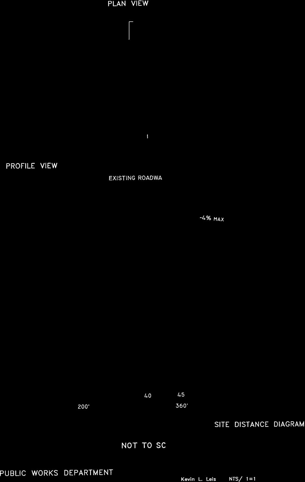
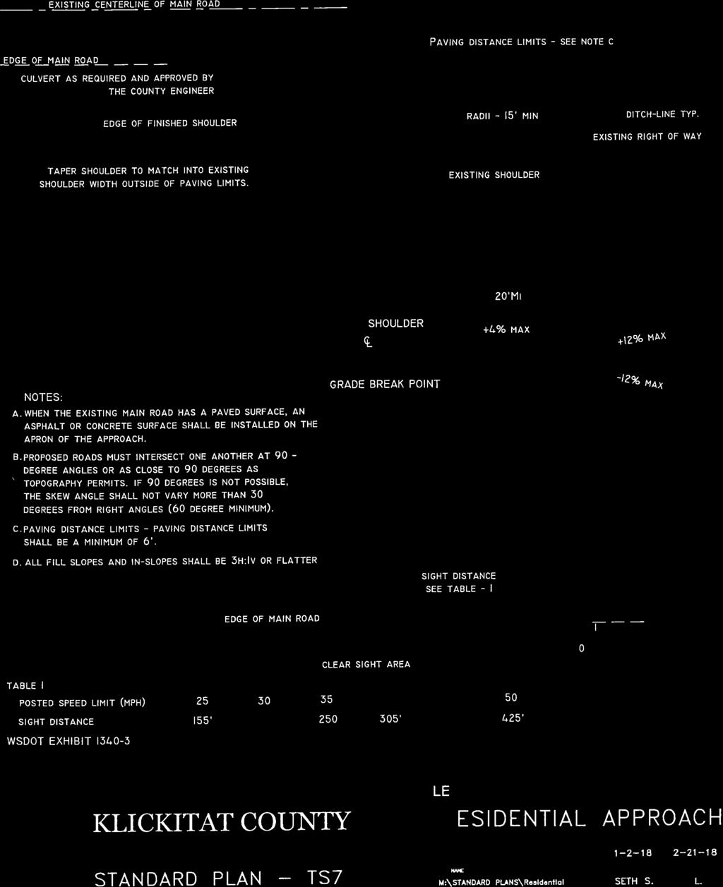
39
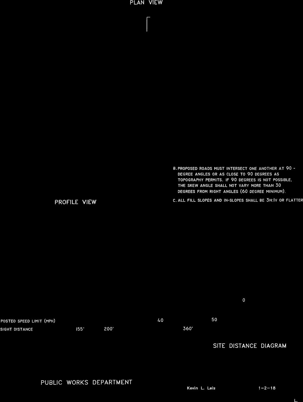
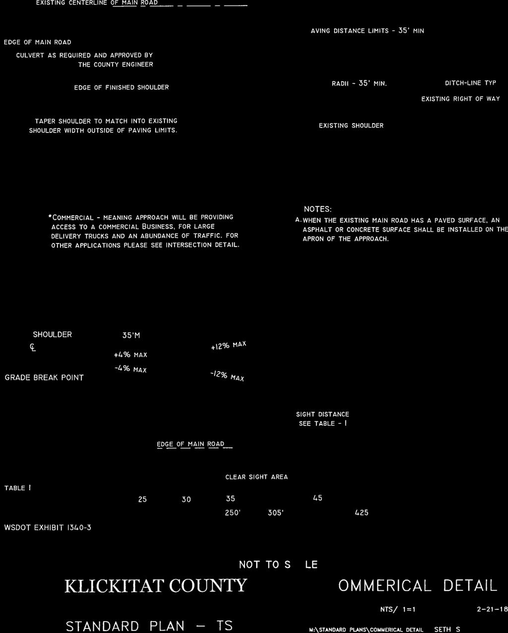
40
41 SIGN STANDARD Note: Put Road Name on Both Sides of Sign 6" Green Background White 4" Letters Public Street or Road Name Sign STANDARD DRAWING TS-9 Note: Put Road Name on Both Sides of Sign 6" Blue Background White 4" Letters White 2" Letters Private Street or Road Name Sign STANDARD DRAWING TS-10
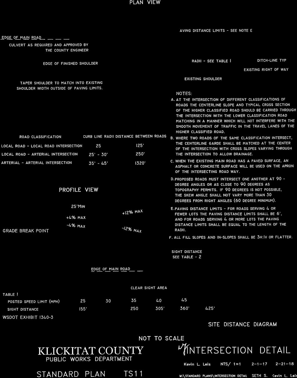
42