Background First Ten Years
|
|
|
- Agnes Page
- 5 years ago
- Views:
Transcription

1 Bob Keough Bucks County GIS Coordinator Background First Ten Years Legacy network model developed in 1992 Unix workstation Workstation ArcInfo 4.0 and AML ArcPlot Network Analyst extension Operational from Did not support real world network conditions Difficult to integrate with CAD system Output manually inputted (24,000 lines) Dynamap Centerline File Villanova University 1
2 Road Centerline Enhancements Support vehicle routing Segments oriented in direction of increasing address ranges Extend centerlines to squads outside of county Assign roadway type classifications Assign speed limits to each line segment Add one way travel direction impedances Add elevation values to represent over/underpasses Challenges Need accurate GIS representation of EMS Block boundaries as stored in the CAD System to enable GIS modeling of EMS Squad dispatch order o Reconcile CAD geofile and road centerline datasets to map geofile EMS Blocks to GIS road centerlines o Compile EMS block boundaries using geofile mapping of EMS Blocks on centerlines o Complete pilot project area for three townships o Validate feasibility of approach Villanova University 2
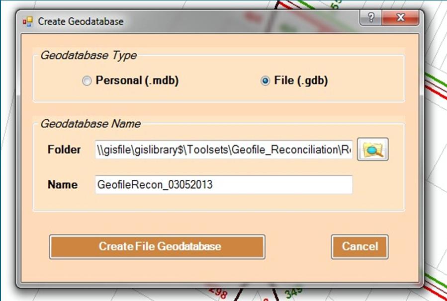
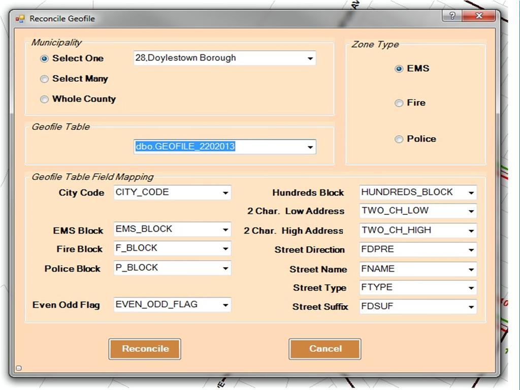
3 Geofile Reconciliation GeographIT developed a software tool to reconcile and map CAD geofile to GIS road centerlines Tool maps a geofile record to the road centerline by matching on road name and address ranges County GIS Tech s used the tool to reconcile and map CAD geofile to GIS road centerlines Run the tool Phase One Bucks County Review all unmatched geofile records and edit either the geofile or road centerline to achieve a match o Coordinated decisions needed to determine the correct road name spelling or address range Rerun the Reconciliation tool to ensure the edited CAD geofile or GIS road centerline results in a match Complete cycle until all geofile and road centerlines are matched Villanova University 3
4 Villanova University 4
5 Geofile Mapping Example Use the Phase One results Phase Two GeographIT o Road centerline consisting of EMS Blocks numbers mapped to each side of a road centerline Create EMS Block polygon features covering entire pilot area Create EMS Block destination nodes for each digitized EMS block o These are used in GIS to calculate average EMS Squad travel times to each EMS Block Villanova University 5

6 Phase Two Process GeographIT Digitize EMS Block polygons o Use EMS Block IDs that were mapped to the centerlines by the Reconcile tool o Review the geofile record to determine whether intersection is included o Extend polygons to interior areas using natural and cultural features to form interior boundaries. Place QA/QC points to highlight where data in the geofile or road centerline require cleanup Phase Two Results For the three municipalities in the pilot project area: o 79 EMS Blocks digitized using 4,811 geofile segments created by tool o 293 EMS Block destination nodes placed o 782 QA/QC Observation points created Villanova University 6
7 QAQC Observations Locations where inconsistencies were observed o Overlapping block records o Disconnected block parts o Descriptions in report Matched geofile records do not necessarily result in correct placement along a road centerline o Incorrect address range assignments could map the EMS Block at an incorrect location of the road centerline o Need to review each QAQC point o Correct road centerline and/or geofile to reflect correct road name or address range Phase Three Suite of tools for modeling Emergency Management System (EMS) dispatch orders Allows opportunity to create numerous scenarios by including (or not including): o Squad locations o Block boundaries Potential scenarios include: o New roads are added o Block boundaries/node locations change o Squads are added or removed 14 Villanova University 7
8 EMS Dispatch Modeling Toolbar Select Configuration File Help Documentation Add EMS Block Node Set Scenario Location Update OD Matrix Update OD Matrix Create Report Create CAD Dispatch Order File Create Scenario Model 15 Block Dispatch Maps Five (5) maps are available to spatially view data from a scenario Create Scenario tool can be run on the whole county or on specific entities Maps are produced based on the scenario that is run Some of the mapped data include: o Fastest response times for first ranked responders o Standard deviations for response times o EMS Block overviews o Squad boundaries for first ranked responders Each map is exported as PDF format for easy viewing, printing, and saving Map is shown in layout view of MXD o Identify features o Change colors o Change labels o Change scale 16 Villanova University 8
9 First Map EMS Block by Fastest Response Time for First Ranked Dispatch Location Shows EMS blocks symbolized by response time for topranked EMS dispatch location Green is the fastest, and red is the slowest 17 Second Map Standard Deviation of EMS Blocks Based on Fastest Response Time Represents EMS blocks symbolized by standard deviation from the mean for the average response time of the first responder For normal distribution, any value + or 2 standard deviations above/below the mean is considered statistically significant; exceeds 95% confidence interval for observed values 18 Villanova University 9

10 Third Map EMS Squad Boundaries of First Ranked Primary Responders Shows a boundary for a particular squad of the first ranked responders Theoretical boundaries show where the same squad is the first due responder for each block 19 Fourth Map EMS Block Variability by Average Rank Difference EMS blocks color coded by average rank difference o o Highlights the degree of variability for dispatch order of first 5 EMS squads assigned to each node in each block No variability means all nodes in a block are assigned with same dispatch order High variability means all nodes have different squad dispatch orders In this case, red is high, green is low Goal: reduce variability 20 Villanova University 10


11 Fifth Map EMS Block Overview Can only choose one block to display Shows selected block and related destination nodes Destination nodes labeled with: o Node ID o Fastest squad for that node o Response time in seconds 21 First Report EMS Block Overview Lists the 5 fastest EMS squads for the selected block and average time in minutes Lists the top 5 squads per destination node and their average response times in minutes 22 Villanova University 11


12 Second Report Standard Deviation of EMS Blocks for Fastest Average Response Time Histogram includes o Average response time of scenario blocks o Frequency of response time Also displays standard deviation above and below the mean response time 23 Third Report Index of Dispatch Variability per EMS Block Lists index of dispatch variability per EMS block in the current scenario Includes average rank difference and average response time difference 24 Villanova University 12

13 Fourth Report EMS Block Dispatch Order and Response Time Top 30 fastest EMS squads for the selected EMS block Includes squad ID, squad type, and average response time in minutes 25 Tool Datasets EMS Blocks o Polygon boundary representations o Drawn according to address ranges EMS Block Nodes o Node locations used as destination for response time calculations» Located mid block at key intersections» Should be equally spaced throughout the block EMS Locations o Point representations of dispatch locations o Used as the origin points for response time calculations o Point located at exit along road 26 Villanova University 13
14 Tool Definitions Select Configuration File o Navigate to the location of the configuration file when tools are used for the first time Add EMS Block Node o Adds an EMS block node to the block node feature class during an edit session Set Scenario Location o First tool to run to set up personal/file geodatabase and MXD for model processing Update OD Matrix o Creates an origin destination (OD) matrix that produces travel times from each origin (EMS squad location) to every destination (EMS block nodes) 27 Tool Definitions cont. Create Scenario Model o Uses OD matrix to produce model summaries based on user selected EMS squads and EMS blocks o 4 different summaries are created:» Fastest 30 EMS squads for each EMS block» Dispatch order variability index for destination nodes» Fastest 5 EMS squads for each destination node» Fastest 5 EMS squads for each EMS block based on average of all destination nodes Create Map o Creates map based on summary tables from Create Scenario Model tool and the squads and blocks chosen in the summaries o 5 different map options:» EMS Block by Fastest Response Time for First Ranked Dispatch Location» Standard Deviation of EMS Blocks Based on Fastest Response Time» EMS Squad Boundaries of First Ranked Primary Responders» EMS Block Variability by Average Rank Difference» EMS Block Overview 28 Villanova University 14
15 Tool Definitions cont. Create Report o Creates reports based on tables generated from the Create Scenario Model tool and the squads and blocks chosen o 4 different reports:» EMS Block Overview» Standard Deviation of EMS Blocks Based on Fastest Response Time» Index of Dispatch Variability per EMS Block» EMS Block Dispatch Order and Response Time Create CAD Dispatch Order File o Creates an ASCII file containing the dispatch order of the 30 fastest EMS squads for each selected EMS block in the county 29 Road Centerline and EMS Block Maintenance Formalized workflows in place Roles Responsibilities Processes Tools County Departments Board of Assessment Emergency Communications Emergency Health Services Planning Department Villanova University 15
16 Additional maintenance tools EMS Squad Dispatch Order ASCII File Loader Emergency Communications Viewer Final Analysis was it worth it? Integrated different types of data Improved accuracy of information Accelerated understanding of situations Increased the intrinsic value of all information Created actionable intelligence Automated procedures and workflows Centralized data sources Villanova University 16

17 Questions Villanova University 17
Esri Roads and Highways An Introduction. Nathan Easley Rahul Rakshit
 Esri Roads and Highways An Introduction Nathan Easley Rahul Rakshit Roads and Highways Linear Referencing for the Transportation Enterprise GIS-enabled LRS platform LRS management LRS editing & maintenance
Pasco County. Stormwater Inventory Master Plan
 Pasco County Stormwater Inventory Master Plan Introductions Derek Robinson GIS Analyst Pasco County Matt Terella Project Manager Jones Edmunds Brian Rosenfeld SR GIS Analyst Jones Edmunds Why did we need
One Maryland One Centerline. GIS-T 2014 May 7, 2014
 One Maryland One Centerline GIS-T 2014 May 7, 2014 Current Road Centerlines in Maryland SHA maintains a statewide centerline Supports HPMS program Represents state and local roads Capturing dual carriageways
A GIS Database for Warehouse Operations. A Project for Geography 575 Anderson Folts and Melelani Sax-Barnett
 A GIS Database for Warehouse Operations A Project for Geography 575 Anderson Folts and Melelani Sax-Barnett Outline Background Design objectives Data Applications Product distribution Routing Limitations
Esri Roads and Highways An Introduction
 Esri International User Conference San Diego, California Technical Workshops July 24, 2012 Esri Roads and Highways An Introduction William Isley Majunu Seran Agenda Product Overview Desktop - Demo: Network
Esri Defense Mapping for Server: Defense Product On Demand. Jeremiah Moore G.C. Rice
 Esri Defense Mapping for Server: Defense Product On Demand Jeremiah Moore G.C. Rice Overview Esri Defense Mapping Esri Defense Mapping Produce, Manage, and Share Authoritative Content System of Engagement
All Roads Do Not End at the State Line: Methodologies for Enabling Geodata Sharing Across Boundaries
 All Roads Do Not End at the State Line: Methodologies for Enabling Geodata Sharing Across Boundaries presented to 22 nd Geospatial Information Systems for Transportation Symposium presented by Julie Chizmas,
ArcGIS Extensions: Tools for Improving Data and Map Production. Sherry Fagin & Amber Bethell
 ArcGIS Extensions: Tools for Improving Data and Map Production Sherry Fagin & Amber Bethell Production Assembly Line Production Produce a flashy sports car Without Standards Production Produce a flashy
Presented by John Hudler Geospatial Group Leader Office of Transportation Data Georgia Department of Transportation
 Presented by John Hudler Geospatial Group Leader Office of Transportation Data Georgia Department of Transportation Collection, Quality Assurance and Reporting of the States roadway and transportation
Automated Access Planning On Construction Sites: An Expert GIS Approach
 Automation and Rohohcs un onstructlon A G.H. Watson, R.L. Tucker and J.K. Walters (Editors) 1993 Elsevier Science Publishers B.V. All rights reserved. 325 Automated Access Planning On Construction Sites:
Urban Planning Best Practices utilizing Spatial Services at Abu Dhabi
 Urban Planning Best Practices utilizing Spatial Services at Abu Dhabi Spatial Department Planning and Infrastructure Sector Abu Dhabi Urban Planning Council Agenda UPC-GIS Strategic Initiatives 2016-2020
Achieving Location Accuracy in GIS. John Adams, GISP Orleans Parish Communication District 2015 Louisiana Remote Sensing & GIS Workshop
 Achieving Location Accuracy in 9-1-1 GIS John Adams, GISP Orleans Parish Communication District 2015 Louisiana Remote Sensing & GIS Workshop given any reasonable input into the 9-1-1 Computer Aided Dispatch
ArcGIS for Land Records
 Virginia Association of Assessing Officers 63 rd Annual Conference October, 2011 ArcGIS for Land Records Arthur Robinson, Solution Engineer Bob Rike, Account Executive ArcGIS is a System A Complete System
Producing GEOINT with Esri Defense Mapping
 Federal GIS Conference February 9 10, 2015 Washington, DC Producing GEOINT with Esri Defense Mapping Heather Murnane & Brian Demers Presentation Agenda Introduction Create Content Manage Production Share
Roadway Data Extraction Technical Assistance Program (RDETAP) Traffic Safety Conference College Station, June 2016
 Traffic Safety Conference College Station, June 2016") Roadway Data Extraction Technical Assistance Program (RDETAP) Traffic Safety Conference College Station, June 2016 Overview Project motivation and objectives MIRE-MIS Program RDETAP Project Overview of
Roadway Data Extraction Technical Assistance Program (RDETAP) Traffic Safety Conference College Station, June 2016 Overview Project motivation and objectives MIRE-MIS Program RDETAP Project Overview of
GIS Technologies for Public Safety CHRIS HARVEY
 GIS Technologies for Public Safety CHRIS HARVEY Outline Identifying Needs Analysis Optimization of Services Communication and Public Outreach Accreditation GIS Solutions Desktop techniques Esri platforms
Development of A Statewide Crash Map: Merging and Mapping State and Nonstate Crashes Onto a Single Network
 Development of A Statewide Crash Map: Merging and Mapping State and Nonstate Crashes Onto a Single Network 2011 GIS-T Symposium Hershey, PA Tuesday, March 29, 2011 Andrew Graettinger, Ph.D. University
An Esri White Paper October 2010 Esri Production Mapping: Meeting the Needs of Water and Wastewater Utilities
 An Esri White Paper October 2010 Esri Production Mapping: Meeting the Needs of Water and Wastewater Utilities Esri, 380 New York St., Redlands, CA 92373-8100 USA TEL 909-793-2853 FAX 909-793-5953 E-MAIL
ArcGIS Workflow Manager Advanced Workflows and Concepts
 2013 Esri International User Conference July 8 12, 2013 San Diego, California Technical Workshop ArcGIS Workflow Manager Advanced Workflows and Concepts Kevin Bedel Nishi Mishra Esri UC2013. Technical
Best Practices for Utility Management. Presented by Steve Osiecki, GISP
 Best Practices for Utility Management Presented by Steve Osiecki, GISP Agenda Data management for utilities Developing harmonized CAD/GIS environment Importance of a good database structure Tools for implementation
GEOGRAPHIC INFORMATION SYSTEMS ADMINISTRATOR
 CITY OF REDLANDS GEOGRAPHIC INFORMATION SYSTEMS ADMINISTRATOR DEFINITION Under direction, to develop, program, and implement the City's Geographic Information System (GIS); to organize, coordinate, maintain,
ArcGIS Network Analysis Solving transportation problems
 Route Closest Facility Service Area ArcGIS Network Analysis Solving transportation problems Location-Allocation Vehicle Routing Problem Origin-Destination Cost Matrix Where do you get street data? Included
ArcGIS Extensions: Tools for Improving Data and Map Production. Amber Bethell & Sean Granata
 ArcGIS Extensions: Tools for Improving Data and Map Production Amber Bethell & Sean Granata No Standards With Standards Data and Map Production Productivity Cartography Efficiency Automation Accuracy Standardization
NHI Course Managing Traffic Incidents and Roadway Emergencies Module #4. Incident Response Procedures for Multi-Agencies 4-1
 NHI Course 133048 Managing Traffic Incidents and Roadway Emergencies Module #4 Incident Response Procedures for Multi-Agencies 4-1 Learning Objectives Define traffic incident response Explain the importance
Roadway Data Extraction Technical Assistance Program (RDETAP)
") Roadway Data Extraction Technical Assistance Program (RDETAP) 41 st International Forum on Traffic Records and Highway Information Systems October 2015 Overview Project motivation and objectives MIRE MIS
Roadway Data Extraction Technical Assistance Program (RDETAP) 41 st International Forum on Traffic Records and Highway Information Systems October 2015 Overview Project motivation and objectives MIRE MIS
Synchronize Our Modified Data with the Latest Vendor Update By Charline Avey IT Operations Support Lead. Abstract. Background
 Synchronize Our Modified Data with the Latest Vendor Update By Charline Avey IT Operations Support Lead Abstract The ability of Veolia Water Indianapolis to generate routes from destination addresses relies
Business Process Automation and GIS: The Art of Doing More
 Business Process Automation and GIS: The Art of Doing More Daniel Thomas Tallahassee Leon County GIS Tallahassee, Florida SO, WHAT IS IT YOU WOULD SAY YOU DO HERE? Thoughts From The Art of War Strategy
ArcGIS Data Reviewer An Introduction
 Esri International User Conference San Diego, California Technical Workshops July 26, 2012 ArcGIS Data Reviewer An Introduction Jay Cary & Michelle Johnson Workshop Overview Importance of Data Quality
Purchasing Department 102 South Hickory Avenue Bel Air, MD REQUEST FOR INFORMATION RFI #
 Purchasing Department 102 South Hickory Avenue Bel Air, MD 21014 410.809.6040 REQUEST FOR INFORMATION RFI # 08-07002 Transportation Routing and Attendance Area Planning Software Introduction: Harford County
AASHTO Transportation Safety Information Management System (TSIMS) Phase 1 Summary
 Phase 1 Summary") AASHTO Transportation Safety Information Management System (TSIMS) Phase 1 Summary Presented by: Hank Mycko Litton PRC, Manager of TSIMS System Architecture & Design TSIMS Goals Create a nationally recognized
AASHTO Transportation Safety Information Management System (TSIMS) Phase 1 Summary Presented by: Hank Mycko Litton PRC, Manager of TSIMS System Architecture & Design TSIMS Goals Create a nationally recognized
GIS & Next Generation What it all means AMY ROSE GIS ANALYST II, NCTCOG KASEY COX GIS TECHNICIAN II, NCTCOG
 GIS & Next Generation 9 1 1 What it all means AMY ROSE 9 1 1 GIS ANALYST II, NCTCOG KASEY COX 9 1 1 GIS TECHNICIAN II, NCTCOG Acronyms & Definitions ALI Automatic Location Identification ANI Automatic
Wayfinding with Directional Signs and Evacuation Maps
 Wayfinding with Directional Signs and Evacuation Maps Egress route diagrams are required by law as set forth by the authority having jurisdiction. Posting is the responsibility of the Building Coordinator
The Data Difference in
 The Data Difference in Next Generation 9-1-1 Systems A white paper from FE/Kimball May 2010 Page 2 Key terminology: GIS - geographic information system ALI - automatic location identification MSAG - master
Deploying Mobile Solutions Agenda. Quick Overview on Strategy Walk thru of Mobile Apps Deploying Mobile Apps
 Deploying Mobile Solutions Agenda Quick Overview on Strategy Walk thru of Mobile Apps Deploying Mobile Apps ArcGIS Apps Making mapping and location aware apps available across your organization Knowledge
Leveraging GIS to Improve Operations and Asset Management Lifecycle
 Leveraging GIS to Improve Operations and Asset Management Lifecycle Gabriel Borroni Joel Gladfelter ESRI AEC Summit 2014 San Diego, CA Asset Management Inventory Control Maintenance Management Scheduling/
Real-time customer information data quality and location based service determination implementation best practices.
 White paper Location Intelligence Location and Business Data Real-time customer information data quality and location based service determination implementation best practices. Page 2 Real-time customer
ArcGIS Workflow Manager: Advanced Topics. Kevin Bedel & Nishi Mishra
 ArcGIS Workflow Manager: Advanced Topics Kevin Bedel & Nishi Mishra Session Topics Overview Configure & Design Notify & Relate Integrate & Analyze Overview What is ArcGIS Workflow Manager? Configure &
OPEN DATA & PROJECT TRACKER. Michael Chamberlain TPP, Data Management
 OPEN DATA & PROJECT TRACKER Michael Chamberlain TPP, Data Management October 11, 017 Table of contents 1 People 3 Attributes 4 3 Locations 5 4 Systems 6 5 Reports 7-8 6 Applications 8-13 7 Closing 14 Data
The Importance of Data Quality Within Your Organization. Sherry Fagin and Andy Ommen
 The Importance of Data Quality Within Your Organization Sherry Fagin and Andy Ommen Workshop Agenda Perspectives of Data Quality What is ArcGIS Data Reviewer? Quality Control Processes Reporting Data Quality
ArcGIS Workflow Manager: An Introduction
 ArcGIS Workflow Manager: An Introduction Tope Bello and Michael Broadbent Esri UC 2014 Technical Workshop Why are you here? Importance of standardizing GIS and non-gis workflows ArcGIS Workflow Manager
WORKLOAD SELECTION. Gaia Maselli
 WORKLOAD SELECTION Gaia Maselli maselli@di.uniroma1.it Prestazioni dei sistemi di rete 2 So far State the goals and define the system List services and possible outcomes Select metrics (procedure) Select
Detailed Report Activities & Tasks Jun 2 nd 2016 For CAGIS Policy Board
 Cincinnati Area Geographic Information System Detailed Report Activities & Tasks Jun 2 nd 2016 For CAGIS Policy Board CAGIS Administrator Raj Chundur Inaugural Cincinnati City Manager's Award for Excellence
An Investigation into the Vagaries of Local Addressing Issues
 Author: Albert Hill An Investigation into the Vagaries of Local Addressing Issues Abstract: County government uses addresses for a plethora of purposes, from issuing permits to E911 dispatch. Unfortunately
ELDIS Software. Police and Safety. creating safety by technology! Product information ELDIS
 ELDIS Software Police and Safety creating safety by technology! Product information ELDIS ELDIS police deployment recording ELDIS The safety expert in the police environment Increased safety thanks to
Outagamie County CAD and RMS RFP Attachment G CAD and RMS Technical Requirements Instructions Table of Contents
 Outagamie County CAD and RMS RFP Attachment G CAD and RMS Technical Requirements Instructions Table of Contents Dispatch Workstations (Desktops)...2 Non-Dispatch Workstations (Desktops)...2 Mobile Laptops...2
RIDOT S Statewide Roadway and Asset Data Collection Project
 RIDOT S Statewide Roadway and Asset Data Collection Project ESRI User Conference 2017 Rafiq Basaria, DTS; Daniel Behnke DTS, Shane White, RIDOT Accent image here Primary Image here What is MIRE? Recommended
Creating Master Data Sets Build it once, use it a bunch
 Creating Master Data Sets Build it once, use it a bunch David Blackstone Office of Technical Services Dan Casey Chief Business Development Officer What When Why How Who What When Master Data Set Why How
Feasibility Study for a Statewide Road Centerline Data Set
 Feasibility Study for a Statewide Road Centerline Data Set Larry Spraker Fountains Spatial Schenectady, NY Andrew Rowan Douglas M Schleifer NJOIT-OGIS Statement of Problem In 2006, the NJ Geospatial Forum
What's New in ArcGIS 9.1 Business Analyst
 What's New in ArcGIS 9.1 Business Analyst Last revised July 18, 2005 Contents Highlights 3 Welcome to ArcGIS 9.1 Business Analyst 4 Geoprocessing 5 New ArcToolbox Window 5 Using the Geoprocessing Framework
Geographic Information System (GIS) Transportation Technician II
 Transportation Technician II") Geographic Information System (GIS) Transportation Technician II Position Details Class Code: 6352 Job Family: Service/Transportation Workers Classification: Support Staff Terms of Employment: Pay Grade
Geographic Information System (GIS) Transportation Technician II Position Details Class Code: 6352 Job Family: Service/Transportation Workers Classification: Support Staff Terms of Employment: Pay Grade
NYC Citywide GIS. NYC Technology Forum. November 2, 2006
 NYC Citywide GIS NYC Technology Forum November 2, 2006 AGENDA Welcome/Introduction Marsha Kaunitz GeoDataShare Mario Gouvea CityMap Mario Gouvea Citywide Street Centerline Project Colin Reilly Addressing
Accurate Mapping Probe TM
 Accurate Mapping Probe TM The CUES Accurate Mapping Probe is the most accurate gyroscopic tool for mapping the XYZ positions of underground utilities produced today. The AMP TM can be provided via the
Run Orders. Modeling and mapping public safety arrival orders
 Run Orders Modeling and mapping public safety arrival orders 40 ArcUser Fall 2009 Hands On What You Will Need ArcGIS Desktop (ArcView, ArcEditor, or ArcInfo license) ArcGIS Network Analyst extension Sample
Accelerated Sign Inventory and Management
 2015 The AASHTO Subcommittee on Maintenance (SCOM), Des Moines, Iowa Accelerated Sign Inventory and Management Erany Robinson-Perry Assistant State Maintenance Engineer Georgia Department of Transportation
EXECUTIVE SUMMARY / BRIEF OVERVIEW
 EXECUTIVE SUMMARY / BRIEF OVERVIEW Roanoke County s Public Safety departments desired an application to replace a paper map-focused incident command system to one which could be easily deployed from any
Project Title: Using Truck GPS Data for Freight Performance Analysis in the Twin Cities Metro Area Prepared by: Chen-Fu Liao (PI) Task Due: 12/31/2013
 Task Due: 12/31/2013") Project Title: Using Truck GPS Data for Freight Performance Analysis in the Twin Cities Metro Area Prepared by: Chen-Fu Liao (PI) Task Due: 12/31/2013 TASK #5: IDENTIFY FREIGHT NODE, FREIGHT SIGNIFICANT
Project Title: Using Truck GPS Data for Freight Performance Analysis in the Twin Cities Metro Area Prepared by: Chen-Fu Liao (PI) Task Due: 12/31/2013 TASK #5: IDENTIFY FREIGHT NODE, FREIGHT SIGNIFICANT
Great River Energy GIS. John Auel United Services Group
 Great River Energy GIS John Auel United Services Group Background Bachelor of Science at the University of Wisconsin, Steven s Point Area of Emphasis Cartography Currently employed at United Services Group
Esri Production Mapping An Introduction
 2013 Esri International User Conference July 8 12, 2013 San Diego, California Technical Workshop Esri Production Mapping An Introduction Amber Bethell Sean Granata Esri UC2013. Technical Workshop. Workshop
WindMil Map ESRI Combining Engineering Analysis with GIS. Doug Lambert SCADA and Engineering Data Supervisor
 WindMil Map ESRI Combining Engineering Analysis with GIS Doug Lambert SCADA and Engineering Data Supervisor Overview The idea of keeping our engineering analysis model, GIS data, and our outage management
reviewed paper Integrated Transportation Planning and Information with PTV Vision Technology Thomas FRIDERICH
 reviewed paper Integrated Transportation Planning and Information with PTV Vision Technology Thomas FRIDERICH 1 INTRODUCTION (Dipl. Tech. Math. Thomas Friderich, PTV AG, Stumpfstr. 1, 76131 Karlsruhe,
Agricultural Trip Generation - Linking Spatial Data and Travel Demand Modeling using SAS
 MWSUG 2017 Paper AA18 Agricultural Trip Generation - Linking Spatial Data and Travel Demand Modeling using SAS Alan Dybing, North Dakota State University UGPTI, Fargo, ND ABSTRACT Data linkages from GIS
Assembling MIRE Data. The Vermont Experience. Vermont Agency of Transportation (VTrans) Mapping Section
 Mapping Section") Assembling MIRE Data The Vermont Experience A look into the development of GIS-based intersection data Vermont Agency of Transportation (VTrans) Mapping Section March 20, 2018 Embarking on the Task of
Assembling MIRE Data The Vermont Experience A look into the development of GIS-based intersection data Vermont Agency of Transportation (VTrans) Mapping Section March 20, 2018 Embarking on the Task of
Urban Traffic Data Integration: A Case Study for Edmonton
 Urban Traffic Data Integration: A Case Study for Edmonton Presenter: Dr. Tony Qiu, University of Alberta Co-authors: Md Tazul, Gary Liu, Michael Ge, University of Alberta Dr. Stevanus A. Tjandra, City
Colonial Pipeline Company - Managing Operational Risk
 Colonial Pipeline Company - Managing Operational Risk Topics Background information on Colonial Pipeline Departmental versus Enterprise GIS ArcGIS Pipeline Data Model (APDM) + Geodatabase as foundation
The Data Difference in
 The Data Difference in Next Generation 9-1-1 Systems A white paper from L.R. Kimball May 2010 866.375.6812 info@lrkimball.com www.lrkimball.com ARchitecture Engineering Communications technology aviation
How Freight Moves: Estimating Mileage and Routes Using an Innovative GIS Tool
 How Freight Moves: Estimating Mileage and Routes Using an Innovative GIS Tool Stephen M. Lewis Geospatial Information Officer United States Department of Transportation January 20, 2011 ESRI UC 2008 1
ArcGIS Workflow Manager: Effectively Managing Workflows within the ArcGIS Enterprise
 ArcGIS Workflow Manager: Effectively Managing Workflows within the ArcGIS Enterprise Elizabeth Wilcox and Bryan Piersol Guest Presenter: Ronnie Buzzard, United States Army Geospatial Center Our plan today
From data to display Data loading, quality control and workflow management
 From data to display Data loading, quality control and workflow management Kiyoshi Yamashita Kristen Waldvogel Esri Software Components Production Mapping Data Review Feature Manager Workflow Management
Creating a Transit Supply Index. Andrew Keller Regional Transportation Authority and University of Illinois at Chicago
 Creating a Transit Supply Index Andrew Keller Regional Transportation Authority and University of Illinois at Chicago Presented at Transport Chicago Conference June 1, 2012 Introduction This master's project
Data processing. In this project, researchers Henry Liu of the Department of Civil Engineering and
 Data mining of transit vehicle location, passenger count, and fare collection databases for intelligent transportation applications Supporting efficient transit service by maximizing the use of available
Comparisons of image- and plot-based estimates of number and size of forest patches in Michigan, USA
 Comparisons of image- and plot-based estimates of number and size of forest patches in Michigan, USA Mark D. Nelson 1, Dacia M. Meneguzzo 2, and Mark H. Hansen 3 1 U.S. Department of Agriculture, Forest
Robert Parsons GIS Director Delaware County Auditor s Office Travis Gregorich Bruce Harris & Associates Account Manager
 Improving Real Estate Appraisal and Assessment using ArcGIS Robert Parsons GIS Director Delaware County Auditor s Office Travis Gregorich Bruce Harris & Associates Account Manager Delaware County, Ohio
Groundwater Review Assistant (GWRA) User Guide
 User Guide") Groundwater Review Assistant (GWRA) User Guide Table of Contents 1. INTRODUCTION... 2 2. DISCLAIMER AND LIMITATIONS... 2 3. QUICK START GUIDE... 3 4. GROUNDWATER REVIEW ASSISTANT USER INFORMATION... 4
Groundwater Review Assistant (GWRA) User Guide Table of Contents 1. INTRODUCTION... 2 2. DISCLAIMER AND LIMITATIONS... 2 3. QUICK START GUIDE... 3 4. GROUNDWATER REVIEW ASSISTANT USER INFORMATION... 4
BASINS EXERCISE. 2) Select the Locate your Watershed webpage (located at:
 Select the Locate your Watershed webpage (located at:") BASINS EXERCISE Overview This exercise was created for the Fox-Wolf Watershed Alliance - Stormwater 2003 Conference. Funding was provided by the University of Wisconsin Sea Grant Institute and UW Land
BASINS EXERCISE Overview This exercise was created for the Fox-Wolf Watershed Alliance - Stormwater 2003 Conference. Funding was provided by the University of Wisconsin Sea Grant Institute and UW Land
Sage ERP MAS 90 and Intelligence Release Notes
 Sage ERP MAS 90 and 200 4.50 Intelligence Release Notes Table of Contents 1 New Reporting Trees... 2 1.1 Reporting Tree Example... 2 1.2 Reporting Trees... 2 1.3 Linking Reporting Tree Units to Distribution
CHAPTER 2 - TRAVEL DEMAND MODEL DEVELOPMENT
 CHAPTER 2 - TRAVEL DEMAND MODEL DEVELOPMENT 2.1 EXISTING TRAVEL DEMAND MODEL In order to accurately project future year traffic volumes within this regional study area, it was first necessary to construct
VISUM State-of-the-Art Travel Demand Modeling VISUM
 State-of-the-Art Travel Demand Modeling VISUM What is VISUM? VISUM is a comprehensive, flexible software system for transportation planning, travel demand modeling and network data management. VISUM is
GIS Centric Approach to Enterprise GIS HCG Case Study
 GIS Centric Approach to Enterprise GIS HCG Case Study GIS, as a part of local government has taken deep root globally. As systems mature beyond the point of creation and maintenance, a new evolution is
ArcGIS Workflow Manager Advanced Workflows and Concepts
 Esri International User Conference San Diego, California Technical Workshops July 26, 2012 ArcGIS Workflow Manager Advanced Workflows and Concepts Raghavendra Sunku Kevin Bedel Session Topics ArcGIS Workflow
Extending Linear Referencing System (LRS) capabilities to Pipeline organizations. Anjali Bhangay and Summer Hall
 capabilities to Pipeline organizations. Anjali Bhangay and Summer Hall") Extending Linear Referencing System (LRS) capabilities to Pipeline organizations Anjali Bhangay and Summer Hall Pipeline Referencing Functionalities and Capabilities Information Model Data Management Geoprocessing
Extending Linear Referencing System (LRS) capabilities to Pipeline organizations Anjali Bhangay and Summer Hall Pipeline Referencing Functionalities and Capabilities Information Model Data Management Geoprocessing
Upgrading The Tennessee DOT TRIMS Application To A New GIS Platform
 Upgrading The Tennessee DOT TRIMS Application To A New GIS Platform Presented by: Rick Hammond, GISP March 26, 2007 Project Steps Develop a T-DOT Migration Plan Did not recommend a TRIMS Replacement Does
Process to Identify High Priority Corridors for Access Management Near Large Urban Areas in Iowa Using Spatial Data
 Process to Identify High Priority Corridors for Access Management Near Large Urban Areas in Iowa Using Spatial Data David J. Plazak and Reginald R. Souleyrette Center for Transportation Research and Education
NJDOT: Asset Management Strategies and Tools
 NEW JERSEY DEPARTMENT OF TRANSPORTATION NJDOT: Asset Management Strategies and Tools Wednesday, October 1, 2014 Afternoon Session (1:45pm 2:30pm) Presenters Michael Castaldo New Jersey Department Of Transportation
Scheduling features for Simulation. Simio User Group /5/2018 Copyright 2017 Simio LLC 1
 Scheduling features for Simulation Simio User Group 2018 6/5/2018 Copyright 2017 Simio LLC 1 Simio Product Family Simio Design Edition Simio Team Edition Simio Enterprise Edition Simio Portal Simio Personal
Maximo v Feature Pack release. October 21, 2016
 Maximo v7.6.0.6 Feature Pack release October 21, 2016 Russ Anderton Cohesive Solutions, Vice President Lisa Stuckless IBM Offering & Strategy Manager Kim Woodbury IBM Offering & Strategy Manager Introduction
EMS, FIRE AND LAW SOFTWARE SOLUTION. MAKES RESPONDING FASTER AND EASIER
 Product Sheet emma CAD EMS, FIRE AND LAW SOFTWARE SOLUTION. MAKES RESPONDING FASTER AND EASIER emma is an emergency management platform based on complete suite of public safety applications, fully developed
ROCOG TRANSPORTATION PLANNING WORK PROGRAM
 ROCOG TRANSPORTATION PLANNING WORK PROGRAM 2018-2019 SEPTEMBER 2017 Preparation of this document is financed in part by the U.S. DOT as referenced in the ROCOG 2017 Transportation Work Program under Work
City of Tacoma TRANSPORTATION MASTER PLAN DRAFT
 City of Tacoma TRANSPORTATION MASTER PLAN 140 APPENDICES Appendix A Model Documentation MEMORANDUM Date: November 26, 2014 To: City of Tacoma, Department of Public Works From: Chris Breiland, Fehr & Peers
Oracle Field Service Cloud. What's New in the August 2016 Release
 Oracle Field Service Cloud What's New in the August 2016 Release August 2016 TABLE OF CONTENTS REVISION HISTORY... 3 OVERVIEW... 4 Security & New Features... 4 Give Us Feedback... 4 RELEASE FEATURE SUMMARY...
Sylvia Kendra Associate Director Facilities Knowledge Management. January 11, 2017
 Developing a 3D Building Information Management Practice Sylvia Kendra Associate Director Facilities Knowledge Management January 11, 2017 Find Us On Line Google search: Smithsonian AE Center Or Full url:
Machine Assisted Geodesign
 Machine Assisted Geodesign The Team Ervin Cable Construction 3-GIS Full service provider of construction, design, and engineering services to the telecommunications industry. Automated planning services
MEMORANDUM. Date: July 14, 2006 Project #: To: US 97 & US 20 Refinement Plan Steering Committee
 MEMORANDUM Date: July 14, 2006 Project #: 6389 To: US 97 & US 20 Refinement Plan Steering Committee From: Sonia Hennum, P.E., Andrew Cibor, E.I.T., & Julia Kuhn, P.E. Project: US 97 & US 20 Refinement
Austin Rohr Wichita KS
 Austin Rohr Wichita KS Justify the need for ALS services to be provided by the fire department by using GIS and statistical analysis How are both services currently performing? Providing ALS from both
Fire Station #8 Task Force. Aurora Hill Recreation Center February 4, 2016 from 7-9:30pm
 Fire Station #8 Task Force Aurora Hill Recreation Center February 4, 2016 from 7-9:30pm Agenda 7:00 7:05 7:05 7:40 7:40 8:45 Presentation Q&A 8:40 9:00 9:05 9:30 Welcome and Opening Comments Introduction
What s New in NX 12. NX Product Marketing Team October Restricted Siemens AG Realize innovation.
 What s New in NX 12 NX Product Marketing Team October 2017 Restricted Siemens AG 2017 Realize innovation. NX 12 for Product Design Remove the barriers to innovation Technological forces transforming industry
ENTERPRISE DREDGE (edredge): A DREDGING BUSINESS PRACTICE ENTERPRISE GIS APPLICATION
: A DREDGING BUSINESS PRACTICE ENTERPRISE GIS APPLICATION") ENTERPRISE DREDGE (edredge): A DREDGING BUSINESS PRACTICE ENTERPRISE GIS APPLICATION L.S. Lillycrop 1 and R. Dopsovic 2 ABSTRACT Implementation and management of US Army Corps of Engineers (USACE) dredging
ENTERPRISE DREDGE (edredge): A DREDGING BUSINESS PRACTICE ENTERPRISE GIS APPLICATION L.S. Lillycrop 1 and R. Dopsovic 2 ABSTRACT Implementation and management of US Army Corps of Engineers (USACE) dredging
Geospatial Considerations for Emergency Call-Taking, Computer-Aided Dispatch, and Record Management Systems
 Geospatial Considerations for Emergency Call-Taking, Computer-Aided Dispatch, and Record Management Systems An Esri White Paper January 2016 info@esri.com esri.com Copyright 2016 Esri All rights reserved.
A Network Demand Model for Rural Bypass Planning. Paper Number
 A Network Demand Model for Rural Bypass Planning Paper Number 00-1205 Dr. Michael D. Anderson Assistant Professor of Civil Engineering Department of Civil and Environmental Engineering The University of
Oakland County Department of Information Technology Project Scope and Approach
 Oakland County Department of Information Technology Project Scope and Approach Project Name: Facilities Safety Dispatch Management Project ID: D82147SD Leadership Group: Land Department: Facilities Management
MAP INTERFACE FOR IOWA DEPARTMENT OF TRANSPORTATION S ACCESS-ALAS
 MAP INTERFACE FOR IOWA DEPARTMENT OF TRANSPORTATION S ACCESS-ALAS Aravind Gottemukkula Center for transportation education and research Iowa State University ABSTRACT This paper discusses the limitations