Transportation Concurrency
|
|
|
- Earl Barton
- 5 years ago
- Views:
Transcription

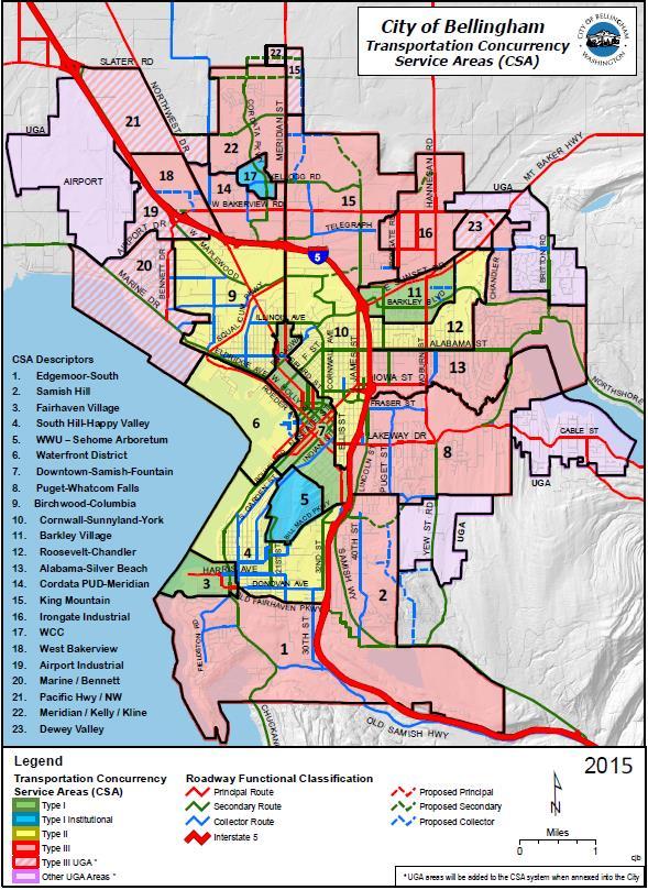
1 2017 Frequently Asked Questions About. Transportation Concurrency Q. What is Transportation Concurrency? A. Transportation Concurrency is both a State law requirement and a City pre-application development regulation used to ensure that adequate transportation infrastructure is in place at the time of new development approval or that the community has made adequate provisions to address transportation impacts from development. Transportation concurrency links our community s land use plans with our transportation and capital improvement plans, providing us with a tool for effectively managing the growth of our community. Bellingham s Multimodal Transportation Concurrency ordinance (BMC 13.70) is a requirement of the Washington State Growth Management Act (RCW 36.70A.070 (6) (b)). Q. What does Multimodal mean? A. Multimodal refers to the variety of transportation modes for people and goods to travel around Bellingham. Bellingham s Multimodal Transportation Concurrency program focuses on the four major modes of transportation available to the traveling public: pedestrian, bicycle, public transit, and automobile. Freight is also an important transportation mode, but is not considered a people-moving mode and is not included in the calculation of multimodal transportation concurrency. Q. How is Multimodal Transportation Concurrency Measured? A. There are 23 Concurrency Service Areas (CSAs) throughout the City limits of Bellingham (See Figure 2, below). Each year, Public Works conducts counts of automobile traffic volume at specific Concurrency Measurement Points (CMPs) on major arterial corridors within each CSA and measures the recorded volumes against the design capacity of the roadway. Traffic volumes are multiplied by national standards for average car occupancy rates to establish automobile person trips. The ratio of traffic volume to roadway capacity establishes a Level of Service (LOS) for each CMP. Whatcom Transit Authority (WTA), the regional public transit agency, also collects annual concurrency data for transit service. WTA establishes transit capacity for their fleet of busses based on the number of seats available, the frequency of each route, and annual ridership statistics collected through surveys and passenger counts at specific CMPs within each CSA. Public Works compares transit ridership to seated capacity to determine transit person trips and LOS for each CMP. Bicycle and pedestrian facilities are measured for degree of completeness rather than capacity measurements. Each year, Public Works measures the existing inventory of completed bicycle and pedestrian facilities on the ground within each CSA against the planned bicycle and pedestrian networks adopted in the Bellingham Comprehensive Plan. If the degree of completeness exceeds 50%, then person trip credits are awarded for each 1% above the 50% minimum. The goal is that, over time, the planned bicycle and pedestrian networks will be completed through both public and private investments. Research does show that the availability of safe and convenient bicycle and pedestrian facilities can lead to increases in people walking and bicycling, which is consistent with the mode shift goals adopted in the Transportation Element of the Bellingham Comprehensive Plan.
2 The automobile and transit capacity measurements are converted to person trips and combined with the degree of completeness and person trip credits for bicycle, pedestrian, and trail facilities to establish an overall measurement of Person Trips Available within each CSA. The process for measuring each of the four major transportation modes, as well as the overall calculation of Person Trips Available within each CSA is illustrated in the flow chart below. Define Concurrency Service Areas, Corridors, & Measurement Points Motorized Modes (Auto & Transit) Non-Motorized Facilities (Bicycle, Sidewalk, Trail) Collect Demand & Supply Data of Motorized Modes Collect Data of Existing & Planned Non-Motorized Facilities Calculate Available Person Trips for Auto & Transit Modes Calculate Credit Person Trips of Non-Motorized Facilities Calculate Concurrency Service Area Total Person Trips Available Draw Down Available Person Trips in each Impacted Concurrency Service Area for each Concurrency Application
3
4 Q. How Does Multimodal Transportation Concurrency Affect New Development? A. Before the City can accept an application for new development within a Concurrency Service Area, a determination must be made that there are enough Person Trips Available on the multimodal transportation network to serve the proposed development. If there are not enough Person Trips Available, then the developer would be required to fund and construct bicycle, pedestrian, transit, or automobile improvements to ensure adequate Person Trips Available. In short, if a proposed development is likely to exceed the number of Person Trips Available, the development cannot be approved. Q. Isn t Transportation Concurrency Supposed to Stop Growth? A. No. Unfortunately, there are quite a few misunderstandings about transportation concurrency. Specifically, concurrency is often misunderstood to be a way to stop both new development and new people from coming into our community. State law, the Washington Administrative Code (WAC) Concurrency (3) (b), specifically states Levels of service should be set to reflect realistic expectations consistent with the achievement of growth aims. Setting such levels too high could, under some regulatory strategies, result in no growth. As a deliberate policy, this would be contrary to the act. The Washington State Growth Management Act (GMA) requires cities and counties to find balance in achieving 14 major goal statements, some of which are in direct competition with one another. The GMA provides general framework legislation, but leaves the details up to cities and counties to balance competing interests while managing (not stopping) population growth. Transportation is only one of the 14 goal statements that must be attended to and transportation concurrency is simply one of the policy tools that local planners can use to help manage our community s growth in a responsible manner (See Figure 4, below). Q. Can We Continue to Allow Urban Infill Development With Rush Hour Traffic Congestion? A. You might remember that in 1993, Bellingham citizens created Visions for Bellingham, which called for a more densely populated urban community with infill development focused primarily in urban centers and a population reliant on walking, biking, and public transportation, rather than automobile-dominated suburbs spread out across the landscape of rural Whatcom County. These Visions for Bellingham became the adopted goals and policies for the 1995 Bellingham Comprehensive Plan and were re-iterated by Bellingham citizens throughout the 2004 Community Forum on Growth Management. The same Visions also provided the foundation for the 2006 Bellingham Comprehensive Plan to accommodate 31,600 new residents, which is half of Whatcom County s projected population growth of 62,000 new residents by Now we are faced with making this land use vision a reality, which will require that our elected decision-makers and, more importantly, we as a community, make some difficult and, possibly, unpopular choices about transportation policy that will be necessary to allow successful infill development to occur. It is important to realize that, with the exception of the rush hour commute, our multimodal transportation system works quite well (See next page). In other words, the transportation concurrency debate is all about our perception of convenience and the types of sacrifices we are willing to make during about one hour of our daily driving routine. Bellingham s vision of concentrated density and people living, shopping, and working in Urban Villages will not materialize, however, unless citizens are willing to change their expectations about rush hour automobile traffic congestion and their travel and mobility decisions and behavior.

5 Q. What are the Costs to City Taxpayers? A. When new public streets are constructed, everyone in Bellingham and Whatcom County has access to them. Public tax dollars will be used to pay for the public s share of whatever transportation concurrency solution is adopted. That s what the state law requires. This means that if we, as a community, decide to expand our arterial streets to provide for free-flow traffic during the local evening rush hour, then we should expect to pay higher taxes to support and maintain that choice. Wider streets in our urban core would mean more public right-of-way dedicated to asphalt and concrete impervious surfaces, more real estate purchases for storm water detention facilities, and changes to our urban environment, including possible purchase of yards, homes, or commercial buildings for additional right-of-way. Wider streets would also require that more public tax dollars be dedicated for street maintenance and repair, but in the long-run would not reduce peak hour traffic congestion. The end result would simply be wider streets, constructed at great public cost, that are not heavily used during non-peak hours. The cost of wider streets is not measured in dollars alone, however. Wider streets make pedestrian crossings much more challenging, especially for school children, physicallychallenged individuals, and senior citizens. Wider streets would change the look and feel of our neighborhood areas and would make the already limited urban land supply less available for infill development. Constructing wider streets would simply continue to enable the dominance of the private automobile in our urban environment. Q: Why can t developers pay for all these costs? A: Developers pay significant fees for traffic impacts caused by their new residential, commercial, and industrial projects. For instance, developers are required to meet City street standards, SEPA mitigation review for traffic safety impacts, Traffic Impact Fee (TIF) charges, and Multimodal Transportation Concurrency evaluation. This results in street improvements, new traffic signals, sidewalks, bicycle lanes, curbs, gutters, storm water detention facilities, etc. to ensure that the traffic generated by new development will not overburden Bellingham s transportation system. Everyone contributes to the growth of our community and everyone contributes to traffic congestion every time they drive an automobile. There is a public share for new transportation facilities because everyone will use and benefit from them, not just the new residents of the development project.

6 Q: Won t more traffic congestion just delay emergency vehicle response? A: Police, fire, and emergency medical vehicles constantly face the challenges of getting through traffic on the way to their destinations. Their drivers are trained to be able to avoid congestion, first, by route selection, but, more importantly, by evasive measures. In addition, every City Police, Fire, or EMS vehicle is equipped with a device to pre-empt traffic signals and change the light to green to allow the emergency vehicle to pass through with minimal delay, even when there is significant traffic congestion. It is also important to remember that the worst traffic congestion usually only occurs during the rush hour. An urban level of service is unlikely to adversely impact service delivery. The Police and Fire Departments will continue to work with City Public Works and Planning staff during the project review process to change and adjust service to community developments. City of Bellingham Web Site Resources Transportation Concurrency applications are available on the City of Bellingham web site at: Public Works Transportation Planning Staff Public Works staff are responsible for the implementation of the Transportation Concurrency Management Program and can be reached by telephone or by between 8:00am and 5:00pm, Monday through Friday, as listed below. Chris Comeau, AICP, Transportation Planner (360) ccomeau@cob.org Brent Baldwin, AICP, Development Review Manager (360) bbaldwin@cob.org