Chapter 7 Transport. Appendix A to Legal Submissions. Council's Revised Stage 2 Proposal (marked up) 1 September 2015 version
|
|
|
- Neil Robbins
- 5 years ago
- Views:
Transcription
1 Chapter 7 Transport Key: In this Revised Proposal Appendix A to Legal Submissions Stage 1 provisions are shown in grey text; and Stage 2 provisions are shown in black text. The Stage 1 text is as per the Hearing Panel's Stage 1 decision. Note that only the relevant Stage 1 provisions have been included in this Revised Proposal. 1 September 2015 version: The Stage 2 text was amended in response to submissions, and those amendments are showing in black underlined text (for additions) and black strike through text (for deletions). The Stage 2 submission providing scope for the change is noted in square brackets beside the relevant change. KiwiRail Amendments in Hewett evidence: amendments are showing in red underlined text (for additions). Council Amendments in Mr Falconer's evidence (where accepted by KiwiRail) are showing in bold green underlined text (for additions) and green strikethrough text for (deletions). Amendments from Mr Falconer's rebuttal not accepted by KiwiRail are showing in red underlined and strike through text. For completeness, text underlined in green (but not bold) indicates that the word is a defined term. Text underlined in blue is a hyperlink. 1
2 Chapter 7 Transport Contents 7.1 Objectives and policies Objective 1 Integrated transport system for Christchurch District Objective 2 - Adverse effects from the transport network 7.2 Rules All zones outside the Central City How to use the rules Activity Status Tables All zones outside of the Central City Rules - All zones outside the Central City 7.3 Matters of Control and Discretion Minimum number of car parks required Parking space dimensions Mobility parking spaces Minimum number of cycle parking facilities required Minimum number of loading spaces required Manoeuvring for parking and loading areas Gradient of parking and loading areas Illumination of parking and loading areas Surface of parking and loading areas Vehicle access design Queuing spaces Visibility splay Vehicle crossing design Minimum distance between vehicle crossings Maximum number of vehicle crossings Minimum distance between vehicle crossings and intersections Sight lines at vehicle crossings Location of buildings and access in relation to road/rail level crossings High trip generators Transport Infrastructure in the transport zone Formation of unformed legal roads Appendices Appendix 7.1 Parking space requirements Appendix 7.2 Cycle parking facilities Appendix 7.3 Loading areas Appendix percentile design motor car Appendix percentile design vehicle Appendix 7.6 Manoeuvring for parking and loading areas Appendix 7.7 Access design Appendix 7.8 Queuing spaces Appendix 7.9 Visibility splay 2
3 Appendix 7.10 Design of rural vehicle crossings Appendix 7.11 Standards for the location of vehicle crossings Appendix 7.12 Road classification system Appendix 7.13 Building setbacks to level crossings Appendix 7.14 Parking reduction adjustment factors 3
4 7.1 Objectives and policies Objective 1 Integrated transport system for Christchurch District a. An integrated transport system for Christchurch District: i. that is safe and efficient for all transport modes; ii. that is responsive to the current recovery needs, future needs, and enables economic development; iii. that supports safe, healthy and liveable communities by maximising integration with land use; iv. that reduces dependency on private motor vehicles and promotes the use of public and active transport; v. that is managed using the one network approach Policy 1 Establishment of a road classification system a. Identify a road network that connects people and places and recognises different access and movement functions for all people and transport modes, whilst: i. supporting the safe and efficient operation of the transport network; ii. providing for public places in accordance with the function of the road to enable community activities including opportunities for people to interact and spend time, iii. providing space for utility services; iv. reflecting neighbourhood identity and amenity; v. recognising cross-boundary connections with adjoining districts, and vi. providing for the efficient and effective functioning of the strategic transport network, including for freight. Refer to Appendix 7.12 for a description of the road classification system. Policy 1 also achieves Objective Policy 2 High trip generating activities Manage the adverse effects of high trip generating activities on the transport system by assessing their location and design with regard to the extent that they: a. are permitted 1 by the zone in which they are located; b. are located in urban areas and generate additional vehicle trips beyond what is already established or consented; 1 refers to the activity being listed as a permitted activity in the activity status table for the zone in which it is located. 4
5 c. are accessible by a range of transport modes and encourage public and active transport use; d. do not compromise the safe, efficient and effective use of the transport system; e. provide patterns of development that optimise use of the existing transport system; f. i. maximise positive transport effects; ii. avoid significant adverse transport effects of activities where they are not permitted by the zone in which they are located; and iii. mitigate other adverse transport effects, such as effects on communities, and the amenity of the surrounding environment, including through travel demand management measures; g. provide for the transport needs of people whose mobility is restricted; and h. integrate and coordinate with the transport system, including proposed transport infrastructure and service improvements. Policy 2 also achieves Objective Policy 3 Vehicle access and manoeuvring Provide vehicle access and manoeuvring, including for emergency service vehicles, compatible with the road classification, which ensures safety, and the efficiency of the transport system. Policy 3 also achieves Objective Policy 4 Requirements for car parking and loading a. Require car parking and loading spaces which provide for the expected needs of an activity in a way that manages adverse effects. b. Enable a reduction in the number of car parking spaces required in circumstances where it can be demonstrated that: i. the function of the surrounding transport network and amenity of the surrounding environment will not be adversely affected; and/or ii. there is good accessibility by active and public transport and the activity is designed to encourage public and active transport use; and /or iii. the extent of the reduction is appropriate to the characteristics of the activity and its location; and/or iv.. the extent of the reduction will maintain onsite parking to meet anticipated demand. Policy 4 also achieves Objective 2. 5
6 Policy 5 Design of car parking and loading areas a. Require that car parking and loading areas are designed to: i. operate safely and efficiently for all transport modes and users; ii. function and be formed in a way that is compatible with the character and amenity of the surrounding environment; and iii. be accessible for people whose mobility is restricted. Policy 5 also achieves Objective Policy 6 Promote public transport and active transport a. Promote public and active transport, by: i. ensuring new, and upgrades to existing, road corridors provide sufficient space and facilities to promote safe walking, cycling and public transport, in accordance with the road classification where they contribute to the delivery of an integrated transport system; ii. ensuring activities provide an adequate amount of safe, secure, and convenient cycle parking and associated end of trip facilities; iii. encouraging the use of travel demand management options that help facilitate the use of public transport, cycling, walking and options to minimise the need to travel; and iv. requiring new district centres to provide opportunities for a public transport interchange. Policy 6 also achieves Objective Policy 7 Rail level crossings a. Improve or maintain safety at road/rail level crossings by: i. requiring safe visibility at uncontrolled level crossings; ii. managing vehicle accesses close to level crossings; and iii. managing the creation of new level crossings. Policy 7 also achieves Objective Policy 8 Effects from transport infrastructure a. Avoid or mitigate adverse effects and promote positive effects from new transport infrastructure and changes to existing transport infrastructure on the environment, including: i. air and water quality; 6
7 ii. connectivity of communities iii noise, vibration and glare; iv. amenity and effects on the built environment; v. well-being and safety of users Policy 8 also achieves Objective Objective 2 Adverse effects from the transport system a. Enable Christchurch s transport system to provide for the transportation needs of people and freight whilst managing adverse effects from the transport system Policy 9 Effects from the strategic transport network To manage any adverse effects from the ongoing use, repair, and development of the strategic transport network, whilst recognising the national and regional scale and economic importance of this network, and the role of the strategic transport network in the recovery of Christchurch Policy 9 10 [consequential amendment from stage 1] Activities within the transport zone a. Enable development activities [# McDonalds] for transport purposes and ancillary activities within the transport zone that seeks to provide, maintain or improve: i. the safety, amenity, efficiency and functionality of the Transport Zone, in particular the strategic transport network [# Crown]. ii. structures, facilities, services and installations of the transport network b. Enable non-transport related activities which contribute to public amenity and/or provide a public place for community activities, including opportunities for people to interact and spend time whilst not having an adverse effect on: i. the safety, amenity, efficiency and functionality of the transport function of the Zone ii. the potential for the full width of the Transport Zone to be utilised for transport use in the future. c. Where land in the transport zone adjacent to a industrial, residential or rural zone is not immediately required for transport purposes, enable nontransport related activities that: i ii. iii. iv. will not give rise to reverse sensitivity effects that would undermine transport activities in the zone do not prevent land designated for transport purposes reverting to a transport use when required do not undermine the future transport use of the land designated for transport purposes are consistent with the activities provided for in the adjoining industrial and rural zones. [# KiwiRail] 7
8 Policy 1011 [consequential amendment from stage 1] Effect on adjacent land uses to the transport zone a. Manage the adverse effect(s) of an activity within the transport zone so that the effects of the activity are consistent with the amenity values and activity of adjacent land uses, whilst providing for the transport network, in particular the strategic transport network [# Crown] to function efficiently and safely. b. To ensure adjacent land uses are designed, located and maintained in such a way as to avoid reverse sensitivity effects on the strategic transport network [# Crown] Notes 1. Policies also apply to Objective Policies also apply to Objective [consequential amendment from stage 1] 3. For more details on Christchurch City Council's vision, expectation and plans for transport, during the recovery period and longer term, please refer to the 'Christchurch Transport Strategic Plan'. 7.2 Rules All zones outside the Central City How to use the rules The transport rules that apply to activities in all zones outside the Central City are contained in: a. The Activity Status table in 7.2.2; and b. Rules in The Activity Status table and standards for the zone where the activity is located, and the Activity Status table and standards in the following chapters also apply (where relevant): 5 Natural Hazards 6 General Rules and Procedures 8 Subdivision, Development and Earthworks 9 Natural and Cultural Heritage 11 Utilities, Energy and Infrastructure 12 Hazardous Substances and Contaminated Land Activity status tables All zones outside of the Central City Permitted activities a. The activities listed in the table below are Permitted Activities if they comply with the Activity Specific Standards set out in this table and the Rules in b. Activities may also be restricted discretionary, discretionary, or non-complying as 8
9 specified in Standards Activity P1 Any activity that complies with Minimum number and dimensions of car parks required P2 Any activity that complies with Minimum number of cycle parking facilities required P3 Any activity that complies with Minimum number of loading spaces required P4 Any activity that complies with Manoeuvring for parking and loading areas P5 Any activity that complies with Gradient of parking and loading areas P6 Any activity that complies with Design of parking and loading areas Activity Specific Standards No specific activity standards. P7 Any activity that complies with Access design P8 Any activity that complies with Vehicle crossings P9 Any activity that complies with Location of buildings and access in relation to road/rail level crossings 9
10 P10 Any activity that complies with High trip generators P11 P1211 P1312 Only until 30 April 2018, in the Rural Quarry Zone, heavy vehicle trips for any quarrying activity that do not exceed the average daily heavy vehicle trip generation that existed for the 12 month period prior to 27 August The operation or maintenance of transport infrastructure (including ancillary office activities and car parking) and freight handling activities in the transport zone. New transport infrastructure and additions to existing transport infrastructure in the Transport Zone (excluding activities listed in P1514) and new freight handling activities No specific activity standards. i. Height limit of any building (excluding street lighting, poles, traffic signals, safety cameras and fences), shall be as follows: Distance of the closest point of the building from the boundary of a Residential, Commercial (excluding Commercial Retail Park), Specific Purpose Hospital Zone or Open Space Community Park Zone: Maximum height - within a road reserve: Less than 15m 5m* 8m 15-50m 5m* 10m More than 50m 10m 15m Maximum height - not within a road reserve #: * ii. The maximum area of buildings in these locations is 5m 2. # iii. Any building not within road reserve that has a boundary adjoining a residential zone shall have a setback of 1.8m and the same recession plane provisions, for that boundary, as the adjacent residential zone. 10
11 Note provisions for signs and temporary activities can be found in Chapter 6 Note - Road design standards (including road widths) for new roads are contained in Chapter 8. Road design standards (including road widths) for existing roads are controlled by the Christchurch City Council's Infrastructure Design Standards. P1413 Public transport facilities (including any office or retail activity ancillary to a public transport facility with a GFA of less than 25m2) [# Canterbury Regional Council], public amenities and landscaping in the Transport Zone. i.. Buildings located in road reserve where the closest point of the facility is within 50m of the boundary of a Residential, Commercial (excluding Commercial Retail Park), Specific Purpose Hospital Zone or Open Space Community Park Zone shall be less than 5m in height. ii. Buildings in any other location shall be less than 10m in height. P1514 All public artwork, street furniture, community markets, cultural activities or community fund-raising events within road reserve in the Transport Zone. No activity standards. Note The Council or NZTA as owner of roads and KiwiRail as the owner of Rail corridors may require permits/approval for such activities outside of this District Plan. No activity standards. P1615 Any verandahs, balconies or floor area overhanging road reserve within the Transport Zone. Note The Council or NZTA as owner of roads and KiwiRail as the owner of Rail corridors will have their own separate approval process for granting rights to build overhanging their land. The Council has a Policy that is relevant to this process. 11
12 P17 Within 50 metres of an Industrial zone any activity (other than those listed in P12-P16 above and sensitive activities) permitted within the Industrial general zone rules. [# KiwiRail; # Arthur McKee] Within the transport zone, any activity (except for noise sensitive activities) permitted in the Industrial General Zone, the Industrial Heavy Zone and other adjoining industrial zones, shall be a permitted activity where the transport zone adjoins the Industrial zones.[# KiwiRail] Note: Where an Industrial zone only adjoins one side of the transport zone (and there is a different (nonindustrial) zone on the other side of the Transport zone), then activities permitted in the Industrial general zone will only be permitted on the side of the transport zone that is closest to the Industrial zone (up to the centre of the transport zone in that location). For the avoidance of doubt, any activity permitted in the Industrial General zone, shall be a permitted activity on 99 Ensors Road i. The height limits, maximum area of a building, setbacks and recession planes in P13 apply. ii. iii. The applicable activity specific standards and built form standards for the activity in the Industrial General zone, the Industrial Heavy Zone and other adjoining industrial zones also apply. Any buildings and structures within an area that is designated (in chapter 10) for transport purposes (including road, motorway and/or railway purposes) shall be a relocateable building or structure. Note: Except the minimum building setback from the railway corridor in the adjoining zone rules will not apply and instead on sites adjacent to the rail corridor the minimum building setback from the rail corridor shall be 1.5 metres from the site boundary adjacent to the railway corridor. 12
13 P18 Within 50 metres of an rural zone any activity (other than those listed in P12-P16 above and sensitive activities) permitted within the Rural urban fringe zone rules [# KiwiRail] Within the transport zone, any activity (except for noise sensitive activities) permitted in the Rural Urban Fringe, the RUW Rural zone and other adjoining Rural zones, shall be a permitted activity where the transport zone adjoins the Rural zone. [# KiwiRail] Note: Where a Rural zone only adjoins one side of the transport zone (and there is a different (non- Rural) zone on the other side of the Transport zone), then activities permitted in the Rural urban fringe zone will only be permitted on the side of the transport zone that is closest to the Rural zone (up to the centre of the transport zone in that location). i. The height limits, maximum area of a building, setbacks and recession planes in P13 apply. ii. iii. The applicable activity specific standards and built form standards for the activity in the Rural Urban Fringe Zone, the RUW Rural Zone and other adjoining rural zones also apply. Any buildings and structures within an area that is designated (in chapter 10) for transport purposes (including road, motorway and/or railway purposes) shall be a relocateable building or structure. Note: Except the minimum building setback from the railway corridor in the adjoining zone rules will not apply and instead on sites adjacent to the rail corridor the minimum building setback from the rail corridor shall be 1.5 metres from the site boundary adjacent to the railway corridor. 13
14 P19 P20 Within the transport zone, any activity (except for noise sensitive activities) permitted in the Residential Suburban Zone and other adjoining Residential zones, shall be a permitted activity where the transport zone adjoins a Residential zone KiwiRail] Note: Where a Residential zone only adjoins one side of the transport zone (and there is a different (nonresidential) zone on the other side of the Transport zone), then activities permitted in the Residential Suburban zone will only be permitted on the side of the transport zone that is closest to the Residential zone (up to the centre of the transport zone in that location). Within a Transport Zone any activity permitted within the adjoining commercial zones shall be a permitted activity where the transport zone adjoins a Commercial zone[# KiwiRail] i. The height limits, maximum area of a building, setbacks and recession planes in P13 apply. ii. The applicable activity specific standards and built form standards for the activity in the Residential Suburban zone and other adjoining Residential zones apply. iii. Any buildings and structures within an area that is designated (in chapter 10) for transport purposes (including road, motorway and/or railway purposes) shall be a relocateable building or structure. Note: Except the minimum building setback from the railway corridor in the adjoining zone rules will not apply and instead on sites adjacent to the rail corridor the minimum building setback from the rail corridor shall be 1.5 metres from the site boundary adjacent to the railway corridor. i. The applicable activity specific standards and built form standards for the activity in the adjoining Commercial zones apply. P21 P22 P1916 Within a Transport zone adjoining the other zones not already identified any activity permitted within those adjoining zones (except for noise sensitive activities) shall be a permitted activity [# KiwiRail] Construction and/or reconstruction of Selkirk Place, Hawkins Road, Hills Road and Prestons Road within the New Neighbourhood Zone (Highfield) i. The applicable activity specific standards and built form standards for the activity in those adjoining zones apply. Works shall be in general accordance with the cross-sections shown in Appendix in Chapter
15 Notes: 1. P11 is a temporary measure to allow existing quarry activities in the Rural Quarry Zone to continue while they seek the necessary consents required by this chapter. The average daily heavy vehicle trip generation relates to, and shall be calculated for, each calendar month. 2. The adjoining zone shall be determined as follows: Where land on opposite sides of the road or railway has different zonings the boundary between the zones will be based on the centre of the designated rail corridor (or in the absence of a designation the legal boundary of the rail corridor) a Controlled activities The activities listed below are a Controlled Activity: Matters of Control for which conditions may be imposed are specified in the following table and as set out for that Matter in 7.3. Activity The Council's control shall be limited to the following matters: C1 Any activity that is not in accordance with Rule where: i. the land use activity is otherwise permitted in zone where it is located; and ii. the activity does not exceed the thresholds in Table 7.1; and iii. direct vehicle access is not obtained from a state highway, major arterial road, or crosses a railway line; and iv. for a quarrying activity and/or an ancillary aggregates-processing activity in the Rural Quarry Zone, where a vehicle access to the activity is located further than 250 metres from a residential unit. Matters over which the Council has control to impose conditions are set out in section
16 C2 Within the transport zone, any activity (except for noise sensitive activities) controlled in the Residential Suburban zone and other adjoining residential zones, shall be a controlled activity where the transport zone adjoins a the Residential zones. The applicable matters of control of the Residential Suburban zone and other adjoining residential zones, as well as: a. The extent to which land use and associated buildings impede or prevent land from reverting to a transport use, and are sited and designed to allow efficient removal/relocation. b. Transport Infrastructure on the Transport Zone Note: The adjoining zone shall be determined as follows: Where land on opposite sides of the road or railway has different zonings the boundary between the zones will be based on the centre of the designated rail corridor (or in the absence of a designation the legal boundary of the rail corridor) Restricted discretionary activities The activities listed below are a Restricted Discretionary activity: Discretion to grant or decline consent and impose conditions is restricted to the Matters of Discretion specified in the following table and as set out for that Matter in 7.3. Activity RD1 Any activity that is not in accordance with any one or more Rules in Section The Council's discretion shall be limited to the following matters: Matters over which the Council has restricted discretion are set out in sections for each standard. 16
17 7.2.3, except where otherwise provided for by a C1. RD2 RD3 RD4 Any permitted activity that does not comply with the activity specific standard in P132, P143 and P169. Any formation of an unformed legal road. Within 50 metres of an Industrial zone any activity (other than those listed in P12-18 above) provided within the Industrial general zone as a restricted discretionary activity. [# KiwiRail] a. Transport Infrastructure in the Transport Zone a. Formation of an unformed legal road The applicable matters of discretion of the Industrial general zone, as well as: a. the extent to which land use and associated buildings impede or prevent the land from reverting to a transport use, and are sited and designed to allow efficient removal / relocation. b. Transport Infrastructure in the Transport Zone Any restricted discretionary activity in the Industrial General, the Industrial Heavy Zone and other adjoining industrial zones (other than those listed in P12-18 above) shall be a restricted discretionary activity where the transport zone adjoins the Industrial zones. [# KiwiRail] The applicable matters of discretion of the Industrial general zone, the Industrial Heavy Zone, and other adjoining industrial zones as well as: a. The extent to which land use and associated buildings impede or prevent the land from reverting to a transport use RD5 Within 50 metres of a Rural zone any activity (other than those listed in P12- The applicable matters of discretion of the Rural Urban Fringe zone, as well as: a. the extent to which land use and associated buildings impede or prevent 17
18 18 above) provided within the Rural Urban Fringe zone as a restricted discretionary activity. [# KiwiRail] the land from reverting to a transport use, and are sited and designed to allow efficient removal / relocation. b. Transport Infrastructure in the Transport Zone Any restricted discretionary activity in the Rural Urban Fringe, RUW Rural Zone, and other adjoining Rural zones (other than those listed in P12-18 above) shall be a restricted discretionary activity where the transport zone adjoins the Rural Urban Fringe zones. [# KiwiRail] The applicable matters of discretion of the Rural Urban Fringe zone, the RUW Rural Zone and other adjoining Rural zones as well as: a. the extent to which land use and associated buildings impede or prevent the land from reverting to a transport use, and are sited and designed to allow efficient removal / relocation. b. Transport Infrastructure in the Transport Zone RD6 Within the transport zone, any restricted discretionary activity in the Residential Suburban zone and other adjoining Residential zones (except for noise sensitive activities), shall be a restricted discretionary activity where the transport zone adjoins a the Residential zones.. [# KiwiRail] Note: Where a Residential zone only adjoins one side of the transport zone (and there is a The applicable matters of discretion of the Residential Suburban Zone and other adjoining residential zones Rural Urban Fringe zone, as well as: a. the extent to which land use and associated buildings impede or prevent the land from reverting to a transport use, and are sited and designed to allow efficient removal / relocation. b. Transport Infrastructure in the Transport Zone
19 different (nonresidential) zone on the other side of the Transport zone), then activities permitted in the Residential Suburban zone will only be permitted on the side of the transport zone that is closest to the Residential zone (up to the centre of the transport zone in that location). RD7 Within a Transport zone adjoining the other zones not already identified, any activity permitted within those adjoining zones (except for noise sensitive activities) shall be a restricted discretionary activity [# KiwiRail] The applicable matters of discretion in those zones, as well as: a. the extent to which land use and associated buildings impede or prevent the land from reverting to a transport use. Within a Transport zone any adjoining activity provided for within all other zones (other than P12-P18 and sensitive activites) as a restricted discretionary activity. [# KiwiRail] 19
20 Note: The adjoining zone shall be determined as follows: Where land on opposite sides of the road or railway has different zonings the boundary between the zones will be based on the centre of the designated rail corridor (or in the absence of a designation the legal boundary of the rail corridor) Discretionary activities Activity D1 Any residential, industrial, rural, commercial and all other adjoining zone activity in the transport zone not provided for in P11-P15 as Permitted, Controlled, or Restricted Discretionary. [# KiwiRail] Note: The adjoining zone shall be determined as follows: Where land on opposite sides of the road or railway has different zonings the boundary between the zones will be based on the centre of the designated rail corridor (or in the absence of a designation the legal boundary of the rail corridor) Non complying activities NC1 NC2 Activity Any activity in the transport zone not provided for as Permitted, Controlled, Restricted Discretionary, or Discretionary [# KiwiRail] Any building or structure (except transport infrastructure and utilities that comply with the New Zealand Electrical Code of Practice for Electrical Safe Distances (NZECP 34:2001)) that exceeds 2.5 metres in height within: - 12 metres of the centre line of a 110kV or a 220kV National Grid transmission line, or/and - 10 metres of the centre line of a 66kV National Grid transmission line. (# and , Transpower) Notes: 1. The National Grid Transmission lines are shown on the planning maps. 20
21 2. Vegetation to be planted around the National Grid should be selected and/or managed to ensure that it will not breach the Electricity (Hazards from Trees) Regulations The New Zealand Electrical Code of Practice for Electrical Safe Distances (NZECP 34:2001) contains restrictions on the location of structures and activities in relation to National Grid transmission lines. Buildings and activities in the vicinity of National Grid transmission lines must comply with the NZECP 34:2001. (# and , Transpower) Prohibited activities There are no Prohibited activities. 21
22 7.3 Matters of control and discretion The Activity Status table states which activity is a controlled activity or a restricted discretionary activity. The matters over which the Council has restricted its control or discretion are specified for each activity listed below Transport infrastructure in the Transport Zone The following are assessment matters for Rule RD2, Section : 1. Whether there is a need for the development in relation to improving the safety, amenity, efficiency or functionality of the Transport Zone. 2. Any adverse effects on the current or future safety and efficiency of transport modes. 3. Whether the scale and location of buildings will adversely affect or dominate its surrounding setting including adjacent buildings and the environment. In particular: a. Where a larger building is proposed to locate adjacent to areas with smaller buildings, the massing and design of the proposed building should not overly dominate the built scale or open space of the surrounding area. Methods to moderate the bulk of the proposed building may include: (i) Varying roof forms; (ii) Window placement; (iii) Appropriate use of materials; (iv) Modulation of facades. 4. Whether the building adversely affects the environment, amenity or activity of adjacent land uses. 5. Whether there is adequate access to sunlight. 6. Whether the location or/and the scale of the building does not solely or cumulatively affect public access. 7. Whether the building results in areas of entrapment or concealment. 8. The extent to which the development and activity specific standards of the adjoining zone mitigates potential adverse effects. [# KiwiRail] 9. If the land is being used for non-transport related activities, the extent to which the activity is designed to be temporary in nature so that it does not undermine the future use of the land for transport purposes. [# KiwiRail] Formation of unformed legal roads The following are assessment matters for Rule RD3, Section : 1. Whether there is ability to form the unformed legal road in a way that is safe, functional and maintainable at a reasonable cost. 2. Whether the use of the unformed legal road will adversely affect the environment and/or character of the location and surrounding area (including effects from dust, noise and vibration and effects on visual amenity). 3. Whether the use of the unformed legal road will adversely affect safe access for other current and potential users of the unformed legal road, including pedestrians and cyclists. 22


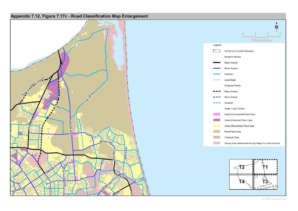
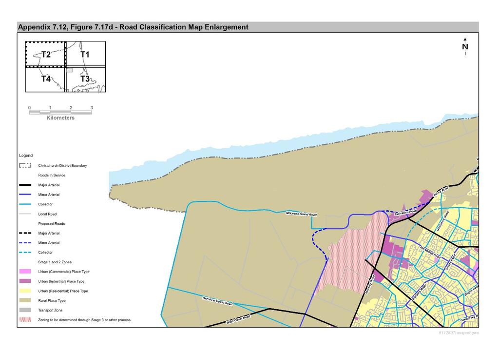
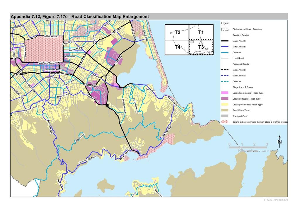
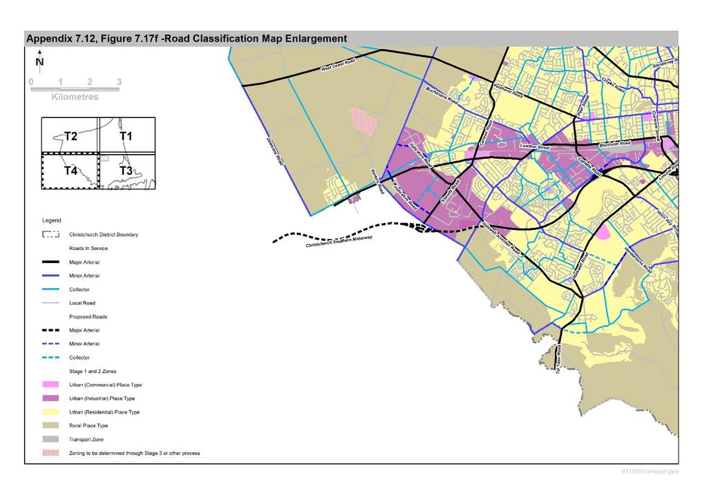
23 7.4 Appendices Figure 7.17 Road Classification Maps 23
24 24
25 25
26 Proposal 2: Definitions Transport System means all transport infrastructure, services, mechanisms and institutions that contribute to providing for transport, including key transport hubs, such as ports, airports and bus interchanges (# Christchurch International Airport). 26