Applying GIS Technologies in Agriculture in Lithuania
|
|
|
- Deirdre Howard
- 5 years ago
- Views:
Transcription
1 Applying GIS Technologies in Agriculture in Lithuania State institution Agri Information and rural business center Deputy head Birutė Martuzevičiūtė Director of IT department direktorius Jurij Lavrinovič
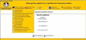
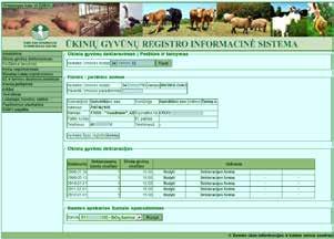
2 Information systems we manage and improve Livestock register Farming and rural business register Farm register Milk quota premium information system Breeding stock information systems (developing sheep and goat breeding systems) Cooperative farming registration system Horse breeding information system Dairy cattle breeding association database Tractor, self propelled and agricultural machinery register Milk quota trade system Information system of milk wholesaler data Agricultural and foodstuffs market information system Parcel declaration system Forage producers register Genetic evaluation and analysis system Agriculture studies and consulting information system

3 Register and information systems

4 Register and information systems


5 Register and information systems


6 Register and information systems

7 Registers and information systems
8 ABOUT US All register and information systems are created and improved by AGRO- INFORMATION AND RURAL BUSINESS CENTER staff. DEPARTMENTS: LIVESTOCK AND MILK QUOTA (RECORD) DEPARTMENT AGRICULTURAL ENTITY AND MACHINERY REGISTER DEPARTMENT GIS UNIT UNIT OF MARKET INFORMATION AND ECONOMIC ANALYSYS IT DEPARTMENT SUPPORTING DEPARTMENTS: GENERAL INFORMATION SERVICE UNIT MAINTENANCE UNIT FINANCE DEPARTMENT PRINTING UNIT DOCUMENT MANAGEMENT UNIT All this is AGRO - INFORMATION AND RURAL BUSINESS CENTER, the driving force in solving any problems and accomplishing the most challenging tasks set by Ministry of Agriculture and achieving excellent results.
9 IT evolution 1999 Contractors design information systems 2002 Reorganized AIRBC uses Borland Delphi and Oracle for application development 2008 All applications are developed using Microsoft.NET technology 2009 Programming, testing and production environments are completely separated 2010 Using ESRI GIS server and Silverlight for GIS application development 2011 GIS applications are upgraded using GIS server Under development

10 IT TECHNOLOGIES ARE USED FOR Database maintenance Software creation Implementation of GIS solutions Other purposes


11 SERVERS CONNECTIONS OTHER INVISIBLE IT GADGETS Crucial issue - efficiency of servers and data storage To ensure information security the main and reserve server rooms have been equipped. They provide security and ensure information availability in case of technical failure. All AIRBC information is kept in highly reliable storage units using RAID technologies. The storage units in the main server room are synchronized with the reserve server storage room to ensure information security. All the systems are clustered and their nodes are located in the main and reserve server rooms. In case of failure, the other cluster node starts functioning. Regular automated backups ensure information security


12 SERVERS CONNECTIONS OTHER INVISIBLE IT GADGETS Connection security and efficiency are very important AIRBC uses BGP, which ensures stable connection since there are two duplicate Internet lines from different Internet providers. In case of connection problems in one of the lines, all bandwidth is provided by the other one. For data exchange State secure network and encoded channels are used. Segmentation of all the internal networks and use of firewalls protect the internal networks. Optical network solutions are extensively used.


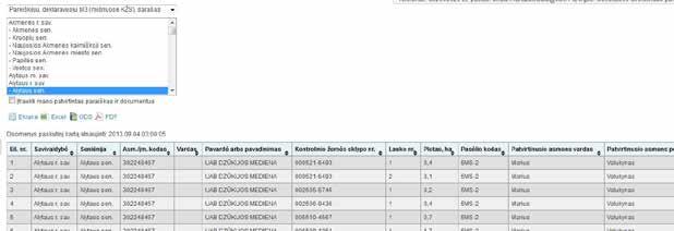
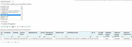
13 PARCEL DECLARATION SYSTEM IS THE MOST REMARKABLE ACHIEVEMENT


14 HISTORY OF PARCEL DECLARATION First declaration, GIS used only for reports LPIS starts in 2 pilot regions First LPIS version Paper maps printed for parcel declaration Pilot projects of electronic parcel declaration system First partly electronic declaration % electronic parcel declaration maintenance and improvement of declaration system in accordance with legislation amendments

15 the beginning The first steps were made in Applications collected by Agricultural consulting service No GIS or maps


16 First on-the-spot checks Declarations are submitted in the National Land Service. 2001

17 2003 Preparations for the first map fragments Printing the first map fragments in municipalities. Client program using ESRI, developed in AIRBC Since 2004 the majority of map fragments printed in AIRBC, the rest of fragments printed in municipalities Fields drawn by hand by the Land Service staff
 2007 - second pilot project")


18 the first Pilot project in 15 parishes (not mandatory declaration) second pilot project q mandatory electronic declaration in 24 parishes q 16 farmers q 3 agricultural enterprises q 35 land services 2008 the last pilot project q 338 parishes q 191 farmers q 29 enterprises q 50 municipalities q 17 land services


19 Since 2009 AIRBC has been responsible for parcel declaration. In 2010 it was decided that all applications for parcel declaration have to be electronic, paper forms were rejected. A map fragment is part of an application, therefore in 2010 it was decided to eliminate map fragments from application forms and submit them electronically instead. All application data are transferred electronically to the National Paying Agency under the Ministry of Agriculture.
20 Preparations for the 2011 parcel declaration This stage offers possibilities for making an application for declaration without being approved. Additional features: yet ; make a new application based on the application of the previous year; make corrections to the parcel boundaries drawn in 2010; generate and print map fragments for applications that have not been approved use real estate cadaster data of the Lithuanian Republic, on - the spot check data collected by the National Paying Agency and the drawn parcels the previous year. The most active users: Vilnius district municipality (more than 4,000 applications), Tauragė district municipality (2,700 applications), Kaišiadorys district municipality (2,500 applications), Šilalė district municipality (2,400 applications)

21 prepearions statistics


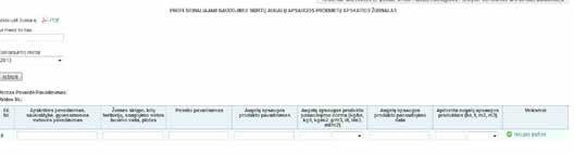
22 Economic value Economic value for each farm provided in the parcel declaration system offers the possibility of predicting taxes
23 USER INTERFACE We try to ease work for our users and make convenient and understandable instruments

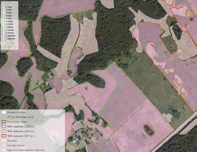
24 Cutting fields by other layers Cutting by other objects: 1. land block boundaries; 2. neighboring fields; 3. personal fields. Split a field by: 1. land block boundaries 2. Natura Natura 2000 in the forests 4. risk territories 5. swamps 5KV-2 5KV-2 5KV-2


25 USER INSTRUMENTS Ecologic buffer or its part Upload GPS measurements Editting Displaying area and distances


26 USER INSTRUMENTS Cut and split fields We try to provide new appropriate instruments Flexible measurement possibilities

27 User errors and warnings In time provided error messages and warnings offer the possibility of avoiding positional sanctions and make application processing faster and more comfortable...

28 Cross checks


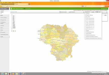
29 Cross checks

30 Errors reported in due time

31 To help farmers...

32 Additional information for other information systems

33 For other state institutions
34 MAIN TASK How can we serve 1000 active users at the same time?
35 Finding solution Load balance Application server Document server GIS server


36 PRODUCING RESPONSE Load balance


37 Information system of agricultural analysis The information system of agricultural analysis offers the possibility of seeing LPIS information, changes, history and the statistical information of municipalities and parishes using GIS tools.

38 We show territorial boundaries and addresses Information system of agricultural analysis
39 Information system of agricultural analysis

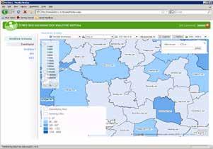
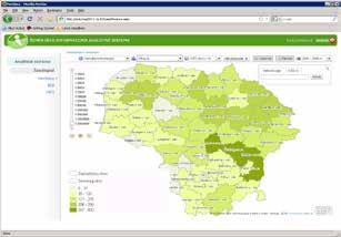
40 Information system of agricultural analysis
41 Thanks for attention