TUKASTANTIMES. Massive Earthquake Strikes Tukastan
|
|
|
- Tabitha Stevenson
- 5 years ago
- Views:
Transcription


1 SIMULATION ONLY Monday 14 November $2,50 TUKASTANTIMES Massive Earthquake Strikes Tukastan Tukastan Times. The President s office posted a statement on its website calling on the international community to mobilise all efforts to help the affected populations, the AFP news agency reports. Villages have been destroyed, and thousands are spending the night in emergency shelters or in the open. An estimated 60 villages sustained more than 50 percent damage. The death toll is expected to be in the thousands. The quake has created huge panic among the people, one resident told the Tukastan Times. Everyone has rushed to the streets and the sirens of ambulances are everywhere. Thousands of people are feared to have lost their lives and thousands more were injured in a 7.6-magnitude earthquake that hit Balkan in northern Tukastan on 14 November. The 7.6 magnitude earthquake struck Tukastan on Monday at 17:01 local time, causing large scale displacements, devastation to infrastructure, agriculture and the local economy. The full extent of the damage is still unknown. Tremors were felt across the region and aftershocks continued to shake through the country hours later. Many buildings collapsed and streets were destroyed in the capital of Tukastan, Claustan, where some international agencies and Non-Governmental Organizations are present. The government has declared a state of emergency in the affected areas and has officially requested international assistance. We need support from international agencies which are experienced and equipped with necessary tools to handle an emergency of this scale, a representative of the Ministry of Interior Affairs told the WFP in Action: Showcasing Technologies in Humanitarian Action Tukastan Times Page 1

2 2 WFP in Action: Showcasing Technologies in Humanitarian Action
3 3
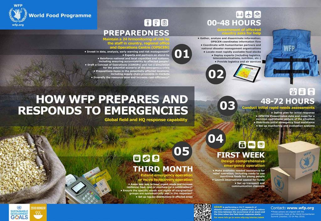
4 Timeline of Events DATE TIME EVENT LOCATION Monday 14 November Emergency Strikes Tuesday 15 November Setting up the Infrastructure Wednesday 16 November Understanding Needs 17:01 Earthquake strikes Tukastan Tukastan 18:50 Announcement: WFP in Action simulation begins WFP Auditorium 19:30 13:30 Action: Visit the to observe progress towards Setting up the Infrastructure Brief: Emergency Telecommunications Cluster, the Link to Survival 14:00 Brief: UAV Coordination Model 17:00 19:30 13:15 Action: Redeem SCOPECARD for commodities Action: Visit the to observe progress towards Understanding Needs Brief: ADAM, Automated Disaster Analysis and Mapping System Tukastan Market 13:30 Brief: Field Security 13:45 Brief: Accommodation service 14:00 Brief: VAM, Vulnerability Assessment Mapping 14:15 Brief: Supply Chain 14:30 Brief: LESS, Logistics Executive Support System 14:45 Brief: SCOPE, WFP s beneficiary and transfer management platform 17:00 Action: Redeem SCOPECARD for commodities Tukastan Market 19:00 Action: Visit the to observe progress towards Delivering Life-Saving Assistance Thursday 17 November 13:15 Brief: ADAM, Automated Disaster Analysis and Mapping System Delivering Life-Saving Assistance 13:30 Brief: Field Security 13:45 Brief: Accommodation service 14:00 Brief: VAM, Vulnerability Assessment Mapping 14:15 Brief: Supply Chain 14:30 Brief: LESS, Logistics Executive Support System 14:45 Brief: SCOPE, WFP s beneficiary and transfer management platform 4 WFP in Action: Showcasing Technologies in Humanitarian Action

5 Site map 5
6 WFP in Action: Solutions and Services ADAM, Automated Disaster Analysis and Mapping System Efficient management and rapid analysis of geospatial data is crucial for humanitarian agencies performing field operations on a global scale. Developed by WFP, the Automated Disaster Analysis and Mapping system (ADAM) collects, analyses and maps geospatial and socio-economic data related to natural hazard events. Performing data collection and analysis automatically 24 hours a day, seven days a week, ADAM reduces the time between the onset of a disaster and when the humanitarian response starts. ADAM is immediately activated following the occurrence of an earthquake, creating a dashboard with a map indicating the magnitude, location and depth of the earthquake; the estimated number of people living in the affected area; main infrastructures and WFP s presence, and calculates the distance to the closest WFP facility. ADAM represents an innovative near-real time disaster analysis tool for the humanitarian community. Emergency Telecommunications Cluster (ETC), the Link to Survival In humanitarian emergencies, communications is the link to survival. Under the global leadership of WFP, the Emergency Telecommunications Cluster (ETC) is a global network of organizations that work together to provide shared communications services in humanitarian emergencies. Within 48 hours of a disaster, the ETC provides vital security communications and internet connectivity services to assist the response community in their life-saving operations. Through its ETC2020 strategy, the cluster is evolving from being primarily a service provider, to broker, facilitator and convenor of technology in emergency response. By 2020, the ETC seeks to ensure that all those responding to humanitarian emergencies including affected communities have access to vital communications services and digital aid. UAV Coordination Unmanned Aerial Vehicles (UAVs), offer a multitude of innovative technology capabilities, resulting in a wealth of possibilities. As the application of UAVs is still new and largely undefined within the humanitarian space, WFP is establishing a coordination mechanism that supports better use of this technology, promoting safe and effective usage in a wide range of operational environments. Immediate UAV assessments allow for a diverse portfolio of rapid strategic planning applications that can be effectively used in humanitarian response around the globe. In order to fully utilize UAVs in emergency preparedness and response, the humanitarian community needs to ensure all actors are combining and coordinating efforts. Use of UAVs needs to serve local communities without putting them at risk while at the same time respecting governing rules and regulations of the disaster affected country. Field Security, Safety and Security to Access and Assist WFP Field Security ensures the safety and security of WFP personnel who access and assist people in need. With humanitarian operations in increasingly volatile and high risk security environments, WFP Field Security s formal risk management process ensures mitigation measures are adequate and appropriate for the numerous, and increasing security risks faced by personnel in the field. Comprising four units - Field Security Analysis, Field Security Operations, Security Training and Learning Development and Premises and Blast Assessment - WFP Field Security facilitates the life-saving operations of WFP. 6 WFP in Action: Showcasing Technologies in Humanitarian Action
7 Administration: Camp Management & Accommodation Booking Within days of a disaster, WFP can establish camp sites to provide accommodation and working spaces for WFP personnel as well as the wider humanitarian response community. WFP Accommodation is currently managing a network of more than 70 camps and guesthouses in 18 countries across the globe. The Accommodation Booking Service is the single entry point where UN Agencies, NGOs and interested stakeholders can book accommodation and access important information about WFP guesthouses and camps accompanied by pictures, prices and services provided. Camps and guesthouses are managed by WFP Administration, alongside light vehicle and driver management, equipment setup and catering services. VAM, Vulnerability Assessment Mapping One of the biggest challenges facing humanitarians in the immediate aftermath of sudden-onset emergencies is the lack of accurate information on impact: how many people need assistance, and where. In extremely challenging contexts, WFP Vulnerability Assessment Mapping (VAM) can present a sufficient snapshot of the impact of the disaster to fill this initial information void. The 72 hours assessment approach seeks to provide as-accurate-as-possible information to decision-makers in WFP, other humanitarian agencies and governments enabling them to take immediate and informed decisions. The approach offers a solid foundation for further continuous updates over the following weeks, as further information is gathered on the ground through field assessments. VAM is increasingly using innovative ways of collecting information in different operational environments such as satellite imagery, aerial photography and mobile-phone technology. LESS, Logistics Executive Support System The Logistics Executive Support System (LESS) is an online application that brings together supply chain management, inventory accounting and real-time tracking of WFP s entire food supply chain. Whether on the high seas, in port, on the road or in the most remote warehouse, LESS can tell us where our commodities are and their availability, down to the batch number, ensuring full visibility of WFP food commodities as they move along the supply chain, from point of receipt up to the final delivery for distribution. For the first time, supply chain information is now accessible to the entire organization in real-time and online through the same platform as WFP s corporate system (WINGS2). Mapping of the whole supply chain, logistics network and processes allows for the evaluation of the efficiency of warehouse set up, capacity, operations and cost. The LESS application helps WFP to be effective, cost-efficient, transparent and accountable, with improved planning and monitoring along the supply chain, ensuring that the right food is available to the right people at the right time. Shared Logistics Services: Aviation, Logistics Cluster, UN Humanitarian Response Depot WFP supports a variety of humanitarian actors in their delivery of aid through providing reliable and well-established logistics services. 7
 currently has a fleet of more than 70")

8 WFP Aviation organizes airlifts that deploy lifesaving assistance by plane within 48 hours. WFP is also responsible for implementing humanitarian passenger services where commercial options are insufficient; the UN Humanitarian Air Service (UNHAS) currently has a fleet of more than 70 chartered aircraft, flying aid workers to the most remote and isolated communities. As lead agency for the Logistics Cluster, WFP deploys dedicated and experienced logistics staff to emergencies to coordinate with humanitarian actors, collect and share information on logistic constraints and capacities, and facilitate common access to logistics assets (for storage and transport) provided both through WFP and our humanitarian and government partners. WFP manages the United Nations Humanitarian Response Depot (UNHRD), a network of six strategically located facilities that procure, store and transport aid on behalf of the humanitarian community. From Europe, Africa, the Middle East, Southeast Asia, and Latin America UNHRD can dispatch relief items to disaster-affected areas worldwide within 24 to 48 hours. SCOPE, WFP s beneficiary and transfer management platform SCOPE is a flexible and powerful solution that helps WFP to know better the people it serves, so they can be assisted in a more personalised way. SCOPE is used to manage operational information about beneficiaries, entitlements and transfers, enabling better decision-making and targeting. It supports cash, in-kind or commodity voucher modality, and can be scaled and adjusted for all types of interventions and context. SCOPE allows registration of beneficiaries with biometrics like fingerprints or iris-scan, enhancing assurance that the right assistance arrives to the right person. In emergencies, WFP uses SCOPE to rapidly register those in need, activate accounts and, where needed, instantly issue cards to each household, thereby giving them the chance to immediately gain access to assistance. All of this in the same day. Additional information on all participating divisions can be found here Acknowledgements The WFP in Action simulation is being coordinated by the IT Emergency Preparedness and Response Branch, in close collaboration with SCOPE, VAM, Emergency Preparedness & Support Response, Communications, Field Security, Administration and Supply Chain, and with the support of the Government of Luxembourg and Ericsson Response.