DEVELOPMENT REPORT UNION PACIFIC PROPERTY SAN ANTONO INTERMODAL YARD AREA
|
|
|
- Tabitha Elliott
- 5 years ago
- Views:
Transcription

1

2
3
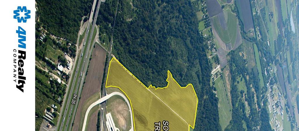
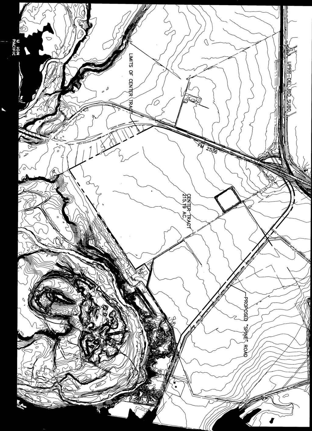
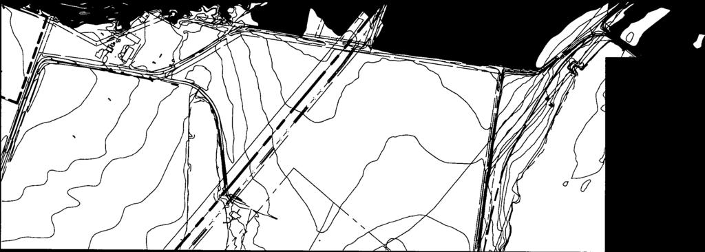
4 DEVELOPMENT REPORT UNION PACIFIC PROPERTY SAN ANTONO INTERMODAL YARD AREA This report was prepared to present development information (Utility availability, Development Regulations, Flood Plain information, etc.) on property owned by Union Pacific Railroad in the area of their Intermodal Yard in southwest Bexar County. For purposes of this report the property has been divided into three tracts known as the North, Center, and South Tracts. These divisions were made due to barriers such as roadways or other facilities that separate the areas. DESCRIPTION: CENTER TRACT The Center tract is bordered on the north by FM 2356 (Pearsall Road), on the west by an adjacent residential area, on the south by the Medina River and on the east by the proposed Union Pacific Spine Road connecting the Intermodal Yard to Pearsall Road. The tract contains approximately acres excluding the roadway. The property is currently being farmed. Three exhibits showing this tract are attached to this report. Exhibit C-1 shows the tract boundary along with proposed flood plains, potential roadways, a potential rail spur, potential detention ponds, and acreages. Exhibit C-2 is similar to Exhibit C-1 except that the potential roadways have been removed. Exhibit C-3 shows aerial topography for the tract. The topography shows one foot contours which were obtained during the Intermodal Yard design. Gross acreage of this tract is /- acres less 15 acres for detention basins results in a Net Acreage of /- acres. The detention basin area assumes that basin(s) six feet deep could be developed. The proposed Spine Roadway along the eastern side of the tract is not included in the acreage calculations. UTILITIES Electricity: The site is served by City Public Service (CPS), the City of San Antonio s Municipal Gas and Electric Utility. There are three phase overhead electric lines along the south side of FM 2536 for the eastern half of the tract s frontage on FM Three phase power has also been extended south along the west side of the future Spine Road to serve the Intermodal Yard. In addition there are three phase overhead lines located just south of the tract. These lines serve Bexar Metropolitan Water District s Pump station and are fed from a different substation. These lines could allow for dual feed service to proposed development. Electric service is available in accordance with CPS Regulations. 1
5 Water: The majority of the site is located in San Antonio Water System s Service Area. The nearest SAWS main is a 12 main located at the entrance to the Union Pacific Intermodal Terminal. Following the alignment of the proposed Spine Road the water line is approximately 4,700 feet from the southeast corner of the Center tract. In addition there is a project underway which will bring a 36 water main down Pearsall Road to a point approximately 8,200 feet east of the northeast corner of this tract. SAWS Capital Projects Plan currently shows a proposed main along this section of Pearsall Road. When a developer has to extend a main shown on the Capital Plan SAWS may elect to participate in the construction or the developer may be required to fund the entire cost with SAWS issuing credits towards the additional cost of the main required by SAWS over the cost of the main required by the development. These credits can be used to pay impact fees (with the exception of water supply fees) and may be sold to other developers. The Capital Plan does not include a main through the Union Pacific Property. SAWS is also in the design stage of a project which will construct a 42 +/- water transmission main along an alignment north of Nelson Road. At this time it is not known whether this will be available to support local distribution mains. To obtain water service SAWS will require execution of a Utility Service Agreement. This agreement details what improvements will be required to serve a tract and to what extent and under what conditions SAWS would participate or provide credits for the cost of main extensions. Application for Water Service will require submission of a proposed development plan and water demand calculations. In discussions with SAWS on the extension of water service to the Intermodal Yard SAWS initially required a main extension north from IH 35 to Pearsall Road. This requirement was removed since the line would not have had any customers to prevent stagnation of the water. It is likely that SAWS would require that extension as part of any development of this tract. In addition to main extension costs impact fees are required when meters are applied for. Fee schedules are available at A small portion of the property along the east bank of the Medina River is in the Atascosa Rural Water Supply Corporation (ARWSC) Service Area. As its name implies ARWSC primarily serves a rural clientele and does not have the capacity to serve industrial development on this tract. Should water service be needed in their service area it would likely be necessary to obtain an agreement allowing SAWS to serve the area. 2
6 Sewer: The site is located in the San Antonio Water System s Sewer Service Area. SAWS has a project under design called the Medina River Outfall which, when completed, will make sewer service available, subject to SAWS regulations, to properties along the Medina River. SAWS is currently in negotiations with Union Pacific to acquire an easement through this tract for the referenced line. The alignment preferred by SAWS is shown on the attached exhibits. Subject to being able to acquire the required easement the outfall should be completed by late In discussions between SAWS and Union Pacific Railroad (UPRR) representatives, SAWS personnel advised UPRR that sewer service connections could be made at manholes which are anticipated to be approximately one thousand feet apart. The adjacent Intermodal Yard has a private lift station and service is not available through that facility. As with water service SAWS requires a Utility Service Agreement as a condition to obtaining sewer service. In addition to main extension costs impact fees are required for sewer service. Fee schedules are available at For limited development it may be possible to utilize onsite wastewater treatment facilities if the Medina River Outfall has not been completed. Gas: City Public Service (CPS) does not have any gas service available in this immediate area. To extend a gas main to the FM 2356 frontage a main could be extended from Loop 410 and FM 2356 (a distance of 11,300 +/- feet. Extending a gas main to the south side of the site could be accomplished by extending a main southwesterly along IH 35 from Fischer Road and then following the Intermodal Access Road and proposed Spine Road alignment. That distance is 13,300 +/- feet. CPS does have a policy of subsidizing the cost of gas main extensions. The amount of subsidy depends on the anticipated gas usage. DEVELOPMENT REGULATIONS This property is located in the extra territorial jurisdiction of the City of San Antonio and is also located in Bexar County. Issuance of any building permit or sale of tracts would require that a subdivision plat be prepared and processed through both the City and Bexar County. The county will handle primary review for drainage and flood plain issues while the City will review land planning, tree preservation and other issues. Phased or partial development will require the processing of a Master Development Plan through the City. A Master Development Plan lays out how the property will be developed and addresses issues such as drainage, street layout, and traffic. 3
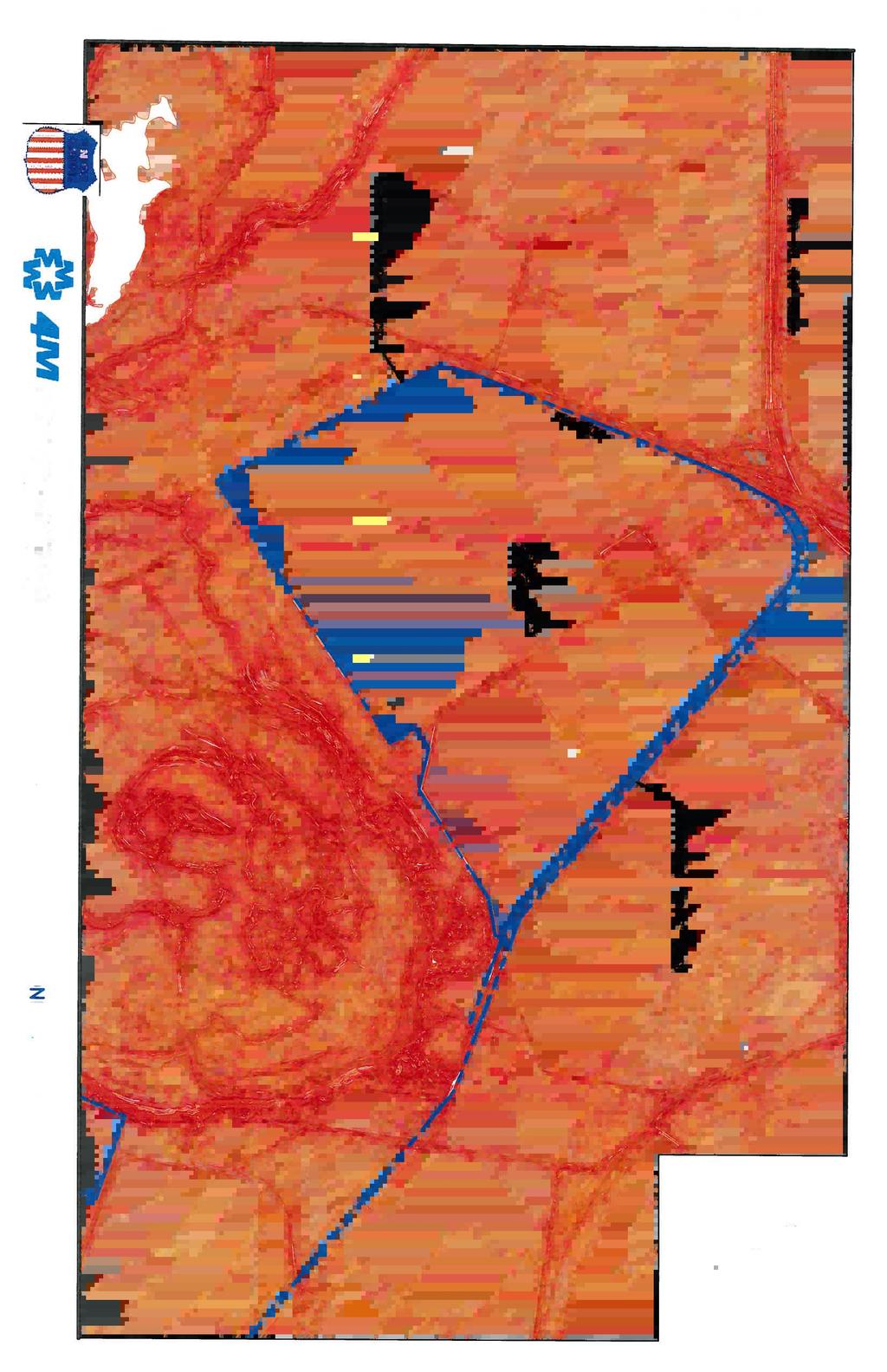
7 Building Permits will be processed through Bexar County. The permit process in the County primarily focuses on life safety issues The County does not have any land use regulations and the City s zoning does not extend into the county so there are no regulatory restrictions on land use. There is a water treatment plant intake on the Medina River immediately south of this tract and any development that would involve hazardous materials would likely be subject to increased scrutiny. The intake supplies water to a treatment plant owned by an affiliate of the Bexar Metropolitan Water District. The City s Tree Preservation Ordinance applies in the ETJ so any development will need to comply with Tree Preservation and Canopy requirements. Development of the Intermodal Yard included preserving an area of trees along the west side of this tract and adjacent to the Medina River Flood Plain. Unless modified by a new tree Preservation Plan those areas must remain protected. As part of the platting process the City of San Antonio requires TxDOT to review and approve the plat. During that process TxDOT determines whether they need additional right-of-way. On nearby plats TxDOT has requested that a ten foot wide right-of-way reservation be provided adjacent to the current right-of-way. TxDOT cannot require a dedication because the current right-of-way exceeds the City s requirements. They can require the reservation which makes the land available for their future purchase. FLOOD PLAIN DRAINAGE The City of San Antonio, Bexar County, and the San Antonio River Authority jointly sponsored an update of the FEMA Flood Plain Maps for Bexar County. The attached Flood Plain Exhibit shows the limits of the flood plain as proposed by this study. No part of the tract is in a regulatory flood plain. The maps showing this flood plain are expected to become effective the end of September, As part of their Unified Development Code the City of San Antonio requires that proposed development evaluate the impacts of their drainage on downstream development. If the evaluation shows that the development will not have an adverse impact the City rules allow payment of a fee in lieu of providing storm water detention. However, Bexar County does not participate in the fee and generally requires that storm water detention be provided for larger development. For planning purposes the required volume of detention facilities can be estimated as 0.4 acre feet of storage for each acre of development. The area required for detention will depend on the depth of the pond. For planning purposes a depth of four feet provides a required pond area of approximately one acre for each acre of development. 4
8 Based on a developable area of 215 acres the following table gives an estimate of the area required for detention basins of various depths. The actual area will depend on basin configuration, basin depth, type of development and other factors. Basin Depth Surface Area ACCESS 4 Feet 22 acres 5 Feet 18 acres 6 Feet 15 acres As shown on the attached topographic exhibit (C-3) the site generally slopes from northeast to southwest towards the Medina River. The southern boundary of this tract does not border the actual Medina River so any development plan that results in concentrated flow or pond outfalls would need to obtain drainage easements on the adjacent property. These easements would need to extend from the property to the river. Drainage of the tract could be accomplished by surface (earth or concrete channels) or subsurface (pipe) systems. All storm drain systems would need to be designed to City and County standards. This tract has frontage on FM 2356 which is a Texas Department of Transportation (TxDOT) controlled roadway and any driveways would need to be permitted through TxDOT. It should be noted that during the development of the Union Pacific Intermodal Yard the Southwest Independent School District (SWISD) was the catalyst in having Union Pacific Railroad relocate the access to the intermodal yard from FM 2356 to IH 35. Their concerns dealt with potential conflicts between truck traffic and school buses. SWISD utilizes FM 2356 as a major bus route since their Transportation Facility is located on Loop 410 just south of the FM 2356 intersection. Development with significant amounts of truck traffic will need to address the issue of possible conflicts with the buses. As part of the Intermodal Yard development the FM 2356 Bridge over the Union Pacific right-of-way was enlarged and space was left under the bridge for a roadway connecting this tract to the property south of FM A development with significant traffic might propose a roadway (as shown on Exhibit C-1) connecting to both sides of FM 2356 under this bridge to allow right in right out access to the property. This arrangement might satisfy the school district s concerns. The development of the Intermodal Yard included construction of a private roadway from IH 35 to the Intermodal Yard. This roadway is currently owned by Union Pacific but was designed to be converted into a public roadway to serve the Union Pacific Property. A roadway termed the Spine Road has been planned to extend north from the Intermodal Access Road to serve the South, Center, and potentially the North tract. The roadway 5
9 would involve a forty four foot wide roadway section in a seventy foot wide right-ofway. This roadway would also serve as a utility corridor for water, sewer, electric, gas and other utilities. An extension of this roadway could be made to serve development on this tract. Construction of this roadway would likely require storm drain improvements to convey runoff to the Medina River. As part of the platting process the City of San Antonio will require a Traffic Impact analysis. That analysis will determine the impact of any proposed development on roadways in the area. The development could be required to fund off-site roadway improvements if the analysis showed the projected traffic would degrade the level of service on the adjacent roadways. The City of San Antonio also requires TxDOT to review and approve the plat. During that process TxDOT determines whether they need additional right-of-way. On nearby plats TxDOT has requested that a ten foot wide right-of-way reservation be provided adjacent to the current right-of-way. TxDOT cannot require a dedication because the current right-of-way exceeds the City s requirements. They can require the reservation which makes the land available for their future purchase. RAIL ACCESS The attached exhibit (C-1) shows the potential for extension of rail service into the property from the lines entering the Intermodal Yard from UPRR s Del Rio tracks. Extension of rail service would require an agreement with Union Pacific. Where the tracks cross the Spine Road we would anticipate that crossing signals would be required. END OF CENTER TRACT 6
10
11


12
13 Seattle Spokane Eastport Portland Eugene Hinkle Duluth Minneapolis/ St. Paul Roseville Oakland San Francisco Los Angeles Long Beach Reno Stockton Fresno Colton Calexico Pocatello Las Vegas Tucson Phoenix Nogales Ogden Salt Lake City Cheyenne Denver Amarillo El Paso Eagle Pass North Platte San Antonio Laredo Omaha Topeka St. Louis Kansas Wichita City Oklahoma City Lubbock Ft.Worth Des Moines Little Rock Texarkana Dallas Houston Pine Bluff Shreveport Livonia Milwaukee Chicago Memphis New Orleans Brownsville

14 Union Pacific in Texas 2010 FAST FACTS Miles of Track 6,319 Annual Payroll In-State Purchases Capital Spending $576.8 million $1.9 billion $435 million Employees 7,391 RAIL CARS ORIGINATED IN TEXAS ,332, ,233, ,004, ,117,684 RAIL CARS TERMINATED IN TEXAS ,246, ,231, , ,175,896 Growth and investment continue Today, Union Pacific serves all major cities and gulf ports of Texas, as well as international gateways at El Paso, Eagle Pass, Laredo and Brownsville. Yet, the railroad s growth in the state continues. From , Union Pacific s capital investment in Texas was more than $1.5 billion. In 2007, UP broke ground in San Antonio on a $100 million state-of-the-art intermodal terminal, which is expected to generate $2.48 billion in cumulative economic impact for the area over 20 years. The facility will create as many as 200 jobs and will reduce traffic on San Antonio roads by more than 80,000 trucks each year.
15 Union Pacific in Texas (cont.) Union Pacific s Texas heritage Early railroad dreams in Texas were finally realized, after many false starts, in 1841 when a charter was issued to the Harrisburg Railroad and Trading Company. But after some modest grading, it failed. Its successor was the Buffalo Bayou, Brazos and Colorado (BBB&C). The BBB&C was issued a charter in 1850 and, by 1853, was operating the first railroad in Texas, a 20-mile stretch between Harrisburg and Stafford. The year 1853 also marked the birth of the Galveston and Red River Railway, which later became the Houston and Texas Central the first railroad to link Texas with Midwest and Eastern railroad connections. By 1888, Texas enjoyed a complex web of railroads that included Missouri Pacific, Missouri-Kansas-Texas, St. Louis Southwestern, Texas & North Orleans, and Texas & Pacific. By 1996, these railroads, and their modern successors, had become a part of the Union Pacific system in Texas. Supporting the communities we serve In 2010, Union Pacific provided more than $1.5 million to charitable organizations in Texas communities. This amount includes funding from Union Pacific Foundation for The Principals Partnership Program and the Community Grants Program. The Foundation s primary giving program, The Principals Partnership, provides 166 public high school principals with year-round, self-directed assistance from some of the nation s top education professionals. As part of this program, UP also sponsors a Summer Leadership Institute where principals come together to share insights and concerns and hear from nationally recognized speakers. Visit for more information. America s premier railroad Union Pacific Corporation owns one of America's leading transportation companies. Its principal operating company, Union Pacific Railroad, links 23 states in the western two-thirds of the country. Union Pacific serves many of the fastest-growing U.S. population centers and provides Americans with a fuel-efficient, environmentally responsible and safe mode of freight transportation. Union Pacific's diversified business mix includes Agricultural Products, Automotive, Chemicals, Energy, Industrial Products and Intermodal. The railroad emphasizes excellent customer service and offers competitive routes from all major West Coast and Gulf Coast ports to eastern gateways. Union Pacific connects with Canada's rail systems and is the only railroad serving all six major gateways to Mexico, making it North America's premier rail franchise. CONTACT US 24-Hour Emergency Hotline Response Management: (888) Corporate Headquarters: (402) or (888) Joseph Adams, Vice President-Public Affairs: (281) or joeadams@up.com Juan M. Carreon, Assistant Vice President Public Affairs (281) or jmcarreo@up.com Ivan Jaime, Public Affairs San Antonio and Texas Border: (210) or ijaime@up.com Clint Schelbitzki, Public Affairs North and Central Texas: (817) or ceschelb@up.com Raquel Espinoza, Media Relations: (281) or respinoza@up.com REV. 02/11

16 Union Pacific is pleased to announce the opening of the San Antonio Intermodal Terminal (SAIT), a $100 million state-of-the-art facility designed to support the growing intermodal volume in southern Texas. Covering more than 300 acres, this expansive facility is designed to handle 250,000 annual container lifts and is positioned to serve the cities of San Antonio, Austin, Eagle Pass and Laredo, as well as the entire south Texas market. Facility Features Eight-Lane Automated Gate System (AGS) Entrance Enhances gate capacity to improve gate/terminal throughput. Improves truck turn times seconds, as compared to a national average of four minutes. 1,300 Parking Stalls Provides ample capacity to process containers and creates faster availability for customers. State-of-the-Art Security Security fencing, biometric driver check-in, lighting and video surveillance provide a secure, theft-resistant environment for customers cargo while at the terminal. 24 Hour, Seven-Day-a-Week Operations Enhanced customer and motor carrier operational convenience and flexibility. Three Loading Tracks Allows for expedited loading/unloading, resulting in improved container availability. Future Expansion Union Pacific has designed this new facility with room for future expansion to keep pace with our customers' growth requirements. Interstate Access Convenient access to Interstates I-35 and I-410 makes it a key east-west and north-south turnstile, serving markets in all four directions. Oakland Los Angeles S a n A n t o n i o I n t e r m o d a l Te r m i n a l (SAIT) San Antonio Intermodal Terminal: Is positioned to serve more than 21 million square feet of warehouse space Serves one of the fastest-growing cities in Texas Is within 200 miles of the Mexico border and hundreds of Maquiladoras Is an alternative intermodal location for Mexico freight Provides competitive intermodal service between South Central Texas and the major markets of Los Angeles and Chicago Is adjacent to a logistic park with commercial property available for development Is centrally located in Texas, providing for efficient drayage to many markets Avoids congestion encountered in surrounding major metropolitan markets Seattle Portland Reno Las Vegas Phoenix Salt Lake City Tucson El Paso Denver San Antonio Kansas City Laredo Omaha Dallas Houston Brownsville Chicago St. Louis Memphis New Orleans Midland Odessa SAIT is positioned to serve the entire region and to be a critical gateway to Mexico. Current Lanes Future Lanes Eagle Pass MEXICO Abilene San Angelo Del Rio Laredo TEXAS Kerrville Austin 50 Boerne San Antonio McAllen Ft. Worth Kileen New Intermodal Facility (SAIT) Waco N Dallas Arlington 410 Houston Victoria Corpus Christi Brownsville College Station to Laredo Tyler Spring 10 SAN ANTONIO 410 Lufkin Baytown Galveston 37 Beaumont San Antonio to: Austin Corpus Christi Laredo Eagle Pass Houston McAllen Dallas Brownsville to Austin miles 143 miles 143 miles 145 miles 200 miles 245 miles 274 miles 278 miles Major warehouses/ distribution centers > 200 Maquiladoras 10 to Houston

 Location Operational Technologies Corporation 913 Billy Mitchell Blvd.")


17 SAN ANTONIO INTERMODAL TERMINAL U.S. Customs Contact Information U.S. Customs Border Patrol FIRMS Code : S518 Office Location: Port of Entry - San Antonio Port Code Airport Blvd, Suite 1101 San Antonio, TX Ph: Fax: Hours: Monday through Friday 8 a.m. to 5 p.m. CST Inspection Location: SW Freight 242 NW W. White Road San Antonio, TX Ph: Free Trade Zone (FTZ) Location Operational Technologies Corporation 913 Billy Mitchell Blvd. Suite 102 San Antonio, TX Ph: ext or 2191 Fax: Union Pacific is committed to protecting the environment now and for future generations. We are continually developing and investing in new technologies that provide for cleaner air and water, including a locomotive fleet that's the greenest in the industry. Green Facts: Rail transportation is three times more fuel efficient than trucking. One double-stack train can haul the equivalent of as many as 280 trucks IH35 South Von Ormy, TX THERE S A N EW S TA R I N T E XA S Laredo XAKile Austi Kerrville Boerne San Antonio Corpus Christi Houston
18