The Metropolis Plan. For Growth & Transportation
|
|
|
- Clement Kennedy
- 5 years ago
- Views:
Transcription

1 The Metropolis Plan For Growth & Transportation

2 Chicago Metropolis 2020 Created by the Commercial Club of Chicago Follows in the tradition of Daniel Burnham Goal: A region that will attract investment and create jobs.

3 Chicago region

4 Public Policy Actions Influence Private Choices Transportation Businesses/ Jobs/People Land Use


5 The Metropolis Plan for Growth & Transportation Modeling Future Development Scenarios Economic Model Transportation Model Land Use Model
6 Base Data

7 The Chicago region in 2030 Business As Usual
8 Economic Model: 2030 Results 1.8 million new people 630,000 new households 800,000 new jobs


9 Transportation Model: 2030 Results Trip lengths to workplaces: up 27% Use of transit for work trips: down 17% Trip length to non-work places: up 52% Total auto miles traveled: up 75%
10 Business as usual 490 additional square miles of agriculture or open space will be developed. The additional cost of new infrastructure in subdivisions is over $8 billion. There will be 4 new jobs in Cook County for every new home There will be 5 new homes in Will and McHenry Counties for every new job
11 Business as usual $40 billion in transportation spending Total miles of new major roads will increase by 4.3% Total distance driven will increase by 45% Hours driven will increase by 68% Average speed will decrease by 14% Average time for auto trip to work will increase by 40%

12 Creating the Metropolis Plan Regional Planning Workshops

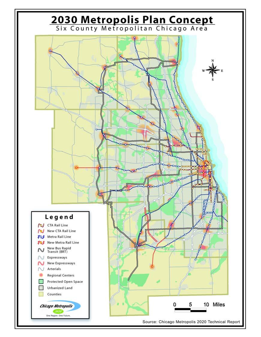
13 Choose a Starter Set and Place Chips on Map

14 Presentation of workshop maps


15 Step 1 Count and record the number and type of chips placed on each workshop map.


16 Step 2 Photograph and georeference the map images so the projection matches GIS data layers.


17 Step 3 Populate the grid by clicking where chips have been placed by participants.


18 Completed map shows how each chip is selected within the grid.

19 Workshop Results
20 Transportation EXPRESSWAYS North Freeway Link West Side Access to O Hare 355 Connection Peotone Connection
21 Transportation FREIGHT Waukegan Facility O Hare Facility Airport Connection Midway Facility Circumferential Freight Line Joliet Facility
22 Transportation ALTERNATIVE MODES Station Areas Mid-City Line Connects Airports Metra/CTA Integration at Mid-City Line Metra Lines
23 Land Use CONCEPTS Regional centers Town centers Chicago renewal and infill Areas of new development

24 Community Leaders Scenario
25 New acres of urbanization ,659 Business as Usual Community Leaders 80,849
26 Loss of total agricultural, forest and grassland 250, ,087 Acres lost 200, , ,000 50,000 0 Business as Usual Community Leaders 65,712
27 Regional cost of subdivision infrastructure (billions of dollars) $10.00 $8.17 Billions of dollars $8.00 $6.00 $4.00 $2.00 $0.00 Business as Usual Community Leaders $2.96
28
29

30 Planning for Freight Oriented Development

31 Freight Movement by Train National Context 1998

32 Freight Movement by Truck National Context 1998

33 Freight Movement by Truck Chicago 1999

34 The Region Today What are our choices for the future? Chicago Rail & Truck Freight Network

35 2003 Regional Truck Traffic Total Truck Traffic % of Traffic that is Truck

36 Firm Locations Freight Receivers Warehousing

37 The City of Chicago has designated 22 industrial corridors that comprise the major locations of industrial use in the City. Can this concept be applied elsewhere in the region? Industrial Corridors

38 Suburban Industrial Corridors There are no formally designated industrial corridors in the suburbs, though there are many areas that fit the same criteria These should be identified and evaluated for management

39 Land Uses Along Existing Rail
40 Land Uses along Rail Lines
41 All Industrial Land 105,250 acres of industrial land have been identified in the region. This is used as the core of the following analysis.

42 Adjacent to Class 1 Railroads 47,750 Acres of industrial land are immediately adjacent to Class 1 Rail Lines

43 2-1/2 Miles of Expressway Exit 58,900 acres of industrial land were identified within 2-1/2 miles of an expressway exit.

44 Truck Route Access Within the region a system of truck routes have been identified. We used this to create a Cost Surface of freight movement off of expressways.

45 Expanded Industrial Core in the context of Land Use The next logical step is to evaluate the context of each location to determine whether surrounding uses will support or undermine industrial use.

46 Top Suburban Industrial Corridors Best areas are two miles from expressway, adjacent to truck routes and adjacent to rail lines
47 2-Digit SIC Code Number of Firms in Chicago Industrial Corridors NGINEERING, ACCOUNTING, RESEARCH EMBERSHIP ORGANIZATIONS OCIAL SERVICES MUSEUMS DUCATIONAL SERVICES LEGAL SERVICES EALTH SERVICES AMUSEMENT MOTION PICTURES MISCELLANEOUS REPAIR AUTOMOTIVE REPAIR BUSINESS SERVICES PERSONAL SERVICES HOTELS, ROOMING HOUSES REAL ESTATE NSURANCE AGENTS SECURITY & COMMODITY BROKERS INSURANCE CARRIERS NONDEPOSITORY CREDIT INSTITUTIONS DEPOSITORY INSTITUTIONS MISCELLANEOUS RETAIL EATING AND DRINKING OTHER SERVICES HOME FURNITURE, FURNISHINGS APPAREL AND ACCESSORY PUBLIC FINANCE, ADMINISTRATION OF ADMINISTRATION ECONOMIC ENVIRONMENTAL QUALITY PROGRAMS ADMINISTRATION EXECUTIVE, LEGISLATIVE & JUSTICE NATIONAL SECURITY HEAVY CONST GENERAL GOVERNMENT BLD CON AL - GEN SER CON AG PROD - CROPS MINING FISHINGAG PROD - LIVESTOCK AUTOMOTIVE DEALERS FOOD STORES BUILDING MATERIALS GENERAL MERCHANDISE WHOLESALE TRADE - NONDURABLE WHOLESALE TRADE - DURABLE FABRICATED METAL PRIMARY PRODUCT META INDUSTRIAL AND COMMERCIA ELECTRONIC, ELECTRICAL MACHINERY EQUIPMENT & COMPONENTS,EQUIPMENT TRANSPORTATION EQUIPMENT MOTOR FREIGHT TRANSPORTATION INSTRUMENTS MISCELLANEOUS MANUFACTURING RAILROAD TRANSPORTATION TRANSPORTATION BY AIR LOCAL, USPS SUBURBAN TRANSIT TRANSPORTATION SERVICES COMMUNICATIONS FOOD TEXTILE APPAREL, FINISHED PRODUCT LUMBER AND WOOD PRODUCTS FURNITURE PETROLEUM LEATHE STONE, CLAY, GLASS, AN CONCRETE ELECTRIC, GAS AND SANITARY SERVICES CONST - SPECIAL TRAD PAPER PRINTING CHEMICALS RUBBER AND PLASTI WATER TRANSP
48 1-Digit SIC Codes Number of Firms - Chicago Industrial Corridors 8% 2% 6% 10% Construction 16% 21% 7% 13% Manufacturing Transportation Wholesale Retail FIRE Service Health Administration 17%
49 1-Digit SIC Codes Number of Employees Suburban Industrial Corridors 11% 17% 9% 0% 0% 4% 5% 15% 30% Mining Const Man Trans Who Ret FIRE Ser Health Admin 9%
50 Recommended Policies Develop intergovernmental units for effective action Key areas should be identified and priortizied by regional and state governments Expansion should be accommodated in local plans Targeted tax incentives for manufacturing and warehouse uses Build workforce housing in vicinity

51 Land Uses along Rail Lines

52 Rail Network

53 Freight Road Network

54 Intermodal Facilities
55 Container Yards

56 Abandoned Rail Lines Abandoned rail lines should be kept intact to be available for future transportation needs. Metra Line Abandoned Rail Lines
57 Chicago Metropolis West Monroe Street, 18 th Floor Chicago, IL / phone 312/ fax website