SR 50 PD&E Study
|
|
|
- Eric Jordan
- 5 years ago
- Views:
Transcription


1 SR50 Project Development & Environment Study Public Hearing November 1, 2011 SR 50 PD&E Study
 proposed as part of this project This Public Hearing is being held in accordance with: Chapter 23 of United States Code 128 Title 40 of the Code of Federal Regulations")
2 Purpose of the Public Hearing Afford persons the opportunity to express their views about the SR 50 project Afford persons the opportunity to express their views about any changes to Access Management (Median Openings) proposed as part of this project This Public Hearing is being held in accordance with: Chapter 23 of United States Code 128 Title 40 of the Code of Federal Regulations Parts 1500 through 1508 Title 23 of the Code of Federal Regulations Part 771 Federal Aid Highway Act of 1968, as amended Florida Statute Florida Statute 120 Americans with Disabilities Act of 1990 Title VI of the Civil Rights Act of 1964, as amended Title VIII of the Civil Rights Act of 1968, as amended Florida Statute , Access Management Executive Order Number 11988, Floodplain Management Executive Order Number 11990, Protection of Wetlands Executive Order Number 12898, Environmental Justice US Department of Transportation Act of 1966 Title 23 of the Code of Federal Regulations, Highways Title 40 of the Code of Federal Regulations, Highways Title 50 of the Code of Federal Regulations, Wildlife and Fisheries 2


3 Public participation at this hearing is solicited without regard to race, color, religion, sex, age, national origin, handicap, or family status. Persons wishing to express their concerns relative to adherence to Title VI may do so by contacting either: Florida Department of Transportation District Five Title VI Coordinator, Lorie Matthews 719 South Woodland Boulevard, MS DeLand, FL (386) Florida Department of Transportation Statewide Title VI Coordinator, Charlotte Thomas Equal Opportunity Office 605 Suwannee Street, MS 65 Tallahassee, FL (850) Project Purpose and Need 3


4 Project Purpose & Need Re-Align SR 50 Community Revitalization Increase Livability and Walkability Remove Heavy Truck Traffic from Downtown Improving Safety on SR 50 4


5 Regional Need The need for this project is identified in the following local and regional plans: City of Groveland Comprehensive Plan (as amended December 17, 2007), Transportation Element Policy Lake~Sumter Metropolitan Planning Organization, 2035 Long Range Transportation Plan Cost Feasible Plan Roadway Needs Plan Transit and Multimodal Needs Plan Bicycle-Pedestrian Needs Plan SR 50 Policy Constrained to 4-Lanes Lake County Comprehensive Plan, 2030 Planning Horizon Previous Studies/Concepts Downtown Groveland Redevelopment Plan 2006 Streetscape and lighting g Crittenden PD&E Study, South Lake Trail PD&E and Design Groveland City Council Agenda March 1,


6 SR 50 PD&E Study Traffic Analysis Base Year 2010 Future Traffic Projections Opening Year 2015 Mid-Design Year 2025 Design Year 2035 Traffic Distribution ib ti Daily Truck Percentage (10.43% to 18.01%) 6


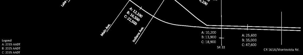
7 Existing Traffic Volumes Future Traffic Volumes 7


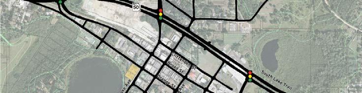
8 What We Are Evaluating. Re-Align SR 50 No-Build Alternative Build Alternatives To support Downtown redevelopment and revitalization Remove Heavy Truck Traffic Business core remains viable Stormwater Management Environmental Impacts Neighborhood & Business Impacts Connection with South Lake Trail Project Alternatives 8


9 Project Alternatives No-Build Alternative Build Alternativesti Realignment Alternative Truck Route Alternative Existing Typical Section 9


10 Proposed 4-Lane Urban Typical Section Proposed 4-Lane Urban Typical Section Re-striping at either end of project 10


11 Typical Sections Realignment Alternative 11

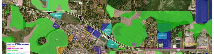


12 Detailed Realignment Alternative Detailed Realignment Alternative 12
13 Detailed Realignment Alternative Detailed Realignment Alternative 13


14 Detailed Realignment Alternative Truck Route Alternative 14


15 Detailed Truck Route Alternative Detailed Truck Route Alternative 15
16 Detailed Truck Route Alternative Detailed Truck Route Alternative 16

")

17 Detailed Truck Route Alternative Existing Drainage Features SR 19 Bisects Two Watersheds Ocklawaha River Basin (East of SR 19) Withlacoochee River Basin (West of SR 19) Outstanding Florida Waters (OFW) Closed Drainage Systems Double 48 Cross Drain Begin Study Exfiltration Trenches End Study 17
18 Proposed Drainage Two (2) Roadway Drainage Basins Three (3) Pond Site Alternatives per Basin Criteria Offsite Wet Detention Ponds Water Quality (SJRWMD) 1 over Total Basin Area or 2.5 over Impervious 50% Additional for OFW Water Quantity SJRWMD Pre vs Post 25 yr/24 hr FDOT Critical Duration (up to 100 yr/72 hr) Basin A 18


 Required")
 Required Pond Area (ac) A1 11.")


19 Basin B Realignment Alternative Truck Route Alternative Alternative Pond Sites Summary Basin A B Alignment Alternative Realignment and Truck Route Realignment Truck Route Pond Alt. ID Basin Area (ac) Required Treatment + Attenuation Vol. (ac-ft) Required Pond Area (ac) A A A B B B B B B


")


20 Park and Ride Lot - Potential Locations One site within Groveland Coordinate with pond parcels Potential new SmartRide Service (Lake Xpress) Coordinate with Stop Locations Double as Trailhead on weekends Park and Ride Lot - Potential Locations Realignment Alternative Truck Route Alternative 20
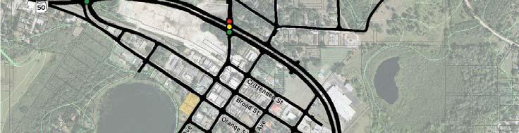
21 Access Management Changes Existing Access Class Class 3 Either side of Downtown Class 4 One-way Pairs Proposed change to Access Class 5 City Council Resolution If a Build Alternative is selected, the Truck Route Alternative is preferred Broad and Orange Streets - Will remain as one-way pairs South Lake Trail - Stay on planned Crittenden alignment 21


22 Environmental Considerations Engineering and Environmental Information was reviewed to determine changes to: Social Economic Physical and Natural Systems Compliance 22


23 Executive Order Floodplain Management Floodplain Analysis was performed Executive Order Wetland Evaluation was performed Executive Orders Wetland Impacts Five Wetlands within the project corridor Forested and Non-Forested Systems Hydrologic connection to the Palatlakaha River 23
24 Wetland Impacts No-Build 0 Realignment Alternative 0 Truck Route Alternative Build Alternative Roadway Direct Wetland Impacts 4.15 Realignment Alternative 1.94 Truck Route Alternative Pond Alternative Wetland Impacts acres Realignment Alternative acres Truck Route Alternative ti Park and Ride Wetland Impacts acres Realignment Alternative 0.0 Truck Route Alternative Wetland Mitigation Wetland Mitigation (2011/2012 Senate Bill) Realignment Alternative Realignment Alternative $372,090 (roadway) $0 - $198,098 (ponds) $0 - $76,514 (park and ride) Truck Route Alternative $206,484 (roadway) $0 - $288,239 (ponds) $0 $288,239 (ponds) $0 (park and ride) 24


25 Wildlife and Habitat USFWS Consultation Area for Florida Scrub Jay, Everglades Snail Kite, Lake Wales Ridge Plants Anticipating No Effect Potential Occurrence of 19 Listed Faunal Species Wildlife and Habitat Listed Species Utilizing Habitat within the Project Corridor Gopher Tortoise Burrows Located within the Project Corridor Mitigation for Impacts will be Required 25

")


26 Floodplains FEMA Zones A and AE (July 2002) Stormwater Master Plan by BCI (June 2006) Lower 100-year Floodplain Elevations from FEMA Impacts Expected 4.15 Realignment Alternative 1.94 Truck Route Alternative Soils 26


27 Contamination Site for potential contamination examined 32 total sites identified High Risk 1 Medium Risk - 7 Cultural Resources No archeological site impacts anticipated Alternatives ti are located approx. 400-ft north of historic train depot (no impact) Lake David Park located approx. 900-ft south of Orange Street (no impact) 27


28 Noise Noise Study Report prepared Barrier evaluations indicate noise barriers not cost reasonable Cost for benefited receivers all exceeded FDOT s guideline of $42,000 per benefited receiver No noise barriers proposed Maintenance of Traffic 28


29 Lighting Lighting currently exists along the project corridor Standard Cobra Heads on 8-ft arms Attached to concrete or wood poles City installed 14 solar powered poles in 2010 Lighting Justification Report prepared: Benefit-Cost Analysis warrants new lighting for both Build Alternatives Utilities There are 8 utilities within the project area Coordination with providers Design Survey- level data 29


30 Parcels and Relocations Residential Relocations along the northside of existing Patterson Street 1 Special Relocation Margaret Woodcraft Property 30


31 4 Residential Relocations along the westside of SR 19 Relocations If any Right-of-Way (R/W) relocation occurs, FDOT will carry out R/W relocation program in accordance with: Uniform Relocation Assistance and Real Property Acquisition Act of 1970, and Florida Statute

32 Relocations If changes occur, you will be contacted by appraiser Be present and provide information about the value of your property Eligibility for relocation advisory services and payment benefits You may appeal relocation determination Relocations If making an appeal: You will be promptly notified of procedures If you move before notification is received, benefits may be jeopardized Relocation specialists will answer any questions 32


33 R/W Brochures Project Costs Evaluation Criteria 'No-Build' "Realignment" "Truck Route" Alternative Alternative Alternative Preliminary Engineering $737,969 $737,969 $737,969 Final Design $0 $1,015,508 $941,199 Right-of-Way Acquisition $0 $11,903,000 $12,796,000 Construction $0 $10,155,075 $9,411,990 CEI $0 $1,320,160 $1,223,559 Total Project Costs $0 $25,131,711 $25,110,717 33

34 Truck Route - Recommended Alternative Project Schedule 34


35 Project Funding Phases Thank You Public Hearing 35