CHAPTER 1 INTRODUCTION AND PROJECT DESCRIPTION
|
|
|
- Alice Owen
- 5 years ago
- Views:
Transcription
1 CHAPTER 1 INTRODUCTION AND PROJECT DESCRIPTION 1.1 INTRODUCTION The U.S. Army Corps of Engineers (Corps, or USACE) and the City of Long Beach, acting by and through its Board of Harbor Commissioners (Port of Long Beach [Port or POLB]), have prepared this Final Environmental Impact Statement/ Environmental Impact Report/Application Summary Report (herein referenced as an EIS/EIR) to identify and evaluate the potential environmental impacts associated with implementation of the proposed Eagle Rock Aggregate Terminal Project (Project or Proposed Project). The Proposed Project involves the construction and operation of a sand, gravel, and granite aggregate (aggregate) receiving, storage, and distribution terminal located on a privately owned parcel at 1925 Pier D Street within the Port. The Project site is adjacent to Channel 3 and includes Berth D-44. Aggregate would be received from selfunloading Panamax-class vessels and stockpiled and loaded into trucks for distribution to area customers. Construction of the Proposed Project would require the dredging of approximately 6,000 cubic yards (cy) of material from Berth D-44 to accommodate Panamax-class vessels, disposal of the dredged material at the Middle Harbor Slip No. 1 Fill Site, site preparation, berth improvements, installation of a landbased conveyor and distribution system, and the placement of truck scales and a prefabricated (e.g., trailer) office building. The Applicant, Eagle Rock Aggregates, Inc. (Eagle Rock, or Applicant) has coordinated with the Dredge Material Management Team/ Contaminated Sediments Task Force on disposal options, and the dredged material would be disposed of in the Port's confined disposal facility associated with the Middle Harbor Redevelopment Project, which has been authorized by the Port and Corps under separate approvals. Operation of the Proposed Project would have a maximum throughput capacity of approximately 2.75 million tons of aggregate per year. At maximum capacity and peak hourly operation, the Project would result in an estimated 35 vessel calls per year and a maximum daily throughput of 770 one-way truck trips (385 inbound and 385 outbound). It is expected that construction of the Proposed Project would begin in early 2013 and reach maximum capacity by Section provides a description of the Proposed Project's construction and operation. The Project site was previously used as an aggregate import terminal by the Connolly- Pacific Company (C-P), which was operational from 2000 until That terminal received pre-sorted aggregate, which was made available for sale to construction contractors, ready-mix suppliers, and asphaltic concrete producers throughout the South Bay market area (SAIC, 2000). At the end of its operation, land-based materials and equipment were removed and the site has been vacant since that time. The three alternatives to the Proposed Project that are evaluated in detail in this EIS/EIR include the Pier B Street Alternative (Section ), the No Federal Action (NFA) Alternative (Section ) and the No Project Alternative (Section ). The USACE is the federal lead agency under the National Environmental Policy Act (NEPA) and is responsible for preparation of the EIS portions of this document. The Port, acting as the lead agency under the California Environmental Quality Act (CEQA), is responsible for preparation of the EIR portions of this document. Consistent with State CEQA Guidelines Sections and and Title 40, Section of the Code of Federal Regulations (CFR), the USACE and the Port have prepared this joint EIS/EIR as a single document to optimize efficiency and avoid duplication of effort. EAGLE ROCK AGGREGATE TERMINAL PROJECT 1-1 APRIL 2013
2 This EIS/EIR describes affected environmental resources and evaluates the potential impacts to those resources that would occur as a result of constructing and operating the Proposed Project and its alternatives. This document is intended to inform agencies and the public of significant environmental effects associated with implementation of the Project and its alternatives, as well as to propose mitigation measures that would avoid or reduce significant adverse environmental effects to the extent feasible. 1.2 USACE SCOPE OF REVIEW This EIS/EIR has been prepared in accordance with the requirements of NEPA (42 United States Code [USC] 4341 et seq.) and the Council on Environmental Quality (CEQ) regulations for implementing NEPA (40 CFR 1500 through1508), which require the evaluation of potential environmental impacts resulting from federal actions. The federal action associated with the Proposed Project is the decision by the USACE as to whether it should issue permits that would authorize proposed wharf improvements and related dredging activities in navigable waters of the United States under Section 10 of the Rivers and Harbors Act (RHA). The USACE has determined that these actions may result in potential adverse impacts to the natural and human environment and that preparation of an EIS is required. USACE permit decisions focus on direct impacts to the aquatic environment and indirect and cumulative impacts to upland areas as related to proposed dredging and wharf improvements, and thus have been found to be within the scope of federal control and responsibility. Please refer to Section (Alternative 1 Proposed Project, Construction) for a description of proposed dredging and wharf improvement activities. No other proposed upland modifications would be approved under the Corps' permitting process because all other upland impacts are outside of the Corps' jurisdiction. 1.3 ENVIRONMENTAL BASELINE NEPA and CEQA both require that an environmental review document establish and describe the environment of the area affected by a project and its alternatives. Referred to as the "Environmental Setting," or "Environmental Baseline," the affected environment is typically defined as the physical conditions of a project's site and its immediate surroundings prior to that project's implementation. The Environmental Baseline then provides the basis for evaluating a project's direct and indirect impacts and their significance (please refer to Section 2.1 for a discussion of a project's contribution to cumulative impacts, which typically requires an expanded area of analysis in comparison to the Environmental Baseline established for direct and indirect impacts). The following sections provide the assumptions and rationale that the Corps and Port have used to establish the Environmental Baseline used in this EIS/EIR and how it relates to the Proposed Project and its alternatives NEPA Baseline Despite the similarities between CEQA and NEPA, there are some areas where the two laws and their implementing regulations differ. In the case of the USACE s NEPA regulations, the analysis of a proposed project in a joint NEPA/CEQA document requires the Corps to distinguish the scientific and analytical basis of its decisions from those of the CEQA lead agency. For example, whereas CEQA requires the use of existing conditions as the baseline for analysis (please refer to Section 1.3.2), the NEPA Baseline for determining significance of impacts is defined by the No Federal Action condition, which is established by examining the full range of construction and operational activities that an applicant could, and is likely, to implement in the absence of a permit from the Corps. Activities that require a permit (e.g., activities within the Corps jurisdiction under Section 10 of the RHA) are not part of the NEPA Baseline. Therefore, the NEPA Baseline includes all of the construction and operational impacts likely to occur without in-water construction activities (e.g., the air emissions and traffic-related effects that are likely to occur without issuance of a permit for dredging). The determination is based on direct statements and empirical data from the EAGLE ROCK AGGREGATE TERMINAL PROJECT 1-2 APRIL 2013
3 Applicant, as well as the judgment and experience of the Corps. The NEPA Baseline is not bound to a no growth scenario. Potential impacts are determined by comparing conditions with and without the federal components of the Project at given points in the future (in this case, 2013 for construction and the maximum throughput activity year, which could occur in any operational year). The Corps evaluates the impacts of each alternative relative to the NEPA Baseline. The NEPA Baseline for the Project assumes that the site would function as an aggregate terminal with barges delivering aggregate material, in a manner nearly identical to its previous use. This use is further described in Section and identified throughout this EIS/EIR as the NFA Alternative (Alternative 3). This use is deemed to be the most likely future use of the site in the absence of a federal permit as it would meet the Project s most basic purpose, need and objectives, as outlined in Section 1.4. For this EIS/EIR, the NEPA Baseline includes only landside site improvements and operational activities that could occur without issuance of a federal permit. Accordingly, under the NEPA Baseline no channel or berth deepening would occur. The NEPA Baseline would include installation of a conveyor and truck loading system, product storage pads, truck scales, a pre-fabricated office building, and utilities and fencing at Berth D-44, as more fully described in Section CEQA Baseline The Port published and distributed its Notice of Preparation (NOP) to prepare an EIR on October 13, 2011 and has determined that the CEQA Baseline for this EIS/EIR reflects pre-project environmental conditions (i.e., no existing uses) as of October 13, PROJECT PURPOSE AND NEED AND PROJECT OBJECTIVES NEPA requires that an EIS explain the "underlying purpose and need" of a proposed action, or project (40 CFR ). Similarly, CEQA requires that an EIR state the objectives sought by a proposed project (State CEQA Guidelines Section 15124[b]). These respective discussions provide an understanding as to why the Corps and Port must act on the Project in the context of an EIS/EIR for their respective decision making processes, and the reasons why Eagle Rock is pursuing Project approval. The Proposed Project's purpose, need and objectives are also key to defining the alternatives that have been included in this EIS/EIR NEPA Project Purpose and Need The NEPA Project purpose and need is to establish a coastal aggregate receiving, storage and distribution facility that would optimize throughput capacity by providing up to 2.75 million tons of aggregate material per year to the greater Long Beach and Los Angeles areas. The Corps, on the basis of information furnished by the Applicant, has identified a need to establish a coastal aggregate receiving, storage, and distribution facility to meet the long-term construction aggregate needs of the greater Long Beach and Los Angeles market areas, and provide a reliable and competitively priced source of aggregate construction materials essential to the construction of new roadway infrastructure projects and other development projects that are anticipated to occur within the greater Long Beach and Los Angeles market areas CEQA Project Objectives The CEQA objectives of the Project are: (1) to establish a coastal aggregate receiving, storage, and distribution facility to meet the long-term construction aggregate needs of the greater Long Beach and Los Angeles market areas; (2) to provide a reliable and competitively priced source of aggregate construction materials essential to the construction of new roadway infrastructure projects and other development projects that are anticipated to occur within the greater Long Beach and Los Angeles market areas; and, (3) receive, store, and transport an annual throughput of 2.75 million tons of aggregate at full capacity. EAGLE ROCK AGGREGATE TERMINAL PROJECT 1-3 APRIL 2013
4 In 2006, the California Department of Conservation, Geological Survey, published a map (referred to as Map Sheet 52 ) and supporting report entitled Aggregate Availability in California (Kohler, 2006; Kohler et al., 2006). Map Sheet 52 and its supporting report compare projected aggregate demand over a 50-year period with permitted aggregate resources within 31 study areas of the State. Data regarding aggregate resources and projected aggregate demand that were used for Map Sheet 52 and its supporting report were updated from a series of mineral land classification reports prepared by the Geological Survey between 1981 and The mineral land classification process identifies State lands that contain economically significant mineral deposits. The primary goal of the mineral land classification is to ensure that the mineral resource potential of the State is recognized and considered in land use planning. The 50-year aggregate demand forecast for each of the aggregate study areas presented in Map Sheet 52 and its supporting report are for the period January 1, 2006 through December Before selecting a method for predicting a 50-year aggregate demand, historical aggregate use was compared to such factors as housing starts, gross national product, population, and several other economic factors. The Geological Survey found that the only factor showing a strong correlation to historical aggregate demand was population change. Consequently, a per capita aggregate consumption forecast model was used for most of the aggregate study projections. The California Department of Finance s 50-year county population forecast was used for the model, which is based on U.S. Census Bureau data. The per capita consumption model involved completion of the following steps: (1) collecting yearly historical production and population data for a period of years ranging from the 1960s through 2005; (2) dividing yearly aggregate production by the population for that same period to determine annual historical per capita consumption; (3) projecting yearly population for a 50-year period from the beginning of 2006 through 2055; and, (4) multiplying each year of projected population by the average historical per capita consumption, the sum of which equals a total 50-year aggregate demand. The Geological Survey noted in the report that the assumption that each person uses a certain amount of aggregate every year is a simplification of actual use patterns, but that overall, an increase in the population leads to the need for more aggregate. Over an extended period of time (e.g., 20 years or longer), random demand impacts from major public construction projects and economic recessions tend to level out and consumption trends become similar to historic per capita consumption rates. The Geologic Survey has found that the per capita consumption model is effective for predicting aggregate demand in major metropolitan areas. Map Sheet 52 and its supporting report conclude that there are approximately 4.34 billion tons of permitted aggregate resources within the 31 study areas evaluated, and that aggregate demand over the 50-year forecast period will be billion tons. With one exception, all of the study areas have less permitted aggregate than they are projected to need for the next 50 years, and 25 of the 31 study areas have less than half of the permitted resources they are projected to need. The Proposed Project s objective of contributing to the long-term aggregate needs of the greater Long Beach and Los Angeles areas fall within San Gabriel Valley study area of Map Sheet 52. As of 2006, this study area had an estimated 370 million tons of permitted aggregate resources available, and a forecasted 50-year demand of 1.15 billion tons, equating to a 68 percent shortage. As such, the Proposed Project's aggregate would help meet forecasted demand and provide the highest quality aggregate to meet the material specifications of public and private sector construction projects. 1.5 PROJECT HISTORY AND BACKGROUND As noted in Section 1.1, the Proposed Project site was previously used as an aggregate import terminal by C-P from 2000 until An EIR for the C-P facility was finalized, EAGLE ROCK AGGREGATE TERMINAL PROJECT 1-4 APRIL 2013
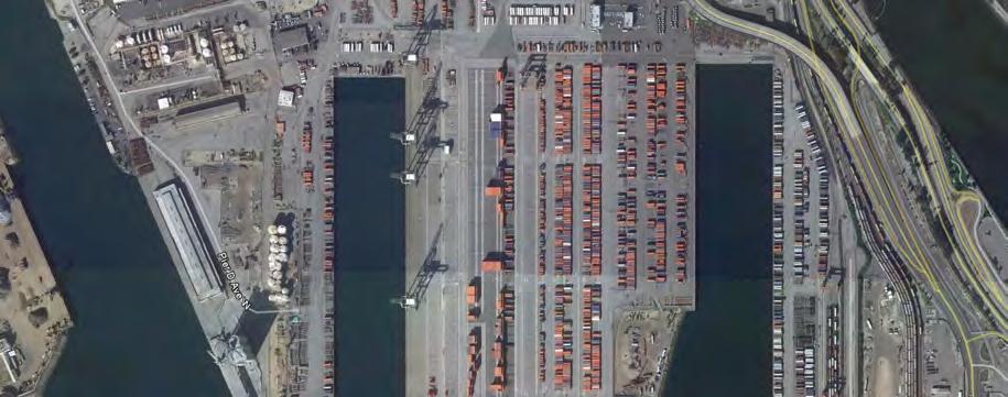
5 approved and certified in 2000 (State Clearinghouse Number [SAIC, 2000]). C-P leased the site from L. G. Everist, and the terminal received pre-sorted aggregate, which was made available for sale to construction contractors, ready-mix suppliers, and asphaltic concrete producers throughout the South Bay market area (SAIC, 2000). This facility was permitted to operate 360 days per year, five to seven days per week, with one to two work shifts per day. Aggregate was barged by dieselpowered tug boats to the terminal site and off-loaded and stockpiled by conveyor systems (SAIC, 2000). The permitted maximum annual throughput capacity was three million tons of aggregate, delivered by up to 250 barge trips annually at an estimated rate of five barge trips per week. The environmental analysis prepared for this facility considered approximately 125,000 round-trip truck trips annually (SAIC, 2000). However, a maximum throughput of three million tons of aggregate per year was never achieved; peak operations occurred between 2004 and 2006, during which time the volume of aggregate received and distributed over that three year period averaged an estimated 20,321 round-trip truck trips per year and 43 annual barge trips. At the end of its operation (2009), land-based materials and equipment were removed and the site has been vacant since that time. In June 2010, Eagle Rock submitted a HDP application to the Port for construction and operation of the Proposed Project. At that time, it was assumed that under the maximum annual throughput scenario up to 38 Panamax-class vessels would deliver aggregate materials to the Project site, and that up to 125,000 round-trip truck trips would deliver product to the Long Beach and Los Angeles market areas. In October 2011, the POLB published a NOP and supporting Initial Study that analyzed this Project scenario. However, since publication of the NOP the operational parameters of the Proposed Project have been further refined and this EIS/EIR assesses these refinements, which include a maximum throughput of 2.75 million tons of aggregate delivered by up to 35 Panamax-class vessels annually and distributed by up to an average of 110,000 round-trip truck trips per year, as further described in Section PROJECT LOCATION Regional Context The POLB is located in San Pedro Bay within the southwest portion of the City of Long Beach in southern Los Angeles County, California. The Port of Los Angeles (POLA) and the cities of Wilmington and San Pedro are located to its west and northwest. The Port is highly urbanized in character, and, at a regional scale, is accessed primarily by the Long Beach Freeway (I-710). Figure provides a map of the region within which the Port is located. The Port consists of 28 miles of waterfront and 3,200 acres of land including ten piers, 80 berths and 66 post-panamax gantry cranes. It is comprised of ten Harbor Planning Districts, and its principal uses include container terminals, petroleum and petrochemical and non-petroleum liquid bulk terminals, dry-bulk terminals, neo-bulk terminals, light manufacturing and industry, recreational destinations, and commercial operations, such as sport fishing concessions, hotels, retail shops and a public boat launch. The POLB is the second busiest Port in the United States. East Asian trade accounts for more than 90 percent of the shipments that go through the Port, and, in 2010, its throughput included 5,512 vessel calls and the handling of 6,263,499 containers (in twenty-foot equivalent units) and 76.6 million metric tons of cargo. As of 2010, the Port's topmost imports included crude oil, electronics, plastics, furniture and clothing and its leading exports included petroleum coke, petroleum bulk, chemicals, waste paper and foods Project Site and Vicinity The Proposed Project site is located at 1925 Pier D Street. The site is within the Port s Northeast Harbor Planning District (Planning District Number 2), between the Long Beach Harbor Back Channel and the Los Angeles River. The site is privately owned, zoned IP (Industrial Port) and is 8.3 acres in size. As EAGLE ROCK AGGREGATE TERMINAL PROJECT 1-5 APRIL 2013
6 shown in Figure 1.6-2, the site is bounded by Channel 3 and the SSA Marine (Matson) marine terminal (Pier C) to the north. The THUMS cogeneration facility and G. P. Gypsum Corporation are to the east, Berths D-41 through D-43 are to the west, and Pier D Street is to the south. Fire Boat Station Number 20 is located further to the west near Berth D-38. The Middle Harbor Slip No. 1 Fill Site is located southeast of the Proposed Project site, as indicated in Figure The Back Channel/Cerritos Channel Turning Basin is located approximately 1,890 feet west of the site; the Turning Basin is flanked to the north by a portion of Piers A and B, to the east by Piers C and D, to the west by Pier S, and to the south by the Back Channel. Land uses associated with these surrounding areas are all Port-related and industrial in character. Channel 3 is approximately 0.76 mile (4,013 feet) in length, and 450 feet wide between Berth D-44 and Pier C. Current bathymetric data for that area of Channel 3, which is adjacent to Berth D-44, indicate that existing water depths range from approximately -35 feet mean lower low water (MLLW) to feet MLLW; however, the majority of this area of Channel 3 is deeper than -40 feet MLLW (Nautilus Environmental, 2010). Water depths in this area of Channel 3 generally slope from slightly higher bathymetry in the east to deeper depths to the west (Nautilus Environmental, 2010). 1.7 PROJECT SETTING The Proposed Project site is 8.3 acres in size, of which the Project "footprint" would occupy 7.5 acres. With the exception of some remnant materials associated with the removal of the C-P facility, the Project site is vacant and within an area that is considered industrial in nature. The majority of the site's surface is made up of gravel and sand. The site is fenced on its three land sides and is devoid of native vegetation. The foundations of the former C-P facility's truck scales are located near the center of the site but with the exception of an electrical utility cabinet, there are no standing structures. The site includes Berth D-44, which currently contains five V- shaped steel stiff legs (part of the vessel mooring system) that extend into Channel 3 to accommodate the mooring of the barges that previously delivered aggregate to the C-P terminal. An additional L-shaped steel pier is located to the east of the vessel mooring system. 1.8 PROJECT DESCRIPTION AND ALTERNATIVES Background to the Alternatives NEPA (40 CFR [a]) and the State CEQA Guidelines (Section ) require that an EIS and EIR, respectively, examine a range of reasonable alternatives to a project that meet most of its basic objectives while reducing the severity of potentially significant environmental impacts. Five alternatives were considered during preparation of this EIS/EIR, including alternative construction schedules and phasing, upland disposal of dredged material, alternative site design plans, alternative locations, and other site uses. However, only three alternatives meet most of the Proposed Project s objectives and thus were carried forward for detailed analysis. As a frame of reference for both the alternatives considered but not carried forward for analysis (as described in Section 1.8.2) and the alternatives that have been evaluated in detail (as described in Section 1.8.3), it is noted that this EIS/EIR analyzes the smallest feasible aggregate terminal facility that could occur because the Port and Corps are not permitting any upland or in-water equipment or structures that could increase the amount of aggregate material stored at, or transferred through, either the Proposed Project site or its alternative site Alternatives Considered But Not Carried Forward for Analysis The screening process used in this EIS/EIR to evaluate a reasonable range of alternatives was based on the Proposed Project s purpose and need/objectives (Section 1.4). Screening criteria were also used to determine feasibility in accordance with the Port s legal mandates under the State Tidelands Trust and the Long Beach City Charter. The Port is one of only five locations in the State identified in the California Coastal Act (CCA) for the purposes of international maritime commerce. Port EAGLE ROCK AGGREGATE TERMINAL PROJECT 1-6 APRIL 2013

7


8
9 activities should be water dependent and give highest priority to navigation, shipping, and necessary support facilities to accommodate the demands of foreign and domestic waterborne commerce. This section describes the four alternatives considered but eliminated from detailed evaluation, including the rationale for the decision to eliminate them. Non-Phased Construction Alternative The Proposed Project and its two action alternatives (e.g., those alternatives that involve the development and operation of an aggregate terminal, as opposed to no development of any kind), all involve two phases of construction. Under Phase 1 a single truck scale and semi-portable conveyor system would be installed until the Project reaches an annual throughput of one million tons of aggregate material per year. Once this throughput is achieved, Phase 2 construction would include dismantling and replacement of the semi-portable conveyor system with a fixed conveyor system and the installation of a second truck scale. Under the Non-Phased Construction Alternative, Phase 1 construction would not occur. The Project site would be immediately constructed to Phase 2 specifications. Although this alternative would eliminate Phase 1 impacts associated with ground transportation and noise, these impacts have been determined to be less than significant and thus this alternative would not reduce any identified significant and unavoidable impact related to these two issue areas. Additionally, in comparison to the Proposed Project, this alternative would not reduce the impacts associated with dredging to a level of less than significant for nitrogen oxide (NOx) emissions. These emissions would still exceed the South Coast Air Quality Management District s (SCAQMD s) regional NOx emissions thresholds and localized NOx significance threshold. Upland Disposal Alternative The Proposed Project involves the dredging and disposal of 6,000 cy of material from Berth D-44. Under the Upland Disposal Alternative the material would not be disposed of at the Middle Harbor Slip No. 1 Fill Site but rather disposed of at an upland (e.g., onshore) location. This would eliminate the air quality impacts associated with a single barge trip or truck trips from Berth D-44 to the Middle Harbor Slip No. 1 Fill Site; however, due to dredging operations, impacts would still exceed the SCAQMD s regional NOx emissions thresholds and localized NOx significance threshold, and thus would not reduce an significant and unavoidable impact to less than significant. It is additionally noted that the Middle Harbor Slip No. 1 Fill Site has already been approved by the Corps for the disposal of dredged material. Full Enclosure Alternative Project operation includes the stockpiling of received aggregate materials in an area approximately 4.2 acres in size. The maximum practical stockpile dimensions have been estimated to be 150 feet wide and 50 feet high, with a full-pile circumference of 880 feet (AECOM US, 2012). Under the Full Enclosure Alternative, an enclosure would be constructed to cover the entire stockpile area to reduce impacts associated with the aggregate material s fugitive dust. Implementing the Full Enclosure Alternative would, however, increase the duration and intensity of construction-related activities, including increases in construction-related truck and employee vehicular trips and related increases in ground transportation impacts and air emissions. The impacts related with this alternative s construction were determined to result in minimal benefits because dust suppression measures, Mitigation Measures AQ-1 (see Section [Air Quality and Health Risk, Impacts and Mitigation Measures, Alternative 1 - Proposed Project]) and SCAQMD Rule 1157 would apply to the Proposed Project s operation, and the aggregate product has a high moisture content, which inherently reduces the potential for fugitive dust. Additionally, impacts associated with fugitive dust during Project operation have been determined to be less than significant; consequently, this alternative would not reduce an significant and unavoidable impact to less than significant. EAGLE ROCK AGGREGATE TERMINAL PROJECT 1-9 APRIL 2013
10 Alternate Use Alternative The Project site is located on a privately held parcel within the Port. Under the Alternate Use Alternative it is feasible that a different use could be implemented. Permitted uses in the Northeast Harbor Planning District, within which the Project is located, include: Primary Port Facilities (typically ship loading and unloading facilities, trans-shipment warehouses, stevedoring operations, open storage and transfer areas for cargo, and industrial operations primarily engaged in the shipment of goods and raw materials, and cruise ship facilities) Port-Related Uses (warehousing, distribution centers, container storage, railroad facilities, IV-1 container freight stations, ship chandlers, offices of public agencies involved in Port activities, and processing operations whose products or raw materials normally move through the Port) Hazardous Cargo Facilities (operations and terminals engaged in the loading, unloading, storage and transfer of crude, and bulk refined petroleum products and chemicals with a National Fire Protection Association rating of 2 or greater) Ancillary Port Facilities (typically ship building and repair, towboat and salvage operations, bunker barge loading, sport fishing launching, marine research, Coast Guard operations, marine-oriented fire protection, storage of equipment for dredging and waterfront construction, mobilization area for off-shore platform crews or oil spill clean-up operations, and improved harbor maintenance facilities) Oil Production (areas utilized for oil and gas production, tankage and processing plants, drilling sites and water injection wells) Navigation (established channels used for the movement of vessels into and out of the Port). Although the property owner could apply to implement one or more of the uses outlined above, the Port and Corps cannot reasonably predict which type of use or uses could be applied for. As a consequence, this alternative was deemed to be too speculative to pursue. Additionally, because a specific use or uses of all the site s permitted uses cannot be forecast with any certainty, the breadth, intensity and magnitude of the impacts associated with this alternative cannot be forecast without substantial conjecture. Depending on the use or uses applied for, significant and unavoidable impacts in addition to those created by the Project could occur and thus would not necessarily reduce any significant and unavoidable impacts Alternatives Evaluated in this EIS/EIR The alternatives evaluated in this EIS/EIR include the Proposed Project (Alternative 1), the Pier B Street Alternative (Alternative 2), the NFA Alternative (Alternative 3), and the No Project Alternative (Alternative 4). With the exception of the No Project Alternative, all of these alternatives would meet at least some objectives of the Project. Direct, indirect and cumulative impacts associated with construction and operation of the Project and its alternatives are evaluated, and a comparison of them is provided in Chapter 4 of this EIS/EIR. As related to operational impacts, it is noted that the daily operation of an aggregate marine terminal is highly variable and dependent on market demand. Under typical conditions, activities associated with any given work shift tend to be the highest during the first three to four hours of that shift, and subsequently taper off as the shift nears its end. However, on occasion large construction projects can demand aggregate material for continuous or nearly continuous periods of concrete pouring, which would cause the terminal to operate an estimated 16 hours per day until that demand is met. To capture the impacts associated with these uppermost periods of activity, operational impacts for all of the alternatives have been evaluated against a "worst case" scenario of maximum peak hourly operation, which reflects the maximum amount of aggregate that could be loaded into trucks and exit the site at any time. EAGLE ROCK AGGREGATE TERMINAL PROJECT 1-10 APRIL 2013

11
12 A key to the worst case scenario is that all of the alternatives have a maximum Project "footprint" of 7.5 acres, and a maximum stockpiling area of 4.2 acres. This physically limits their maximum stockpiling capacity, as well as the number of trucks that could enter, load, weigh-in and leave the site in any given hour. As illustrated in Figure 1.8-1, after being loaded onto conveyors from the vessel, cargo would be deposited in a donut-shaped pile within the site. Given the available stockpiling area (4.2 acres), the maximum practical storage pile dimensions would be 150 feet wide and 50 feet high, with a full-pile circumference of 880 feet (AECOM US, 2012). These dimensions yield a maximum storage capacity of 154,000 tons of aggregate material at any given time (AECOM US, 2012). Given these maximum stockpiling dimensions, in conjunction with site size, no more than a maximum internal queue of 20 trucks is expected. Combined with the expected service time for each truck (e.g., loading and weighing), the facility is expected to have a peak hourly truck service rate of 32 trucks per hour. Figure illustrates operation of the Proposed Project site with a queue of 20 trucks. As a result of these operational parameters, the site s maximum annual throughput is 2.75 million tons of aggregate material. Given the above, and to capture potential impacts associated with peak demand (e.g., responding to continuous concrete pouring), the "worst case" scenario evaluated in this EIS/EIR assumes that the Project would operate 88 hours per week, 52 weeks per year, with two eight-hour shifts on weekdays (Monday through Friday, 6:00 am to 2:00 pm and 2:00 pm to 10:00 pm) and one eight-hour shift on weekends (Saturday, 6:00 am to 2:00 pm). Within the context of a 16-hour operational day, it is also assumed that the Project would not be able to sustain the loading of 32 trucks per hour continuously, but rather that there would be some fluctuation in the number of trucks entering and leaving the site from hour to hour. As such, and in consideration of the throughput analysis prepared for the Project (AECOM US, 2012) and data provided by the Applicant for a similar facility in the Port of Richmond, it is assumed that under peak operating conditions the Project would result in the generation of 770 one-way truck trips per day (385 inbound and 385 outbound) under the worst case scenario. Assuming that each truck would be fully loaded and have a carrying capacity of 25 tons, this would result in a maximum outbound daily distribution of 9,625 tons of aggregate material to area customers. Although this document analyzes the worst case peak hourly operation, it is noted that for the vast majority of any operational year the Project would normally operate no more than 48 hours per week (one eight-hour work shift each weekday and one eight-hour work shift on Saturday) Alternative 1 Proposed Project Project Elements The Proposed Project would consist of a vessel berthing facility at Berth D-44, a conveyor and truck loading system, product storage pads (stockpiling areas), truck scales, a pre-fabricated office building, and utilities and fencing. As proposed, the Project would have a maximum throughput of 2.75 million tons of aggregate product per year; product would be delivered to the site by up to 35 Panamaxclass vessels annually and transported to local and regional customers via an estimated 770 one-way truck trips per day. Construction would start in early 2013 and the Proposed Project would be operational by late Further details regarding the Proposed Project are provided below. Construction Construction of the Proposed Project would occur in two phases. Phase 1 would involve dredging, wharf improvements and the installation of a semi-portable conveyor system and a single truck scale (Figure 1.8-2). Phase 1 construction would occur over an approximate five-month period to allow for initial operation of the Project. Phase 2 (Figure 1.8-3) would consist of the installation of a fixed conveyor system and a second truck scale that would be constructed occur over an EAGLE ROCK AGGREGATE TERMINAL PROJECT 1-12 APRIL 2013

13

14
15 TABLE SUMMARY OF PHASE 1 CONSTRUCTION: PROPOSED PROJECT (ALTERNATIVE 1) Construction Month Construction Activity Site Preparation & Dredging Pile Driving Concrete Forming Steel Erection, Truck Scale & Office Building Electrical Source: Eagle Rock Aggregates Inc., 2011a. estimated three-month period. It is expected that Phase 2 would be complete by December 2016, at which time market demand is anticipated to increase to over one million tons of aggregate material per year. Phase 1 construction would require an average workforce of six personnel and a maximum workforce of nine to ten personnel during dredging; work would occur Monday through Friday for up to eight hours per day. The onshore workforce would access the Proposed Project site from Pier D Street and park within the site's fenced boundaries. As shown in Table 1.8-1, site preparation would take approximately one month and would be completed by a workforce of six personnel working Monday through Friday from 8:00 am to 4:00 pm. Following site preparation, wharf improvements would include the dredging of an estimated 6,000 cy of material in Channel 3 to accommodate the movement and berthing of Panamax-class vessels. The majority of the dredge site would be excavated to a depth of -44 feet MLLW plus a 2-foot overdredge allowance (-46 feet MLLW). The dredge site is anticipated to contain a high degree of fine sediments susceptible to erosion and re-deposition; consequently, advanced maintenance dredging (AMD) of a 2-foot trough at the base of the berthing area is also proposed to minimize the future accumulation of sediments and reduce the frequency of long-term maintenance dredging once the Project is operational; the trough would be approximately 400 feet long and 20 feet wide (Nautilus Environmental, 2010). It is currently anticipated that the dredged material would be used for development of the POLB Middle Harbor Redevelopment Project, which has been approved by the Corps for the disposal of dredged material. Dredging activities would occur in a single day during the first month of construction and would require a crew of three to four workers operating one diesel powered clam-shell dredge, one barge and a tugboat. Should the Proposed Project s final construction schedule allow, its dredge material disposal would entail one barge trip between Berth D-44 and the Middle Harbor Slip No. 1 Fill Site (Figure 1.6-2). However, in the event that barging the dredge material is not feasible due to scheduling conflicts, the material would be trucked to the Middle Harbor Slip No. 1 Fill Site. The dredge material would be loaded onto a barge at Berth D-44, and then pumped to a containment area within the Project site. The containment area would include Best Management Practices (BMPs) to ensure runoff does not leave the site and enter the stormwater or sewer system. The dredge material would then be loaded onto trucks with a front end loader, and the loaded trucks would use Pier D Street to enter Middle Harbor. The dredge material would then be unloaded directly into the fill site, although one front end loader may be needed to push excess material into the fill site as well. An estimated 250 round-trip truck trips from the Project site to Middle Harbor would be needed for this disposal option. It is anticipated that trucking the dredge material to the Middle Harbor Slip No. 1 Fill Site would take up to two days to complete. EAGLE ROCK AGGREGATE TERMINAL PROJECT 1-15 APRIL 2013
16 Following the completion of dredging, 28 steel pilings would be driven into the landbased ground surface using a crane and vibratory pile driver mounted on a backhoe. It is estimated that installation of the pilings would occur over one month, including concrete forming. Approximately eight pairs of steel legs ranging in size between two and four feet in length for the semi-portable conveyor system and the wharf's two stiff legs would be transported to the Proposed Project site by truck and erected within the third and fourth months of construction. The wharf's stiff legs would connect to the pilings onshore above the high-water line, and would be approximately feet long. Assembly and installation of the stiff legs would require a crew of three to four workers working Monday through Friday from 8:00 am to 4:00 pm for an estimated two weeks. Two fenders would then be installed at the end of each stiff leg for vessel berthing. Onshore erection of the semi-portable conveyor system and truck scale would require an estimated construction crew of four workers working Monday through Friday from 8:00 am to 4:00 pm. Following the steel work, installation of an electrical system for operation of the semiportable conveyor would be completed in the fifth month of construction by a workforce of two to three personnel working Monday through Friday from 8:00 am to 4:00 pm. When the Proposed Project's throughput reaches one million tons of aggregate material per year, the semi-portable conveyor system would be dismantled and replaced with a fixed conveyor system and a second truck scale would be installed, as shown in Figure Referred to as Phase 2, this construction activity would occur over a three-month period, as shown in Table 1.8-2, and would be limited to onshore activities. Erection of the fixed conveyor system and installation of the second truck scale would occur in the first two months and would require three to four workers working Monday through Friday from 8:00 am to 4:00 pm. As with Phase 1, the steel beams and equipment for the conveyor system and the truck scale would be delivered to the site by truck. An electrical system for operation of the fixed conveyor would then be installed in the second and third months. This installation would require two to three workers working Monday through Friday from 8:00 am to 4:00 pm. Once operational, the semi-portable conveyor system would be dismantled over a two-week period by a crew of four workers working Monday through Friday from 8:00 am to 4:00 pm, and its equipment and steel beams would be reused in the Phase 2 system or otherwise relocated off-site. Operation Aggregate material would be delivered to the Project site via Panamax-class vessels originating from two quarry locations in British Columbia, Canada. These vessels are an estimated 804 feet in length with a beam of 105 feet, a draft of 44 feet, and a deadweight capacity of up to 80,000 short tons. It is currently anticipated that operation of the Proposed Project would begin in the spring of 2013 and reach its full throughput capacity of 2.75 million tons per year by 2020, as illustrated in Table Vessels would enter the Port through Queens Gate and pass through the Outer Harbor, Long Beach Channel and Back Channel to the Back Channel/Cerritos Channel Turning Basin, where they would turn to enter Channel 3. The Applicant has coordinated with the Port Pilot and would comply with any vessel movement and berthing recommendations that the Port Pilot suggests, including the existing Memorandum of Agreement (MOA) among Channel 3 tenants. Shipping schedules among the tenants of Channel 3 are shared to minimize potential vessel congestion. The vessels would be offset from the pierhead line by an estimated 25 feet. A pierhead line is a boundary established by the Corps within a navigable waterway that lies parallel to that waterway's mean low tide line; the boundary, or line, establishes the farthest distance from shore that any manmade structures, such as the Project's stiff legs, can extend into the water. Aggregate would be conveyed to the landbased conveyance and distribution system via vessel-mounted booms that are approximately EAGLE ROCK AGGREGATE TERMINAL PROJECT 1-16 APRIL 2013
17 TABLE SUMMARY OF PHASE 2 CONSTRUCTION: PROPOSED PROJECT (ALTERNATIVE 1) Construction Month Construction Activity Steel Erection Electrical Source: Eagle Rock Aggregates Inc., 2011a. TABLE ANTICIPATED ANNUAL THROUGHPUT LEADING TO PROPOSED MAXIMUM CAPACITY: PROPOSED PROJECT (ALTERNATIVE 1) Operational Year Tons of Aggregate Throughput Number of Panamax- Class Vessels Average Number of Round-Trip Truckloads , , , , , , ,000, , ,500, , ,000, , ,500, , ,750, ,000 Source: Eagle Rock Aggregates Inc., 2011b. 262 feet in length. Although the volume and types of product received at any given time would be contingent on market demand, it is estimated that at maximum capacity 60 percent of the material would be sand and 40 percent would be gravel and granite aggregate. The aggregate would be unloaded onto stockpiles on the site (Figures and 1.8-2). The vessels would have an offloading rate of approximately 3,000 to 5,000 short tons per hour, for a total off-loading time of 16 to 27 hours for full shiploads. While at berth, the vessels would use their auxiliary electric generating systems for power; electricity would not be provided from shore, as further addressed in Section 1.9. Operation of the Project at peak hourly throughput would require a maximum of four full-time employees, including two equipment (e.g., front-end loader) operators, one weigh master and a site manager. When a vessel is at berth, approximately four to six additional workers (longshoremen) would be on site. Employees would park on site and enter and exit the facility via Pier D Street. Stockpiled materials would be loaded onto trucks by two large (Tier 4) front-end loaders at a rate of approximately three minutes per truck. Trucks would enter and exit the site via Pier D Street. The majority of the loaded trucks would deliver product to ready-mix plants located within an estimated 20-mile radius of the Port. As described in Section 1.8.3, a maximum of 32 trucks per hour could enter, load, weigh-in and exit the site under any operational year (AECOM US, 2012); however, even under peak operating conditions it is not expected that loading 32 trucks per hour could be sustained for an entire 16-hour day. Peak operation of the Project is estimated to have a daily throughput of up to 770 one-way trucks per day (assuming two eight-hour shifts), thereby distributing up to 9,625 tons of EAGLE ROCK AGGREGATE TERMINAL PROJECT 1-17 APRIL 2013
18 aggregate material daily. At full throughput capacity (2.75 million tons annually), this would equal an average of 110,000 roundtrip truck trips per year Alternative 2 Pier B Street Alternative Project Elements The Pier B Street Alternative (Alternative 2) is located at 1710 Pier B Street, approximately 500 feet east of the intersection of Edison Street and Pier B Street (Figure 1.8-4). The site is an estimated 12.6 acres in size, located within the Port's Northeast Harbor Planning District, and zoned IP. The site is within an area of the Port that has been developed for industrial uses for over 70 years. There are no standing structures or buildings on the site; the only existing development features are a remnant concrete pad and partial storage shack that were used for previous site uses, as described further below. These features would be removed as part of Project construction. Five oil production wells are also located within the boundaries of the site; however, they have all been shut down. Vessels access the site from the Back Channel/Cerritos Channel Turning Basin and enter Channel 2 from the west. Channel 2 is approximately 0.75 mile (3,978 feet) in length and an estimated 535 feet in width at Berths B84-B87. Existing water depths of Channel 2 can accommodate Panamax-class vessels. The vessels would dock at the wharf at Berths B84-B87, which is cooperatively shared between the National Gypsum Company, Toyota Logistics Services, Tesoro Refining & Marketing, and Petro Diamond Terminal Company. If the Project were to be located at this site, the Applicant would be the last entity able to dock at Berths B84-B87. The Pier B Street Alternative site was formerly used by the J. H. Baxter Company as a wood treatment facility from 1924 to 2001, and subsequently used as a transload depot for wood being shipped both domestically and internationally from 2001 to Surrounding land uses are highly industrialized and include roads and railroad lines to the north, Long Beach Harbor to the south, a vehicle storage lot, oil production wells and a BP Pipelines North America fuel storage tank farm to the east, and National Gypsum s manufacturing plant to the west. In addition, the site is located within the boundaries of the Wilmington Oil Field, and the Tidelands Oil Production Company currently operates a drilling area immediately south of the site on behalf of Occidental Petroleum Corporation (Oxy). The wood treatment and preservation chemicals used by the J. H. Baxter Company contained metals, volatile organic compounds, semivolatile compounds, dioxins and petroleum hydrocompounds that have contaminated the site. Consequently, the Pier B Street Alternative is considered a brownfield site and is scheduled to be remediated for beneficial reuse under the Department of Toxic Substances Control s (DTSC's) California Land Reuse and Revitalization Act (CLRRA) of The CLRRA provides liability protections to brownfield developers, innocent landowners and contiguous property owners who intend to promote the cleanup and redevelopment of contaminated properties. The "footprint" of the Pier B Street Alternative would be identical in size to the Proposed Project (7.5 aces), of which 4.2 acres would be used for the stockpiling of aggregate materials. This alternative would have a maximum annual throughput of 2.75 million tons of aggregate material that would be delivered to the site by up to 35 self-unloading Panamaxclass vessels and transported to local and regional customers by up to 110,000 round-trip trucks trips per year. Aggregate would be received at Berths B84-B87 and conveyed over the wharf to the site's stockpiling areas, as illustrated in Figure Construction of this alternative would start in early 2013 and the terminal would be operational by the fall of As with the Proposed Project, the annual throughput of Alternative 2 would incrementally increase over an estimated eight-year period. Details regarding construction and operation of this alternative are provided below. Construction Similar to the Proposed Project, Alternative 2 would be constructed in two phases. However, no dredging activities or wharf improvements EAGLE ROCK AGGREGATE TERMINAL PROJECT 1-18 APRIL 2013

19

20