Final Report South Coast Corridor Multi-Modal Study. Prepared for Government Office for the South East
|
|
|
- Robert Foster
- 5 years ago
- Views:
Transcription
1 Final Report South Coast Corridor Multi-Modal Study Prepared for Government Office for the South East August 2002 Halcrow In association with: Accent Chris Blandford Associates DTZ Pieda Baxter Eadie Ltd Sustainable Futures Camargue PR media Consultants Transportation Research Group, University of Southampton
2 Final Report South Coast Corridor Multi-Modal Study Prepared for Government Office for the South East August 2002 Halcrow In association with: Accent Chris Blandford Associates DTZ Pieda Baxter Eadie Ltd Sustainable Futures Camargue PR media Consultants Transportation Research Group, University of Southampton Halcrow Group Limited Vineyard House 44 Brook Green London W6 7BY Tel +44 (0) Fax +44 (0) Halcrow Group Limited has prepared this report in accordance with the instructions of their client, Government Office for the South East, for their sole and specific use. Any other persons who use any information contained herein do so at their own risk. Halcrow Group Limited 2002
3 Department for Transport South Coast Corridor Multi Modal Study Final Report Contents Amendment Record This report has been issued and amended as follows: Issue Revision Description Date Signed 1 1 As sent to Steering Group 15/7/ Steering Group 2/8/ To GOSE 12/8/ To GOSE 18/8/02
4 Contents EXECUTIVE SUMMARY i 1 Introduction Background to the Study Study Objectives Study Area Study Approach Purpose of the Report 6 2 Existing Transport Conditions, Problems and Issues Introduction Social and Demographic Context Travel Current Transport Issues that the Strategy Should Address 28 3 Looking to the Future Introduction The Key Challenges in the Future- National Planning Policy Context Regional Planning Policy Context Regional Transport Strategy Planning Context- Structure Plan Guidance- Study Area Future Planning Forecasts Planning Data SoCoMMS Strategic Model Travel Forecasts for 2016 Do-minimum Forecasts to Summary 46 4 Strategy Development Process Overall Approach to Strategy Development Analysis of Problems The Policy Context Principles of Strategy Development The Development, Testing and Sifting of Measures Rejected strategies Strategy Development Plans Summary 66 5 The SoCoMMS Strategy Introduction Overview of the SoCoMMS Strategy Elements of the SoCoMMS Strategy 68 6 The Strategy at the Detailed Level Introduction 75
5 6.2 Soft Measures Rail Strategy Bus Strategy Freight Role of the A259 east of Hastings Port Issues & Short Sea Shipping Airports National Park North South Routes Safety Issues for RMS to consider Demand Management Measures Local Area Measures Strategy Development Plans South Hampshire SDP Chichester & Environs SDP Arundel Worthing Brighton & Hove East of Lewes Bexhill Hastings East Kent Issues Appraisal of the Strategy Introduction Travel Patterns: Problems and Impacts Environment Safety Economy Accessibility Integration Assessment against local and regional policies General Comments on Assessment of SoCoMMS Strategy Appraisal Summary Table Public acceptability Delivery of the Strategy Implementation Additional Powers for Implementing the Strategy Monitoring Phasing Strategy Costs and Funding Recommendations 150
6 EXECUTIVE SUMMARY Background to the Study The South Coast Corridor Multi Modal Study (SoCoMMS) covers the region between Thanet in Kent and Southampton in the west. The region exhibits a wide range of economic and environmental characteristics, including a number of Priority Areas for Economic Regeneration (PAERs), the fast growing gateway town of Ashford, the major Southampton-Portsmouth conurbation and vibrant new city of Brighton and Hove. Much of the area is sandwiched between the South Downs and the English Channel and over 75% of the land within the study area is subject to an environmental designation of some sort. Figure 1 illustrates the study area. SoCoMMS is one a number of studies undertaken on behalf of the Government so as to review transport provision in this country. This study, forms one of the second tranche of multi-modal studies proposed by the transport White Paper, A New Deal for Transport: Better for Everyone and has been commissioned by the Government Office for the South East (GOSE). As stated within Guidance on the Methodology for Multi-Modal Studies (GOMMMS), the multi-modal studies are: intended to be investigations of problems on or with all modes of transport.... In practice, it is expected that the Studies will major on problems on the road, rail and bus systems, including access to ports and airports. and are expected to identify solutions that include: walking, cycling, air transport, shipping and pipelines, as well as roads, railways, buses and other forms of public transport. Solutions may also relate to non-transport policies, for example land-use, health and education. The overall aims of the South Coast Corridor Multi Modal Study, as stated in the original study brief, are to: identify and investigate congestion, safety and environmental problems of transport along the south coast between Southampton (Hants.) and Thanet (Kent); and propose measures aimed at resolving these problems and improving access to and between regeneration areas and other areas of economic activity. The study brief also established a series of detailed objectives for the SoCoMMS study. These include the need to make recommendations for an over-arching strategy to guide the future development of the transport systems on the South Coast Corridor.
7
8 Study Approach SoCoMMS has proceeded via both a top-down policy driven approach and a bottom-up problem methodology. The project has thus attempted both to reflect the wider policy environment, with its emphasis on sustainable economic growth and regeneration, and the need to develop specific measures to address current and future transport problems. The SoCoMMS study process has included: identifying the strategic and local policy objectives within the study area; understanding the current transport conditions and the associated problems and issues; understanding how the problems and issues will change in the future; providing information and consulting with a range of interested parties as the study has processed; developing an appraisal framework and appraisal tools covering land use/transport modelling, environmental impact assessment, cost/benefit analysis and the geographical presentation of data and analysis results; identifying and developing solutions and strategies for the area; testing and appraising the options/ strategies; undertaking further consultation to gain reactions to and to develop consensus for the most promising solutions / preferred options; and identifying a preferred option, possible funding sources and an implementation programme. A wide variety of potential measures have been explored in the course of the study, covering highway, rail, bus, LRT, local transport and demand management schemes. Several alternative strategic options have also been evaluated in arriving at the preferred, recommended strategy. Current and Future Problems The broad problem issues to have emerged from the analysis conducted within the study and which have been central to the development of the strategy are summarised below: The Car: the average car journey is less than 25km and very little interaction occurs between towns more than 50km apart. As documented above, serious congestion occurs in peak periods on the approaches to towns and cities corridor-wide. Congestion can be correlated closely with a number of bottlenecks within the sub-regional highway network.
9 Public Transport General: less than 12% of all motorised trips are by public transport, reflecting a steady decline over several decades, fuelled by an increasingly dispersed land-use pattern. Poor interchanges and a lack of integration are amongst the greatest problems affecting public transport. Trains: over 40% of rail trips are to London. In the east-west direction, the pattern of rail trips is similar to car, with most of the remaining journeys being relatively short between adjacent towns. The new South Central and South-West Trains franchises are proposing significant investment in stations and radial routes to London. South Central are also proposing modest investment on the Coastway line. Buses: bus tends to play a significant role within larger conurbations (for example, carrying 20% of motorised trips in Brighton and Hove). However, across the wider corridor, bus accounts for less than 6% of motorised journeys, largely due to the difficulties in providing viable services outside of urban areas. Walking: walking plays a major role for short trips, but this figure could potentially be much higher. It is also key to many public transport based trips. Cycling: cycling accounts for 4% of journeys to work and as with walking, could account for more if facilities could be improved. Freight: with notable exceptions, such as Southampton Port, most freight movements are by road and are generally between the study area and other parts of the UK on a north-south axis. There are not currently, nor are there projected to be, major east-west movements of freight within the corridor. Looking ahead and in the absence of any strategy, the number of vehicle km driven within the corridor will grow by around 30% by 2016 and 45% by This is despite a projected increase in rail use of 30% by Analysis of the traffic situation has been supplemented by the three extensive rounds of public consultation. These have endorsed the observations and modelling and added a number of additional themes that have influenced the development of the strategy: Balance: a willingness exists to make greater use of an improved public transport service, but at the same time, significant improvements to the highway network are required, particularly at bottlenecks; Managed solutions: a wide appreciation exists that easy solutions do not exist for current problems. A mix of public transport, private transport and demand management measures is recognised as the most likely way forward. Little support exists for the all road or rail only solutions. Better transport facilities: a wide support exists for a significant improvement in the quality of transport services and infrastructure, coupled with a realistic view of the need to promote schemes that have a reasonable chance of eventual delivery.
10 The Policy Context The general context for all multi-modal studies is the Government s five key objectives for transport, concerning the natural environment, safety, economic activity, accessibility and integration. Analysis of the regional policy environment identifies a further set of more local issues and objectives, which must be reflected in a vision for the future. Principal amongst these are: The relationship between transport and land-use, reflected in policy goals to restrict development to suitable, mainly urban brownfield sites; Urban regeneration, reflected in the corridor s designated PAERs and the policy goal of promoting more equitable economic development across the region; Protection and enhancement of the region s bio-diversity, along with its landscape and heritage; Increased sustainability of rural communities; Reduced reliance on cars, pursued through policies to promote better integration between modes, improved public transport, traffic management, etc; Social inclusion, through the promotion of equitable programmes of development. As with the broad, national policies, these regional priorities also imply a need for balanced development. This need is represented strongly within the recently published transport strategy of the South East England Regional Assembly (SEERA). SEERA has produced a vision statement which closely mirrors the work undertaken within SoCoMMs and is as relevant to the study corridor as to the South East as a whole: to create a high quality transport system to act as a catalyst for continued economic growth and provide an improved quality of life for all in a sustainable, socially inclusive manner: a regional transport network which by 2021 matches the best in north west Europe. This reflects the policy agenda of creating an economically vibrant geographical region, mixing an increased level of internal sustainability (jobs and industries) with improved links to major commercial centres in Southern England and mainland Europe. One important point to emerge from the analysis of both policies and problems is that the study area neither fulfils the role of a traditional linear corridor nor, it is argued, should it. Rather, the region comprises a set of inter-acting sub-regional centres, hubs and spokes. The SoCoMMS strategy aims to reinforce and develop the pattern of sustainable settlements within the existing hierarchy. The strategy also sets out to avoid introducing measures such as new infrastructure that could reinforce some settlements at the expense of others, generate more longer trips and fundamentally alter the geographic balance of the region.
11 Principles of Strategy Development The development of the strategy reflects the findings of both the problem and policy-led analyses. The principles of the SoCoMMs strategy can thus be summarised as: Compliance with the Government s broad transport objectives, as set out within the GOMMMS framework and which form the specific objectives of the SoCoMMs study Reflection of the extensive analysis and modelling of current and future problems across the transport system; Compatibility with the regional policy agenda, led by the goal of sustainable economic regeneration; Close compatibility with SEERAs vision for transport; A spatial perspective that seeks to reinforce the current settlement pattern, in terms of the need to avoid generating additional, longer trips on the network and support the development of sub-regional hubs; Recognition that infrastructure and service improvements must be accompanied by persuasive measures to manage demand and utilise enhanced public transport; A balanced approach to the development of each mode within an environmentally sustainable framework. The strategy has thus been developed in response to a set of broad, cross-sector regional aspirations, as well as to address specific transport problems. In short, the strategy aims to address and support issues beyond the boundary of the transport system alone. Chief amongst these issues is urban regeneration. The strategy aims to facilitate regeneration to reinforce sub-regional hubs (rather than provide solely for end-to-end movements) in order to both address specific problems and support the wider policy agenda. These principles can be translated into a list of key needs upon which the detailed components of the strategy have been developed: Focus on highway bottlenecks and upon improving sub-regional accessibility; i.e.: a local problemcentred approach to highway developments; For the minority of trips over a longer distance on the corridor, rail should be developed to become the mode of first choice, in order to limit traffic generation and exploit the current basic rail alignment; Rail service and infrastructure enhancements to additionally support shorter trip lengths on the corridor (e.g.: through a mix of enhanced service levels and improved interchanges Compatibility with radial rail enhancements on high density London routes (e.g.: Brighton Main Line, Arun Valley, etc);
12 Avoidance of measures likely to alter settlement pattern within corridor and further generate long distance vehicle trips; Support to schemes and developments likely to promote urban regeneration, including local highways, urban public transport (particularly bus), park and ride, etc. Incorporation of local measures into the strategy (bus, green travel plans, walking, cycling, etc) in recognition of the sub-regional issues and to support the emphasis on sustainable regeneration; Balance, between modes and between economic and environmental considerations. These strategic principles, under-pinned by the problem and policy analysis, form the basis for the recommended schemes and service options. Elements of the SoCoMMS Strategy The Local Initiatives- A key element of the preferred strategy is to encourage use of sustainable travel modes, wherever possible. The aim of these elements is to reduce the demand for growth in car journeys, particularly in the peak period. This recognises that there are a large number of journeys, made within the study area, which are local in nature. Thus, the aim is to target journeys to work and schools that are made during the peak periods, as these are times of greatest congestion. The strategy would seek to provide alternative means of travel to the car which would have a benefit in terms of the environment, fewer accidents and reduced peak congestion. Significantly, in view of the importance of economic regeneration in general and the PAERS in particular, the transfer from car to other modes must be achieved without damage to the local and regional economies. To achieve this, much greater emphasis will be placed on Local Authority, Community and Business led initiatives such as: Provision of increased facilities for local journeys to be made by bus, walking or cycling. Develop Green Travel Plans for workplaces. Develop Safer routes to school initiatives. Development of home zones. More sustainable working practices such as increased use of teleworking, greater flexibility of working hours, increased use of teleconferencing facilities. Greater use of the internet, particularly for shopping journeys. Better planning controls, imposing restrictions on car parking and ensuring that new developments are accessible for sustainable modes; and Education programmes, highlighting potential alternatives to the car and implications of increased car use.
13 Locally based Public Transport Improvements- The strategy provides greater choice for local movement. While the above local initiatives will contribute to this there are a number of other public transport measures that also need to be added. These include: encouragement of Quality Bus Partnerships or contracts; introduction of more frequent and extensive bus services, particularly in the evening and at weekends; increased number of bus priority measures; improved interchange between walking, cycling, bus and rail, particularly at hub stations; provide cross-ticketing between different modes of transport; improved information systems and improved access to bus services; provision of improved walk/cycle routes to schools, stations and town centres (to be implemented on a whole route basis); introduction of edge of city Park and Ride systems with a corresponding review of central area parking provision; and introduction of new or extended public transport systems. Fixed track local public transport measures have also been considered. Stage 1 of the South Hants Rapid Transit System (SHRT) is included in the Base Case. Development of Stage 2, along the existing Fareham- St Denys rail line to Southampton is suggested, though the alternative of higher frequency heavy rail services on the same route could also be considered. More detailed analysis of the options is required over the next 20 years. A Light Rapid Transit System is recommended for Brighton. This should serve the four main corridors into the town. Both measures should be developed around 2020, by when traffic growth will justify them. A key feature of the public consultation was the criticism that there is a lack of transport integration. The public had a poor perception of bus and rail transport due to difficulties with interchanges, obtaining information, and buying through tickets. This strategy component seeks to overcome these concerns and provide a more integrated system. In particular, this element is attempting to cater for the whole journey concept. A rail journey for example is one part of a series of trip chains involving a walk, cycle, bus or car journey to a station, followed by the rail journey, and then a further egress journey by another mode. The aim of this element is to increase the attractiveness of public transport and provide an alternative to the car for many journeys. Strategic Public Transport Improvements- Rail Strategy The rail strategy addresses a number of key issues, all of which are intended to increase accessibility and improve the public transport mode share: Lack of a long distance public transport mode along the corridor as an alternative to road;
14 High rail travel between adjacent/major towns on the corridor; A need for targeted frequency improvements for local services to support regeneration initiatives (eg: Hastings); Poor quality of stations, their access facilities and interchanges across the corridor. The strategy recognises the need for the rail network to fulfil several rules local, regional and London orientated. Sufficient spare capacity exists within the network for all of these to be undertaken, which will be released by the recommended local infrastructure enhancements. The inputs to the strategy involve a wide variety of, generally small, investment schemes aimed at overcoming local bottlenecks and facilitating increased capacity. These include new signalling, additional platforms and some extra track. The largest single scheme is the double tracking of the single track stretch on part of the line between Ashford and Hastings. Significant investment in a general programme of station upgrading is also proposed. The outputs from the strategy centre around a new half hourly rail service between Ashford, Brighton and Southampton. This creates a new strategic link in the corridor, providing a public transport alternative to car which will prove highly attractive to longer distance travellers (including those between major towns on the corridor). In addition, the strategy provides: Six new stations to support developing areas; Upgrading of most stations in the corridor; Higher frequency local services at certain points, including Hastings, for which five trains per hour are proposed between Ore and Bexhill; In the longer term, significant service enhancements are recommended in South Hants, including direct services between Brighton and Southampton Airports to coincide with the possible introduction of SHRT stage 2. Targeted Road based Improvements - The strategy recognises that more efficient use should be made of existing road capacity. This is achieved, in part, through a number of demand management and pricing measures (see below). Measures also include the implementation of enhanced intelligent transport systems (ITS) on the M27 which involve better traffic management and control, access control at busy motorway junctions, speed management and variable speed limits, automatic incident detection and lane priorities as well as the collection and provision of real time information. For the preferred strategy to be effective it must address the issues associated with car dependency. It is no longer possible or appropriate to satisfy all demand for road travel, however some improvements are essential to the continued economic and social well-being of the region. There is currently severe traffic congestion at many locations along the A27 Trunk Road and this is predicted to worsen in the future. This will make it more difficult for business and freight operators to gain access to many of the South Coast towns from the national road network.
15 After considering all available options the development of the strategy concluded that these problems could only be addressed through localised highway improvements. These are aimed at the bottlenecks that cause congestion. The strategy includes a number of measures to improve the current road network s overall efficiency. These include: improvements to the operation of the M27; removal of bottlenecks on the A27 between Havant and Polegate- such as at Chichester, Arundel, Worthing, East of Lewes; improvements between Bexhill and Hastings; improvements to the eastern approach to Dover; In addition to the above, there may is a need to provide local capacity, safety and environmental improvements as and when needed. Highway improvements are of particular importance to rural communities. Public transport will continue to serve a relatively small portion of the market and the car will remain the most economically efficient means of providing mobility. Reducing congestion on the approaches to larger towns and improving trunk routes will also reduce the need to divert onto sensitive rural roads, bringing environmental benefits to these areas. Promotion of Rail and Sea Based Freight Initiatives-It is recognised that the majority of freight movements within the South Coast corridor will continue to be made by road. Nonetheless the strategy should support and facilitate the transfer of freight movement from road to rail and sea. In particular the strategy should seek to encourage further use of rail and sea through encouraging: freight quality partnerships; road and rail access to ports the strategy includes A2 enhancements at Dover; transhipment of selected international freight between international and coastal shipping; and further use of coastal shipping for bulky goods (building materials, etc) It should, however, be emphasised that most freight movements are on a north-south axis between the ports and London, the Midlands and the North. Some North-South routes are in the process of being improved (e.g. the Channel Tunnel Rail Link), others such as the A21 north of Hastings, whilst outside the scope of SoCoMMS need addressing. Promotion of Personal Safety, Road Safety and Accessibility for the Mobility Impaired-In accordance with general government policy and good design practice all strategy measures should be designed to promote personal safety and aid movement for the mobility impaired. To ensure that this is achieved the overall strategy should be taken forward within the context of existing mobility policies, such as the rail DDA (new disabled access act) or an agreed mobility impaired accessibility policy to be developed through consultation with local groups and organisations. Ensuring Balance - Demand Management Each of the above strategy elements will only be effective if a state of equilibrium is achieved between the demand for travel by car and other modes of transport. To ensure this, the strategy must have at its core measures that seek to control the overall level of future car usage, particularly in locations where there are, or will be, good alternative transport systems. Moreover, this
16 balance should be planned and delivered as a region-wide initiative, to ensure both consistency and maximum effectiveness. All of the above measures should therefore be introduced within an overall policy regime that includes: significantly increased long stay public parking charges within each of the South Coast towns, using a fee hierarchy that reflects the town s status; increases to short stay public parking charges so as to encourage off-peak modal transfer to public transport and park and ride; a levy on all private workplace parking spaces in core urban areas, together with all parking spaces in out of town retail parks along the South Coast; and car based cordon charges for entry into the major conurbation s of Southampton, Portsmouth and Brighton & Hove so as to encourage use of the new Park and Ride facilities. The demand management measures are targeted on those trips for which alternative modes can be developed, ie. those with a destination in urban areas or at a major traffic generator. As noted earlier, other forms of demand management have been considered and rejected as inappropriate on a mix of traffic and economic (e.g. regeneration) grounds. It is this final component that will determine the overall success of the strategy itself. It is essential therefore that any funding commitment is directly linked to the production of a corridor wide implementation plan, directly linking the funding of any new infrastructure to the progressive implementation of these balancing measures, and that these measures are introduced consistently throughout the corridor and neighbouring areas as part of the Regional Transport Strategy. Strategy Development Plans Nine Strategy Development Plans (SDPs) have been developed in order to illustrate detailed aspects of the strategy and to refine a number of the key measures. These SDPs cover: Rail Elements; Bus elements; South Hampshire; Chichester; Arundel; Worthing; Brighton & Hove; East of Lewes; and Bexhill-Hastings. The Long-term - Looking ahead to 2030 and beyond, the role of demand management measures is likely to grow, both as means of funding sustainable transport measures and encouraging a further mode transfer to rail, bus, walking and cycling. Figure 2 illustrates the principal elements of the Strategy.
17
18 Strategy Appraisal The SoCoMMS strategy has been appraised in accordance with the Government s guidelines for the multimodal studies. This has covered four key aspects: An Appraisal Summary Table (AST) which gives a summary appraisal against Central Government s five objectives for transport (safety, economy, accessibility, integration and the environment); An assessment of the degree to which the local and regional objectives identified would be achieved by the strategy. An assessment of the degree to which the problems identified would be ameliorated by the strategy, compared to the situation if there was no positive policy intervention. Supporting analyses of distribution and equity, affordability and financial sustainability and practicality and public acceptability. This also includes the issue of scheme deliverability. The appraisal summary table is shown in Figure 3. Two of the principal appraisal issues have been the implications of the strategy for the environment and its wider and more local economic impacts. Environment - With or without the preferred strategy, traffic activity is set to increase considerably over the next 15 and 30 years with a consequent worsening in the human environment and in road safety (albeit that technological improvements in car design will mitigate some of these effects, as in the case of local air pollution). The preferred strategy does nonetheless offer two significant benefits over the Do-Nothing situation. Firstly, by reducing overall car usage growth, future environmental and road safety problems will be reduced. Secondly, the strategy concentrates the traffic growth in areas where it can best be accommodated (i.e. on the Motorways and Trunk Roads). On the negative side the strategy requires the construction of new sections of railway, new stations, park and ride sites and new sections of road. These in themselves will impact on the physical environment. The highway schemes, in particular, will have a significant environmental impact; for example on parts of the region s landscape and biodiversity. Whilst recognising local and national concerns for conservation and environmental protection, the study has taken the view, supported by its analysis, that the recommended schemes form a key part of an effective and balanced strategy. The challenge will be to provide them in such a way as to minimise this. It is likely therefore that there will need to be a commitment to paying a construction cost premium, so as to minimise damage to the environment. The recommended tunnel at Worthing is an example of a case where such a premium must be paid.
19 Figure 3 - Appraisal Summary Table Core Strategy Problems Present Value Cost To Government 510M OBJECTIVE SUB- OBJECTIVE QUALITATIVE IMPACTS QUANTITATIVE MEASURE ASSESSMENT ENVIRONMENT SAFETY ECONOMY Noise Local Air Quality In 15th year: 193 zones losers, 322 zones winners. The winners are largely associated with road infrastructure improvements and the losers are largely associated with increased rail services Overall, no zones with AQMA are worsened by the strategy (for both Nitrogen Dioxide and PM10). Two zones with AQMA are potentially improved by the strategy for Nitrogen Dioxide. However all AQMA are outside of the study area. Change in estimated population annoyed in 15 th year with Strategy compared with present Do-minimum: NO2: 445 zones winners NO2: 64 zones losers NO2: 35 zones no change PM10: 442 zones winners PM10: 67 zone no losers PM10: 35 zones no change Change in estimated population annoyed in 15 th year with Strategy compared with future Do-minimum: Emissions estimate NO2: -3,113,286 Emissions estimate PM10: Greenhouse Gases A net reduction is predicted for the majority of zones Reduction of 137,742 tonnes of CO2 for 2016 (-2%) against future do-minimum Landscape Due to limited new road and rail infrastructure schemes the strategy will have a neutral-slight negative impact on the majority of the study area. Large Negative Impact Impact of Strategy on Resource Slight -ve Moderate - Large -ve ve However large negative impacts have been identified in certain parts of the study area including Arundel, Lewes, Selmeston and Hastings National e.g. AONB and on AONB Townscape Heritage of Historic Resources Biodiversity Water Environment Physical Fitness Journey Ambience A neutral-slight negative impact on the majority of the study area with a number of areas experiencing a beneficial impact. However a slight negative impact has been identified in Hastings due to townscape benefits within parts of Bexhill and Hastings. There will be a neutral-slight negative impact on the majority of the study area. However a large negative impact has been identified on the historic environment in Arundel. There will be a neutral-slight negative impact on the majority of the study area. However, a serious adverse impact on biodiversity has been identified along the route of the proposed Hastings-Bexhill Link Road. The balance of new schemes and upgrades suggests that on a regional scale the overall impact is generally low. However one scheme (the Worthing Tunnel), which passes through a regionally important groundwater resource with little scope for mitigation, has in itself a major impact and is sufficient (by accumulation of all local measures) to rate the impact of the core strategy as significant Measures to improve cycling and walking facilities are likely to bring about an increase in walking and cycling and therefore improve physical fitness. At a strategic level it is unclear what changes in the number of cyclists and pedestrians will occur. Traveller care is significantly improved under the strategy by the improvements to rolling stock, facilities at stations, and public transport access to stations. New and improved roads will also reduce traveller stress as will reduced access times to stations. National Park Regional e.g Special Landscape Area and Area of Great Landscape Value 1 on Ancient Woodland 1 on Ancient Woodland Multiplicity of features do not lend themselves well to a matrix. Resource Number of Resources Scheduled Ancient Monuments At least 4 Listed Buildings At least 38 Historic Parks and Gardens 5 County and Local Archaeological Sites e.g. 8 SMR and Local Plan Designations Conservation Areas 1 Impact Minor -ve Significant -ve Serious -ve Resource National e.g. 7 on SSSIs 2 on SSSIs SSSI, NNR Regional e.g. 19 on SNCIs and 1 1 on Ancient CWS, SINC on Ancient Woodland and 1 Woodland on SNCI Local Plan 2 on Woodland Designations Protection Areas Accidents Significant accident savings associated with reduced highway demand and new highway infrastructure. Savings: Fatal 226 Serious 1638 Slight 13,525 Security The provision of CCTV, help points, and improved lighting at all stations across the study area will help to improve personal security for all passengers that use these interchanges Transport Economic Efficiency Reliability Wider Economic Impacts Improvements to the transport networks will enhance capacity and improve journey time reliability for road users. Proposals for improved rail infrastructure and rolling stock will improve reliability for rail users. - Moderate Negative Impact Large Negative Impact Large Negative Impact Significant negative impact Beneficial Impact Large Beneficial Impact PVB Large Beneficial Impact User Benefits: NPV 1409M Private Providers NPV -129M Public Providers NPV 2192M Other Government NP 1637M Moderate Beneficial Impact Beneficial ACCESSIBILITY INTEGRATION Option Values New rail stations provide strong beneficial effects at the local level for each station as does the introduction of two Light Rail Transit systems. The combined effect will provide overall area wide opportunities within the study area. Large Beneficial Impact Severance Provides relief from existing severance for those in Arundel, Chichester, Wilmington, Worthing and Selmeston Slight positive impact Access to the Transport Positive impacts are associated with the introduction of new stations and improving bus services Large Beneficial Impact System Transport Interchange The upgrading of existing interchanges, improved information and access for all travellers, introduction of new stations and Park and Ride Large Beneficial Impact measures contribute to providing an integrated transport system and a seamless journey. Land-Use Policy Performs well against national and regional guidance as well as LTP s and Structure Plans Beneficial Impact Other Government Policies Consistent with other Government policies relating to access to employment opportunity, reducing road accidents, promoting urban regeneration Beneficial Impact and promoting slow modes.
20 Economy The strategy has been evaluated in a traditional cost-benefits analysis and shown to be good value for money. The overall strategy has a Net Present Value (NPV) of 1.86Bn and a Benefit:Cost (B:C) ratio of 2.8:1. Each major element of the strategy has been appraised independently (highway, rail, LRT, bus) and delivers a B:C ratio of greater than one. The wider economic benefits of the strategy have also been considered. Firstly, it should be noted that the high economic NPV is an indication of the magnitude of the benefits likely to arise from implementation of the strategy. Secondly, a comprehensive accessibility analysis indicates that these benefits are likely to be distributed in those areas where a policy exists to promote economic regeneration and urban renaissance. Many SoCoMMS measures are targeted to facilitate wider economic benefits, particularly by improving the attractiveness of urban centres (many of which are PAERs) and reducing the costs of travelling to and within such areas. This accords with the local policy agenda whilst the accessibility analysis demonstrates that the benefits from the strategy tend to be focussed within those areas for which regeneration is an important aim. Delivering the Strategy The SoCoMMS findings and recommendations will be passed over formally to the South East Regional Assembly (SEERA) on completion of this study. This will allow SEERA to further develop the South East Regional Transport Strategy, which is currently in a draft status. The recommendations and findings will also be presented to local authorities, other statutory agencies responsible for transport, and other interested groups. The indicative costs of implementing the strategy in the SoCoMMS corridor is 1.1Bn. This comprises: 594m of strategic highways investment (of which 275m is allocated to Worthing-Lancing improvement); 99m investment in local public transport and persuasive measures; 283m investment in LRT (does not include extension to Southampton); 26m investment in bus measures; 108.5m investment in rail. In addition, the strategy will require public support for additional operating and maintenance costs for the various highway, rail, bus and local transport proposals (for example, by 2018, half-way through the period covered by the strategy, additional operating costs, net of additional fare-box revenues, will amount to 61.7m p.a.). Potential sources of funds have been identified and recommendations made on those areas where additional powers will be required to further implementation. In order to facilitate delivery of the strategy, particularly where inter-agency collaboration and coordination are required, it is suggested that a series of Joint Transport Panels be formed, comprising all of the key statutory stakeholders, to manage the implementation projects.
21 The fundability of the strategy is greatly enhanced by the projected revenue from the demand management measures (parking and congestion charging). In around 15 years (half way through the study period) the income from these measures will be in the region of 130m p.a. Whilst all schemes will require capital funding from existing public or private sources, significant potential exists to recover a large proportion of these costs from the demand management revenues. Figure 4 illustrates the proposed timing and the capital costs of the various strategy components. It can be seen that a number of schemes are identified for short-term delivery (before 2007). These include the local transport and bus measures, along with selected highway schemes which address particular bottlenecks or which support related regeneration programmes. Summary of Recommendations An important aspect of the recommended strategy is that it represents a balanced set of inter-dependent measures. It is not designed to pick-and-mix and removal of one set of proposals will jeopardise the wider benefits from the remainder. This reflects the incremental approach to the development of the strategy and the complexity of the issues faced across the corridor. The leading recommendation is therefore that, so far as is possible, the strategy be implemented as a coherent package of measures as described here. Specific, scheme or service, recommendations are as follows. Highways In order to address a series of bottlenecks at various points within the corridor, predominantly along the M27/A27, a series of highway improvement measures are recommended. These are additionally designed to increase accessibility within the corridor and support regeneration and economic development. The recommendations are as follows: A29/A27 junction: minor improvements be considered at the Fontwell and Slindon Common roundabouts; Chichester Bypass: A series of improvements be implemented, including grade separation of a number of junctions, accompanied by local traffic management and bus priority measures within the vicinity; Arundel Bypass: a new bypass be constructed around Arundel; Worthing-Lancing: a scheme be implemented to by-pass the current stretch of the A27, comprising of a possible tunnel solution with accompanying traffic management and public transport measures; Lewes-Beddingham: Improvement to dual carriageway and grade separation of the level crossing. East of Beddingham: a mix of on and off-line improvements be implemented at Selmeston and Wilmington to provide increased highway capacity, safety improvements and relief to adjacent properties and nearby villages
22 Highway Scheme Capital Timing -scheme opening Cost ( m) Chichester Bypass - Junctions 35.4 A29/A27 Junction 4 Fontwell roundabout Slindon Common roundabout Arundel Bypass 27 Bypass Worthing-Lancing Improvement 275 Tunnel Lewes-Beddingham 22.7 East of Beddingham 42.2 Selmeston bypass Wilmington bypass Bexhill -Hastings 24 Link Road Lyddon-Dover 24.6 M Designation A27 to M27 w of Havant Junction to 3 to 4 widening Junction widening Junction 5 improvements Other junction improvements VMS Signs on M27 Local Safety/Enhancements Measures 22 RAIL SCHEMES Station enhancements New stations Kent lines investment & service upgrades Coastway East investment & upgrades Coastway West investment and upgrades Coastway Express Service Eastleigh Chord; S.Hants capacity upgrade Re-assessment of Willingdon chord Re-assessment of Lewes-Tonbridge Wells LIGHT RAPID TRANSIT 283 S.Hants Stage 2: Fareham-Soton (not included in cost) Brighton LRT BUS SCHEMES 26 Bus priority infrastructure and services PERSUASIVE AND GP MEASURES 98.7 Marketing, pricing and management Green/employer/school/etc travel plans Pedestrian/cycle priority measures Parking : town centres Parking : Workplace, PNR and employee Town centre congestion charging Park and Ride Key Partial opening Complete opening Figure 4 Summary of Scheme Capital Costs and Timings
23 Bexhill-Hastings: a new link road be constructed to increase capacity and relieve congestion to the west of Hastings; Lyddon-Dover: capacity improvements be implemented on the final stretch of the A2; M27: a mix of improvement measures be implemented, including widening and junction enhancements; Local safety measures: a number of specific recommendations are made for measures to enhance road safety, including several sites between Hastings and Ashford. Railways A variety of rail improvements are proposed to enhance the general quality of service, improve the frequency of local services and, most significantly, provide a new express service along the corridor: East Kent: deliver infrastructure enhancements to allow increased frequency of local services between Margate, Ramsgate, Canterbury, Dover, Folkstone and Ashford; East Coastway: deliver a number of infrastructure enhancements to permit increased frequencies, including a high frequency service between Ore, Hastings and Eastbourne; West Coastway: deliver minor short-term infrastructure enhancements, followed by the construction of a chord at Eastleigh and associated capacity enhancements in the longer term; Coastway Express: introduce a new half-hourly express service between Ashford, Brighton and Southampton; double track the remaining section between Ashford and Hastings to permit this; Station enhancements: undertake a major programme of station renovation and enhancements across the corridor in order to transform the waiting and interchange facilities; New stations: introduce six new stations on the corridor, linked to regeneration, development or parkway initiatives; In addition, suggestions are made that a complete re-casting of the Coastway timetable be undertaken in order to optimise the operations of the five TOCs concerned. Light Rapid Transit An extension to the SHRTS LRT should be considered, serving Fareham and Southampton, to be implemented around 2020; alternatively heavy rail services should be enhanced on the same route. A new LRT system is recommended for Brighton, serving major arterial routes in the town, Hove and Shoreham, also to be implemented around 2020.
24 Bus and Local Transport Bus and local transport measures are a key element of the strategy, both in increasing accessibility and promoting traffic reduction measures. These involve: A series of recommendations for bus priority and other measures are made for specific corridors and urban areas; furthermore, public funding for improved bus services be increased. A number of recommendations, based on best practice within the study area, are made for local transport improvements, including employee travel plans, school travel plans, walking and cycling. Demand Management The strategy recognises the need to restrain some vehicular trips in order to promote the sustainability objectives. These are as follows: Increased parking charges in town centres; Workplace parking charges for employees in selected towns, with appropriate public transport enhancements; Urban congestion charging in Brighton and Southampton-Portsmouth in the longer term, again, under-pinned by public transport improvements; Park and Ride an increased number of sites at various locations throughout the corridor, in association with highway, bus and rail enhancements.
25 1 Introduction 1.1 Background to the Study The South Coast Corridor Multi Modal Study (SoCoMMS) is one of a number of studies undertaken on behalf of the Government to review transport provision in this country. This study forms one of the second tranche of multi-modal studies proposed by the transport White Paper, A New Deal for Transport: Better for Everyone 1 and has been commissioned by the Government Office for the South East (GOSE) In July 2000, the Government published its 10 Year Plan for Transport 2. This sets out the measures and resources needed to achieve the Government s integrated transport policy. The recommendations from the multi-modal studies will contribute towards the delivery of this policy As stated within Guidance on the Methodology for Multi-Modal Studies (GOMMMS), the multi-modal studies are: intended to be investigations of problems on or with all modes of transport.... In practice, it is expected that the Studies will major on problems on the road, rail and bus systems, including access to ports and airports. and are expected to identify solutions that include: walking, cycling, air transport, shipping and pipelines, as well as roads, railways, buses and other forms of public transport. Solutions may also relate to non-transport policies, for example landuse, health and education. 1.2 Study Objectives The overall aims of the South Coast Corridor Multi Modal Study, as stated in the original study brief, are to: 1 A New Deal for Transport: Better for Everyone, Cm 3950, HMSO, London, July Transport 2010 The 10 Year Plan, Department of Environment, Transport and the Regions, HMSO, London, July
26 identify and investigate congestion, safety and environmental problems of transport along the south coast between Southampton (Hants.) and Thanet (Kent); and propose measures aimed at resolving these problems and improving access to and between regeneration areas and other areas of economic activity The study brief also established a series of detailed objectives for the SoCoMMS study. These include the need to: make recommendations for an over-arching strategy to guide the future development of the transport systems on the South Coast Corridor; consider and recommend specific local measures on sections of the A27 which have been the subject of previous road scheme proposals, examine their interrelationship with the overall strategy for the South Coast and produce up to eight local action plans for specific sections of the corridor; develop plan(s) to address the most urgent strategic and local transport problems across all modes, looking in particular at opportunities for modal transfer, whilst ensuring that all measures are consistent with the strategy; produce a feasible implementation programme which identifies potential constraints to implementation, including funding and legislative considerations; identify what further work may be necessary to progress particular measures contained within the implementation package; and inform and engage with all interested parties in both determining issues and problems and in formulating optimal solutions and strategies The recommendations from the study will feed through into the South East England Regional Assembly s (SEERA) Regional Transport Strategy, which in turn forms a part of the Regional Planning Guidance (RPG9). In developing an overarching strategy for the south coast, SoCoMMS builds on the work already undertaken within earlier multi-modal studies, including: M27 Integrated Transport Study; A27, Worthing Lancing Integrated Transport Study; and the Access to Hastings Multi-Modal Study. 2
27 1.2.4 The study has been overseen by a Steering Group that included representatives of: Government Office for the South East; Highways Agency; South East England Regional Assembly; South East England Development Agency; Department for Transport (Multi Modal Studies Unit); East Sussex County Council; Hampshire County Council; Kent County Council West Sussex County Council; Brighton & Hove City Council; Portsmouth City Council; Southampton City Council; Freight Transport Association; Confederation of Passenger Transport; Strategic Rail Authority; South East Forum for Sustainability; and South East Chambers of Commerce (represented by Sussex Enterprise) It is acknowledged that a strategic study such as SoCoMMS may cause concern in some areas due to the nature and location of some if its proposals. It should be emphasised that no decisions have yet been taken about the various schemes proposed here. The Final Report will be considered by the Regional Planning Body, who will then make recommendations to Ministers. Schemes would then be developed and appraised in more detail by the appropriate delivery agencies. 1.3 Study Area Figure 1.1 shows the study area that SoCoMMS has investigated. The south coast transport corridor is well defined between Southampton and Brighton, being hemmed in to the north and south by the South Downs and the sea respectively. To the east of Brighton the transport corridor passes through the South Downs and crosses the Pevensey Levels to Hastings. To the east of Hastings the rail based transport system passes inland to Ashford and then on to Ramsgate and Margate via both Dover and Canterbury. Similarly, the road network in this area splits at Brenzett with the A259, A20 and A256 route following the coast through Folkestone and Dover while the A2070, A28 route passes through Ashford and Canterbury. 3

28 4
29 1.3.2 In addition to the above, the study has defined an area of influence which reflects that the alternative travel routes for longer distance movements are via London for rail and via the M25 for road based trips; there are major land use influences (current and proposed), particularly to the west at Dibden Bay and to the north at Winchester, Gatwick, Bluewater and Tunbridge Wells; the main access route to areas such as Bournemouth and the Isle of Wight is through the study area; and there are other locations for which transport measures might influence travel on the south coast (for example rail improvements at Gatwick Airport). 1.4 Study Approach The aims and objectives of the study provide an overall framework within which this study has been undertaken. In addition, the guidance provided within Guidance on the Methodology for Multi-Modal Studies (GOMMMS) sets out an overall methodology through which these aims and objectives should be achieved The SoCoMMS study process has included: identifying the strategic and local policy objectives within the study area; understanding the current transport conditions and the associated problems and issues; understanding how the problems and issues will change in the future; providing information and consulting with a range of interested parties as the study has processed; developing an appraisal framework and appraisal tools covering land use/transport modelling, environmental impact assessment, cost/benefit analysis and the geographical presentation of data and analysis results; identifying and developing solutions and strategies for the area; testing and appraising the options/ strategies; undertaking further consultation to gain reactions to and to develop consensus for the most promising solutions / preferred options; and identifying a preferred option, possible funding sources and an implementation programme. 5
30 1.4.3 The study has involved the testing and appraisal of a wide range of options, both of individual schemes and alternative strategies. These alternatives have included strategies based on public transport measures alone, major new highway construction and area wide road pricing. The study has also drawn on the outcomes of previous studies which includes: the M27ITS; the Worthing to Lancing Integrated Transport Strategy and the Access to Hastings Multi-Modal study An essential element of the study process has been to involve key stakeholders in consultation at various phases during the study. These have included representatives of businesses, transport users and operators, local authorities, environmental and social groups. A series of 36 workshops have been held at three phases to assist the study team in identifying problems and issues in the corridor, identifying the potential solutions for the area, and reviewing the composition of the preferred strategy In addition, a number of other meetings/presentations were held with a wide range of organisations. An exhibition was also held at a series of locations along the corridor to inform the public of the study A number of background reports have been produced during the study. These are available from the SoCoMMS website A series of newsletters have also been produced and these have been made available through the website, local authorities, transport operators, local groups and via the consultation database. 1.5 Purpose of the Report The purpose of this report is to draw together the elements that have comprised the SoCoMMS study. Chapter 2 provides a review of the corridor and the issues that are faced. Chapter 3 outlines the future for the south coast area if nothing is done. The development of a strategy is outlined in chapter 4 with the preferred strategy itself documented in chapter 5. The implications of the strategy for the local level are outlined in chapter 6. The appraisal of the strategy is given in chapter 7, while issues related to the delivery of the strategy are outlined in chapter 8. 6
31 2 Existing Transport Conditions, Problems and Issues 2.1 Introduction This chapter provides a brief review of existing conditions within the corridor. A fuller description is provided in the Problems and Issues Report. SoCoMMS has identified a number of key challenges within the area. These have been based on a wide range of sources including: Previous studies; Regional and local transport and development plans; Existing travel data; Participation workshops; Freight related interviews; Public consultation; Meetings of expert topic groups; Local authority responses; Responses from other organisations; and The SoCoMMS strategic model No single source of information or data purports to show the whole picture. Taken together, however, they provide a good understanding of the strategic transport-related problems and issues within the study area. 2.2 Social and Demographic Context A review of current social and demographic characteristics (Neighbourhood Statistics, ONS) was undertaken to provide a basis for developing future year forecasts. The review highlighted the diversity within the area in terms of social, economic and demographic characteristics. In particular: Population Densities- the highest densities within the corridor are between Brighton and Worthing and in South East Hampshire where settlements are located between the sea and the South Downs (Figure 2.1). Age Structure- Many of the south coast towns have the highest proportions of elderly people in the south east. The areas with the higher proportions of elderly people include the Manhood Peninsula, Bognor Regis, Worthing, the towns east of Brighton (e.g. Rottingdean, 7

32 8
33 Peacehaven, Newhaven, Seaford), Eastbourne, Bexhill, New Romney and Birchington (Figure 2.2). Employment Densities- The highest densities are within Brighton, Portsmouth and Southampton (Figure 2.3). Unemployment- The highest unemployment locations along the south coast are in Brighton, Hastings, Dover, Folkestone and Thanet (Figure 2.4). Car Ownership- The locations with the highest proportion of non- car owning households are in the coastal towns. These include the central areas of Southampton, Portsmouth, Worthing, Brighton and Hove, Eastbourne, Hastings, Folkestone, Dover and Ramsgate (Figure 2.5). Social Inclusion- Data indicates that, generally, the coastal corridor has higher levels of deprivation than the national average. In particular, areas such as Brighton, Thanet and Hastings include wards that are in the most deprived 10% of wards in the country (Figure 2.6) At the western end of the corridor some areas within South Hampshire have seen strong economic growth, while to the east, some parts of East Sussex and East Kent have struggled in economic terms. A series of Priority Areas for Economic Regeneration (PAERs) have been identified in South Hampshire (Southampton, Portsmouth and the Isle of Wight) the Sussex coastal towns from Shoreham Harbour to Hastings, the former coalfields and coastal towns of East Kent. Each PAER has its own distinctive set of problems and will need individually tailored strategies. 2.3 Travel Overall Use of Modes Current travel demand data demonstrates that the car is the dominant mode of transport (Figure 2.7). For example, travel to work data for the study area, shows that typically around two-thirds of journeys to work are made by car. Walking is the second most important mode for the journey to work. The largest use of bus to travel to work is in the major urban areas including Brighton, Hove and Southampton with over 10% of movements. Overall, cycling comprises less than 5% of journeys made to work. However there is a considerable range in cycle use from Gosport where 16% of journeys are made by bicycle to Hastings where only 1% are made. Typically there are three times as many foot journeys to work as bicycle journeys. 9
34 10
35 11

36 12

37

38 14
39 Car passenger 8% Bus 6% Rail 2% Walk 13% Bicycle 4% Motor Cycle 2% Car driver 65% Figure 2.7 Journey to Work Data 15
40 Highway Characteristics The standard of the road network along the south coast is varied in character. The main coastal corridor comprises: The high quality M27 linking Southampton and Portsmouth. The A27 (continuing from the M27) between Havant and Lewes, which provides a dual carriageway route with discontinuities at Arundel, Lancing and Worthing. The A27 and A259, a single carriageway route providing varying quality between Lewes and Folkestone, and passing through urban areas such as Bexhill, Hastings, Hythe, and a number of other villages. The A20, a dual carriageway route between Folkestone and Dover. The A256, a mixed standard route between Dover and Thanet. The A2070 and A28 single carriageway route between Brenzett and Thanet providing varying quality and passing through Canterbury The main alternative routes for longer distance traffic to the coastal trunk road include: the M3, M25, M20 route to the north providing a route between Southampton and Folkestone; the A259 to the south, primarily between Emsworth and Pevensey which runs through the coastal towns such as Bognor Regis, Littlehampton, Worthing, Brighton and Eastbourne; and the A272 / A265 / A268 / A28 route between Winchester and Ashford, which runs to the north of the South Downs passing through a number of towns including Midhurst, Billingshurst, Haywards Heath and Tenterden Journey times for longer distance movements along the corridor are high, particularly in the eastern part of the corridor. The use of the M25 in combination with the M2, M20, M23 / A23, A3 / A3(M) and M3 provides an attractive alternative for longer distance movement along the coast. For example the offpeak journey time from Margate to Southampton via the M25 is 2 hours 30 minutes, and via the coastal route (i.e. A259, A27 and M27) is 3 hours 50 minutes. (Journey times are taken from the Autoroute Journey Planner) The highest flows on the south coast network are at the western end of the corridor. Sections of the M27 have AADT (Annual Average Daily Traffic Flow) 16
41 values in excess of 100,000 vehicles per day. At the other end of the spectrum, flows on the rural sections of the A259 are less than 10,000 vehicles per day for sections in East Sussex and Kent. Average Annual Daily Travel flows for major highways are shown in Figure 2.8) Travel demand data have been assembled to assess the range of movements being made in the area. The data indicate that during a weekday there are at least 3 million journeys made between 0700 and Commuting trips by car comprise nearly 30% of 12-hour movements while car based business trips comprise 17% of daily journeys. Goods vehicle movements (including vans) comprise 17% of daily movements An analysis of highway demands shows that there is considerable demand for local movements (see Table 2.1). Two thirds of trips within the corridor are made entirely within a single county area (e.g. car journeys within West Sussex). Twenty per cent of journeys are from the study area to the area of influence while relatively few are to London. The large volumes of local trips in and around town centres contribute significantly to congestion on the strategic network. Movement Car Commuting Car Employers Business trips Carother trips Light Goods Other Goods Core area local movements within 20% 10% 25% 7% 4% 67% county Core area movements between 2% 1% 3% 1% 1% 6% adjacent counties Core area longer distance 0% 0% 0% 0% 0% 0% Core area to area of influence 6% 4% 7% 2% 2% 20% Core area to London 1% 1% 1% 0% 0% 3% Core area to other 0% 1% 1% 0% 1% 4% Totals 28% 17% 37% 10% 7% 100% Table 2.1: Trip breakdown in the corridor by purpose and spatial distribution journeys by car (source SoCoMMS model) Use of the key trunk road corridor has been examined at a number of locations The findings are:. Total 17

42 18
43 M27-67% of traffic on the M27 is local (in that one end of the journey is within the South Hampshire area). Less than 10% of traffic using the M27 traffic is pure through traffic (travelling the entire length of the M27). A27 West of Brighton- the A27 caters for a mix of both local and longer distance traffic and serves a number of towns including Chichester, Worthing and the Brighton conurbation. To the east of Lancing, some 45% of A27 traffic has a destination within the Brighton & Hove area. East of Brighton- Recent roadside interview data collected by East Sussex County Council (1998 and 1999) have been used to assess movements on this section of the corridor. The data demonstrate the high proportion of short distance traffic. The information gathered at Icklesham, Glyne Gap (between Bexhill and Hastings), and east of Lewes, show that on an average day, there are 350 vehicles travelling between Kent and Brighton and the western part of the study area. By contrast, examination of the regional trip matrices show an additional 1200 vehicles making the same movement along the motorway network. These data emphasise the current lack of long distance journeys on the south coast route. The interview data show that most journeys are between adjacent towns. For example, between Lewes and Polegate, nearly 50% of traffic movements are between Eastbourne/Polegate and Lewes/Brighton. Kent- In East Kent, only 30% of traffic on the A28 is passing through Canterbury. Thus many of the movements on the A28 are to the city of Canterbury. The dominant flows in the East Kent area are on the M2, M20 and A2 with a focus on movements between the ports/ Channel Tunnel and the M Relatively little traffic is making end to end movements along the corridor. Those journeys which are made from end to end are typically using the motorway network. Many of the journeys using corridor s network are shorter in distance between adjacent towns. Rail Travel The rail network within the study area consists primarily of two types of route. These are the coastal line and its branches, linking Southampton through to Margate, and the radial routes connecting the south coast to London. The coastal route is characterised by its disjointed structure, both in terms of services and infrastructure. Services are provided by a range of operators including South West Trains, South Central and Connex South Eastern. In infrastructure terms, 19
44 Portsmouth, Bognor Regis, Littlehampton, Brighton, Newhaven / Seaford and Eastbourne are all termini. Where these stations are served by through services, these have to enter and leave the stations from the same direction A journey from Southampton to Margate, via the south coast route would typically involve changing trains at Brighton, Hastings and Ashford and take around 5 hours to complete. The equivalent journey made by changing between London termini would take around 3 hr 30 minutes, some 1 hr 30 minutes faster than using the south coast route (source National Rail Timetable) A series of radial services provide direct connections between London and Southampton, Portsmouth, Bognor Regis / Littlehampton, Brighton, Eastbourne, Hastings, Ashford, Channel Tunnel, Dover, Ramsgate and Margate. In many cases these complement parts of the south coast service patterns There are 25 million annual rail trips originating in the study area. Of these, some 45% are commuting journeys to work, while business trips account for 10% and 45% of journeys are for other purposes (e.g. visiting friends). Figure 2.9 gives station boarding counts Table 2.2 performs a similar analysis as undertaken for the highway matrices on trip characteristics. The table shows that trips to London from the corridor form 40% of the total rail trips. Of these, nearly half are related to commuting to work. This demonstrates the importance of the London commuter market to the train operators. Other journeys (such as leisure trips) to London are the second largest market segment. Local commuting journeys to work within the study area form 12% of trips. Movement Work Business School Other Total Core areas local movements within county 12% 3% 2% 11% 28% Core area movements between adjacent 4% 1% 1% 3% 9% counties Core area longer distance 0% 0% 0% 0% 0% Core area to area of influence 8% 2% 1% 7% 18% Core area to London 20% 4% 3% 14% 40% Core area to other 1% 1% 0% 3% 3% Total 45% 10% 6% 38% 100% Table 2.2: Trip breakdown in the corridor by purpose and spatial distribution journeys by rail (source SoCoMMS model) 20

45 21
46 Bus Travel Bus timetable data have been assembled from local bus guides published by the operators and local authorities, and from the Great Britain Bus Timetable (version 2001). Bus service provision within the corridor comprises a range of services including: Urban services in each of the major towns and conurbations; Inter-urban services linking the coastal towns; Community bus services; and Long distance express services A number of operators provide services within towns and between the towns on the south coast. These service providers include: Hampshire Bus; Provincial; Coastline; South Coast Buses; and East Kent In addition, there are a number of urban service providers including: Southampton City Transport; Brighton and Hove Bus Company Eastbourne Buses The largest volume of higher frequency routes are in the major urban centres. Typically these operate as short distance routes linking the central areas to outlying suburbs. These can include out-of town retail areas or hospitals (such as the Conquest Hospital in Hastings). The main inter-urban services along the coast operate between Portsmouth and Brighton, and between Brighton and Dover services. These serve each of the main coastal towns. These are supplemented by less frequent services to the main towns from surrounding villages and include a number of community bus services In demand terms, bus generally plays a much more significant local role than rail, particularly within the major conurbations of Southampton, Portsmouth and Brighton & Hove. At present bus travel accounts for 15%, 11% and 20% of all motorised journeys within Southampton, Portsmouth and Brighton & Hove respectively. Across the whole corridor however, bus journeys make up some 6% 22
47 of all motorised trips. Figure 2.10 shows the percentage of journey to work trips from each ward by all modes of public transport. Walking and Cycling Walking -For short distance trips, walking plays a major role. As important however, in the context of this study, walking also forms a key part of any public transport trip, providing a means of gaining access to the bus stop or rail station. Walking accounts for 13% of journeys to work (Figure 2.11 shows the percentage from each ward). This figure could potentially be much higher as the car is currently used for many short distance trips Cycling Cycling accounts for 4% of journeys to work (Figure 2.12 shows the percentage from each ward). As with walking, cycling can form an important element of a rail journey by providing access to the station. Most cycling takes place on the road network due to a lack of dedicated cycle facilities coupled with the fact that most cyclists can only access the highway network from their homes. Cycling tends to be discouraged by the high traffic volumes and perceived dangers from speeding vehicles Some towns can have significantly higher levels of cycling; eg: Brighton, due to the prevailing geography, topography and demographic structure. Freight With notable exceptions, particularly Southampton Port, most freight movement is made by road. Freight movements are however generally between the south coast and the rest of the UK, rather than along the corridor. Where freight movement does occur on roads within the corridor, it is generally as the start or finish of a longer trip, using north south radial routes. This reflects the south coast s function as a gateway to Europe and the rest of the world. For example, in Kent most HGV movements are on the M20 motorway between the M25 and Dover, Folkestone and the Channel Tunnel Traffic data for the travel corridors show that north-south routes typically have higher proportions of goods vehicle movements (see Table 2.3). The data show that the A27 and A259 have lower proportions of goods vehicles using these routes, with 5% of the flow typically being heavy vehicles. On the A259 east of Hastings there are typically heavy goods vehicles using the route per day (in both directions). 23

48 24

49 25

50 26
51 Corridor Proportion of Flow being Heavy vehicle A21 7% A27 5% A259 4% A299 5% A28 5% M2 12% M20 12% M27 9% Table 2.3: Heavy Goods Vehicle proportions by corridor (AADT) (Source Highways Agency) The movement of freight by rail within the corridor is typically focussed on the port of Southampton and the Channel Tunnel. These are primarily north-south movements towards London and the Midlands. Ports and Airports Within the study area there are 7 ports with substantial capacity geared to handling overseas freight. These include Ramsgate, Dover, Folkestone, Newhaven, Shoreham, Portsmouth and Southampton. In addition, the Channel Tunnel also provides a key link with mainland Europe. In the last decade these ports have experienced a wide difference in their respective traffic growths. There was a steady growth in passengers crossing the Channel by sea through the 1990 s until The opening of the Channel Tunnel, and the recent abolition of duty free status for goods has reduced the number of passenger movements by sea. The data shows that in 1999 Dover handled nearly 80% of international sea passenger movements from the south coast ports. By contrast, Folkestone port has now closed to cross-channel shipping and Ramsgate only operates freight services In freight terms, Southampton and Dover are clearly dominant over the other ports. In 1999 Southampton handled 53% of south coast freight while Dover handled 31%. The cross-channel movement of cars is now dominated by Dover and the Channel Tunnel, with Portsmouth also having a significant market share. As with the car market, Dover and the Channel Tunnel handle the largest number of HGVs. 27
52 Newhaven is one of the more successful smaller ports with a recently improved cross-channel service. However, access east and west from the A26-A27 junction is poor Within the study area there are airports at Southampton, Lydd, Shoreham and Manston. Southampton airport positions itself as the leading business airport for central southern England. Its passenger profile has a high business traveller focus. In 2000 there were 855,000 passengers using the airport, of which 219,000 were on European flights. Shoreham and Lydd airports cater for light aircraft and helicopters. Manston airport (Kent International airport) is owned by the Wiggins Group on the site of a former RAF air base located close to Ramsgate. This airport is principally used for freight, with an anticipated demand of 6,000 tonnes per month in Gatwick Airport lies some 25 miles north of the study area and is London s second busiest airport providing a mix of domestic, international, charter, freight and business services. Whilst not being in the corridor itself, it provides a major transport and employment hub in close proximity to the south coast. Gatwick Airport is served by rail directly from a number of south coast towns. 2.4 Current Transport Issues that the Strategy Should Address A key element of the SoCoMMS study has been to engage stakeholder groups and the public at various stages. The first of these was to identify current transport problems and issues along the corridor. These responses supplemented the objective review of problems based on an analysis of current data The review of existing data has highlighted from a social, economic and demographic perspective, that the South Coast corridor has diversity in terms of demography, social inclusion and economic performance A key challenge for SoCoMMS is to provide transport improvements that can assist the areas, which are designated for regeneration From consultation, a key issue related to transport (and the South Coast is no different to other areas in this respect) is one of increased car dependency. This arises due to an increased decentralisation of facilities (e.g. shops); and the car being seen as part of a quest for material quality. The result has led to increased traffic growth resulting in congestion, pollution, and overcrowded streets in South 28
53 Coast cities and towns. This in turn makes buses, cycling and walking an unattractive alternative In rural areas, car dependency is often greater, although congestion, safety and environmental problems are generally lower. The demise of public transport has lead to real problems of social exclusion, affecting a significant part of the population including the old, the young, women, the low waged and the mobility impaired Congestion- Most congestion problems are currently confined to the peak periods and occur at a number of locations along the M27/A27/A259 corridor, as well as within the principal towns. On the motorways and trunk roads, congestion tends to be at its worst where east-west movements meet north-south movements. Problems occur throughout the corridor, but particularly on the M27 near to the M3 and A3(M), on the A27 at Chichester, Arundel, Worthing and Polegate, on the A259 between Bexhill and Hastings and in East Kent at Ashford and Canterbury. With increasing demand to travel by car, fuelled by further new development, increasing affluence and increased leisure time, such congestion will increasingly occur outside these times Within the urban areas the worst problems occur on the main approaches to the cities of Brighton & Hove, Portsmouth and Southampton. In addition, there are also significant congestion problems at peak times on the approaches to many of the smaller towns (such as Canterbury, Chichester, Bognor Regis, and Worthing) The region also exhibits significant seasonal traffic variations. Whilst these are mostly related to tourist traffic in the summer months, special events can also have a very major local impact, for example, music festivals, horse race meetings, showjumping, etc Such problems also affect the reliability of road based public transport. They also make it difficult for freight operators and businesses to accurately predict the times of freight deliveries. Congestion also detracts from the general accessibility of the coastal towns A key challenge relates to congestion in that there are road-based problems today and these will worsen in the future. This is likely to have significant implications for the economic prosperity of the region. 29
54 Public Transport- The study sought to identify why people did not use other modes of transport. There are areas where public transport is perceived by users to be providing an acceptable service. Typically this was in relation to rail services to London and bus services in Brighton & Hove where patronage has been increasing in recent years. In other areas, the consultation highlighted a number of issues: Lack of investment; Quality of service; Limited through services; Slow travel times; Buses affected by congestion; Reliability problems; and Perceived personal safety However, there were other key issues identified in the study. Transport integration was often highlighted as a major concern. This being issues related to: Poor integration between modes, particularly in terms of interchange; A lack of an integrated policy; Difficulties in finding out information for journeys using many modes and difficulties purchasing tickets for cross-mode journeys; as well as Integration of transport with land use, education and health policies Concerns were also highlighted over accessibility within the study area. These issues particularly affect businesses. This was considered to arise due to; Poor levels of public transport provision; Under-developed highway network; High levels of congestion; and Remoteness of parts of the study area Public Transport is not always seen as an attractive nor an available alternative means of travel Walking and Cycling Modes Key issue in relation to walking and cycling were also identified in the study. These included: Poor quality footpaths; 30
55 Lack of footways in rural areas; Perceived traffic danger; Inconsistent and incomplete cycle networks; Lack of facilities for cyclists at workplaces and stations; Lack of facilities for bicycles on trains particularly with the new rolling stock Environment- There is general concern about increasing car use and its impact on the environment. In terms of increased noise, air pollution, reduced air quality and visual intrusion The rural areas of the South Coast Corridor contain areas of significant environmental, landscape and heritage importance. These are in a number of Nationally and Internationally important locations including the South Downs, the High Weald, the New Forest and the Heritage Coastal areas such as around Beachy Head. Within these areas there are distinctive landscapes, protected habitats, and areas that have been designated for their geological, vegetation and wildlife importance Many of the urban areas have an historic past and contain listed buildings and heritage sites. The cities of Southampton, Portsmouth and Brighton & Hove all have their attractions, while many of the smaller towns can boast of castles and historic town centres All of these attractions are affected by the impacts of the South Coast s transport system (through exposure to traffic noise and air pollution) and potentially contribute towards the South Coast s transport problems (through attracting carborne tourists into the area). In total, 76% of the land area covered by SoCoMMs is subject to environmental designations of one form or another (Figure 2.13) To ensure the preservation of our national heritage, constraints have been placed on the possible siting of new development and transport infrastructure. This will tend to concentrate future developments onto the coastal plain, between the Downs and the Sea, further fuelling traffic congestion within the corridor. 31

56 32
57 The proposed designation of the South Downs and the New Forest as National Parks will further add to these constraints, adding to the degree of protection afforded to these areas and increasing their attraction to tourists A key challenge for implementation of the strategy will be to take account of environmental considerations Safety- Throughout the study corridor road safety has been identified as a key issue, transcending the type of location, whether it be city or town, urban or rural. All local authorities have recognised the issue within their Local Transport Plans and all have ongoing strategies in place to address the issue. Despite these initiatives however, the problem continues to dominate road based transport concerns. A key common feature identified through the study area is that traffic speed and driver behaviour lies at the core of the issue Particular problems exist along the A27 at Chichester, Arundel, Worthing and between Lewes and Polegate and on the A259 between Hastings and Folkestone. In addition, there are general road safety problems associated with excessive travel speed. These occur in both rural and urban areas In putting forward any proposals within this study, the issue of improving road safety should be given a high priority, along with the other key objectives of improving efficiency, improving the environment, creating greater accessibility and maximising integration Ports- To understand the needs of the port operators a series of interviews were undertaken specifically for SoCoMMS. These took place with the operators of each of the seven seaports and the Channel Tunnel The key issues raised by the port operators can be summarised as follows: The roads linking the ports with the M25, and for Portsmouth and Southampton the M27 and M3 / A34, are the most important arteries. Port related freight traffic is thought to make little use of other roads within the south coast corridor. Each port does have a degree of dependence on the corridor s road infrastructure, but more for workers access over short distances than for the longer distance movement of passengers and cargo. 33
58 Port managers are broadly satisfied with the road infrastructure to and from their dock gates, with some local exceptions. Generally, there is little pressure for further investment to enhance the ability of ports to win business. Rail services are important for both the Channel Tunnel and Southampton. Rail facilities along sections of the corridor are not used by the ports and there was no suggestion that future port traffic could be moved by rail parallel to the coast. In terms of their immediate impact on the south coast transport corridor, the most significant factor is that the ports are very substantial providers of direct and indirect jobs. The ports therefore generate significant work based travel demand. At both Southampton and Dover the ports and maritime sectors are seen as the largest single source of local employment. The continued prosperity of the ports is of fundamental importance at each town or city. Where the prospect of a port failing has emerged, as in Ramsgate, Newhaven and Folkestone, this is a cause of great concern to local authorities In terms of problems, the port operators considered that these divide into two categories, these being land transport related and other issues. The key considerations are given under each heading below: Land Transport Related Issues There are problems of access between the port gates and nearby dual carriageway links that form part of the national road system, e.g. Dover, Folkestone and Shoreham. There are problems related to insufficient marshalling area facilities, e.g. Dover and Portsmouth. There are problems associated with disrupted service parking for HGVs, e.g. Dover and the Channel Tunnel. Other Issues There are problems associated with the close proximity of ports to residential areas and urban centres, e.g. Dover, Folkestone, Shoreham and Southampton. 34
59 There are problems associated with competition from adjacent and much larger port neighbouring facilities, e.g. Ramsgate and Folkestone competing with Dover and the Channel Tunnel. There are problems associated with the operational and financial viability of smaller ports, e.g. Ramsgate, Folkestone and Newhaven. There is difficulty in obtaining planning permissions for new developments, allowing future port expansion to take place, e.g. Southampton and possibly Dover Airports- As part of SoCoMMS, we have had discussions with representatives of airports within the area. The key transport problems and barriers to increasing current levels of public transport usage by passengers are as follows: The time sensitive / cost insensitive nature of business passengers. The current lack of pubic transport to meet early morning and late evening flight times. The scattered residential locations of passengers, often in rural areas with little public transport access. Infrastructure constraints, such as the need to negotiate the bridge over the rail tracks at Southampton Airport Parkway rail station. The need to provide a high quality early and late public transport service; eg: to allow business passengers to take early morning flights from the airport The main obstacles to implementing a staff related company travel policy for those working at BAA Southampton and its business partners are given below: The work shift patterns of staff particularly those who start very early and those who finish very late which makes public transport usage an unrealistic option due to lack of available services and concerns over personal security. The diverse range of residential locations of staff, many of whom live in areas not well served by public transport. The requirement of airline crews to reside within 45 minutes of the terminal. 35
60 3 Looking to the Future 3.1 Introduction This chapter highlights the future challenges which face the South Coast Corridor. This is based on the review of policy initiatives at national, regional and local level, as well as an analysis of future traffic demands if limited interventions are pursued in the area. This provides the lessons to be adopted in the development of the strategy, which is outlined in the following chapter. 3.2 The Key Challenges in the Future- National Planning Policy Context The concepts of sustainable and integrated development and transport are increasingly enshrined in Government policy, in particular Planning Policy Guidance (PPG) Notes PPG1 (General Policy and Principles), PPG3 (Housing) and PPG13 (Transport) the Transport White Paper 1998 and Transport 2010, the Government s 10-year Transport Plan There are a number of common practical themes arising from these: Integrating land use and transport planning, including improving accessibility to public transport and developing public transport corridors. Reducing the need to travel and dependence on the car. Encouraging the concentration of development in existing towns and cities, rather than dispersal. Concentrating retail, leisure and tourism development in central and edgeof-centre locations. Maximising the re-use of previously developed ( brownfield ) land also supported by the Urban Task Force s urban White Paper on achieving an urban renaissance. Creating mixed communities also supported by the Government s regeneration and social exclusion policies and programmes These key themes provide the framework for the future development of the south coast corridor. Evolving land use and transport policy is intended to boost public transport use by concentrating development in accessible locations, by improving the quality of rail and bus services and physical connections to them, and by making car use less attractive. National policy thus provides a positive backcloth against which regional and local policy is set. 36
61 3.3 Regional Planning Policy Context The recently published RPG9 for the South East (March 2001) covers the period up to 2016 and sets out the framework for the long term future of the South East. The main principles that govern the continuing development of the region include the following: Urban areas should become the main focus for development through making them more attractive, accessible and better able to attract investment. Greenfield development should normally take place only after other alternatives have been considered and should have regard to the full social, environmental and transport costs of location. Access to jobs, services, leisure and cultural facilities should be less dependent on longer distance movement and there should be increased ability to meet normal travel needs through safe walking, cycling and public transport with reduced reliance on the car RPG9 sets out the housing requirement for London and the South East between 2001 and This states that in London, provision should be made to accommodate on average, an additional 23,000 households per year. In the Rest Of The South East (ROSE) provision should be made for an annual average rate of 39,000 net additional dwellings. This is subject to review before 2006 and in the light of monitoring and the findings of Urban Capacity Studies. In the ROSE, Development Plans should make provision for net additional dwellings so as to achieve the annual average level of provision given in table 3.1 below. County Annual Average Rate of household provision Total ( ) East Sussex 2,290 13,740 Hampshire 6,030 36,180 Isle of Wight Kent 5,700 34,200 West Sussex 2,890 17,340 Table 3.1: Additional Household Provision Regional Transport Strategy The Regional Assembly s Draft Transport Strategy builds on RPG9 to provide a framework for the development of transport across the South East. The strategy 37
62 responds to the great diversity of the region and the need for balance amongst a range of needs and issues The strategy promotes the concept of invest and manage, implying the need for both carrots and sticks in order to deliver efficiency and sustainability. The strategy also promotes a network of transport hubs and spokes around which an enhanced system is developed. The development of hubs also reinforces the spatial strategy of fostering urban renaissance across the region The Assembly s spatial strategy is of particular importance to this study. The strategic planning agenda places emphasis on urban development and reducing longer distance movements. SoCoMMS has identified a need to support and regenerate existing communities, to promote a mixed land-use and to avoid the development of infrastructure that significantly alters the existing settlement pattern (ie. by encouraging an excessive number of longer distance trips and concentrating activities or services in a declining number of major centres at the expense of smaller towns). Chapter 4 addresses this issue further. 3.5 Planning Context- Structure Plan Guidance- Study Area The County Structure Plans set out the housing provision and locations for future development. A review of these plans indicates significant pressures for additional housing stock within the South Coast area The Hampshire County Structure Plan (December 2000) is a joint Structure Plan for the county of Hampshire and the cities of Portsmouth and Southampton and covers policy up to Provision is made for the development of 80,290 additional dwellings between 1996 and 2011 with a focus on locating new development within town centres and urban areas. The Plan demonstrates that previously developed land will not be sufficient to meet Hampshire s needs by 2011 and 12,000 of the 80,290 will be met by the development of new communities, known as Major Development Areas (MDAs) at locations west of Waterlooville and south east of Eastleigh The West Sussex Structure Plan, initially adopted in 1993 was revised to make provision for a further 12,800 homes in addition to the 37,900 already proposed between 1994 and 2011 and to show how these would be distributed between the seven District and Borough Council areas. 38
63 3.5.4 The East Sussex County Council and Brighton and Hove Council adopted a Replacement Structure Plan in December It became available in May 2000 and covers policy up to Policy H1 sets out the housing provision for the plan period. 35,000 dwellings are proposed to 2006, in line with the RPG requirement with an additional 10,400 dwellings proposed for the later 5 year period to It is estimated that this additional requirement will require new land allocations for approximately 3,800 dwellings. The majority of these new allocations will be required in Wealden District where they will largely be focussed on the existing towns of Uckfield, Hailsham and / or Polegate The Kent Structure Plan was adopted in 1996 and provides for development and change in Kent to The Plan focusses on the concentrattion of economic activity and employment in East and North Kent with 57,500 new dwellings proposed for between 2001 and Future Planning Forecasts Planning Data A future year Reference Case has been developed for As far as possible, this has attempted to maintain consistency with the other multi-modal studies, which are proceeding simultaneously. In so doing, we have used the available TEMPRO projections (a set of forecasts produced by the Department for Transport) as control totals at the County level for those counties in the study area within the South East Region. In order to determine distributions across the Counties, reference was made to the relevant County Structure Plans, which set out housing allocations for each of the districts. We consulted the County authorities to obtain their views on the distribution of these figures between the respective districts in their area Following consultation with the study area and area of influence local authorities, a set of planning data were derived for each district. These are shown in Table
64 HOUSEHOLD POPULATION EMPLOYMENT WORKFORCE District Bournemouth 71,533 81, , ,294 75,309 86,318 67,663 76,742 Christchurch 19,812 22,013 42,566 45,026 19,501 31,787 17,134 18,911 East Dorset 36,248 40,405 80,586 80,465 31,308 34,144 35,241 37,014 North Dorset 24,799 31,009 59,029 63,614 29,267 30,637 27,156 31,807 Poole 59,833 68, , ,062 66,369 79,885 63,065 69,120 Purbeck 20,417 24,231 45,028 47,050 22,621 26,211 20,417 22,584 West Dorset 39,666 49,446 88, ,497 48,833 59,338 38,041 47,024 Weymouth & Portland 26,687 31,284 61,545 65,773 19,187 23,976 27,853 32,229 DORSET 298, , , , , , , ,431 Brighton & Hove 114, , , , , , , ,127 Eastbourne 40,499 51,032 87,903 98,753 33,712 34,210 39,550 47,401 Hastings 35,521 42,931 79,454 90,915 33,460 34,312 35,168 42,730 Lewes 38,999 44,894 83,583 94,834 36,487 43,593 35,084 40,779 Rother 40,551 46,255 88, ,104 30,243 33,174 36,075 43,475 Wealden 61,293 70, , ,831 54,230 58,336 66,286 76,416 EAST SUSSEX 331, , , , , , , ,928 Basingstoke 60,835 81, , ,696 80, ,973 77,444 97,573 East Hants 45,506 54, , ,670 46,759 48,374 56,156 64,082 Eastleigh 46,475 57, , ,025 58,212 59,857 58,695 66,434 Fareham 43,749 51, , ,081 44,376 55,872 46,803 50,436 Gosport 31,855 36,886 75,651 80,229 22,351 22,083 32,998 36,905 Hart 35,827 43,846 85,066 94,447 31,978 47,933 48,305 57,613 Havant 49,126 54, , ,842 41,515 44,545 47,225 47,537 New Forest 73,218 82, , ,222 65,782 79,766 78,048 82,442 Portsmouth 75,403 90, , , , ,447 80,850 89,754 Rushmoor 35,126 40,157 86,063 88,034 42,878 54,383 47,462 51,060 Southampton 88, , , , , ,955 99, ,036 Test Valley 45,419 60, , ,766 53,407 66,961 58,151 68,246 Winchester 44,132 56, , ,360 75,341 79,172 54,205 62,500 HAMPSHIRE 675, ,812 1,619,785 1,755, , , , ,617 ISLE OF WIGHT 54,100 65, , ,375 53,921 59,943 50,820 58,464 Ashford 41,346 56,541 98, ,976 47,802 54,847 48,143 58,988 Cantebury 57,367 70, , ,357 58,141 65,943 62,268 70,544 Dartford 35,464 47,553 84,185 99,856 40,720 51,908 43,500 52,924 Dover 44,925 52, , ,150 43,162 44,384 49,121 53,777 Gravesham 37,339 42,611 90,400 97,235 30,373 35,763 42,128 45,700 Maidstone 57,700 70, , ,626 71,320 76,966 71,430 81,237 Medway 96, , , ,895 86,613 95, , ,483 Sevenoaks 45,728 49, , ,956 46,884 51,667 53,839 56,328 Shepway 42,396 50,292 98, ,259 37,982 40,985 44,133 48,717 40
65 HOUSEHOLD POPULATION EMPLOYMENT WORKFORCE District Swale 48,381 63, , ,601 44,047 45,459 55,561 66,934 Thanet 53,864 60, , ,018 38,523 40,461 51,394 54,537 Tonbridge & Malling 42,833 50, , ,643 55,868 58,555 53,318 59,614 Tunbridge Wells 42,959 49, , ,579 55,986 69,643 50,080 54,790 KENT 647, ,747 1,549,599 1,716, , , , ,574 Elmbridge 52,778 58, , ,321 54,173 60,437 62,670 66,842 Epsom & Ewell 27,925 33,229 68,874 73,429 28,125 52,772 34,817 37,449 Guildford 50,779 57, , ,667 66,379 73,390 64,770 69,372 Mole Valley 33,028 36,233 77,035 79,788 53,279 56,710 38,077 39,734 Reigate and 48,855 61, , ,800 58,335 91,296 60,123 66,976 Banstead Runnymede 31,965 37,793 74,841 79,846 46,313 66,975 38,735 42,159 Spelthorne 38,077 42,157 86,747 90,251 46,744 57,801 45,921 48,465 Surrey Heath 33,384 37,581 82,357 85,961 46,221 53,354 44,380 47,708 Tandridge 32,110 35,490 77,757 80,660 33,304 46,598 38,565 40,895 Waverley 46,910 50, , ,404 56,331 61,135 55,463 58,202 Woking 38,003 41,849 90,078 93,381 45,686 49,186 47,642 51,360 SURREY 433, ,096 1,039,455 1,089, , , , ,161 Adur 25,089 27,473 57,450 57,530 20,368 20,895 27,187 27,614 Arun 62,892 75, , ,104 49,760 55,846 61,688 71,348 Chichester 46,297 57, , ,055 59,350 71,801 48,071 58,827 Crawley 39,506 46,211 95, ,832 68,740 76,139 49,864 55,529 Horsham 50,663 64, , ,796 57,235 69,265 61,679 73,032 Mid Sussex 52,740 66, , ,456 58,707 65,690 66,102 78,901 Worthing 44,416 49,438 97, ,276 48,245 53,632 45,300 48,070 WEST SUSSEX 321, , , , , , , ,321 Table 3.2: Demographic Data SoCoMMS Reference Case The future year planning data indicates that some 215,000 new houses would be required between 1998 and 2016 in the districts that cover the SoCoMMS study area. This relates to an 18% increase in the household stock within the area. This will significantly increase the demands for travel The planning data forecast for the reference case indicates that there could be an additional 10% of jobs compared to A key challenge facing the south coast is the ability of the transport network to cater for future development pressures. 41
66 3.7 SoCoMMS Strategic Model A strategic transport model has been developed for the SoCoMMS study with the aim of testing a range of schemes, policy measures, and strategies within the study area. The model is multi-modal in nature in that it has representations of the highway, rail and interurban bus/coach networks. The model operates within the EMME/2 software The SoCoMMS model has been developed from a range of existing sources. The highway model has been developed from SERTM (South East Regional Traffic Model), ORBIT (a multi-modal study investigating orbital movements around London) and local models developed for other multi-modal studies (e.g. the Access to Hastings Study and M27 Integrated Transport Study). The rail element of the model has been developed from data obtained from the DTLR (Department of Transport, Local Government and the Regions). The network databases have been developed in a Geographic Information System (GIS). The model covers an area from the south coast to London and the River Thames (northern boundary) and Wiltshire / Dorset (western boundary). 3.8 Travel Forecasts for 2016 Do-minimum In developing a strategy for the south coast, account has been taken of those transport initiatives that are currently under construction, currently committed and those measures likely to be in place by Within the study area, these include: Trunk Roads Schemes A27 - Polegate bypass- D2 standard Major Rail Improvements Completion of CTRL from Ashford to St Pancras currently under construction (this will need to take into account changes to service patterns on the existing network ) Virgin Cross- Country service improvements Completion of Thameslink 2000 and associated timetable changes Franchise Proposals- Measures arising from franchise proposals put forward by South Central, South West Trains and Connex South Eastern Local Transport Plans- Through the Local Transport Plan process, a number of initiatives have been accepted for funding in the December 2000 statement. These include: 42
67 Crawley Fastway (guided bus scheme in the Gatwick Area) East Kent Access A256 upgrade to dual carriageway South Hampshire Rapid Transit (including provision of light rail between Portsmouth and Fareham and bus improvements between Portsmouth and Waterlooville-Horndean Bus Improvements A280 Angmering Bypass Other Schemes East Kent Access Phase 2 A259 Bognor Regis Relief Road. M20 junction 10a In addition, there are a number of schemes in the Area of Influence being pursued which affect movements to/from the South Coast corridor. These include: Trunk Roads Schemes M2 widening to D4 standard between Cobham and junction 4 A2- Bean Cobham Widening Phase 1 (Bean-Tolgate) -D4 standard A2 Bean Cobham Widening Phase 2 (Tolgate- Cobham) D4 standard A21 - Lamberhurst bypass D2 standard A249 - Iwade Queenborough Improvement (Kent) D2 standard M25 - J12-J15 Widening (Surrey) D5/D6 standard A2/A282 Dartford Improvement (M25) D4 standard A23 - Coulsdon Inner Relief Road (S London)- D2 standard Schemes from Multi Modal Studies and Road Based Studies A21 Tonbridge to Pembury Improvements A3 Hindhead Common Tunnel Service improvements Wadhurst to Tonbridge Other Schemes A24 Horsham Capel Improvement The SoCoMMS strategic transport model has been used to assess the performance of the network in 2016 compared to today. The model has network representations for road and rail systems The key statistics for the core study area for the 2016 Do-minimum indicate: 43
68 Vehicle trip origins across the South Coast are forecast to grow by 28%; The growth in trip origins by county indicates 32% in Kent, 30% in East Sussex, 33% in West Sussex and 24% in Hampshire; Vehicle kilometres across the South Coast are forecast to increase by 30%; The total travel time spent in vehicles across the south coast is forecast to increase by 51% As a consequence, average daily travel speeds in towns will reduce from a current level of 20 mph to 15 mph and travel speeds along the M27 / A27/ A259 corridor will reduce from: 62mph to 54 mph Cadnam and Havant 45 mph to 40 mph Havant to Brighton 42 mph to 38 mph Brighton to Hastings 41 mph to 36 mph Hastings to Ashford 43 mph to 42 mph Ashford to Thanet, via Canterbury 52 mph to 51 mph Ashford to Thanet, via Dover The locations of increased congestion on the coastal trunk route (M27/A27/A259) are identified as: M27 Junction 2 to 12; A27 (M27 to Westbourne); A27 Chichester bypass; A27 Arundel; A27 Worthing- Lancing; A27 Shoreham Portslade; A27 Hangleton- A27 Lewes; A27 Beddingham level crossing; A259 Bexhill-Hastings; A2 Dover- A256 junction A299 Birchington These increases in congestion are in spite of significant enhancements to the rail system, such as CTRL. The model forecasts an increase in rail trips of 31% between now and
69 3.8.8 The increased traffic volumes on the highway network would have implications for safety in the future. Increased vehicle kilometres could lead to increased accidents in the future and a spreading of safety problems Increased travel will also impact upon the human environment. Increased traffic levels will generate higher noise levels whilst congestion will also increase pollution problems. 3.9 Forecasts to The development of the 2030 forecasts again made use of TEMPRO information collated by the SERAS team. The approach was to identify the incremental growth in land use characteristics for each county/district between 2016 and Thus we made use of the reference case forecasts derived for the 2016 scenario and developed a 2030 forecast which took the intermediate forecast into account. A series of zonal growth factors were derived to identify growth between 2016 and 2030 and these were applied to the 2016 matrices A series of TEMPRO policy based forecasts were obtained for 2030 at the county level. The incremental change in population, households, workforce and jobs between 2016 and 2030 was identified. This was allocated between the district authorities within a county area using the same distribution as applied in the derivation of the 2016 forecasts A GDP growth of 2.25% per year was used in the generation of the future forecasts between 2016 and There were no additional network improvements assumed over those identified in the 2016 Do-minimum plus The results of the 2030 do-minimum, in comparison with today indicated: A growth in vehicle trips in the study area of 44% between 2000 and 2030; An increase in vehicle kilometres of 40% between 2000 and 2030 along the trunk road corridor along the south coast; An increase in vehicle hours of 74% between 2000 and 2030 along the trunk road corridor along the south coast; and A growth in rail trips in the study area of 44% between 2000 and
70 3.10 Summary The travel forecasts for the South Coast indicate that travel demands will grow for both road and rail. In the absence of any strategy this will lead to: a worsening in congestion on the highway network; worsening reliability for road based public transport if there is no provision of priority measures; worsening reliability for freight movements which would have a consequent impact on businesses within the corridor; further safety problems on the network caused by additional traffic; and a poorer environment for the south coast area Such deterioration has implications beyond the transport system alone. Rising congestion will lead to a worsening of environmental conditions such as noise, air pollution and townscape. The attractiveness of the South Coast region to investors will fall, as costs to businesses rise. Overall, the quality of life in an area renowned for both its physical and human environment will decline. 46
71 4 Strategy Development Process 4.1 Overall Approach to Strategy Development The Terms of Reference stress the importance both of assessing immediate and long-term transport problems within the corridor and addressing strategic issues by proposing an over-arching transport strategy for the area. To this end, the strategy has been developed to reflect both identifiable problems within the transport system and the strategic policy context The approach to strategy development has followed both a bottom-up problemoriented process and a top-down policy-led method. The bottom-up approach has been heavily analytical, involving the wide range of data collection, modelling and consultation processes described here and in the supporting documents. This has addressed both existing and future problems concerning congestion, safety and the environment across the study region The top-down approach has been based on analysis of the wider policy environment, involving the economy, sustainability, development control, etc as well as transport. This is of particular importance for a study such as this, covering a large, diverse region with a variety of stakeholders and a number of major policy issues which extend well beyond the confines of the transport system These two approaches, bottom-up and top-down, have converged at a number of points of the study. The initial generation of measures to test has reflected a need both to address the identified problems and meet the policy agenda for the region. The appraisal of measures, following the GOMMMS methodology, takes account of both direct impacts on problems and wider policy implications. The Strategy Development Plans also provide an opportunity to demonstrate the role of the strategy in addressing both problems and the wider policy agenda. 4.2 Analysis of Problems Chapters 2 and 3 have reported upon the detailed analysis of current and future traffic, accessibility, safety and environmental conditions across the corridor. Concurrent with this analysis, the strategic multi-modal traffic model has been developed to support the design and testing of the various elements of the strategy The broad problem issues to have emerged from this analysis and which have been central to the development of the strategy are summarised below: 47
72 The Car: the average car journey is less than 25km and very little interaction occurs between towns more than 50km apart. As documented above, serious congestion occurs in peak periods on the approaches to towns and cities corridor-wide. Congestion can be correlated closely with a number of bottlenecks within the sub-regional highway network. Public Transport General: less than 12% of all motorised trips are by public transport, reflecting a steady decline over several decades, fuelled by an increasingly dispersed land-use pattern. Poor interchanges and a lack of integration are amongst the greatest problems affecting public transport. Trains: over 40% of rail trips are to London. In the east-west direction, the pattern of rail trips is similar to car, with most of the remaining journeys being relatively short between adjacent towns. The new South Central and South-West Trains franchises are proposing significant investment in stations and radial routes to London. South Central are also proposing modest investment on the Coastway line. Buses: bus tends to play a significant role within larger conurbations (for example, carrying 20% of motorised trips in Brighton and Hove). However, across the wider corridor, bus accounts for less than 6% of motorised journeys, largely due to the difficulties in providing viable services outside of urban areas. Walking: walking plays a major role for short trips, but this figure could potentially be much higher. It is also key to many public transport based trips. Cycling: cycling accounts for 4% of journeys to work and as with walking, could account for more if facilities could be improved. Freight: with notable exceptions, such as Southampton Port, most freight movements are by road and are generally between the study area and other parts of the UK on a north-south axis. There are not currently, nor are there projected to be, major east-west movements of freight within the corridor Looking ahead and in the absence of any strategy, the number of vehicle kilometres driven within the corridor will grow by around 30% by 2016 and 45% by This is despite a projected increase in rail use of 30% by Analysis of the traffic situation has been supplemented by the three extensive rounds of public consultation. These have endorsed the observations and 48
73 modelling and added a number of additional themes that have influenced the development of the strategy: Balance: a willingness exists to make greater use of an improved public transport service, but at the same time, significant improvements to the highway network are required, particularly at bottlenecks; Managed solutions: a wide appreciation exists that easy solutions do not exist for current problems. A mix of public transport, private transport and demand management measures is recognised as the most likely way forward. Little support exists for the all road or rail only solutions. Better transport facilities: a wide support exists for a significant improvement in the quality of transport services and infrastructure, coupled with a realistic view of the need to promote schemes that have a reasonable chance of eventual delivery One key point to emerge from the analysis concerns the geography of the corridor. The settlement pattern reflects that of a relatively complex sub-region, rather than a conventional corridor, in that trips are centred around three sub-regional centres (Portsmouth-Southampton; Brighton; and the growing town of Ashford) with London serving as the dominant regional centre for the corridor as a whole. This can be contrasted with a conventional linear corridor serving a dominant regional or national centre (eg: London) from one or two major sub-regional centres via a larger number of lesser towns The demand for travel on the SoCoMMs corridor, clearly demonstrated by the data, reflect a hierarchy of movements: Heavy flows through the area of influence to and from London; Flows centred on sub-regional movements to and from the three principal centres; Other significant movements focussed upon smaller towns such as Chichester, Hove, Eastbourne, Hastings, Dover, etc There are relatively few long-distance movements along the corridor and although these will increase as Ashford grows and the Channel Tunnel attracts more traffic, with the existing settlement pattern, such movements will constitute a small minority of total multi-modal traffic. 49
74 4.2.8 The emphasis here is on our assumptions about the existing settlement pattern. Transport infrastructure investment has the capability to alter the settlement pattern and hence the distribution and level of traffic movements. This has been an important factor in the development of the strategy (see below). 4.3 The Policy Context The general context for all multi-modal studies is the Government s five key objectives for transport, concerning the natural environment, safety, economic activity, accessibility and integration Analysis of the regional policy environment identifies a further set of more local issues and objectives, which must be reflected in a vision for the future. Principal amongst these are: The relationship between transport and land-use, reflected in policy goals to restrict development to suitable, mainly urban brownfield sites; Urban regeneration, reflected in the corridor s designated PAERs and the policy goal of promoting more equitable economic development across the region; Protection and enhancement of the region s bio-diversity, along with its landscape and heritage; Increased sustainability of rural communities; Reduced reliance on cars, pursued through policies to promote better integration between modes, improved public transport, traffic management, etc; Social inclusion, through the promotion of equitable programmes of development As with the broad, national policies, these regional priorities also imply a need for balanced development. This need is represented strongly within the recently published transport strategy of the South East England Regional Assembly (SEERA). SEERA has produced a vision statement which closely mirrors the work undertaken within SoCoMMs and is as relevant to the study corridor as to the South East as a whole: to create a high quality transport system to act as a catalyst for continued economic growth and provide an improved quality of life for all in a sustainable, socially inclusive manner: a regional transport network which by 2021 matches the best in north west Europe. 50
75 4.3.4 This reflects the policy agenda of creating an economically vibrant geographical region, mixing an increased level of internal sustainability (jobs and industries) with improved links to major commercial centres in Southern England and mainland Europe SEERA also emphasise the importance of sub-regional development within the South-east and advances the notion of hubs as one of the essential building blocks of a transport strategy. Hubs reinforce the importance of a hierarchy of settlements, each level fulfilling a particular set of needs in terms of employment, services, etc. Hubs also emphasise the local dimension in transport planning, in particular, the need to provide and support as wide a range of activities as possible within a local arena. This contributes to a reduction in the number and length of vehicular trips and promotes more sustainable communities. Figure 4.1 reproduces SEERAs view of regional hubs and gateways SEERA s view of the role of hubs in the geographical development of the wider region accords entirely with the analysis of traffic patterns and trends undertaken within SoCoMMs. Figure 4.2 super-imposes regional hubs and spokes on the SoCoMMs area. Three major hubs can be identified within the SoCoMMS region: Ashford, due to growth by around 20% over the next decade and occupying a key strategic location; Brighton and Hove; Southampton-Portsmouth, regarded as a continuous conurbation within the strategy (including Gosport and Havant) A second tier of settlement can be identified which complements the larger hubs and whose position within the regional hierarchy should not be compromised. These include Dover, Margate, Folkestone, Hastings, Eastbourne, Lewes, Worthing, Bognor Regis and Chichester The top-down approach thus supports the bottom-up in proposing that the study area be treated as several sub-regions and not, in the traditional sense, as a linear corridor. This geographical perspective has heavily influenced the subsequent development of the strategy in terms of proposed transport infrastructure and services. 51

76

77
78 4.4 Principles of Strategy Development The development of the strategy reflects the findings of both the problem and policy-led analyses. The principles of the SoCoMMS strategy can thus be summarised as: Compliance with the Government s broad transport objectives, as set out within the GOMMMS framework and which form the specific objectives of the SoCoMMs study; Reflection of the extensive analysis and modelling of current and future problems across the transport system; Compatibility with the regional policy agenda, led by the goal of sustainable economic regeneration; Close compatibility with SEERAs vision for transport; A spatial perspective that seeks to reinforce the current settlement pattern, in terms of the need to avoid generating additional, longer trips on the network and support the development of sub-regional hubs; Recognition that infrastructure and service improvements must be accompanied by persuasive measures to manage demand and utilise enhanced public transport; A balanced approach to the development of each mode within an environmentally sustainable framework The importance of economic regeneration should be stressed here. This, together with the associated aim of supporting continued economic growth feature in the policy agenda of most public authorities within the study area. This emphasises the role of the strategy in facilitating close links between planning, regeneration and transport The strategy has thus been developed in response to a set of broad, cross-sector regional aspirations, as well as to address specific transport problems. In short, the strategy aims to address and support issues beyond the boundary of the transport system alone. Chief amongst these issues is urban regeneration. The strategy aims to facilitate regeneration to reinforce sub-regional hubs (rather than provide solely for end-to-end movements) in order to both address specific problems and support the wider policy agenda These principles can be translated into a list of key needs upon which the detailed components of the strategy have been developed: 54
79 Focus on highway bottlenecks and upon improving sub-regional accessibility; i.e. a local problem-centred approach to highway developments; For the minority of trips over a longer distance on the corridor, rail should be developed to become the mode of first choice, in order to limit traffic generation and exploit the current basic rail alignment; Rail service and infrastructure enhancements to additionally support shorter trip lengths on the corridor (e.g. through a mix of enhanced service levels and improved interchanges Compatibility with radial rail enhancements on high density London routes (e.g: Brighton Main Line, Arun Valley, etc); Avoidance of measures likely to alter settlement patterns within the corridor and further generate long distance vehicle trips; Support to schemes and developments likely to promote urban regeneration, including local highways, urban public transport (particularly bus), park and ride, etc. Incorporation of local measures into the strategy (bus, green travel plans, walking, cycling, etc) in recognition of the sub-regional issues and to support the emphasis on sustainable regeneration; Balance, between modes and between economic and environmental considerations These strategic principles, under-pinned by the problem and policy analysis, form the basis for the recommended schemes and service options which are described in detail in Chapter In practice, these principles have influenced the detailed design of the strategy in three ways: In terms of the measures and options put forward to test, which were developed with the specific principles, problems and policy issues in mind; Through the incremental approach to building the strategy around a core set of components; and In terms of the content of the appraisal framework used to evaluate individual components and the strategy as a whole (though in practice, this is largely fixed by the GOMMMS criterea) The measures and options initially put forward were devised to directly address the problem, and policy themes listed above (removing bottlenecks; enhancing urban accessibility; supporting the settlement pattern; etc). An important associated consideration has been the need to achieve balance between the needs 55
80 of a variety of stakeholders. This recognises the fact that clear conflicts exist between some issues, for example, some types of economic development and environmental sustainability The incremental methodology by which the detailed strategy was constructed involved an iterative process of testing various permutations of strategic components against a simplified GOMMMS appraisal framework (economics, accessibility, environment, integration and safety). In short, a large number of tests were conducted involving successively more or less highways, railways, light rail, demand management, etc in order to identify the broad mix of measures which best addressed the problems and policy agenda. The process became increasingly scheme specific with successive iterations, culminating in the recommended strategy The appraisal process allowed a final iteration and refinement of the strategy, as detailed economic, environmental and accessibility issues were taken into account (as prescribed within GOMMMS). At this stage, some significant modifications were made to individual elements of the strategy (eg: rail infrastructure, the alignment of highway improvements, selection of corridors for bus priority) though the principal focus of the strategy proved to be robust. These are discussed later in the chapter Figure 4.3 summarises the approach to development of the strategy Concurrent with these activities, alternative strategies were reviewed and tested, for instance highway dominated; public transport dominated; area-wide road pricing; etc. This provided a detailed account of the comparative effects of pursuing a different approach to transport in the corridor from that recommended by the study. 4.5 The Development, Testing and Sifting of Measures The development of the SoCoMMS strategy, following the above process, has involved a large variety of tests and permutations of tests, using the strategic model. The measures were proposed in response to the analysis of policies and problems and were subjected to a process of sifting, initial appraisal and comprehensive evaluation tests to deliver a strategy that best addresses both problems and policies. The approach is described in more detail in the Strategy Development Report. 56
81 57
82 4.5.2 An initial sifting was undertaken (reported in the Initial Options Testing Report). This drew on measures identified in previous studies as well as suggestions made during the second consultation phase in October Measures were initially tested in isolation, such as individual rail or highway schemes, policy measures such as trunk road tolls, urban tolls, or reduced fares. Sixty tests were undertaken, summarised below: Rail Improvements: Rolling stock & station quality improvements Improved access to stations Reductions in fares, either for leisure or all segments Improved travel times Station rationalisation The provision of new stations and chords; The provision of new services (e.g. Southampton- Ashford) Infrastructure Improvements and associated frequency enhancements (e.g. East Kent & S Hampshire capacity & frequency enhancements, Brighton Cross) New routes (e.g. Lewes-Uckfield, or Lewes-Uckfield-Tunbridge Wells) Urban Initiatives: Examining the impact of measures such as green travel plans, safe routes to school etc). Improvements to bus, walking and cycling networks. Demand management measures such as Town Centre Parking Restraint, Urban congestion charging, Workplace parking levies. Infrastructure Based measures including improved urban public transport Park-and-ride initiatives Strategic Interventions: Entry charge to National Park Tolls on motorways, motorways and trunk, or all roads A fuel duty escalator 58
83 Highways : Individual Elements (e.g. M27 Upgrade, Arundel bypass, improvements at Chichester, Worthing-Lancing, Beddingham, Selmeston, Wilmington, Bexhill- Hastings, Winchelsea, Rye, on the A2 and in East Kent) Following on from the individual tests, measures were tested in combination. Initially these included combinations of highway measures or public transport measures: Packages of rail improvements (alternative combinations of service enhancement, infrastructure, travel time and quality improvements) Packages of Highway Schemes (e.g. the Remitted schemes on their own through to various combinations of schemes, the upgrade of the existing A27 and A259 to dual carriageway, and the provision of a new motorway from Havant to Ashford An initial simplified appraisal was undertaken at this stage. These tests indicated the effect of improvements on mode share, their impact on travel flows across the highway and public transport networks, and on congestion problems. A preliminary assessment was also made of likely environmental and economic impacts The rail tests indicated that compared to quality, access and fare changes, travel time improvements were the most effective in obtaining increased rail usage and a modal transfer from private vehicles. However, it was noted that modal transfers were small with an 18% increase in rail use equating to a 1% reduction in car use. The tests on services and infrastructure provided a number of general lessons as to those areas where rail patronage could be enhanced The urban initiative tests highlighted the importance of local measures within the overall strategy. Given the nature of demands in the corridor, in that there is a high proportion of short distance traffic, measures to encourage sustainable modes in urban areas (where it is generally feasible to provide alternatives to car) should be pursued. General reductions in travel demand were found to have a marked impact on travel conditions. This was further borne out by the range of demand management tests that were undertaken. The tests assuming tolls on motorways and trunk roads in the region highlighted problems in relation to traffic diversions. The impact of tolls on the A27 would cause traffic to divert onto neighbouring 59
84 routes of lower standard thus increasing congestion, safety and environmental problems on these routes. Tolls in relation to trip ends, or in the major centres, were found to be more effective in influencing travel demands The tests indicated the extent to which road schemes eased local and strategic traffic problems, and in particular, the diversionary impacts of schemes. The tests identified where traffic relief was obtained for each measure The main message from the initial tests were that single modal measures had little impact on overall mode share. Road and rail operations were found to be strongly complementary with rail serving movements to London and some local journeys to urban areas while road catered for a dispersed pattern of movements. Thus there was little interaction between modes These were then followed by tests on combinations of measures across modes and policy measures. An initial starting combination was developed based on those measures judged as 'good performers from the initial tests. This included a range of rail improvements, road schemes, local initiatives (such as soft measures), demand management and strategic interventions. As with the previous round of tests, the aim was to investigate the impacts on modal share and congestion The combination tests demonstrated the scope for greater integration between road and public transport. Some form of pricing was identified as a key element in promoting this A series of exclusion tests were undertaken to assess the marginal contribution of measures. The range of tests are shown in figure 4.4. These involved the systematic removal of elements of the strategy (highway schemes, rail measures, pricing etc.) in order to assess their marginal impacts. This amounted to a Cross-checking of the benefits of each element of the emerging strategy in order to confirm its role and value The SoCoMMS strategy seeks to be a balanced strategy across the needs of different modes and different criteria. The robustness of the strategy has been further tested through a series of sensitivity tests. These have included a series of what if tests? Such as: What if we did nothing; What if the public transport schemes were not included; 60

85
86 What if additional public transport measures were added; What if the package did not include road schemes; What if selected schemes were removed; What if a motorway were added; What if various levels of restraint were added The undertaking of these tests highlighted those measures which contributed most to the strategy, as well as highlighting other issues that arise from the strategy (such as impacts arising from traffic re-assignment). For each test there was an examination of traffic flow changes, impacts on volume/capacity ratios, mode share and travel times. Examination of the test results allowed the study term to develop an emerging preferred strategy. This has been presented to the public during a consultation phase, along with an explanation of some of the alternative approaches. The consultation feedback from the public and key stakeholders allowed the study team to review the strategy. In particular, the consultation identified additional issues that should be considered within the strategy A series of sensitivity tests have also been undertaken. These considered the impact of alternative land use scenarios to examine the robustness of the strategy against alternative assumptions. The tests undertaken included: Local Economy- where there is an increase in the towns compared with the do-minimum, with a corresponding decrease in population in London and other areas Linear Corridor- where employment growth is increased substantially in coastal towns European Gateway- where there is a greater focus on movements to ports and stations with connections to Europe Stellar Development greater development in London and reduction in coastal towns Urban Renaissance- growth in local population, households, employed residents and jobs with increased local GDP growth The results of these tests indicate that strategic travel demand is little affected by the alternative land-use scenarios. This is in large part due to the highly constrained transport network, located as it is for much of the region between the Downs and the Sea. All scenarios tend to channel both private and public 62
87 transport trips on the limited number of east-west links. Whilst some scenarios constrain economic growth, this simply delays by three or four years the point at which critical situations are reached. Neither the strategy nor individual elements of it have been found to be sensitive to these scenarios. 4.6 Rejected strategies In addition to pursuing the incremental development of a preferred strategy, a number of alternative strategic options were tested. These are summarised in Table 4.1 and outlined below. Table 4.1 Summary of other strategy tests Test Rationale Results Comments Coastal Motorway High Speed Rail Trunk Road Tolls Area-Wide road pricing. Full Network Do Nothing Corridor length highway to maximise linkages Public transport led in attempt to maximise mode shift Manage demand and raise funds Manage demand and raise funds Benchmark for other tests Higher speeds and lower long distance journey times; Little impact on current bottlenecks; Increase in mean trip length Low diversion from car Congestion on roads still poor; Does not serve main rail markets High diversion on to secondary roads Environmental dis-benefits Little impact on mode split Little impact on mode split and congestion in east of region Deters significant number of trips, with negative economic impacts. Worsening of traffic environmental, economic indicators. Fails to cater for dominant local trips; generates more road trips; very strong environmental constraints; does not support Regeneration Fails to cater for high proportion of local trips; Does not serve majority of origins/destinations Very high cost Displaces traffic onto environmentally sensitive roads Increases cost of travel in region expensive to operate Public transport does not provide an alternative for most trips Does not support regeneration 63
88 4.6.2 Do-Nothing This is not a credible option. Doing nothing will mean a continuing increase in car dependency, a consequent further decline in the viability of public transport and an accompanying worsening of traffic congestion, air pollution, exposure to traffic noise and the further marginalisation of socially excluded groups Build a New Motorway This is not the answer for the following reasons: It will not address congestion problems at existing bottlenecks as effectively because a new motorway would have more limited access and not serve local journeys. It will encourage growth in longer distance east- west car movement, thereby increasing car dependency and undermining the viability of rail improvements. It will attract longer distance through traffic, using the road as an alternative to the M25 to the north. Finally, it will be damaging to the physical environment of the area, passing through several areas of outstanding natural beauty, and perhaps through urban areas Tolling Motorways and Trunk Roads This is not the answer either as it will encourage car users to use the non-motorway / trunk road network as an alternative. This will have the consequence of increasing: Congestion on the non-motorway / trunk road network. Overall number of road accidents, because more traffic will be using unsuitable roads. Air pollution and traffic noise within sensitive urban areas and in tranquil rural areas Area-wide road pricing - An option of tolling the full network reduces traffic levels by a small amount, but is limited by the lack of alternative modes for the majority of trips. Significant generalised time penalties are imposed on travellers as the charge rate increases, with implications for economic efficiency and wider regeneration benefits. It does not significantly affect the need for other schemes, though does reduce their benefits Improving Public Transport on its own- Whilst this approach can be successful in increasing the use of bus and rail services, it will have limited effect on the 64
89 overall use of private vehicles within the corridor. Thus, on its own, it will not tackle many of the congestion hot spots. Such measures need to be balanced with other approaches In most cases, the common reason for rejecting alternative strategies was that they failed to address the diversity or complexity of the corridor. A particular alternative may optimise the outcome for a particular stakeholder group (eg: a motorway would reduce travel costs for those wishing to make medium-distance trips) but this would be at the expense of other interests (local travellers, the environment, etc). Hence, the proposed strategy seeks to achieve balance between the large variety of interests and needs in the region. 4.7 Strategy Development Plans Having established an overall strategy for the South Coast, this has been examined in more detail through a series of Strategy Development Plans (SDPs). The purpose of these is to examine the implementation of strategy elements at the local level. The Strategy Development Plans provide an opportunity to assess issues in more detail at the local level. These include aspects such as a more detailed examination of soft measures on influencing travel demands, the form of infrastructure improvements, the ability to provide public transport improvements, issues related to institutional arrangements and more detailed appraisal of elements. The SDPs have drawn heavily upon previous work undertaken within the study area; for example, at Hastings, Beddingham, Worthing, Arundel, Chichester, and in South Hampshire The SDPs have also allowed measures to be fine tuned, for example, by reducing the environmental impacts of some options. Each Strategy Development Plan seeks to provide advice and recommendations to be fed back to the finalising of the SoCoMMS Transport Strategy The SDP s undertaken within SoCoMMS include: Rail Elements; Bus elements; South Hampshire; Chichester; Arundel; Worthing; Brighton & Hove; 65
90 East of Lewes; and Bexhill-Hastings In the process of carrying out the more detailed modelling and appraisal within the SDPS, the strategy was further refined. In particular, firmer conclusions were drawn on the alignment and design standard of highway schemes and the rail element of the strategy was amended to reflect value-for-money and deliverability criteria. 4.8 Summary In summary, the development of the strategy has followed a methodology comprising both top-down (policy-led) and bottom-up (problem-led) approaches. A number of consistent themes emerged from these approaches which subsequently guided and focussed the development and testing of specific schemes and services The strategy is heavily influenced by issues beyond the transport system alone, such as urban regeneration and the need to reinforce sub-regional hubs The study area is not viewed as a traditional linear corridor and the strategy avoids developing it as such. Instead, the strategy aims to support the current settlement pattern, facilitate urban regeneration and limit the generation of new and longer vehicular trips The strategy also reflects the many and various aspirations of a multi-stakeholder policy environment. This region of South-East England, possibly more than any, embodies the constraints and pressures that arise when major environmental, social, economic and mobility issues converge. The study argues that no simple, single solution exists to the transport problems that emerge from this situation, hence balance is an essential component of a successful strategy Details of the strategy are outlined in chapters 5 and 6. 66
91 5 The SoCoMMS Strategy 5.1 Introduction Chapters 5 and 6 outline the strategy that has emerged for the South Coast. This chapter provides an overall summary of the strategy, in broad terms. In chapter 6, there is a more detailed description of elements at the local level. 5.2 Overview of the SoCoMMS Strategy The key principles on which the SoCoMMS strategy has been developed are: Compliance with Government s transport objectives; Reflection of the analysis of current and future problems; Compatibility with the regional policy agenda; Compatibility with SEERA s vision for transport; Reflection of a regional spatial perspective; Acceptance of a need for demand management; and Balance-between modes and charging issues The elements of the strategy are based on the following policy interventions: local initiatives (public and private sector); local public transport improvements; strategic public transport improvements; targeted road improvements; freight initiatives; safety and mobility initiatives; and balance - demand management These seek to take account of: Reducing the need to travel by car; Providing better integration for public transport; Promoting the use public transport to/from main urban areas; Providing more opportunities to travel by rail; Providing enhancements to assist freight movement; Providing new road/rail infrastructure; Providing local road safety and other measures; 67
92 Improving access to ports and airports. 5.3 Elements of the SoCoMMS Strategy The Local Initiatives- A key element of the preferred strategy is to encourage use of sustainable travel modes, wherever possible. The aim of these elements is to reduce the demand for growth in car journeys, particularly in the peak period. This recognises that there are a large number of journeys, made within the study area, which are local in nature. Thus, the aim is to target journeys to work and schools that are made during the peak periods, as these are times of greatest congestion. The strategy would seek to provide alternative means of travel to the car which would have a benefit in terms of the environment, fewer accidents and reduced peak congestion. Significantly, in view of the importance of economic regeneration in general and the PAERS in particular, the transfer from car to other modes must be achieved without damage to the local and regional economies. To achieve this, much greater emphasis will be placed on Local Authority, Community and Business led initiatives such as: Provision of increased facilities for local journeys to be made by bus, walking or cycling. Develop Green Travel Plans for workplaces. Develop Safer routes to school initiatives. More sustainable working practices such as increased use of teleworking, greater flexibility of working hours, increased use of teleconferencing facilities. Greater use of the internet, particularly for shopping journeys. Better planning controls, imposing restrictions on car parking and ensuring that new developments are accessible for sustainable modes; and Education programmes, highlighting potential alternatives to the car and implications of increased car use Locally based Public Transport Improvements- The strategy provides greater choice for local movement. While the above local initiatives will contribute to this there are a number of other public transport measures that also need to be added. These include: encouragement of Quality Bus Partnerships or contracts; introduction of more frequent and extensive bus services, particularly in the evening and at weekends; increased number of bus priority measures; 68
93 improved interchange between walking, cycling, bus and rail, particularly at hub stations; provision of cross-ticketing between different modes of transport; improved information systems and improved access to bus services; provision of improved walk/cycle routes to schools, stations and town centres (to be implemented on a whole route basis); introduction of edge of city Park and Ride systems with a corresponding review of central area parking provision; and introduction of new or extended public transport systems Fixed track local public transport measures have also been considered. Stage 1 of the light rail element of the South Hants Rapid Transit (SHRT) is included in the Base Case. Development of Stage 2, along the existing Fareham- St Denys rail line to Southampton is suggested, though the alternative of higher frequency heavy rail services on the same route could also be considered. More detailed analysis of the options is required over the next 20 years. A Light Rapid Transit System is recommended for Brighton. This should serve the four main corridors into the town. Both measures should be developed around 2020, by when traffic growth will justify them A key feature of the public consultation was the criticism that there was a lack of transport integration. The public had a poor perception of bus and rail transport due to difficulties with interchanges, obtaining information, and buying through tickets. This strategy component seeks to overcome these concerns and provide a more integrated system. In particular, this element is attempting to cater for the whole journey concept. A rail journey for example is one part of a series of trip chains involving a walk, cycle, bus or car journey to a station, followed by the rail journey, and then a further egress journey by another mode The strategy includes a significant investment in public transport interchange facilities (rail and bus) and proposes the expansion of park-and-ride measures. The emphasis is on improving the quality of the facility (eg: in terms of waiting rooms, information, security, etc). The strategy also aims to focus investment in interchanges at existing rail hubs, building on other ongoing investment (eg: by rail and bus operators) and on the service enhancements proposed here The aim of this element is to increase the attractiveness of public transport and provide an alternative to the car for many journeys. 69
94 5.3.7 Strategic Public Transport Improvements- Rail Strategy The rail strategy addresses a number of key issues, all of which are intended to increase accessibility and improve the public transport mode share. The key issues are: Lack of a long distance public transport mode along the corridor as an alternative to road; High rail travel demand between adjacent/major towns on the corridor and to London; A need for targeted frequency improvements for local services to support regeneration initiatives (eg: Hastings); Poor quality of stations, their access facilities and interchanges across the corridor The strategy recognises the need for the rail network to fulfil several rules local, regional and London orientated. Sufficient spare capacity exists within the network for all of these to be undertaken, which will be released by the recommended local infrastructure enhancements The inputs to the strategy involve a wide variety of, generally small, investment schemes aimed at overcoming local bottlenecks and facilitating increased capacity. These include new signalling, additional platforms and some extra track. The largest single scheme is the double tracking of the remaining single track stretch between Ashford and Hastings. Significant investment in a general programme of station upgrading is also proposed The outputs from the strategy centre around a new half hourly rail service between Ashford, Brighton and Southampton. This creates a new strategic link in the corridor, providing a public transport alternative to car which will prove highly attractive to longer distance travellers (including those between major towns on the corridor). In addition, the strategy provides: Six new stations to support developing areas; Upgrading of most stations in the corridor; Higher frequency local services at certain points, including Hastings In the longer term, significant service enhancements are recommended in South Hampshire, including direct services between Brighton and Southampton Airport to coincide with the possible introduction of SHRT LRT stage 2. 70
95 Targeted Road based Improvements - The strategy recognises that more efficient use should be made of existing road capacity. This should include the implementation of enhance intelligent transport systems (ITS) which includes better traffic management and control, access control at busy motorway junctions, speed management and variable speed limits, automatic incident detection and lane priorities as well as the collection and provision of real time information Improvements in technology are allowing the strategic road network to operate more efficiently. This has been demonstrated by flexible operating regimes to be pursued as network conditions change. Enhanced ITS systems will provide much more reliable and up to date real time traffic so that drivers can better plan their routes and journeys For the preferred strategy to be effective it must address the issues associated with car dependency. It is no longer possible or appropriate to satisfy all demand for road travel, however some improvements are essential to the continued economic and social well-being of the region. There is currently severe traffic congestion at many locations along the A27 Trunk Road and this is predicted to worsen in the future. This will make it more difficult for business and freight operators to gain access to many of the South Coast towns from the national road network After considering all available options the development of the strategy concluded that these problems could only be addressed through localised highway improvements. These are aimed at the bottlenecks that cause congestion. The strategy includes a number of measures to improve the current road network s overall efficiency. These include: improvements to the operation of the M27; removal of bottlenecks on the A27 between Havant and Polegate- such as at Chichester, Arundel, Worthing, East of Lewes; improvements between Bexhill and Hastings; improvements to the eastern approach to Dover; In addition to the above, there may be a need to provide local capacity, safety and environmental improvements as and when needed. These could be achieved through junction alterations, traffic management, signal control and improved signing, for example, on the A259 east of Hastings. 71
96 Highway improvements are of particular importance to rural communities. Public transport will continue to serve a relatively small portion of the market and the car will remain the most efficient mode. Reducing congestion on the approaches to larger towns and improving trunk routes to reduce the need to divert onto sensitive rural roads will benefit these communities Promotion of Rail and Sea Based Freight Initiatives-It is recognised that the majority of freight movements within the South Coast corridor will continue to be made by road. Nonetheless the strategy should support and facilitate the transfer of freight movement from road to rail and sea. In particular the strategy should seek to promote further use of rail and sea through encouraging: freight quality partnerships; road and rail access to ports the strategy includes A2 enhancements at Dover; transhipment of selected international freight between international and coastal shipping; and further use of coastal shipping for bulky goods (building materials, etc) It should, however, be emphasised that most freight movements are on a northsouth axis between the ports and London, the Midlands and the North. Some North-South routes are in the process of being improved (e.g. CTRL), others such as the A21 north of Hastings, whilst outside the scope of SoCoMMS need addressing Promotion of Personal Safety, Road Safety and Accessibility for the Mobility Impaired-In accordance with general government policy and good design practice all strategy measures should be designed to promote personal safety and aid movement for the mobility impaired. To ensure that this is achieved the overall strategy should be taken forward within the context of existing mobility policies, such as the forthcoming rail Disabled Access Act (DDA) or an agreed mobility impaired accessibility policy to be developed through consultation with local groups and organisations Ensuring Balance: Demand Management Each of the above strategy elements will only be effective if a state of equilibrium is achieved between the demand for travel by car and other modes of transport. To ensure this, the strategy must have at its core measures that seek to control the overall level of future car usage, particularly in locations where there are, or will be, good alternative transport 72
97 systems. All of the above measures should therefore be introduced within an overall policy regime that includes: significantly increased long stay public parking charges within each of the South Coast towns, using a fee hierarchy that reflects the town s status; increases to short stay public parking charges so as to encourage off-peak modal transfer to public transport and park and ride; a levy on all private workplace parking spaces in core urban areas, together with all parking spaces in out of town retail parks along the South Coast; and car based cordon charges for entry into the major conurbation s of Southampton, Portsmouth and Brighton & Hove so as to encourage use of the new Park and Ride facilities The demand management measures are targeted on those trips for which alternative modes can be developed, ie. those with a destination in urban areas or at a major traffic generator. As noted earlier, other forms of demand management have been considered and rejected as inappropriate on a mix of traffic and economic (e.g regeneration) grounds It is this final component that will determine the overall success of the strategy itself. It is essential therefore that any funding commitment is directly linked to the production of a corridor wide implementation plan, directly linking the funding of any new infrastructure to the progressive implementation of these balancing measures, and that these measures are introduced consistently throughout the corridor and neighbouring areas as part of the Regional Transport Strategy It should be noted that the general field of traffic demand management is likely to continue to evolve through the life time of the strategy. Goods vehicle charging will be implemented over the next few years (as a fiscally neutral measure) and its effects will need to be monitored over time. Should government come forward with a more ambitious programme such as area-wide charging (e.g for the South- East as a whole), these recommended targeted schemes will be need to be reviewed and possibly amended Figure 5.1 summarises the various elements of the strategy Chapter 6 provides details of various elements of the strategy. 73
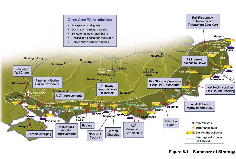
98
99 6 The Strategy at the Detailed Level 6.1 Introduction The previous chapter provided an overall summary of the strategy and its components. In this chapter we outline the nature of the elements in more detail and at the local level. Much of this work draws on work undertaken as part of the Strategy Development Plans. The Strategy Development Plans have also drawn on the outcomes of previous studies such as: the M27ITS; the Worthing-Lancing Integrated Transport Study and the Access to Hastings Study. This work is reflected in the Strategy Development Plans, which are separately published with other supporting material The chapter starts with an initial discussion on a series of broad issues, such as soft measures, the role of rail, bus, freight. These are then followed by area descriptions which highlight key problems and issues, and outline the measures in each area *. The appraisal of the strategy is given in chapter 7 and the delivery of the strategy is outlined in chapter Soft Measures A key element of the strategy across the whole of the corridor is the need to reduce the overall rate of growth in private vehicle trips. The SoCoMMS strategy recognises this by providing support to local public transport, walking and cycling initiatives, as well as support for soft measures, ie. those involving changes to local transport is planned and coordinated amongst various stakeholder groups The key recommendations for the SoCoMMS area are outlined below. Safer routes to school- these should be encouraged in many of the towns along the corridor- A variety of initiatives can be pursued locally and the types of measure adopted will be dependent on local circumstances. This approach will require the continuation/ provision of resources to local * As discussed in the Strategy Development Plans, Highway improvements are principally local in nature and are therefore also described in the latter parts of the chapter in the Strategy Development Plans. 75
100 authorities in order to develop, co-ordinate and deliver these improvements. Travel awareness education and marketing- this should be adopted across the study area. This should concentrate on providing information to users as to which services are available in key areas. This will be supplemented by up to date travel information such as at bus stops and rail stations. Improved marketing of the transport system through new and improved ticket systems should be pursued. Workplace Travel plans,- these should be expanded to encompass major employers in the corridor, and for new major developments. Government guidance should be reviewed to include targets and regional guidance strengthened regarding parking standards. Local authorities should set modal targets in congested areas and also use the introduction of workplace parking levies as a means of regulating parking spaces. This approach will require the continuation/ provision of resources to local authorities in order to develop, co-ordinate and deliver these improvements. Home working- this should be promoted nationally, as this would assist the region. This could be undertaken through the introduction of tax allowances for home offices and could form part of Workplace Travel Plans. Home Zones these should be specified for new housing developments and work undertaken to convert existing residential areas. Videoconferencing, this should be promoted through regional partnerships with local education authorities and health trusts taking a lead in its use for teaching and other purposes. Government departments could also be similarly active in the use of video conferencing. Walking and Cycling- the strategy proposes that locally based pedestrian and cycle improvements should be pursued. These include the completion of the National Cycle network and links to the network, as well as completion of local walking and cycle networks, such as feeder networks to stations, hospitals and town centres m per annum has been budgeted for the planning and administration of soft measures within the study area. It is expected that this will be focussed on creating new posts in most local authorities within the region to manage the introduction of these measures. 76
101 6.2.4 Overall, the impact of soft measures is expected to reduce travel demands by 5% during the day. In the peak periods and in particular locations, greater reductions may be achieved. 6.3 Rail Strategy The current rail system within the corridor is seen to have a number of positive features which can form building blocks for the future. In particular, the frequency of trains along the Coastway, between Havant and Eastbourne is viewed by some as being reasonable, as is the general density of station provision throughout the corridor. Similarly the introduction of new rolling stock in the corridor is viewed as positive. In addition, the four key rail routes between the south coast and London (at Southampton, Portsmouth, Brighton and Ashford (after the opening of the Channel Tunnel Rail Link ) are seen to provide a reasonably adequate basic service These positive features are, however, overshadowed by an array of real and perceived shortcomings. These will have to be addressed if the corridor s rail system is to become a first choice travel mode, rather than simply a necessary second best alternative for those who do not have access to a car It should be noted however, that the problems illustrated here are only part of the story. If rail is to function as a first choice travel mode, then whole journey issues rather than just rail based journey problems will need to be addressed. Subsequent paragraphs examine these other elements, particularly the quality of the primary station access modes (i.e. walking, cycling and public transport) and the extent to which there is seamless transfer between these modes and the train A strategy development plan has been undertaken for the potential for rail on the south coast network. This has sought to identify in more detail the range of improvements that are needed, what the timetable would look like and assess the costs and benefits of the approach. The goal is to enhance the rail system in order to support the general aims of the strategy and complement the other measures, in particular: to enhance medium/long distance east-west services to strengthen local services on the East Coastway and in Kent in the short term and in western areas in the longer term to enhance the general and presentation of the service 77
102 The elements included within this approach are: Presentation of train services Development of stations and interchanges New stations and station review Train service enhancements Infrastructure investment In developing the timetable, it is noted that in the short term there are a number of elements being pushed forward by others. These include: Implementation of schemes in GoVia (South Central) & South West Trains franchise proposals; (these will significantly improve services on the West Coastway); A new Virgin Voyager timetable for cross-country services in 2002/03; Full replacement of existing Mark 1 rolling stock by the end of 2004; The introduction of domestic CTRL services in 2007; and The introduction of new timetables for Thameslink 2000 and the New Southern Railway in The elements being proposed by SoCoMMS include: Presentation of train services: Better marketing & promotion Modernisation of rolling stock Attention to special needs (e.g. bicycles on trains) Improved quality and reliability Stations & interchanges: Improvements to station forecourts, access, short term parking, taxis, buses, interchange, kiss and ride, bicycle storage, etc. Structural improvements to station buildings, platforms, canopies, etc. New stations & station review: St Leonards Marina Glyne Gap Stone Cross Shoreham Airport Littlehampton Parkway 78
103 Eastleigh MDA - developer financed Train service enhancements: Build on existing structure with new - Fast inter-urban services - High frequency local services Enhancements - East Kent: Increase existing service from 1 to 2 trains per hour in each direction: - Canterbury West to Ramsgate - Dover to Ramsgate Increase existing service from 3 to 4 trains per hour in each direction: - Ramsgate to Margate Increase existing service from 2 to 3 trains per hour in each direction - Faversham to Dover Support Connex proposal for an increase from 2 to 4 trains between Dover & Ashford in Oct Signalling improvements Review case for a new station at Manston Airport, on the basis of local development plans (not yet agreed) Enhancements - East Coastway: Half-hourly regional express - Ashford Brighton - Southampton calling at Ore, Hastings, St.Leonards Warrior Square, Bexhill, Eastbourne and Lewes Additional stopping service between Ore and Eastbourne (going on to Gatwick and Victoria) Half-hourly local service - Ore/Brighton calling all stations via Eastbourne (in addition to existing Ashford-Brighton stopping service) Major infrastructure investment to deliver the service improvements: - Signalling enhancements - Appledore/Ore double tracking - Ore reversing facility - Provision of additional platform at Eastbourne Enhancements - West Coastway: Medium term developments Half-hourly regional express - Brighton (Ashford) to Southampton calling, inter alia, Worthing, Barnham, Chichester, Havant and Fareham 79
104 Increase from 3 to 4 trains per hour between Brighton and West Worthing Development of simplified and reliable timetable pattern with all Train Operating Companies Signalling improvements Long term developments (around 2020) Possible extension of SHRT LRT system to Southampton, or increased rail frequency between Portsmouth and Southampton Construction of Eastleigh Chord Fareham/Botley double tracking Services via Southampton Airport between Brighton and Southampton The principal output from these proposals will be a new half hourly regional express between Ashford, Brighton and Southampton. This will provide a very attractive public transport alternative to car for long distance trips on the corridor. Hastings will also benefit particularly from the proposed timetable, with three stopping trains per hour, calling all stations between Ore and Eastbourne (one of which goes on to Gatwick and Victoria), plus the two regional express services. Thus, all existing stations between Ore and Bexhill will receive five trains per hour Hastings is of particular importance to the rail strategy, as SoCoMMS has been remitted to address a number of rail enhancements proposed within the Hastings Five Point Plan. The five stopping trains per hour proposed between Ore and Bexhill compare favourably with the four per hour put forward in the Five Point Plan. SoCoMMS also endorses the need for new stations at St. Leonards Marina and Glyne Gap. The half hourly regional express service will provide enhanced accessibility both east to Ashford and west to Lewes and Brighton SoCoMMS has not endorsed the case for a new Chord at Willingdon. Whilst this will reduce journey times between Hastings and Brighton and beyond, it will result in a reduced service to Eastbourne. Most significantly, the estimated cost (over 30m) does not justify the economic benefits. The likelihood of regeneration benefits have been considered here, but the high cost and modest benefits are not judged to justify the scheme in these terms. It is, however, recommended, that this be monitored and if other regeneration issues emerge or if private sector contributions can be identified (eg: from developers) the case for the Chord could be reviewed. 80
105 Both the Regional Express and the enhanced local service through Hastings are regarded as being essential elements of the strategy. Their benefits extend beyond the transport system and include the facilitation of economic regeneration throughout the East Coastway area Indicative timetables have been prepared in the Rail Strategy Development Plan. These are based on the best available information for new services such as Thameslink It is noted that for East Kent, the introduction of domestic services on the Channel Tunnel Rail Link Section 2 (from 2007) will have a significant impact on rail journey times to London. This will significantly enhance accessibility to East Kent which is designated as a Priority area for Economic Regeneration. The potential journey times to London St Pancras could be reduced to Ashford less than 40 minutes Folkestone less than 50 minutes Dover & Canterbury less than 60 minutes Ramsgate less than 75 minutes Margate less than 85 minutes Completion of CTRL will also provide an alternative route for travellers between Hastings (and stations east of Hastings) and North and East London (e.g. Docklands) The SoCoMMS timetable has been developed without the closure of existing stations. However, there is a need to review the nature of existing stations. There are locations in the corridor where the rationalisation of stations, may increase route capacity and provide faster journey times. More detailed operational analysis by the SRA, TOCS and Railtrack are needed here. In particular, it is recommended that the case for closure of four specific lightly used stations be considered: Doleham Three Oaks Normans Bay Pevensey Bay Figure 6.1a illustrates key elements of the proposed rail strategy. 81
106 Legend New Rail Stations Possible new rail station New regional express rail services Five stopping services/hour: Ore - Eastbourne Rail frequency enhancements throughout East Kent Long term frequency and journey time enhancements: Fareham - Southampton Airport - Southampton Reading Heathrow Airport LONDON Rochester Margate Kent International Airport Ramsgate Maidstone Canterbury Salisbury Bournemouth Winchester Southampton Newport Basingstoke Southampton International Airport Cowes Fareham Ryde Farnham Petersfield Portsmouth Area of Influence Study Area Boundary Havant Chichester Arundel Bognor Regis Guildford Horsham Shoreham Airport Worthing Gatwick Airport Crawley Gatwick Brighton Lewes Newhaven Uckfield Polegate Royal Tunbridge Wells Eastbourne Bexhill Hastings Rye Lydd Airport Ashford Deal Folkestone Dover Figure 6.1a: Enhanced rail services and facilities
107 In summary, the strategic implications of the rail strategy development plan are: Significant enhancement to Public Transport service levels Long distance alternative to car, with accessibility benefits Creation of several new interchanges Sustainable infrastructure Facilitation of wider economic benefits It is recognised that the service frequency enhancements, as proposed by SoCoMMS, will increase the delays that occur at level crossings. The strategy directly addresses the issue of the Beddingham level crossing, and at other locations. Highway improvements will mean that traffic transfers away from the level crossings. However it is likely that at other sites there will be a need for infrastructure improvements or road closures. These are regarded as local issues that need to be addressed on an individual basis and through local planning and highway management process. Significant funding could be required at a number of these sites Rail proposals are described in more detail in the Rail Strategy Development Plan 6.4 Bus Strategy In overall terms there is a general consensus from the consultation that during the working day the bus services within the major south coast towns (e.g. Brighton, Southampton and Ashford) and on a limited number of inter-urban routes provide an adequate, if basic, service. Brighton & Hove and other areas of the corridor have experienced significant growth of 30% over the last 6 years. In addition, there is a perception that, where provided, specialist bus services such as park and ride, community buses and shopper buses are successful. To this end, existing bus services are well perceived in some areas and are experiencing significant growth. The strategy thus aims to build from a number of successes Key Problems- A number of issues were identified during the consultation which the strategy seeks to address: the lack of service availability in the evenings and at weekends. the limited extent to which the bus service penetrates into the community, particularly in more rural areas; the perceived high cost of travel; 83
108 the general lack of facilities, in terms of passenger comfort, passenger information; lack of bus priority schemes; public perception is that vehicles are old, dirty and unreliable Other operational issues that have been raised in connection with bus services relate to staff recruitment problems for bus companies and the lack of north-south services, through the South Downs. It has also been suggested that current competition legislation acts against the interests of integration It should also be noted that integration is regarded as a key aspect of both the bus and rail elements of SoCoMMS (as opposed to competition between these modes). Significant investment in bus-rail interchanges is included within the rail stations enhancement proposals within the rail strategy The Role of Bus Two key roles for buses are of primary importance to SoCoMMS: Provision of mobility for those groups who do not have access to a car; and Provision of a sustainable mode of transport that individuals choose to take, especially in congested areas The south east is wealthy but there are sectors of society who rely on buses such as in areas of low car ownership and social deprivation. There are pockets of social exclusion in a number of towns across the south coast corridor. Buses are also important for the elderly (the south coast has a higher proportion of the population aged over 60 than the rest of the region) and for the young who do not have access to a car Bus also has a growing role as an alternative to the car, that people choose to take, to access work, shops, education and leisure. As such bus already plays a greater role than rail in the urban areas and this is reflected in the high mode shares in Brighton & Hove, Southampton and Portsmouth In the future there is a policy imperative for increased use of bus reflected in the 10 year plan, Quality Bus Partnerships, and the Urban and Rural Bus Challenge In addition to its local role in towns, bus will be important to feed upgraded rail network and emerging light rail schemes as well as providing park-and-ride 84
109 services. In many areas, improvements in bus services are an important precursor to demand management and modal shift towards public transport. Bus can also assist in accommodating future development growth A strategy development plan has been undertaken which has sought to identify a number of improvements for local public transport. As part of this plan an analysis of bus best practice has been undertaken within the study. In general, this has referred to existing initiatives within the area. Most of SoCoMMS recommendations for buses therefore concern expanding existing programs, with proven success, across the area. The detailed elements being proposed within SoCoMMs include: Improved network planning Improved service frequencies Simplified fares, and value for money tickets Customer care enhancements, e.g. through improved training Marketing enhancements Investment in new buses Bus Priority on highways Improved passenger waiting areas Real-time information displays Traffic regulation and enforcement Park and Ride A series of corridors have been identified for improvement. These reflect those: with high population densities; suitable road capacity and traffic conditions; frequent bus services; potential developments; and which are poorly served by rail These corridors fall within 23 towns in which specific bus priority, traffic management and service enhancements have been proposed. Investment in bus priority measures, in particular, is regarded as an essential aspect of the strategy in order to overcome the growing constraints imposed by traffic congestion and to provide buses with a competitive advantage. Figure 6.1b illustrates these locations. 85
110 Reading Heathrow Airport LONDON Rochester Margate Kent International Airport Ramsgate Salisbury Bournemouth Winchester Southampton Newport Basingstoke Southampton International Airport Cowes Fareham Ryde Farnham Petersfield Portsmouth Area of Influence Study Area Boundary Havant Chichester Arundel Bognor Regis Guildford Horsham Shoreham Airport Worthing Gatwick Airport Crawley Gatwick Brighton Figure 6.1b : Enhanced bus services and facilites Lewes Newhaven Uckfield Polegate Legend Royal Tunbridge Wells Maidstone Eastbourne Bexhill Hastings Rye Lydd Airport Ashford Canterbury Proposed additional urban and rural bus services Deal Folkestone Dover Existing Interurban bus services Bus Priority/traffic managment and improved passenger facilitie
111 The recommended improvements comprise: Improvements to waiting facilities; Bus priority measures (eg: bus lanes, traffic signal measures, etc); Real time information systems; New routes and frequency enhancements, along with estimates of additional resource requirements (buses, drivers, etc); The total infrastructure costs are 26m The benefits from these recommendations include modal transfer from car for local trips and associated decongestion benefits; additional generated passengers; time savings to existing users and increased accessibility to residents of deprived areas. Significantly, many of these benefits can be delivered in the short-term and advancing these proposals should carry a high priority amongst local authorities and operators The economic NPV of this specified bus strategy is 4.9m, indicating good value for money, though the analysis has been relatively high level and will require more detailed analysis on a route-by-route basis prior to implementation The proposals generate a small operating loss (an NPV of 6.8m over the life of the strategy) indicating that a additional operating subsidy will be needed in the early years. This is estimated to amount to 1.6m in 2004, but becomes zero by This increased subsidy is regarded as an efficient public investment, helping to generate increased bus travel and paving the way for full operating cost recovery in later years Further details of the bus strategy are continued within the Local Public Transport Strategy Development Plan. 6.5 Freight The dominant freight flows on the corridor are on a north-south, rather than an east-west axis. Forecasts suggest that this will not change, although this should be subject to regular review. 87
112 6.5.2 The principal land mode for east-west freight is the road goods vehicle. The Coastway is not a major rail freight route, and it is not envisaged that this will change. SoCoMMs has certainly not identified a case for investment in an eastwest rail freight route. This aside, those freight movements which do take place, such as those serving the Dungeness Power Station, should be incorporated within future working timetables A number of north-south rail freight routes have been identified by the SRA, such as Ashford-Tonbridge-London, CTRL and Southampton-Basingstoke and beyond. These are already in operation or under development The need to cater for road freight movements, both local and regional, is recognised by the strategy. These are essential to support and develop the local economy. To this end, the various highway schemes will increase accessibility for goods vehicles. The demand management measures and soft measures will also reduce levels of congestion, particularly in peak periods, from which goods vehicles will be a particular beneficiary The SoCoMMS strategy thus aims to improve highway conditions for essential users, such as freight. A case does not exist for promoting a change of mode, for what are comparatively short hauls. For longer hauls, from the extreme east to west of the study area (eg: Dover to Southampton), the M2-M25-M3 should continue to be the designated route for goods traffic Freight Quality Partnerships (FQPs) offer the opportunity for local enhancements to the freight transport infrastructure and are regarded as an important means of upgrading facilities in respond to specific needs. A particular merit of FQPs is that they focus on local needs and involve key stakeholders in the development stage, thus increasing the likelihood of funding and delivery. SoCoMMS encourages FQPs as a means of generally upgrading freight facilities through the life of the strategy. 6.6 Role of the A259 east of Hastings The A259 provides a link from Ashford to Hastings and beyond. Currently traffic levels are low relative to the rest of the corridor (less than 10,000 vehicles per day across the Marshes). Analysis of roadside interview data shows that, at present, much of the traffic has one or both ends of its journey within the local area Key issues in this area include: 88
113 The A259 at Winchelsea, Rye, Dymchurch and New Romney is too narrow in places and the presence of traffic affects these towns. The A259 east of Hastings, particularly at Rye and Winchelsea does not have a standard typically associated with a trunk road. While the flows are low there are issues associated with the hill at Winchelsea and the route at Rye. Private vehicle travel demand between Hastings and the Kent boundary is very small at present, except perhaps during the peak of the holiday season. For this reason there are no significant capacity problems on the A259 route between Hastings and Brenzett. The road's alignment, both horizontally and vertically, combine to provide slow travel times, together with safety and environmental problems between and within the towns of Winchelsea and Rye The study has identified the need for safety and other local highway improvements on the A259 between Hastings and Ashford. These would be designed to improve road safety in this area and to ensure that the existing highway capacity is delivered The improvements should include: Renovation and strengthening of highway shoulders; Traffic control and traffic management improvements in Winchelsea and Rye; Pedestrian and cyclist measures, including refuges, guard rails and cycle lanes; Improved traffic signing, including clear goods vehicle routes; Local junction improvements, to minimise conflicting movements million has been identified for these improvements over the short term At present traffic levels, if there were a new route constructed, then transfer from the M25 motorway alone would increase flows across the Romney Marshes by 20%, without taking into account generated traffic or diversions from other routes. There are also environmental considerations. The Romney Marshes are one of the few areas on the South Coast corridor designated as being within a tranquil area by the Countryside Agency. Even if a new route were required, it would be very difficult to engineer within such a sensitive area. 89
114 6.6.7 The view of the SoCoMMs transport strategy is that if future development at Ashford has the effect of creating new travel demand from Hastings this is best catered for by improved rail services, as included within the strategy. Long distance traffic from Kent westwards should be routed via the motorway network (M2, M25, M3 etc). Nonetheless, at the local level it is recognised that current traffic activity within both Rye and Winchelsea creates safety, environment and operational nuisance there may therefore be a need to study this further, from these local perspectives. The impact of development in and around Ashford must also be monitored, particularly as the scale and location of this becomes more apparent. This may also require assumptions about highway capacity in this area to be reviewed It is also recommended that the current Route Management Strategy should examine accident issues along this section with a view to providing improvements. 6.7 Port Issues & Short Sea Shipping A separate study is being undertaken to assess a strategy for ports in the South East of England. However, to understand the needs of the port operators a series of interviews were undertaken specifically for SoCoMMS. These took place with the operators of each of the seven seaports and the Channel Tunnel Based on the problems identified through discussions with Port operators, the SoCoMMS Strategy is assisting Ports as follows: Improvements to the access to Southampton Port on the M27 and M271; Improvements to the access to Portsmouth Harbour on the M27 between junctions 11 and 12 and through upgrading of the A27 (between M27 and A3(M); Improved access to a multi-modal freight terminal at Portsmouth; Improvements to the access to Shoreham through highway improvements at Worthing, public transport improvements (LRT) between Shoreham and Brighton. It is noted that there is a separate multi-modal type study investigating access to the Harbour. Improvements to the port of Newhaven through highway improvements at Beddingham providing a much improved link to the A23 and the north, also consideration of a Lewes-Uckfield line in the future; Improvements to the access to Dover through upgrade of the A2 to dual carriuageway; 90
115 Improvements to the access to Ramsgate port through completion of East Kent access routes and rail service enhancements. In addition, a general improvement in the accessibility of these ports will support the promotion of short-sea shipping developments within the region. 6.8 Airports The Government has recently published a consultation paper on the future for aviation in the United Kingdom. The paper reviews the options for providing airport capacity over the next 30 years. The issues addressed by the consultation are: How much aviation demand should be met; Where to locate new capacity; What are the environmental impacts The South East Regional Air Services study has examined the issues in relation to airport capacity in the south east. The implications arising from the SERAS work are that none of the major options being considered directly affect the SoCoMMS area. The key issues for SoCoMMS are: Gatwick- that there is a legal agreement between British Airports Authority and West Sussex County Council from 1979 which prevents the construction of a new runway until after Thus the government has stated that it does not intend to overturn this and that options for Gatwick lie within current planning constraints; Southampton- that capacity could be upgraded to cope with 7mppa, which would require an upgrade of the runway to handle medium sized planes with additional terminal and support facilities. The 7 million passenger per annum (mppa) demand would be met if no additional capacity were provided in the rest of the South East. The forecast use of Southampton within SERAS is 3 mppa. Manston, Shoreham and Lydd fall within a second tier of airports in the region. SERAS has considered the potential demand and capacity of each airport. They conclude that Manston could have an upper limit of 3 mppa although it is noted that one of the main constraints is it s geographic location compared to the sources of demand. As such a key focus for future transport links would be local access to Thanet Way and the railway network. At Lydd an upper limit of 125,000 passengers per annum has been assumed. Lydd was also considered to be remote geographically from 91
116 sources of demand. Shoreham was assumed to have an upper limit of 500,000 passengers per annum with the key constraint being the length of the airport runway The SoCoMMS strategy is assisting airports as follows: At Southampton through the improvement in access to the airport from the M27 motorway (junction and access road) which will assist all modes of transport, the upgrade of the station to provide a major interchange hub, the provision of the Eastleigh chord which will allow access to the airport from the east. At Shoreham- through the opening of a station and the development of an interchange hub; At Manston, through the upgrade of the East Kent rail services. Should passenger demands increase substantially at Manston then consideration should be given to park-and-ride (such as from Ramsgate or Hewrne Bay), the provision of a station, or the provision of a rail link into the airport. This may be justified on regeneration grounds The SERAS report also introduces the possibility of a new airport at Cliffe in North Kent. It is likely that this will have major implications for the demandcapacity relationship of both railways and highways throughout this area. If this option is taken forward and as more details of the Cliffe proposal become known, a comprehensive review of all transport provision throughout Kent and East Sussex will be required. 6.9 National Park The links between transport and tourism were discussed in depth at the Polegate local workshop. SEERA are also preparing a draft tourism strategy. A number of factors would be important if tourism is to be encouraged without generating excessive increases in traffic. This is considered to be a particularly relevant issue given the past dependence of the area on tourism and the possible development of the New Forest and South Downs areas as National Parks The main points from this discussion are given below: In the short to medium term there is a need for education both within the tourist industry and for visitors. 92
117 The tourist industry needs to disseminate information about bus, train and taxi services to major attractions. In the short term there needs to be a partnership between public transport operators, local authorities and tourist attractions in order to reduce the impact of car use and pollution. There is also a need to introduce flexible bus routes and incentives to encourage use of rail, including introduction of lower fares for family groups and facilities to carry cycles. Proper provision needs to be made to enable wheelchair users to gain easy access to trains. Safer infrastructure and routes need to be introduced to encourage cycling and walking In the future the proposal to create a National Park encompassing the South Downs will have a significant impact on the study area. Depending on the adopted management approach, it could lead to significant increase in traffic activity within the corridor. In addition, however, it will impose much more stringent planning controls, making it increasingly important that any transport solutions are designed to minimise environmental impact The upgrade of the A27 corridor, particularly at Arundel and East of Lewes provides the opportunity for traffic to be diverted away from the National Park. For example, the upgrade of the A27 between Lewes and Polegate can reduce flows on the A259 across Beachy Head. Similarly, at the western end of the corridor, improvements at Arundel will divert traffic away from the A272 through Midhurst The SoCoMMS strategy can assist the national parks by: Diverting traffic away from the park onto designated corridors; Provide improved public transport access to the area through better rail services; Improve stations, such as at Lewes, Polegate and Arundel which can act as gateways to the park; Provide better walking, cycle and bus connections; Provide better information on services. 93
118 6.10 North South Routes Much of the South Coast study has concentrated on the east-west corridors through the study area. However, most of the towns and cities along the south coast also look towards the north for employment opportunities, recreation and business activity. The important centres that interact with the south coast include Winchester, Horsham, Crawley, Gatwick, Tonbridge and London. Good communications with these centres is therefore also important In terms of road travel there are six major corridors that generally function well. These being the M3, A3, A23, M20, A2/M2 and A299/M2 corridors. For those south coast towns that lie at the end of these corridors (i.e. Southampton, Portsmouth, Brighton, Ashford, Folkestone, Dover and Thanet) direct road based communication with London is therefore generally good. Elsewhere along the coast, communications to the north are generally poor. Such journeys either require use of unimproved roads such as the A286 (Chichester), A29 (Arundel), A24 (Worthing), A275 (Lewes), A22 (Eastbourne) and A21 (Hastings) or use of the A27 / A259 corridor to access the six primary radials In terms of rail there are major corridors to Faversham, Ashford, Brighton, Portsmouth and Southampton. Others tend to have poorer links with the north, such as from Hastings and Arundel It is important for the future of the South Coast that the northern links are maintained, and in some locations enhanced. There are crucial infrastructure links being built which will assist the area. These include: Channel Tunnel Rail Link which will provide fast services from Ashford to St Pancras. The link provides the opportunity to operate domestic services that can also serve Folkestone, Dover, Canterbury and East Kent. This will significantly enhance accessibility in this area; M2 improvements; A21 improvements, these are especially important to the regeneration of Hastings. Brighton Main line- particularly improvements at Gatwick Airport which will increase capacity, reliability on this route; A24 Horsham- Capel A3 Hindhead Tunnel. 94
119 Reopening the Lewes to Uckfield Railway It has been concluded that its primary benefit would be to relieve congestion on the parallel London Brighton railway line, particularly if the Lewes-Uckfield line were extended to Tunbridge Wells. This particular problem is outside the immediate scope of SoCoMMS and therefore it has not been investigated further It may nonetheless still warrant further investigation over time and may require consideration in the context of possible new development contained within the ESCC Structure Plan Safety Issues for RMS to consider A Route management Strategy is to be undertaken for the A27/A259 corridor. The purpose of this study is to investigate short term measures that can be applied to assist safety and operation of the corridor in the short term. SoCoMMS has undertaken an analysis of accident black spots and the results are included in the Strategy Development Plans Demand Management Measures The Role of Demand Management In the development of the SoCoMMS strategy, consideration has been given to the potential role of demand management in the future. The strategic model has been used to assess a range of alternative mechanisms such as increased parking charges, cordon charging for town centres, tolls on the motorway and trunk road network, or a form of congestion charging based on a GPS approach. The background to this work is set against forecast increases in travel demand of 28% to 2016 and 44% to 2030 in the do-minimum scenario The roles of charging in the future are : To control the overall level of traffic growth in future, particularly in relation to the private car; To encourage modal transfer where there are suitable alternatives available; and To provide revenue to fund transport improvements. Parking Demand Management Currently many local authorities have parking demand strategies. These often seek to regulate the supply and use of spaces by charging and length of stay. These may apply to local authority run public off-street spaces and in some cases, on-street spaces as well as part of an overall parking demand strategy, backed up by suitable 95
120 levels of enforcement. Local authorities have sought to increase long stay parking charges, particularly in central areas, as a means of managing demand and freeing up central spaces for short stay users. In some cases, the approach is supplemented by Park-and-ride bus services from peripheral locations. This seeks to control the volume of inbound traffic on the key radials. The Transport Act The Transport Act 2000 allows local authorities to implement charging schemes in their area for the purposes of reducing local congestion. The act also allows for the net proceeds (i.e. the revenue less any set up and running costs) of any charging scheme to be hypothecated for 10 years from its implementation in order to be spent on transport in the area. The net proceeds must be spent in support of the local authorities local transport plan, or where more than one authority is promoting the scheme, the money must be spent in support of a coherent transport strategy backed by all these local authorities. The hypothecation of proceeds is currently only guaranteed for schemes brought in within 10 years of the Transport Act When a scheme is submitted to the Secretary of State for approval it must be accompanied by a spending plan detailing how the proceeds are to be spent over the following 10 years. The options identified within the Transport Act include: Congestion charging- the focus of the legislation is very much on providing congestion relief at a local level. A local scheme can only include trunk roads if these are required to complement the aims of the local authority scheme. Workplace Parking Levy- enables local authorities to implement a licensing scheme as a mechanism for collecting a levy on private workplace parking spaces. Under the legislation, the occupier of a premises will be required to apply for a licence to park a stated number of vehicles at or in the vicinity of the workplace for those attending their place of work. This can not be used as a control on the number of car parking spaces by the local authority We have sought clarification as to whether it is possible to introduce cordon charges and workplace parking levies in the same area. The response from the DfT is that there is nothing in the Act that says this is not permitted. However, 96
121 ministers may be minded against schemes where users may be subject to both charges. Thus it is possible to have a cordon charge to cross a central area with workplace parking levies applying outside the area One area that is not covered by the legislation is in respect of out-of town retail centre parking spaces. The legislation specifically states that the workplace parking levy does not allow for customer leisure or retail parking. Therefore, if such a policy is pursued it will require further legislation, or co-operation of such centres. Proposals for Charging HGVs As part of the 2002 budget, the Chancellor announced a new distance-based lorry road-user charge, to be introduced in 2005 or The aim was to ensure that lorry operators contribute to the costs that they impose irrespective of their nationality. The Government remains committed to ensuring that the UK haulage industry does not pay any more as a result of a new charge and will at the same time introduce offsetting tax reductions for the industry Information for the South Coast Corridor shows that currently heavy goods vehicles form a small percentage of traffic on the coastal corridor. The impact of charges on the very small proportion of overseas vehicles is likely to be insignificant. Commission for Integrated Transport The Commission for Integrated Transport produced a report Paying for Road Use. They asked consultants to model different alternatives to current motoring taxes without increasing the overall cost to motorists. The approach is to shift part of the burden from taxation to a system of road user charges with the aim of delivering congestion reduction benefits for a large proportion of road users, without increasing the overall cost we pay to drive The proposal is to charge routes that are affected by congestion. The CfIT concept is dependent on a nationwide Global Positioning System with smartcard-charged units located in every vehicle. They would be able to detect where and when a vehicle was entering one of our busier roads subjected to part time charging and deduct the appropriate fee. 97
122 Overall their work suggests that congestion could be cut by 44%. It is noted that cutting congestion by 44% overall does not mean that that amount of traffic on the network would simply vanish. The results indicate that traffic levels would fall overall by about 5% and speeds would increase on average by about 3%, with greater impacts in areas suffering the worst congestion. The incidence of gridlock would also be expected to reduce significantly and reliability would improve. SoCoMMS Testing Within the SoCoMMS strategic model we have tested at 2016: Tolling motorways (at 6p/km) Tolling motorways and trunk roads (at 6p/km) Tolls within the South Downs National Park Urban Congestion charging in Southampton, Portsmouth and Brighton & Hove (based on a 2 entry charge) Tolling all links (4p/km) Increased town centre parking charges based on fee hierarchy for major and minor towns (different levels tested with 5 increase in main towns and 2 in smaller towns); Applying workplace parking levies in main and minor towns (different levels were tested) GPS charging with cordon charges and workplace parking levies- this test was used to assess the highest combination of charges to assess the impact. The test identified all links in the model with an average hour volume/capacity ratio of 0.5 (assumed to be equivalent to peak period v/c 0.75). A distance based charge was assumed for these links assuming 5.6p/km for motorways, 6.8p/km for trunk roads and 1.6p/km for rural roads The results of the tests are outlined below: Tolling motorways has an adverse impact at the Hampshire and Kent ends of the study area with diversions onto the trunk roads (A2 and A20). Although overall vehicle kilometres in the study area fall by 2%, the redistribution of trips from motorways onto other roads increases safety and environmental impacts Larger scale diversions are obtained when both the motorway and trunk road network is tolled. There is a greater reduction in overall vehicle kilometres (4%) 98
123 but vehicles also divert to lower standard routes thereby significantly increasing road safety, environmental and congestion problems on these non tolled routes A toll applied across the whole network in the south east of 4p/km was found to reduce vehicle kilometres by 5%. In this case traffic was seeking to divert onto the shortest distance routes, which were not necessarily the most desirable Imposition of tolls within the proposed National Park area has the effect of reducing usage of routes within the Park, particularly north south routes, and concentrating traffic on the primary routes (i.e. M3, A3 and A23) Urban area entry tolls, when introduced in isolation, were effective in reducing overall levels of vehicle travel in towns. They did however have the effect of increasing car use on peripheral untolled routes around urban areas (i.e. M27 and the A27 Brighton Bypass) Local tolling strategies have been found to be more effective as they directly impact on short distance trips, such schemes include distance based urban congestion charging schemes and schemes related to trip end charges (i.e. parking charges) The GPS tolls in addition to urban cordon charges and workplace parking levies reduced vehicle kilometres by 6%. The GPS on its own is providing a reduction of 3% in vehicle kilometres. The table below shows the reduction in vehicle kilometres for each of the tests. There is an increase in traffic on rural routes to the north of the corridor, particularly the A272. It is noted that in each of these tests, the reductions in trips occur with an increase in the overall cost of motoring. This is different from the CfIT approach where motoring costs increases are neutral. Reduction in veh kilometres across study area as a whole Test Motorways Trunk Other A B Road Overall Road Roads Toll Motorways -35% -1% 8% 9% -2% Toll Motorways and Trunk Roads -27% -23% 26% 23% -4% Toll all Links -9% -6% -1% -4% -5% Toll National Park 3% -2% 0% 0% 0% City Centre Urban Congestion -1% 0% 0% 0% 0% Charges Parking Charges -1% -1% -2% -2% -1% Workplace Parking Levies -2% -2% -3% -3% -3% GPS Charging with Urban Cordon Charges & Workplace Parking Levies -14% -8% -2% 2% -6% 99
124 The results of the maximum restraint test were examined to assess whether there was a need for infrastructure. On the M27, the use of the demand management is to maintain traffic levels such that wholescale widening of the motorway is not required. In West Sussex, traffic flows on the A27 are some 5 to 10% below 2016 do-minimum levels. However, at Arundel such traffic flows would still be 22% greater than the do-minimum in Given current flow levels at this location, there would still be a need for improvements. Similarly at Beddingham, traffic flows in the maximum restraint test are forecast to be 9% lower than the dominimum. However, these traffic levels are still worse than current traffic levels where there are delays. On the Selmeston- Wilmington section of the A27 traffic flows are only reduced by 1% compared to the do-minimum The key role of demand management is in the longer term to The demand management is used to cap traffic rates of growth at or below 2016 levels. Our testing showed that in the maximum restraint test, there the charge per kilometre would need to be increased by a further 50% in order to reduce 2030 traffic levels below Outcome Given the relatively short trip lengths within the study area, the SoCoMMS study has chosen locally based urban parking or congestion charging schemes. They are considered to provide a balance between affecting trip levels and the impact of traffic diverting into less suitable areas. The strategy includes: a levy on all private workplace parking spaces in core urban areas; a charge on all parking spaces in out of town retail parks along the South Coast; and car based cordon charges for entry into the major conurbations of Southampton, Portsmouth and Brighton & Hove so as to encourage use of the new Park and Ride facilities It should be emphasised that these demand management measures must be implemented in a coordinated fashion across the region (rather than as a series of discrete packages). A consistent approach to their detailed design and delivery is essential to optimising their effectiveness and the minimisation of adverse side effects. 100
125 The hypothecation of the funds from these measures within the transport system is also recommended As a final point, SoCoMMS targeted approach to demand management achieves the additional wider goals of social equity (by targeting trips for which there is an efficient, affordable alternative mode) and economic regeneration (eg.not causing widespread abandonment of socially and economically beneficial journeys). Long-term Issues Whilst the strategy covers the period to 2030, considerable uncertainty characterises the latter years. It should also be noted that planning for the years following this period must begin at least 10 years in advance SoCoMMS recognises the varied policy environment affecting transport and development and has attempted to reflect this in the strategy. This however, is subject to change as new issues and priorities emerge The principal recommendation concerning the latter years of the study period and beyond is that demographic trends, the performance of the transport system and the implications of the wider policy environment be monitored regularly. Each has implications for the relevance and suitability of particular measures So far as can be judged at this time, longer-term issues may include: Strong enforcement of land-use and development control policy to concentrate new development in those areas well served by public transport; A move away from the trend of scale economies in developments (eg: retail, education, health care, etc) at the expense of more and longer trips, towards the local provision of services on a smaller scale; The growing relevance of demand management measures, at the margin, to restrict private car use; Technological developments of traffic management systems, vehicle engines and renewable fuel sources; Technological and institutional developments of rail and bus performance management systems; Demographic trends, including a possible declining workforce as the population ages; 101
126 Changing work patterns with possible growth in home working and parttime work Whilst recognising, at the margin, the ability of the transport planning system to change aspects of travel behaviour, transport is, primarily, a derived demand. Efficient transport planning must, increasingly, work in tandem with those factors which drive demand rather than their symptoms Local Area Measures Strategy Development Plans As noted previously, a number of Strategy Development Plans have been developed to provide a more detailed analysis of some of the issues. Some of these have been topic related, covering buses and rail, which have been discussed above. Others cover a particular locality and contain further details on the multi-modal measures put forward The Strategy Development Plans have also drawn on the outcomes of various studies such as the M27ITS, the Worthing-Lancing Integrated Transport Study and the Access to Hastings Studies It should be noted that in all cases, a significant amount of further development work is required to progress these schemes. Furthermore, as noted above, no decisions have yet been taken on any of the proposals. The following pages summarise the recommendations of these local area plans South Hampshire SDP Background The South Hampshire Strategy Development Plan area covers the M27 from Cadnam to Havant. The Strategy Development Plan for South Hampshire builds on work undertaken for the M27 Integrated Transport Strategy. The SoCoMMS work has reviewed the findings of the M27 study and drawn them together into a programme for the area Key Problems and Issues- The key problems and issues identified within the area include Area is one of high car ownership Key congestion locations include M27 north of Southampton, M3 from its junction with the M27 north, M27/A27 across the Portsmouth peninsular; A32 on Gosport Peninsular and A326 at Marchwood 102
127 Flows on the M27 are approaching capacity in peaks, particularly on the sections between Junctions 3 to 7 and 9 to 12. The congestion on these sections is compounded by the local topography. The M27 motorway intersections are heavily congested in the peak periods. The section of the A27 between the A2030 and A3(M) is 4 lanes in each direction with heavy traffic flows but suffers from a large amount of weaving between traffic lanes and the presence of slow vehicles. Journey time reliability is a concern on rail lines and the road network; The area has the major ports at Southampton and Portsmouth Poor conditions for pedestrians and cyclists; Lack of integration between transport operators Poor interchange facilities at many locations Strategy Elements- In addition to the strategy wide initiatives related to green travel plans, safer routes to school, the following elements are key recommendations for the area Local Initiatives Develop coordinated management of the implementation, operation and maintenance of the transport system. There is a need to build on the current studies and initiatives being pursued; Develop local cycle network; Develop local and strategic partnerships to integrate the development of the transport system Local town centre improvements Locally based Public Transport Improvements Bus corridor improvements on A27 Corridor, Portsmouth-Waterlooville, Horndean, Southampton Totton, Southampton- Chandlers Ford, Southampton- Botley New railway station at Eastleigh MDA to serve major new development City based Park and Ride systems (initially these should be bus based but ultimately they should link into new rapid transit systems) 103
128 The proposed light rail service currently being developed between Portsmouth and Fareham Potential extension of LRT to Southampton or consideration of improved heavy rail services on Hamble line Provision of local rail services to Chandlers Ford and Hythe. More Strategic Public Transport Improvements General rail enhancements Additional passenger platforms should be provided at Fareham and Havant, A new rail chord at Eastleigh (around 2020); The line between Fareham and Botley should be double tracked. These changes will allow east-west trains to serve Southampton Parkway and thus improve access to Southampton Airport. (around 2020); Though not included in the strategy a case may exist, based on freight for loading gauge enhancements north of Southampton to Basingstoke and beyond. Access to Southampton Improvement to M27 junction 5; Upgrade of Southampton Airport Parkway as interchange hub Improve local access route to airport Targeted Road based Improvements The provision of widening between junctions 3 and 4 for operational and safety reasons the provision of a climbing lane between junction 11 and 12 for operational and safety reasons upgrade A27 between M27 and A3(M) to motorway M271 HOV/Freight lane Introduction of variable message signs, variable speed limits, CCTV and monitoring system 104
129 Junction improvements at junctions 2, 7, 8, 9, 11 and 12 for operational and safety reasons Promotion of Rail and Sea Based Freight Initiatives Encourage the use of rail for accessing the ports of Southampton and Portsmouth If Dibden Bay is to be developed, review elements required for its delivery with primary means of access (for freight) should be by rail. Portsmouth Intermodal freight terminal Promotion of freight quality partnerships Ensuring Balance In the context of providing the overall strategy, there is a need to review the management of travel demands in the future. This should be achieved by: Increasing long stay public parking charges significantly within the centres of both Southampton and Portsmouth, and to a lesser extent in the other town centres. Increasing short stay public parking charges within Southampton and Portsmouth to encourage off-peak modal transfer to public transport and park and ride. In other towns these should also be increased to some extent to encourage public transport usage. Introducing a levy on all private workplace parking spaces in the core urban areas within South Hampshire and at all out of town retail parks in the area Introducing car based cordon charges, for entry into the major conurbations of Southampton and Portsmouth so as to encourage use of the new Park and Ride facilities These demand management measures should be introduced as part of the overall strategy for the region. Released road space within both Southampton and Portsmouth should be re-allocated to public transport, cycling and pedestrians and revenues generated from the charges should be re-invested in local public transport improvements The principal elements of the South Hampshire SDP are summarized in figure
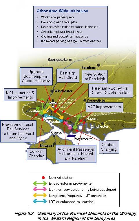
130
131 6.15 Chichester & Environs SDP Background The Strategy Development Plan for Chichester examined the future performance of the A27 and the potential for sustainable improvements between the Manhood Peninsula and Chichester Key Problems- The key problems and issues identified during the study include: extensive peak period congestion on the A27 Chichester Bypass. Congestion and accessibility problems from the Manhood Peninsula Severance as the A27 effectively acts as a barrier between the Manhood Peninsula and Chichester. This affects all users Railway level crossings give rise to delays for all road users and restrict train speeds. Safety issues on the Chichester bypass. There are serious problems, in terms of the number of injury accidents occurring at various junctions along the Chichester Bypass. Reduced bus performance due to congested network Strategy Plan for the Area -The key recommendations in addition to the areawide initiatives include: Locally based Public Transport Improvements Quality Bus Partnerships should be promoted so as to secure more frequent and extensive urban and rural bus services, particularly in the evening and at weekends Bus priority measures on the corridors between Selsey and Chichester, and Bognor Regis and Chichester Interchange facilities at Chichester should be greatly improved between bus and rail Targeted Road Based Improvements Grade separation of Fishbourne roundabout 107
132 Flyover at Stockbridge Road junction (or alternative at-grade junction modification) Close access to/from the A27 Whyke Road junction Grade separation at Bognor Road roundabout Closure of side roads at Oving Road Development of Stockbridge Bypass to improve local accessibility Review junction performance at nearby Fontwell and Slindon Common roundabouts In addition, it is likely that further improvements will be required at the eastern end of the by-pass in response to local traffic growth. This should be subject to further study The principal elements of the Chichester SDP are summarised in figure Arundel Background The Arundel bypass was one of the former road schemes that was remitted to SoCoMMS for investigation. The Strategy Development Plan has reviewed the need for a bypass Key Issues- The key issues in the Arundel area are: Congestion on the A27 at Arundel gives rise to very heavy traffic in local villages and other areas. Traffic levels on the single carriageway section through Arundel equivalent to neighbouring dual carriageway; Most A27 traffic is passing through Arundel Current flow already in excess of Highways Agency Congestion Reference Flow; Safety issues on the A27. The accident rate is twice the national average rate for the type of road and four times the national average for dual carriageways. Severance caused by high traffic flows on A27 Poor accessibility to Littlehampton; 108
133 Congestion arising from level crossings, particularly on the north-south routes; A number issues related to the perceived quality of the rail service including poor infrastructure, lack of integration Strategy Elements -In developing a strategy for the Arundel area, the following elements should be considered, in addition to the area wide initiatives: Local Initiatives New rail station at Littlehampton Parkway Improved information provision at Arundel, particularly in relation to AONB Station improvements at Arundel station- particularly to station building and forecourt, Improve pedestrian access to Arundel station; Provide additional bus connections from the station to the town centre; Provide additional bus connections from the station to the AONB. Targeted Road based Improvements Arundel bypass, with recommendation that previous preferred route (pink-blue) is taken forward Modifications to signing, particularly to Ford Industrial Estate Traffic calming on B3323 through Eastergate, Barnham and Yapton; Modification of traffic signing for visitors to Arundel; Improvements to car parks The principal elements of the Arundel SDP are summarised in figure Worthing Background- The Worthing- Lancing Integrated Transport Study investigated the need for short term measures. The Strategy Development Plan for Worthing investigated the longer term issues associated with the area, drawing upon the content of the study, as well as other analysis. Key Problems- The A27 through Worthing and Lancing carries high traffic flows. 109
134 During peak periods a number of drivers rat-run onto residential roads. 25% of traffic within Worthing / Lancing has been identified as being through traffic (i.e. both ends of the journey are outside of Worthing/Lancing). Impact on the human environment where high traffic levels in the Worthing and Lancing areas bring adverse impacts in terms of noise and air pollution Safety issues associated with the A27 through Worthing-Lancing Severance Strategy Plan for the Area- A number of proposals from the former Worthing- Lancing study have been endorsed and these are supplemented by additional local public transport measures. These should be implemented in the short term. A major highway scheme is proposed as a medium term solution. Worthing-Lancing Study recommendations Improvements to two key A27 roundabouts and a third junction using traffic signal controls Use the signal improvements to provide for pedestrians and cyclists. Traffic calming and environmental management measures on alternative routes. New service routes and service frequency enhancements on existing bus routes. Rail and Bus passenger facility enhancements and provision of real time information. Rail and Bus off-peak and weekend service enhancements. Provision of taxibus facilities at Worthing and Lancing. Improvements to station accessibility, especially for bus users, cyclists and pedestrians Complementary measures to address travel behaviour and encourage a modal shift e.g. - Green travel plans/employer travel plans - Improved travel information - Education programmes 110
135 Locally based Public Transport Improvements Quality Bus Partnerships should be promoted so as to secure more frequent and extensive urban and rural bus services, particularly in the evening and at weekends. Interchange facilities at Worthing stations should be greatly improved. Improved bus priority and waiting facilities (incorporated within local transport SDP). Targeted Road based Improvements Road improvement to A27 through Worthing and Lancing in form of tunnel or series of tunnels should be investigated. Whilst this would be a major project, environmental constraints prevent alternative solutions whilst analysis shows the value for money of a tunnel scheme to be good The principal elements of the Worthing SDP are summarised in figure Brighton & Hove Background- The purpose of the Brighton & Hove Strategy Development Plan was to review public transport improvements in the context of a major urban area. The plan sought to build upon the existing, successful, bus network Key Issues: good, popular, local bus service constrained geography, with restricted access to city congested network, exacerbated by seasonal traffic growing travel demand limited scope for further highway developments Strategy Plan for Brighton and Hove Locally based Public Transport Improvements Quality Bus Partnerships should be promoted so as to secure more frequent and extensive urban and rural bus services, particularly in the evening and at weekends Interchange facilities at railway stations should be greatly improved, particularly at the hub stations allowing interchange between local, 111
136 City based Park and Ride systems should be introduced on the outskirts of Brighton & Hove - initially these should be bus based but ultimately they will link into new rapid transit systems. A dedicated public transport system, such as LRT, should be introduced within the Greater Brighton Area, linking the centre with Shoreham, the Marina (or beyond), Falmer and Patcham The LRT would be viable (economically and with an operating profit) from around 2020, but feasibility and development activities should begin in the short term. Strategic Public Transport Improvements Local east-west rail services should be enhanced, particularly the local rail network between Portsmouth and Hastings, centred on Brighton (The Regional Express Service) Demand Management In the context of providing the overall strategy, there is a need to review the management of travel demands in the future. This could be achieved by: high long stay public parking charges should be maintained and extended within the centre of Brighton & Hove. Maintaining short stay public parking charges within Brighton & Hove at high levels, so as to continue to encourage off-peak modal transfer to public transport and ultimately to park and ride. Introducing a levy on all private workplace parking spaces in the core urban areas Introducing car based cordon charges for entry into Brighton & Hove so as to further encourage use of the new Park and Ride facilities (medum term) Released road space within Brighton should continue to be re-allocated to public transport, cycling and pedestrians and revenues generated from the charges should be re-invested in local and strategic public transport improvements The principal elements of the Brighton and Hove SDP are summarised in figure

137
138 6.19 East of Lewes Background - The area East of Lewes includes two highway schemes remitted to SoCoMMS for investigation. These include bypasses at Selmeston and Wilmington. There is also the issue of the level crossing at Beddingham Key Issues: The roundabouts on the Lewes bypass cause traffic delays. The A27 between Lewes and Polegate has a poorer standard than other parts of the corridor and doesn't work well because of the high number of side road junctions. The existing traffic signals at the A22 / A27 intersection in Polegate give rise to significant traffic delays, particularly for traffic approaching from the west. The A259, between Newhaven, Seaford and Eastbourne carries heavy volumes of traffic. This road is narrow, passes through an Area of Outstanding Natural Beauty (AONB) and suffers from a high accident rate. The A27 between Lewes and Polegate has a poor safety record. It acts as a barrier for pedestrians and cyclists, causing severance with the both the villages and towns. Major delays occur throughout much of the day at Beddington level crossing, which worsen at rail frequencies increase Strategy Plan for the Area In developing a strategy for the East of Lewes area, the following elements should be considered, in addition to the area wide initiatives: Locally based Public Transport Improvements Quality Bus Partnerships should be promoted so as to secure more frequent and extensive urban and rural bus services, particularly in the evening and at weekends New rail station at Stone Cross. Halisham Polegate-Eastbourne to become a bus priority corridor with associated bus infrastructure and service enhancements 114
139 Enhancements of rambler bus connections between AONB and Lewes/Polegate stations Targeted Road based Improvements Grade separate Beddingham level crossing, with dual carriageway standard link; Provision of Selmeston bypass Provision of Wilmington bypass Associated traffic calming The principal elements of the East of Lewes SDP are summarised in figure Bexhill Hastings Background- Hastings is a Priority Area for Economic Regeneration and the subject of considerable re-development and renaissance activity. The town suffers from both congestion and access problems. A major by-pass scheme was recently cancelled. Key Issues Journey times in the Bexhill and Hastings area are unreliable due to traffic congestion. The A259 between Bexhill and Hastings is of insufficient standard to cater adequately for demand, which results in congestion problems. In addition, the Hastings and Bexhill areas suffer from seasonal traffic problems. The Bexhill and Hastings area has a poor urban environment in certain locations due to heavy traffic flows. Urban areas of Bexhill and Hastings Child road safety is a major concern. There are significant problems with pedestrian / vehicle conflicts along Hastings seafront. Economic regeneration is a key local policy issue. The economic problems of the Bexhill and Hastings area also related to other factors, such as an oversupply of unskilled labour, shortage of available industrial premises and low rental levels which act as a constraint on business expansion. High unemployment, benefit dependency and a low wage economy also contribute to social exclusion and deprivation. 115
140 Strategy Plan for the Area In developing a strategy for the Bexhill- Hastings area, the following elements should be considered, in addition to the area wide initiatives: Locally based Public Transport Improvements Quality Bus Partnerships should be promoted so as to secure more frequent and extensive urban and rural bus services, particularly in the evening and at weekends. Several bus priority schemes have been identified within the Hastings- Bexhill area. Introduction of Green Transport Plans and Employers Plans; New rail stations should be introduced at Glyne Gap, West St Leonards and potentially at Wilting Farm. Interchange facilities at railway stations should be greatly improved. A frequent rail service (five trains per hour) should be developed, servicing all existing stations between Ore and Bexhill, going on to Eastbourne; The Regional Express (half-hourly) Ashford to Southampton service should be introduced, serving all Hastings Stations. Targeted Road based Improvements The Bexhill-Hastings Link Road should be developed Associated traffic managements in the Wishing Tree area and Guillsman Hill Consideration of a link to the A21, along Queensway, further informed by local issues Consideration of improvements on the A21 North of Hastings The principal elements of the Bexhill and Hastings SDP are summarised in figure
141 6.21 East Kent Issues Background Several SDPs have covered issues in East Kent and these are summarised here Key Issues: The capacity problems at junction 10 of the M20 affect its ability to accommodate any traffic diverted from the A259 as a result of the trunking of the A2070 and the resultant changes in signing, and the prospects for funding improvements to the interchange. There are problems on the M20 caused by 'Operation Stack' when there are difficulties at the ports and Channel Tunnel. The intersection of the A256 / A253 at Manston is congested at peak times. The single carriageway sections of the A28 at Birchington and the A253, south of Manston airport, give rise to congestion Strategy Plan In developing a strategy for the East Kent area, the following elements should be considered, in addition to the area wide initiatives Locally Based Transport Improvements Quality Bus Partnerships should be promoted so as to secure more frequent and extensive urban and rural bus services, particularly in the evening and at weekends. Interchange facilities at railway stations should be greatly improved, particularly at the hub stations outlined below. More Strategic Public Transport Improvements Local east-west rail services should be greatly enhanced, with the local rail network radiating outwards from Ashford so as to provide direct connections to London and Europe via the Channel Tunnel Rail Increase the frequency of rail services in East Kent. 117
142 A new through rail service should be introduced from Ashford, providing much improved links between this part of the study area and the central and western parts of the South Coast Corridor.This will provide direct access from Ashford to Hastings, Lewes, Brighton, Worthing, Littlehampton Parkway, Havant, Fareham, Southapton Parkway and Southampton Seamless interchange facilities should be developed at Ashford, Canterbury, Dover and Ramsgate, allowing interchange between local, through and London based rail services / local bus services / the cycle and, at non town centre stations, the private car In addition, there should be significant improvements to all stations within the East Kent area, providing greatly improved accessibility, better information and improved passenger facilities. Targeted Road based Improvements Local road improvements should be introduced on the A2, eastern approach to Dover, so as to reduce traffic congestion and environmental nuisance with Dover itself; Local road safety and environmental improvements should be introduced on the A259 as appropriate. Improvements to junction 10 on the M20. Complete East Kent Access improvements (including provision of priority lanes). Promotion of Rail and Sea Based Freight Initiatives Use of rail for accessing the existing ports of Folkestone, Dover and Ramsgate should be encouraged. In addition, depending on the future role of Manston Airport, it may additionally warrant a new rail access. When appropriate, usage of Folkestone, Dover and Ramsgate ports for coastal shipping should be encouraged, particularly for the transportation of bulky goods (building materials, etc). Promotion of freight quality partnerships The principal elements proposed for East Kent are summarised in figure

143
144 7 Appraisal of the Strategy 7.1 Introduction The aims of SoCoMMS have been to both address current and future problems within the transport network and to recommend an over-arching strategy for the area. The improvement of access to and between regeneration areas and other area of economic activity is also identified as a specific study objective Given that objectives and evaluation represent two sides of the same coin, it follows that the appraisal of the strategy should address the extent to which it meets these aims The SoCoMMS transport strategy has been appraised in line with the Guidance on the Methodology for Multi-Modal Studies (GOMMMS). There are 4 main parts to the GOMMMS appraisal process, which are: An Appraisal Summary Table (AST) which gives a summary appraisal against Central Government s five objectives for transport.; An assessment of the degree to which the local and regional objectives identified would be achieved by the strategy. An assessment of the degree to which the problems identified would be ameliorated by the strategy, compared to the situation if there was no positive policy intervention. Supporting analyses of distribution and equity, affordability and financial sustainability and practicality and public acceptability. This will also include the issue of scheme deliverability The AST is intended to be a summary of the appraisal against the Governments five objectives for transport within which there are a set of associated subobjectives: Environment; Safety; Economy; Accessibility; and Integration. 120
145 7.1.5 The AST framework also allows a direct assessment of the extent to which the specific study objectives are met The preferred strategy is designed to provide a balanced way forward, recognising the continuing need to cater for increasing travel demand (both from existing residents and new developments) while at the same time preserving the region s character. It seeks to achieve this through encouraging sustainable travel modes, recognising that there is a need to maintain accessibility by all modes of transport, so as to ensure economic vitality The following sections consider the performance of the strategy against the various elements of the GOMMMS framework, beginning with the effects on the transport network. A detailed description of the appraisal is given in the separate Strategy Appraisal Report. 7.2 Travel Patterns: Problems and Impacts The foundations of the strategy lie in reducing congestion, increasing the attractiveness of public transport, walking and cycling, thereby providing a real alternative to the car. This aim is achieved through providing: selective highway improvements; demand management measures; much improved facilities for alternative modes; increasing public transport service frequencies; improving modal interchange; and seeking to improve the quality of the traveller s environment at each stage in the journey, thus transforming the whole journey experience These measures are expected to reduce overall public transport travel times. For example, the rail journey time between Southampton and Ashford (via the Coastway) would be reduced by around one third when compared to today At the same time, the major traffic bottlenecks will have been addressed and chronic delays reduced. Travel times by road (in 15 years time) are expected to remain similar to those today Through this combination of increased public transport accessibility, combined with targeted road improvements, the strategy is expected to: 121
146 reduce the growth in car trips across the study area from 28% over the next 15 years to 20%; increase average road speeds in 2016, compared with the Do-Minimum scenario, by six per-cent; increase the rail mode share from six per-cent to seven per-cent, compared with the Do-Minimum; increase the bus mode share from six to seven per-cent across the study area; introduce LRT in Brighton with a mode share on major corridors of 23%; increase the growth in public transport usage from 30% to 50% by 2016; increase the proportion of trips with a walk or cycle element (including those also involving a public transport mode) by 15% Equally importantly, through increasing car based travel costs within the towns and cities, levels of modal transfer will be highest in the very locations where alternative transport modes are most effective and the adverse impacts of the car are greatest; ie: urban centres. Chapter 6 reported reductions in vehicle kilometres of 4% across the region with the proposed parking restraint measures The strategy will also significantly reduce current problems of personal safety and poor public transport accessibility, providing significant benefits for existing users, amongst whom are many of the most socially excluded groups within our society The results of the cost benefit analysis, below, quantify the magnitude of the strategy s impact on congestion and other network problems. In short, the strategy has addressed the identified and projected problems and developed an integrated set of efficient solutions. 7.3 Environment With or without the preferred strategy, traffic activity is set to increase considerably over the next 15 and 30 years with a consequent worsening in the human environment and in road safety (albeit that technological improvements in car design will mitigate some of these effects, as in the case of local air pollution) The preferred strategy does nonetheless offer two significant benefits over the Do- Minimum situation. Firstly, by reducing overall car usage growth, future environmental and road safety problems will be reduced. Secondly, the strategy concentrates the traffic growth in areas where it can best be accommodated (i.e. on the Motorways and Trunk Roads). 122
147 7.3.3 In terms of the human environment, problems adjacent to the M27 Motorway and the A27 Trunk Road will be higher than in the Do-Minimum situation. Away from these roads however, traffic activity will be lower. This will result in environmental benefits within the South Downs National Park and within the coastal towns On the negative side the strategy requires the construction of several new sections of highway as well as railway enhancements, new stations, park and ride sites and bus priority measures. These in themselves will impact on the physical environment. The challenge will be to provide them in such a way as to minimise this. It is likely therefore that there will need to be a commitment to paying a construction cost premium, so as to protect the environment. This is illustrated by the recommendations for a tunnel-based solution to traffic problems around Worthing The appraisal of environmental impacts has been a significant aspect of SoCoMMS and the Appraisal Summary Report should be consulted for details of this. It should be recognised that a number of the highway schemes result in a significant negative environmental impact, especially in the Landscape and Biodiversity categories. The general outcome of the environmental assessment against the principal appraisal categories is summarised below (in all cases, comparisons are against the 2016 Do-Minimum scenario): Noise: additional 129 traffic zones experience benefit; additional 1,200 of population experience dis-benefit; Air pollution: net reduction in carbon dioxide, nitrogen oxides and particulates; Landscape: large negative impact (three schemes: Hastings, Arundel, Beddingham, receiving large negative score; no scheme recording a positive score); Townscape: large negative impact (one scheme, Hastings, receiving a large negative score; seven schemes receiving a positive score); Heritage: large negative impact: (one scheme, Arundel, receiving a large negative score; no scheme receiving a positive score); Biodiversity: serious adverse impact (one scheme, Hastings, receiving a serious adverse score; no scheme receiving a positive score); Water: significant negative impact; Journey Ambience: large beneficial impact; Physical fitness: beneficial impact. 123
148 7.3.6 There may be opportunities to improve the physical environment associated with the proposed schemes. For example, reduction in traffic along certain roads may improve the townscape and landscape. In addition new sections of road that require updated drainage systems, are likely to improve the existing permanent discharges. Measures such as Sustainable Urban Drainage Systems (SUDS) can be promoted where possible, which ensure that treatment for pollutants and surface water run off meet the highest standards The Government s Ten Year Plan for Transport recognises the importance of high standards of environmental mitigation for new transport provision, for example, through incorporation of high standards of design. Opportunities for habitat creation, and integration with the landscape, townscape and heritage features of the environment, is possible through sensitive and appropriate design Throughout the appraisal process there has been continuous communication with the statutory environmental bodies, who have been given access to the detailed work that has been undertaken and opportunities to comment. It is expected that further consultation with statutory bodies will contribute to the ongoing development of the schemes As can be seen, environmental impacts of the strategy when compared against the Do-Minimum scenario involve a mix of positive and negative effects, development of the strategy has ensured that the most serious categories of negative impact have been avoided in each case. This, together with the other significant categories of benefits, has led SoCoMMS to recommend that all of the proposed schemes be included within the strategy. 7.4 Safety The package of road improvements in the SoCoMMS Strategy, coupled with reduced growth in travel demand, result in a forecast reduction in accidents of approximately 9,750 over the 30 year evaluation period, compared to the Do Minimum scenario. The number of fatal casualties are estimated to fall by approximately 230, while the overall Net Present Value is in the region of 300M. Accident values are expressed in 1998 prices, discounted to A sub objective of the Safety objective is Security. The provision of CCTV, help points, and improved lighting at all stations across the study area will help to 124
149 7.5 Economy improve personal security for all passengers that use these interchanges, therefore the strategy is appraised as having a beneficial affect on security. Cost Benefit Analysis The strategy has been evaluated using the standard Department for Transport (DfT) software for the multi-modal studies (TUBA). This calculates the economic impact of changes in travel time, operating costs, maintenance costs and construction costs, taking into account all aspects of the strategy, including the demand management measures It can be seen that the strategy performs well in economic terms and hence represents good value for money. Each significant individual element or package within the strategy also achieves a positive NPV, indicating that each item contributes towards the viability of the whole program. It should be noted that the benefits from the strategy as a whole exceed the sum of these individual components, as many synergies exist between schemes Overall Assessment User Benefits: NPV 1715M Private Providers NPV -129M Public Providers NPV 1964M Other Government NPV M Strategy NPV 1862M Strategy B:C ratio This positive NPV indicates the success of the strategy at addressing problems within the road and rail networks. It also indicates the extent of the wider social and economic benefits likely to arise from the strategy. The time and resource cost savings resulting from the measures will increase the general efficiency of the region, making it more attractive for investors and creating scope for additional social, recreational and business activities. 125
150 Wider Economic Impacts The SoCoMMS strategy is considered to generate considerable opportunities for wider economic benefits. As such, it fulfils one of the additional objectives for the study Wider benefits are likely to arise from two areas: Through the distributional effects of the strategy, for instance, the various transport and accessibility improvements in PAERs, such as Hastings; By facilitating developments and regeneration initiatives that, in the absence of transport improvements, would not take place In both cases, it could be argued that many of the wider benefits are already captured by the results of the cost benefit analysis. This is likely to be true, in part; however, the policy agenda for the SoCoMMS area puts great emphasis on the need to regenerate specific urban areas. This indicates, in economic terms, a willingness to pay exists for benefits in these areas over and above that for equivalent unit benefits elsewhere in the economy The analysis of the accessiblity impacts of the strategy, summarised below, clearly demonstrates that coastal towns and large areas of East Kent, which are designated PAERs, experience particular benefits from the strategy. Hence, the economic impacts tend to be focussed in those areas upon which economic policy is targeted The relationship between transport and development, whilst widely accepted, is more difficult to demonstrate analytically. The traffic model includes those developments (housing, commercial, retail, etc) currently proposed and illustrates the ability of the strategy to cater for these. Wider economic benefits will be derived from additional developments being facilitated by the strategy The extent to which this is likely is, to a large extent, a matter of opinion. It should, of course, be reiterated that the SoCoMMS strategy, as well as encouraging regeneration also aims to prevent development that is unsustainable and not conducive to an efficient transport and land-use system, eg: some out-of-town developments. The following points can, however, be made in this respect: 126
151 The rail service enhancements significantly improve journey times between town centres throughout the corridor, reinforcing the attractiveness of central, sustainable development sites within urban areas; Most highway measures target local congestion bottlenecks on the approaches to town centres, again increasing the relative attractiveness of urban centres as development sites for businesses; Specific urban measures, such as the Brighton LRT and Hastings Link Road, combined with the proposals for extensive bus priority schemes, will further reinforce the attractiveness of urban centres as attractive business environments; The demand management measures will confer significant benefits on essential business traffic, including goods and delivery vehicles, by reducing congestion to manageable levels In summary, many SoCoMMS measures are targeted to facilitate wider economic benefits, particularly by improving the attractiveness of urban centres (many of which are PAERs) and reducing the costs of travelling to and within such areas. This accords with the local policy agenda whilst the accessibility analysis demonstrates that the benefits from the strategy tend to be focussed within those areas for which regeneration is an important aim Reliability is also a sub- objective of the Economy objective and reflects the strategy s impact on the objective to improve journey time reliability for transport users by road and rail. Improvements to the transport networks that are part of the SoCoMMS strategy will have a beneficial effect on reliability as they enhance capacity and improve journey time reliability for road users while improved rail infrastructure and rolling stock will improve reliability for rail users. 7.6 Accessibility As part of the strategic modelling an Accessibility Model has been developed which estimates changes in transport accessibility resulting from the implementation of the Preferred Strategy. This is measured in terms of how many jobs are considered to be within 45 minutes travel time. Furthermore, accessibility is calculated by the use of deterrence functions which weight the importance of jobs by location. This means that a higher weight is placed on local jobs, and less weight on jobs which have a higher travel time Figures 7.1 to 7.4 summarise the results of the accessibility analysis as it affects regional economic performance. 127


152

153