DRAFT SCOPE OF WORK SOUTHEAST LOS ANGELES COUNTY (SR-91/I-605/I-405) FREEWAY CORRIDORS MAJOR CORRIDORS STUDY
|
|
|
- Harriet Goodman
- 5 years ago
- Views:
Transcription
1 DRAFT SCOPE OF WORK SOUTHEAST LOS ANGELES COUNTY (SR-91/I-605/I-405) FREEWAY CORRIDORS MAJOR CORRIDORS STUDY 1
2 SCOPE OF WORK Southeast Los Angeles County (SR-91/I-605/I-405) FREEWAY CORRIDORS STUDY I. PROJECT BACKGROUND AND OVERVIEW Figure 1 shows the freeway system in Southeast Los Angeles County. This portion of the county includes the Ports of Long Beach and Los Angeles. The freeway system shown in Figure 1 plays a critical role in the region s economy and well being, but also in the prosperity experienced by the state and the nation. The Ports of Long Beach and Los Angeles (the San Pedro Ports) rank third in world container sea trade and represent the nation s most important port region. Port-related truck traffic has significant influence on the existing conditions of the freeways shown in Figure 1 in Southeast Los Angeles County. Currently trucks can account for 20% or more of freeway capacity and this traffic is expected to grow substantially due to continuing expansion of the Ports, interstate freight movement, weekday commuter traffic (including car-pools) and weekend recreational traffic. In response to increasing truck volumes, an I-710 Major Corridor Study (MCS) was completed in 2005 with a local preferred strategy consisting of ten (10) general purpose lanes and four (4) separated truck lanes for that freeway. An EIR/EIS to address these improvements is currently underway. As a result of the traffic projection analyses prepared for the I-710 MCS, the cities that adjoin the SR-91 and I-605 freeway corridors commissioned a Needs Assessment for these two freeways. This Needs Assessment was completed in It showed future significant heavy duty truck volumes on most of the freeways shown in Figure 1 resulting in significant congestion when combined with future general purpose traffic and car-pools. In addition to the I-710 MCS there are other transportation studies being completed in the area in and around Southeast Los Angeles County. These include but are not limited to: 1. San Pedro Bay Port s Clean Air Action 2. I-5 EIR/EIS (I-605 to SR-91) 3. I-5 EIR/EIS (I-605 to I-710) 4. Metro/OCTA Transportation Coordination Study 5. Multi- County Goods Movement Action Plan 6. Inland Port Feasibility Study (SCAG) All of these studies could affect truck volumes on the freeways shown in Figures 1 and 2. To adequately address all the interrelated issues of transportation within the Freeway Corridors shown in figures, a regionally significant Transportation Investment study will 2
3 be prepared. This Scope of Work addresses the transportation issues for the freeway corridors shown in Figure 2. The east limit is the Orange County line and Beach Blvd. and the west limit varies from Lakewood Blvd. for I-405, Alameda St. for SR-91 and Atlantic Blvd. for the I-105. The east limit for I-405 will include the SR-22/I-405 Interchange. These limits include parallel major arterial highways to the freeways highlighted in Figure 2. II. STUDY GOALS A. To conduct a comprehensive evaluation of the overall transportation system, the results of which will be assembled into a Corridor Analysis Report and will include a Preferred Alternative; B. To prepare a Project Study Report (PSR) that is logically segmented for programming transportation projects (may be several PSRs and/or PSR equivalent documents; and C. To prepare pre-psr documentation for selected projects judged by policy makers to be of sufficient priority to require this level of analysis for agencies to secure additional funding. A Tier I environmental document, most likely an Environmental Impact Statement/Environmental Impact Report (EIS/EIR), shall also be prepared as part of the I-710 Corridor Study. The estimated length of time to complete the study is 24 months. Consultants are encouraged to develop timeliness based on experience and like studies. III. PROJECT STRATEGIES The Corridor Analysis will involve the comprehensive evaluation of the multimodal, intermodal transportation system, and this evaluation shall be generally consistent with the old format and procedures defined by the Federal Transit Administration (FTA) and the Federal Highway Administration (FHWA) for a Regionally Significant Transportation Investment Study (MIS) (Attachment 1). The PSR related activities for State facilities must be consistent with Caltrans most current format, standards, policies and procedures. Engineering plans for other elements of the preferred alternative shall provide a level of detail necessary for agencies to proceed with initiating project documents for programming. Project strategies are as follows: Address intermodal and multimodal issues to improve mobility and access needs for both commuters and freight Seek efficient ingress/egress at the Ports of Long Beach and Los Angeles and railroad facilities for cargo movement by rail, potential alternative goods movement technologies and heavy-duty trucks between the ports 3
4 and the Route 60 Freeway (the economic importance of the ports within the region, state, and nation shall be documented) Seek efficient ingress/egress at I-710 Freeway Corridor interchanges and key intersections within the study area shown in Figure 2 Develop capital-intensive, operational and technology-related solutions Develop cost-effective, short-term solutions to be implemented in near future, as well as medium- and long-term programs, policies and projects necessary for achieving significant, sustaining results. IV. OBJECTIVES 1. Provide efficient ingress/egress at the Ports of Long Beach and Los Angeles and railroad facilities between the ports and Route 60 Freeway for the freeway system shown in Figure 2 for cargo movement by rail, potential alternative goods movement technologies and heavy-duty trucks 2. Reduce passenger vehicle and truck congestion along the freeways, highway and surface streets 3. Improve mobility and access 4. Identify measures to improve safety of all modes 5. Reduce incursion of non-residential traffic into residential neighborhoods 6. Reduce air pollution, especially carbon monoxide (CO) and particulates (PM10 and PM2.5 and other air toxins), with particular regard to sensitive receptors such as residential areas, schools, hospitals and eldercare facilities V. CONSULTANT RESPONSIBILITIES The Consultant will conduct the technical work identified in tasks listed in this Scope of Work. The tasks focus on specific objectives to develop feasible alternative design concepts for improving the Freeway Corridors shown in Figure 2. Specific objectives of tasks are as described below. 1. To identify the existing and future baseline multimodal, inter transportation system performance within the Freeways Corridors, e.g., identify current and projected mobility problems and issues associated with the Freeways, local circulation, rail and bus transit, and goods movement (rail, alternative technologies and heavy-duty trucks). Travel demand forecast modeling shall be performed for personal travel and freight movements. 2. To identify and evaluate a wide range of alternatives, and propose a preferred alternative for improving freeway mainline and interchanges, major parallel and intersecting highways, transit service, bus route and service, and goods movement within the 4
5 Corridor. The preferred alternative will be a key product of the Corridor Analysis Report. PSRs/PSR equivalents shall be developed from the preferred alternative (logically segmented for programming transportation projects). Also, pre-psr documents will be prepared based on the preferred alternative identified. 3. To identify, coordinate and evaluate regional goods movement, regional transportation connectivity from the I-710 (and the Ports) to goods movement destinations inland (Northeast) of the study area. This will be performed for the other relevant studies previously listed (or other studies not listed but underway) as appropriate to ensure that goods movement transportation system are regionally complementary. The results of this Major Corridor Study shall be complementary and compatible with all the other transportation studies for adjacent or adjoining projects to provide a regionally connected transportation system. 4. To evaluate constraints associated with alternatives, such as, engineering, environmental, political, and/or economic constraints. 5. To analyze and document the right-of-way requirements of alternatives, with a primary focus to provide concept engineering plans for Freeways improvements. 6. To prepare a detailed cost estimate, and evaluate the financial feasibility, of the preferred alternative and to develop implementation strategies. 7. Provide a thorough and comprehensive evaluation of traditional and non-traditional financial strategies to fund the preferred alternative. 8. To provide a community participation and consensus building program. Tasks will also include: 9. Identifying the existing and future baseline multimodal, intermodal transportation system performance with the Freeway Corridors; 10. Identifying land use, environmental and economic development issues as they relate to the transportation infrastructure and services; 11. Identifying the livable communities issues as they relate to major transportation infrastructure and main trunk line services; 5
6 12. Ensuring that the community and public/private sector stakeholders are involved in the Study process; 13. Identifying current and projected mobility problems and issues associated with the Freeways, local circulation, transit, and goods movement; 14. Travel demand forecast modeling for personal travel and freight movements; 15. Assessing the growth of traffic and congestion at the interchanges and parallel and intersection routes; 16. Identifying community concerns and environment issues; and 17. A community participation process that will involve local community advisory committees and a corridor advisory committee to provide community participation including meetings, from the beginning to the end of the Major Corridor Study leading to community consensus for locally preferred strategies for the freeway corridors shown in figure A Technical Advisory Committee (TAC) input and participation process, including meetings of city staffs, throughout the process for the preparation of the Major Corridor Study leading toward TAC recommendations for the locally preferred strategies. 19. Assessing right-of-way availability and needs for each alternative. Tasks will also focus on: 20. Identifying design and operational constraints; 21. Establishing preferred alternatives; 22. Developing detailed cost estimated for improvements; 23. Evaluating the financial feasibility of the preferred alternatives; 24. Providing a thorough and comprehensive evaluation of traditional and non-traditional financial strategies; 25. Determining potential mitigation needs; 26. Preparing conceptual engineering plans; 27. Assessing the feasibility of intelligent transportation systems (ITS) applications and operation in the corridor; 6
7 28. Coordinating with all other relevant corridor studies/projects to ensure that analysis and results are complimentary, particularly relating to trucking issues and goods movement, transit and local circulation; and 29. Conferring with the Southeast Los Angeles Freeway Corridor Policy Committee (CPC) and elected officials to address issues and concerns. Task 1. Mobilization, Project Management, Administration The Consultant shall describe how they intend to manage and administer the Southeast Los Angeles County Freeway Corridors Study. Attachment 2 provides a partial list of standard requirements for contractors performing this type of work. This project will be managed under contract with the Gateway Cities Council of Governments (COG) in partnership (funding) and participation of Caltrans, Metro and SCAG. Within 30 days from the notice to proceed, the Consultant shall submit a Draft Project Management Plan for review, which will include: A detailed project schedule, showing the critical path and appropriate milestones. Contractor shall prepare a Project schedule showing the critical path and appropriate milestones. This schedule shall be submitted to the COG Project Manager within 30 days after award of Contract. The Project Manager prior to distribution to others shall approve any changes to the project schedule. A comprehensive quality control and assurance program. Subcontractors will be required to implement and maintain similar quality control procedures. All work will be checked and crosschecked and all deliverables will be reviewed and approved by Consultant project manager prior to submission. Independent Peer Reviews will be made during both the conceptual and final study phases. The Plan shall establish a process whereby all preliminary, review and draft reports, calculation and plans are checked for quality, completeness and readability before submittal and all job-related correspondence and memoranda are routed and received by affected persons and then bound in appropriate job files Project administration, which will address budgeting and preparation of invoices in accordance with COG requirements. A dedicated Project Administrator will be assigned to the project to ensure continuity throughout the duration of the project and to establish good communications with COG staff. 7
8 Progress reports will be prepared and submitted monthly and will be accompanied with a narrative describing the work accomplished during the reporting period, summary of meetings held and discussion of outstanding issues and action items. The reports will also include updated progress schedule, manpower and cost reports which compare actual versus planned expenditures and any concerns or significant problems with recommendations for corrective actions. The progress reports will also summarize tasks to be accomplished during the next period. The COG Project Manager will review and comment on reports via electronic communication prior to distribution to Study committees. Project meetings will be supported and assisted by Consultant in the scheduling and conduct of project/progress meetings to be conducted periodically with Study committees. Twenty-four Study committee meetings will be held with the representatives of the four (4) funding partners during the duration of this project. The meetings will discuss progress, general and specific project issues, and will be the forum for the exchange of information, resolving issues and delivering guidance and direction. Guidance and direction of the project will be received from these meetings and COG Project Management only. Consultant shall describe commitments in organizing Policy Advisory and Technical Advisory Committees (TAC). Consultant shall describe commitments in organizing the Southeast Los Angeles County Freeway Corridor Policy Committee (PC) and Technical Advisory Committee (TAC). The PC shall be comprised of elected officials, executive managers, and/or senior staff from, at minimum, Caltrans, Metro, SCAG, and the Gateway Cities COG. The TAC shall be comprised of technical engineering and planning representatives from the aforementioned agencies and organizations and will provide technical assistance and advisory input to the Study. The TAC shall also include representatives from, at minimum, staff representing the Federal Highway shown in Figure 2 Administration (FHWA), local jurisdictions along the Freeway Corridor, the California Highway Patrol (CHP), South Coast Air Quality Management District (SCAQMD), the Auto Club, trucking industry, railroads, and other interested private and public parties. Consultant shall prepare agendas for and the minutes of these meetings and forward via electronic communication for review by COG staff prior to distribution. The consultant should assume for the purpose of its proposal that the PC and TAC will meet quarterly. Community participation and meetings will be supported, assisted and attended by the Consultants. These meetings will be scheduled, coordinated and managed under separate contract by a facilitator hired by the COG. The Consultant will work closely with the community committees and the facilitator to respond to the concerns, questions and issues from the committees. The Consultant should assume quarterly 8
9 meetings of the Corridor advisory committee and bimonthly meetings of the local advisory committees. The Consultant shall submit a separate report to describe their proposed coordination with the community advisory committees. The Consultant will work with these committees to integrate their input, issues and concerns into the project (working through the facilitators) and build consensus for corridors improvements for locally preferred strategies. This draft report shall be submitted to the COG Project Manager for review, approval and distribution, within the first 30 days form the notice to proceed. Agency coordination will be supported and assisted by Consultant in coordinating and communication with all involved agencies and affected parties. Consultant will prepare minutes, reports, letters, memos an other date for MTA staff review via electronic communication prior to distribution. Contractor may establish direct contact with governmental regulatory and resource agencies and others for the purpose of obtaining information, expertise, and assistance in developing baseline data and resource inventories. The Contractor shall maintain a record of all such contacts and shall transmit copies of those records to Project Manager on a regular basis. Subcontracts will be executed and directed and work coordinated by consultant. Contract terms and conditions of the prime contract will be incorporated into the subcontract agreements. Consultant will be the primary contact for dealing with the subcontractors and the deliverables, which will be reviewed and approved by Consultant prior to submission. Project file will be developed and maintained and will be indexed in accordance with the Caltrans Project Development Uniform File System, and at the end of this contract, provide COG Project Manager with a hard copy, diskette, and acceptable electronic format of all files, presentation materials, engineering plans, and all other products described and/or implied herein). Task 1. Deliverables: 1-1. Draft Project Management Plan due within 30 days of receipt of Notice to Proceed 1-2. Final Project Management Plan due one week after any revisions to draft 1-3. Support Materials for Meetings (e.g., agendas, minutes, presentation materials, etc.) 1-4. Draft Community Participation Coordination Program 1-5. Final Community Participation Coordination Program 9
10 1-6. Support materials for Community Participation Programs (e.g., presentation materials, plans, studies, etc.) Task 2. Informal Value Analysis To initiate the Major Corridor Study, the Consultant shall perform an informal Value Analysis (VA) process at the beginning of the study. The Consultant should identify when they recommend scheduling the informal VA as soon as possible after the initial kick-off meeting so that meeting arrangements and appropriate resources obtained. The informal VA process is intended to identify all potential alternatives and reach consensus with stakeholders on initial alternatives that shall be addressed in the Corridor Analysis Alternatives Evaluation Report. Based on previous meetings with stakeholders in the Freeway Corridors, potential conceptual alternatives likely to be identified during the informal VA process will be multi-modal and intermodal and include features that may be completed in various phases for short-range, middle-range, and long-range implementation. Among alternatives identified to date, and to be considered for feasibility, are the following (or combination of the following): No Build (Baseline) Transportation System Management (TSM) (particularly Intelligent Transportation Systems (ITS) opportunities) and Transportation Demand Management (TDM) Truck lanes along SR-91, I-105, and I-605 and/or potential freight movement corridors with the study area shown in Figure 2. Input of other transportation studies on the study area shown in Figure 2 Regional connectivity options or alternative for goods movement through the study area shown in Figure 2. General Purpose lane additions along the Freeways Smart Street corridors Alternatives that include interchange concepts, operational issues, key intersection and/or roadway improvements, interfaces of travel modes within the corridor, and freight movement issues through the corridor The Consultant shall provide recommendations to COG staff for review and distribution to the Study committees for alternatives to pursue further based on results of the informal VA. The Consultant shall analyze the approved set of initial conceptual alternatives. The analysis shall include conducting a performance and benefit assessment for the conceptual design alternatives. The informal VA process shall be documented in a detailed report describing the entire process and identifying the alternatives that the VA team determined have the most viability for implementation. The report should include a complete description of all alternatives considered and how the team determined which alternatives are most 10
11 feasible. The report must be submitted to MTA staff for review and distribution to Study committee. Task 2. Deliverables 2-1. Draft Report on the Informal VA Process 2-2. Final Report on the Informal VA Process Task 3. Determine Baseline Transportation System Performance, Issues and Study Needs A. Refine Study Area The Consultant shall refine the study area and limits based upon discussion at the initial kick-off meeting. In general, the limits of the study shall be as shown in Figure 2. The Corridor width generally will be limited to the freeways highlighted in figure 2 and adjacent arterials and multi-modal interfaces with adjacent rail and bus facilities. The Consultant shall review all relevant documents and interview relevant agencies, as needed, as part of the process in determining study limits. The Consultant should clearly document rationale used in determining final study limits. B. Develop Geographic Information Systems (GIS) Maps/Data The Consultant shall prepare various size base maps for showing a wide range of information as the Study proceeds. All maps shall be prepared using acceptable Geographic Information Systems (GIS) software as determined by the Project Manager and format and all relevant data gathered for the Corridor Study shall be geocoded as overlays to the GIS base map and shall be used in performing impact analyses and evaluating alternatives (described in later tasks). In addition to GIS base maps, the Consultant shall be responsible for registering an overlay of up-to-date aerial photography that shows sufficient area around each of the freeways corridor to evaluate regional transportation, land use patterns and intermodal interfaces. In addition, the Consultant shall use an electronic copy of existing detailed topographic maps of the Freeways (to be provided by Caltrans) to show the footprint of proposed alternatives for the study. Mapping format and data shall be consistent with Caltrans standards and be comparable to a Caltrans Project Study Report (PSR), using the English system, and using same scale and accuracy as a PSR. The Consultant shall update the maps as needed to reflect current conditions and shall use the maps, in conjunction with sufficient field research, to assist in accurately estimating potential right-of-way costs, as well as impacts to the environment (including utilities) and community. C. Field Review and Compile Available Data The Consultant shall review the Study area in the field, as often as necessary to identify issues that could affect proposed alternatives. In addition, the Consultant shall research 11
12 and obtain available pertinent information and data applicable to the Study. The Consultant shall collect and review transportation/land use related reports and studies and to identify potential relevance to, and integration into, the Corridor Study. In addition to reviewing completed studies and projects, the Consultant shall review relevant studies and projects planned or already underway near this Corridor (see previous list of current known studies) and identify any gaps in the transportation planning and implementation process. A particular emphasis should be on collecting goods movement information as it related to mobility and congestion that will affect the Corridor, e.g., truck routes, restrictions, Alameda Corridor information, and data from the Ports of Los Angeles and Long Beach. Attachment 3 provides a listing of additional information that may be relevant to the Study. Copies may be available (and may need to be purchased) from sponsoring agencies. Please note that it is the responsibility of the Consultant to retrieve, review and verify the accuracy of the information received. In addition to sponsoring agencies, other agencies to be contacted for relevant information include at least the following: Other transit authorities within the corridor California Trucking Industry representatives Regulatory agencies, e.g., South Coast Air Quality Management District, U.S. Corps of Engineers, Regional Water Quality Control Board, California Department of Fish and Game, U.S. Fish and Wildlife Alameda Corridor Study representatives SCAG OCTA Metro GCCOG Using the aforementioned compiled data, the Consultant shall identify the need for any further data collection needs within the Corridor. For example, some supplemental data may need to be collected regarding truck volume data by classification for the Freeway and its interchanges, ramps, parallel and intersecting arterials and major feeder roads. Any traffic counts needed shall comply with standard Caltrans procedures for such counts. D. Evaluate Data and Determine Existing and Future Baseline Transportation System Performance Using the complied and collected data, the Consultant shall evaluate the information and determine the existing baseline transportation system performance. The Consultant shall also estimate future baseline transportation system performance for the years 2035 using available data from local agencies, Caltrans, MTA, SCAG, ACTA, The Ports and other entities, as appropriate. 12
13 The Consultant shall prepare a report that thoroughly describes baseline existing and future conditions and evaluates performance. The report shall provide a detailed description of purpose and need for the Corridor Study. Among information to be described in text and in graphics (as appropriate) should be the following: Freeway and Local Roadway Conditions Fully describe conditions and issues associated with traffic patterns and characteristics, parking, operations, safety and design issues (e.g., right-ofway constraints, physical constraints) for the mainline freeways and relevant arterials within the study area. Bus and Rail Public Transit Characteristics Fully describe characteristics and issues, such as routes, service, safety, and operations for urban and commuter rail, express and local buses, and shuttles. Support facilities, such as park-and-ride lots, shall also be described. Information shall be provided on demographics and mobility needs of the transit-dependent population. Goods Movement (e.g., Truck, Rail, Ports, Intermodal) Truck traffic is of particular concern within the Corridor study areas and considerable effort should be made by the Consultant to evaluate impacts and develop solutions relating to this element of mobility and goods movement. In addition, the following should be described to the extent that the information influences goods movement characteristics within the Corridor: Global, national, statewide, and regional goods movement characteristics and trends Major commodity origins and destinations, patterns, volumes of flow, other characteristics Rail yards, ports, major truck stops within the Los Angeles region Industrial areas and manufacturing sites within the Los Angeles region Freight terminal interfaces, intermodal facilities, forwarding centers, and warehousing centers Truck data, e.g., routes, volumes, capacity constraints, geometric limitations at intersections and on parallel routes, other characteristics Freight rail data, e.g., volumes, other characteristics Goods movement infrastructure and logistics/efficiencies of goods movement within the Corridor Significant information on cargo movement has been generated by the Ports, SCAG, Metro and as part of the I-710 EIR/EIS. The Consultant will research and use all these cargo goods movement volumes for the Corridor Study and only supplement as needed. 13
14 The Consultant shall evaluate available data compiled and provide a detailed analysis of baseline existing and future system performance that shall include at least the following: Develop appropriate performance measures for review and approval by the Project Manager and Policy Committee (PC). Listed below are desired outcomes and candidate measures or indicators of these outcomes that may be appropriate to consider as part of the evaluation process: Desired Outcomes Description Candidate Measures/ Indicators Mobility, Accessibility & Congestion Reaching desired destinations with relative ease within a reasonable time, at a reasonable cost with reasonable choices while minimizing congestion Travel Times Delay Access to desired locations Access to the system Reliability Providing reasonable and dependable Variety of travel Levels of service by mode. Time Cost-Effectiveness Maximizing the current and future benefits from public and private transportation investments. of cost Economic Well-being Sustainability Environmental Quality Safety and Security Equity Customer Satisfaction Minimize Maintenance Requirements Contributing to California s economic growth Preserving the transportation system while meeting the needs of the present without compromising the ability of future generations to meet their own needs. Helping to maintain and enhance the quality of the natural and human environment (particularly air quality). Minimizing the risk of death, injury, or property loss. Distributing benefits and burdens fairly Providing transportation choices that are safe, convenient, affordable, comfortable, and that meet customer needs. Minimizing efforts required to maintain freeway and arterial facilities as well as the maintenance Benefit/cost ratio Outcome benefit per unit Final demand (value of transportation to the economy) Household transportation costs National and state standards Accident rates. Benefits per income group Environmental Justice Customer Survey Maintenance costs Accident rates 14
15 Goods Movement needs of public transit facilities. Achieving goods movement through the Corridor Study area acceptable to local communities Efficient Goods Movement The Consultant shall develop an interview/survey form and meet with key representatives of each sponsoring, and other relevant, agency to help identify their relevant planned projects, transportation/land use issues and priorities within the corridor; to collect relevant reports, studies, and data; and to discuss potential solutions needed. Using the data compiled and collected, the Consultant shall identify existing and projected deficiencies on regionally significant roadways within the study area. The Consultant shall identify local transportation and general plan issues relevant to the Corridor Study, such as planned improvements, new or revised development plans, and existing or potential through traffic in jurisdictions within the study area. The Consultant shall identify institutional and potential environmental issues such as development/growth issues, political issues, air quality, and general plan conflicts among jurisdictions. The Consultant shall prepare a report that describes data compiles and collected in detail and summarizes existing transportation issues and problems within the study area. This report shall specifically include detail regarding freeway, local circulation near the freeway, intermodal, multi-modal, and truck-related issues. Additionally, the report should identify relevant planned projects and identify such items as scope; timing; costs; cost effectiveness; funding; safety; political issues; constraints and issues associated with design, operations, right-of-way, and impacts to the environment, particularly air quality issues, hazardous wastes, environmental justice, and overall impacts to the community; and economic redevelopment/land issues. This report shall include a purpose and need section that considers the items above in describing why a project is being proposed. In addition, per Caltrans Project Development Procedures Manual the purpose and need statement specifically should address at least the items listed below. This section will become part of the environmental document discussed in a later task. Supporting legislation Safety 15
16 System linkage Maintenance and operational deficiencies/requirements Demand exceeding capacity issues Growth and cumulative impacts Economic development Eliminate Unacceptable impacts Financial resources Task 3. Deliverables: 3-1. GIS Base Maps and Overlays (overlays shall incorporate data gathered throughout the study) 3-2. Draft Report on Purpose and Need and System Performance (to include detailed documentation on data compiled/collected and evaluated) 3-3. Final Report on Purpose and Need and System Performance Task 4. Corridor Analysis: Develop and Analyze Initial Conceptual Alternatives Results of previous tasks shall be used to develop/refine a set of initial conceptual alternatives to evaluate, and fully document this evaluation in the Corridor Analysis Report. A. Establishing Screening Criteria The Consultant will work closely with the Study Committees in establishing screening criteria by which to define and evaluate the approved initial set of conceptual alternatives. Key criteria shall include such items as the ability to relieve congestion in problem areas, safety, physical/design feasibility and issues, operational issues, right-of-way impacts, preliminary determination of air quality issues and other environmental concerns, impacts to the local community (e.g., shift problem to other communities, adds more through trips to local arterials), and preliminary costs (capital and operational/maintenance). Evaluation shall be provided specifically regarding the feasibility of truck lanes, alternative goods movement technologies, and/or HOV lanes(s), advanced technology needs, TDM applications, bus and rail public transit service needs, local circulation adjacent to the Freeways, and freight movement needs through the corridor. The Consultant shall prepare generalized, conceptual geometric engineering plans consistent with Caltrans format, standards, policies and procedures for evaluating the initial set of alternatives at a Corridor Analysis level, similar to the old FTA/FHWA MIS format. Geometric concepts should include such items as small-scale strip maps, the number of lanes, lane widths, and cost estimates in sufficient detail so cost comparisons may be made between alternatives. 16
17 B. Screen Initial Conceptual Alternatives The initial set of conceptual alternatives shall be evaluated for feasibility using the approved set of screening criteria established. Only the most feasible alternatives shall be studied further. The Consultant shall prepare a detailed report that describes the entire screening process, all the issues related to alternatives evaluated, a performance evaluation and benefits analysis of alternatives. Per Caltrans Project Development Procedures Manual, unreasonable alternatives shall be eliminated from further consideration. The Council of Environmental Quality s Questions and Answers about NEPA states that: Reasonable alternatives include those that are practical or feasible from the technical and economic standpoint and using common sense A project alternative may be rejected as unreasonable for any of the following reasons: Not meeting the project s purpose and need Economically not feasible (e.g., impact to economy if goods movement affected) Severe operational and/or safety problems Unacceptable adverse social, economic, or environmental impacts A combination of the reasons listed above, that taken individually may not be significant, but would be cumulatively significant Previously rejected at an earlier stage in project development Upon approval of a preliminary draft report by the Study Committees. The Consultant shall modify the report as needed, based on comments from the committees and Southeast Los Angeles County Freeway Corridor Policy Committee (PC) recommendations. The modified report shall become the draft Corridor Analysis Alternatives Evaluation Report. Task 4. Deliverables: 4-1. Preliminary Draft of Corridor Analysis Alternatives Evaluation Report 4-2. Draft Corridor Analysis Alternatives Evaluation Report Task 5. Evaluate Future Mobility Based on Screened Alternatives The Consultant shall estimate and evaluate the impacts of only the approved screened alternatives on future mobility within the Corridor by performing travel demand forecasting modeling. The Consultant shall meet with the Project Manager and technical subcommittee of the Policy Committee (consisting of modeling experts from Caltrans, SCAG, MTA, Gateway Cities, and the Ports of Long Beach and Los Angeles) 17
18 to discuss draft methodology report outline, overall modeling issues, sources of information, agency expectations, deliverables, etc. At least the following should be addressed when developing the methodology: Mobility along the Freeways in the study area Truck traffic along the Freeways and adjacent arterial network (within the study area, specific limits shall be defined in meetings with the technical subcommittee) Multi-modal travel characteristics (including urban rail service and bus routes/services) Alternatives considered in other modeling studies, e.g., Alternative Goods Movement Technologies, I-710 Truck Lanes) Mobility along adjacent arterial network, e.g., turn movements, etc. (within study areas, specific limits shall be defined in meetings with the technical subcommittee) Based on the above, the methodology should involve both a regional analysis based on SCAG s most current regional model to evaluate the multi-modal travel characteristics and development of a focused sub area model to evaluate local circulation within the corridor. SCAG has agreed to perform the regional analysis required for the Corridor Study. SCAG will be performing the following tasks as part of this analysis, using their new regional travel demand forecast model and Heavy Duty Truck Model: Provide regional information for base year (2005) and projected baseline transportation system for years Code regional highway and transit networks for the various approved, screened alternatives for base year and year Run model for base year and future year for each alternative. Perform all necessary post-model adjustments and analysis for each alternative and year (including air quality analysis) Prepare a report describing methodology and summarizing results, generating all summaries and analysis required, assessing impacts of the various alternatives on the regional system. The Consultant shall use SCAG s new regional travel demand forecast model and heavy duty Truck Model as the basis for developing a focused, sub area model. SCAG will provide the regional zone system, vehicle (origin/destination) trip tables as well as base year and future year highway networks (all four time periods networks and all modes of travel). The Consultant is responsible for performing all sub area model runs and must 18
19 receive approval on methodology from the Project Manager and the Policy Committee sub-committee prior to commencement of modeling related activities. Consultant shall specify software package(s) they propose to use for the sub area model. The exact east-west study limits of the focused area shall be delineated based on a consensus building process along the stakeholders within the region and, ultimately, decided upon by the Project Manager and Policy Committee. Besides the limitations imposed by funding constraints, listed below are some of the other factors that shall be considered in defining study limits: Consider an area generally shown in Figure 2 Major activity centers, trip generators and attractors Major industrial complexes, intermodal facilities, ports and other facilities associated with major truck activities Existing freeway and local network traffic congestion areas, e.g., bottlenecks, etc. Interrelationships among nearby transportation facilities, e.g., freeways, arterials, freight railroad lines, urban and commuter railroad lines, airport, as well as express and major local bus routes within the corridor. In particular, the interrelationship between the I-710 Corridor and improvements identified in the Multi-County Goods Movement Action Plan will need to be evaluated. Major planned land use development projects. The sub area network and zone system within the corridor shall provide sufficient detail to support estimation of peak hour and average daily traffic (ADT) on the freeway and local network segments, ramp locations, and key intersections. The Consultant shall coordinate with the Ports of Long Beach and Los Angeles to obtain appropriate trip tables, etc., available from a focused sub area model performed (using a previous version of SCAG s regional model) within the vicinity of the ports for their Transportation Master Plan (TMP). The Consultant shall collect 2005 (model base year) traffic counts form each respective jurisdiction in the study area for purposes of model validation and post model adjustments. The model shall be validated to match 2005 traffic count volumes at screen lines determined by the technical sub-committee. The corridor shall be evaluated for special trip generators that may significantly influence travel characteristics. 19
20 The Consultant shall perform the necessary network and zone adjustments to the regional network for the baseline, focused sub area model. SCAG has agreed to run their regional and truck models with these adjustments in order to produce compressed data. The resulting compressed data will then be provided to the Consultant for sub area modeling runs. The Consultant shall apply post-model adjustment procedures to all highway related traffic projections that are consistent with guidelines specified in the Transportation Research Board, National Cooperative Highway Research Program Report 255. Recognizing that a Users Manual for SCAG s new regional model may not yet be available for Consultant use during the sub area model development work, SCAG has agreed to provide Consultant oversight for sub area modeling tasks. Caltrans and the Policy Committee shall assume unconditional ownership of the sub area model after it is developed. Furthermore, Caltrans District 7 shall assume unconditional ownership of any new equipment acquired specifically for the Corridor Study, e.g., computer workstation, etc., upon completion of this study. Any equipment turned over to the State shall be shipped, installed, and set up to enable immediate turn key usage by State employees. The Consultant shall prepare a report to document proposed focused sub area travel forecasting methods, assumptions, and supporting analytical procedures for evaluating alternatives. The report shall be submitted for review and approval by the Project Manager and the Oversight Committee. The Consultant shall also prepare a report on travel demand forecasting results. The report shall include SCAG s regional analysis and an evaluation of the future year baseline transportation conditions with the alternatives to determine which alternative(s) provide the most benefits to the regional system. This report shall also be submitted to COG Project Manager with copies for distribution for review and approval by the Policy Committee. Task 5. Deliverables: 5-1. Draft Methodology Report 5-2. Final Methodology Report 5-3. Draft Travel Demand Forecasting Analysis Report 5-4. Final Travel Demand Forecasting Analysis Report Task 6. Evaluate Costs and Identify Potential Funding Strategies The Consultant shall compare and evaluate the costs among the screened alternatives and identify the cost effectiveness of each alternative. In addition, a detailed analysis shall be performed to identify and evaluate potential funding strategies. 20
21 The Consultant shall compare and evaluate the costs among the screened alternatives and identify the cost effectiveness of each alternative. In addition, a detailed analysis shall be performed to identify and evaluate potential funding strategies. The Consultant shall prepare a detailed report that contains at least the topics listed below: Identify costs associated with each element of each alternative (e.g., Highway Element, Rail and Bus Public Transit Element, TSM/TDM Element, etc.), using standard methodologies employed by Caltrans for calculating costs. Estimated capital, operations, and maintenance costs should be clearly identified. A detailed cost/benefits analysis and cost effectiveness among alternatives shall be performed. An in-depth analysis that thoroughly reviews funding opportunities and challenges through potential traditional and non-traditional funding sources. The analysis should describe potential funding sources for various elements of each alternative and discuss the applicability and feasibility of these various funding sources for implementing the alternatives. The analysis should also include a detailed evaluation of existing and proposed sources of revenues and a cash flow analysis. The Consultant should consider funding strategies in which implementation of alternatives is phased over time; portions that could be funded and implemented within the near future, within the next ten (10) years, and describe elements that may not be fundable until the 2035 or later. Identification of requirements for applications for local, state, and federal funds. This report shall be submitted for review and approval by the Project Manager, with input from the Study committees. Task 6. Deliverables: 6-1. Draft Report on Cost Evaluation and Financial Strategies 6-2. Final Report on Cost Evaluation and Financial Strategies Task 7. Tier I Environmental Document The Consultant shall prepare a Tier I level environmental document, an environmental impact report/environmental impact statement (EIR/EIS) for the screened alternatives. The environmental analysis shall be in conformance with current requirements of the California Environmental Quality Act (CEQA), the National Environmental Policy Act (NEPA), as well as with Caltrans, FHWA, and Corridor Study guidelines and 21
22 requirements. Proposed Consultant products shall include, but not be limited to at least the following: Preliminary Draft Environmental Evaluation Final Preliminary Environmental Evaluation Notice of Preparation (NOP), Notice of Intent (NOI), and Notice of Initiation of Studies (NOIS) Screencheck Draft Tier EIR/EIS (a preferred alternative shall be identified at this stage in the environmental process, see next task) Draft Tier I EIR/EIS Response to Comments Prepare Draft/Final Relocation Study Final Tier I EIR/EIS Notice of Determination/Record of Decision (ROD) Public Hearing Announcements, Presentation Materials, and Record of Meeting The level of analysis shall be based on requirements for Tier I environmental document; it is assumed more detailed environmental analysis will be needed at a later stage in the project development process (not included in this contract). Please note that among the specific products and studies that shall be part of the environmental analysis for the Corridor Study are the following: Area of Potential Effects mapping Floodplain Evaluation Report Air Quality Report Traffic/Circulation Impact Report Hazardous Materials/Waste Initial Site Assessment Visual Impact Assessment Report Noise Report Archaeological Survey Report Historic Architectural Survey Report Historic Property Survey Report Wetlands Delineation and Special Biological Surveys (if needed) Relocation Impact Study 22
23 Environmental Justice Analysis and Demographics (please note that this is a particularly important section for the I-710 Corridor Study) All products developed in this task shall be reviewed and approved by the Project Manager, with input form the Study committees. Task 7. Deliverables 7-1. Preliminary Draft Environmental Evaluation 7-2. Final Preliminary Environmental Evaluation 7-3. NOP, NOI, and NOIS 7-4. Screencheck Draft Tier I EIR/EIS 7-5. Draft Tier I EIR/EIS 7-6. Response to Comments 7-7. Prepare Draft/Final Relocation Impact Study 7-8. Final Tier I EIR/EIS 7-9. Notice of Determination/Record of Decision (ROD) Public Hearing Announcements, Presentation Materials, and Record of Meeting Task 8. Prepare Geometric Engineering Plans and Cost Estimates for Screened Alternatives A. Formal Value Analysis A formal VA will need to be performed, consistent with Caltrans most current policies, procedures and guidelines. The Consultant should identify when they recommend scheduling the formal VA as soon as possible after the initial kick-off meeting so that the Study may be added to the State-wide VA program and appropriate Caltrans staff resources may be scheduled. B. Preferred Alternative Development Based on results of previous tasks, the consultant, under the guidance of the Project Manager and the Technical Advisory Committee, shall develop a preferred alternative. This may consists of one or a combination of the previously evaluated alternatives. At least the following shall be included in the report: Detailed evaluation of screened alternatives and a description of the issues relating to how the preferred alternative evolved, why this alternative was selected. Matrix of all elements of the preferred alternative (e.g., proposed infrastructure, service, and operational improvements as they relate to the freeway mainline and interchange improvements, rail and bus transit, goods movement, etc.) and key issues influencing implementation, etc. 23
24 Matrix showing estimated project cost estimated for each element of the preferred alternative, funding status, implementation status (e.g. potential for near-term, medium-term, or long range implementation), potential funding options A consensus building process will commerce at initiation of the preparation of the geometric plans with the community advisory committees and the Technical Advisory Committee. This will be managed (or facilitated) under a separate contract with another consultant. However, the Consultant shall provide support at all meetings for presenting the proposed strategy to the Study committees and other meetings, to solicit comments, reviews and consensus. The Consultant shall add results of the consensus building efforts to the draft Corridor Analysis Alternative Evaluation Report review and approval by the Project Manager and the Policy Committee. C. PSRs/PSR Equivalent Documents Using the proposed projects identified within the preferred alternative, the Consultant shall develop cost estimated and other criteria necessary to assist the Project Manager and the Study committees in determining for which of these projects the Consultant shall proceed in preparing PSR and/or PSR equivalent documents. All aspects of preparing the PSR level programming documents shall be done in accordance with current policies, procedures, practices, standards, guidelines, and regulations that apply to Caltrans project development process for state facilities and the comparable process for local projects. It is estimated that approximately one-fourth of the Study budget will be used for developing the PSR(s) and/or PSR equivalent documents that is/are logically segmented for programming transportation projects. The engineering analysis shall include interchanges within the Study area, as well as all undercrossings and overcrossings. Consistent with Caltrans PSR requirements, concept geometrics shall include developing cross sections, preliminary staging plans/detours, strip maps, right-of-way requirements, and rehabilitation strategies. Some basic design features that must be identified include the following: Land width, shoulder width, and bridge width Design speed Cross slope Grade Superelevation Stopping sight distance Horizontal and vertical alignment Horizontal and vertical clearance Bridge structural capacity 24
25 The concepts shall be to full design standards, but also consider non-standard specifications where appropriate (the Consultant shall prepare a Caltrans fact sheet for non-standard specifications) and should be illustrated by cross sections and drawn on photogrammetric base mapping where the edge of pavement and approximate right-ofway lines shall be shown. In compliance with Caltrans procedures, a structure Advance Planning Study shall be conducted for freeway alternatives that would require modification and/or construction of structure(s). It is anticipated that some of the conceptual engineering analysis will already be available for arterial related improvements from previous studies, such as the work performed for MTA/SCAG in their Southeast Sub-Regional Traffic Signal System Coordination Project. For arterial alternatives not directly with the Freeways, analysis shall merely supplement available data. Please note that proposed improvements for major parallel arterial facilities will be staged to occur prior to Freeway infrastructure enhancements so that these roads may serve as key detour routes in the proposed Transportation Management Plan the Consultant shall be developing for the preferred alternative to mitigate traffic congestion during freeway construction activities. The Consultant shall prepare a detailed preliminary draft report that describes the entire process of identifying the initial set of conceptual alternatives, establishing screening criteria, screening initial conceptual alternatives, and all information developed for alternatives. Key transportation elements for each alternative, and underlying assumptions, shall be clearly described. The report should also include a detailed performance and benefits assessment of all alternatives considered. Upon approval of the above preliminary draft report by the Study Committees, the Consultant. This shall modify the report as needed, based on their comments and the Corridor Policy Committee (PC) recommendations. The modified report shall become the draft Corridor Study Alternatives Evaluation Report to be finalized later in the Corridor Study. D. Cost Estimates The Consultant shall prepare cost estimated for the preferred alternative as required for PSR development. Cost estimates shall be based on such costs as those identified from preliminary engineering plans, structure cost estimates, and costs associated with rightof-way, utility, and railroad impacts. The procedure outlines below shall be followed to the extent feasible for cost estimates relating to right-of-way, utility relocation assessment, and railroad impacts for the alternatives. 25
26 The estimator(s) must be qualified and these qualifications must be clearly described in detail in the proposal and will be subject to approval by Caltrans District 7 s Right-of-Way (R/W) Division. The proposal shall include a detailed description of the methodology the Consultant proposes to employ in formulating cost estimates, a list of their experience with estimating R/W, utility, and railroad costs for major capital projects, and a list of references for previous estimating work. In particular, the Consultant shall describe their approach in determining when parcels would be considered as full take versus partial takes. The proposal should include a sample of the work sheet and estimates performed previously for major projects. The proposal should include a list of sources of information typically used when developing the type of cost estimated needed for the Study and how the data will be applied to this Study. Please not that the estimates must be based on individual units, and not clusters of units, unless written the R/W Division for this approach gives approval The estimator s work must be in acceptable format and in compliance, and conformance with current applicable State standards, practices and procedures. To facilitate this, a meeting for the Consultant estimator(s) with the Study Project Manager and the appropriate R/W management and staff shall occur prior to the commencement of cost estimate tasks. Objectives of the meeting shall be to establish Consultant expertise, discuss Caltrans issues and concerns, and to agree upon the logistics for samples of work to be periodically, and randomly, evaluated by Caltrans R/W staff. Cost estimates must be completed in accordance with the most current, updated version of the State R/W Manual (including the most recent R/W Manual Change Transmittal ) and federal regulations. The Consultant shall provide a R/W Data Summary for submittal, review, and approval by Caltrans District 7 s R/W Division and any revisions needed shall be at the consultants expense. The Consultant shall also provide excel worksheets (both electronic and hard copy format) that clearly identify details regarding each potential property cost estimate. Color, digital photographs (clearly labeled with address information and in both an acceptable electronic file and hard copy format) shall be provided of each potential property take. 26
27 Mapping showing R/W data shall include the following: Proposed improvements Property ownership Assessor s parcel numbers (APNs) Size of each parcel Proposed R/W lines Access control Easements (permanent & temporary Significant property ingress modifications Utilities Railroad facilities The Consultant shall provide support, as needed, in presenting the corridor analysis, preferred alternative and PSR information to the public and shall modify the Draft Corridor Analysis Alternative Evaluation Report (to become the Final Corridor Analysis Alternatives Evaluation Report) and the Preliminary Draft PSR(s) as needed, based on public comments and Study committees recommendations. The modified Preliminary Draft PSR(s) shall become the Draft PSR(s), and upon final approval by the Project Manager and the Oversight Policy Committee, the Draft PSR(s) will become the Final PSR(s). E. Pre-PSR Documentation Recognizing that the Study does not have sufficient funds to prepare PSR/PSR equivalent documents for each improvement proposed within the preferred alternative that requires this type of programming document, the consultant shall perform a less detailed, initial analysis of selected projects that have been judged by policy makers to be of sufficient priority to require this analysis. The intent is to perform an intermediate level of analysis that provides agencies with enough information to secure additional funding to perform the PSRs/PSR equivalent studies and begin the project development process. It is estimated that approximately five (5) percent of the Study budget will be used for developing pre-psr documents. The documents may become fact sheets that include at least the following information: 27
28 Brief project description and scope (location, termini, proposed actions, anticipated environmental document requirements, etc.) Project need and purpose (e.g., how project would impact mobility, air quality, etc.) Project costs (e.g., construction costs as well as the project development documents such as PSR/PSR equivalent document, environmental documentation/engineering design plants, etc.) Potential implementation schedule The consultant shall prepare a draft of the documents described above that shall be reviewed and approved by the Project manager and the Oversight Policy Committee. The Consultant shall incorporate proposed revisions into a final version of these documents. Task 8. Deliverables: 8-1. Revised Draft of Corridor Analysis Alternatives Evaluation Report 8-2. Final Corridor Analysis Alternatives Evaluation Report 8-3. R/W Mapping, Data Sheets and Worksheet Information 8-4. Draft Engineering Plans and Cost Estimates for PSR(s) 8-5. Preliminary Draft PSR/PSR equivalents 8-6. Draft PSR/PSR equivalents 8-7. Final PSR/PSR equivalents 8-8. Draft Pre-PSR documents 8.9 Final Pre-PSR documents 28
29 SCOPE OF WORK SOUTHEAST LOS ANGELES COUNTY FREWWAYS CORRIDOR STUDY ATTCHMENT 1 REGIONALLY SIGNIFICANT TRANSPORTATION INVESTMENT STUDY GUIDELINES The following pages represent a composite of typical topics evaluated in a Regionally Significant Transportation Investment Study (RSTIS). It is recommended that the Consultant review this list and incorporate, as appropriate, topics to include in proposal packages for the Corridor Study (Based primarily upon, Training Program on Major Investment Studies, August 1996, prepared for the Federal Highway Administration and Federal Transit Authority by National Transit Institute and Parson, Brinkerhoff, Quade & Douglas, Inc. Some topics were modified to provide a stronger focus on specific issues relevant to this Study) Inventory & Issues I. Transportation Facilities And Services A. Travel Patterns for Public Transportation and Highways (Forecast year projections and comparison with current patterns) 1. Trip making (number of trips, purposes, orientation, lengths) Work trip attractions from the corridor to downtown/suburban areas Extent of reverse commuting Non-home based travel between activity centers 2. Mode of travel (automobile, bus, rail, airplane) Local Vs. Regional trips Work vs. Non-work captive vs. choice riders (bus or rail) Tourist related trips Goods Movement B. Public Transportation 1. Operating characteristics Coverage and hours of service Route structure Roadways Load factors 2. Levels of service Geographic coverage Hours & frequency of service Travel times for selected interchanges and street intersections 29
30 Accessibility measures Transferring Reliability 3. Transit ridership Corridor-wide Selected lines To selected destinations 4. Revenues & operating deficit Fare structure, average fare, and total revenues Operating costs and deficit Stratification s by service type (bus/rail, local/express) or jurisdiction C. Highways (freeway and arterial street system) 1. Physical characteristics (alignments, number of lanes, capacities, etc.) 2. Traffic volumes and levels of service Identify by total as well as by types of vehicles (including trucks) 3. Volumes of key facilities/links Volume to capacity ratios Levels of service and duration Travel times for selected interchanges & intersections Impacts of transit vehicle & truck operations on highways (freeway and local) D. Parking 1. Park and ride lots (current & planned lots, demand & capacity, etc.) 2. Business parking supply & price (downtown & other key locations) 3. Adequacy of existing/projected parking demand E. Freight/Intermodal Goods Movement Information on various topics below is available from the Ports of Long Beach and Los Angeles through their Transportation Management Plan (TMP): 1. Travel Patterns & Mode Split (ports, rail, trucks, airport) a. Port and non-port truck trip travel patterns and hours (e.g., eliminate need for trucks to travel during rush hours, decrease the need for illegal commercial vehicle parking) b. Capacity constraints/networks limitations 30
31 c. Design constraints d. Operations/Maintenance/Safety Issues e. New technology implementation issues f. Electronic Data Interchange (EDI) g. Automated Vehicle Identification (AVI) i. Air quality standards may force new emission control technology, engine designs, & alternative fuels without sufficient time for development & testing. j. Funding for maintenance & upgrading of equipment & computer software of weigh-in motion bypasses is inadequate. k. Global Positioning Systems (GPS) l. Implementation of commercial vehicle/international border enhancements may be hampered by institutional breakdowns between Federal, State & Mexican governments m. Larger capacity & longer-range aircraft may result in air cargo carriers choosing airports outside of California for their overseas operations. n. Implementation of automation technology enhancements, including, navigation surveillance, weather prediction system improvements & air traffic controller aids is hampered by funding constraints. 2. Determine Commodity Type by Weight, Volume and Value 3. Access to Intermodal Facilities (Use data provided by Ports to evaluate access issues, e.g., feasibility of truck staging areas, etc.) 4. Ports of Los Angeles & Long Beach TMP TMP s estimates for projected truck trips Intermodal connections 5. Long Beach Airport Ground access Freight railroads (e.g., alameda corridor_ 6. Trucking & deliveries Information on various topics below may be available from an empty ocean container logistics study: Availability of curb parking/delivery lanes Potential for relocating or rescheduling Feasibility of truck lanes Truck traffic levels Safety Efficiency 31
32 Link of ports of San Pedro Bay, major regional airports, industries, warehousing areas, freight consolidation, gateways to major highways Promotion of urban infrastructure to facilitate efficient truck movement Assessment of current impediments to cargo transport 7. Potential of and Market of Intelligent Transportation Systems F. Other Elements of Transportation 1. Nonmotorized Transportation Bicycle lanes/paths Pedestrian friendly & accessible (e.g. supports livable community concept) 2. Transportation System Management/Transportation Demand Management 3. Rehabilitation & Maintenance of Existing Facilities 4. New Technology G. Transportation Plans 1. Local & regional improvements planned for the corridor (both highways & transit) 2. Short range, medium & long-range strategies for the corridor II. Affected Environment, Analysis and Consequences A. Visual & Aesthetic Features 1. Sensitive scenic resources, e.g, skyline, mountain vistas, ocean view 2. Description of areas where significant and incompatible visual changes would occur in close proximity with existing uses (residential, parklands, etc.) 3. Views interrupted by new transportation facilities Identify visual changes Identify affected land uses Mitigations 4. Views from the new/improved transportation facilities B. Land Use and Economic Activity (forecast year projections and comparison with current patterns) 1. Regional Summary Existing land use patterns 32
33 Trends in populations, employment, and economic activities Historical absorption rates and trends for office, retail, and residential development 2. Study Area Existing land use patterns Major activity sites Land use plans, policies, and controls Distribution of socio-economic characteristics Trends in population, housing, employment, and economic activities Historical absorption rates and trends for industrial, office, retail and residential 3. Neighborhoods Historic development Demographics (age, composition, income) Sense of community Community resources (school, centers, community stores, etc.) Location of neighborhoods relative to transportation improvements Changes in quality of life (based on transportation improvements) Displacing and land use changes Traffic and parking Noise and vibration Visual or physical intrusion of new transportation facilities Mitigation Barriers to social interaction (community fragmentation Safety and security Transit operations Auto traffic Crime associated with transit stations Mitigations 4. Business Major trip generators and attractions Types of business (existing, proposed) Feeding into existing blight areas, brown fields, & outmoded facilities that are planned for major redevelopment Other targeted major redevelopment areas 5. Land Use Impacts Regional 33
34 Corridor Station areas Joint development 6. Impacts of Land Use Change Consistency with planning and zoning Services and tax base Traffic and parking 7. Displacement and Relocation of Existing Uses Displacement Number of units affected Characteristics of affected households Business uses Size and type Number of employees Effect on the community Public facilities and land Transportation, communications and utilities Use of vacant land 8. Relocation Availability of relocation opportunities Description of relocation assistance that would be offered Financial assistance Equity participation Advisory services Timing C. Air Quality 1. Relevant Pollutants Summary of important transportation-related pollutants (CO, HC, NOx, PM10, PM2.5, and other air toxins) National Ambient Air Quality Standards (and State standards, if applicable) 2. Regional Compliance with Standards Attainment status of the region Summary of relevant transportation Control Measures from the State Implementation Plan Air Quality trends based on monitoring data & growth projections Changes in emissions with project implementation Microscale Carbon Monoxide Impacts - Line source (freeway and highway network) - Point source (park/ride lots, critical intersections 34
35 Conformity with the State Implementation Plan 3. Identification of Sensitive Sites Criteria for identification Description of sites Results from the monitoring program D. Ecosystems 1. Existing Wildlife in Potentially Affected Areas Summary of native wildlife Threatened and endangered species Critical habitat Wildlife and waterfowl refuges and habitat (potential for fragmentation) 2. Existing Vegetation in Potentially Affected Areas Summary of major plant communities Extent of vegetation throughout the Study Area Rare and endangered species 3. Assessment of Impacts to Flora and Fauna Identify species potentially impacted and degree of impact Describe coordination with resources agencies Results of biological assessment (if needed) Mitigation E. Water Resources 1. Surface Water Identification of beach area, rivers, culverts, etc. Current water quality and state and federal standards 2. Groundwater Location of aquifer recharge areas Significance 3. Floodplains Location and geographic boundaries of 100-year floodplain Function (support wildlife, plants, open space, outdoor recreation, agriculture, forestry, groundwater recharge, etc.) Importance of each function Existing development and controls 4. Wetlands Location and geographic boundaries 35
36 Function (flood control, erosion control, wildlife habitat, recreation, etc.) Importance of these function 5. Impact Assessment/Mitigation Water quality (turbidity, sedimentation, chemical pollutants, biota) Consistency of water quality with state/federal standards Likelihood of aquifer contamination Impacts on floodplain functions Changes in risk of flooding Extent to which various transportation improvements may directly or indirectly induce floodplain development Mitigation F. Energy 1. Identify potential impacts on energy consumption 2. Describe impacts, conservation potential of project implementation G. Hazardous Wastes 1. Identify hazardous waste sites 2. Describe how these sites will be cleaned, etc., impacts, mitigation H. Geotechnical 1. Describe geotechnical characteristics of the study area 2. Identify issues, impacts, mitigation I. Historic & Archeological Resources 1. Applicable Legal and Regulatory Requirements Description of national historic preservation process Description of efforts to identify resources 2. Description of Resources in the Area of Potential Effects (site-by-site discussion) Description of the resources Status of the resource with respect to the National Register Location relative to the transportation improvements 3. Description of Likely Impacts on Historic Sites 4. Mitigation J. Parklands 1. Applicable Legal and Regulatory Requirements Summary of Section 4(f) process Section 6(f) requirements 36
37 2. Description of Potentially Affected Sites (site-by-site discussion) Size, owner, and location of boundaries Function or use of the parkland Access to the site and level of use Proximity to transportation improvements 3. Likely Impacts to Parklands 4. Mitigation K. Noise & Vibration 1. Noise Criteria for the Proposed Transportation Improvements Local noise ordinances DOT/HUD/EPA guidelines APTA guidelines 2. Ambient Noise Conditions in Study Area Identification of sensitive areas Criteria for selection of monitoring sites Ambient noise levels at sensitive sites Characterization of noise levels in surrounding areas 3. Noise and Vibration Assessments Summary of method used in assessing noise and vibration Estimated noise and vibration levels Mitigation L. Impacts/Mitigation During Construction of Transportation Facilities 1. Transportation and Circulation 2. Displacements, Relocation and Restricted Access for Existing Land Uses 3. Neighborhoods 4. Air Quality (from construction and detours) 5. Noise and Vibration 6. Water (runoff during construction, permits needed) 7. Ecosystems (if impacted during construction) Proposed Strategies, Programs & Projects I. List of Recommendations for Transportation Improvements A. Intermodal & multi-modal solutions B. Improving mobility & access for people & freight C. Improving ingress/egress 37
38 D. Reducing congestion E. Improving safety of all modes F. Reducing air pollution G. Reducing incursion of non-residential traffic into residential neighborhoods II. Funding Considerations for Transportation Improvement Recommendations A. Proposed Costs (and Potential Revenues) Associated with Each Improvement 1. Initial capital costs 2. Potential operating & maintenance costs 3. Operating revenues Transit farebox and nonfarebox operating revenue sources Highway toll and non-toll operating revenue sources B. Proposed Schedule for Implementing Improvements 1. Near term projects 2. Medium term projects 3. Long range projects C. List by Type of Investment and Potential Funding Sources 1. Proposed capital intensive investments 2. Proposed operational improvements 3. Proposed technology related solutions 4. Potential funding sources (for planning and/or capital phase) Local agencies Regional agencies State agencies Federal agencies Private sector funding sources User fees Transportation tax measures Evaluate Recommendations 38
39 A. Perform a Cost/Benefit Analysis 1. Identify/discuss trade-offs 2. Measures of effectiveness 3. Cost-effectiveness analysis 4. Financial Feasibility 5. Equity 6. Include public views regarding various options B. Compare environmental impacts (Overall impacts of transportation improvements on environment) Community Participation to Build Consensus Throughout the Study preparation process, community participation will be a key element to review all Study activities and receive input regarding transportation problems and proposed solutions. 39
40 SCOPE OF WORK SOUTHEAST LOS ANGELES COUNTY FREEWAY CORRIDOR STUDY ADDITIONAL REQUIREMENTS ATTACHMENT 2 The Consultant shall conform to the following Terms and Conditions and/or requirements in executing the scope of work for this contract: The data, documents, reports, plans and estimates will be reviewed by COG for conformity with SCAG Design Standards and other applicable guidelines, policies and procedures. Reviews as stated above do NOT include detailed review or checking of design of major components and related details or the accuracy with which such designs are depicted on the plans. The responsibility for accuracy and completeness of such items remains solely that of Contractor. Contractor or its subcontractors shall not incorporate in the design materials or equipment of single or sole source origin without written approval of Project Management. Technical reports and studies shall include, but not be limited to, advance planning studies, geometric design alternatives, traffic reports, materials information, hazardous waste site assessments, conceptual preliminary alternative reports, preliminary environmental reports, and fact sheets. The page identifying prepares of engineering reports and each engineering drawing, shall bear the professional seal, certificate number, registration classification, expiration date of the certificate and signature of the professional engineer(s) responsible for the preparation. Environmental reports not requiring engineering service need not be so identified. Contractor shall designate a Surveys Manager who will coordinate the Contractor s surveying operations. The Surveys Manager shall be responsible for all matters related to the Contractor s Project Manager. Contractor shall apply for an Encroachment Permit prior to entering the State Highway right-of-way for field checking of existing conditions or for any other purpose. The Encroachment Permit shall be issued to the Contractor by Caltrans at no cost. All elements of the project shall be considered for least cost alternative analysis (value engineering) throughout the development of the PSR. Also, Contractor to include in the PSR an incremental cost/benefit analysis for the various proposed improvements. Contractor to prepare a minimum project alternative and identify modular segments. Contractor shall implement and maintain the following quality control procedures during the preparation of reports and documents relating to this Project. Contractor shall have a quality control plan in effect during the entire time work is being performed under the project contract. Evidence that the quality control plan is functioning may be requested by local or state officials and Project Management. 40
41 Contractor shall maintain a set of project files, which shall be indexed in accordance with State s Project Development Uniform File System. Contractor shall establish a local office within 30 miles of downtown Los Angeles County or will make other acceptable arrangements to facilitate review of the Contractor s work by Project Management and insure accessibility of interested local agencies and the public. 41
42 SCOPE OF WORK SOUTHEAST LOS ANGELES COUNTY FREEWAYS CORRIDOR STUDY ATTACHMENT 3 Information that may be relevant to the I-710 Study includes the following list: Studies, reports completed, underway or planned. Examples include the following (scope of work includes other relevant studies): - Truck lane feasibility studies - SCAG s, Potential Terminal Island Freeway-San Diego Freeway Connector and other relevant SCAG studies - MTA/SCAG s, Southeast Sub-Regional Traffic Signal System Coordination Project; MTA/Gateway Cities COG s, Southeast Bus Restructuring Study and other MTA studies within the corridor - Alameda Corridor Studies - Gateway Cities COG s, Gateway Cities Trucking Study, Major Transportation Investment Analysis, Empty Ocean Container Logistics Study, and other Gateway Cities COG studies - City of Los Angeles Department of Transportation s, Improving Truck Movements in Urban Industrial Districts and other related studies - Port of Long Beach and Los Angeles Transportation Master Plan and other related studies - Caltrans route/transportation concept reports, etc. Environmental documents, environmental constraints Project Study Reports and other engineering reports General Plans, Congestion Management Program, and other transportation and land use planning and programming documents Committed and planned transportation improvements Government policies High Occupancy Vehicle (HOV) guidelines Local standards and guidelines Data on trucks, freight Goods movement data, e.g., commodity flow data Existing and proposed intermodal facilities Trends in truck and rail freight movement in the region and corridor Transit information on commuter rail, urban rail, express bus, local bus, and shuttle services, etc. Existing and proposed park-and-ride facilities Highway inventory of physical features of roadways, e.g., structures, number of lanes, capacities, parking, truck restrictions, signalization, etc. 42
43 Existing data on operational characteristics of freeway and local roadways, e.g., locations where at grade freight and/or passenger train crossings significantly impact mobility Travel demand forecast data Recent traffic counts, level of service data, etc. Accident data on freeway and arterials Vehicle occupancy data Existing and forecast land use data Socioeconomic data, including special generators Maps and aerial photographs Survey control data and maps Topographic maps (CADD maps) Right-of-way maps for State highways and local roadways As-built plans Contract plans Geotechnical information Materials Reports Pertinent correspondence. \\Jerryw\my documents\cog-2006\ \s.e. LA county SOW for MCS.doc 43
44 DRAFT SCOPE OF WORK SOUTHEAST LOS ANGELES COUNTY SR-91/I-605/I-405 FREEWAY CORRIDORS MAJOR CORRIDORS STUDY PUBLIC PARTICIPATION PROGRAM 44
45 SCOPE OF WORK SOUTHEAST LOS ANGELES COUNTY SR-91/I-605/I-405 FREEWAY CORRIDORS STUDY PUBLIC PARTICIPATION PROGRAM I. PROJECT BACKGROUND AND OVERVIEW Figure 1 shows the freeway system in Southeast Los Angeles County. This portion of the county includes the Ports of Long Beach and Los Angeles. The freeway system shown in Figure 1 plays a critical role play a critical role in the region s economy and well being, but also in the prosperity experienced by the state and the nation. The Ports of Long Beach and Los Angeles (the San Pedro Ports) rank third in world container sea trade and represent the nation s most important port region. Port-related truck traffic has significant influence on the existing conditions of the freeways shown in Figure 1 in Southeast Los Angeles County. Currently trucks can account for 20% or more of freeway capacity and this traffic is expected to grow substantially due to continuing expansion of the Ports, interstate freight movement, weekday commuter traffic (including car-pools) and weekend recreational traffic. In response to increasing truck volumes, an I-710 Major Corridor Study (MCS) was completed in 2005 with a local preferred strategy consisting of ten (10) general purpose lanes and four (4) separated truck lanes. An EIR/EIS for these improvements is currently underway. As a result of the traffic projection analyses prepared for the I-710 MCS, the cities that adjoin the SR-91 and I-605 freeway corridors commissioned a Needs Assessment for these two freeways. This Needs Assessment was completed in It showed future significant heavy duty truck volumes on most of the freeways shown in Figure 1 resulting in significant congestion when combined with future general purpose traffic and car-pools. To adequately address all the interrelated issues of transportation, within the Freeway Corridors, shown in Figure 2, a Regionally Significant Transportation Investment Study will be prepared as a Major Corridor Study (MCS). That MCS will be prepared separately by another Consultant. Close coordination will be required between the MCS consultant and the MCS community participation consultant. This Scope of Work addresses community participation process that is needed to address the transportation issues for the area shown in Figure 2 as part of the MCS. The east limit is the Orange County line and Beach Boulevard and the west limit varies from Lakewood Boulevard at the I-405, Alameda St. for SR-91 and Atlantic Blvd. for the I-105. The east limit for the I-405 freeway will also include the SR-22/I-405 interchange. These limits include parallel major arterial highways to the freeways highlighted in Figure 2. The community participation consultant will facilitate the review and input from the community committees to the MCS consultant and to the (CPC). The MCS consultant will provide all the necessary material, reports, plans, etc. to be reviewed by the 45
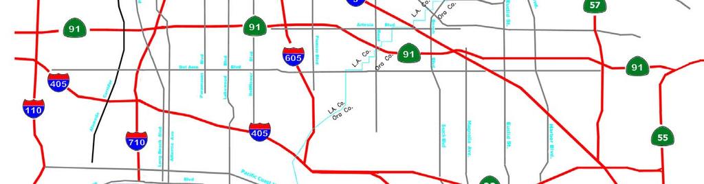
46 46
6.0 CONGESTION HOT SPOT PROBLEM AND IMPROVEMENT TRAVEL DEMAND MODEL ANALYSIS
 6.0 CONGESTION HOT SPOT PROBLEM AND IMPROVEMENT TRAVEL DEMAND MODEL ANALYSIS 6.1 MODEL RUN SUMMARY NOTEBOOK The Model Run Summary Notebook (under separate cover) provides documentation of the multiple
Strategic Transportation Plan FOCUS ON TRANSIT
 Strategic Transportation Plan FOCUS ON TRANSIT Presented to: Gateway Cities Service Council Presented by: Jerry Wood, GCCOG Director of Transportation and Engineering COG2013\2013 - POWER POINTS for JRW
Congestion Management Process (CMP)
") Congestion Management Process (CMP) Introduction The Congestion Management Process (CMP) is a systematic, data-driven, and regionally accepted approach that aims to improve the performance of the transportation
Congestion Management Process (CMP) Introduction The Congestion Management Process (CMP) is a systematic, data-driven, and regionally accepted approach that aims to improve the performance of the transportation
EXHIBIT A. TRANSIT AND MULTIMODAL DEVELOPMENT SUPPORT CONTINUING SERVICES SCOPE OF SERVICES FM No
 EXHIBIT A TRANSIT AND MULTIMODAL DEVELOPMENT SUPPORT CONTINUING SERVICES SCOPE OF SERVICES FM No. 429768-4-12-01 This Exhibit forms an integral part of the Agreement between the DEPARTMENT and, the CONSULTANT,
SR 710 Environmental Study
 SR 710 Environmental Study Alternatives Analysis s Technical Advisory Committee Meeting No. 5 May 9, 2012 1 1 Agenda > Recap of TAC Meeting No. 4 > Recommended alternative concepts for conceptual engineering
Summary of Technical Memoranda 6a, 6b, and 7 for the Stakeholder Advisory Group. July 25, 2007
 1 Summary of Technical Memoranda 6a, 6b, and 7 for the Stakeholder Advisory Group July 25, 2007 2 Presentation Overview 1. Review of the Multi-County Goods Movement Action Plan (MCGMAP) study area and
The Caltrans Contract Manager will assign specific projects to the Consultant through the issuance of Task Orders.
 Scope of Work/Deliverables Environmental Services for Project Specific High Desert Corridor Area of Los Angeles and San Bernardino Counties (District 7 & 8) Attachment 1 Page 1 of 11 A. Project Description
Truck Management ` Strategies in Los Angeles
 Truck Management ` Strategies in Los Angeles Susan Bok, AICP Senior Transportation Planner Los Angeles Department of Transportation NACTO Chicago Workshop May 11-12, 2009 Context Population Downtown LA
TRANSPORTATION IMPACT ANALYSISGUIDELINES
 TRANSPORTATION IMPACT ANALYSISGUIDELINES ADOPTED OCTOBER2014 SANTACLARAVALLEYTRANSPORTATION AUTHORITY CONGESTION MANAGEMENTPROGRAM CONGESTION MANAGEMENT PROGRAM TRANSPORTATION IMPACT ANALYSIS GUIDELINES
THE PROJECT. Executive Summary. City of Industry. City of Diamond Bar. 57/60 Confluence.
 THE PROJECT A freeway segment ranked 6th worst in the Nation, with levels of congestion, pollution and accidents that are simply unacceptable and which have Statewide and National implications. Executive
I-710 Project Committee Meeting
 Los Angeles County Metropolitan Transportation Authority I-710 Project Committee Meeting January 29, 2009 Meeting Expectations Review I-710 planning context Concur on a port cargo forecast scenario to
Comprehensive Regional Goods Movement Plan and Implementation Strategy Study Introduction and Overview
 Comprehensive Regional Goods Movement Plan and Implementation Strategy Study Introduction and Overview presented to Regional Goods Movement Steering Committee SCAG s Consulting Team: Cambridge Systematics,
Database and Travel Demand Model
 Database and Travel Demand Model 7 The CMP legislation requires every CMA, in consultation with the regional transportation planning agency (the Metropolitan Transportation Commission (MTC) in the Bay
12 Evaluation of Alternatives
 12 Evaluation of Alternatives This chapter evaluates the effectiveness of the No-Build Alternative and the proposed METRO Blue Line Light Rail Transit (BLRT) Extension project based on the information
INDIANA S INTERMODAL MANAGEMENT SYSTEM Stephen C. Smith Planning Manager, Transportation Planning Division Indiana Department of Transportation
 96 INDIANA S INTERMODAL MANAGEMENT SYSTEM Stephen C. Smith Planning Manager, Transportation Planning Division Indiana Department of Transportation Indiana is in the process of developing an Intermodal
Los Angeles County Congestion Reduction Demonstration Project
 Los Angeles County Congestion Reduction Demonstration Project frequently asked questions update #1 /august 2008 Los Angeles County Metropolitan Transportation Authority (Metro), California Department of
TECHNICAL MEMORANDUM I-710 EIR/EIS INITIAL FEASIBILITY ANALYSIS (IFA) TECHNICAL APPENDIX WBS TASK ID:
 TECHNICAL APPENDIX WBS TASK ID:") FINAL REPORT TECHNICAL MEMORANDUM I-710 EIR/EIS INITIAL FEASIBILITY ANALYSIS (IFA) TECHNICAL APPENDIX WBS TASK ID: 165.10.09 Prepared for Los Angeles County Metropolitan Transportation Authority December
FINAL REPORT TECHNICAL MEMORANDUM I-710 EIR/EIS INITIAL FEASIBILITY ANALYSIS (IFA) TECHNICAL APPENDIX WBS TASK ID: 165.10.09 Prepared for Los Angeles County Metropolitan Transportation Authority December
Northern Intermodal Transit Facility WHAT IS AN INTERMODAL TRANSIT FACILITY?
 WHAT IS AN INTERMODAL TRANSIT FACILITY? An intermodal transit facility gathers many modes of transportation together and is strategically located to increase destination alternatives. Intermodal facilities
Presentation to the Streets and Freeways Subcommittee
 Presentation to the Streets and Freeways Subcommittee Michael Cano, Deputy Executive Officer March 2019 LA County Goods Movement: Updates 2 2018: Highly successful year for Goods Movement in LA County
9. TRAVEL FORECAST MODEL DEVELOPMENT
 9. TRAVEL FORECAST MODEL DEVELOPMENT To examine the existing transportation system and accurately predict impacts of future growth, a travel demand model is necessary. A travel demand model is a computer
Exhibit A Mn/DOT Contract No
 Exhibit A Mn/DOT Contract No. 98142 SCOPE OF WORK AND DELIVERABLES Preliminary Design Red Wing US 63 Bridge and Approach Roadways State Project (SP) 2515-21 SCOPE OVERVIEW... 2 SCHEDULE... 2 PROJECT TASK
ATTACHMENT A. Detailed Study Scope. I-66 (Inside) Multi-modal Study Scope
 Multi-modal Study Scope") ATTACHMENT A Detailed Study Scope I-66 (Inside) Multi-modal Study Scope EXECUTIVE SUMMARY The Virginia Department of Transportation (VDOT) seeks consultant assistance in identifying and evaluating a range
ATTACHMENT A Detailed Study Scope I-66 (Inside) Multi-modal Study Scope EXECUTIVE SUMMARY The Virginia Department of Transportation (VDOT) seeks consultant assistance in identifying and evaluating a range
CITY OF SAN MATEO GENERAL PLAN MITIGATION MONITORING AND REPORTING PROGRAM
 CITY OF SAN MATEO GENERAL PLAN MITIGATION MONITORING AND REPORTING PROGRAM INTRODUCTION This document is the (MMRP) for the Mateo General Plan. This MMRP has been prepared pursuant to Section 21081.6 of
EXHIBIT A SCOPE OF SERVICES FOR MODAL DEVELOPMENT (MD) SUPPORT - CONTINUING. Financial Project Nos
 SUPPORT - CONTINUING. Financial Project Nos") EXHIBIT A SCOPE OF SERVICES FOR MODAL DEVELOPMENT (MD) SUPPORT - CONTINUING Financial Project Nos. 411461-1-12-10 422799-2-12-12 FLORIDA DEPARTMENT OF TRANSPORTATION DISTRICT SEVEN Revised: 07/16/18 07/10/18
EXHIBIT A SCOPE OF SERVICES FOR MODAL DEVELOPMENT (MD) SUPPORT - CONTINUING Financial Project Nos. 411461-1-12-10 422799-2-12-12 FLORIDA DEPARTMENT OF TRANSPORTATION DISTRICT SEVEN Revised: 07/16/18 07/10/18
Colorado Statewide Intercity and Regional Bus Network Plan Scope of Work October 5th, 2006
 Colorado Statewide Intercity and Regional Bus Network Plan Scope of Work October 5th, 2006 Study Purpose: The Colorado Department of Transportation (CDOT) is requesting proposals to conduct a study of
FLORIDA DEPARTMENT OF TRANSPORTATION PROCEDURE DEVELOPMENT OF THE
 FLORIDA DEPARTMENT OF TRANSPORTATION PROCEDURE DEVELOPMENT OF THE FLORIDA INTRASTATE HIGHWAY SYSTEM Topic No.: 525-030-250-f Office: Systems Planning Effective Date: May 16, 2002 DEVELOPMENT OF THE FLORIDA
APPENDIX B. Public Works and Development Engineering Services Division Guidelines for Traffic Impact Studies
 APPENDIX B Public Works and Development Engineering Services Division Guidelines for Traffic Impact Studies Revised December 7, 2010 via Resolution # 100991 Reformatted March 18, 2011 TABLE OF CONTENTS
ELEMENT M GROWTH MANAGEMENT
 Growth Management ELEMENT M GROWTH MANAGEMENT GOAL: To ensure that growth and development are integrally planned with, and phased concurrently with, the City of Irvine s ability to provide an adequate
5.0 PRELIMINARY ENVIRONMENTAL REVIEW
 5.0 PRELIMINARY ENVIRONMENTAL REVIEW 5.1 INTRODUCTION A preliminary environmental review was performed on the proposed freeway improvements that form Concept C, which encompasses the three freeway corridors
ITS NEWS. Building Southern California s Goods Movement System for the Next Century. Gateway Cities. I-710 Zero Emissions Freight Corridor
 Building Southern California s Goods Movement System for the Next Century Gateway Cities ITS NEWS Summer 2013 I-710 Zero Emissions Freight Corridor PAGE 4 FRATIS Demonstration Advances PAGE 10 ALSO IN
Appendix O Congestion Management Program REGIONAL TRANSPORTATION PLAN/SUSTAINABLE COMMUNITIES STRATEGY
 Appendix O Congestion Management Program REGIONAL TRANSPORTATION PLAN/SUSTAINABLE COMMUNITIES STRATEGY 2014 REGIONAL CONGESTION MANAGEMENT PROGRAM 2014 RTP/SCS APPENDIX O SAN JOAQUIN COUNCIL OF GOVERNMENTS
Environmental Impact Statement for the Green Line to the Airport Project. ACTION: Notice of Intent to Prepare an Environmental Impact Statement (EIS).
.") This document is scheduled to be published in the Federal Register on 11/18/2015 and available online at http://federalregister.gov/a/2015-29418, and on FDsys.gov DEPARTMENT OF TRANSPORTATION Federal Transit
This document is scheduled to be published in the Federal Register on 11/18/2015 and available online at http://federalregister.gov/a/2015-29418, and on FDsys.gov DEPARTMENT OF TRANSPORTATION Federal Transit
Future Build Alternative Traffic Forecasts and Level of Service Analysis
 4.2.10 Future Build Alternative Traffic Forecasts and Level of Service Analysis For the five Build Alternatives, study intersections within one mile of potential station locations were analyzed, as it
Guidelines for the Submission of a Transportation Study Level 2
 Guidelines for the Submission of a Transportation Study Level 2 For Site Development Applications in the City of North Vancouver Transportation Group, City of North Vancouver Engineering, Parks & Environment
Notice of Preparation For Link Union Station (Link US) Project. Joint Environmental Impact Statement and Environmental Impact Report
 Project. Joint Environmental Impact Statement and Environmental Impact Report") Notice of Preparation For Link Union Station (Link US) Project Joint Environmental Impact Statement and Environmental Impact Report Date: May 27, 2016 To: Subject: Project Title: From: All Interested Agencies,
Notice of Preparation For Link Union Station (Link US) Project Joint Environmental Impact Statement and Environmental Impact Report Date: May 27, 2016 To: Subject: Project Title: From: All Interested Agencies,
Proposed Comprehensive Update to the State of Rhode Island s Congestion Management Process
 Proposed Comprehensive Update to the State of Rhode Island s Statewide Planning Program January 2018 Summary Outline of of Action Steps 1. Develop Objectives for Congestion Management What is the desired
Summary of transportation-related goals and objectives from existing regional plans
 SMTC 2050 Long Range Transportation Plan Appendix A: Summary of transportation-related goals and objectives from existing regional plans SMTC 2050 Long Range Transportation Plan Summary of transportation-related
Transportation Advisory Board May 21, 2014
 Transportation Advisory Board May 21, 2014 1 2040 TPP Schedule April 2013 to May 2014: Policymaker Task Force, Partner Agency Work Group and other stakeholder discussions on preparation of draft 2040 TPP
Regional Transit Framework Study
 MARICOPA ASSOCIATION OF GOVERNMENTS Regional Transit Framework Study Regional Stakeholders Group Meeting #1 February 29, 2008 Copyright 2008 AGENDA Welcome and Introductions Project Process Regional Transit
Regional Performance Measures Annual Progress Report TPO Board - 2/4/2016 Presentation by: Chris Wichman, Senior Planner
 2015 TPO Board - 2/4/2016 Presentation by: Chris Wichman, Senior Planner Overview History and definition of performance-based planning & programming Review of 2015 TPO Board Action Requested 2 History
INTELLIGENT TRANSPORTATION SYSTEMS APPENDIX
 INTELLIGENT TRANSPORTATION SYSTEMS APPENDIX Southern California Association of Governments ADOPTED APRIL 2012 INTELLIGENT TRANSPORTATION SYSTEMS Introduction 1 Existing System Description 1 Existing System
Office of Freight, Logistics, and Passenger Operations Transit and Intermodal Support Scope of Services
 Purpose The Department requires the assistance of a Consultant for a range of professional engineering, planning, policy, in-house support staff and other technical services to support the Transit Office
Strategic Transportation Plan. Presented to: ECO-Rapid Transit Board of Directors Presented by: Gill V. Hicks, Cambridge Systematics, Inc.
 Strategic Transportation Plan Presented to: ECO-Rapid Transit Board of Directors Presented by: Gill V. Hicks, Cambridge Systematics, Inc. June 11, 2014 1 Local Solutions for all Gateway Cities Communities
West Santa Ana Branch Transit Corridor. Draft EIS/EIR Scoping Interagency Meeting June 19, 2017
 West Santa Ana Branch Transit Corridor Draft EIS/EIR Scoping Interagency Meeting June 19, 2017 Agenda > Welcome and Introductions > Purpose of Interagency Scoping > Timeline and Process > Agency Coordination
Northwest State Route 138 Corridor Improvement Project
 Northwest State Route 138 Corridor Improvement Project Los Angeles County, CA DISTRICT 7- LA- 138 (PM 0.0/36.8); DISTRICT 7- LA- 05 (PM 79.5/83.1); DISTRICT 7- LA- 14 (PM 73.4/74.4) 265100/ 0700001816
NEW ORLEANS REGION TRANSIT COMPREHENSIVE OPERATIONS ANALYSIS SCOPE OF SERVICES. RPC Project LA90X361
 NEW ORLEANS REGION TRANSIT COMPREHENSIVE OPERATIONS ANALYSIS SCOPE OF SERVICES RPC Project LA90X361 Overview Summary The purpose of the Comprehensive Operations Analysis (COA) is to provide detailed review
- FACT SHEET - THE GUIDING PRINCIPLES
 THE GUIDING PRINCIPLES The General Plan begins with seven ideas that together create a vision for the City s future. When the City approved the General Plan in 1994, these idea were dubbed the Seven Guiding
FEDERAL HIGHWAY ADMINISTRATION RECORD OF DECISION FOR THE LYNNWOOD LINK EXTENSION
 FEDERAL HIGHWAY ADMINISTRATION RECORD OF DECISION FOR THE LYNNWOOD LINK EXTENSION AUGUST 2015 Table of Contents 1 Decision... 1 1.1 Project Description... 2 1.2 Basis for the FHWA Decision... 7 1.2.1
SCS Scenario Planning
 E SCS Scenario Planning Introduction As part of the 2035 MTP/SCS process, AMBAG developed a series of land use and transportation alternative scenarios for evaluation and testing to demonstrate how the
Final Congestion Management Process
 Final Congestion Management Process 2015 Prepared by Tulare County Association of Governments 210 N. Church St., Suite B Visalia, California 93291 1. Introduction: What Is Congestion? Congestion can generally
State Route 710 North Environmental Study Update Online Media Briefing July 12, 2013
 State Route 710 North Environmental Study Update Online Media Briefing July 12, 2013 Frank Quon, P.E. Executive Officer, Metro Highway Program Michelle Smith, P.E. Project Manager, Metro Highway Program
City of Menifee. Public Works Department. Traffic Impact Analysis Guidelines
 Public Works Department Traffic Impact Analysis Guidelines Revised: August 2015 TABLE OF CONTENTS INTRODUCTION... 3 PURPOSE... 3 EXEMPTIONS... 3 SCOPING... 4 METHODOLOGY... 5 STUDY AREA... 6 STUDY SCENARIOS...
Evaluation of Alternatives
 Chapter 9.0 Evaluation of Alternatives Chapter 9.0 provides a summary evaluation of the No Build Alternative and the Preferred Alternative. The evaluation contained within this chapter is an assessment
Request for Proposals. Hillsdale Pedestrian/Bicyclist Bridge Design
 Request for Proposals Hillsdale Pedestrian/Bicyclist Bridge Design Public Works Department City of San Mateo 330 West 20th Avenue San Mateo, CA 94403 JUNE 13, 2013 The City of San Mateo (CITY) is accepting
City of Berkeley. Guidelines for Development of Traffic Impact Reports
 Office of Transportation (OOT) City of Berkeley Guidelines for Development of Traffic Impact Reports Office of Transportation, City of Berkeley 1 1. Overview These guidelines provide a framework to help
TRANSPORTATION IMPACT ANALYSIS GUIDELINES
 TRANSPORTATION IMPACT ANALYSIS GUIDELINES SANTA CLARA COUNTY TRANSPORTATION AUTHORITY CONGESTION MANAGEMENT PROGRAM ADOPTED MARCH 2009 TABLE OF CONTENTS PART I - STATUTE AND AUTHORITY...1 CHAPTER 1. CMP
Final Land Use and Development Opportunities Report 5.0 Environmental Impact/Environmental Consequences
 Figure 5-6. Century City 1/4-Mile Station Area August 16, 2010 Page 5-14 Figure 5-7. Wilshire/Westwood 1/4-Mile Station Area August 16, 2010 Page 5-15 Alternative 1 would be constructed underneath existing
Chapter 5 Transportation Draft
 Chapter 5 Transportation Draft Discussion Similar to the other elements in the Comprehensive Plan, the transportation element impacts the quality of life, economic development and public safety of the
Purpose and Organization PROGRAM ENVIRONMENTAL IMPACT REPORT. Native American Consultation Workshop
 PROGRAM ENVIRONMENTAL IMPACT REPORT Native American Consultation Workshop A Presentation by the Southern California Association of Governments October, 2015 Purpose and Organization Introduction Draft
Dated: January 2015 TRANSPORTATION IMPACT STUDY GUIDELINES
 Dated: January 2015 TRANSPORTATION IMPACT STUDY GUIDELINES TABLE OF CONTENTS 1.0 Introduction.. 2 1.1 Transportation Impact Study...... 2 1.2 Need and Justification... 2 1.3 Purpose of Guidelines... 2
Goods Movement Challenges. Opportunities. Solutions. Hasan Ikhrata Director of Planning & Policy Southern California Association of Governments
 Goods Movement Challenges. Opportunities. Solutions Hasan Ikhrata Director of Planning & Policy Southern California Association of Governments The Regional Planning Agency for Southern California 15 th
Scope of Work. Project Approach and Understanding. Task 1: Study Initiation and Administration
 Scope of Work Route 116/Hinesburg Growth Center Corridor Study Town of Hinesburg and CCRPC Project Approach and Understanding Route 116 through Hinesburg had seen substantial changes in the past 15 years,
Intent to Prepare an Environmental Impact Statement for the South Bay Metro
 DEPARTMENT OF TRANSPORTATION Federal Transit Administration Intent to Prepare an Environmental Impact Statement for the South Bay Metro Green Line Extension Transit Corridor, Southwestern Portion of Los
I-710 Corridor Project EIR/EIS Community Outreach Component Statement of Work RFP No. PS ISSUED:
 Los Angeles County Metropolitan Transportation Authority I-710 Corridor Project EIR/EIS Community Outreach Component Statement of Work RFP No. PS4340-1940 ISSUED: 11.20.06 RFP No. PS43401940 1 SOW FACILITATION
TRANSPORTATION RELATIONSHIP TO OTHER ELEMENTS OF THE PLAN AND COUNTY REGULATIONS VISION FOR TRANSPORTATION PLANNING ROAD NETWORK SECTION 7
 TRANSPORTATION Like many growing western counties, Douglas County focuses on one of the most integral elements in land-use planning: transportation. The primary purpose of a transportation network is to
CROWS LANDING CORRIDOR PLAN
 ATTACHMENT 1: SCOPE OF WORK CROWS LANDING CORRIDOR PLAN INTRODUCTION: StanCOG proposes the Crows Landing Corridor Plan (Plan), which is needed to determine the feasibility of inter-jurisdictional transportation
BOSTON REGION METROPOLITAN PLANNING ORGANIZATION MEMORANDUM
 BOSTON REGION METROPOLITAN PLANNING ORGANIZATION State Transportation Building Ten Park Plaza, Suite 2150 Boston, MA 02116-3968 Tel. (617) 973-7100 Fax (617) 973-8855 TTY (617) 973-7089 www.bostonmpo.org
GUIDE FOR THE PREPARATION OF TRAFFIC IMPACT STUDIES
 GUIDE FOR THE PREPARATION OF TRAFFIC IMPACT STUDIES Adopted by Town Council on November 25, 2008 Prepared By: HNTB Engineering Department Planning Department TABLE OF CONTENTS I. INTRODUCTION... 1 II.
ACTIVE TRANSPORTATION ADVISORY COMMITTEE. Memphis MPO March 30, 2015
 ACTIVE TRANSPORTATION ADVISORY COMMITTEE Memphis MPO March 30, 2015 Agenda Welcome & Introductions Announcements and Briefings Livability 2040: Regional Transportation Plan Congestion Management Process
Corpus Christi Metropolitan Transportation Plan Fiscal Year Introduction:
 Introduction: Traffic congestion in the Corpus Christi Metropolitan area is not as much a function of population growth as the function of the increase in single occupant trips. Using census data, the
Chapter 3 - Goals, Objectives, & Strategies
 Chapter 3 - This chapter presents goals, objectives, and strategies that have been developed as part of the Richmond Area MPO 2026 Long-Range Transportation Plan (LRTP) update. Strategies have been developed
Technical Memorandum 3 Executive Summary Existing Conditions and Constraints Presentation. March 22, 2006
 Technical Memorandum 3 Executive Summary Existing Conditions and Constraints Presentation March 22, 2006 MCGMAP Overview Develop a: Goods Movement Action Plan M A X I M I Z E S Mitigation of communities'
Chapter 2 Transportation Element Goals, Objectives and Policies
 Chapter 2 Transportation Element Goals, Objectives and Policies City of Belleview Comprehensive Plan Adopted by Ord 2016-10 on July 5, 2016 GOALS, OBJECTIVES AND POLICIES Goal 2 Transportation...1 Objective
SOUTHWEST LRT (METRO GREEN LINE EXTENSION)
") 8 Evaluation of Alternatives This chapter evaluates the effectiveness of the No Build Alternative and the Southwest Light Rail Transit (LRT) Project (the Project) based on the information contained in
8 Evaluation of Alternatives This chapter evaluates the effectiveness of the No Build Alternative and the Southwest Light Rail Transit (LRT) Project (the Project) based on the information contained in
PennDOT Office of Planning
 Every Voice Counts PennDOT Office of Planning Environmental Justice Plan Executive Summary Developed for: Pennsylvania Department of Transportation Office of Planning Center for Program Development and
vi Figures viii Summary S.1
 Contents Contents iii Tables vi Figures viii Summary S.1 Chapter 1: Purpose and Need Project History A.1 Project Description A.2 Project Purpose A.5 Transportation Need A.6 Highway Capacity and Congestion
The Policies section will also provide guidance and short range policies in order to accomplish the goals and objectives.
 4 Goals & Objectives INTRODUCTION The 2015-2040 MTP preserves and promotes the quality of life and economic prosperity of the MAB by providing a transportation system consistent with the regional goals.
KAW CONNECTS EXECUTIVE SUMMARY
 Executive Summary Page E-1 Introduction KAW CONNECTS EXECUTIVE SUMMARY The Kansas Department of Transportation (KDOT) and the Kansas Turnpike Authority (KTA) have both recognized the need to plan for the
GDOT-Office of Planning Update
 GDOT-Office of Planning Update GAMPO Conference Athens, Georgia Matthew Fowler, PTP Assistant Planning Administrator November 30, 2010 AGENDA Atlanta Region Managed Lane System Plan I-85 HOV to HOT Conversion
CHAPTER 3.0 CIRCULATION ELEMENT
 CHAPTER 3.0 CIRCULATION ELEMENT The Circulation Element identifies the general location and extent of existing and proposed major transportation facilities for vehicle, rail, air, water, and bicycle transportation
Richard Clarke Executive Director Program Management. Capital Program Management
 Richard Clarke Executive Director Program Management Capital Program Management Department Overview > Transit, Highway Programs, and Regional Rail o Transit Deliver construction projects on-time and within
Contents i Contents Page 1 A New Transportation Plan Community Involvement Goals and Objectives... 11
 Contents i Contents 1 A New Transportation Plan... 1 Why develop a new plan?... 1 What area does the LRTP focus on?... 2 Why is this LRTP important?... 3 Meeting Requirements for Transportation Planning...
I-710 Corridor Project EIR/EIS Engineering/Environmental Component Statement of Work RFP No. PS ISSUED:
 Los Angeles County Metropolitan Transportation Authority I-710 Corridor Project EIR/EIS Engineering/Environmental Component Statement of Work RFP No. PS43401939 ISSUED: 11.17.06 Name: Interstate 710 Corridor
TIER 2 EIS SCOPING MEETING WELCOME TO THE FEDERAL AVIATION ADMINISTRATION SCOPING MEETING
 TIER 2 EIS SCOPING MEETING WELCOME TO THE FEDERAL AVIATION ADMINISTRATION SCOPING MEETING TIER 2 EIS OVERVIEW SOUTH SUBURBAN INAUGURAL AIRPORT ENVIRONMENTAL IMPACT STATEMENT The proposed, (SSA) will require
INDEX EXHIBIT A SCOPE OF SERVICES FINANCIAL PROJECT NUMBER
 INDEX EXHIBIT A SCOPE OF SERVICES FINANCIAL PROJECT NUMBER 442930-1-32-01 I-4 Beyond the Ultimate (BTU) CORRIDOR MANAGEMENT CONTINUING SERVICES CONTRACT PAGE NO. I. PURPOSE...1 II. GENERAL...1 A. Beginning
CHAPTER 2. VISION, GOALS AND MTP FRAMEWORK
 CHAPTER 2. VISION, GOALS AND MTP FRAMEWORK MTP VISION In order to create a framework for the 2040 Metropolitan Transportation Plan (MTP), a vision statement was drafted by the Vision/Goals Committee and
South Bay Metro Green Line Extension
 Meeting Agenda Project overview and update Recap of the Scoping Meetings Progress on the project alternative and proposed station locations Meeting Schedule 6:00 Open House 6:30 Presentation 7:15 Public
Section 2.0 Introduction and Purpose
 Section 2.0 SECTION 2.0 INTRODUCTION AND PURPOSE The California Environmental Quality Act (CEQA) requires that all State and local agencies consider the environmental consequences of projects over which
2016 RTP/SCS Performance Measures Update Technical Working Group
 2016 RTP/SCS Performance Measures Update Technical Working Group March 19, 2015 Ping Chang & Naresh Amatya SCAG Staff Presentation Outline Background Evolving/Enhanced Performance Measures (PM) Framework
Summary. Preliminary Alternative Development and Screening. DEIS July 23, 2018
 What is the Carolina Crossroads Project? The South Carolina Department of Transportation (SCDOT), in cooperation with the Federal Highway Administration (FHWA), is proposing to upgrade and redesign a key
EXECUTIVE SUMMARY REGIONAL TRANSPORTATION PLAN 2050
 EXECUTIVE SUMMARY REGIONAL TRANSPORTATION PLAN 2050 Introduction Goals Policies, and Performance Measures Growth Forecast and Planned Land Use Development Key Recommendations i Executive Summary April
Interstate 73 FEIS: I-95 to the Myrtle Beach Region Chapter 4. Public Involvement and Agency Coordination
 4-65 Interstate 73 FEIS: I-95 to the Myrtle Beach Region 4-66 Comment noted. The use of existing roadways was considered during alternative development (refer to Chapter 2, Section 2.1, page 2-1 and the
Transportation Committee
 Transportation Committee For the Metropolitan Council meeting of April 9, 2008 ADVISORY INFORMATION Date Prepared: March 27, 2008 Subject: Lowry Avenue Intermodal Freight Connector Committee Report Item:
LARKSPUR SMART STATION AREA PLAN. Public Workshop December 3, 2013
 LARKSPUR SMART STATION AREA PLAN Public Workshop December 3, 2013 0 PURPOSE OF Provide information about the regional planning context for the Larkspur Station Area, including Plan Bay Area, SMART, and
Transit Service Guidelines
 G R E AT E R VA N CO U V E R T R A N S P O RTAT I O N A U T H O R I T Y Transit Service Guidelines PUBLIC SUMMARY REPORT JUNE 2004 Greater Vancouver Transportation Authority TRANSIT SERVICE GUIDELINES
The Level of Service Metric and. Alternatives for Multi-Modal Transportation. in Oakland
 The Level of Service Metric and Alternatives for Multi-Modal Transportation in Oakland By Jill Nevins For the City of Oakland, Public Works Agency Mills College Public Policy Program May 2012 Executive
Comprehensive Transportation Study for Glencoe, MN
 Comprehensive Transportation Study for Glencoe, MN Introduction and Project Information Introduction There have been a number of planning and preliminary engineering studies completed in the Glencoe area
Vicinity Map. Interstate 605 (I-605) and State Route 91 (SR-91) in Los Angeles County
 and State Route 91 (SR-91) in Los Angeles County") 07 - LA - 605 - PM 2.87/PM 6.36 07 - LA - 91 - PM 14.10/PM 19.81 Vicinity Map N On Routes Interstate 605 (I-605) and State Route 91 (SR-91) in Los Angeles County I-605 between Excelsior Dr UC (PM 6.36)
07 - LA - 605 - PM 2.87/PM 6.36 07 - LA - 91 - PM 14.10/PM 19.81 Vicinity Map N On Routes Interstate 605 (I-605) and State Route 91 (SR-91) in Los Angeles County I-605 between Excelsior Dr UC (PM 6.36)
CALIFORNIA STATEWIDE RURAL INTERCITY BUS STUDY. California Department of Transportation Division of Mass Transportation.
 Page 1 of 12 Caltrans CALIFORNIA STATEWIDE RURAL INTERCITY BUS STUDY California Department of Transportation Division of Mass Transportation October 2005, (DMT) September 20 7:12 PM 1 Page 2 of 12 Caltrans