MINTO COMMUNITIES INC GREENBANK ROAD NOISE CONTROL FEASIBILITY STUDY
|
|
|
- Allen Moody
- 5 years ago
- Views:
Transcription
1 MINTO COMMUNITIES INC GREENBANK ROAD NOISE CONTROL FEASIBILITY STUDY June 2017 Prepared for: MINTO COMMUNITIES INC. 180 Kent Street, Suite 200 Ottawa, Ontario K1P 0B6 Prepared by: J.L. RICHARDS & ASSOCIATES LIMITED 864 Lady Ellen Place Ottawa, ON K1Z 5M2 Tel: Fax: JLR No.:
2 MINTO COMMUNITIES INC GREENBANK ROAD NOISE CONTROL FEASIBILITY STUDY Table of Contents 1.0 INTRODUCTION PROJECT DESCRIPTION TRANSPORTATION NOISE SOURCE Transportation Sound Level Criteria Transportation Noise Attenuation Requirements Prediction of Noise Levels (Transportation) Road Traffic Data Noise Level Calculations (Transportation) Summary of Findings (Transportation) Summary of Findings (Building Component) CONCLUSION AND RECOMMENDATIONS... 9 List of Tables TABLE 1 - Outdoor Noise Control Measures for Surface Transportation Noise... 2 TABLE 2 - Indoor Noise Control Measures for Surface Transportation Noise... 3 TABLE 3 - Outdoor Living Area (OLA) Noise Limit for Surface Transportation... 3 TABLE 4 - Indoor Noise Limit for Surface Transportation... 3 TABLE 5 - Road Traffic Data to Predict Noise Levels... 4 TABLE 6 - Predicted Freefield Noise Levels and Distances from Individual Noise Sources.. 5 TABLE 7 - Potential Noise Attenuation Due to Barriers... 7 TABLE 8 Predicted Freefield Noise Levels and Distances from Realigned Greenbank... 7 TABLE 9 - Minimum Window and Wall Construction Types... 8 TABLE 10 - AIF Value Conversion to STC Value... 9 List of Figures FIGURE 1 Location Plan List of Appendices Appendix A Appendix B Appendix C Draft Plan of Subdivision Freefield Daytime Noise Contours N1 Potential Noise Barriers N2 Freefield Daytime Noise Contours (Realigned Greenbank) N3 City of Ottawa Surface Transportation Sample Warning Clauses Transportation Noise Source Predictions - Detailed Predicted Freefield Noise Level Calculations (Individual Noise Sources) J.L. Richards & Associates Limited June 2017 JLR No.: i-
3 MINTO COMMUNITIES INC GREENBANK ROAD NOISE CONTROL FEASIBILITY STUDY Appendix D Appendix E Appendix F Appendix G Appendix H Appendix I Transportation Noise Source Predictions - Detailed Predicted Freefield Noise Level Calculations (Combined Road Noise Sources) Transportation Noise Source Predictions - Detailed Predicted Mitigated Noise Level Calculations (Combined Road Noise Sources) Transportation Noise Source Predictions - Detailed Predicted Freefield Noise Level Calculations (Realigned Greenbank Road) Building Elevation Drawings - The Venice-2015 Building Component Calculations - Room Calculations - Table 9: Building Component Template (Venice) Canada Mortgage and Housing (CMHC) Table A2 and A3 - Approximate Conversion from STC to AIF for Windows and Doors - Approximate Conversion from STC to AIF for Exterior Walls and Ceiling-Roof Systems J.L. Richards & Associates Limited June 2017 JLR No.: ii-
4 MINTO COMMUNITIES INC GREENBANK ROAD NOISE CONTROL FEASIBILITY STUDY 1.0 INTRODUCTION Minto Communities Inc. (Minto) has retained the services of J.L. Richards & Associates Limited (JLR) to prepare a Noise Control Feasibility Study for their development located at 3311 Greenbank Road, situated in Barrhaven, within the City of Ottawa. The purpose of this study is to assess the potential environmental noise impact on the Development, due to vehicular traffic on existing Greenbank Road, Jockvale Road, Longfields Drive and Street No. 1. This Noise Control Feasibility Study develops a strategy for subdivision development that minimizes the reliance upon noise barriers, ventilation requirements and air conditioning as a means of addressing roadway noise and instead examines land use, roadway layout and building orientation as a principal means to mitigate roadway noise. Land use and building orientation identified in this study will then be examined in detail as part of the Noise Control Detailed Design Study prepared for the subdivision application. This report is prepared to satisfy the City of Ottawa Environmental Noise Control Guidelines (approved by City Council January 2016) and in particular Part 4 Section 3.1 Noise Control Feasibility Study Requirements. 2.0 PROJECT DESCRIPTION Minto s Development is located within the City of Ottawa s Official Plan (OP) boundary, and consists of a +/-4.7 ha parcel bounded by an existing High School to the north, Greenbank Road to the west, Jockvale Road and Longfields Drive to the east, and vacant residential land to the south, as depicted on the Location Plan in Figure TRANSPORTATION NOISE SOURCE The transportation noise sources include existing Greenbank Road, Jockvale Road, Longfields Drive, and Street No. 1. Drawing N1 shows the location of the existing and proposed roadways in relation to the proposed development. It should be noted that Greenbank Road is proposed to be realigned, however, at the time this feasibility study was prepared the alignment of Greenbank Road was still conceptual as shown on Drawing N Transportation Sound Level Criteria For the purpose of determining the predicted noise levels, and based on the sound level criteria established by the City of Ottawa Environmental Noise Control Guidelines (ENCG), the following will be used as the maximum acceptable sound levels (Leq) for residential development and other land uses, such as nursing homes, schools and daycare centres: J.L. Richards & Associates Limited June 2017 JLR No.:
5
6 MINTO COMMUNITIES INC GREENBANK ROAD NOISE CONTROL FEASIBILITY STUDY Receiver Location Criteria Time Period Outdoor living area: 55 dba Daytime ( hrs) Indoor living/dining rooms (inside): 45 dba Daytime ( hrs) General Office, Reception Area (inside): 50 dba Daytime ( hrs) Sleeping Quarters (inside): 40 dba Nighttime ( hrs) Outdoor Living Areas (OLA) are defined as that portion of the outdoor amenity area of a dwelling for the quiet enjoyment of the outdoor environment during the daytime period. Typically, the point of assessment in an OLA is 3.0 m from the building façade mid-point and 1.5 m above the ground within the designated OLA for each individual unit. OLAs commonly include backyards, balconies (with a minimum depth of 4 m as per NPC-300), common outdoor living areas, and passive recreational areas. 3.2 Transportation Noise Attenuation Requirements When the sound levels are equal to or less than the specified criteria, per the City of Ottawa ENCG and/or MOE NPC-300, no noise attenuation (control) measures are required. The following tables outline noise attenuation measures to achieve required dba Leq for surface transportation noise, per the City of Ottawa ENCG. Table 1: Outdoor Noise Control Measures for Surface Transportation Noise Primary Mitigation Measure (in order of preference) Distance setback with soft ground Insertion of Noise insensitive land uses between the source and receiver receptor Orientation of buildings to provide sheltered zones in rear yards Shared outdoor amenity areas Earth berms (sound barriers) Acoustic Barriers (acoustic barriers) Secondary Mitigation Measures Landscape plantings and/or non-acoustic fence to obscure noise source Recommended Required Warning Clauses Warning Clauses necessary and to include: - Reference to specific noise mitigation measures in the development. - Whether noise is expected to increase in the future. - That there is a need to maintain mitigation. J.L. Richards & Associates Limited June 2017 JLR No.:
7 MINTO COMMUNITIES INC GREENBANK ROAD NOISE CONTROL FEASIBILITY STUDY Table 2: Indoor Noise Control Measures for Surface Transportation Noise Primary Mitigation Measure (in order of preference) Distance setback with soft ground Insertion of Noise insensitive land uses between the source and receiver receptor Orientation of buildings to provide sheltered zones or modified interior spaces and amenity areas Enhanced construction techniques and construction quality Earth berms (sound barriers) Indoor isolation air conditioning and ventilation, enhanced dampening materials (indoor isolation) Secondary Mitigation Measures Landscape plantings and/or non-acoustic fence to obscure noise source Recommended Required Warning Clauses Not necessary Warning Clauses necessary and to include: - Reference to specific noise mitigation measures in the development. - Whether noise is expected to increase in the future. - That there is a need to maintain mitigation. The following tables outline the noise level limits per the MOE NPC-300 and City of Ottawa ENCG. Table 3: Outdoor Living Area (OLA) Noise Limit for Surface Transportation Time Period Leq (16 hr) (dba) 16 hr, 07:00 am - 23:00 55 Table 4: Indoor Noise Limit for Surface Transportation Type of Space Living/Dining, den areas of residences, hospitals, nursing homes, schools, daycare centres, etc. Living/Dining, den areas of residences, hospitals, nursing homes, etc. (except schools or daycare centres) Sleeping Quarters Time Period Leq (dba) Road Rail 07:00-23: :00-07: :00-23: :00-07: In addition to the implementation of noise attenuation features, if required, and depending on the severity of the noise problem, warning clauses may be recommended to advise the prospective purchasers/tenants of affected units of the potential environmental noise. These warning clauses should be included in the Site Plan and Subdivision Agreements, in the Offers J.L. Richards & Associates Limited June 2017 JLR No.:
8 MINTO COMMUNITIES INC GREENBANK ROAD NOISE CONTROL FEASIBILITY STUDY of Purchase and Sale, and should be registered on Title. Warning clauses may be included for any development, irrespective of whether it is considered a noise sensitive land use. Where site measures are required to mitigate noise levels, the City of Ottawa requires that notices be placed on Title informing potential buyers and/or tenants of the site conditions. Sample templates of the notices that could be registered on Title are included in Appendix C as presented in the City of Ottawa ENCG. Detailed wording for clauses should be provided as part of a detailed Noise Impact Study to be completed in support of the Subdivision Application. Clauses are to be worded to describe the mitigation measures and noise conditions applicable where MOECC and City of Ottawa noise criteria are exceeded. 3.3 Prediction of Noise Levels (Transportation) Road Traffic Data The following traffic data was used to predict noise levels: Table 5: Road Traffic Data to Predict Noise Levels Jockvale Road/Longfields Drive Existing Greenbank Road Jockvale Road Street No. 1 Total Traffic Volume (AADT) 35,000 15,000 8,000 8,000 Day/Night Split (%) 92/8 92/8 92/8 92/8 Medium Trucks (%) Heavy Trucks (%) Posted Speed (km/hr) Road Gradient (%) Road Classification 4-Lane Urban Arterial Divided (4-UAD) 2-Lane Urban Arterial (2-UAU) 2-Lane Urban Collector (2-UCU) 2-Lane Urban Collector (2-UCU) Schedule E and Annex 1 of the City of Ottawa Official Plan (May 2003) were utilized to determine the correct road classification and protected right-of-way. These road classifications were compared to Map 6 of the City of Ottawa Transportation Master Plan (Road Network Urban). All findings were then compared to Table B1 (Part 4, Appendix B ) of the City of Ottawa Environmental Noise Control Guidelines in order to determine an appropriate AADT value. J.L. Richards & Associates Limited June 2017 JLR No.:
9 MINTO COMMUNITIES INC GREENBANK ROAD NOISE CONTROL FEASIBILITY STUDY Noise Level Calculations (Transportation) Noise contours for the daytime periods were developed using the MOE Road Traffic Noise Computer program STAMSON, Version The following procedure was used to establish the contours: 1. Distances were calculated from the centre of the roadway to even 5 dba freefield noise levels ranging from 50 dba to 70 dba for each of the roadways. Table 6 below presents this information. Computer printouts are included in Appendix C. Drawing N1 identifies the receiver locations as contours for the calculations of the roadway freefield noise levels. 2. Additional calculations were conducted to generate freefield noise levels where two roadways intersect to establish the distances along a 45 degree angle from the centre of the intersection. For example, receiver locations were identified along the bisecting angle between existing Greenbank Road and Street No. 1. These receiver locations are identified on Drawing N1. 3. These calculations were then compiled to prepare freefield noise level contours for each of existing Greenbank Road, Jockvale/Longfields Drive, Jockvale Drive and Street No. 1. Drawing N1 presents these contours. For the purpose of this study, only the daytime freefield noise levels are presented. Computer printouts are included in Appendix D for each of the receivers presented on Drawing N1. Table 6: Predicted Freefield Noise Levels and Distances from Individual Noise Sources Roads 4-UAD (Jockvale/Longfields Drive) 60km/hr Contour (dba) OLA (Freefield) Distance (m) Daytime UAU (Greenbank Road) 60km/hr n/a J.L. Richards & Associates Limited June 2017 JLR No.:
10 MINTO COMMUNITIES INC GREENBANK ROAD NOISE CONTROL FEASIBILITY STUDY Roads 2-UCU (Jockvale Drive) 60km/hr Contour (dba) OLA (Freefield) Distance (m) Daytime n/a UCU (Street No. 1) 50km/hr n/a 70 n/a 3.4 Summary of Findings (Transportation) The development of 3311 Greenbank Road will result in multiple blocks of residential units that will be impacted by roadway traffic noise. Blocks 1, 2, 9, and 10 will support townhome blocks that will front onto Street No. 1 and/or flank onto existing Greenbank Road or Jockvale Road. Freefield noise levels at the property line will be between approximately 65 dba as presented on Figure N1. A noise barrier is projected to be required to mitigate outdoor living area noise levels. As a minimum, a 2.5 m high noise barrier will be required along the rear lot line between the school property and Blocks 1, 2, 9, and 10. Noise levels will be lowered to approximately 55 dba at the outdoor living area. The location of the receiver and noise barrier are presented on Figure N2. It is recommended that details concerning the height of the noise barrier and mitigated noise levels and landscape treatment be confirmed in the Noise Impact Study prepared for the subdivision development. Warning Clauses similar to those presented in Appendix B will be required to highlight the exceedance of MOECC and City of Ottawa noise criteria and to identify mitigation measures integrated into the subdivision design. Warning clauses could be required for Blocks 1-11, 17, 18, 23, 24, 29, 30, and surrounding blocks until it can be demonstrated that the noise guideline criteria is not exceeded. It is recommended that specific wording be developed for each unit and/or Block in the Noise Impact Study prepared to support the subdivision application. The following Table 7 summarizes the predicted freefield daytime noise levels at selected locations and the potential mitigated noise levels resulting from the inclusion of the noise attenuation barriers, as shown on Drawing N2. J.L. Richards & Associates Limited June 2017 JLR No.:
11 MINTO COMMUNITIES INC GREENBANK ROAD NOISE CONTROL FEASIBILITY STUDY Computer printouts are included in Appendix E. Table 7: Potential Noise Attenuation Due to Barriers Receiver Location Daytime Noise Level (dba) Freefield Attenuation Leq 16 (dba) Height of Barrier (m) R1 Block 1, R2 Blocks 9, For the purposes of this report, the future realigned Greenbank Road is conservatively considered a 4-Lane Urban Divided Arterial with an AADT of 35,000 and a speed limit of 80 km/hr. Using the conceptual alignment from the Greenbank Road Class Environmental Assessment Amendment 2013 (as shown on Drawing N3) the impact on 3311 Greenbank Road is predicted to be less than the impact of the existing Greenbank Road. The following Table 8 summarizes the predicted freefield daytime noise levels for the realigned Greenbank Road, as shown on Drawing N3 with contours. Table 8: Predicted Freefield Noise Levels and Distances from Realigned Greenbank Roads Contour (dba) OLA (Freefield) Distance (m) Daytime 4-UAD (Realigned Greenbank Road) 80km/hr Computer printouts are included in Appendix F. 3.5 Summary of Findings (Building Component) JLR completed a preliminary analysis of a Minto Executive townhome to determine if sufficient acoustical insulation is provided with a typical building construction to mitigate interior noise levels to MOECC and City of Ottawa criteria. The Acoustical Insulation Factor (AIF) Method, as described in the Ministry of the Environment Ontario, Ontario Publication, Environmental Noise Assessment in Land Use Planning (ENALUP) 1987 (Page 10-29) was used, to assess the building construction required to mitigate exterior noise to meet interior noise criteria. For the J.L. Richards & Associates Limited June 2017 JLR No.:
12 MINTO COMMUNITIES INC GREENBANK ROAD NOISE CONTROL FEASIBILITY STUDY purpose of this assessment, an exterior freefield noise level of 65 dba at the plane of window was conservatively utilized to determine wall and window construction. This noise level was utilized even for walls and windows where the noise levels would be mitigated by the noise barrier. Minto provided floor plan and building elevation drawings for the Venice unit. This unit is considered representative of the type to be constructed on either of Blocks 1, 2, 9, 10 and other surrounding Blocks. Floor and elevation drawings are included in Appendix G. Using Minto s drawings JLR calculated the window areas, floor areas and wall areas for the each of the rooms within each of the units. This data was then used to calculate either the window to floor area ratios or the wall to floor area ratios. Design tables provided in the ENALUP were then utilized to identify either minimum window construction or wall construction requirements to mitigate the exterior noise levels. Table 9 in Appendix H presents the working calculations for the window and wall requirements necessary to acoustically insulate each of the principal rooms within each of the representative units. The following table presents a summary of the analysis with the minimum standard window and wall construction required per unit type. Table 9: Minimum Window and Wall Construction Types Unit Type Executive Townhome (i.e., Venice) Window Type Glass Thickness (Spacing) Glass Thickness (Spacing) Glass Thickness 3(6)3(6)3 Triple Pane Exterior Wall Type EW1 For this analysis, the sliding glass door identified on the plans is treated as a window. The acoustic insulation factor methodology does not account for sliding glass doors as a door type. It is noted that no additional doors are identified with a connection to the principal interior rooms such as the living room, bedroom or kitchen area. A standard wall construction detail with 38 x 89 mm complete with siding, sheathing, insulation and 12.7 mm gypsum board will provide satisfactory acoustic insulation to achieve indoor noise requirements. Exterior wall type construction notes: EW1 Standard wall construction (noted above), with sheathing, wood or metal siding and fibre backer board. Minto s standard exterior wall construction is 38 x 148 mm complete with 140 mm fibre insulation, siding, 19 mm sheathing, 12.7 mm gypsum board, and occasionally brick veneer on the exterior lower level wall. It should be noted that other types of window and wall construction could be chosen to achieve the same minimum noise mitigation. These details will be established during the detailed building component study in consultation with Minto. J.L. Richards & Associates Limited June 2017 JLR No.:
13 MINTO COMMUNITIES INC GREENBANK ROAD NOISE CONTROL FEASIBILITY STUDY Tables A2 and A3 from Canada Mortgage and Housing s (CMHC) publication, Airport Noise, revised 1981 were used to convert AIF values to the more widely recognized Sound Transmission Class (STC) values. Appendix I presents these CMHC tables. AIF and equivalent STC values are presented on Table 10 for the town unit bedroom with the highest AIF requirement. It is recommended that at the time of building permit application that the AIF/STC be confirmed to suit the specific unit proposed for the Block. Table 10: AIF Value Conversion to STC Value Type of Unit AIF Required Windows Walls Window/Floor Area Ratio AIF Conversion Formula STC Wall/Floor Area Ratio AIF Conversion Formula STC Town Unit 32 20% STC % STC CONCLUSION AND RECOMMENDATIONS Predicted noise levels are expected to exceed the City of Ottawa ENCG and MOE criteria for the proposed units adjacent to existing Greenbank Road and Jockvale Road. To address these exceedances, Minto has revised the subdivision plan to reduce the reliance of noise barriers as the primary noise mitigation tool. Building orientation and increased separation to the transportation noise source have been used to reduce noise levels for residential units in close proximity to a significant transportation noise source. Noise barriers will still be required to protect outdoor living areas. However, the resulting noise levels are expected to be approximate to the criteria established by the City for each of the proposed residential Blocks proposed. Preliminary calculations indicate that 2.5 m high noise barriers will satisfactorily mitigate noise levels for the outdoor living areas for each of the residential blocks. It is recommended that the City of Ottawa accept the draft plan subdivision submitted and include a condition for the proponent to complete a Noise Impact Study as per the City of Ottawa ENCG 2016 for the 3311 Greenbank Road development. It is further recommended that the following be addressed as part of a detailed Noise Impact Study: Noise barrier details, such as height and location are to be identified for each of Blocks 1, 2, 9 and 10. Noise levels should be assessed at the building façade of units nearest the transportation noise sources. If it is determined that the noise level at the façade of a building exceeds dba, then the Acoustical Insulation Factor (AIF) method be utilized to review building acoustic measures to be incorporated into the building construction. This method is described in J.L. Richards & Associates Limited June 2017 JLR No.:
14
15 MINTO COMMUNITIES INC GREENBANK ROAD NOISE CONTROL FEASIBILITY STUDY Appendix A Draft Plan of Subdivision Freefield Daytime Noise Contours N1 Potential Noise Barriers N2 Freefield Daytime Noise Contours (Realigned Greenbank) N3
 DON HERWEYER, MCIP RPP MANAGER, DEVELOPMENT REVIEW-SOUTH PLANNING, INFRASTRUCTURE AND ECONOMIC DEVELOPMENT DEPARTMENT, CITY OF OTTAWA DRAFT PLAN OF SUBDIVISION of PART OF LOTS")
16 SUBJECT TO THE CONDITIONS, IF ANY, SET FORTH IN OUR LETTER DATED 20 THIS DRAFT PLAN IS APPROVED BY THE CITY OF OTTAWA UNDER SECTION 51 OF THE PLANNING ACT. THIS DAY OF,2017. KEY PLAN (NOT TO SCALE) DON HERWEYER, MCIP RPP MANAGER, DEVELOPMENT REVIEW-SOUTH PLANNING, INFRASTRUCTURE AND ECONOMIC DEVELOPMENT DEPARTMENT, CITY OF OTTAWA DRAFT PLAN OF SUBDIVISION of PART OF LOTS 12 AND 13 CONCESSION 2 (RIDEAU FRONT) (GEOGRAPHIC TOWNSHIP OF NEPEAN) CITY OF OTTAWA Scale 1: METRES S C H E D U L E O F L A N D U S E BLOCK USE UNITS AREA (Ha/ac) 1 TO 32 RESIDENTIAL / MISC. 0.04/ RESERVE 0.004/0.01 STREETS STREET 1.60/3.96 TOTAL /11.79 INFORMATION: REQUIRED UNDER SECTION 51 (17) OF THE PLANNING ACT R.S.O a. SEE PLAN b. SEE PLAN c. SEE PLAN d. SEE PROPOSED LAND USE SCHEDULE (ABOVE) e. SEE PLAN f. SEE PLAN g. SEE PLAN h. CITY WATER AVAILABLE i. SEE SOIL REPORT j. SEE TOPOGRAPHICAL INFORMATION k. ALL CITY SERVICES AVAILABLE l. NO EASEMENTS REGISTERED ON TITLE DATED : DATED : SUSAN MURPHY VICE PRESIDENT, DEVELOPMENT BRENT STRACHAN SENIOR VICE PRESIDENT, DEVELOPMENT DATE BRIAN J. WEBSTER ONTARIO LAND SURVEYOR stantec.com DRAWN: CEC CHECKED: * PM: FP FIELD: * PROJECT No.:
17
18
19
20 MINTO COMMUNITIES INC GREENBANK ROAD NOISE CONTROL FEASIBILITY STUDY Appendix B City of Ottawa Surface Transportation Sample Warning Clauses
21 City of Ottawa Environmental Noise Control Guidelines Sample Warning Clauses Generic Purchasers/tenants are advised that sound levels due to increasing road/rail/light Rail/transitway traffic may occasionally interfere with some outdoor activities as the sound levels may exceed the sound level limits of the City and the Ministry of the Environment. To help address the need for sound attenuation this development has been designed so as to provide an outdoor amenity area that is within provincial guidelines. Measures for sound attenuation include: A setback of buildings from the noise source and An acoustic barrier. To ensure that provincial sound level limits are not exceeded it is important to maintain sound attenuation features. The acoustic barrier shall be maintained and kept in good repair by the property owner. Any maintenance, repair or replacement is the responsibility of the owner and shall be with the same material or to the same standards, having the same colour, appearance and function of the original. Additionally this development includes trees and shrubs to screen the source of noise from occupants. Extensive mitigation of indoor and outdoor amenity area Purchasers/tenants are advised that despite the inclusion of noise control features in the development and within the building units, sound levels due to increasing road/rail/light Rail/transitway traffic may, on occasion, interfere with some activities of the dwelling occupants as the sound levels exceed the sound level limits of the City and the Ministry of the Environment. To help address the need for sound attenuation this development includes: multi-pane glass; double brick veneer; an earth berm; and an acoustic barrier. To ensure that provincial sound level limits are not exceeded it is important to maintain these sound attenuation features. The acoustic barrier shall be maintained and kept in good repair by the property owner. Any maintenance, repair or replacement is the responsibility of the owner and shall be with the same material or to the same standards, having the same colour, appearance and function of the original. This dwelling unit has also been designed with the provision for adding central air conditioning at the occupant s discretion. Installation of central air conditioning will allow windows and exterior doors to remain closed, thereby ensuring that the indoor sound levels are within the sound level limits of the City and the Ministry of the Environment. Additionally this development includes trees and shrubs to screen the source of noise from occupants.
22 No Outdoor amenity area Purchasers/tenants are advised that sound levels due to increasing road/rail/light Rail/transitway traffic will interfere with outdoor activities as the sound levels exceed the sound level limits of the City and the Ministry of the Environment. To help address the need for sound attenuation this development includes: multi-pane glass; double brick veneer; high sound transmission class walls. To ensure that provincial sound level limits are not exceeded it is important to maintain these sound attenuation features. This dwelling unit has been supplied with a central air conditioning system and other measures which will allow windows and exterior doors to remain closed, thereby ensuring that the indoor sound levels are within the sound level limits of the City and the Ministry of the Environment
23 MINTO COMMUNITIES INC GREENBANK ROAD NOISE CONTROL FEASIBILITY STUDY Appendix C Transportation Noise Source Predictions - Detailed Predicted Freefield Noise Level Calculations (Individual Noise Sources)
24 STAMSON 5.0 NORMAL REPORT Date: :04:37 MINISTRY OF ENVIRONMENT AND ENERGY / NOISE ASSESSMENT Filename: 2uau_50d.te Time Period: Day/Night 16/8 hours Description: 2UAU daytime ff 50 dba Road data, segment # 1: 2-UAU (day/night) Car traffic volume : 12144/1056 veh/timeperiod * Medium truck volume : 966/84 veh/timeperiod * Heavy truck volume : 690/60 veh/timeperiod * Posted speed limit : 60 km/h Road gradient : 1 % Road pavement : 1 (Typical asphalt or concrete) * Refers to calculated road volumes based on the following input: 24 hr Traffic Volume (AADT or SADT): Percentage of Annual Growth : 0.00 Number of Years of Growth : 0.00 Medium Truck % of Total Volume : 7.00 Heavy Truck % of Total Volume : 5.00 Day (16 hrs) % of Total Volume : Data for Segment # 1: 2-UAU (day/night) Angle1 Angle2 : deg deg Wood depth : 0 (No woods.) No of house rows : 0 / 0 Surface : 1 (Absorptive ground surface) Receiver source distance : / m Receiver height : 1.50 / 4.50 m Topography : 1 (Flat/gentle slope; no barrier) Reference angle : 0.00 Results segment # 1: 2-UAU (day) ROAD ( ) = dba Segment Leq : dba Total Leq All Segments: dba
25 Results segment # 1: 2-UAU (night) ROAD ( ) = dba Segment Leq : dba Total Leq All Segments: dba TOTAL Leq FROM ALL SOURCES (DAY): (NIGHT): STAMSON 5.0 NORMAL REPORT Date: :06:04 MINISTRY OF ENVIRONMENT AND ENERGY / NOISE ASSESSMENT Filename: 2uau_55d.te Time Period: Day/Night 16/8 hours Description: 2UAU daytime ff 55 dba Road data, segment # 1: 2-UAU (day/night) Car traffic volume : 12144/1056 veh/timeperiod * Medium truck volume : 966/84 veh/timeperiod * Heavy truck volume : 690/60 veh/timeperiod * Posted speed limit : 60 km/h Road gradient : 1 % Road pavement : 1 (Typical asphalt or concrete) * Refers to calculated road volumes based on the following input: 24 hr Traffic Volume (AADT or SADT): Percentage of Annual Growth : 0.00 Number of Years of Growth : 0.00 Medium Truck % of Total Volume : 7.00 Heavy Truck % of Total Volume : 5.00 Day (16 hrs) % of Total Volume : Data for Segment # 1: 2-UAU (day/night) Angle1 Angle2 : deg deg
26 Wood depth : 0 (No woods.) No of house rows : 0 / 0 Surface : 1 (Absorptive ground surface) Receiver source distance : / m Receiver height : 1.50 / 4.50 m Topography : 1 (Flat/gentle slope; no barrier) Reference angle : 0.00 Results segment # 1: 2-UAU (day) ROAD ( ) = dba Segment Leq : dba Total Leq All Segments: dba Results segment # 1: 2-UAU (night) ROAD ( ) = dba Segment Leq : dba Total Leq All Segments: dba TOTAL Leq FROM ALL SOURCES (DAY): (NIGHT): 55.00
27 STAMSON 5.0 NORMAL REPORT Date: :07:13 MINISTRY OF ENVIRONMENT AND ENERGY / NOISE ASSESSMENT Filename: 2uau_60d.te Time Period: Day/Night 16/8 hours Description: 2UAU daytime ff 60 dba Road data, segment # 1: 2-UAU (day/night) Car traffic volume : 12144/1056 veh/timeperiod * Medium truck volume : 966/84 veh/timeperiod * Heavy truck volume : 690/60 veh/timeperiod * Posted speed limit : 60 km/h Road gradient : 1 % Road pavement : 1 (Typical asphalt or concrete) * Refers to calculated road volumes based on the following input: 24 hr Traffic Volume (AADT or SADT): Percentage of Annual Growth : 0.00 Number of Years of Growth : 0.00 Medium Truck % of Total Volume : 7.00 Heavy Truck % of Total Volume : 5.00 Day (16 hrs) % of Total Volume : Data for Segment # 1: 2-UAU (day/night) Angle1 Angle2 : deg deg Wood depth : 0 (No woods.) No of house rows : 0 / 0 Surface : 1 (Absorptive ground surface) Receiver source distance : / m Receiver height : 1.50 / 4.50 m Topography : 1 (Flat/gentle slope; no barrier) Reference angle : 0.00 Results segment # 1: 2-UAU (day) ROAD ( ) = dba Segment Leq : dba Total Leq All Segments: dba
28 Results segment # 1: 2-UAU (night) ROAD ( ) = dba Segment Leq : dba Total Leq All Segments: dba TOTAL Leq FROM ALL SOURCES (DAY): (NIGHT): STAMSON 5.0 NORMAL REPORT Date: :08:26 MINISTRY OF ENVIRONMENT AND ENERGY / NOISE ASSESSMENT Filename: 2uau_65d.te Time Period: Day/Night 16/8 hours Description: 2UAU daytime ff 65 dba Road data, segment # 1: 2-UAU (day/night) Car traffic volume : 12144/1056 veh/timeperiod * Medium truck volume : 966/84 veh/timeperiod * Heavy truck volume : 690/60 veh/timeperiod * Posted speed limit : 60 km/h Road gradient : 1 % Road pavement : 1 (Typical asphalt or concrete) * Refers to calculated road volumes based on the following input: 24 hr Traffic Volume (AADT or SADT): Percentage of Annual Growth : 0.00 Number of Years of Growth : 0.00 Medium Truck % of Total Volume : 7.00 Heavy Truck % of Total Volume : 5.00 Day (16 hrs) % of Total Volume : Data for Segment # 1: 2-UAU (day/night) Angle1 Angle2 : deg deg
29 Wood depth : 0 (No woods.) No of house rows : 0 / 0 Surface : 1 (Absorptive ground surface) Receiver source distance : / m Receiver height : 1.50 / 4.50 m Topography : 1 (Flat/gentle slope; no barrier) Reference angle : 0.00 Results segment # 1: 2-UAU (day) ROAD ( ) = dba Segment Leq : dba Total Leq All Segments: dba Results segment # 1: 2-UAU (night) ROAD ( ) = dba Segment Leq : dba Total Leq All Segments: dba TOTAL Leq FROM ALL SOURCES (DAY): (NIGHT): 61.10
30 STAMSON 5.0 NORMAL REPORT Date: :53:37 MINISTRY OF ENVIRONMENT AND ENERGY / NOISE ASSESSMENT Filename: 2ucu_50d.te Time Period: Day/Night 16/8 hours Description: Paine & Riverchase daytime ff 50 dba Road data, segment # 1: 2-UCU (day/night) Car traffic volume : 6477/563 veh/timeperiod * Medium truck volume : 515/45 veh/timeperiod * Heavy truck volume : 368/32 veh/timeperiod * Posted speed limit : 50 km/h Road gradient : 1 % Road pavement : 1 (Typical asphalt or concrete) * Refers to calculated road volumes based on the following input: 24 hr Traffic Volume (AADT or SADT): 8000 Percentage of Annual Growth : 0.00 Number of Years of Growth : 0.00 Medium Truck % of Total Volume : 7.00 Heavy Truck % of Total Volume : 5.00 Day (16 hrs) % of Total Volume : Data for Segment # 1: 2-UCU (day/night) Angle1 Angle2 : deg deg Wood depth : 0 (No woods.) No of house rows : 0 / 0 Surface : 1 (Absorptive ground surface) Receiver source distance : / m Receiver height : 1.50 / 4.50 m Topography : 1 (Flat/gentle slope; no barrier) Reference angle : 0.00 Results segment # 1: 2-UCU (day) ROAD ( ) = dba Segment Leq : dba Total Leq All Segments: dba
31 Results segment # 1: 2-UCU (night) ROAD ( ) = dba Segment Leq : dba Total Leq All Segments: dba TOTAL Leq FROM ALL SOURCES (DAY): (NIGHT): STAMSON 5.0 NORMAL REPORT Date: :58:38 MINISTRY OF ENVIRONMENT AND ENERGY / NOISE ASSESSMENT Filename: 2ucu_55d.te Time Period: Day/Night 16/8 hours Description: Paine & Riverchase daytime freefield 55 dba Road data, segment # 1: 2-UCU (day/night) Car traffic volume : 6477/563 veh/timeperiod * Medium truck volume : 515/45 veh/timeperiod * Heavy truck volume : 368/32 veh/timeperiod * Posted speed limit : 50 km/h Road gradient : 1 % Road pavement : 1 (Typical asphalt or concrete) * Refers to calculated road volumes based on the following input: 24 hr Traffic Volume (AADT or SADT): 8000 Percentage of Annual Growth : 0.00 Number of Years of Growth : 0.00 Medium Truck % of Total Volume : 7.00 Heavy Truck % of Total Volume : 5.00 Day (16 hrs) % of Total Volume : Data for Segment # 1: 2-UCU (day/night) Angle1 Angle2 : deg deg
32 Wood depth : 0 (No woods.) No of house rows : 0 / 0 Surface : 1 (Absorptive ground surface) Receiver source distance : / m Receiver height : 1.50 / 4.50 m Topography : 1 (Flat/gentle slope; no barrier) Reference angle : 0.00 Results segment # 1: 2-UCU (day) ROAD ( ) = dba Segment Leq : dba Total Leq All Segments: dba Results segment # 1: 2-UCU (night) ROAD ( ) = dba Segment Leq : dba Total Leq All Segments: dba TOTAL Leq FROM ALL SOURCES (DAY): (NIGHT): 48.07
33 STAMSON 5.0 NORMAL REPORT Date: :57:41 MINISTRY OF ENVIRONMENT AND ENERGY / NOISE ASSESSMENT Filename: 2ucu_60d.te Time Period: Day/Night 16/8 hours Description: Paine & Riverchase daytime freefield 60 dba Road data, segment # 1: 2-UCU (day/night) Car traffic volume : 6477/563 veh/timeperiod * Medium truck volume : 515/45 veh/timeperiod * Heavy truck volume : 368/32 veh/timeperiod * Posted speed limit : 50 km/h Road gradient : 1 % Road pavement : 1 (Typical asphalt or concrete) * Refers to calculated road volumes based on the following input: 24 hr Traffic Volume (AADT or SADT): 8000 Percentage of Annual Growth : 0.00 Number of Years of Growth : 0.00 Medium Truck % of Total Volume : 7.00 Heavy Truck % of Total Volume : 5.00 Day (16 hrs) % of Total Volume : Data for Segment # 1: 2-UCU (day/night) Angle1 Angle2 : deg deg Wood depth : 0 (No woods.) No of house rows : 0 / 0 Surface : 1 (Absorptive ground surface) Receiver source distance : / m Receiver height : 1.50 / 4.50 m Topography : 1 (Flat/gentle slope; no barrier) Reference angle : 0.00 Results segment # 1: 2-UCU (day) ROAD ( ) = dba Segment Leq : dba Total Leq All Segments: dba
34 Results segment # 1: 2-UCU (night) ROAD ( ) = dba Segment Leq : dba Total Leq All Segments: dba TOTAL Leq FROM ALL SOURCES (DAY): (NIGHT): STAMSON 5.0 NORMAL REPORT Date: :46:14 MINISTRY OF ENVIRONMENT AND ENERGY / NOISE ASSESSMENT Filename: 2ucu_50d.te Time Period: Day/Night 16/8 hours Description: 2UCU daytime ff 50 dba Road data, segment # 1: 2-UCU (day/night) Car traffic volume : 6477/563 veh/timeperiod * Medium truck volume : 515/45 veh/timeperiod * Heavy truck volume : 368/32 veh/timeperiod * Posted speed limit : 60 km/h Road gradient : 1 % Road pavement : 1 (Typical asphalt or concrete) * Refers to calculated road volumes based on the following input: 24 hr Traffic Volume (AADT or SADT): 8000 Percentage of Annual Growth : 0.00 Number of Years of Growth : 0.00 Medium Truck % of Total Volume : 7.00 Heavy Truck % of Total Volume : 5.00 Day (16 hrs) % of Total Volume : Data for Segment # 1: 2-UCU (day/night) Angle1 Angle2 : deg deg
35 Wood depth : 0 (No woods.) No of house rows : 0 / 0 Surface : 1 (Absorptive ground surface) Receiver source distance : / m Receiver height : 1.50 / 4.50 m Topography : 1 (Flat/gentle slope; no barrier) Reference angle : 0.00 Results segment # 1: 2-UCU (day) ROAD ( ) = dba Segment Leq : dba Total Leq All Segments: dba Results segment # 1: 2-UCU (night) ROAD ( ) = dba Segment Leq : dba Total Leq All Segments: Dba TOTAL Leq FROM ALL SOURCES (DAY): (NIGHT): 50.00
36 STAMSON 5.0 NORMAL REPORT Date: :47:24 MINISTRY OF ENVIRONMENT AND ENERGY / NOISE ASSESSMENT Filename: 2ucu_55d.te Time Period: Day/Night 16/8 hours Description: 2UCU daytime ff 55 dba Road data, segment # 1: 2-UCU (day/night) Car traffic volume : 6477/563 veh/timeperiod * Medium truck volume : 515/45 veh/timeperiod * Heavy truck volume : 368/32 veh/timeperiod * Posted speed limit : 60 km/h Road gradient : 1 % Road pavement : 1 (Typical asphalt or concrete) * Refers to calculated road volumes based on the following input: 24 hr Traffic Volume (AADT or SADT): 8000 Percentage of Annual Growth : 0.00 Number of Years of Growth : 0.00 Medium Truck % of Total Volume : 7.00 Heavy Truck % of Total Volume : 5.00 Day (16 hrs) % of Total Volume : Data for Segment # 1: 2-UCU (day/night) Angle1 Angle2 : deg deg Wood depth : 0 (No woods.) No of house rows : 0 / 0 Surface : 1 (Absorptive ground surface) Receiver source distance : / m Receiver height : 1.50 / 4.50 m Topography : 1 (Flat/gentle slope; no barrier) Reference angle : 0.00 Results segment # 1: 2-UCU (day) ROAD ( ) = dba Segment Leq : dba Total Leq All Segments: dba
37 Results segment # 1: 2-UCU (night) ROAD ( ) = dba Segment Leq : dba Total Leq All Segments: dba TOTAL Leq FROM ALL SOURCES (DAY): (NIGHT): STAMSON 5.0 NORMAL REPORT Date: :53:05 MINISTRY OF ENVIRONMENT AND ENERGY / NOISE ASSESSMENT Filename: 2ucu_60d.te Time Period: Day/Night 16/8 hours Description: 2UCU daytime ff 60 dba Road data, segment # 1: 2-UCU (day/night) Car traffic volume : 6477/563 veh/timeperiod * Medium truck volume : 515/45 veh/timeperiod * Heavy truck volume : 368/32 veh/timeperiod * Posted speed limit : 60 km/h Road gradient : 1 % Road pavement : 1 (Typical asphalt or concrete) * Refers to calculated road volumes based on the following input: 24 hr Traffic Volume (AADT or SADT): 8000 Percentage of Annual Growth : 0.00 Number of Years of Growth : 0.00 Medium Truck % of Total Volume : 7.00 Heavy Truck % of Total Volume : 5.00 Day (16 hrs) % of Total Volume : Data for Segment # 1: 2-UCU (day/night) Angle1 Angle2 : deg deg
38 Wood depth : 0 (No woods.) No of house rows : 0 / 0 Surface : 1 (Absorptive ground surface) Receiver source distance : / m Receiver height : 1.50 / 4.50 m Topography : 1 (Flat/gentle slope; no barrier) Reference angle : 0.00 Results segment # 1: 2-UCU (day) ROAD ( ) = dba Segment Leq : dba Total Leq All Segments: dba Results segment # 1: 2-UCU (night) ROAD ( ) = dba Segment Leq : dba Total Leq All Segments: dba TOTAL Leq FROM ALL SOURCES (DAY): (NIGHT): 55.00
39 STAMSON 5.0 NORMAL REPORT Date: :54:17 MINISTRY OF ENVIRONMENT AND ENERGY / NOISE ASSESSMENT Filename: 2ucu_65d.te Time Period: Day/Night 16/8 hours Description: 2UCU daytime ff 65 dba Road data, segment # 1: 2-UCU (day/night) Car traffic volume : 6477/563 veh/timeperiod * Medium truck volume : 515/45 veh/timeperiod * Heavy truck volume : 368/32 veh/timeperiod * Posted speed limit : 60 km/h Road gradient : 1 % Road pavement : 1 (Typical asphalt or concrete) * Refers to calculated road volumes based on the following input: 24 hr Traffic Volume (AADT or SADT): 8000 Percentage of Annual Growth : 0.00 Number of Years of Growth : 0.00 Medium Truck % of Total Volume : 7.00 Heavy Truck % of Total Volume : 5.00 Day (16 hrs) % of Total Volume : Data for Segment # 1: 2-UCU (day/night) Angle1 Angle2 : deg deg Wood depth : 0 (No woods.) No of house rows : 0 / 0 Surface : 1 (Absorptive ground surface) Receiver source distance : / m Receiver height : 1.50 / 4.50 m Topography : 1 (Flat/gentle slope; no barrier) Reference angle : 0.00 Results segment # 1: 2-UCU (day) ROAD ( ) = dba Segment Leq : dba Total Leq All Segments: dba
40 Results segment # 1: 2-UCU (night) ROAD ( ) = dba Segment Leq : dba Total Leq All Segments: dba TOTAL Leq FROM ALL SOURCES (DAY): (NIGHT): STAMSON 5.0 NORMAL REPORT Date: :38:22 MINISTRY OF ENVIRONMENT AND ENERGY / NOISE ASSESSMENT Filename: 4uad_50d.te Time Period: Day/Night 16/8 hours Description: 4UAD daytime ff 50 dba Road data, segment # 1: 4-UAD (day/night) Car traffic volume : 28336/2464 veh/timeperiod * Medium truck volume : 2254/196 veh/timeperiod * Heavy truck volume : 1610/140 veh/timeperiod * Posted speed limit : 60 km/h Road gradient : 1 % Road pavement : 1 (Typical asphalt or concrete) * Refers to calculated road volumes based on the following input: 24 hr Traffic Volume (AADT or SADT): Percentage of Annual Growth : 0.00 Number of Years of Growth : 0.00 Medium Truck % of Total Volume : 7.00 Heavy Truck % of Total Volume : 5.00 Day (16 hrs) % of Total Volume : Data for Segment # 1: 4-UAD (day/night) Angle1 Angle2 : deg deg
41 Wood depth : 0 (No woods.) No of house rows : 0 / 0 Surface : 1 (Absorptive ground surface) Receiver source distance : / m Receiver height : 1.50 / 4.50 m Topography : 1 (Flat/gentle slope; no barrier) Reference angle : 0.00 Results segment # 1: 4-UAD (day) ROAD ( ) = dba Segment Leq : dba Total Leq All Segments: dba Results segment # 1: 4-UAD (night) ROAD ( ) = dba Segment Leq : dba Total Leq All Segments: dba TOTAL Leq FROM ALL SOURCES (DAY): (NIGHT): 50.00
42 STAMSON 5.0 NORMAL REPORT Date: :39:46 MINISTRY OF ENVIRONMENT AND ENERGY / NOISE ASSESSMENT Filename: 4uad_55d.te Time Period: Day/Night 16/8 hours Description: 4UAD daytime ff 55 dba Road data, segment # 1: 4-UAD (day/night) Car traffic volume : 28336/2464 veh/timeperiod * Medium truck volume : 2254/196 veh/timeperiod * Heavy truck volume : 1610/140 veh/timeperiod * Posted speed limit : 60 km/h Road gradient : 1 % Road pavement : 1 (Typical asphalt or concrete) * Refers to calculated road volumes based on the following input: 24 hr Traffic Volume (AADT or SADT): Percentage of Annual Growth : 0.00 Number of Years of Growth : 0.00 Medium Truck % of Total Volume : 7.00 Heavy Truck % of Total Volume : 5.00 Day (16 hrs) % of Total Volume : Data for Segment # 1: 4-UAD (day/night) Angle1 Angle2 : deg deg Wood depth : 0 (No woods.) No of house rows : 0 / 0 Surface : 1 (Absorptive ground surface) Receiver source distance : / m Receiver height : 1.50 / 4.50 m Topography : 1 (Flat/gentle slope; no barrier) Reference angle : 0.00 Results segment # 1: 4-UAD (day) ROAD ( ) = dba Segment Leq : dba Total Leq All Segments: dba
43 Results segment # 1: 4-UAD (night) ROAD ( ) = dba Segment Leq : dba Total Leq All Segments: dba TOTAL Leq FROM ALL SOURCES (DAY): (NIGHT): STAMSON 5.0 NORMAL REPORT Date: :40:53 MINISTRY OF ENVIRONMENT AND ENERGY / NOISE ASSESSMENT Filename: 4uad_60d.te Time Period: Day/Night 16/8 hours Description: 4UAD daytime ff 60 dba Road data, segment # 1: 4-UAD (day/night) Car traffic volume : 28336/2464 veh/timeperiod * Medium truck volume : 2254/196 veh/timeperiod * Heavy truck volume : 1610/140 veh/timeperiod * Posted speed limit : 60 km/h Road gradient : 1 % Road pavement : 1 (Typical asphalt or concrete) * Refers to calculated road volumes based on the following input: 24 hr Traffic Volume (AADT or SADT): Percentage of Annual Growth : 0.00 Number of Years of Growth : 0.00 Medium Truck % of Total Volume : 7.00 Heavy Truck % of Total Volume : 5.00 Day (16 hrs) % of Total Volume : Data for Segment # 1: 4-UAD (day/night) Angle1 Angle2 : deg deg
44 Wood depth : 0 (No woods.) No of house rows : 0 / 0 Surface : 1 (Absorptive ground surface) Receiver source distance : / m Receiver height : 1.50 / 4.50 m Topography : 1 (Flat/gentle slope; no barrier) Reference angle : 0.00 Results segment # 1: 4-UAD (day) ROAD ( ) = dba Segment Leq : dba Total Leq All Segments: dba Results segment # 1: 4-UAD (night) ROAD ( ) = dba Segment Leq : dba Total Leq All Segments: dba TOTAL Leq FROM ALL SOURCES (DAY): (NIGHT): 60.00
45 STAMSON 5.0 NORMAL REPORT Date: :42:23 MINISTRY OF ENVIRONMENT AND ENERGY / NOISE ASSESSMENT Filename: 4uad_65d.te Time Period: Day/Night 16/8 hours Description: 4UAD daytime ff 65 dba Road data, segment # 1: 4-UAD (day/night) Car traffic volume : 28336/2464 veh/timeperiod * Medium truck volume : 2254/196 veh/timeperiod * Heavy truck volume : 1610/140 veh/timeperiod * Posted speed limit : 60 km/h Road gradient : 1 % Road pavement : 1 (Typical asphalt or concrete) * Refers to calculated road volumes based on the following input: 24 hr Traffic Volume (AADT or SADT): Percentage of Annual Growth : 0.00 Number of Years of Growth : 0.00 Medium Truck % of Total Volume : 7.00 Heavy Truck % of Total Volume : 5.00 Day (16 hrs) % of Total Volume : Data for Segment # 1: 4-UAD (day/night) Angle1 Angle2 : deg deg Wood depth : 0 (No woods.) No of house rows : 0 / 0 Surface : 1 (Absorptive ground surface) Receiver source distance : / m Receiver height : 1.50 / 4.50 m Topography : 1 (Flat/gentle slope; no barrier) Reference angle : 0.00 Results segment # 1: 4-UAD (day) ROAD ( ) = dba Segment Leq : dba Total Leq All Segments: dba
46 Results segment # 1: 4-UAD (night) ROAD ( ) = dba Segment Leq : dba Total Leq All Segments: dba TOTAL Leq FROM ALL SOURCES (DAY): (NIGHT): STAMSON 5.0 NORMAL REPORT Date: :43:12 MINISTRY OF ENVIRONMENT AND ENERGY / NOISE ASSESSMENT Filename: 4uad_70d.te Time Period: Day/Night 16/8 hours Description: 4UAD daytime ff 70 dba Road data, segment # 1: 4-UAD (day/night) Car traffic volume : 28336/2464 veh/timeperiod * Medium truck volume : 2254/196 veh/timeperiod * Heavy truck volume : 1610/140 veh/timeperiod * Posted speed limit : 60 km/h Road gradient : 1 % Road pavement : 1 (Typical asphalt or concrete) * Refers to calculated road volumes based on the following input: 24 hr Traffic Volume (AADT or SADT): Percentage of Annual Growth : 0.00 Number of Years of Growth : 0.00 Medium Truck % of Total Volume : 7.00 Heavy Truck % of Total Volume : 5.00 Day (16 hrs) % of Total Volume : Data for Segment # 1: 4-UAD (day/night) Angle1 Angle2 : deg deg
47 Wood depth : 0 (No woods.) No of house rows : 0 / 0 Surface : 1 (Absorptive ground surface) Receiver source distance : / m Receiver height : 1.50 / 4.50 m Topography : 1 (Flat/gentle slope; no barrier) Reference angle : 0.00 Results segment # 1: 4-UAD (day) ROAD ( ) = dba Segment Leq : dba Total Leq All Segments: dba Results segment # 1: 4-UAD (night) ROAD ( ) = dba Segment Leq : dba Total Leq All Segments: dba TOTAL Leq FROM ALL SOURCES (DAY): (NIGHT): 64.78
48 MINTO COMMUNITIES INC GREENBANK ROAD NOISE CONTROL FEASIBILITY STUDY Appendix D Transportation Noise Source Predictions - Detailed Predicted Freefield Noise Level Calculations (Combined Road Noise Sources)
49 STAMSON 5.0 NORMAL REPORT Date: :23:11 MINISTRY OF ENVIRONMENT AND ENERGY / NOISE ASSESSMENT Filename: mit2ucu.te Time Period: Day/Night 16/8 hours Description: 2ucu block 10 r2 mitigated Road data, segment # 1: 2-UCU (day/night) Car traffic volume : 6477/563 veh/timeperiod * Medium truck volume : 515/45 veh/timeperiod * Heavy truck volume : 368/32 veh/timeperiod * Posted speed limit : 60 km/h Road gradient : 1 % Road pavement : 1 (Typical asphalt or concrete) * Refers to calculated road volumes based on the following input: 24 hr Traffic Volume (AADT or SADT): 8000 Percentage of Annual Growth : 0.00 Number of Years of Growth : 0.00 Medium Truck % of Total Volume : 7.00 Heavy Truck % of Total Volume : 5.00 Day (16 hrs) % of Total Volume : Data for Segment # 1: 2-UCU (day/night) Angle1 Angle2 : deg deg Wood depth : 0 (No woods.) No of house rows : 0 / 0 Surface : 1 (Absorptive ground surface) Receiver source distance : / m Receiver height : 1.50 / 4.50 m Topography : 2 (Flat/gentle slope; with barrier) Barrier angle1 : deg Angle2 : deg Barrier height : 2.50 m Barrier receiver distance : 7.00 / 7.00 m Source elevation : 0.00 m Receiver elevation : 0.00 m Barrier elevation : 0.35 m Reference angle : 0.00 Results segment # 1: 2-UCU (day) Barrier height for grazing incidence Source! Receiver! Barrier! Elevation of
50 Height (m)! Height (m)! Height (m)! Barrier Top (m) ! 1.50! 1.15! 1.50 ROAD ( ) = dba Segment Leq : dba Total Leq All Segments: dba Results segment # 1: 2-UCU (night) Barrier height for grazing incidence Source! Receiver! Barrier! Elevation of Height (m)! Height (m)! Height (m)! Barrier Top (m) ! 4.50! 3.15! 3.50 ROAD ( ) = dba * * Bright Zone! Segment Leq : dba Total Leq All Segments: dba TOTAL Leq FROM ALL SOURCES (DAY): (NIGHT): 55.16
51 STAMSON 5.0 NORMAL REPORT Date: :28:38 MINISTRY OF ENVIRONMENT AND ENERGY / NOISE ASSESSMENT Filename: com1_60d.te Time Period: Day/Night 16/8 hours Description: 2uau & 2ucu composite daytime ff 60 dba Road data, segment # 1: 2-UAU (day/night) Car traffic volume : 12144/1056 veh/timeperiod * Medium truck volume : 966/84 veh/timeperiod * Heavy truck volume : 690/60 veh/timeperiod * Posted speed limit : 60 km/h Road gradient : 1 % Road pavement : 1 (Typical asphalt or concrete) * Refers to calculated road volumes based on the following input: 24 hr Traffic Volume (AADT or SADT): Percentage of Annual Growth : 0.00 Number of Years of Growth : 0.00 Medium Truck % of Total Volume : 7.00 Heavy Truck % of Total Volume : 5.00 Day (16 hrs) % of Total Volume : Data for Segment # 1: 2-UAU (day/night) Angle1 Angle2 : deg deg Wood depth : 0 (No woods.) No of house rows : 0 / 0 Surface : 1 (Absorptive ground surface) Receiver source distance : / m Receiver height : 1.50 / 4.50 m Topography : 1 (Flat/gentle slope; no barrier) Reference angle : 0.00 Road data, segment # 2: 2-UCU (day/night) Car traffic volume : 6477/563 veh/timeperiod * Medium truck volume : 515/45 veh/timeperiod * Heavy truck volume : 368/32 veh/timeperiod * Posted speed limit : 50 km/h Road gradient : 1 % Road pavement : 1 (Typical asphalt or concrete) * Refers to calculated road volumes based on the following input: 24 hr Traffic Volume (AADT or SADT): 8000 Percentage of Annual Growth : 0.00 Number of Years of Growth : 0.00
52 Medium Truck % of Total Volume : 7.00 Heavy Truck % of Total Volume : 5.00 Day (16 hrs) % of Total Volume : Data for Segment # 2: 2-UCU (day/night) Angle1 Angle2 : deg deg Wood depth : 0 (No woods.) No of house rows : 0 / 0 Surface : 1 (Absorptive ground surface) Receiver source distance : / m Receiver height : 1.50 / 4.50 m Topography : 1 (Flat/gentle slope; no barrier) Reference angle : 0.00 Results segment # 1: 2-UAU (day) ROAD ( ) = dba Segment Leq : dba Results segment # 2: 2-UCU (day) ROAD ( ) = dba Segment Leq : dba Total Leq All Segments: dba Results segment # 1: 2-UAU (night)
53 ROAD ( ) = dba Segment Leq : dba Results segment # 2: 2-UCU (night) ROAD ( ) = dba Segment Leq : dba Total Leq All Segments: dba TOTAL Leq FROM ALL SOURCES (DAY): (NIGHT): STAMSON 5.0 NORMAL REPORT Date: :38:16 MINISTRY OF ENVIRONMENT AND ENERGY / NOISE ASSESSMENT Filename: com1_65d.te Time Period: Day/Night 16/8 hours Description: 2uau & 2ucu composite daytime ff 65 dba Road data, segment # 1: 2-UAU (day/night) Car traffic volume : 12144/1056 veh/timeperiod * Medium truck volume : 966/84 veh/timeperiod * Heavy truck volume : 690/60 veh/timeperiod * Posted speed limit : 60 km/h Road gradient : 1 % Road pavement : 1 (Typical asphalt or concrete) * Refers to calculated road volumes based on the following input: 24 hr Traffic Volume (AADT or SADT): Percentage of Annual Growth : 0.00 Number of Years of Growth : 0.00
54 Medium Truck % of Total Volume : 7.00 Heavy Truck % of Total Volume : 5.00 Day (16 hrs) % of Total Volume : Data for Segment # 1: 2-UAU (day/night) Angle1 Angle2 : deg deg Wood depth : 0 (No woods.) No of house rows : 0 / 0 Surface : 1 (Absorptive ground surface) Receiver source distance : / m Receiver height : 1.50 / 4.50 m Topography : 1 (Flat/gentle slope; no barrier) Reference angle : 0.00 Road data, segment # 2: 2-UCU (day/night) Car traffic volume : 6477/563 veh/timeperiod * Medium truck volume : 515/45 veh/timeperiod * Heavy truck volume : 368/32 veh/timeperiod * Posted speed limit : 50 km/h Road gradient : 1 % Road pavement : 1 (Typical asphalt or concrete) * Refers to calculated road volumes based on the following input: 24 hr Traffic Volume (AADT or SADT): 8000 Percentage of Annual Growth : 0.00 Number of Years of Growth : 0.00 Medium Truck % of Total Volume : 7.00 Heavy Truck % of Total Volume : 5.00 Day (16 hrs) % of Total Volume : Data for Segment # 2: 2-UCU (day/night) Angle1 Angle2 : deg deg Wood depth : 0 (No woods.) No of house rows : 0 / 0 Surface : 1 (Absorptive ground surface) Receiver source distance : / m Receiver height : 1.50 / 4.50 m Topography : 1 (Flat/gentle slope; no barrier) Reference angle : 0.00 Results segment # 1: 2-UAU (day)
55 ROAD ( ) = dba Segment Leq : dba Results segment # 2: 2-UCU (day) ROAD ( ) = dba Segment Leq : dba Total Leq All Segments: dba Results segment # 1: 2-UAU (night) ROAD ( ) = dba Segment Leq : dba Results segment # 2: 2-UCU (night) ROAD ( ) = dba Segment Leq : dba
56 Total Leq All Segments: dba TOTAL Leq FROM ALL SOURCES (DAY): (NIGHT): STAMSON 5.0 NORMAL REPORT Date: :12:07 MINISTRY OF ENVIRONMENT AND ENERGY / NOISE ASSESSMENT Filename: com1_70d.te Time Period: Day/Night 16/8 hours Description: 4uad and 2ucu composite daytime 70 dba Road data, segment # 1: 4-UAD (day/night) Car traffic volume : 28336/2464 veh/timeperiod * Medium truck volume : 2254/196 veh/timeperiod * Heavy truck volume : 1610/140 veh/timeperiod * Posted speed limit : 60 km/h Road gradient : 1 % Road pavement : 1 (Typical asphalt or concrete) * Refers to calculated road volumes based on the following input: 24 hr Traffic Volume (AADT or SADT): Percentage of Annual Growth : 0.00 Number of Years of Growth : 0.00 Medium Truck % of Total Volume : 7.00 Heavy Truck % of Total Volume : 5.00 Day (16 hrs) % of Total Volume : Data for Segment # 1: 4-UAD (day/night) Angle1 Angle2 : deg deg Wood depth : 0 (No woods.) No of house rows : 0 / 0 Surface : 1 (Absorptive ground surface) Receiver source distance : / m Receiver height : 1.50 / 4.50 m Topography : 1 (Flat/gentle slope; no barrier) Reference angle : 0.00 Road data, segment # 2: 2-UCU (day/night) Car traffic volume : 6477/563 veh/timeperiod * Medium truck volume : 515/45 veh/timeperiod * Heavy truck volume : 368/32 veh/timeperiod *
57 Posted speed limit : 60 km/h Road gradient : 1 % Road pavement : 1 (Typical asphalt or concrete) * Refers to calculated road volumes based on the following input: 24 hr Traffic Volume (AADT or SADT): 8000 Percentage of Annual Growth : 0.00 Number of Years of Growth : 0.00 Medium Truck % of Total Volume : 7.00 Heavy Truck % of Total Volume : 5.00 Day (16 hrs) % of Total Volume : Data for Segment # 2: 2-UCU (day/night) Angle1 Angle2 : deg deg Wood depth : 0 (No woods.) No of house rows : 0 / 0 Surface : 1 (Absorptive ground surface) Receiver source distance : / m Receiver height : 1.50 / 4.50 m Topography : 1 (Flat/gentle slope; no barrier) Reference angle : 0.00 Results segment # 1: 4-UAD (day) ROAD ( ) = dba Segment Leq : dba Results segment # 2: 2-UCU (day) ROAD ( ) = dba Segment Leq : dba
58 Total Leq All Segments: dba Results segment # 1: 4-UAD (night) ROAD ( ) = dba Segment Leq : dba Results segment # 2: 2-UCU (night) ROAD ( ) = dba Segment Leq : dba Total Leq All Segments: dba TOTAL Leq FROM ALL SOURCES (DAY): (NIGHT): STAMSON 5.0 NORMAL REPORT Date: :49:08 MINISTRY OF ENVIRONMENT AND ENERGY / NOISE ASSESSMENT Filename: com2_55d.te Time Period: Day/Night 16/8 hours Description: 2uau & 2ucu composite daytime ff 55 dba Road data, segment # 1: 2-UAU (day/night) Car traffic volume : 12144/1056 veh/timeperiod * Medium truck volume : 966/84 veh/timeperiod * Heavy truck volume : 690/60 veh/timeperiod *
59 Posted speed limit : 60 km/h Road gradient : 1 % Road pavement : 1 (Typical asphalt or concrete) * Refers to calculated road volumes based on the following input: 24 hr Traffic Volume (AADT or SADT): Percentage of Annual Growth : 0.00 Number of Years of Growth : 0.00 Medium Truck % of Total Volume : 7.00 Heavy Truck % of Total Volume : 5.00 Day (16 hrs) % of Total Volume : Data for Segment # 1: 2-UAU (day/night) Angle1 Angle2 : deg deg Wood depth : 0 (No woods.) No of house rows : 0 / 0 Surface : 1 (Absorptive ground surface) Receiver source distance : / m Receiver height : 1.50 / 4.50 m Topography : 1 (Flat/gentle slope; no barrier) Reference angle : 0.00 Road data, segment # 2: 2-UCU (day/night) Car traffic volume : 6477/563 veh/timeperiod * Medium truck volume : 515/45 veh/timeperiod * Heavy truck volume : 368/32 veh/timeperiod * Posted speed limit : 50 km/h Road gradient : 1 % Road pavement : 1 (Typical asphalt or concrete) * Refers to calculated road volumes based on the following input: 24 hr Traffic Volume (AADT or SADT): 8000 Percentage of Annual Growth : 0.00 Number of Years of Growth : 0.00 Medium Truck % of Total Volume : 7.00 Heavy Truck % of Total Volume : 5.00 Day (16 hrs) % of Total Volume : Data for Segment # 2: 2-UCU (day/night) Angle1 Angle2 : deg deg Wood depth : 0 (No woods.) No of house rows : 0 / 0 Surface : 1 (Absorptive ground surface) Receiver source distance : / m Receiver height : 1.50 / 4.50 m
60 Topography : 1 (Flat/gentle slope; no barrier) Reference angle : 0.00 Results segment # 1: 2-UAU (day) ROAD ( ) = dba Segment Leq : dba Results segment # 2: 2-UCU (day) ROAD ( ) = dba Segment Leq : dba Total Leq All Segments: dba Results segment # 1: 2-UAU (night) ROAD ( ) = dba Segment Leq : dba Results segment # 2: 2-UCU (night)
61 ROAD ( ) = dba Segment Leq : dba Total Leq All Segments: dba TOTAL Leq FROM ALL SOURCES (DAY): (NIGHT): STAMSON 5.0 NORMAL REPORT Date: :31:33 MINISTRY OF ENVIRONMENT AND ENERGY / NOISE ASSESSMENT Filename: com2_60d.te Time Period: Day/Night 16/8 hours Description: 2uau & 2ucu composite daytime ff 60 dba Road data, segment # 1: 2-UAU (day/night) Car traffic volume : 12144/1056 veh/timeperiod * Medium truck volume : 966/84 veh/timeperiod * Heavy truck volume : 690/60 veh/timeperiod * Posted speed limit : 60 km/h Road gradient : 1 % Road pavement : 1 (Typical asphalt or concrete) * Refers to calculated road volumes based on the following input: 24 hr Traffic Volume (AADT or SADT): Percentage of Annual Growth : 0.00 Number of Years of Growth : 0.00 Medium Truck % of Total Volume : 7.00 Heavy Truck % of Total Volume : 5.00 Day (16 hrs) % of Total Volume : Data for Segment # 1: 2-UAU (day/night) Angle1 Angle2 : deg deg Wood depth : 0 (No woods.) No of house rows : 0 / 0 Surface : 1 (Absorptive ground surface) Receiver source distance : / m Receiver height : 1.50 / 4.50 m
62 Topography : 1 (Flat/gentle slope; no barrier) Reference angle : 0.00 Road data, segment # 2: 2-UCU (day/night) Car traffic volume : 6477/563 veh/timeperiod * Medium truck volume : 515/45 veh/timeperiod * Heavy truck volume : 368/32 veh/timeperiod * Posted speed limit : 50 km/h Road gradient : 1 % Road pavement : 1 (Typical asphalt or concrete) * Refers to calculated road volumes based on the following input: 24 hr Traffic Volume (AADT or SADT): 8000 Percentage of Annual Growth : 0.00 Number of Years of Growth : 0.00 Medium Truck % of Total Volume : 7.00 Heavy Truck % of Total Volume : 5.00 Day (16 hrs) % of Total Volume : Data for Segment # 2: 2-UCU (day/night) Angle1 Angle2 : deg deg Wood depth : 0 (No woods.) No of house rows : 0 / 0 Surface : 1 (Absorptive ground surface) Receiver source distance : / m Receiver height : 1.50 / 4.50 m Topography : 1 (Flat/gentle slope; no barrier) Reference angle : 0.00 Results segment # 1: 2-UAU (day) ROAD ( ) = dba Segment Leq : dba Results segment # 2: 2-UCU (day)
63 ROAD ( ) = dba Segment Leq : dba Total Leq All Segments: dba Results segment # 1: 2-UAU (night) ROAD ( ) = dba Segment Leq : dba Results segment # 2: 2-UCU (night) ROAD ( ) = dba Segment Leq : dba Total Leq All Segments: dba TOTAL Leq FROM ALL SOURCES (DAY): (NIGHT): 52.86
64 STAMSON 5.0 NORMAL REPORT Date: :40:55 MINISTRY OF ENVIRONMENT AND ENERGY / NOISE ASSESSMENT Filename: com2_65d.te Time Period: Day/Night 16/8 hours Description: 2uau & 2ucu composite daytime ff 65 dba Road data, segment # 1: 2-UAU (day/night) Car traffic volume : 12144/1056 veh/timeperiod * Medium truck volume : 966/84 veh/timeperiod * Heavy truck volume : 690/60 veh/timeperiod * Posted speed limit : 60 km/h Road gradient : 1 % Road pavement : 1 (Typical asphalt or concrete) * Refers to calculated road volumes based on the following input: 24 hr Traffic Volume (AADT or SADT): Percentage of Annual Growth : 0.00 Number of Years of Growth : 0.00 Medium Truck % of Total Volume : 7.00 Heavy Truck % of Total Volume : 5.00 Day (16 hrs) % of Total Volume : Data for Segment # 1: 2-UAU (day/night) Angle1 Angle2 : deg deg Wood depth : 0 (No woods.) No of house rows : 0 / 0 Surface : 1 (Absorptive ground surface) Receiver source distance : / m Receiver height : 1.50 / 4.50 m Topography : 1 (Flat/gentle slope; no barrier) Reference angle : 0.00 Road data, segment # 2: 2-UCU (day/night) Car traffic volume : 6477/563 veh/timeperiod * Medium truck volume : 515/45 veh/timeperiod * Heavy truck volume : 368/32 veh/timeperiod * Posted speed limit : 50 km/h Road gradient : 1 % Road pavement : 1 (Typical asphalt or concrete) * Refers to calculated road volumes based on the following input: 24 hr Traffic Volume (AADT or SADT): 8000 Percentage of Annual Growth : 0.00 Number of Years of Growth : 0.00
65 Medium Truck % of Total Volume : 7.00 Heavy Truck % of Total Volume : 5.00 Day (16 hrs) % of Total Volume : Data for Segment # 2: 2-UCU (day/night) Angle1 Angle2 : deg deg Wood depth : 0 (No woods.) No of house rows : 0 / 0 Surface : 1 (Absorptive ground surface) Receiver source distance : / m Receiver height : 1.50 / 4.50 m Topography : 1 (Flat/gentle slope; no barrier) Reference angle : 0.00 Results segment # 1: 2-UAU (day) ROAD ( ) = dba Segment Leq : dba Results segment # 2: 2-UCU (day) ROAD ( ) = dba Segment Leq : dba Total Leq All Segments: dba Results segment # 1: 2-UAU (night)
66 ROAD ( ) = dba Segment Leq : dba Results segment # 2: 2-UCU (night) ROAD ( ) = dba Segment Leq : dba Total Leq All Segments: dba TOTAL Leq FROM ALL SOURCES (DAY): (NIGHT): STAMSON 5.0 NORMAL REPORT Date: :18:26 MINISTRY OF ENVIRONMENT AND ENERGY / NOISE ASSESSMENT Filename: com2_70d.te Time Period: Day/Night 16/8 hours Description: 4uad and 2ucu composite daytime 70 dba Road data, segment # 1: 4-UAD (day/night) Car traffic volume : 28336/2464 veh/timeperiod * Medium truck volume : 2254/196 veh/timeperiod * Heavy truck volume : 1610/140 veh/timeperiod * Posted speed limit : 60 km/h Road gradient : 1 % Road pavement : 1 (Typical asphalt or concrete) * Refers to calculated road volumes based on the following input: 24 hr Traffic Volume (AADT or SADT): Percentage of Annual Growth : 0.00 Number of Years of Growth : 0.00
67 Medium Truck % of Total Volume : 7.00 Heavy Truck % of Total Volume : 5.00 Day (16 hrs) % of Total Volume : Data for Segment # 1: 4-UAD (day/night) Angle1 Angle2 : deg deg Wood depth : 0 (No woods.) No of house rows : 0 / 0 Surface : 1 (Absorptive ground surface) Receiver source distance : / m Receiver height : 1.50 / 4.50 m Topography : 1 (Flat/gentle slope; no barrier) Reference angle : 0.00 Road data, segment # 2: 2-UCU (day/night) Car traffic volume : 6477/563 veh/timeperiod * Medium truck volume : 515/45 veh/timeperiod * Heavy truck volume : 368/32 veh/timeperiod * Posted speed limit : 60 km/h Road gradient : 1 % Road pavement : 1 (Typical asphalt or concrete) * Refers to calculated road volumes based on the following input: 24 hr Traffic Volume (AADT or SADT): 8000 Percentage of Annual Growth : 0.00 Number of Years of Growth : 0.00 Medium Truck % of Total Volume : 7.00 Heavy Truck % of Total Volume : 5.00 Day (16 hrs) % of Total Volume : Data for Segment # 2: 2-UCU (day/night) Angle1 Angle2 : deg deg Wood depth : 0 (No woods.) No of house rows : 0 / 0 Surface : 1 (Absorptive ground surface) Receiver source distance : / m Receiver height : 1.50 / 4.50 m Topography : 1 (Flat/gentle slope; no barrier) Reference angle : 0.00 Results segment # 1: 4-UAD (day)
68 ROAD ( ) = dba Segment Leq : dba Results segment # 2: 2-UCU (day) ROAD ( ) = dba Segment Leq : dba Total Leq All Segments: dba Results segment # 1: 4-UAD (night) ROAD ( ) = dba Segment Leq : dba Results segment # 2: 2-UCU (night) ROAD ( ) = dba Segment Leq : dba
69 Total Leq All Segments: dba TOTAL Leq FROM ALL SOURCES (DAY): (NIGHT): STAMSON 5.0 NORMAL REPORT Date: :02:08 MINISTRY OF ENVIRONMENT AND ENERGY / NOISE ASSESSMENT Filename: com3_55d.te Time Period: Day/Night 16/8 hours Description: 2ucu & 2ucu composite daytime ff 55 dba Road data, segment # 1: 2-UCU (day/night) Car traffic volume : 6477/563 veh/timeperiod * Medium truck volume : 515/45 veh/timeperiod * Heavy truck volume : 368/32 veh/timeperiod * Posted speed limit : 60 km/h Road gradient : 1 % Road pavement : 1 (Typical asphalt or concrete) * Refers to calculated road volumes based on the following input: 24 hr Traffic Volume (AADT or SADT): 8000 Percentage of Annual Growth : 0.00 Number of Years of Growth : 0.00 Medium Truck % of Total Volume : 7.00 Heavy Truck % of Total Volume : 5.00 Day (16 hrs) % of Total Volume : Data for Segment # 1: 2-UCU (day/night) Angle1 Angle2 : deg deg Wood depth : 0 (No woods.) No of house rows : 0 / 0 Surface : 1 (Absorptive ground surface) Receiver source distance : / m Receiver height : 1.50 / 4.50 m Topography : 1 (Flat/gentle slope; no barrier) Reference angle : 0.00 Road data, segment # 2: 2-UCU (day/night) Car traffic volume : 6477/563 veh/timeperiod * Medium truck volume : 515/45 veh/timeperiod * Heavy truck volume : 368/32 veh/timeperiod *
70 Posted speed limit : 50 km/h Road gradient : 1 % Road pavement : 1 (Typical asphalt or concrete) * Refers to calculated road volumes based on the following input: 24 hr Traffic Volume (AADT or SADT): 8000 Percentage of Annual Growth : 0.00 Number of Years of Growth : 0.00 Medium Truck % of Total Volume : 7.00 Heavy Truck % of Total Volume : 5.00 Day (16 hrs) % of Total Volume : Data for Segment # 2: 2-UCU (day/night) Angle1 Angle2 : deg deg Wood depth : 0 (No woods.) No of house rows : 0 / 0 Surface : 1 (Absorptive ground surface) Receiver source distance : / m Receiver height : 1.50 / 4.50 m Topography : 1 (Flat/gentle slope; no barrier) Reference angle : 0.00 Results segment # 1: 2-UCU (day) ROAD ( ) = dba Segment Leq : dba Results segment # 2: 2-UCU (day) ROAD ( ) = dba Segment Leq : dba
71 Total Leq All Segments: dba Results segment # 1: 2-UCU (night) ROAD ( ) = dba Segment Leq : dba Results segment # 2: 2-UCU (night) ROAD ( ) = dba Segment Leq : dba Total Leq All Segments: dba TOTAL Leq FROM ALL SOURCES (DAY): (NIGHT): STAMSON 5.0 NORMAL REPORT Date: :50:17 MINISTRY OF ENVIRONMENT AND ENERGY / NOISE ASSESSMENT Filename: com3_60d.te Time Period: Day/Night 16/8 hours Description: 2ucu & 2ucu composite daytime ff 60 dba Road data, segment # 1: 2-UCU (day/night) Car traffic volume : 6477/563 veh/timeperiod * Medium truck volume : 515/45 veh/timeperiod * Heavy truck volume : 368/32 veh/timeperiod * Posted speed limit : 60 km/h
72 Road gradient : 1 % Road pavement : 1 (Typical asphalt or concrete) * Refers to calculated road volumes based on the following input: 24 hr Traffic Volume (AADT or SADT): 8000 Percentage of Annual Growth : 0.00 Number of Years of Growth : 0.00 Medium Truck % of Total Volume : 7.00 Heavy Truck % of Total Volume : 5.00 Day (16 hrs) % of Total Volume : Data for Segment # 1: 2-UCU (day/night) Angle1 Angle2 : deg deg Wood depth : 0 (No woods.) No of house rows : 0 / 0 Surface : 1 (Absorptive ground surface) Receiver source distance : / m Receiver height : 1.50 / 4.50 m Topography : 1 (Flat/gentle slope; no barrier) Reference angle : 0.00 Road data, segment # 2: 2-UCU (day/night) Car traffic volume : 6477/563 veh/timeperiod * Medium truck volume : 515/45 veh/timeperiod * Heavy truck volume : 368/32 veh/timeperiod * Posted speed limit : 50 km/h Road gradient : 1 % Road pavement : 1 (Typical asphalt or concrete) * Refers to calculated road volumes based on the following input: 24 hr Traffic Volume (AADT or SADT): 8000 Percentage of Annual Growth : 0.00 Number of Years of Growth : 0.00 Medium Truck % of Total Volume : 7.00 Heavy Truck % of Total Volume : 5.00 Day (16 hrs) % of Total Volume : Data for Segment # 2: 2-UCU (day/night) Angle1 Angle2 : deg deg Wood depth : 0 (No woods.) No of house rows : 0 / 0 Surface : 1 (Absorptive ground surface) Receiver source distance : / m Receiver height : 1.50 / 4.50 m Topography : 1 (Flat/gentle slope; no barrier)
73 Reference angle : 0.00 Results segment # 1: 2-UCU (day) ROAD ( ) = dba Segment Leq : dba Results segment # 2: 2-UCU (day) ROAD ( ) = dba Segment Leq : dba Total Leq All Segments: dba Results segment # 1: 2-UCU (night) ROAD ( ) = dba Segment Leq : dba Results segment # 2: 2-UCU (night)
74 ROAD ( ) = dba Segment Leq : dba Total Leq All Segments: dba TOTAL Leq FROM ALL SOURCES (DAY): (NIGHT): STAMSON 5.0 NORMAL REPORT Date: :10:52 MINISTRY OF ENVIRONMENT AND ENERGY / NOISE ASSESSMENT Filename: com3_65d.te Time Period: Day/Night 16/8 hours Description: 2ucu & 2ucu composite daytime ff 65 dba Road data, segment # 1: 2-UCU (day/night) Car traffic volume : 6477/563 veh/timeperiod * Medium truck volume : 515/45 veh/timeperiod * Heavy truck volume : 368/32 veh/timeperiod * Posted speed limit : 60 km/h Road gradient : 1 % Road pavement : 1 (Typical asphalt or concrete) * Refers to calculated road volumes based on the following input: 24 hr Traffic Volume (AADT or SADT): 8000 Percentage of Annual Growth : 0.00 Number of Years of Growth : 0.00 Medium Truck % of Total Volume : 7.00 Heavy Truck % of Total Volume : 5.00 Day (16 hrs) % of Total Volume : Data for Segment # 1: 2-UCU (day/night) Angle1 Angle2 : deg deg Wood depth : 0 (No woods.) No of house rows : 0 / 0 Surface : 1 (Absorptive ground surface) Receiver source distance : / m Receiver height : 1.50 / 4.50 m Topography : 1 (Flat/gentle slope; no barrier) Reference angle : 0.00
75 Road data, segment # 2: 2-UCU (day/night) Car traffic volume : 6477/563 veh/timeperiod * Medium truck volume : 515/45 veh/timeperiod * Heavy truck volume : 368/32 veh/timeperiod * Posted speed limit : 50 km/h Road gradient : 1 % Road pavement : 1 (Typical asphalt or concrete) * Refers to calculated road volumes based on the following input: 24 hr Traffic Volume (AADT or SADT): 8000 Percentage of Annual Growth : 0.00 Number of Years of Growth : 0.00 Medium Truck % of Total Volume : 7.00 Heavy Truck % of Total Volume : 5.00 Day (16 hrs) % of Total Volume : Data for Segment # 2: 2-UCU (day/night) Angle1 Angle2 : deg deg Wood depth : 0 (No woods.) No of house rows : 0 / 0 Surface : 1 (Absorptive ground surface) Receiver source distance : / m Receiver height : 1.50 / 4.50 m Topography : 1 (Flat/gentle slope; no barrier) Reference angle : 0.00 Results segment # 1: 2-UCU (day) ROAD ( ) = dba Segment Leq : dba Results segment # 2: 2-UCU (day)
76 ROAD ( ) = dba Segment Leq : dba Total Leq All Segments: dba Results segment # 1: 2-UCU (night) ROAD ( ) = dba Segment Leq : dba Results segment # 2: 2-UCU (night) ROAD ( ) = dba Segment Leq : dba Total Leq All Segments: dba TOTAL Leq FROM ALL SOURCES (DAY): (NIGHT): 57.61
77 STAMSON 5.0 NORMAL REPORT Date: :29:37 MINISTRY OF ENVIRONMENT AND ENERGY / NOISE ASSESSMENT Filename: com4_55d.te Time Period: Day/Night 16/8 hours Description: 2ucu & 2ucu composite daytime ff 55 dba Road data, segment # 1: 2-UCU (day/night) Car traffic volume : 6477/563 veh/timeperiod * Medium truck volume : 515/45 veh/timeperiod * Heavy truck volume : 368/32 veh/timeperiod * Posted speed limit : 60 km/h Road gradient : 1 % Road pavement : 1 (Typical asphalt or concrete) * Refers to calculated road volumes based on the following input: 24 hr Traffic Volume (AADT or SADT): 8000 Percentage of Annual Growth : 0.00 Number of Years of Growth : 0.00 Medium Truck % of Total Volume : 7.00 Heavy Truck % of Total Volume : 5.00 Day (16 hrs) % of Total Volume : Data for Segment # 1: 2-UCU (day/night) Angle1 Angle2 : deg deg Wood depth : 0 (No woods.) No of house rows : 0 / 0 Surface : 1 (Absorptive ground surface) Receiver source distance : / m Receiver height : 1.50 / 4.50 m Topography : 1 (Flat/gentle slope; no barrier) Reference angle : 0.00 Road data, segment # 2: 2-UCU (day/night) Car traffic volume : 6477/563 veh/timeperiod * Medium truck volume : 515/45 veh/timeperiod * Heavy truck volume : 368/32 veh/timeperiod * Posted speed limit : 50 km/h Road gradient : 1 % Road pavement : 1 (Typical asphalt or concrete) * Refers to calculated road volumes based on the following input: 24 hr Traffic Volume (AADT or SADT): 8000 Percentage of Annual Growth : 0.00 Number of Years of Growth : 0.00
78 Medium Truck % of Total Volume : 7.00 Heavy Truck % of Total Volume : 5.00 Day (16 hrs) % of Total Volume : Data for Segment # 2: 2-UCU (day/night) Angle1 Angle2 : deg deg Wood depth : 0 (No woods.) No of house rows : 0 / 0 Surface : 1 (Absorptive ground surface) Receiver source distance : / m Receiver height : 1.50 / 4.50 m Topography : 1 (Flat/gentle slope; no barrier) Reference angle : 0.00 Results segment # 1: 2-UCU (day) ROAD ( ) = dba Segment Leq : dba Results segment # 2: 2-UCU (day) ROAD ( ) = dba Segment Leq : dba Total Leq All Segments: dba Results segment # 1: 2-UCU (night)
79 ROAD ( ) = dba Segment Leq : dba Results segment # 2: 2-UCU (night) ROAD ( ) = dba Segment Leq : dba Total Leq All Segments: dba TOTAL Leq FROM ALL SOURCES (DAY): (NIGHT): STAMSON 5.0 NORMAL REPORT Date: :52:51 MINISTRY OF ENVIRONMENT AND ENERGY / NOISE ASSESSMENT Filename: com4_60d.te Time Period: Day/Night 16/8 hours Description: 2ucu & 2ucu composite daytime ff 60 dba Road data, segment # 1: 2-UCU (day/night) Car traffic volume : 6477/563 veh/timeperiod * Medium truck volume : 515/45 veh/timeperiod * Heavy truck volume : 368/32 veh/timeperiod * Posted speed limit : 60 km/h Road gradient : 1 % Road pavement : 1 (Typical asphalt or concrete) * Refers to calculated road volumes based on the following input: 24 hr Traffic Volume (AADT or SADT): 8000 Percentage of Annual Growth : 0.00
80 Number of Years of Growth : 0.00 Medium Truck % of Total Volume : 7.00 Heavy Truck % of Total Volume : 5.00 Day (16 hrs) % of Total Volume : Data for Segment # 1: 2-UCU (day/night) Angle1 Angle2 : deg deg Wood depth : 0 (No woods.) No of house rows : 0 / 0 Surface : 1 (Absorptive ground surface) Receiver source distance : / m Receiver height : 1.50 / 4.50 m Topography : 1 (Flat/gentle slope; no barrier) Reference angle : 0.00 Road data, segment # 2: 2-UCU (day/night) Car traffic volume : 6477/563 veh/timeperiod * Medium truck volume : 515/45 veh/timeperiod * Heavy truck volume : 368/32 veh/timeperiod * Posted speed limit : 50 km/h Road gradient : 1 % Road pavement : 1 (Typical asphalt or concrete) * Refers to calculated road volumes based on the following input: 24 hr Traffic Volume (AADT or SADT): 8000 Percentage of Annual Growth : 0.00 Number of Years of Growth : 0.00 Medium Truck % of Total Volume : 7.00 Heavy Truck % of Total Volume : 5.00 Day (16 hrs) % of Total Volume : Data for Segment # 2: 2-UCU (day/night) Angle1 Angle2 : deg deg Wood depth : 0 (No woods.) No of house rows : 0 / 0 Surface : 1 (Absorptive ground surface) Receiver source distance : / m Receiver height : 1.50 / 4.50 m Topography : 1 (Flat/gentle slope; no barrier) Reference angle : 0.00 Results segment # 1: 2-UCU (day)
81 ROAD ( ) = dba Segment Leq : dba Results segment # 2: 2-UCU (day) ROAD ( ) = dba Segment Leq : dba Total Leq All Segments: dba Results segment # 1: 2-UCU (night) ROAD ( ) = dba Segment Leq : dba Results segment # 2: 2-UCU (night) ROAD ( ) = dba
82 Segment Leq : dba Total Leq All Segments: dba TOTAL Leq FROM ALL SOURCES (DAY): (NIGHT): STAMSON 5.0 NORMAL REPORT Date: :35:47 MINISTRY OF ENVIRONMENT AND ENERGY / NOISE ASSESSMENT Filename: com4_65d.te Time Period: Day/Night 16/8 hours Description: 2ucu & 2ucu composite daytime ff 65 dba Road data, segment # 1: 2-UCU (day/night) Car traffic volume : 6477/563 veh/timeperiod * Medium truck volume : 515/45 veh/timeperiod * Heavy truck volume : 368/32 veh/timeperiod * Posted speed limit : 60 km/h Road gradient : 1 % Road pavement : 1 (Typical asphalt or concrete) * Refers to calculated road volumes based on the following input: 24 hr Traffic Volume (AADT or SADT): 8000 Percentage of Annual Growth : 0.00 Number of Years of Growth : 0.00 Medium Truck % of Total Volume : 7.00 Heavy Truck % of Total Volume : 5.00 Day (16 hrs) % of Total Volume : Data for Segment # 1: 2-UCU (day/night) Angle1 Angle2 : deg deg Wood depth : 0 (No woods.) No of house rows : 0 / 0 Surface : 1 (Absorptive ground surface) Receiver source distance : / m Receiver height : 1.50 / 4.50 m Topography : 1 (Flat/gentle slope; no barrier) Reference angle : 0.00 Road data, segment # 2: 2-UCU (day/night) Car traffic volume : 6477/563 veh/timeperiod * Medium truck volume : 515/45 veh/timeperiod *
83 Heavy truck volume : 368/32 veh/timeperiod * Posted speed limit : 50 km/h Road gradient : 1 % Road pavement : 1 (Typical asphalt or concrete) * Refers to calculated road volumes based on the following input: 24 hr Traffic Volume (AADT or SADT): 8000 Percentage of Annual Growth : 0.00 Number of Years of Growth : 0.00 Medium Truck % of Total Volume : 7.00 Heavy Truck % of Total Volume : 5.00 Day (16 hrs) % of Total Volume : Data for Segment # 2: 2-UCU (day/night) Angle1 Angle2 : deg deg Wood depth : 0 (No woods.) No of house rows : 0 / 0 Surface : 1 (Absorptive ground surface) Receiver source distance : / m Receiver height : 1.50 / 4.50 m Topography : 1 (Flat/gentle slope; no barrier) Reference angle : 0.00 Results segment # 1: 2-UCU (day) ROAD ( ) = dba Segment Leq : dba Results segment # 2: 2-UCU (day) ROAD ( ) = dba
84 Segment Leq : dba Total Leq All Segments: dba Results segment # 1: 2-UCU (night) ROAD ( ) = dba Segment Leq : dba Results segment # 2: 2-UCU (night) ROAD ( ) = dba Segment Leq : dba Total Leq All Segments: dba TOTAL Leq FROM ALL SOURCES (DAY): (NIGHT): STAMSON 5.0 NORMAL REPORT Date: :56:49 MINISTRY OF ENVIRONMENT AND ENERGY / NOISE ASSESSMENT Filename: com5_55d.te Time Period: Day/Night 16/8 hours Description: 4uad & 2ucu composite daytime ff 55 dba Road data, segment # 1: 4-UAD (day/night) Car traffic volume : 28336/2464 veh/timeperiod * Medium truck volume : 2254/196 veh/timeperiod * Heavy truck volume : 1610/140 veh/timeperiod *
85 Posted speed limit : 60 km/h Road gradient : 1 % Road pavement : 1 (Typical asphalt or concrete) * Refers to calculated road volumes based on the following input: 24 hr Traffic Volume (AADT or SADT): Percentage of Annual Growth : 0.00 Number of Years of Growth : 0.00 Medium Truck % of Total Volume : 7.00 Heavy Truck % of Total Volume : 5.00 Day (16 hrs) % of Total Volume : Data for Segment # 1: 4-UAD (day/night) Angle1 Angle2 : deg deg Wood depth : 0 (No woods.) No of house rows : 0 / 0 Surface : 1 (Absorptive ground surface) Receiver source distance : / m Receiver height : 1.50 / 4.50 m Topography : 1 (Flat/gentle slope; no barrier) Reference angle : 0.00 Road data, segment # 2: 2-UCU (day/night) Car traffic volume : 6477/563 veh/timeperiod * Medium truck volume : 515/45 veh/timeperiod * Heavy truck volume : 368/32 veh/timeperiod * Posted speed limit : 60 km/h Road gradient : 1 % Road pavement : 1 (Typical asphalt or concrete) * Refers to calculated road volumes based on the following input: 24 hr Traffic Volume (AADT or SADT): 8000 Percentage of Annual Growth : 0.00 Number of Years of Growth : 0.00 Medium Truck % of Total Volume : 7.00 Heavy Truck % of Total Volume : 5.00 Day (16 hrs) % of Total Volume : Data for Segment # 2: 2-UCU (day/night) Angle1 Angle2 : deg deg Wood depth : 0 (No woods.) No of house rows : 0 / 0 Surface : 1 (Absorptive ground surface) Receiver source distance : / m Receiver height : 1.50 / 4.50 m
86 Topography : 1 (Flat/gentle slope; no barrier) Reference angle : 0.00 Results segment # 1: 4-UAD (day) ROAD ( ) = dba Segment Leq : dba Results segment # 2: 2-UCU (day) ROAD ( ) = dba Segment Leq : dba Total Leq All Segments: dba Results segment # 1: 4-UAD (night) ROAD ( ) = dba Segment Leq : dba Results segment # 2: 2-UCU (night)
87 ROAD ( ) = dba Segment Leq : dba Total Leq All Segments: dba TOTAL Leq FROM ALL SOURCES (DAY): (NIGHT): STAMSON 5.0 NORMAL REPORT Date: :01:58 MINISTRY OF ENVIRONMENT AND ENERGY / NOISE ASSESSMENT Filename: com5_60d.te Time Period: Day/Night 16/8 hours Description: 4uad & 2ucu composite daytime ff 60 dba Road data, segment # 1: 4-UAD (day/night) Car traffic volume : 28336/2464 veh/timeperiod * Medium truck volume : 2254/196 veh/timeperiod * Heavy truck volume : 1610/140 veh/timeperiod * Posted speed limit : 60 km/h Road gradient : 1 % Road pavement : 1 (Typical asphalt or concrete) * Refers to calculated road volumes based on the following input: 24 hr Traffic Volume (AADT or SADT): Percentage of Annual Growth : 0.00 Number of Years of Growth : 0.00 Medium Truck % of Total Volume : 7.00 Heavy Truck % of Total Volume : 5.00 Day (16 hrs) % of Total Volume : Data for Segment # 1: 4-UAD (day/night) Angle1 Angle2 : deg deg Wood depth : 0 (No woods.) No of house rows : 0 / 0 Surface : 1 (Absorptive ground surface)
88 Receiver source distance : / m Receiver height : 1.50 / 4.50 m Topography : 1 (Flat/gentle slope; no barrier) Reference angle : 0.00 Road data, segment # 2: 2-UCU (day/night) Car traffic volume : 6477/563 veh/timeperiod * Medium truck volume : 515/45 veh/timeperiod * Heavy truck volume : 368/32 veh/timeperiod * Posted speed limit : 60 km/h Road gradient : 1 % Road pavement : 1 (Typical asphalt or concrete) * Refers to calculated road volumes based on the following input: 24 hr Traffic Volume (AADT or SADT): 8000 Percentage of Annual Growth : 0.00 Number of Years of Growth : 0.00 Medium Truck % of Total Volume : 7.00 Heavy Truck % of Total Volume : 5.00 Day (16 hrs) % of Total Volume : Data for Segment # 2: 2-UCU (day/night) Angle1 Angle2 : deg deg Wood depth : 0 (No woods.) No of house rows : 0 / 0 Surface : 1 (Absorptive ground surface) Receiver source distance : / m Receiver height : 1.50 / 4.50 m Topography : 1 (Flat/gentle slope; no barrier) Reference angle : 0.00 Results segment # 1: 4-UAD (day) ROAD ( ) = dba Segment Leq : dba Results segment # 2: 2-UCU (day)
89 ROAD ( ) = dba Segment Leq : dba Total Leq All Segments: dba Results segment # 1: 4-UAD (night) ROAD ( ) = dba Segment Leq : dba Results segment # 2: 2-UCU (night) ROAD ( ) = dba Segment Leq : dba Total Leq All Segments: dba TOTAL Leq FROM ALL SOURCES (DAY): (NIGHT): 53.19
90 STAMSON 5.0 NORMAL REPORT Date: :42:39 MINISTRY OF ENVIRONMENT AND ENERGY / NOISE ASSESSMENT Filename: com5_65d.te Time Period: Day/Night 16/8 hours Description: 4uad & 2ucu composite daytime ff 65 dba Road data, segment # 1: 4-UAD (day/night) Car traffic volume : 28336/2464 veh/timeperiod * Medium truck volume : 2254/196 veh/timeperiod * Heavy truck volume : 1610/140 veh/timeperiod * Posted speed limit : 60 km/h Road gradient : 1 % Road pavement : 1 (Typical asphalt or concrete) * Refers to calculated road volumes based on the following input: 24 hr Traffic Volume (AADT or SADT): Percentage of Annual Growth : 0.00 Number of Years of Growth : 0.00 Medium Truck % of Total Volume : 7.00 Heavy Truck % of Total Volume : 5.00 Day (16 hrs) % of Total Volume : Data for Segment # 1: 4-UAD (day/night) Angle1 Angle2 : deg deg Wood depth : 0 (No woods.) No of house rows : 0 / 0 Surface : 1 (Absorptive ground surface) Receiver source distance : / m Receiver height : 1.50 / 4.50 m Topography : 1 (Flat/gentle slope; no barrier) Reference angle : 0.00 Road data, segment # 2: 2-UCU (day/night) Car traffic volume : 6477/563 veh/timeperiod * Medium truck volume : 515/45 veh/timeperiod * Heavy truck volume : 368/32 veh/timeperiod * Posted speed limit : 60 km/h Road gradient : 1 % Road pavement : 1 (Typical asphalt or concrete) * Refers to calculated road volumes based on the following input: 24 hr Traffic Volume (AADT or SADT): 8000 Percentage of Annual Growth : 0.00 Number of Years of Growth : 0.00
91 Medium Truck % of Total Volume : 7.00 Heavy Truck % of Total Volume : 5.00 Day (16 hrs) % of Total Volume : Data for Segment # 2: 2-UCU (day/night) Angle1 Angle2 : deg deg Wood depth : 0 (No woods.) No of house rows : 0 / 0 Surface : 1 (Absorptive ground surface) Receiver source distance : / m Receiver height : 1.50 / 4.50 m Topography : 1 (Flat/gentle slope; no barrier) Reference angle : 0.00 Results segment # 1: 4-UAD (day) ROAD ( ) = dba Segment Leq : dba Results segment # 2: 2-UCU (day) ROAD ( ) = dba Segment Leq : dba Total Leq All Segments: dba Results segment # 1: 4-UAD (night)
92 ROAD ( ) = dba Segment Leq : dba Results segment # 2: 2-UCU (night) ROAD ( ) = dba Segment Leq : dba Total Leq All Segments: dba TOTAL Leq FROM ALL SOURCES (DAY): (NIGHT): 57.91
93 MINTO COMMUNITIES INC GREENBANK ROAD NOISE CONTROL FEASIBILITY STUDY Appendix E Transportation Noise Source Predictions - Detailed Predicted Mitigated Noise Level Calculations (Combined Road Noise Sources)
94 STAMSON 5.0 NORMAL REPORT Date: :14:19 MINISTRY OF ENVIRONMENT AND ENERGY / NOISE ASSESSMENT Filename: mit2uau.te Time Period: Day/Night 16/8 hours Description: 2uau block 1 r1 mitigated Road data, segment # 1: 2-UAU (day/night) Car traffic volume : 12144/1056 veh/timeperiod * Medium truck volume : 966/84 veh/timeperiod * Heavy truck volume : 690/60 veh/timeperiod * Posted speed limit : 60 km/h Road gradient : 1 % Road pavement : 1 (Typical asphalt or concrete) * Refers to calculated road volumes based on the following input: 24 hr Traffic Volume (AADT or SADT): Percentage of Annual Growth : 0.00 Number of Years of Growth : 0.00 Medium Truck % of Total Volume : 7.00 Heavy Truck % of Total Volume : 5.00 Day (16 hrs) % of Total Volume : Data for Segment # 1: 2-UAU (day/night) Angle1 Angle2 : deg deg Wood depth : 0 (No woods.) No of house rows : 0 / 0 Surface : 1 (Absorptive ground surface) Receiver source distance : / m Receiver height : 1.50 / 4.50 m Topography : 2 (Flat/gentle slope; with barrier) Barrier angle1 : deg Angle2 : deg Barrier height : 2.50 m Barrier receiver distance : 7.75 / 7.75 m Source elevation : 0.00 m Receiver elevation : 0.00 m Barrier elevation : 0.35 m Reference angle : 0.00 Results segment # 1: 2-UAU (day) Barrier height for grazing incidence Source! Receiver! Barrier! Elevation of
95 Height (m)! Height (m)! Height (m)! Barrier Top (m) ! 1.50! 1.15! 1.50 ROAD ( ) = dba Segment Leq : dba Total Leq All Segments: dba Results segment # 1: 2-UAU (night) Barrier height for grazing incidence Source! Receiver! Barrier! Elevation of Height (m)! Height (m)! Height (m)! Barrier Top (m) ! 4.50! 3.20! 3.55 ROAD ( ) = dba * * Bright Zone! Segment Leq : dba Total Leq All Segments: dba TOTAL Leq FROM ALL SOURCES (DAY): (NIGHT): 56.88
96 STAMSON 5.0 NORMAL REPORT Date: :23:11 MINISTRY OF ENVIRONMENT AND ENERGY / NOISE ASSESSMENT Filename: mit2ucu.te Time Period: Day/Night 16/8 hours Description: 2ucu block 10 r2 mitigated Road data, segment # 1: 2-UCU (day/night) Car traffic volume : 6477/563 veh/timeperiod * Medium truck volume : 515/45 veh/timeperiod * Heavy truck volume : 368/32 veh/timeperiod * Posted speed limit : 60 km/h Road gradient : 1 % Road pavement : 1 (Typical asphalt or concrete) * Refers to calculated road volumes based on the following input: 24 hr Traffic Volume (AADT or SADT): 8000 Percentage of Annual Growth : 0.00 Number of Years of Growth : 0.00 Medium Truck % of Total Volume : 7.00 Heavy Truck % of Total Volume : 5.00 Day (16 hrs) % of Total Volume : Data for Segment # 1: 2-UCU (day/night) Angle1 Angle2 : deg deg Wood depth : 0 (No woods.) No of house rows : 0 / 0 Surface : 1 (Absorptive ground surface) Receiver source distance : / m Receiver height : 1.50 / 4.50 m Topography : 2 (Flat/gentle slope; with barrier) Barrier angle1 : deg Angle2 : deg Barrier height : 2.50 m Barrier receiver distance : 7.00 / 7.00 m Source elevation : 0.00 m Receiver elevation : 0.00 m Barrier elevation : 0.35 m Reference angle : 0.00 Results segment # 1: 2-UCU (day) Barrier height for grazing incidence Source! Receiver! Barrier! Elevation of
97 Height (m)! Height (m)! Height (m)! Barrier Top (m) ! 1.50! 1.15! 1.50 ROAD ( ) = dba Segment Leq : dba Total Leq All Segments: dba Results segment # 1: 2-UCU (night) Barrier height for grazing incidence Source! Receiver! Barrier! Elevation of Height (m)! Height (m)! Height (m)! Barrier Top (m) ! 4.50! 3.15! 3.50 ROAD ( ) = dba * * Bright Zone! Segment Leq : dba Total Leq All Segments: dba TOTAL Leq FROM ALL SOURCES (DAY): (NIGHT): 55.16
98 MINTO COMMUNITIES INC GREENBANK ROAD NOISE CONTROL FEASIBILITY STUDY Appendix F Transportation Noise Source Predictions - Detailed Predicted Freefield Noise Level Calculations (Realigned Greenbank Road)
99 STAMSON 5.0 NORMAL REPORT Date: :47:44 MINISTRY OF ENVIRONMENT AND ENERGY / NOISE ASSESSMENT Filename: 4uad_55d.te Time Period: Day/Night 16/8 hours Description: 4 Lane Arterial ila 55 dba Road data, segment # 1: 4-UAD (day/night) Car traffic volume : 28336/2464 veh/timeperiod * Medium truck volume : 2254/196 veh/timeperiod * Heavy truck volume : 1610/140 veh/timeperiod * Posted speed limit : 80 km/h Road gradient : 1 % Road pavement : 1 (Typical asphalt or concrete) * Refers to calculated road volumes based on the following input: 24 hr Traffic Volume (AADT or SADT): Percentage of Annual Growth : 0.00 Number of Years of Growth : 0.00 Medium Truck % of Total Volume : 7.00 Heavy Truck % of Total Volume : 5.00 Day (16 hrs) % of Total Volume : Data for Segment # 1: 4-UAD (day/night) Angle1 Angle2 : deg deg Wood depth : 0 (No woods.) No of house rows : 0 / 0 Surface : 1 (Absorptive ground surface) Receiver source distance : / m Receiver height : 2.25 / 4.50 m Topography : 1 (Flat/gentle slope; no barrier) Reference angle : 0.00 Results segment # 1: 4-UAD (day) ROAD ( ) = dba
100 Segment Leq : dba Total Leq All Segments: dba Results segment # 1: 4-UAD (night) ROAD ( ) = dba Segment Leq : dba Total Leq All Segments: dba TOTAL Leq FROM ALL SOURCES (DAY): (NIGHT): STAMSON 5.0 NORMAL REPORT Date: :51:17 MINISTRY OF ENVIRONMENT AND ENERGY / NOISE ASSESSMENT Filename: 4uad_60d.te Time Period: Day/Night 16/8 hours Description: 4 Lane Arterial ila 60 dba Road data, segment # 1: 4-UAD (day/night) Car traffic volume : 28336/2464 veh/timeperiod * Medium truck volume : 2254/196 veh/timeperiod * Heavy truck volume : 1610/140 veh/timeperiod * Posted speed limit : 80 km/h Road gradient : 1 %
101 Road pavement : 1 (Typical asphalt or concrete) * Refers to calculated road volumes based on the following input: 24 hr Traffic Volume (AADT or SADT): Percentage of Annual Growth : 0.00 Number of Years of Growth : 0.00 Medium Truck % of Total Volume : 7.00 Heavy Truck % of Total Volume : 5.00 Day (16 hrs) % of Total Volume : Data for Segment # 1: 4-UAD (day/night) Angle1 Angle2 : deg deg Wood depth : 0 (No woods.) No of house rows : 0 / 0 Surface : 1 (Absorptive ground surface) Receiver source distance : / m Receiver height : 2.25 / 4.50 m Topography : 1 (Flat/gentle slope; no barrier) Reference angle : 0.00 Results segment # 1: 4-UAD (day) ROAD ( ) = dba Segment Leq : dba Total Leq All Segments: dba Results segment # 1: 4-UAD (night) ROAD ( ) = dba
102 Segment Leq : dba Total Leq All Segments: dba TOTAL Leq FROM ALL SOURCES (DAY): (NIGHT): STAMSON 5.0 NORMAL REPORT Date: :52:49 MINISTRY OF ENVIRONMENT AND ENERGY / NOISE ASSESSMENT Filename: 4uad_65d.te Time Period: Day/Night 16/8 hours Description: 4 Lane Arterial ila 65 dba Road data, segment # 1: 4-UAD (day/night) Car traffic volume : 28336/2464 veh/timeperiod * Medium truck volume : 2254/196 veh/timeperiod * Heavy truck volume : 1610/140 veh/timeperiod * Posted speed limit : 80 km/h Road gradient : 1 % Road pavement : 1 (Typical asphalt or concrete) * Refers to calculated road volumes based on the following input: 24 hr Traffic Volume (AADT or SADT): Percentage of Annual Growth : 0.00 Number of Years of Growth : 0.00 Medium Truck % of Total Volume : 7.00 Heavy Truck % of Total Volume : 5.00 Day (16 hrs) % of Total Volume : Data for Segment # 1: 4-UAD (day/night) Angle1 Angle2 : deg deg Wood depth : 0 (No woods.)
103 No of house rows : 0 / 0 Surface : 1 (Absorptive ground surface) Receiver source distance : / m Receiver height : 2.25 / 4.50 m Topography : 1 (Flat/gentle slope; no barrier) Reference angle : 0.00 Results segment # 1: 4-UAD (day) ROAD ( ) = dba Segment Leq : dba Total Leq All Segments: dba Results segment # 1: 4-UAD (night) ROAD ( ) = dba Segment Leq : dba Total Leq All Segments: dba TOTAL Leq FROM ALL SOURCES (DAY): (NIGHT): 65.00
104 STAMSON 5.0 NORMAL REPORT Date: :54:08 MINISTRY OF ENVIRONMENT AND ENERGY / NOISE ASSESSMENT Filename: 4uad_70d.te Time Period: Day/Night 16/8 hours Description: 4 Lane Arterial ila 70 dba Road data, segment # 1: 4-UAD (day/night) Car traffic volume : 28336/2464 veh/timeperiod * Medium truck volume : 2254/196 veh/timeperiod * Heavy truck volume : 1610/140 veh/timeperiod * Posted speed limit : 80 km/h Road gradient : 1 % Road pavement : 1 (Typical asphalt or concrete) * Refers to calculated road volumes based on the following input: 24 hr Traffic Volume (AADT or SADT): Percentage of Annual Growth : 0.00 Number of Years of Growth : 0.00 Medium Truck % of Total Volume : 7.00 Heavy Truck % of Total Volume : 5.00 Day (16 hrs) % of Total Volume : Data for Segment # 1: 4-UAD (day/night) Angle1 Angle2 : deg deg Wood depth : 0 (No woods.) No of house rows : 0 / 0 Surface : 1 (Absorptive ground surface) Receiver source distance : / m Receiver height : 2.25 / 4.50 m Topography : 1 (Flat/gentle slope; no barrier) Reference angle : 0.00 Results segment # 1: 4-UAD (day) ROAD ( ) = dba
105 Segment Leq : dba Total Leq All Segments: dba Results segment # 1: 4-UAD (night) ROAD ( ) = dba Segment Leq : dba Total Leq All Segments: dba TOTAL Leq FROM ALL SOURCES (DAY): (NIGHT): 67.27
106 MINTO COMMUNITIES INC GREENBANK ROAD NOISE CONTROL FEASIBILITY STUDY Appendix G Building Elevation Drawings - The Venice-2015
107
108
109
110
111
112 MINTO COMMUNITIES INC GREENBANK ROAD NOISE CONTROL FEASIBILITY STUDY Appendix H Building Component Calculations - Room Calculations - Table 9: Building Component Template (Venice)
113 ROOM BY ROOM CALCULATIONS - VENICE Kitchen / Breakfast / Living / Dining Room Bedroom 2 Floor Area (sq.m) 35.6 Floor Area (sq.m) 12 Note: Ceiling Height 9' 1" (first floor) and 8' 1" (second floor) Width Height Area Width Height Area Window 1 (side) Window Window 2 (side) Total Window Area 21.00% % of Floor Area Width Height Area 3.8 Total Window Area Exterior Door % % of Floor Area 0 Total Door Area 0.00% % of Floor Area Width Height Area Exterior Door Width Height Area Area minus windows/doors 0 Total Door Area Exterior Wall (front) % % of Floor Area Exterior Wall (side) Total Exterior Wall Area Width Height Area Area minus windows/doors 64.42% % of Floor Area Exterior Wall (side) Total Exterior Wall Area 33.56% % of Floor Area Den Bedroom 3 Floor Area (sq.m) 9.61 Floor Area (sq.m) 11.9 Width Height Area Width Height Area Window Window 1 (front) Total Window Area 2.52 Total Window Area 20.17% % of Floor Area 21.18% % of Floor Area Width Height Area Width Height Area Exterior Door Exterior Door Total Door Area 0 Total Door Area 0.00% % of Floor Area 0.00% % of Floor Area Width Height Area Area minus windows/doors Width Height Area Area minus windows/doors Exterior Wall (side) Exterior Wall (front) Total Exterior Wall Area Exterior Wall (side) % % of Floor Area Total Exterior Wall Area % % of Floor Area Bedroom 4 Master Bedroom Floor Area (sq.m) 7.6 Floor Area (sq.m) 17.3 Width Height Area Width Height Area Window Window Total Window Area 2.16 Total Window Area 18.95% % of Floor Area 12.49% % of Floor Area Width Height Area Width Height Area Exterior Door Exterior Door Total Door Area 0 Total Door Area 0.00% % of Floor Area 0.00% % of Floor Area Width Height Area Area minus windows/doors Width Height Area Area minus windows/doors Exterior Wall (side) Exterior Wall (rear) Total Exterior Wall Area Exterior Wall (side) % % of Floor Area 8.34 Total Exterior Wall Area 48.21% % of Floor Area
114 TABLE 10: BUILDING COMPONENT TEMPLATE Architect: Location: 3311 Greenbank Road JLR No: Building Type: Executive Townhouse (Venice) Prepared by: Thomas Blais Block Number: Blocks 1, 10 Checked by: Lee Jablonski Front Façade Noise Level (dba) 65 ROOM # OF COMPONENTS ROOM FLOOR AREA (M 2 ) WINDOW AREA (M 2 ) W/RFA % DOOR AREA (M 2 ) D/RFA % Type AIF** Type AIF*** Type AIF**** Type AIF***** Master Bedroom % % 30 2(6)2 31 EW1 34 Bedroom % % 32 3(6)3(6) EW Kitchen / Breakfast / Living / Dining Room % % 25 2(6) EW Bedroom % % 32 3(6)3(6) EW Bedroom % % 30 4(6) EW Den % % 28 2(6) EW * Taken from Table 10.5: AIF required for Road and Rail Traffic Noise Cases ** Taken from Table 10.6: Acoustic Insulation Factor for various types of windows (example: 2(100)2 denotes 2 mm glass (100 mm space) 2 mm glass). *** Taken from Table 10.9: Acoustic Insulation Factor for various types of exterior doors **** Taken from Table 10.7: Acoustic Insulation Factor for various types of exterior walls ***** Taken from Table 10.8: Acoustic Insulation Factor for various ceiling-roof combinations (only for aircraft noise) Exterior Door Details All prime doors should be fully weatherstripped. Except as noted specifically below, doors shall not have inset glazing: D1 denotes 44 mm hollow-core wood door (up to 20% of area glazed). D2 denotes 44 mm glass-fibre reinforced plastic door with foam or glass-fibre insulated core (up to 20% area glazed). D3 denotes 35 mm in solid slab wood door. D4 denotes 44 mm steel door with foam or glass-fibre insulated core. D5 denotes 44 mm solid slab door. sd denotes storm door of wood or aluminum with openable glazed sections. EXT. WALL AREA (M 2 ) EW/RFA % REQUIRED AIF* Exterior Wall Details The common structure of walls EW1 to EW5 is composed of 12.7 mm gypsum board, vapour barrier, and 38x89 mm studs with 50 mm (or thicker) mineral wool or glass fibre batts in the inter-stud cavities. EW1 denotes the above plus sheathing, plus wood siding or metal siding and fibre backer board. EW2 denotes the above plus rigid insulation (25-50mm), and wood siding or metal siding and fibre backer board. EW2 also denotes exterior wall described in EW1 with the addition of rigid insulation (25-50mm) between the sheathing and the external finish. EW3 denotes simulated mansard with structure as the above plus sheathing, 38 x 89 mm framing, sheathing and asphalt roofing material. EW4 denotes the above plus sheathing and 20 mm stucco. EW5 denotes the above plus sheathing, 25 mm air space, 100 mm brick veneer. EW6 denotes exterior wall composed of 12.7 mm gypsum board, rigid insulation (25-50mm), 100 mm back-up block, 100 mm face brick. EW6 also denotes an exterior wall conforming to rainscreen design principles and composed of same gypsum board and rigid insulation with 100 mm concrete block, 25 mm air space, and 100 mm brick veneer. EW7 denotes exterior wall composed of 12.7 mm gypsum board, rigid insulation (25-50mm), 140 mm back-up block, 100 mm face brick. EW8 denotes exterior wall composed of 12.7 mm gypsum board, rigid insulation (25-50mm), 200 mm concrete. WINDOW EXT. DOOR EXT. WALL CEILING/ROOF
115 MINTO COMMUNITIES INC GREENBANK ROAD NOISE CONTROL FEASIBILITY STUDY Appendix I Canada Mortgage and Housing (Table A2 and A3) - Approximate Conversion from STC to AIF for Windows and Doors - Approximate Conversion from STC to AIF for Exterior Walls and Ceiling-Roof Systems


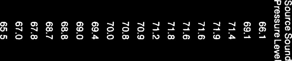

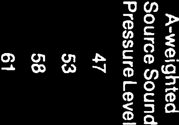

116
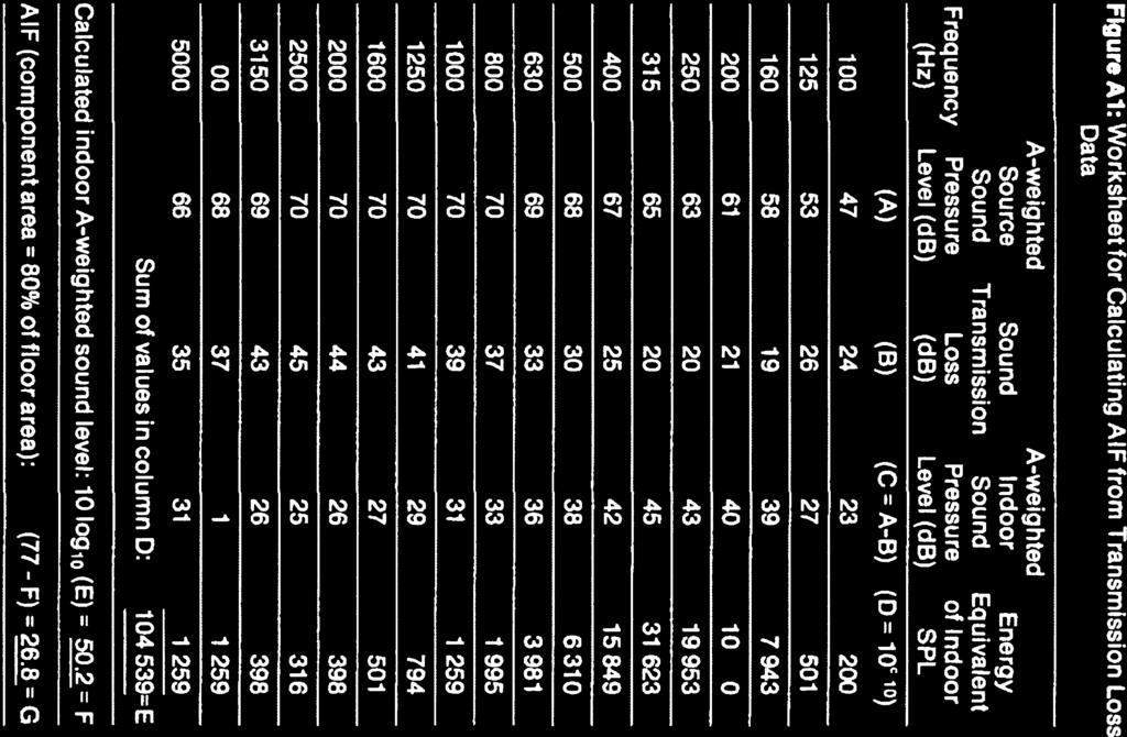

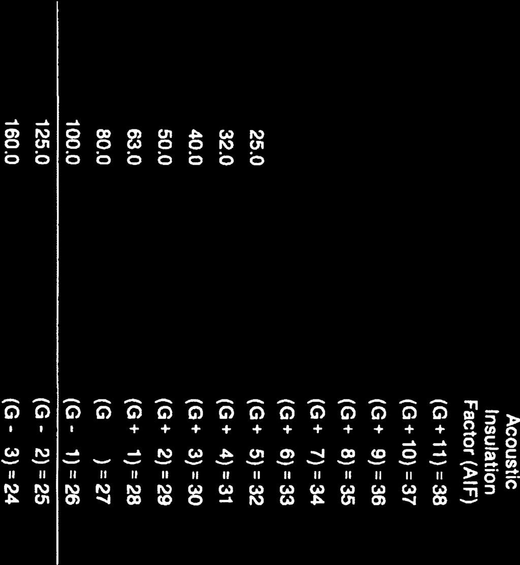


117
NOISE CONTROL FEASIBILITY STUDY. MINTO COMMUNITIES INC. Clarke Lands CITY OF OTTAWA
 NOISE CONTROL FEASIBILITY STUDY MINTO COMMUNITIES INC. Clarke Lands CITY OF OTTAWA March 2016 Prepared for: Minto Communities Inc. 200-180 Kent Street Ottawa, Ontario K1P 0B6 Prepared by: J.L. RICHARDS
Noise Assessment Report
 Noise Assessment Report 176 Greenfield Avenue Prepared for: TC United Group Prepared by: Stantec Consulting Ltd. February 8, 2016 NOISE ASSESSMENT REPORT Introduction February 8, 2016 Table of Contents
NOISE CONTROL STUDY FOR PHOENIX HOMES 3654 & 3658 JOCKVALE ROAD APRIL 28, 2011 REV 1 TABLE OF CONTENTS 1.0 INTRODUCTION BACKGROUND...
 NOISE CONTROL STUDY PHOENIX HOMES 3654 & 3658 JOCKVALE ROAD APRIL 28, 2011 REV 1 NOISE CONTROL STUDY FOR PHOENIX HOMES 3654 & 3658 JOCKVALE ROAD APRIL 28, 2011 REV 1 TABLE OF CONTENTS 1.0 INTRODUCTION...
Mann Avenue Development 87 Mann Avenue Noise Control Study
 Mann Avenue Development 87 Mann Avenue Noise Control Study Prepared By: NOVATECH ENGINEERING CONSULTANTS LTD. Suite 200, 240 Michael Cowpland Drive Ottawa, Ontario K2M 1P6 August 13, 2013 Novatech File:
Avalon Encore Stage Tenth Line Road Infusion Terrace, Block 233 City of Ottawa Environmental Noise Impact Assessment
 Avalon Encore Stage 6 2336 Tenth Line Road Infusion Terrace, Block 233 City of Ottawa Environmental Noise Impact Assessment Prepared For: Minto Communities Inc. Prepared By: Robinson Land Development Our
Table of Contents... ii 1. Introduction... 1
 316 Somerset Street East SACL Project #SW18098 April 05, 2018 Page ii Table of Contents Table of Contents... ii 1. Introduction... 1 2. Noise Sources... 1 3. Noise Assessment Criteria... 1 3.1 Surface
NOISE IMPACT ASSESSMENT RIVERSIDE SOUTH PHASE 13 CITY OF OTTAWA
 NOISE IMPACT ASSESSMENT RIVERSIDE SOUTH PHASE 13 CITY OF OTTAWA February 2014 (Revised October 2014) (Revised December 2015) Prepared for: RIVERSIDE SOUTH DEVELOPMENT CORPORATION 2193 Arch Street Ottawa,
Noise Assessment Report Riverside Drive Phase I
 Noise Assessment Report - 2887 Riverside Drive Phase I Project # 160401333 Prepared for: Youth Services Bureau Prepared by: Stantec Consulting Ltd. Introduction Table of Contents 1.0 INTRODUCTION... 1
Noise Assessment Report
 Noise Assessment Report 19 & 23 Bachman Terrace Prepared for: Tega Homes Prepared by: Stantec Consulting Ltd. June 5, 2015 NOISE ASSESSMENT REPORT Table of Contents 1.0 INTRODUCTION... 1 1.1 PURPOSE OF
Roadway Traffic Noise Assessment Chapel Street. Ottawa, Ontario
 Roadway Traffic Noise Assessment 151-153 Chapel Street Ottawa, Ontario REPORT: GWE14-064 Noise Prepared For: Brad Caco Sun Life Financial Center, East Tower 3250 Bloor Street West, Suite 1000 Toronto,
Traffic Noise Assessment. 5 Orchard Drive. Stittsville, Ontario
 Traffic Noise Assessment 5 Orchard Drive Stittsville, Ontario REPORT: GWE18-014 - Traffic Noise Prepared For: Cody Campanale 1187 Bank Street, Suite 200 Ottawa, Ontario K1S 3X7 Prepared By: Joshua Foster,
NOISE IMPACT ASSESSMENT RIVERSIDE SOUTH PHASE 9-4 CITY OF OTTAWA
 NOISE IMPACT ASSESSMENT RIVERSIDE SOUTH PHASE 9-4 CITY OF OTTAWA November 2013 Prepared for: RIVERSIDE SOUTH DEVELOPMENT CORPORATION 2193 Arch Street Ottawa, Ontario K1G 2H5 Prepared by: J.L. RICHARDS
Merivale Road Residential Development 1683 Merivale Road Noise Control Study
 Merivale Road Residential Development 1683 Merivale Road Noise Control Study Prepared By: NOVATECH ENGINEERING CONSULTANTS LTD. Suite 200, 240 Michael Cowpland Drive Ottawa, Ontario K2M 1P6 Submitted:
Noise Feasibility Study EMGO (North Oakville I) Ltd., Town of Oakville, Ontario
 Ltd., Town of Oakville, Ontario") Noise Feasibility Study EMGO (North Oakville I) Ltd., Town of Oakville, Ontario For Emgo (North Oakville I) Ltd. 2173 Turnberry Road Burlington, ON L7M 4P8 Prepared by Victor Garcia, BASc Reviewed by Sheeba
Noise Feasibility Study EMGO (North Oakville I) Ltd., Town of Oakville, Ontario For Emgo (North Oakville I) Ltd. 2173 Turnberry Road Burlington, ON L7M 4P8 Prepared by Victor Garcia, BASc Reviewed by Sheeba
Prepared for: Gapatas Inc Sherwoodtowne Boulevard, Unit 106 Mississauga, ON L4Z 1Y5. Our File No:
 YARMOUTH HEIGHTS ESTATES PHASE IV PARTS 1,2,4,5 & 6 Plan 11R Being Part of Lot 9 Concession 8 Geographical Township of Yarmouth City of St. Thomas Prepared for: Gapatas Inc. 4255 Sherwoodtowne Boulevard,
Roadway Traffic Noise Assessment Montreal Road. Ottawa, Ontario
 Roadway Traffic Noise Assessment 807-825 Montreal Road Ottawa, Ontario REPORT: GWE15-086-TRAFFIC NOISE Prepared For: Anthony Nicolini 183 Michael Cowpland Drive Ottawa, Ontario K2M 0M3 Prepared By: Michael
Fayez & Patrizia Ghadban
 Noise Impact Assessment Study 826 Pinecrest Road Type of Document Site Plan Submission Project Name 826 Pinecrest Road, Ottawa Project Number Prepared By: 100-2650 Queensview Drive Ottawa, ON K2B 8H6 Canada
ENVIRONMENTAL NOISE ASSESSMENT
 ENVIRONMENTAL NOISE ASSESSMENT 2055 BROCK ROAD PROPOSED TOWNHOUSE DEVELOPMENT PART OF LOT 18, CONCESSION 2 CITY OF PICKERING PREPARED FOR: BROCK ROAD DUFFINS FOREST INC. Revised October 2017 December 2014
Roadway Traffic Noise Feasibility Assessment. Ironwood Subdivision. Ottawa, Ontario
 Ironwood Subdivision Ottawa, Ontario REPORT: GWE16-085 - Traffic Noise Prepared For: 2356349 Ontario Inc. 301 Moodie Drive, Suite 100 Ottawa, Ontario K2H 9C4 Prepared By: Joshua Foster, P.Eng., Partner
Traffic Noise Assessment. 333 Montreal Road. Ottawa, Ontario
 Traffic Noise Assessment 333 Montreal Road Ottawa, Ontario REPORT: GWE17-045 - Traffic Noise Prepared For: Michaela Jones The Salvation Army 2 Overlea Blvd Toronto, ON M4H 1P4 Prepared By: Joshua Foster,
Noise Feasibility Study Proposed Residential Development, 361 Tanbark Road Niagara-on-the-Lake, Ontario
 Noise Feasibility Study Proposed Residential Development, 361 Tanbark Road Niagara-on-the-Lake, Ontario Prepared for: Blythwood Homes Inc. 7058 Ridgewood Crescent Niagara Falls, Ontario L2J 3H1 Prepared
Guelph Curling Club Development Traffic Noise Impact Study
 Guelph Curling Club Development Traffic Noise Impact Study Development Location Prepared For: Guelph Curling Club Paradigm Transportation Solutions Ltd. 43 Forest Road Cambridge ON N1S 3B4 pgrubb@ptsl.com
DCR Phoenix. Type of Document 1st Submission. Project Name 256 Rideau Street Ottawa, Ontario. Project Number OTT A0. Prepared By: Nicole Ruyf
 DCR Phoenix Noise Impact Assessment Study Type of Document 1st Submission Project Name 256 Rideau Street Ottawa, Ontario Project Number OTT-00206641-A0 Prepared By: Nicole Ruyf Reviewed By: Alam Ansari,
Traffic Noise Assessment Baseline Road Ottawa, Ontario
 Traffic Noise Assessment 2140 Baseline Road Ottawa, Ontario REPORT: GWE18-047 Traffic Noise Prepared For: Joey Theberge 905 Lady Ellen Place Ottawa, Ontario K1Z 5L5 Canada Prepared By: Omar Daher, B.Eng.,
Noise Feasibility Study Proposed Residential Development Old Barber House 5155 Mississauga Road City of Mississauga, Ontario
 Noise Feasibility Study Proposed Residential Development Old Barber ouse 5155 Mississauga Road City of Mississauga, Ontario Prepared for: City Park (Old Barber) omes Inc. 950 Nashville Road Kleinburg,
ENVIRONMENTAL NOISE ASSESSMENT
 ENVIRONMENTAL NOISE ASSESSMENT STONEPAY - PICKERING WEST OF BROCK ROAD AND SOUTH OF DERSAN STREET PART OF LOTS 19 AND 20, CONCESSION 3 PLAN 40R-28764 CITY OF PICKERING PREPARED FOR: STONEPAY 7603860 CANADA
ENVIRONMENTAL NOISE ASSESSMENT
 ENVIRONMENTAL NOISE ASSESSMENT PROPOSED TOWNHOUSE BLOCKS 273 LIBERTY STREET BLOCKS 197 to 199, INCLUDSIVE REGISTERED PLAN 40M-2332 AND PART OF LOT 10, CONCESSION 2 MUNICIPALITY OF CLARINGTON (BOWMANVILLE)
Noise Assessment Report
 Noise Assessment Report 19 & 23 Bachman Terrace Prepared for: Tega Homes Prepared by: Stantec Consulting Ltd. March 24, 2014 Draft Mar 7 2014 Final Mar 24, 2014 NOISE ASSESSMENT REPORT Table of Contents
NOISE IMPACT ASSESSMENT FOR SITE PLAN APPROVAL 12 HAMILTON AVENUE NORTH OTTAWA, ON.
 NOISE IMPACT ASSESSMENT FOR SITE PLAN APPROVAL 12 HAMILTON AVENUE NORTH OTTAWA, ON. REPORT PREPARED FOR SURFACE DEVELOPMENTS 61 FOREST HILL AVE. OTTAWA, ON, K2C 1P7 September 15, 2016 16419 1 NOISE IMPACT
ENVIRONMENTAL NOISE ASSESSMENT
 ENVIRONMENTAL NOISE ASSESSMENT 3171 LAKESHORE ROAD WEST PROPOSED RESIDENTIAL DEVELOPMENT PART OF LOT 32, CONCESSION 4 SOUTH OF DUNDAS STREET AND BLOCK 79 REGISTERED PLAN M-257 TOWN OF OAKVILLE PREPARED
Noise Assessment Report Main Street, Residential Site Cambridge, ON
 Noise Assessment Report 825-875 Main Street, Residential Site Cambridge, ON Prepared for: 2536546 Ontario Inc. Prepared by: Stantec Consulting Ltd. 100-300 Hagey Boulevard Waterloo, ON N2L 0A4 Project:
Noise Feasibility Study Proposed Residential Building 103 Dundas Street West Oakville, Ontario
 Noise Feasibility Study Proposed Residential Building 103 Dundas Street West Oakville, Ontario Prepared for: 103 Dundas Corporation Attn: Zaki Wahbeh 2184 Providence Road Oakville, ON L6H 6Z2 Prepared
Noise Feasibility Study Stacked Townhouse Development Glenashton Drive (Block 55) Oakville, Ontario
 Oakville, Ontario") Noise Feasibility Study Stacked Townhouse Development Glenashton Drive (Block 55) Oakville, Ontario Prepared for: Nathan Jamieson, P.Eng Senior Principal, Community Development Stantec Consulting Ltd 300W
Noise Feasibility Study Stacked Townhouse Development Glenashton Drive (Block 55) Oakville, Ontario Prepared for: Nathan Jamieson, P.Eng Senior Principal, Community Development Stantec Consulting Ltd 300W
Noise Control Study. Proposed Mixed-use Development. 112 Montreal Road City of Ottawa. Prepared for: DCR Phoenix Developments
 Noise Control Study Proposed Mixed-use Development 112 Montreal Road City of Ottawa Prepared for: DCR Phoenix Developments August 2014 10-13081-001-N01 August 28, 2014 10-13081-001-N01 Michael Boucher
TRAFFIC NOISE IMPACT ASSESSMENT FOR THE PROPOSED MULTI-UNIT RESIDENTIAL DEVELOPMENT AT 20 MARK AVENUE
 Ottawa, Ontario, Canada TRAFFIC NOISE IMPACT ASSESSMENT FOR THE PROPOSED MULTI-UNIT RESIDENTIAL DEVELOPMENT AT 20 MARK AVENUE CITY OF OTTAWA Prepared for Prepared by Freefield Ltd. Issued: Postal Address:
NOVATECH ENGINEERING CONSULTANTS LTD. Suite 200, 240 Michael Cowpland Drive Ottawa, Ontario K2M 1P6
 RESIDENTIAL / HOTEL DEVELOPMENT 141 GEORGE STREET / 325 DALHOUSIE STREET OTTAWA, ONTARIO Prepared By: NOVATECH ENGINEERING CONSULTANTS LTD. Suite 200, 240 Michael Cowpland Drive Ottawa, Ontario K2M 1P6
Noise Control Study. for. Avalon Public School Portobello Boulevard at Stormwind Avenue in Ottawa, Ontario. Revision 1
 REP N45 Avalon School Traffic Noise Study - R1 Noise Control Study for Avalon Public School Portobello Boulevard at Stormwind Avenue in Ottawa, Ontario. Revision 1 Prepared for: N45 Architecture Inc. Prepared
NOISE IMPACT ASSESSMENT FOR SITE PLAN APPROVAL 47 HAVELOCK STREET OTTAWA, ON.
 NOISE IMPACT ASSESSMENT FOR SITE PLAN APPROVAL 47 HAVELOCK STREET OTTAWA, ON. REPORT PREPARED FOR SURFACE DEVELOPMENTS 61 FOREST HILL AVE. OTTAWA, ON, K2C 1P7 March 25, 2015 15078 1 NOISE IMPACT ASSESSMENT
Noise Control Feasibility Study 173 / 175 / 177 Preston Street Ottawa, Ontario
 Noise Control Feasibility Study 173 / 175 / 177 Preston Street Ottawa, Ontario Type of Document Site Plan Application Client 1536 Prince of Wales Drive, Ottawa, Ontario K2C 1P1 Project Number Prepared
ASSESSMENT OF THE TRAFFIC NOISE IMPACTS AT THE PROPOSED HOLIDAY INN DEVELOPMENT LOCATED AT 235 KING EDWARD AVENUE
 Ottawa, Ontario ASSESSMENT OF THE TRAFFIC NOISE IMPACTS AT THE PROPOSED HOLIDAY INN DEVELOPMENT LOCATED AT 235 KING EDWARD AVENUE CITY OF OTTAWA Prepared for Prepared by Hugh Williamson Associates Inc.
MINTO COMMUNITIES INC. HARMONY STAGE 2 PART OF 4025 STRANDHERD DRIVE NOISE CONTROL FEASIBILITY STUDY
 MINTO COMMUNITIES INC. HARMONY STAGE 2 PART OF 4025 STRANDHERD DRIVE NOISE CONTROL FEASIBILITY STUDY July 2017 Prepared for: MINTO COMMUNITIES INC. 180 Kent Street, Suite 200 Ottawa, Ontario K1P 0B6 Prepared
ASSESSMENT OF THE TRAFFIC NOISE IMPACTS AT THE PROPOSED RESIDENTIAL DEVELOPMENT 364 ST. PATRICK STREET
 Ottawa, Ontario ASSESSMENT OF THE TRAFFIC NOISE IMPACTS AT THE PROPOSED RESIDENTIAL DEVELOPMENT 364 ST. PATRICK STREET CITY OF OTTAWA Prepared for Prepared by Hugh Williamson Associates Inc. 7 th May 2013
NOISE IMPACT ASSESSMENT FOR SITE PLAN APPROVAL 47 HAVELOCK STREET OTTAWA, ON. REVISED with ADDENDUM for ROOFTOP OUTDOOR LIVING AREA
 NOISE IMPACT ASSESSMENT FOR SITE PLAN APPROVAL 47 HAVELOCK STREET OTTAWA, ON. REVISED with ADDENDUM for ROOFTOP OUTDOOR LIVING AREA REPORT PREPARED FOR SURFACE DEVELOPMENTS 61 FOREST HILL AVE. OTTAWA,
671 Victoria Road North City of Guelph Traffic Noise Study. Paradigm Transportation Solutions Limited
 671 Victoria Road North City of Guelph Traffic Noise Study Paradigm Transportation Solutions Limited February 2016 Project Summary Project Number 152315 February 2016 Client 1830334 Ontario Limited Client
ENVIRONMENTAL NOISE IMPACT ASSESSMENT THE MEADOWS IN HALF MOON BAY PHASE 5
 REPORT PROJECT: 115496-5.2.2 ENVIRONMENTAL NOISE IMPACT ASSESSMENT THE MEADOWS IN HALF MOON BAY PHASE 5 Prepared for TAMARACK HOMES by IBI GROUP APRIL 2018 IBI GROUP ENVIRONMENTAL NOISE IMPACT ASSESSMENT
REP Atelier 292 OCH Phase 2 Noise Study Page 1 of 26
 REP Atelier 292 OCH Phase 2 Noise Study Page 1 of 26 2016-10-13 Robert Matta Project Manager Atelier 292 Architect Inc. 292 Main Street, Ottawa, Ontario K1S 1E1 Tel: +1 (613) 231-2245 x154 Fax: +1 (613)
ENVIRONMENTAL NOISE IMPACT ASSESSMENT MCGANN 9a LANDS BANK STREET LEITRIM DEVELOPMENT AREA
 REPORT Project: 105202-5.2.2 ENVIRONMENTAL NOISE IMPACT ASSESSMENT MCGANN 9a LANDS - 4747 BANK STREET LEITRIM DEVELOPMENT AREA Prepared for Claridge Homes by IBI GROUP NOVEMBER 2017 IBI GROUP REPORT ENVIRONMENTAL
TABLE OF CONTENTS LIST OF TABLES
 TABLE OF CONTENTS INTRODUCTION... NOISE CRITERIA... Transportation Noise Sources... NOISE SOURCES... Transportation Sources... Stationary Noise Sources... PROJECTED SOUND LEVELS... VENTILATION AND WARNING
Noise Feasibility Study Proposed Residential Development Brock Road Pickering, Ontario
 Noise Feasibility Study Proposed Residential Development Brock Road Pickering, Ontario Prepared for: Madison Brock Limited 369 Rimrock Road Toronto, Ontario M3J 3G2 Prepared by: Jingyi Guo Reviewed by:
Noise Assessment & Control Transportation Noise Assessment 303 Lebreton Street South, 460 St. Laurent Boulevard Ottawa, Ontario Ottawa, Ontario
 Noise Assessment & Control Transportation Noise Assessment 303 Lebreton Street South, 460 St. Laurent Boulevard Ottawa, Ontario Ottawa, Ontario REPORT: GmE 13-051 - Traffic Noise - Final Prepared For:
NOISE IMPACT ASSESSMENT STUDY
 NOISE IMPACT ASSESSMENT STUDY Development Address: 765 Montreal Road Ottawa, Ontario City of Ottawa File Number: D07-12-18-0059 Client: Shepherds of Good Hope c/o: CSV Architects 402-1066 Somerset Street
UAL URBAN AERODYNAMICS LTD
 UAL URBAN AERODYNAMICS LTD 23 Waterford Drive Telephone (613) 225-6362 Ottawa, Ontario, Canada Facsimile (613) 225-3022 K2E 7V4 e-mail standen.ual@sympatico.ca website: http://www.urban-noise.ca 1.0 Background
REP Fotenn Bank Phase 1 Feasibility Noise Study with Building Component AmendmentPage 1 of 21
 REP Fotenn 890-900 Bank Phase 1 Feasibility Noise Study with Building Component AmendmentPage 1 of 21 2018-02-28 Emilie Coyle, M.Pl Planner Fotenn Planning + Design 223 McLeod St, Ottawa, ON K2P 0Z8 Office:
3.5.1 Outdoor Living Areas (OLAs) Indoor Sound Levels... 8
 Indoor Sound Levels... 8") RWDI was retained by Manor Park Management to conduct a traffic noise feasibility study as part of the Site Plan Approval (SPA) for the proposed development, to be located at the northwest corner of Vanier
RWDI was retained by Manor Park Management to conduct a traffic noise feasibility study as part of the Site Plan Approval (SPA) for the proposed development, to be located at the northwest corner of Vanier
ENVIRONMENTAL NOISE IMPACT ASSESSMENT 1208 OLD MONTREAL ROAD
 REPORT 109575-5.2.2.1 ENVIRONMENTAL NOISE IMPACT ASSESSMENT 1208 OLD MONTREAL ROAD CITY OF OTTAWA Prepared for DCR/PHOENIX HOMES by IBI Group February 9, 2018 IBI GROUP REPORT ENVIRONMENTAL NOISE IMPACT
Place Vanier Édifice AEFO
 Place Vanier Édifice AEFO Martineau Architecture Inc. + Smith Carter Architects & Engineers Inc. TRAFFIC NOISE ASSESSMENT 250 Montreal Road Gradient Microclimate Engineering Inc. Prepared by Thomas Couper,
Table of Contents. 174 Forward Avenue SACL Project #B7-170 Feb 22, Page ii
 Page ii Table of Contents 1. Introduction... 1 2. Noise Assessment Criteria... 1 2.1. Surface Transportation Noise Assessment Criteria... 1 2.2. Neighbouring Stationary Source Noise Assessment Criteria...
Noise Feasibility Study Proposed Hospice 2050 University Avenue East, Waterloo, Ontario
 Noise Feasibility Study Proposed Hospice 2050 University Avenue East, Waterloo, Ontario Prepared for: Hospice of Waterloo Region 298 Lawrence Avenue Kitchener, ON N2M 1Y4 Prepared by Sheeba Paul, MEng,
Environmental Noise Assessment 1020, 1024, 1028, 1032 & 1042 Sixth Line Oakville, ON
 Environmental Noise Assessment 1020, 1024, 1028, 1032 & 1042 Sixth Line Oakville, ON Novus Reference No. 16-0173 Version No. 1.0 (Final) September 30, 2016 NOVUS PROJECT TEAM: Specialist: Marcus Li, P.Eng.
Burnett Lands Greenbank Road. Noise Impact Feasibility Report
 Burnett Lands - 3370 Greenbank Road Noise Impact Feasibility Report BURNETT LANDS 3370 GREENBANK ROAD NOISE IMPACT FEASIBILITY REPORT Prepared for: Claridge Homes Prepared By: NOVATECH Suite 200, 240 Michael
Noise Feasibility Study, McGibbon Condominium 71 Main Street South Georgetown, Ontario
 Noise Feasibility Study, McGibbon Condominium 71 Main Street South Georgetown, Ontario Prepared for: Attn: Don Jackson Silvercreek Commercial Builders Inc. 66 Mill Street Georgetown, Ontario L5C 1V8 Prepared
Transportation Noise & Vibration Assessment Scott Street. Ottawa, Ontario
 Transportation Noise & Vibration Assessment 1946 Scott Street Ottawa, Ontario REPORT: GWE17 136 Noise & Vibration Prepared For: Michael Martin Construction Manager 88 Spadina Avenue Ottawa, ON K1Y 2C1
ENVIRONMENTAL NOISE IMPACT ASSESSMENT CLARIDGE HOMES MAPLE GROVE LANDS 1981 MAPLE GROVE ROAD KANATA WEST
 CLIENT LOGO REPORT PROJECT: 105205-5.2.2 ENVIRONMENTAL NOISE IMPACT ASSESSMENT CLARIDGE HOMES MAPLE GROVE LANDS 1981 MAPLE GROVE ROAD KANATA WEST Prepared for CLARIDGE HOMES by IBI GROUP FEBRUARY 2018
Brigil Homes. Noise Impact Assessment. Type of Document Site Plan Submission. Project Name Petrie s Landing, Phase 2. Project Number OTT A0
 Brigil Homes Noise Impact Assessment Type of Document Site Plan Submission Project Name Petrie s Landing, Phase 2 Project Number Prepared By: exp Services Inc. 100-2650 Queensview Drive Ottawa, ON K2B
ENVIRONMENTAL NOISE ASSESSMENT
 ENVIRONMENTAL NOISE ASSESSMENT LAKEVIEW BOULEVARD ENVIRONMENTAL ASSESSMENT LAKEVIEW BOULEVARD BETWEEN POPLAR AVENUE AND MAPLE AVENUE TOWN OF AJAX PREPARED FOR: TMIG February 2017 Y1610 TABLE OF CONTENTS
Draft Noise Abatement Guidelines
 Document under Separate Cover refer to IMLC01-13 Draft Noise Abatement Guidelines April 2013 Legislative & Planning Services Table of Contents 1.0 Introduction...1 1.1 Key Definitions...1 2.0 Existing
ACOUSTIC ASSESSMENT OF TRAFFIC NOISE IMPACTS ON THE PROPOSED AVALON CATHOLIC ELEMENTARY SCHOOL
 Ottawa Ontario Canada ACOUSTIC ASSESSMENT OF TRAFFIC NOISE IMPACTS ON THE PROPOSED AVALON CATHOLIC ELEMENTARY SCHOOL CITY OF OTTAWA Prepared for Bryden Martel Architects Inc. Prepared by Hugh Williamson
Appendix K. Environmental Noise Assessment
 Appendix K Environmental Noise Assessment ENVIRONMENTAL NOISE ASSESSMENT THORNTON ROAD NORTH TAUNTON ROAD WEST TO WINCHESTER ROAD WEST SCEDULE 'C' MUNICIPAL CLASS ENVIRONMENTAL ASSESSMENT CITY OF OSHAWA
Roadway Traffic Noise and Vibration Assessment. The Bridge Wesleyan Church Addition. Ottawa, Ontario
 Roadway Traffic Noise and Vibration Assessment The Bridge Wesleyan Church Addition Ottawa, Ontario REPORT: GWE14-103 Traffic Noise and Vibration Prepared For: Alan McCafferty The Bridge Kanata Wesleyan
Environmental Noise Assessment Montreal Road. Ottawa, Ontario
 Environmental Noise Assessment 1795 Montreal Road Ottawa, Ontario REPORT: GWE18-037 Environmental Noise Prepared For: Samantha Schneider Christopher Simmonds Architect Inc. 45 Eccles Street, The Annex
SS WILSON ASSOCIATES Consulting Engineers
 SS WILSON ASSOCIATES Consulting Engineers REPORT NO. WA10-089 DETAILED NOISE CONTROL STUDY PROPOSED 6-STOREY APARTMENT BUILDING 17, 19 & 23 ROBINSON AVENUE OTTAWA, ONTARIO SUBMITTED TO: ROBINSON PARK DEVELOPMENT
DRAFT Part 1: ENVIRONMENTAL NOISE CONTROL GUIDELINES FOR LAND USE PLANNING
 DRAFT Part 1: ENVIRONMENTAL NOISE CONTROL GUIDELINES FOR LAND USE PLANNING For further information please contact: Robin van de Lande, Planner Planning and Growth Management 110 Laurier Avenue West, 4th
Noise Feasibility Study 2120 Hurontario Street and Grange Drive City of Mississauga, Ontario
 Noise Feasibility Study 2120 Hurontario Street and Grange Drive City of Mississauga, Ontario For Gordon Woods Developments Limited c/o Edenshaw development Limited 260 Brunel Road Mississuaga, Ontairo
Noise Abatement Guidelines. Regional Official Plan Guidelines
 Noise Abatement Guidelines Regional Official Plan Guidelines Halton Region Official Plan Guidelines The Regional Official Plan (ROP) is Halton s guiding document for land use planning. It contains policies
DETAILED NOISE CONTROL STUDY OF PROPOSED PHASE 2 CONDOMINIUMS AT 655 & 755 ANAND PRIVATE OTTAWA Ontario Inc.
 Ottawa, Ontario, Canada DETAILED NOISE CONTROL STUDY OF PROPOSED PHASE 2 CONDOMINIUMS AT 655 & 755 ANAND PRIVATE OTTAWA Prepared for Prepared by Hugh Williamson Associates Inc. 13 August 2015 Postal Address:
Noise Feasibility Study Proposed 4 Storey Apartment Building 226 Woolwich Street South Breslau, Regional Municipality of Waterloo
 Noise Feasibility Study Proposed 4 Storey Apartment Building 226 Woolwich Street South Breslau, Regional Municipality of Waterloo Prepared for: RHH Rental Properties Inc. 6783 Wellington Road 34, RR22
Noise Feasibility Study Proposed Stacked Townhouse Development, 3060 and 3072 Sixth Line, Town of Oakville, Ontario
 Noise Feasibility Study Proposed Stacked Townhouse Development, 3060 and 3072 Sixth Line, Town of Oakville, Ontario Prepared for: 2457667 Ontario Inc. 3219 Yonge Street, Suite 365 Toronto, Ontario M4N
18 McArthur Avenue, Ottawa, Ontario Proposed Development Noise Study Report. Prepared for: Takyan Consulting By: ARCH-Nova Design Inc.
 18 McArthur Avenue, Ottawa, Ontario Proposed Development Noise Study Report Prepared for: Takyan Consulting By: ARCH-Nova Design Inc. Project # N-01-16 May 2016 18 McArthur Avenue - 1 - N-01-16 TABLE OF
Noise Feasibility Study Framgard Apartments (South Block) NW corner of Britannia Road and Regional Road 25 Town of Milton, Ontario
 NW corner of Britannia Road and Regional Road 25 Town of Milton, Ontario") Noise Feasibility Study Framgard Apartments (South Block) NW corner of Britannia Road and Regional Road 25 Town of Milton, Ontario Prepared for: Mattamy Homes Ltd. 433 Steeles Avenue East, Suite 110 Milton,
Noise Feasibility Study Framgard Apartments (South Block) NW corner of Britannia Road and Regional Road 25 Town of Milton, Ontario Prepared for: Mattamy Homes Ltd. 433 Steeles Avenue East, Suite 110 Milton,
Environmental Noise Assessment Feasibility Assessment 92 Plains Road East
 Environmental Noise Assessment Feasibility Assessment 92 Plains Road East Novus Reference No. 16-0006 Version No. 1.1 (Final) February 26, 2016 NOVUS PROJECT TEAM: Specialist: Marcus Li, P.Eng. 16/02/26
DRAFT REPORT. Boyne East Catholic Secondary School #3CSS. Noise Impact Study. Louis St. Laurent Avenue, Milton. SACL #SW18060A0 December 11, 2018
 DRAFT REPORT Boyne East Catholic Secondary School #3CSS Louis St. Laurent Avenue, Milton Noise Impact Study SACL #SW18060A0 Submitted to: Jeff Kenny Partner Strategy 4 Inc. 2620 Bristol Circle, Unit 100
23, 33 & 39 DEERFOX DRIVE NOISE CONTROL FEASIBILITY STUDY
 23, 33 & 39 DEERFOX DRIVE NOISE CONTROL FEASIBILITY STUDY Prepared for: Glenview Homes (Deerfox) Ltd. 190 O Connor Street, 11 th Floor Ottawa, Ontario K2P 2R3 Prepared By: NOVATECH Suite 200, 240 Michael
Stationary Noise Assessment. 70 Richmond Road. Ottawa, Ontario
 Stationary Noise Assessment 70 Richmond Road Ottawa, Ontario REPORT: GWE16 013 Stationary Noise Prepared For: Stephen Job 109 Atlantic Avenue, Suite 302B Toronto, Ontario M6K 1X4 Prepared By: Michael Lafortune,
Noise Feasibility Study Proposed Residential Development Kemsley Farm St. Thomas, Ontario
 Noise Feasibility Study Proposed Residential Development Kemsley Farm St. Thomas, Ontario Prepared for: Doug Tarry Limited 358 Elm Street St. Thomas, Ontario, N5R 1K1 Prepared by Victor Garcia, PEng Reviewed
R. BOUWMEESTER & ASSOCIATES
 R. BOUWMEESTER & ASSOCIATES Land Development Engineering 165 Browning Trail Barrie, Ontario, Canada L4N 5E7 tel/fax (705) 726-3392 rbouwmeester@rogers.com Development Engineering Environmental Noise Studies
Proposed Residential/Institutional Development Independent and Assisted Care Senior s Residence 190 Richmond Road Ottawa, ON K1Z 6W6
 PRELIMINARY ENVIRONMENTAL NOISE REPORT Project:. Proposed Residential/Institutional Development Independent and Assisted Care Senior s Residence Richmond Road Ottawa, ON KZ W Prepared for: Choice Properties
Transportation Noise & Vibration Assessment. Medical Council of Canada. Ottawa, Ontario
 Transportation Noise & Vibration Assessment Medical Council of Canada Ottawa, Ontario REPORT: GWE13-115 - Traffic Noise & Vibrations Prepared For: Derek Hardy 47 Clarence Street Ottawa, Ontario K1N 9K1
Environmental Noise Feasibility Assessment Proposed Guelph Woods Development Guelph, ON
 Environmental Noise Feasibility Assessment Proposed Guelph Woods Development Guelph, ON Novus Reference No. 12-0292C DRAFT (v2.2) February 7, 2014 NOVUS PROJECT TEAM: Specialist: Marcus Li, B.Sc., B.Eng.Sc.
Noise Feasibility Study 2480 Old Bronte Road, Oakville, Ontario
 Noise Feasibility Study 2480 Old Bronte Road, Oakville, Ontario Prepared for: New Horizon Development Group (Bronte) Inc. 69 John Street South, Suite 400 Hamilton, Ontario L8N 2B9 Prepared by Sheeba Paul,
Policy for the Assessment and Mitigation of Traffic Noise on County Roads
 Lanark County Policy for the Assessment and Mitigation of Traffic Noise on County Roads d r a f t f o r d i s c u s s i o n Prepared by: AECOM Canada Ltd. 302 1150 Morrison Drive, Ottawa, ON, Canada K2H
ENVIRONMENTAL NOISE CONTROL GUIDELINES: Introduction and Glossary
 ENVIRONMENTAL NOISE CONTROL GUIDELINES: Introduction and Glossary January 2016 Visit us: Ottawa.ca/planning Contents Introduction 1 Implementation and Interpretation 1 Structure of the Environmental Noise
1. Introduction Site Noise Impact... 1
 Mixed Use Development SACL Report #B4-077 April 11, 2014 Table of Contents 1. Introduction... 1 2. Site... 1 3. Noise Impact... 1 3.1. Noise Sources... 1 3.2. Critical Noise Receptors... 1 3.3. Noise Levels...
Noise Feasibility Study Proposed 6-storey Seniors Condominium 7480 Derry Road West Milton, Ontario
 Noise Feasibility Study Proposed 6-srey Seniors Condominium 7480 Derry Road West Miln, Ontario Prepared for: FGL Derry Inc. 5400 Yonge Street, Suite 300 Toron, Ontario M2N 5R5 Prepared by Vicr Garcia,
Stationary Noise Study. Stonebridge Golf and Country Club. Ottawa, Ontario
 Stationary Noise Study Stonebridge Golf and Country Club Ottawa, Ontario REPORT: GmE 09-042 Noise Prepared For: Kris Haynes 3584 Jockvale Road Ottawa, Ontario K2C 3H2 Prepared By: Thomas Couper, B.Eng.,
Noise and Vibration Feasibility Study 1 and 15 Stevenson St & 8 William St Guelph, Ontario
 Noise and Vibration Feasibility Study 1 and 15 Stevenson St & 8 William St Guelph, Ontario Prepared for: Jennark Homes 66 Wellington Road 7, Unit #1 Elora, Ontario N0B 1S0 Prepared by Rajjot Arora, BASc
Appendix M. Noise Assessment
 Appendix M Noise Assessment 610 Chartwell Road, Suite 300 Oakville, ON Canada L6J 4A5 t: 905.823.8500 f: 905.823.8503 www.mmmgrouplimited.com www.wspgroup.ca MEMO RE: FROM: DATE: March 27, 2017 COPIES:
TABLE OF CONTENTS 1.0 INTRODUCTION SITE AND AREA DESCRIPTION...1
 VALCOUSTICS CANADA LTD. File: 12-286-211 Milton Heights Neighbourhood Royal Park South/Milton Noise Feasibility TABLE OF CONTENTS 1. INTRODUCTION...1 1.1 SITE AND AREA DESCRIPTION....1 2. ENVIRONMENTAL
Traffic and Stationary Noise Feasibility Study Proposed Lakeside Village Plaza 5353 Lakeshore Road Burlington, Ontario
 Traffic and Stationary Noise Feasibility Study Proposed Lakeside Village Plaza 5353 Lakeshore Road Burlington, Ontario Prepared for: United Burlington Retail Portfolio Inc. 986 St. Clair Ave. W. Toronto,
APPENDIX A. 2. That the road allowances included in this draft plan shall be shown and dedicated as public highways.
 APPENDIX A FILE NO: 04-T-2008-01 The City of Cornwall s conditions and amendments to final plan approval for registration of subdivision File No. 04-T-2008-01 are as follows: NO. CONDITIONS 1. That this
The content of this supplement is based upon the that described in our letter of May 28, 2012.
 September 20, 2012 30 Wertheim Court, Unit 25 Richmond Hill, Ontario, Canada L4B 1B9 email solutions@valcoustics.com web www.valcoustics.com telephone 905 764-5223 fax 905 764-6813 Davis Howe Partners