Herkimer Oneida Counties Transportation Study Long Range Transportation Plan
|
|
|
- Barry Harris
- 6 years ago
- Views:
Transcription


1 Herkimer Oneida Counties Transportation Study Long Range Transportation Plan

2
3 DESTINATIONS 2030 Herkimer-Oneida Counties Long Range Transportation Plan TABLE OF CONTENTS PAGE Chapter 1 Introduction 1-1 Chapter 2 Vision, Goals and Objectives 2-1 Chapter 3 Plan Requirements 3-1 Chapter 4 Demographics 4-1 Chapter 5 Transit 5-1 Chapter 6 Highways and Bridges 6-1 Chapter 7 Canals 7-1 Chapter 8 Rail 8-1 Chapter 9 Aviation 9-1 Chapter 10 Bicycle and Pedestrian 10-1 Chapter 11 Financing the Plan 11-1 Chapter 12 Implementation 12-1 Appendix A Appendix B Appendix C Agency Consultation Public Participation Regional Transportation Needs
4 DESTINATIONS 2030 Herkimer-Oneida Counties Long Range Transportation Plan LIST OF MAPS AND FIGURES Page Map 1-1 Federal-Aid Highway System in Herkimer and Oneida Counties 1-2 Figure 3-1 Air Quality Impacts 3-9 Figure 3-2 Energy Consumption 3-9 Figure 3-3 Safe Routes to School Summary 3-11 Map 3-1 Floodzones and Wetlands 3-15 Map 3-2 Rare Plant and Animal Species 3-16 Map 3-3 Remediation Sites 3-17 Map 3-4 National Historic Registry Sites 3-18 Map 3-5 New York State Parks and State-Designated Historic Sites 3-19 Map 3-6 NYSDEC Managed Lands 3-20 Map 3-7 Agricultural Districts 3-21 Figure 4-1 Population Change, Map 4-1 Population Shift, Figure 4-2 Population Demographics for the HOCTS Planning Area 4-3 Figure 4-3 LEP Population, NYSDOT Region 2 by County 4-5 Figure 4-4 LEP Population, NYSDOT Region 2 by City 4-6 Map 4-2 New York State LEP Population by County 4-6 Map 4-3 LEP Populations in Oneida County 4-7 Figure 4-5 Population Projections, Figure 4-6 Mode Split, 1990 to Figure 4-7 Travel Time to Work, Figure 4-8 Travel Time to Work, Figure 4-9 Vehicle Miles Traveled (VMT) and Population Change, Figure 4-10 Employment-Related Travel Patterns 4-10 Figure 4-11 Employment Projections in the Mohawk Valley, Figure 4-12 Growth Occupations in the Mohawk Valley, Map 4-4 Empire Zone Sites in Oneida County 4-15 Map 4-5 Empire Zone Sites in Herkimer County 4-16
5 Map 5-1 Public Transit Routes 5-3 Figure 5-1 Estimated 20-Year Transit Capital & Operating Needs 5-7 Figure 5-2 Estimated 20-Year Transit Funding 5-7 Figure 6-1 Statewide Traffic Fatalities, Figure 6-2 Fatality Rates by County, Figure 6-3 Traffic Fatalities, Figure 6-4 Bicycle and Pedestrian Crashes in Oneida County, Figure 6-5 Bicycle and Pedestrian Crashes in Herkimer County, Figure 6-6 Highway Ownership by Mileage 6-6 Figure 6-7 FHWA Functional Classification 6-7 Figure 6-8 FHWA Functional Classification of Road Mileage by County 6-8 Map 6-1 Functional Classification of Roads 6-9 Figure 6-9 Summary of Miles by Condition, Figure 6-10 Condition of Road Surface by Percentage 6-11 Map 6-2 Pavement Conditions 6-12 Figure Bridge Conditions 6-13 Figure 6-12 Anticipated Freight Truck Increases, Map 7-1 Erie Canal National Heritage Corridor Eastern Region 7-3 Figure 8-1 Rail Needs in Oneida and Herkimer Counties 8-3 Figure 8-2 Status of Rail Projects 8-8 Figure 8-3 Planned Rail Improvements, Map 8-1 Industrial Properties within Active Rail Corridors 8-10 Figure 9-1 Regional Aviation Objectives 9-3 Figure 9-2 Griffiss International Airport Capital Improvement Funding, Map 10-1 Bicycle Routes, Multi-Use Trails and Connecting Roadways 10-3 Figure 10-1 Bicyclist Injuries and Deaths in the United States, Figure 10-2 Pedestrian Injuries and Deaths in the United States, Figure 11-1 Estimated Financial Resources, Figure 11-2 Estimated Financial Needs,
6 Chapter 1 Introduction The Herkimer-Oneida Counties Governmental Policy and Liaison Committee (GP&L) is the Metropolitan Planning Organization (MPO) for Herkimer and Oneida Counties and directs the regional transportation planning process as it relates to the use of federal transportation funds. The GP&L has final approval and authority on all major transportation decisions, policies, and programs developed through the Herkimer-Oneida Counties Transportation Study (HOCTS) planning process. HOCTS serves as staff to the GP&L to carry out the transportation planning process and works cooperatively with local, state, and federal agencies to conduct transportation planning activities in Herkimer and Oneida Counties. The GP&L is composed primarily of locally elected and appointed officials that represent the interests of the citizens of Herkimer and Oneida Counties, officials from the State of New York, transit providers, social services agencies and other stakeholders. Under federal legislation, MPOs are responsible for the planning and programming of federal transportation funds within the designated MPO Planning Area. Map 1-1 depicts the Federal-Aid Highway System which includes New York State highways and all federal-aid eligible roads and bridges in the HOCTS Planning Area. The planning process is guided by three documents: the annual Unified Planning Work Program (UPWP), the 5-year Transportation Improvement Plan (TIP) and the 20-year Long-Range Transportation Plan (LRTP) which is updated every 5 years. These documents are available online at The LRTP is developed as a guide or a blueprint for planning transportation system maintenance and improvements to address the current need and future demand. Developing and maintaining a complex transportation system consisting of highway, bridge, rail, transit, aviation, canal, bicycle and pedestrian facilities requires careful planning and decision making. HOCTS provides a public forum to address the transportation needs of the two-county area through its committee structure and adopted public outreach plan. The LRTP outlines goals, objectives and recommendations that address the transportation needs of the area to reflect changes in demographics, travel needs, economic conditions, technological improvements, environmental factors and land use patterns to appropriately program funding in accordance with state and federal requirements and in a manner that is consistent with local development plans. Destinations is consistent with the HOCTS mission to develop an integrated intermodal transportation system that facilitates the safe and efficient movement of people and goods. The LRTP has been developed in compliance with requirements of the Safe, Accountable, Flexible, Efficient Transportation Equity Act: A Legacy for Users (Public Law ; SAFETEA-LU) and funded with Federal Highway Administration (FHWA) and Federal Transit Administration (FTA) planning funds (FHWA-PL and FTA Section 5303). 1 1 US Department of Transportation Federal Highway Administration HOCTS 1-1 Chapter 1 Introduction
7 Map 1-1. Federal-Aid Highway System in Herkimer and Oneida Counties HOCTS 1-2 Chapter 1 Introduction
.")
8 Chapter 2 Vision, Goals, and Objectives The creation of the vision statement for the HOCTS Planning Area and the development of goals and objectives, conveys the framework and direction of the Long-Range Transportation Plan (LRTP). In the development of the LRTP, the goals and objectives are examined to determine their relevance to the current needs and issues of the community, as well as their adherence to current federal requirements. The vision, goals, and objectives are reflective of the planning factors defined in federal transportation legislation and address the needs of Herkimer and Oneida County residents. HOCTS VISION STATEMENT To develop an integrated intermodal transportation system that efficiently, conveniently, and reliably provides mobility networks that are responsive to the community s needs for safe and secure movement of people and goods Six priority areas have been established based on the LRTP Vision Statement: Land Use- Encourage compatibility with local and regional land use plans. Mobility & Accessibility- Improve safety and encourage coordination among transportation providers to address the diverse needs of the community for interconnectivity and accessibility. System Preservation- Promote a transportation system that compliments the area s natural and built environment. Economic Efficiency- Focus on low-cost, high-benefit projects that maximize return on capital investment. Environmental Impact- Minimize the potentially adverse impact of transportation projects on the community. Public Participation- Promote public access and input in the regional transportation planning process. HOCTS 2-1 Chapter 2 Vision, Goals, and Objectives
9 GOALS AND OBJECTIVES The LRTP is organized around the six general priority areas mentioned above that are reflective of the planning factors defined in the Safe, Accountable, Flexible, Efficient Transportation Equity 1 Act: A Legacy for Users (SAFETEA-LU). These priority areas guide current and future infrastructure investment, the LRTP goals outline the direction for the HOCTS Planning Area and the objectives identify strategies necessary to obtain the goals. LAND USE Municipal governments are empowered with a great deal of authority over local land use policy through the use of planning implements such as comprehensive/master plans, zoning or other regulatory ordinances that guide and control the types of development or land use that occurs in a community. Goal 1: Develop a transportation system which is compatible with the regional land use plan and local land use plans. Objectives: Provide transportation facilities and services in existing and new areas of development consistent with the regional land use plan and local land use plans. Extend public transportation services to areas with high ridership potential and the ability to support transit-supportive development patterns. Provide transportation improvements and services that will enhance regional tourism. Minimize transportation improvements that require significant impact on agricultural lands, historic sites, wetlands, endangered species and other sensitive environments. Improve access to commercial and industrial sites and regional employment centers as appropriate. 1 Safe, Accountable, Flexible, Efficient Transportation Equity Act: A Legacy for Users. Inter - governmental relations. 23 USC 101. HOCTS 2-2 Chapter 2 Vision, Goals, and Objectives
10 MOBILITY & ACCESSIBILITY Mobility and accessibility throughout the Mohawk Valley is important for economic development. Goal 2: Provide mobility and access among regional activity centers where it is efficient and necessary. Objectives: Coordinate with local governments to promote access management techniques. Engage in proactive environmental review. Implement ITS strategies and other remedies to alleviate congestion. Support multimodal development. Involve local governments early in the planning process. Ensure sufficient mobility and adequate access to places of work and to locations where goods and services may be obtained. Decrease travel time and cost by improving traffic operations and reducing congestion. Provide equitable distribution of public transportation service. Provide public transportation for disadvantaged residents. Expand inter-city and rural public transportation as appropriate and economically feasible.. Support long-term funding mechanisms to provide essential public transit. SYSTEM PRESERVATION Due to increasing financial constraints and demand for transportation improvements, it is essential that regional long-range planning efforts continue to focus on preservation, repair, and restoration of existing infrastructure. System preservation helps provide for a safe and efficient transportation system while making the most efficient use of limited resources. Additionally, supporting programs that reduce vehicle miles traveled (e.g., rideshare, welfare-to-work) will help preserve the current transportation system as will improving and maintaining non-vehicle related infrastructure. Goal 3: Ensure that capital investment in the transportation system makes the most efficient use of existing facilities, services and resources. Objectives: Operate and maintain transportation facilities and services at levels that will enhance user comfort, convenience, safety and security. Implement cost-effective improvements that reduce the frequency and severity of accidents. Encourage ridesharing and other energy conservation programs to lessen the total transportation system usage of scarce fuel supplies. HOCTS 2-3 Chapter 2 Vision, Goals, and Objectives
11 Reduce conflicts among transportation modes and services through coordination of operations and improvements. Maximize the efficient use of existing parking facilities. Improve circulation for bicyclists and pedestrians. Protect the capital investment in existing infrastructure and contribute to safety and stable traffic flow through state-of-good-repair maintenance. Pursue economic efficiency and effectiveness through promotion of and improved operation of the public transportation system. Encourage the continuation of operating assistance for public transportation to ensure adequate levels of service. ECONOMIC EFFICIENCY A primary focus of investment will continue to be on improving efficiency throughout the transportation system through low-cost and high-benefit improvements. This practical and responsible approach will involve evaluation of immediate needs and then make improvements that will insure that existing facilities provide safe, convenient and reliable transportation. Goal 4: Provide new transportation system improvements to address problems for which improvements to existing facilities are inadequate. Objectives: Meet future transportation needs by addressing spot congestion and system inefficiencies to maintain adequate service and accessibility levels. Maximize the net benefits obtained from investment in new facilities and services. Minimize the capital cost of providing new transportation facilities. Emphasize energy conservation in providing new transportation facilities. ENVIRONMENTAL IMPACT Protecting and preserving the integrity of our communities and natural environment is important to quality of life for residents of the region. Goal 5: Plan and develop a transportation system which stresses a proactive approach to identifying, avoiding and/or mitigating social, environmental and economic impacts. Objectives: Encourage transportation improvements that are located within existing rights-of-way. Minimize adverse effects of transportation facilities on residential and neighborhood character, community facilities, and displacement and relocation of individuals. Enhance public participation to insure that projects do not disproportionately affect minority and low-income populations. Reduce the adverse impacts of transportation projects on industrial and commercial areas. Minimize the adverse impacts of transportation facilities on environmentally and ecologically sensitive areas. Minimize the adverse impact of transportation system noise levels. Minimize the adverse impact on natural, historic, and archeological sites. HOCTS 2-4 Chapter 2 Vision, Goals, and Objectives
12 Promote projects that support the goals and objectives of the State Energy Plan. Coordinate mitigation efforts with natural resource agency partners. PUBLIC PARTICIPATION Public participation is an integral part of any planning process. HOCTS should continue to look for additional opportunities to reach out to diverse populations and also to investigate innovative communication tools to maximize participation. Goal 6: Ensure that the HOCTS transportation planning process is open, transparent and accessible to the community and attentive to the community's needs and concerns. Objectives: Adhere to the HOCTS Public Participation Plan which was developed in consultation with all interested parties and provides reasonable opportunities for comment throughout the transportation planning process. Provide reasonable opportunities for interested parties, including minorities, older adults, the disabled population, Limited-English Populations (LEP), and low-income residents to have their concerns considered in the planning process. Conduct public meetings at convenient and accessible locations, at convenient times and make public information available online. Ensure transparency in the transportation planning process and actively solicit input. PLANNING PRINCIPLES In order to guide decision makers, a set of planning and investment principles should be developed and approved by the GP&L committee. These principles will provide the framework for funding decisions, project selection and transportation priorities for the region. The principles will help decision makers reach collective desired outcome. HOCTS 2-5 Chapter 2 Vision, Goals, and Objectives
13 Chapter 3 Plan Requirements A turning point that brought surface transportation into the 21 st century and shaped the highway program to meet the nation s changing transportation needs was the passage of two successive federal transportation bills, the Intermodal Surface Transportation Efficiency Act of 1991 (ISTEA) and the Transportation Equity Act for the 21 st Century (TEA-21). The current federal transportation legislation, known as the Safe, Accountable, Flexible, Efficient Transportation Equity Act: A Legacy for Users (SAFETEA-LU) builds upon the previous Acts. SAFETEA-LU was enacted August 10, 2005 and expired on September 30, At the time of the adoption of this plan, new legislation has not been enacted by Congress. Federal Requirements Previous federal regulations required states and MPOs to develop and implement six management systems. The New York State Department of Transportation (NYSDOT), in cooperation with MPOs across the state, developed and incorporated the management systems into their transportation planning process. The NYSDOT and MPO planning processes must consider the transportation needs identified through the management systems in the development of long and short-range plans and programs. The six management systems are: Traffic congestion Pavement (Federal-Aid Highways) Bridges (on and off Federal-Aid Highways) Public Transportation Facilities and Equipment Safety Intermodal Transportation Facilities and Systems Planning Factors SAFETEA-LU addresses many issues in the transportation system, such as protecting the environment, increasing intermodal connectivity, stressing security, improving safety, reducing congestion, and improving freight movement. It also requires the LRTP to address eight planning factors, analyze current and future travel conditions and trends, identify existing and projected needs, ensure compliance with air quality standards and maintain fiscal constraint. SAFETEA-LU specifies the following eight planning factors which MPOs must consider: Support the economic vitality of the metropolitan area, especially by enabling global competitiveness, productivity, and efficiency. Increase the safety of the transportation system for motorized and non-motorized users. Increase the security of the transportation system. Increase the accessibility and mobility options available to people and freight. Protect and enhance the environment, promote energy conservation, improve quality of life. Enhance integration and connectivity throughout the transportation system, across and between modes for people and freight. Promote efficient system management and operation. Emphasize the preservation of the existing transportation system. HOCTS 3-1 Chapter 3 Plan Requirements
14 SAFETEA-LU builds on previous transportation legislation and includes new requirements related to long-range plan development for the MPO. These new requirements include: The LRTP will be updated at least every four years in non-attainment areas and at least every five years in attainment areas 1 Consideration of safety and security of the transportation system as separate planning factors in the metropolitan planning process Discuss with Federal, State, and tribal land management, wildlife, and regulatory agencies potential environmental mitigation activities and potential areas to carry out these activities, including activities that may have the greatest potential to restore and maintain the environmental functions affected by the transportation plan Development of funding estimates that will be available to support plan implementation must be a cooperative effort among MPOs, State DOTs and transit operators Consult with State and local agencies responsible for land use management, natural resources and environmental protection, conservation and historic preservation concerning the development of the plan. Consultation shall compare transportation plans with the plan, maps, inventories, and planning documents developed by other agencies The long range plan shall include operational and management strategies to improve the performance of existing transportation facilities to relieve congestion and maximize the safety and mobility of people and goods Protect and enhance the environment, promote energy conservation, improve the quality of life, and promote consistency between transportation improvements and State and local planned growth and economic developments patterns Representatives of users of pedestrian walkways, bicycle transportation facilities, and the disabled are specifically added as parties to be provided with the opportunity to participate in the planning process The MPO is to develop a participation plan in consultation with interested parties that provide reasonable opportunities for all parties to comment To carry out the participation plan, public meetings are to be conducted at convenient and accessible locations and times, and make public participation available in an electronically accessible format. Publish the LRTP in an electronically accessible format Air Quality The Clean Air Act as amended in August 1990 established various Federal, State and local requirements aimed at the expeditious attainment of national air quality standards. The Herkimer- Oneida Counties Region continues to meet transportation air quality standards and is still designated an attainment area. 2 The LRTP update will be integrated with the regional air quality planning process and will be consistent with the State Implementation Plan (SIP) and State Energy Plan. Americans with Disabilities Act The Americans with Disabilities Act (ADA) of 1990 made it illegal to discriminate against anyone 1 Herkimer and Oneida Counties are designated as attainment areas under federal Clean Air Act standards. 2 US EPA, HOCTS 3-2 Chapter 3 Plan Requirements
15 who has physical or mental disabilities in the areas of employment, public services, public accommodations and telecommunications. The passage of the ADA Amendments Act (ADAAA) of 2008 was intended to overturn a series of Supreme Court decisions that interpreted the ADA in a way that made it difficult to prove that an impairment is a disability. 3 The ADAAA makes significant changes to the ADA s definition of disability that broadens the scope of coverage under both the ADA and Section 503 of the Rehabilitation Act. For LRTP purposes, the needs of this targeted constituency, especially in respect to the counties aging population, are taken into consideration. New transit vehicles and facilities are required to be fully accessible. All buses planned and programmed in HOCTS Transportation Improvement Program (TIP) are lift-equipped. HOCTS staff is making every effort to plan for and include the needs of the disabled population in the planning process. Environmental Justice On February 11, 1994, President Clinton issued Executive Order concerning Environmental Justice. Environmental justice focuses on the human health conditions of minority and low-income communities and requires agencies to address environmental issues as part of their mission. In response, HOCTS developed an Environmental Justice Plan which is meant to ensure compliance with the order. 4 An important component of environmental justice is to use the public participation process as an opportunity to insure that minority and low-income populations are well informed about transportation issues and are not disproportionately affected by transportation projects. During the LRTP development, HOCTS held public meetings within the Planning Area where the largest percentage of minority and low-income populations reside. Additionally, HOCTS staff reached out to various community groups to solicit input for the LRTP. HOCTS will be updating the Environmental Justice Plan in the first part of Public Participation The goal of the HOCTS public participation process is to solicit early and continuous involvement of all interested parties of the community, which include minorities, elderly, and low-income people, and to ensure that the public has equal opportunity to provide input to express their opinions on transportation issues. The HOCTS Public Participation Plan Update, which was adopted by the GP&L in 2007, is a formal policy that guides the public participation process for all transportation planning documents of the MPO, including the LRTP. The Public Participation Plan is available on the HOCTS website, and upon request from the HOCTS office. Public participation for the LRTP was solicited through a variety of methods, which included direct mailings, press releases to area newspapers, TV, and radio stations; an online survey; and public meetings. Periodically, citizen groups and government officials have been informally convened to provide staff with input on the LRTP. HOCTS maintains a home page on the internet where the public can obtain information on public participation opportunities. All HOCTS committee meetings are open to the public and are announced in local newspapers, on 3 ADA Amendments Act of USC See also, - USDOT/FHWA Order on Environmental Justice. HOCTS 3-3 Chapter 3 Plan Requirements
16 local television and radio stations, and on the HOCTS website. The LRTP public meeting dates and locations are listed below and public comments are summarized in the Appendix. HOCTS Transportation Planning Committee (TPC) September 24, 2009 HOCTS Governmental Policy & Liaison Committee (GP&L) September 29, 2009 Herkimer County Community College - July 27, 2009 Utica City of Utica Common Council - July 28, 2009 Rome - City of Rome Council Chambers - July 30, 2009 Security and Disaster Planning In response to the terror attacks of September 11, 2001, MPOs have been directed by the current federal legislation to address security issues with transportation infrastructures within the context of the transportation planning and programming process. Security is one of five Priority Results Areas (PRAs) identified in NYSDOT s, Strategies for A New Age: New York s Transportation Plan for The State s overall goal for security is to develop, maintain and implement effective incident/emergency management practices that will address preparedness, mitigation, response, and recovery for both natural and human-cause disasters. The State s plan identifies a number of strategies to meet this goal and also identifies examples of specific strategies that the State will pursue to improve security at priority facilities. Emergency management and evacuation planning is led by county, municipal and local governments, and transit operators who are responsible for preparing plans for their respective areas in case of natural or man-made disasters. Valued Assets The region contains a number of assets that are critically important to not only the region but also the state and the nation. These assets include the NYS Thruway, CXS rail line with freight and passenger service (AMTRAK), Erie Canal, Clark Energy Center, Buckeye Oil Pipeline, Griffiss International Airport, the Rome Train Station, Union Station in Utica, and the transit systems. MPO Roles Relating to Phases of Security Incidents A report entitled, The Role of the Metropolitan Planning Organization (MPO) In Preparing for Security Incidents and Transportation System Response, prepared by the Georgia Institute of Technolog, addresses the role of the MPO in security/disaster situations. Recently, the Federal Highway Administration and many other groups have been looking closely at institutional strategies for providing metropolitan-level coordination of transportation system operations including the role of the MPO in such coordination. The Association of Metropolitan Planning Organizations (AMPO) has developed a technical paper on the range of roles for MPOs in planning for system operations. Traditional: The MPO incorporate system management and operations (M&O) Role: in its ongoing transportation planning activities. The focus would be on specific M&O projects that arise as part of the transportation planning process; but the primary responsibility for operations-type projects would rest elsewhere, most likely with the region s operations agencies. HOCTS 3-4 Chapter 3 Plan Requirements
17 Convener: Champion: Developer: Operator: The MPO would act as a forum where operations plans could be discussed and coordinated with other plans in the region. Regular meetings on operations issues would be held, but the MPO would still not be responsible for developing a regional operations plan. The MPO works aggressively to develop a regional consensus on operations planning. MPO planners work with operating agencies to create programs and projects that improve system performance. The MPO takes the lead in developing regional agreements on coordinated operations. The MPO would develop regional operations plans in addition to incorporating operations strategies into the transportation plan. System-oriented performance measures would be used to identify strategic operations gaps in the transportation system. The MPO would be responsible for implementing operations strategies that were developed as part of the MPO-led planning process. Given the MPO s strengths in technical analysis and transportation planning, the actions that seem most appropriate for HOCTS in the context of security/disaster planning would fall under the traditional role. The following is a list of security related findings for the HOCTS planning area: Centro of Oneida has a security plan and drivers receive security and disaster training. Buses are equipped with security cameras. Birnie Bus Service has a security plan. Birnie rural and over the road buses are not equipped with security cameras. Oneida County has a comprehensive emergency management plan to enhance the County s ability to manage emergency and disaster situations. Herkimer County also has a comprehensive emergency management plan. Union Station has security guards and a county sheriff is located at the station. There are cameras viewing the tracks but no cameras in or around the station. The Rome Station does not have security cameras. Region 2 NYSDOT has a traffic operations center that monitors a variety of information systems including weather and road conditions, road closures, and portable cameras for special events. The New York State Office of Homeland Security has established a state Disaster Preparedness Training Center at the Oneida County Airport. The purpose of the site is to coordinate WMD/Terrorism Training throughout the State to ensure the highest level of preparedness for first responders. The center recently received a number of retired buses from Central New York Regional Transit Authority (CNYTRA) for transit security training. Primary responsibility for security and disaster operations rests with each operating agency. The following is a list of security related recommendations for the HOCTS planning area: All public transit buses and transit facilities should be equipped with surveillance systems. Union Station and Rome Train Station should be equipped with surveillance systems. Major travel corridors should be considered for message boards and surveillance systems. HOCTS should gather data, and provide modeling and GIS services for other agencies in support of security and disaster planning. HOCTS 3-5 Chapter 3 Plan Requirements
18 HOCTS should reach out to other agencies and establish working relationships to create a sense of mutual support and benefit for security and disaster planning. State Master Plan In the summer of 2006, the Commissioner of the New York State Department of Transportation (NYSDOT) announced the New York State s official transportation plan, Strategies for a New Age: New York State s Transportation Master Plan for The Plan articulates a seamless system in which travelers can shift between modes to complete trips. The Plan outlines policy guidance and strategies to reach this vision. The master plan serves as the federally recognized long range transportation plan for New York State pursuant to federal law, satisfying SAFETEA-LU requirements, and in accordance with State Transportation Law. 6 The Plan serves as a framework for preparing future, more project-specific transportation plans and programs including the federally required State Transportation Improvement Program (STIP). The Plan is organized around the five interrelated themes: 1. Mobility and Reliability: Discusses the need for the State and its many diverse transportation providers to integrate transportation systems effectively, manage system congestion to adequately maintain predictable, efficient, and safe travel. The focus will be on managing transportation assets with the goal of achieving a state of good repair for all modes. 2. Safety: Discusses one of the primary goals of the statewide transportation master plan: to provide safe travel and reduce system safety deficiencies across all modes of travel for people and goods movement. 3. Security: Includes planning for the prevention and protection of the transportation system and the need for emergency plans to mitigate the effects and speed recovery from natural disasters or malicious activities. 4. Environmental Sustainability: Presents a broad understanding and commitment that environmental and energy use considerations must be fully integrated with sound transportation planning and investment strategies while in alignment with the goals of the State Energy Plan and Federal clean air requirements. 5. Economic Competitiveness: Examines how transportation investments can both strengthen the State s competitive economic position and support a sustainable economy and desired quality of life for citizens and communities. HOCTS will address many of these issues in its short-range and long-range planning activities. For example, HOCTS will assist in prioritizing regional infrastructure needs. State Energy Plan Reducing pollution and increasing energy efficiency for New York's transportation system is an integral part of the New York State Energy Plan. According to New York State Energy Research TRA, Article 2, Sec. 15 HOCTS 3-6 Chapter 3 Plan Requirements
19 and Development Authority (NYSERDA), on August 10, 2009 NYSERDA released the Draft 2009 New York State Energy Plan. The Draft Plan envisions a robust and innovative Clean Energy Economy that will stimulate investment, create jobs, and meet the energy needs of residents and businesses over its 10-year planning outlook. 7 Five strategies are outlined in the Plan to achieve multiple policy objectives. One strategy, Invest in Energy and Transportation Infrastructure, is of interest to the development of the HOCTS LRTP. The State s Plan cites that New York s massive energy and transportation infrastructure is in constant need on maintenance and repair to keep the State from backsliding on its high standards of infrastructure reliability. Infrastructure investments are also necessary to support the State s transition to a Clean Energy Economy, and will be driven by strategic longer-term needs, including the need to reduce greenhouse gas (GHG) emissions. One of the recommendations of this Plan is to develop a Climate Action Plan in accordance with Executive Order No. 24 to identify strategies, actions and infrastructure needs to reduce GHG emissions by 80 percent by Transportation investments can be used strategically to reduce vehicle congestion, expand mass transit and encourage more efficient transportation systems. Smart Growth The State is developing a comprehensive Climate Smart Communities Guide that will provide detailed information to help communities develop and implement climate-smart practices. The program emphasizes the importance of community awareness of their contributions to GHG emissions and action in reducing GHG emissions and adapting to climate change. The comprehensive planning process can help communities integrate their climate goals in a way that aligns with their land use goals. Specific to foster Smart Growth Upstate, additional investments in rapid transit bus service and associated improvements are needed in transit intensive corridors. Recommendations Revise the City, Town, Village, and General Municipal Laws to incorporate energy considerations in Comprehensive Plans. Revisions should be made to explicitly identify energy components that would engage communities in helping to meet the State s energy goals. Enact Tax Increment Financing reform legislation to encourage the redevelopment of distressed communities and revitalize downtown areas as recommended by the Governor s Smart Growth Cabinet. Collaborate with Metropolitan Planning Organizations, regional planning councils, and municipal governments to promote and incentivize land use patterns that reduce reliance on vehicle trips and establish consistency between transportation planning and land use planning. Provide technical assistance and funding opportunities via State grant programs for localities that incorporate land use, transportation, and energy planning. Encourage municipalities to adopt land use and zoning tools that support Smart Growth. Air Quality and Energy Use Analysis and report provided by NYSDOT, Region 2 staff HOCTS 3-7 Chapter 3 Plan Requirements
20 To meet the recommendations of the current (2002) State Energy Plan and the Clean Air Act as amended in 1990, HOCTS has evaluated the impacts of the policies and projects discussed in this Long-Range Plan on air quality and energy use in the region. Air quality impacts for transportation are measured by emissions of Volatile Organic Compounds (VOCs, otherwise known as smog), Nitrogen Oxides (NOx), and Carbon Monoxide (CO), as these are the major pollutants produced by automobiles and trucks. This analysis was done using the region s highway system and modeling tools assuming three possible scenarios to illustrate the change in VOC, NOX and CO over the twenty-year period of this Plan. The following scenarios were evaluated to estimate emissions and energy use for 2030, the horizon year of this Plan: 1) Existing highway system with no projects that might significantly impact air quality and/or energy use if implemented. 2) Existing highway system with projects that might significantly impact air quality and/or energy use if implemented. These include projects that will add travel lanes for more than a mile, upgrade or coordinate the traffic signals at 10 or more signalized intersections, change vehicle miles of travel by 10% or more if implemented, or significantly change or build a new interchange on an access controlled highway. Specifically, the following projects were included in the analysis of this alternative: PIN Project Description / Title Installation of Utica Traffic Signal System Traffic Signal Modernization: Genesee Street at Oneida Square (Utica) Rt 5/8/12(N-S Arterial) 1:Burrstone Rd-Oriskany Circle Mitigation Rt 5/8/12(N-S Arterial) 2:Burrstone Rd-Oriskany Circle, Stage Rt 5/8/12(N-S Arterial) Stage 3 3) The highway system and projects listed in #2 above, plus the support, encouragement, and enhancement of trip reduction measures that could reduce greenhouse gas emissions and energy use. These measures might include incentives that encourage greater use of public transportation, walking, and bicycling or carpooling, and encouraging the redevelopment of existing brownfields. These measures are consistent with the State s energy plan, transportation plan, and the recommendations discussed in this plan. Furthermore, these trip reduction measures will be promoted by such projects as CENTRO Common Center and the North South Arterial project, both of which are currently programmed. These three alternatives were compared to current (2010) conditions. The analysis described above indicates that while vehicle miles traveled (VMT) will increase by 2030 under all three alternatives, alternative three will result in the lowest VMT, energy used for transportation, and vehicle emissions for the horizon year (2030). In comparison to the null (do nothing) alternative, VMT is expected to be almost 6% lower in 2030 if travel reduction measures are implemented in conjunction with our projects. Under this alternative, VOC and NOx emissions would also be reduced more than if we do nothing (alternative 1) or only implement our projects (alternative 2), and CO emissions would increase the least. Finally, direct energy consumption defined as the energy consumed by vehicles using our highways - would be the lowest under alternative 3, increasing by about 10% over the 20 year period of HOCTS 3-8 Chapter 3 Plan Requirements
21 the Plan rather than 16% under alternative 1 and 14% under alternative 2. This is summarized in figures 3.1 and 3.2 Figure 3-1. Air Quality Impact Scenario Annual Daily Vehicle Miles of Travel (DVMT) Percent Change from 2010 *Emission Rates are based on MOBIL 6.2 Emissions Factor Table Part A Figure 3 2. Energy Consumption Scenario Volatile Organic Compounds (VOCs) Emmissions (grams/mile) Percent Change from 2010 Nitrogen Oxides (Nox) Emmissions* (grams/mile) Percent Change from 2010 Carbon Percent Change Monoxide (CO) from 2010 Emmissions* (grams/mile) NULL ,816, ,998, ,854, ,415, NULL ,303, % 1,854, % 1,495, % 101,823, % 2030 plus 9,322, % 1,787, % 1,527, % 104,013, % programmed projects 2030 plus programmed projects and various travel reduction measures 9,042, % 1,734, % 1,481, % 100,892, % Annual Daily Vehicle Miles of Travel (DVMT) Miles per Gallon (Daily) Total Direct Energy Consumption (BTU) Percent Change from 2010 NULL ,816, ,620,535, NULL ,303, ,102,370, plus programmed 9,322, ,368,063, projects 2030 plus programmed projects and various travel reduction measures 9,042, ,187,023, It is important to note that some of the projects that may have a significant impact on the area's air quality and direct energy use are still in the planning/formative stages. As a result, we can't accurately estimate how much they would change the emissions or energy consumption that have been estimated for the scenarios analyzed above. As more design specific information becomes available, more detailed analyses will be performed. Furthermore, through the National Environmental Policy Act (NEPA) & State Environmental Quality Review (SEQR) processes, the impact of "regionally significant" projects on air quality and energy consumption will be evaluated in detail as each project progresses. However, this preliminary analysis indicates that the projects and recommendations put forth in this Plan will foster the State s and Nation s goals of reducing greenhouse gas emissions and energy consumption. HOCTS 3-9 Chapter 3 Plan Requirements

22 Special Transportation Programs Transportation Enhancement Program The Transportation Enhancement Program (TEP) provides funding opportunities to help expand transportation choices and enhance the transportation experience through 12 eligible categories related to surface transportation, including pedestrian and bicycle infrastructure and safety programs, scenic and historic highway programs, landscaping and scenic beautification, historic preservation, and environmental mitigation. Projects funded by TEP projects must relate to surface transportation and must qualify under one or more of the 12 eligible categories 9. Two rounds of TEP funding were awarded by NYSDOT under SAFETEA-LU. Since 2006, $6.85M has been awarded to communities across Herkimer and Oneida Counties. The federal funds have been matched by local contributions exceeding $3M resulting in a nearly $10M investment in TEP eligible activities. Due to the fact that a reauthorized transportation bill has not been approved in time for the publication of this LRTP it is uncertain what level of funding will be available for enhancement projects. Safe Routes to School Safe Routes to School (SRTS) is a federal, state and local effort to enable and encourage children, including those with disabilities, to walk and bicycle to school and to make walking and bicycling to school safe and appealing. Local governments, school districts and non-profit organizations ready, willing and able to implement SRTS initiatives are eligible for funding under this program. The goal of New York's Safe Routes to School Program is to assist New York communities in developing and implementing projects and programs that encourage walking and bicycling to school while enhancing the safety of these trips. A single round of funding was awarded by NYSDOT under SAFETEA-LU. The program is administered by the NYSDOT Regional offices. In NYSDOT Region 2, a committee was established to review, rank and suggest for funding the most competitive of the 11 applications received in $697,610 in SRTS funds were awarded to fund 6 projects in the 6 County NYSDOT Region. Of these awards, two school districts Whitesboro and Oriskany in Oneida County and one district Owen D. Young in Herkimer County received funding. 10 Figure 3-3 outlines the funding applied for and awarded in the HOCTS Planning Area. 9 USDOT, FHWA: 10 NYSDOT: HOCTS 3-10 Chapter 3 Plan Requirements
23 Figure 3-3. Safe Routes to School Summary Location Project Costs SRTS Funds SRTS Funds Requested Awarded City of Rome (OC) $327,359 $327,359 $0 Whitesboro Central School District (OC) $96,539 $93,039 $93,039 Oriskany Central School District (OC) $458,346 $109,500 $109,500 Village of Whitesboro (OC) $67,985 $67,985 $0 Village of New York Mills (OC) $50,000 $50,000 $0 Owen D. Young Central School District (HC) $107,535 $99,735 $99,735 Village of Dolgeville (HC) $187, ,376 $0 Oneida County $1,000,229 $647,883 $202,539 Herkimer County $294,911 $272,111 $99,735 HOCTS Total $1,295,140 $919,994 $302,274 Scenic Byways Program The National Scenic Byways Program was established under ISTEA in 1991 and has continued under TEA-21 and SAFETEA-LU. For a route to be eligible for inclusion in the National Scenic Byways Program it must possess one or more of six intrinsic qualities; scenic, natural, historic, cultural, archeological or recreational. It must also have broad-based local community support for its designation, and have a management plan. The New York State Scenic Byways Program applies for federal funding for important State Scenic Byways Projects that promote tourism across the state, and provide physical improvements to existing State Scenic Byways. New York Stare projects approved for funding include the Adirondack North Country Scenic Byways interpretive map and a model video highlighting the 11 Adirondack North Country Scenic Byways. Federal grant monies were also received by the state to develop the Revolutionary Trail Scenic Byway from Amsterdam to Rome, and the Heartland Trail, NYS Route 20, which crosses the state. Herkimer and Oneida Counties have several NYS designated Scenic Byways that begin or pass through one or both counties, including: Southern Adirondack Trail: 112 miles. Begins in Little Falls and Herkimer at Thruway exits 29A and 30, respectively. From Little Falls travels north on Rt. 169 to Middleville, with a loop up into Dolgeville and Salisbury on Rt. 167 to Rt. 29 down into Middleville, and from Herkimer follows Rt. 28 to Middleville; continues north on Rt. 28 to Poland, where it turns onto Rt. 8 to Speculator in Hamilton County. Since being designated in 2003, the Southern Adirondack Trail has been awarded two grants through the Scenic Byways program to fund projects in Herkimer County. HOCTS 3-11 Chapter 3 Plan Requirements
24 Revolutionary Byway: 158 miles. Travels Rt. 5 beginning in Schenectady, through Herkimer and part of Oneida County, where it turns onto Rt. 49 to Rome, then follows Rt. 69 to Camden, then Rt. 13 to Port Ontario in Oswego County. Central Adirondack Trail: 140 miles. Begins in Rome at the terminus of Rts. 46, 49 and 69 with Rt It follows Rt. 365 north to join Rts. 12 and 28 north, where it continues across the State on Rt. 28 to Rt. 9 into Glens Falls in Saratoga County. Black River Trail: 111 miles. Begins in Rome, also at the terminus of Rts. 46, 49 and 69, then follows Rt. 46 north to Rt. 12, to Rt. 812, to Rt. 11 and back to Rt. 812 to Ogdensburg. Rt. 20 Scenic Byway: 110 miles. The portion of Rt. 20 beginning in Lafayette in Onondaga County and ending in Duanesburg in Schenectady County, passing through the southernmost portions of Oneida and Herkimer counties. This Byway has been recommended for State Scenic Byway Designation by the NYS Scenic Byways Advisory Board to the NYS Legislature. Official designation should take place in The New York State Scenic Byways program is overseen by DOT and is modeled after the National Scenic Byways program. New York State markets its scenic byways through the "I Love NY" Program. Scenic byways are road corridors that are of regionally outstanding scenic, natural, recreational, cultural, historic or archaeological significance. They encourage economic development through tourism and recreation. They offer an alternative travel route to the major highways and are managed to protect their outstanding character. As part of this LRTP, HOCTS supports regional Scenic Byways projects which are included in the New York State Scenic Byways Program. Environmental Impact Mitigation HOCTS and NYSDOT Region 2 are engaged in environmental mitigation activities at the planning and project level through the implementation of NEPA and SEQRA regulations, as well as context sensitive solutions to address environmental, scenic, aesthetic, historic, and natural resources. Environmental mitigation is a major consideration in corridor studies, grant applications, design reports and in project implementation. In Herkimer and Oneida Counties, mitigation activities are developed by and through various federal agencies, state and regional partnerships, and nongovernmental organizations. HOCTS and NYSDOT Region 2 have long recognized the relationship between the built and natural environment and the transportation system. Collaboration among agencies ensures that the implementation of the Long-Range Transportation Plan does not negatively impact or disrupt the environment. HOCTS outreach includes the identification of key data bases used to identify regional land use management goals, natural resources, environmental protection and conservation, and historic preservation. Information is primarily obtained through agencies websites and other online resources while New York State s Geographic Information Systems (GIS) Clearinghouse provides access to many of the participating agencies GIS data. HOCTS also maintains direct HOCTS 3-12 Chapter 3 Plan Requirements
25 contact with agency partners through the MPO committee structure and planning process. NYSDOT has specific policies dealing with protected plant and animal species, as well as reducing the prevalence of invasive species, as these issues are especially affected by transportation infrastructure. NYSDOT requires transportation agencies to consider and address, to the extent practicable, the impacts of invasive species in all aspects of project scoping, planning, design, construction, operation and maintenance. All capital projects, and appropriate maintenance activities and roadside operations, consider and address the potential environmental effects of invasive species. Likewise, endangered and threatened species habitat areas are evaluated as part of NYSDOT policy and coordination with State environmental agencies. NYSDOT Region 2 has a history of going beyond the requirements of regulations or policies in capital and staff initiatives. The Region has taken a leadership role in implementing management practices that improve upon standard management practices in an effort to improve public access, develop recreation opportunities, ease traffic congestion, mitigate impact on wetlands, control invasive species and effectively manage vegetation. NYSDOT Region 2 also promotes the development, incorporation and implementation of measureable environmental benefits that can be measured through the Department s Green LITES initiative. NYSDOT Region 2 has set a goal of developing a committee of stakeholders able to discuss the opportunities, benefits, costs and considerations for addressing the following Regional initiatives: Invasive species management Recreational access Wetland banking Best management practices to reduce consumption of resources Minimizing secondary impacts of NYSDOT practices Developing community partnerships Early communication with stakeholders Environmentally sound herbicide application practices Wildlife crossings Aquatic species movement Waste/pollution clean up efforts Context sensitive design solutions Aesthetic and environmental improvements at NYSDOT facilities 11 The New York State Transportation Master Plan also addresses mitigation. NYSDOT has a working relationship with the New York State Department of Environmental Conservation (NYSDEC) and with environmental advocacy organizations. NYSDOT encourages all operators of the transportation system to support various types of positive initiatives. The Master Plan also investigates ways to improve water quality and, where practicable, modify existing highway drainage systems to address aquatic species movement, stream bank stabilization and storm water management. NYSDOT initiated a research study to document the impacts of transportation infrastructure on 11 NYSDOT, Region 2 FFY 2010 Program Update HOCTS 3-13 Chapter 3 Plan Requirements
26 amphibian and reptile populations, and identify where crossing structures would be most appropriate along the State's roadways. "The NYSDOT Guidelines for the Adirondack Park", sets forth standards for the design, construction and maintenance of transportation facilities within the Adirondack Park. Projects included in the Transportation Improvement Program (TIP) primarily consist of maintenance and improvements to existing facilities. Projects that may have severe environmental impact such as construction of new roadways, are addressed at the project level. The resource location maps located in this report enable project sponsors to more readily anticipate areas of environmental impact. Transportation Improvement Program projects will be overlaid on the base-maps and areas of potential mitigation will be identified. Environmental mitigation efforts are addressed as appropriate. HOCTS plays an advisory role in analyzing the potential for environmental impacts and the location of those impacts during TIP development. The series of maps at the end of this chapter indicates locations of potentially sensitive cultural and environmental resources within Herkimer and Oneida Counties. Project sponsors are responsible for meeting all applicable regulations and requirements during project implementation. HOCTS 3-14 Chapter 3 Plan Requirements

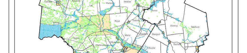

27 Map 3-1. Floodzones and Wetlands HOCTS 3-15 Chapter 3 Plan Requirements


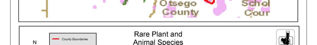
28 Map 3-2. Rare Plant and Animal Species HOCTS 3-16 Chapter 3 Plan Requirements
29 Map 3-3. Remediation Sites HOCTS 3-17 Chapter 3 Plan Requirements


30 Map 3-4. National Historic Registry Sites HOCTS 3-18 Chapter 3 Plan Requirements

31 Map 3-5. New York State Parks and State-Designated Historic Sites HOCTS 3-19 Chapter 3 Plan Requirements


32 Map 3-6. NYSDEC Managed Lands HOCTS 3-20 Chapter 3 Plan Requirements


33 Map 3-7. Agricultural Districts HOCTS 3-21 Chapter 3 Plan Requirements
34 Chapter 4 Demographics To effectively plan for future transportation needs, it is necessary to be responsive to regional demographic forecasts. Recent trends that affect transportation include: increased vehicles and trips, decrease in population, fewer households, longer commutes, and increased vehicle miles traveled. Transportation planning needs to consider emerging trends that will affect the future transportation system in the HOCTS study area. These emerging trends include lifestyle changes, deteriorating infrastructure, less funding available, an aging population, rising fuel costs, and concern for climate change. This chapter presents a snapshot of the study area in terms of current population, employment, primary commuting travel patterns, and land use patterns. POPULATION TRENDS Based on the 2000 U.S. Census, the population of Oneida County was 235,469. This represents a decrease of 15,367 or a 6.1% decrease from Oneida County registered the second largest net population loss within New York State between 1990 and The closing of Griffiss AFB and manufacturing firms are assumed to be partly responsible for the population loss. Herkimer County, also experienced a population decrease of 65,809 or a 2.1% decrease from 1990, based on the 2000 U.S. Census. The average population change for both Herkimer and Oneida Counties over a twentyyear period (1980 to 2000) was 4.1%. See Figure 4-1. Figure 4-1. Population Change in Herkimer and Oneida Counties, Oneida County Herkimer County Two-County Year Population %Change Population %Change Population %Change , % 64, % 299, % , % 65, % 316, % , % 66, % 320, % ,070 67, ,477 Source: 2000 U.S. Census Based on 2000 U.S. Census data, the population of three towns in Oneida County increased by 15% or more from 1990 to The Town of Florence grew by 27.5%. That is the largest town increase in Oneida County, followed by the Town of Remsen, which grew by 12.6%. During that same time period, the City of Sherrill s population grew by 9.9%. The Cities of Utica and Rome both had a significant loss in population 11.6% and 21.2%, respectively. In Herkimer County, two towns had a population growth greater than 15% from 1990 to The towns of Webb and Fairfield had the largest population increases, 16.8% and 20.9%, respectively. 1 The Village of Cold Brook, the only Village in the County that experienced population growth, grew by 8.4%. 1 Town of Fairfield population growth excludes Village of Middleville population change (-11.9%) HOCTS 4-1 Chapter 4 Demographics


35 Map 4-1. Population Shift, HOCTS 4-2 Chapter 4 Demographics
36 According to the 2000 Census, 7,921 (12.5%) of the Herkimer County population and 28,764 (13.0%) of the Oneida County population was living below the poverty level. Overall, the twocounty region had 36,685 (12.2%) people living below the poverty level. Other populations relevant to the transportation demographic profile are the elderly, people with disabilities, and households without vehicles. According to the 2000 Census, the elderly constitutes 16.5% (38,753) of the total Oneida County population; the people with disabilities make up 19% (44,106); and the households without vehicles make up 12.3% (11,130). Of the total Herkimer County population, the elderly make up 16.8% (10,844), people with disabilities make up 18% (11,689), and households without vehicles make up 10.1% (2,691). See Figure 4-2. Figure 4-2. Population Demographics for the HOCTS Planning Area TOTAL Data Set* Oneida County Herkimer County Two-County Area Total Population 235,469 64, ,896 Total Households 90,496 25, ,230 Minority Population 23,055 1,396 24,451 % of Total Population 9.8% 2.2% 8.2% People in Poverty** 28,764 7,921 36,685 % of Total Population 13.0% 12.5% 12.2% Elderly Population (65 yrs.+) 38,753 10,844 49,597 % of Total Population 16.5% 16.8% 16.5% Persons with Disabilities 44,106 11,689 55,795 % of Total Population 19% 18% 18.6% Households without Vehicles 11,130 2,691 13,721 % of Total Population 12.3% 10.1% 4.6% *Source: 2000 U.S. Census **Based on Poverty Thresholds for 2002 issued by U.S. Census Bureau Population Diversity According to the 2000 Census, 23,055 people in Oneida County and 1,396 people in Herkimer County were classified as non-white minorities. Although not reflected in the 2000 Census minority numbers, the Mohawk Valley has had a rise in the number of new minority population groups. The City of Utica has experienced over a 72.5% increase in refugee populations in the past ten years. Refugees, primarily within the City of Utica, are initially dependent on social services. The cultural differences and language barriers of the growing refugee population can make it difficult to secure employment. In the last ten years, nearly 7,474 refugees have been relocated to Utica and the Mohawk Valley. HOCTS 4-3 Chapter 4 Demographics
37 Refugee Population Utica is the home of the Mohawk Valley Resource Center for Refugees (MVRCR), one of the largest resettlement agencies in the Lutheran Immigration and Refugee Service network. According to the Mohawk Valley Resource Center for Refugees, Utica is one of few selected cities in the U. S. accepting refugees. Due to its cultural diversity, affordable housing and generous spirit, the community provides a foundation where these new Americans can find safety, freedom and the opportunity for a better life. MVRCR boasts that Oneida County has the fourth highest concentration of refugees (about 4% of the total population) in the United States, and the City of Utica refugees make up over 11% of the total population. MVRCR recognizes that the region is poised to become a leader as a multi-cultural institute and remains a nationally recognized leader in refugee services. Since its inception, MVRCR has assisted refugees from more than 31 countries, including Bosnia, Cambodia, Czechoslovakia, Haiti, Hungary, Laos, Poland, Romania, the former Soviet Union, Vietnam, Sudan, Somalia, Afghanistan, Iraq, Iran, China, Burma and others. Today the refugee population being resettled is increasingly diverse with individuals and families from the former Soviet Union, Afghanistan, Burma, Somalia and Liberia. Utica s growing immigrant community includes many from Latin America. Limited English Proficiency (LEP) According to the Civil Rights Office at the U.S. Department of Transportation, individuals who do not speak English as their primary language and who have a limited ability to read, speak, write, or understand English can be Limited English Proficient, or LEP. These individuals may be entitled language assistance with respect to a particular type of service, benefit, or encounter. The enactment of Executive Order 13166: Improving Access to Services for Persons With Limited English Proficiency (LEP) August 16, 2000, was to clarify Title VI of the Civil Rights Act of 1964 by ensuring accessibility to all federally conducted programs and activities to individuals whom English is not their primary language and who might have a limited ability to read, speak, write or understand English. Executive Order applies to all federal agencies and all programs and all operations of entities that receive funding from the federal government, including state agencies, local agencies and governments including the MPO, private and non-profit entities and subrecipients. Local LEP Efforts The Mohawk Valley Resource Center for Refugee (MVRCR) in Utica, NY is actively working to fulfill new strategic directions for the center reflecting the presence and needs of the growing refugee and non-refugee immigrants in our community, estimated future growth to be approximately 15% of Utica s population. MVRCR is focused on enabling individuals and communities to promote and sustain their cultural identity. The center is collaborating with the Mohawk Valley Latino Association (MVLA) and the African Alliance as they work to solidify their organizations within the community. MVRCR offers these groups and others an opportunity to share facilities and services that will provide the necessary tools to build long-term relationships in their respective ethnic communities and in the Utica community. HOCTS 4-4 Chapter 4 Demographics
38 MVRCR is also striving to increase access to medical assistance to Limited English Proficiency individuals within the community. MVRCR recently completed contractual agreements with Faxton-St. Luke s Healthcare and St. Elizabeth Medical Center to provide interpretationtranslation services that will enhance the support system for Utica s growing immigrant population. These services provide Limited English Proficiency (LEP) patients critical access to medical services. Currently, the center is able to provide interpretation-translation services in eight (8) languages, including Bosnian/Serbo Croatian, Russian, Arabic, Persian/Dari, Burmese, Vietnamese, Maay, Kiswahili and Spanish. MVRCR is actively recruiting potential interpreters in these and other languages, who will be professionally trained to provide quality interpretation. MVRCR seeks to enhance the provision of culturally and linguistically appropriate services in the community. The center s objective is to provide fee-based cross-cultural competence training and technical assistance. The program is designed to help educators, service providers and business managers, effectively deliver service to clients and manage personnel from different cultural backgrounds. HOCTS has worked with MVRCR to address the needs of refugee populations through the use of JARC funds. Limited English Proficiency (LEP) Statistics The NYSDOT Region 2, which includes Oneida and Herkimer Counties, has 13,540 LEP residents (3%), giving it the 8th most LEP residents of the 11 NYSDOT regions. 2 Figures 4-3 and 4-4 show two counties in Region 2 having significant LEP populations: Montgomery and Oneida (4% of the total population); Herkimer and Madison Counties also have noteable LEP population. Of the 62 counties in New York State, Oneida County has the 16 th highest LEP population. In Montgomery and Oneida Counties, almost 70 percent of the LEP population lives in the largest city. Utica maintains 6,101 (11%) LEP population. Outside of New York City, Utica has the 8 th largest LEP population of any city in New York State. Map 4-2 shows the LEP populations in Herkimer and Oneida Counties and Map 4-3 shows LEP population concentrations in Oneida County. Utica s LEP population mostly comes from the European nation of Bosnia (3,319), where an Indo-European language is spoken. A wave of Bosnians immigrated to Utica between 1992 and Currently, refugees from the Asian nation of Burma (560) are moving to Utica. According to data provided by the NYS Office of Temporary and Disability Assistance, other common refugee groups in Utica are Ukrainian (453), Vietnamese (412) and Belarusian (361). Figure 4-3. LEP Population, NYSDOT Region 2 by County COUNTY Spanish Indo-European Asian-Pacific All Others Total Fulton Hamilton Herkimer Madison Montgomery 1, ,859 Oneida 2,178 5,374 1, ,968 Total 4,497 7,824 1, ,289 Source: NYSDOT 2 NYSDOT Region 2 consists of Herkimer, Oneida, Madison, Hamilton, Fulton and Montgomery Counties HOCTS 4-5 Chapter 4 Demographics


39 Figure 4-4. LEP Population, NYSDOT Region 2 by City CITY Spanish Indo-European Asian-Pacific All Others Total Amsterdam ,283 Gloversville Johnstown Little Falls Oneida Rome Sherrill Utica 1,098 3, ,101 Source: NYSDOT Map 4-2. New York State LEP Population by County Source: NYSDOT HOCTS 4-6 Chapter 4 Demographics


40 Map 4-3. LEP Populations in Oneida County Source: NYSDOT, Oneida County GIS HOCTS 4-7 Chapter 4 Demographics
41 Population Forecasting Based on population projections provided by the Cornell Institute for Social and Economic Research, Oneida County may see a slight decrease in its population over the projected 20-year period. Likewise, the overall population for Herkimer County is projected to decrease slightly; see Figure 4-5 below. Figure 4-5. Population Projections, County 2000 Actual 2010 Estimate 2015 Estimate 2020 Estimate Oneida Herkimer 235,469 64, ,761 61, ,884 59, ,681 58, Estimate 229,671 55,831 Source: Cornell Institute for Social and Economic Research, 2003 TRAVEL TRENDS In March of 2000, a Statewide Attitudinal and Preference Survey funded by New York State Metropolitan Planning Organizations, was part of a statewide initiative to attain public input for transportation planning purposes. The surveyed region of Central New York was comprised of ten counties: Oneida, Herkimer, Madison, Wayne, Seneca, Cayuga, Tompkins, Oswego, Onondaga, and Cortland. According to the survey, in the Central New York region 86.4% of the respondents surveyed commute on a daily basis. The primary reason for their commute is to get to work and the household vehicle is the clear mode choice. Respondents who commute by car commented that convenience and lack of alternative transportation options are the major reasons for using their car instead of public transportation. However, out of the 300 Central New York residents surveyed, 240 or 80% indicated that carpooling would be an option if there were more Park and Ride locations in their area. Travel Characteristics The Census Transportation Planning Package (CTPP 2000) profiled and compared travel characteristics for 1990 and Figure 4-6 below illustrates those characteristics for Herkimer and Oneida Counties. Figure 4-6. Mode Split, 1990 to 2000 HERKIMER CHANGE 1990 to 2000 ONEIDA CHANGE 1990 to 2000 Characteristic % % Characteristic % % Drove Alone Drove Alone Carpooled Carpooled Public Transportation Public Transportation Bicycled or Walked Bicycled or Walked Work at Home Worked at Home Source: U.S. Census Bureau The ten-year comparison revealed an increase in people driving alone to work and there was a slight reduction in the occurrence of commuters carpooling to work. However, the use of public transportation increased in Herkimer County while in Oneida County it decreased. The existing HOCTS 4-8 Chapter 4 Demographics
42 transit in the HOCTS planning area is primarily the Utica, Rome, parts of Oneida County, Little Falls, and the Mohawk Valley corridor. Travel Time to Work Average travel time to work, for workers in the Utica-Rome Metropolitan Area, increased slightly between the 1990 and 2000 Censuses, as illustrated in Figures 4-7 and 4-8. The two longer categories ( Minutes and Greater than 45 minutes ) show a combined increase of 5%, possibly indicating that there are more workers using the transportation system for a longer duration daily. It is difficult to conclusively determine from this statistic alone whether the slight increase in travel time is due to congestion or population shift. But based on analysis of the population shift portrayed in Map 4-1 and the vehicle miles traveled (VMT) data shown in Figure 4-9, it is reasonable to presume this increase is more likely attributable to population shift than increased traffic congestion. Figure 4-7. Travel Time to Work, 1990 Travel Time to Work, % 31% 63% Less Than 20 Minutes Minutes Greater Than 45 Minutes Figure 4-8. Travel Time to Work, 2000 Travel Time to Work, % 33% 58% Less Than 20 Minutes Minutes Greater Than 45 Minutes HOCTS 4-9 Chapter 4 Demographics
43 Vehicle Miles Traveled According to the Federal Highway Association (FHWA), there was a 23% increase in Vehicle Miles Traveled (VMT) in the Herkimer-Oneida Counties Urbanized Area from 1990 to 2000, as illustrated in Figure 4-9 below. While VMT increased, population in the Urbanized Area decreased by 7%. Although population has declined, factors such as multiple-vehicle households, more trips per household, increase in the number of eligible drivers per household, and living further away from work all contribute to the increase in VMT. Figure 4-9. Vehicle Miles Traveled (VMT) and Population Change, % 20% % Change 15% 10% Popl. Change % VMT Change % 0% -5% -7% 1-10% Regional Labor Market Travel Patterns The majority of workers in both Herkimer and Oneida Counties work in their County of residence 3 59% and 88% of workers age 16 or older, respectively. In addition to the statistics shown in Figure 4-10, there are 4,579 non-residents who work in Herkimer County and 19,230 non-residents who 4 work in Oneida County. Figure Employment-Related Travel Patterns Herkimer County Workers Age 16 or Older 28,622 Work in County of Residence (%) 16,760 (59%) Work Outside County of Residence (%) 11,862 (41%) Oneida County 100,800 89,035 (88%) 11,765 (12%) Source: U.S. Census Bureau, Employment In June 1993, the Base Realignment and Closure Commission (BRAC) voted to realign Griffiss Air Force Base effective September 30, With the realignment completed, Griffiss Air Force Base ceased to operate and was renamed The Griffiss Business and Technology Park. 3 4 U.S. Census U.S. Census Bureau Community Transportation Planning Package, HOCTS 4-10 Chapter 4 Demographics
44 Redevelopment at Griffiss Business & Technology Park has attracted a wide variety of tenants. The business park has been successful in attracting public and private investment from the research, banking, technology, transportation, education, medical, technical, distribution, telecommunications, manufacturing, law enforcement and hotel industries. The U.S. Air Force maintains a presence at Griffiss and remains as a major tenant in the business park. Today, few vacant buildings remain at Griffiss, meaning future development and most recent development will be private sector construction of new buildings. In 2005, Family Dollar invested $64 million in a new distribution center, a local credit union spent $7 million to build a new office and branch, a local human services agency invested $7 million in a new campus, a local dentist built a new building, and a local ophthalmologist-turned-developer constructed a third office building for lease. In 2007, one of North America s largest olive oil distributor moved into a new plant, a local bank opened a new office, the human services agency expanded and the ophthalmologist-turned-developer constructed a fifth office building, bringing total employment at Griffiss Business & Technology Park to over 5,000. The City of Rome School District also has constructed a new high school Rome Free Academy on the Griffiss campus. Overall, the Mohawk Valley continues to move forward by focusing on its assets and meeting its challenges. The Mohawk Valley has strengths and growth potential in several industrial clusters, among them are: Aviation - Empire Aero Center, a subsidiary of Israel Aerospace Industries, operates a maintenance, repair and overhaul facility in a refurbished former Air Force hangar. In 2006, Mohawk Valley Community College opened an airframe and power plant mechanic training program next door to Empire Aero Center's facility, to train the next generation of aviation personnel. Within sight of the Empire Aero Center hangar, manufacturer Goodrich Power Transmission Systems is the world's leading supplier of high technology drive systems for helicopters, fighter/bomber aircraft and tiltrotor aircraft Logistics - In 2006 Family Dollar opened the third major retail distribution center in the Mohawk Valley, joining Rite Aid and Wal-Mart as national chains that have realized the logistical value of the Mohawk Valley. Metals Manufacturing - This cluster has a strong regional history dating to the early 1800s. From the founding of Remington Arms and Revere Copper Products almost two centuries ago to the advanced metallurgy found today at Special Metals Corporation, HMI Metal Powders (a United Technologies Company) and others, the Mohawk Valley has been at the forefront of this industry. International Wire, Owl Wire (owned by the Marmon Group), and TECT all have major manufacturing operations in the Mohawk Valley. Finance, Insurance and Real Estate - The Mohawk Valley has become a center of major back office operations including insurance claims, check processing and call centers. Bank of America, The Federal Reserve, Bank of New York, Metropolitan Life, The Hartford, Defense Finance and Accounting Service and ACS all have major centers in the Mohawk Valley, and Utica National Insurance Company's international headquarters are here. IT and Information Assurance - Led by the Air Force Research Laboratory Information Directorate headquarters, the Mohawk Valley has developed a significant niche in the IT HOCTS 4-11 Chapter 4 Demographics
45 industry over the last half century. Today, international firms such as PAR Technology, BAE Systems, Booz Allen Hamilton, ITT Industries and Northrop Grumman have offices in the region, and homegrown companies such as Dolphin Technology, Black River Systems, Assured Information Security, New York State Technology Enterprise Corporation, Syracuse Research Corporation and Research Associates of Syracuse are becoming forces in the industry. Occupational Projections According to the New York State Department of Labor s Occupational Projections , employment for the Mohawk Valley Region for all occupations for the ten-year period is projected to increase from 221,410 to 230,530, a 4.1% change. Listed below are the occupations projected to have the most openings from Please note that total openings include not only openings due to growth, but also openings due to separations, the need to replace people exiting the occupation. Figure Employment Projections in the Mohawk Valley, Title Cashiers Retail Salespersons Waiters and Waitresses Registered Nurses Home Health Aides Customer Service Representatives Laborers and Freight, Stock, and Material Movers, Hand Food Preparation Workers Janitors and Cleaners, Except Maids and Housekeeping Cleaners Source: New York State Department of Labor Annual Average Openings Employment ,110 5,690 6,390 6,900 3,030 3,110 4,810 5,550 3,720 4,800 3,160 3,610 3,290 3,340 2,550 2,760 4,070 4,350 Listed below are the 10 fastest growing occupations in the Mohawk Valley. Please note that some of these occupations, although growing fast, have relatively small employment levels. Figure Growth Occupations in the Mohawk Valley, Percent Change Title Personal and Home Care Aids Home Health Aides Network Systems and Data Communication Analysts Dental Hygienists Physical Therapist Aides Medical Assistants Computer Software Engineers, Applications Mental Health and Substance Abuse Social Workers Physician Assistants Dental Assistants Source: New York State Department of Labor HOCTS 4-12 Employment ,700 2,350 3,720 4, Chapter 4 Demographics
46 Welfare-To-Work The region s welfare to work effort has been successful in dealing with many adults, leaving those still needing services the hardest to serve due to barriers to employment that include ex-offender status, disability status and refugee status. Health services remain the major employment sector that can hire and place new workers, but for those with the barriers mentioned above, entry level jobs are difficult to obtain. Geographically, job growth remains concentrated outside of the core cities where the most people live, however there have been efforts on the part of CENTRO to address this by adding routes to suburban areas, such as shopping malls, that are also major entry-level employers. Addressing these barriers has resulted in a number of partnerships between the Workforce Investment Board and Social Services to develop programs that focus on the populations with the greatest needs. For example, the Wheels to Work program, which involves the WIB, DSS and Resource Center for Independent Living, can help individuals who need private transportation to get to and from work meet the cost of a down payment on a car and arrange the financing. Because many potential job seekers come with skills deficits, the WIB and DSS are partners in a Wage Subsidy program that offers a small number of cases a wage subsidy for a period of time, which makes it much easier for an employer to take a chance on a welfare-to-work customer. A mix of training and supports is offered to young adults with disabilities between the ages of 16 and 25 through the WIB s CareerStart program, funded by a federal grant. By increasing the numbers of young adults with disabilities attached to the workforce, this project can help young adults who are able to be self-supporting. One of the most interesting chapters of the regional welfare-to-work effort began in the summer of 2009 as the WIB and a coalition of more than 30 partners began implementation of the Career Pathways project, a regional effort that covers six counties including Herkimer and Oneida. The program seeks to provide entry-level training and jobs for individuals with barriers to employment and is designed to also provide training that will allow clients to enter employment with the skills they need to handle not just their first job, but the next as well. Empire Zones The New York State Empire Zones (EZ) Program, formerly known as the New York State Economic Development Program, was created in 1986 to stimulate economic growth through a variety of financial incentives designed to attract new businesses and to enable existing businesses to expand and create new jobs. As a result of the regional economic development strategy devised by area officials in 1997, Mohawk Valley EDGE (EDGE) has coordinated the economic development efforts for Oneida County. EDGE has been designated by the County of Oneida and the City of Rome to administer both the Oneida County and City of Rome Empire Zone programs. See Empire Zone Maps 4-2 and 4-3 The City of Rome Empire Zone identified those areas with current zone businesses with potential for expansion, areas with the highest potential for future growth and to address the blighted condition of the central business district. The three areas identified by the City of Rome Zone are HOCTS 4-13 Chapter 4 Demographics
47 the West Rome Industrial Park, Griffiss Business & Technology Park which are desirable for future growth and the City of Rome Central Business District which will address Rome s Downtown Urban blight through the revitalization of three targeted downtown corridors. In the Rome Zone there are 109 certified businesses that employ approximately 3,150 employees. The five largest employers are Revere Cooper Products, Rite Aid Distribution Center, Empire Aero Center, Goodrich Corporation and Cathedral Corporation. In the re-designation of the Oneida County Empire Zone the Zone identified areas in Oneida County with existing zone businesses with potential for expansion, areas with the highest potential for future development, and areas where there has been significant job loss. The seven areas identified by the Oneida County Empire Zone are Judd Road, Town of Whitestown; Griffiss Business & Technology Park (Family Dollar site); Oneida County Airport Business Park; Town of New Hartford (New Hartford Business Park, Woods Road, and Middle Settlement Road); Village of New York Mills; Sherrill (Oneida Ltd. former manufacturing plant and warehouse); and Boonville (former Ethan Allen furniture manufacturer s site. In addition to the seven identified zone areas two additional sites have been approved as Regionally Significant projects giving them Empire Zone designation. There are currently 106 certified businesses in the Oneida County Zone employing 8,660 employees. The five largest certified businesses located within the designated zone areas are: The Bank of New York, Special Metals, Daimler Commercial Buses North America, The Hartford and Family Dollar Distribution Center. In 2005, Herkimer County had 52 Empire Zone certified businesses employing 3,231 full time employees. The Herkimer County Industrial Development Agency coordinates the Empire Zone in Herkimer County. There are seven designated Empire Zones in Herkimer County located in the following areas, 1) Little Falls Industrial Park area, 2) East Herkimer (former Herkimer Distribution site and the Lowe s Home Improvement Center site), 3) West Herkimer (near the County Garage combined with an area along Route 5S in Mohawk), 4) Village/Town of Frankfort (5 South and 5S North Business Parks), 5) Town of Frankfort (West Frankfort Industrial Park area), 6) Town of Schuyler (Schuyler Business Park area), and 7) Village of Ilion (Remington Arms and former Duofold plant area). There are also numerous businesses that are certified that were grandfathered into the program after re-designation of the zone was done in Also, Erie Educational Services in the Village of Frankfort is a certified business that was included after being designated a Regionally Significant Project. HOCTS 4-14 Chapter 4 Demographics


48 Map 4-4. Empire Zone Sites in Oneida County HOCTS 4-15 Chapter 4 Demographics
49 Map 4-5. Empire Zone Sites in Herkimer County HOCTS 4-16 Chapter 4 Demographics
50 Land Use General Land Use Patterns Land use in the Herkimer-Oneida Counties area consists of immense areas of forest, agriculture and other undeveloped land. Developed land consists of relatively small urban/village centers that have sprawling suburban residential development. Urbanized land uses in Herkimer County are primarily located within a few miles of the NYS Thruway, Erie Canal, and NYS Routes 5 and 5S. In Oneida County, suburban residential and commercial development extends outward from the City of Utica, to the south and west along highway corridors, including the towns of New Hartford, Whitestown and Kirkland. Residential and commercial development continues in the Town of Verona due to the expansion of the Turning Stone Casino, an increasingly popular tourist destination. There is a mix of residential densities and housing types within the cities and villages of Herkimer and Oneida Counties. Single-family housing is the dominant type of residential use. However, two-family and, to a lesser extent, multi-family housing is more common in the Utica urbanized area. Low-density housing and sub-divisions are located in outlying areas. Individuals residing in outlying rural developments may generate higher levels of Vehicle Miles Traveled (VMT) than individuals who reside in an urbanized setting. New Housing Units in Oneida and Herkimer Counties New Housing Starts information provided by the 2000 U.S. Census provides an indication of growth or migration patterns within a certain geographic area. In Oneida County, the towns with over 200 new (built since 1980) housing starts included: Vienna Verona New Hartford Whitestown Westmoreland Outer portion of the City of Rome Herkimer County towns with over 200 new (built since 1980) housing starts included: Ohio Webb Danube Little Falls Winfield Also, in Oneida and Herkimer Counties, there were 22 towns that had new housing starts ranging from 100 to 199. Sprawl in Upstate New York An October 2003 study by the Brookings Institution entitled "Sprawl Without Growth: The Upstate Paradox," analyzes growth and development trends and population in Upstate New York. This study points out the between "1982 and 1997 upstate New York converted over HOCTS 4-17 Chapter 4 Demographics
51 425,000 acres of land from rural uses to urban development" while the population only grew by 2.6%. According to the same article, the Central New York region, which includes Syracuse, UticaRome and surrounding counties, urbanized over 100,000 acres between 1982 and 1997, a 45% increase, even though it lost 6,500 residents resulting in a 32 percent decrease in its density. As a result of this upstate sprawl, people have been leaving cities and villages and moving out to less urbanized areas. The "new" housing starts statistics noted above underscores this point in the Herkimer-Oneida Counties area. The article goes on to say that critical impacts of upstate sprawl is the decline in city tax bases and a dramatic decline in cities assessed value. As a result, cities bond for many of their infrastructure or economic development improvements, increasing municipal indebtedness and compounding the problems associated with a shrinking tax base. The study noted that if projects funded by the bonds fail to increase cities tax base, future taxpayers will be burdened with rate increase unless there is increased financial support from the State level. Findings from the study cite the disparity among the property tax rates of Upstate cities, villages, and towns to be the most important policy-related contributor to sprawl.5 The impact of sprawl on transportation infrastructure is becoming more apparent as populations migrate to more rural and suburban communities and put an increased demand on the local road system. Many towns are faced with people living in scattered, low-density areas without services and infrastructure found in more urbanized areas. Municipalities are authorized to undertake comprehensive planning through New York s General City, Town and Village Laws. Similar provisions exist in the General Municipal Law, which grants counties and regional planning councils the authority to develop county and regional comprehensive plans. Comprehensive planning, at both the municipal and regional levels, serves as an effective mechanism to identify and initiate sound planning principles. Chief among these principles is that such planning responds to a community s own sense of how and where it wants to grow. Consistent with the State s energy policy objectives, a chief benefit of sound planning is the potential efficiency gains derived from communities that plan around compact, mixed-use centers that do not rely on automobile trips for all day-to-day needs. Smart Growth integrates land use planning and transportation on both the local and regional level to create communities that use less energy; that is, compact, mixed-use, walkable, bikeable, transit-friendly communities that rely less on automobile travel. Future projects will be reviewed for implementation not only by utilizing the available land use data, but also in terms of what type of corridor (i.e. trade, commuter, tourism, intercity passenger, and general purpose, including multi-modal). These corridor types are included in NYSDOT s Strategies for a New Age: New York State s Transportation Master Plan for 2030 and may be used as the basis for all transportation planning and program development. Future planning efforts by NYSDOT may also include looking at projects on a more global scale, including new projects that could impact neighboring counties and states.6 5 Sprawl Without Growth: The Upstate Paradox. Brookings Institution, HOCTS 4-18 Chapter 4 Demographics
52 Transportation Modeling Transportation modeling involves both data collection and the use of software to analyze the data and output the results of the transportation model. The Long- Range Transportation Plan (LRTP) looks at both the current road network and its traffic volume to analyze traffic scenarios. Using this model for the LRTP can create future transportation scenarios for the two-county area. Transportation modeling is a very data dependent process and analysis. The data needed includes, but is not limited to, demographic data, land use information, traffic counts, and the road network to be modeled.. In using this data, the model is created for the transportation network in our two-county region. The model estimates where traffic is coming from and going to and what route the trip uses to get from the origin to the destination. Using current data and traffic counts the model is calibrated to accurately simulate known values on the road network. The same model parameters may or may not be used to look at future scenarios. Altering future land use and employment data is used to estimate future traffic scenarios. SUMMARY HOCTS, as the designated MPO for the two-county area, continues to effectively plan for the future transportation system in the two-county area by being responsive to future regional demographic forecasts and transportation needs. The information gathered in this chapter reflects the recent trends that affect the transportation planning in the region which include increased vehicles and trips, decrease in population, fewer households, longer commutes, and increased vehicle miles traveled. Emerging trends that will effect the region s future transportation system include lifestyle changes, deteriorating infrastructure, less funding available, an aging population, rising fuel costs, and concern for climate change. Public comments are always encouraged and are an important component for future transportation planning for the region. The public input and demographic data provide the framework for the LRTP for ensuring a responsive and comprehensive transportation system for the communities of the planning area. HOCTS 4-19 Chapter 4 Demographics
53 Findings and Recommendations Findings: Although the two-county population continues to decline, it is slowed by the increase in the refugee population. Population continues to shift from urbanized areas to rural and outlying suburban communities The number of vehicles per households has increased More people are driving alone and have longer commutes Vehicle miles traveled (VMT) has increased Disabled, low-income, and the elderly constitute a significant portion of the population Fastest growing occupations for the next 10 years include the fields of Technology, Health Care, and Social Services Local and regional land use plans should be updated on a regular basis Recommendations: Encourage "Smart Growth" land use policies and urban revitalization efforts Encourage alternate modes of transportation such as biking, walking, and use of public transit Support Welfare-to-Work and ride share transportation programs Continue efforts of the Transportation Coordination Committee for the coordination of human service transportation planning in the two-county area for the low-income, disabled, elderly and refugee populations Research transportation needs of regional employers Support updating local and regional land use plans HOCTS 4-20 Chapter 4 Demographics
54 Chapter 5 Transit The Central New York Regional Transit Authority s (CNYRTA) subsidiary, Centro of Oneida, is the public transit operator which serves the Utica Urbanized Area and the Non-Urbanized Area of the City of Rome. The rural area of Oneida County, including the Mohawk Valley Corridor, is served by a private operator, Birnie Bus Service, Inc.; see Map 5-1. Public Transit In January 2004, the public transit services previously provided by the Utica-Rome Bus Company, Inc (Coach USA) and Oneida County Rural Transit changed operator. In an expanded agreement with Oneida County, Birnie Bus Service, inc. expanded service in its line haul operation in the Mohawk Valley Corridor, took over the public transportation service from the Utica-Rome Bus Company and became the operator of the expanded Oneida County Rural Transit services, previously operated by the Oneida County Office for the Aging. The rural service provides public transit to passengers who need service from and to the non-urbanized area. On April 1, 2005, Oneida County joined Central New York Regional Transportation Authority (CNYRTA), which assumed all operations of the Utica Transit Authority (UTA). The State of New York provided $2.7 million in capital assistance to immediately rehabilitate the fleet and facility. On October 1, 2005, CNYRTA assumed the operations of the Rome VIP Transportation, which provided transit services for the City of Rome. The following is a description of the current public transit services in Oneida and Herkimer Counties: 1. Centro of Oneida Utica - Centro of Oneida Utica operates fixed route and demand-response services throughout the City of Utica and in portions of the Towns of New Hartford, Whitestown and Kirkland. The fixed route system consists of 7 routes that are based at the downtown Utica transfer center located at Genesee and Bleecker Streets. Complementary Paratransit service is provided. Centro Call-A-Bus Paratransit provides ride services to individuals with disabilities who are unable to use the Centro Transit Bus and who meet the criteria established by the Americans with Disabilities Act (ADA) of Both services are based at the Centro maintenance and operations facility located at 185 Leland Avenue in Utica. 2. Centro of Oneida Rome - The Centro of Oneida Rome operates fixed route and demand response services within the City of Rome. The fixed route system consists of 6 routes that are based at the downtown Rome transfer center located at 225 Liberty Street; complementary Paratransit service is provided. Centro Call-A-Bus Paratransit provides ride services to individuals with disabilities who are unable to use the Centro Transit Bus and who meet the criteria established by the Americans with Disabilities Act (ADA) of The fixed-route and paratransit operations are also based at the downtown Rome transfer station. Centro's maintenance facility is located at the Race-Martin Street Station in Rome. HOCTS 5-1 Chapter 5 Transit

55 3. Birnie Bus Service, Inc. Birnie Bus Service, Inc. (BBS) is a privately owned company that provides interurban transportation in Central New York from Syracuse to Little Falls and rural public transportation in Oneida, Herkimer, Madison, and Onondaga Counties. The fares charged by BBS are on a zone-to-zone system in accordance with an approved tariff. BBS has its major office and garage facilities in Rome, New York. BBS is a major provider of human services transportation in Oneida County holding contracts with; Developmental Disabilities Services Office (DDSO), The ARC of Oneida-Lewis Chapter, Upstate Cerebral Palsy (UCP), Vocational & Educational Services for Individuals with Disabilities (VESID), Ava Dorfman Senior Center, YMCA, Loretto Utica Center and others. BBS operates a number of Section 5310 funded vehicles via operating lease with the grant recipient. Line Service BBS provides area residents with coach line service between Utica and Rome along Route 49, with route deviation onto Route 69; and provides interurban transportation in Central New York from Syracuse to Little Falls. Rural Service As of January 1 st 2004, BBS took over rural transportation service from the Oneida County Office for the Aging, providing public transit to passengers who need service to and from the urbanized area and within the non-urbanized area. The thirteen route deviation transportation services are provided Monday through Friday. The rural transportation service area includes Boonville, Utica, Camden, Remsen, Floyd, Chadwicks, Rome, Sauquoit, Taberg, Waterville, Bridgewater, Sauquoit, Vernon and Barneveld. HOCTS 5-2 Chapter 5 Transit


56 Map 5-1. Public Transit Routes HOCTS 5-3 Chapter 5 Transit
57 ADA Paratransit Under Title II of the Americans with Disabilities Act (ADA) of 1990, public transportation systems are required to provide services for people with disabilities when mobility limitations prevent them from using the transit bus. Such services are called demand-response as they typically are initiated by an individual request for service from the disabled customer. ADA regulations expressly define the types of service, the accessibility features required on all transit vehicles, the eligibility criteria and application processes, and parameters for scheduling rides. Centro of Oneida Call-A-Bus - Utica The Utica Call-A-Bus service meets the Federal Transit Administration (FTA) service criteria. There are up to 6 buses in use on weekdays and 2 buses operating on Saturday. The regular bus route service does not operate on Sunday; therefore Call-A-Bus is not required under the ADA. The Utica Call-A-Bus offers curb-to-curb service. The ridership is between 90 and 115 per weekday and approximately 30 riders on Saturdays. Centro of Oneida Call-A-Bus - Rome There are up to 2 call-a-buses in use on the weekdays and 1 bus operating on Saturday. The fixed route service does not operate on Sunday; therefore Call-A-Bus is not required under the ADA. The Rome Call-A-Bus offers curb-to-curb service. The customer base is mostly seniors with limited mobility. Transit Consolidation and Coordination The Safe, Affordable, Flexible, and Efficient Transportation Equity Act: A Legacy for Users (SAFETEA-LU) requires a locally-developed, coordinated public transit-human services transportation plan for all FTA-funded human services transportation programs. It also requires the plan to be developed by a process that includes representatives of public, private, and nonprofit transportation and human services providers and public participation. SAFETEA-LU increases coordination requirements by requiring that, per planning requirements beginning in FFY2007, projects must be selected based on a locally-developed human-service transportation coordination plan. The purpose of the HOCTS Coordinated Human Services Transportation Plan (HSTP) is to comply with federal and state requirements, and to focus on the coordination of transportation services funded under three federal grant programs; Job Access and Reverse Commute (JARC, Section 5316), Elderly and Individuals with Disabilities (Section 5310), and a new program called New Freedom (Section 5317). The HSTP will be used as the basis for selecting transportation projects under the three federal grant programs. Although the locally-developed HSTP covers the HOCTS Planning Area, the federal funding available through JARC and New Freedom must be used for service within the Utica Urbanized Area. Funding under JARC and New Freedom for Non-Urbanized Areas is available through NYSDOT. The State also uses the HSTP in selecting projects for the nonurbanized areas of Oneida and Herkimer Counties. The three federal grant programs are: HOCTS 5-4 Chapter 5 Transit
58 1. The Section Elderly and Individuals with Disabilities Program is an annual, formula-based program that provides federal funding to States for the purpose of assisting private nonprofit groups in meeting the transportation needs of the elderly and persons with disabilities when transportation service to meet these needs is unavailable, insufficient, or inappropriate. According to the Section 5310 State Management Plan in New York State, the funding can only be used for the purchase of vehicles. 2. The Section Job Access and Reverse Commute (JARC) Program is a competitive process, formula-based program to develop transportation services designed to transport welfare recipients and low-income individuals to and from jobs (Job Access), and to develop transportation services for residents of urban centers and rural and suburban area to suburban employment opportunities (Reverse Commute). Emphasis is placed on projects that use public transportation services. 3. The Section New Freedom Program is a formula-based grant program to encourage services and facility improvements to address the transportation needs of persons with disabilities that go beyond those required by the Americans with Disabilities Act of Program funds can be used for associated capital and operating costs to programs that provide new public services and alternatives beyond the requirements of ADA that assist individuals with disabilities. Human Services The two-county region has a number of human service transportation providers that offer services designed to aid primarily elderly and disabled customers, but they are not mandated services under the ADA. The HOCTS Transportation Coordination Committee (TCC) consists of these transportation providers in addition to human service agencies including, but not limited to: The ARC, Oneida-Lewis Chapter NYSARC; Central Association for the Blind & Visually Impaired; Faxton Sunset St.Luke s Health Care Center; Herkimer Area Resource Center; Herkimer County HealthNet, Inc.; Human Technologies Corporation; Kids Oneida, Inc.; Mohawk Homestead; Mohawk Valley Nursing Home, Inc.; Mohawk Valley Resource Center for Refugees; Presbyterian Home; Rescue Mission; Resource Center for Independent Living; Retired Senior Volunteer Program at Catholic Charities; Rome Hospital Foundation; St. Joseph s Nursing Home; Valley Health Services, Inc.; and Vocational & Educational Services for Individuals with Disabilities (VESID). Welfare-to-Work Oneida County, acting as the applicant for Herkimer and Oneida Counties, has been successful in acquiring the award of four separate grants that provided services for opportunities to lowincome individuals to be gainfully employed and helped supply workers for area employers at a relatively low delivery cost. The goal of these grants has been to develop an integrated transportation system that makes it possible for those on welfare to get to where the jobs are located. Without such a system, which requires a healthy public transit system, workforce needs cannot be met in an affordable way. These programs, through the Welfare-to-Work grants, assist and benefit the target population of this study. The first grant was from the State of New York under Temporary Assistance to Needy Families (TANF) in 2001 for $575,353. Under a replacement program for TANF, known as Community HOCTS 5-5 Chapter 5 Transit
59 Solutions to Transportation (CST), Oneida County received subsequent grant awards over the following eight years totaled in excess of $1.4 million dollars. In addition, Oneida County received grant awards from FTA under the JARC program totaling about $448,000. Projects under these grants, included Transit Tokens, Guaranteed Ride, Driver Readiness, Auto Insurance, Vehicle Repair, Gas Card, Travel Training, LaSalle Labs Shuttle Service, and a Mobility Management Function. Under the Mobility Management Function, a Mobility Center was established. A Transit Information Specialist and a Call Taker/Dispatcher staff the Mobility Center, which provides scheduling, dispatching, reporting, billing, and other mobility functions. In conjunction with the Oneida County award of CST grants, CENTRO of Oneida was also awarded grants from the NYS Community Solutions for Transportation (CST) funding, the first for SFY 2007 and the second for SFY Each grant of $100,000 funded transit route enhancements and transit passes for TANF eligible employees. The transit route enhancements increased service hours to the Griffiss Business and Technology Park in Rome, NY and provided night bus service on two routes serving Consumer Square. Both locations were targeted for additional bus service to address employment growth. Transit passes are distributed from Centro hub locations in Utica and Rome based on referrals from DSS. In February 2008, a Wheels for Work III Request for Proposal, submitted by the Workforce Investment Board of Herkimer, Madison, Oneida Counties (WIB) for $174,500, was selected for funding, a Drive for Success program. Drive for Success is a regional program that assists individuals with disabilities acquire vehicles. The Workforce Investment Board (WIB) plans to partner with The Resource Center for Independent Living (RCIL) to assist in the purchase and repair of automobiles for eligible clients who need a vehicle to maintain employment. Transit Capital Area transit operators receive Federal Transit Administration (FTA) grants to subsidize capital and operational expenses. The FTA grants provide 80% of the cost of capital equipment and projects. State and local matching funds provide the additional 20%. Figures 5-1 and 5-2 summarize the estimated 20-year capital and operating needs and estimated revenue that will be needed to insure that buses, facilities, and equipment are replaced and maintained in a state of good repair according to FTA and other widely accepted useful life standards for such capital items. HOCTS 5-6 Chapter 5 Transit
60 Figure 5-1. Estimated 20-Year Transit Capital & Operating Needs Transit Operator Projected Capital Projects Total Cost Estimates Centro of Oneida 52 replacement buses-utica $19,500, replacement buses-rome $4,500,000 Centro of Oneida 27 Paratransit vehicles-utica $2,565,000 8 Paratransit vehicles-rome $760,000 Centro of Oneida New transit garage $15,000,000 Birnie Bus Tours 8 Fixed Route intercity $3,608,000 2 Fixed Route Rural $280, Rural Route $3,945,000 4 Other Vehicles $140,000 Union Station- Utica Capital Improvements $3,000,000 Total Capital Source: TIP, Centro of Oneida and Birnie Bus Service, inc. $53,298,000 Transit Operator Projected Operating Total Cost Estimates Centro of Oneida 5307 Operating Assistance $64,420, Operating Assistance $12,600,000 Birnie Bus Tours 5307 Operating Assistance $12,800,000 Total Operating Capital Operating 5311 Operating Assistance $3,756,000 $93,576,000 Figure 5-2. Total Estimated 20-Year Transit Funding Federal Programs (FTA) Urban Operating Section 5307 $32,960,000 Rural Operating Section ,020,000 Transit Capital Section ,872,000 New York State Share Urban Operating Section ,020,000 Rural Operating Section ,318,000 Transit Capital Section ,984,000 NYS Dedicated Fund 3,458,000 Local Share Urban Operating Section ,240,000 Rural Operating Section ,018,000 Transit Capital Section ,984,000 Federal Total $77,852,000 NY State Total $48,780,000 Local Total $20,242,000 Total Estimated 20-Year Funding $146,874,000 Source: TIP, Centro of Oneida and Birnie Bus Service, inc. HOCTS 5-7 Chapter 5 Transit
61 Findings and Recommendations Findings: Although funding sources are volatile, a long-term strategy to address operating shortfalls and capital funding is needed. Coordination of management and operations for service providers has improved. Systematic route analysis is needed to continue to improve urban and rural services. There is a continued need for the Welfare to Work transportation services administered by the Social Services Department through NYS Office of Temporary Assistance Department. There is a continued need for specialized rural transit in both counties. A continued need for adequately maintaining transit buses, facilities and equipment Centro of Oneida buses are equipped with security cameras and they continue to address security issues. Birnie rural and over the road buses are not equipped with security cameras. Union Station has security guards and a county sheriff is located at the station. There are cameras viewing the tracks but no cameras in or around the station. The Rome Station does not have security cameras. The City of Utica is building a new common center bus transfer facility near the Oneida County Office Building. Recommendations: Continue to support and provide technical assistance for a regional transit system. Identify funding sources for transit capital needs of the areas transit providers, Procure as needed transit buses based on life expectancy of the buses for the next twenty years. Need for a new regional bus garage. Meet with the areas transit providers on a regular basis to determine areas where the need is greatest in Herkimer and Oneida Counties and discuss way to improve the efficiency and effectiveness of transit service in the two-county area. Continue efforts of the Transportation Coordination Committee for the coordination of human service transportation planning in the two-county area for the low-income, disabled, and elderly populations Continue to support Federal Job Access and Reverse Commute (JARC) grants and NYS Community Solutions for Transportation (CST) grants and provide technical assistance to the Department of Social Services to help meet the needs of the low-income population. Explore advanced technology options to advance transit responsiveness and effectiveness Encourage marketing activities to support transit awareness. All public transit buses and transit facilities should be equipped with surveillance systems. Need for tracking software and installation of AVL hardware on both Centro and Birnie Bus Service buses. Need for compatible electronic fare boxes for all transit systems. HOCTS 5-8 Chapter 5 Transit
62 Chapter 6 Highways and Bridges Herkimer and Oneida Counties, like the rest of New York State, are confronting the challenges of a mostly built out and aging transportation system, in which investments are not keeping pace with needs. The thrust of the highway and bridge effort is to improve overall mobility through operational, safety, and infrastructure improvements on existing facilities. Since the last LRTP update, the Herkimer Oneida Counties Transportation Study (HOCTS) and New York State Department of Transportation (NYSDOT) Region 2 have continued to deliver timely, cost effective investments in the two-county area. However, that being said, highway and bridge infrastructure is unfortunately beginning to reach a critical state. Infrastructure preservation on a desired life cycle basis has become a moot point with difficult trade-off decisions being made daily based on safety, risk, and vulnerability. Further, while funding levels have remained relatively constant over the past decade, inflation has taken a large bite out of buying power. Since 2003, area asphalt prices have risen more than 150% and steel prices have risen approximately 120%. With program funding not keeping pace, this rapid inflation translates into the inability to deliver as many projects as were originally planned. As a sign of these times, several stretches of state highways, including Routes 46, 274 & 294 in Oneida County have been posted with Rough Road signs. In addition, the difficult decision to close some local bridges has compromised the goal of improving access and mobility. Essentially, the two Counties are at a point where numerous roadways are beyond maintenance treatments being effective, and deficiencies greatly affect the mobility and serviceability of the road. Many state and county routes represent Main Street to their municipality and the pavement condition creates both real and perceived adverse economic effects. These effects are further complicated by the overlapping, and relatively short, tourism and construction seasons of Upstate New York. Peak tourism occurs between the 4 th of July and Labor Day and construction activities during these eight weeks are sometimes the source of contentious debate. In general, congestion mitigation, safety and infrastructure needs are implemented on a prioritized project by project basis. This includes the addition of turning lanes, traffic signal coordination, Intelligent Transportation Systems (ITS) technologies, addressing sight distance problems, improvements for pedestrian and bicycle safety, and drainage improvements. In an effort to improve mobility, a major theme is to incorporate transportation planning and access management concepts into the local land use planning process. Land use planning provides the basis for community development and infrastructure investment decisions. Public input continues to be an important part of the highway and bridge planning process. The public brings issues to the surface early on in the process. HOCTS and NYSDOT are committed to providing opportunity for public participation in the planning process by conducting public information meetings, coordination with local officials, providing public comment forms, website, development, media outreach, meetings with local officials and variable message signs. HOCTS 6-1 Chapter 6 Highways and Bridges
63 TRAFFIC SAFETY Safety of the traveling public remains of paramount importance despite funding levels remaining flat over the last decade. Working with traffic safety partners to improve safety for all users is an increasingly important effort of HOCTS. HOCTS and NYSDOT Region 2 work closely together to promote the implementation of capital projects that improve the safety and reliability of the regional transportation system. HOCTS staff also has developed a closer working relationship with the Oneida County Traffic Safety Advisory Board and continues to participate in the statewide Safety Working Group (SWG) established by the NYS Association of MPOs (NYSMPO). In 2008, the SWG formed a Human Behaviors subcommittee which has been working closely with federal, state and regional traffic safety partners to further this effort. HOCTS staff currently serves as the chair of this subcommittee. NYSDOT develops capital projects using information received through a variety of methods. The most common method used to identify and treat safety deficiencies and accident problems is the use of a list of Priority Investigation Locations (PILs). In addition, Safety Deficient Locations (SDLs), which provide accident data supplied via the Department of Motor Vehicle s Accident Information Management System (AIMS), links with the NYSDOT Safety Information Management System (SIMS). These locations are analyzed for conditions and needs, and recommendations are suggested to reduce, minimize, or eliminate the problem. These recommendations are implemented through Highway & Bridge Capital Projects, Safety Capital Projects, Capital Program Safety Enhancements, Non-Capital Safety Improvements, and STAR (Short-Term Accident Reduction) Projects. Treatment recommendations come in a variety of means, such as improved signals, pavement markings, anti-skid treatments, intersection safety improvements, and sight distance improvements. In order to maintain a declining trend in accident rates, safety measures are typically designed into infrastructure projects. In conjunction with the recommendations above, the following design and operational improvements are designed into projects: improved signing, street lighting, reflective pavement markers and ITS technologies, among others. Consideration is also given to roadway reconfiguration where appropriate and NYSDOT staff continually monitors signal operations and considers modifications to improve safety. Crash Data Analysis Traffic fatalities have declined in recent years, particularly when measured against the number of vehicle miles traveled (VMT). The New York State traffic fatality rate has declined from 1.47 to 0.97 fatalities per 100 million VMT since 1994 and the national fatality rate has decreased from a high of 5.5 fatalities per 100 million VMT in 1966 to 1.36 in 2007 (See Figure 6-1). These improvements are the result of the coordinated efforts of all traffic safety partners to improve education and enforcement efforts and to make operational improvements that make the transportation network safer. HOCTS 6-2 Chapter 6 Highways and Bridges
64 Figure 6-1. Statewide Traffic Fatalities, ,800 1,600 Total Fatalities Fatality Rate Total Fatalities 1,400 1,200 1, Fatalities per 100Million Vehicle MilesTraveled Year 0 Crash data show that there have been significantly more traffic fatalities in Oneida County than in Herkimer County. However, the fatality rate when population is taken into account is nearly 60% higher in Herkimer County (see Figure 6-1). Figure 6-2 shows a comparison between the number of fatalities and the fatality rates for the two Counties. Figure 6-2. Fatality Rates by County, Average Fatality Rate Average Annual Fatalities (per 100,000 Population) Herkimer County Oneida County HOCTS 6-3 Chapter 6 Highways and Bridges
65 Figure 6-3. Traffic Fatalities, Herkimer County Fatalities Oneida County Fatalities Herkimer County Fatality Rate Oneida County Fatality Rate Total Fatalities Fatalitiesper100,000 Population Of particular interest are those users who are at greater risk of injury when involved in crashes, specifically motorcyclists, bicyclists and pedestrians. Trends show that the rate of injury or death is higher for these populations. Figures 6-4 and 6-5 show that over 90% of crashes involving pedestrians and bicyclists in Herkimer and Oneida Counties result in injury, compared to 52% - 57% of all crash types. Figure 6-4. Bicycle and Pedestrian Crashes in Oneida County, Oneida County Total Crashes Number of Injuries or Deaths Percentage of Crashes Resulting in Injury or Death Total Crashes 12,137 6, % Pedestrian / Motor Vehicle Crashes % Bicyclist / Motor Vehicle Crashes % Oneida County Traffic Safety Data, ITSMR, 2009: Figure 6-5. Bicycle and Pedestrian Crashes in Herkimer County, Herkimer County Total Crashes Number of Injuries or Deaths Percentage of Crashes Resulting in Injury or Death Total Crashes 2,771 1, % Pedestrian / Motor Vehicle Crashes % Bicyclist / Motor Vehicle Crashes % Herkimer County Traffic Safety Data, ITSMR, 2009: HOCTS 6-4 Chapter 6 Highways and Bridges
66 From 2005 to 2007 there were 344 crashes involving motorcyclists in Herkimer and Oneida Counties; 88 and 256, respectively. Although these crashes represent a relatively small proportion of the total number of crashes, data show that motorcyclists are particularly at risk for injury or death when involved in traffic crashes. Analysis conducted by the National Highway Traffic Safety Administration (NHTSA) indicates that, per vehicle mile traveled in 2006, motorcyclists were about 35 times more likely than passenger car occupants to die in a motor vehicle traffic crash and 8 times more likely to be injured 1. Work Zone Safety In addition to the safety elements inherent to NYSDOT Maintenance & Protection of Traffic (M&PT) plans, Herkimer and Oneida Counties benefit from an excellent working relationship with the New York State Police. They routinely patrol work zones beyond paid enforcement and have set up speed limit awareness road blocks in conjunction with speed limit reductions. A review of the NYSDOT capital program indicates that the number and scope of projects that will require paid enforcement should remain approximately the same. The Region has also made a significant investment in portable message boards to use in conjunction with construction and maintenance work zones. All work zone M&PT is now routinely reviewed as part of the Surface Traffic Control function within the Regional Traffic Operations Center (TOC). In addition, the Regional Traffic Office participates in annual Work Zone training for both the Regional Construction and Regional Maintenance Staff and works with designers on M&PT related matters. Intersection Safety Based on accident frequency and severity, intersections play an important role in developing safer transportation systems. Therefore, intersection improvements represent a major component of the NYSDOT Region 2 Safety Program. Due to the proven reduction in frequency and severity of accidents, roundabouts are given priority consideration when evaluating accident patterns and potential intersection improvements. There is one roundabout in operation on Route 825 in Oneida County and at least two new roundabouts are scheduled to be incorporated into currently programmed NYSDOT capital projects. When reviewing results of the HSIP program for selected intersections; lane, signal and signing modifications are also evaluated to determine the appropriate corrective actions. As mentioned above, Regional System Optimization staff continually review field signal operations to evaluate the need for alternative coordination plans, timing changes and detector programming modifications to reduce accident potential and improve overall operations. Needed infrastructure changes such as improved pedestrian facilities, installing full-presence detection and advanced warning applications are also indentified and implemented under the Region s Signal Requirements Contract. The NYSDOT Regional office s signal controller project is proceeding on schedule. At this time there are 161 units deployed in the field. NYSDOT signal maintenance staff is installing them at a rate of 15 units per month when the equipment is available. At this rate the upgrades will be completed within the next two years. Additionally, NYSDOT continues to install pedestrian 1 NHTSA, Traffic Safety Facts, 2007 Data HOCTS 6-5 Chapter 6 Highways and Bridges
67 countdown signals at existing signal locations and on signal reconstruction projects. As of 2009, there are 80 countdown timers in operation throughout NYSDOT Region 2. Driver Behavior Region 2 NYSDOT staff actively participate in the annual Department-wide Driver Behavior initiatives (i.e., aggressive driving campaign, Work Zone awareness, Buckle Up campaign, etc.) and partner with the Association of General Contractors, State Police and local media regarding these programs. In conjunction with the new Regional Operations Office, $350,000 has been allocated within the annual capital program for Intelligent Transportation System (ITS) initiatives with a primary goal of affecting driver behavior during both planned and unplanned events/incidents. Notice of upcoming Regional work zone activity is published weekly in local area newspapers. Message boards are used to provide advance notice to drivers regarding capital construction, major maintenance projects and detours. The Region actively supports the Department s traveler information systems, the TIG and CARS. The use of the State Police for enforcement of Work Zone Speed Zones has also been effective in modifying driver behavior. In addition, NYSDOT school and community safety programs are reaching 2,000-3,000 citizens annually. NYSDOT Region 2 plans to include Work Zone Safety Education as part of these outreach efforts which are intended to affect people s awareness behind the wheel and long-term driver behavior. HIGHWAY AND BRIDGE INFRASTRUCTURE There are 1,532 miles of highways in Herkimer County, of which 687 miles are municipallyowned, 579 miles are county roads, 241 miles are State highways and 26 miles are roads owned by other agencies (i.e. NYS Thruway Authority). In Oneida County, there is a total of 2,864 miles of highways consisting of 1,793 miles of municipally-owned roads, 594 miles of county roads, 425 miles of State highways and 50 miles of roads owned by other agencies (i.e. NYS Thruway Authority). Figure 6-6. Highway Ownership by Mileage County State Touring Route * Municipal County NYSDOT Other Herkimer Oneida 443 1, Total 712 2,481 1, * Roads designated as State Touring Routes may fall under municipal, County or State jurisdiction Functional Classification of Roads Functional Classification is the process by which streets and highways are grouped into classes, or systems, according to the character of the service they are intended to provide. Basic to this process is the recognition that individual roads and streets do not serve travel needs independently, most travel involves movement through a network of roads. This network contains roads with different purposes depending on their connectivity to other roads in the network. One of the primary elements of a road s functional classification is whether the road provides local distribution or whether it transmits traffic from one area to another. The road s purpose or function is what determines the proper functional classification. Roads that transmit HOCTS 6-6 Chapter 6 Highways and Bridges
68 more traffic and provide regional mobility should be designated with higher classifications. Conversely, roads that transmit less traffic and provide local mobility should be designated with lower classifications. The data and criteria for determining the functional classification of a road are numerous and can be subjective. The data items listed below are some of considerations when determining the functional class of a road. General functional class criteria considered: 1) Lane width 2) Number of Lanes 3) AADT (Annual Average Daily Traffic) 4) Heavy vehicle percentage 5) Network Connectivity 6) Surrounding land uses 7) Travel Patterns 8) Population centers Ultimately, the functional classification of a road also determines whether or not it is eligible for federal funding. Any work done to a particular segment of road can consume federal funds if it is functionally classified above the dashed line in the Figure below. Figure 6-7. FHWA Functional Classification Functional Classification Chart Urban Rural Functional Class Functional Class Interstate Interstate Principal Arterial (Expressway) Principal Arterial Principal Arterial (Street) Minor Arterial Minor Arterial Major Collector federal-aid eligible Collector Minor Collector not federal-aid eligible Local Local HOCTS monitors regional travel patterns and traffic volumes to determine necessary modifications to the federal-aid road system. When conditions warrant modification, HOCTS coordinates with NYSDOT and FHWA to add or remove roads. The Figure below provides a summary of the number of miles of each functional classification within the non-state federal-aid system in Herkimer and Oneida Counties. HOCTS 6-7 Chapter 6 Highways and Bridges


69 Figure 6-8. FHWA Functional Classification of Road Mileage by County Federal-Aid Eligible Road Mileage Herkimer County Oneida County Functional Class Numeric Code Mileage Functional Class Numeric Code Mileage Minor Arterial 6 0 Minor Arterial Major Collector Major Collector Principal Arterial 14 0 Principal Arterial Minor Arterial Minor Arterial Collector Collector Total 72.9 Total The map below depicts the functional class of all the roads in the City of Utica vicinity. All roads are shown on the map, but those that have been elevated to a functional classification that is federal-aid eligible are colored. The functional classification network is contiguous and has a well-defined hierarchy of roads that start with local roads that distribute local traffic and slowly build to larger, higher functional classifications that transmit traffic through areas. Current maps depicting the functional classification of roads across the two Counties are available online, at HOCTS 6-8 Chapter 6 Highways and Bridges


70 Map 6-1. Functional Classification of Roads HOCTS 6-9 Chapter 6 Highways and Bridges
71 Highway Pavement Conditions HOCTS conducts an annual pavement condition rating of the Non-State Federal-Aid Highway System in Herkimer and Oneida Counties, commonly referred to as the road scoring program marked the twenty-first year of the HOCTS program and the sixth year that road scoring was performed using an automated system. NYSDOT assigns a pavement surface rating, that describes the severity and extent of pavement surface distress, for each segment of State highway. Both processes use the same rating scale ranging from 1 (poor, surface distress is frequent and severe) to 10 (excellent, no surface distress). The HOCTS road condition data compliments data collected by NYSDOT. Together they comprise a complete report on the condition of the Federal-Aid Highway System in Herkimer and Oneida Counties, as well as aid in the production of functional-class mapping of the statewide Federal-Aid Highway System. Additionally, the annual NYSDOT Local Highway Inventory (LHI) provides an inventory of data on locally-owned roads that includes traffic volume, pavement condition, functional class, lane mileage and other information. The LHI data is incorporated into a formula that sets funding levels for the Consolidated Local Streets and Highways Improvement Program (CHIPS). This information can assist municipalities in planning maintenance and capital needs. A municipal Pavement Management System (PMS) should minimally consist of a pavement condition survey and a needs estimating process. This information will also assist NYSDOT in the preparation of project reports, and will aid HOCTS in the understanding of the financial needs that will be required to maintain the federal system. The information is also used by the municipalities to help determine which roads need resurfacing. There were 339 miles of Non-State Federal Aid roads scored in Herkimer and Oneida Counties for the 2008 report, 73 miles in Herkimer County and 266 miles in Oneida County. About 94% of the total non-state system for 2008 was in good to excellent condition. The percentage of roads in good condition increased to 76% in 2008 from 74% in 2005, while roads in excellent condition decreased from 19% in 2005 to 18% in Roads in fair condition remained the same for 2008 at 5%. Poor roads decreased from just over 1% in 2005 to less than 1% in The 2008 Herkimer County surface conditions were as follows: 28% excellent, 70% good, 2% fair, and less than 1% poor. In Herkimer County the roads in good to excellent condition increased to 98%; the percentage of fair roads decreased from 6% to 2%. Roads in excellent, fair and poor condition decreased while roads in good condition showed an increase. The 2008 Oneida County surface conditions were as follows: 15% excellent, 78% good, 6% fair, and <1% poor. In Oneida County the percentage of poor and fair roads remained relatively the same. Roads in good condition increased to and excellent condition decreased slightly. Figures 6-6 and 6-7 below show summaries of the surface conditions as identified in the 2008 report. Additional analysis is available and a description of the rating criteria, data collection technique and analysis methodology are contained in the Pavement Conditions Ratings Report, available online at Figure 6-9. Summary of Miles by Condition, 2008 HOCTS 6-10 Chapter 6 Highways and Bridges
72 Poor Fair Good Excellent Total Miles Herkimer County < Oneida County Herkimer and Oneida Counties NOTE: Mileage has been rounded Source: HOCTS Pavement Condition Ratings, 2008 Figure Condition of Road Surface by Percentage Year Poor Fair Good Excellent % 5% 75% 19% 2008 <1% 5% 76% 18% Source: HOCTS Pavenment Condition Ratings, 2008 According to the 2007 State Pavement Condition Survey by the NYSDOT Region 2 Office, approximately 5.9% of state highways in Herkimer County and 1.5% of the state highways in Oneida County are presently in poor condition. While this represents a slight increase from 5.5% poor in 2002, the average condition of all State highways in Herkimer County increased from 6.85 in 2002 to 6.91 in For State highways in Oneida County, the percentage of poor pavement fell to 1.5% in 2007 from 2.1% in 2002, with the average condition rating increasing from 6.98 to 7.04 over this five year period. Map 6-2. Pavement Conditions. HOCTS 6-11 Chapter 6 Highways and Bridges

73 Bridge System HOCTS 6-12 Chapter 6 Highways and Bridges
74 Herkimer County has 99 state-maintained bridges and 117 locally-maintained bridges. In Oneida County, there are 238 state-maintained bridges and 222 maintained by municipalities. The Oneida County Department of Public Works and the Herkimer County Department of Highways conduct biannual structure inventories to assess the condition of bridges less than 20 feet in length; NYSDOT inventories local structures over 20 feet long. Since 1994, the overall condition of bridges has improved. Figure 6-8 summarizes the condition of all bridges in Herkimer and Oneida Counties. Figure Bridge Conditions Herkimer County Count Deficiency Oneida County Count Deficiency State 99 21% State % Local % Local % Other 24 58% Other 28 61% Bridge Safety At least once every two years each structure is inspected to identify any safety deficiencies. NYSDOT also relies on its Bridge Management System (BMS) to organize and implement activities to plan, design, construct, maintain, rehabilitate and replace bridges which are vital to the highway network. Regionally Significant Highway & Bridge Corridors HOCTS and NYSDOT Region 2 have established a priority network of the most important travel corridors for the Region. Use patterns, detour lengths, trade routes, commuting routes and tourism considerations, as well as traffic volumes, were used to recognize the varying needs of different highway segments. The only designated statewide corridor in the Region is the Mohawk-Erie Multi-Modal Transportation Corridor (I-90 Corridor), which includes I- 90/Thruway and its support arteries, CSX rail lines and the Erie Canal. However, the Region does have a number of routes which are identified in the Statewide Support Network for Trade Corridors. To complement I-90 and the Statewide corridor system, the Region has been working to establish program priorities that support mobility along these corridors. These corridors are intended to provide east-west and north-south connections between Interstates 90, 81 and 88, as well as a regional route between Thruway interchange 31 in Utica, the City of Rome, and interchange 33 in Verona. In addition, a system of corridors was identified that provide connections between the major urban and rural economic centers. The identification of these corridors involved consideration of: Truck travel volume thresholds (i.e. 1,200 or greater per day). Connectivity between the Statewide Trade corridor and the Region s economic centers, as well as connectivity among those economic centers. Location of employment and business centers. Traffic volume thresholds (i.e. traffic volumes of greater than 1,200 vehicles per hour). Connections between developing communities and the Thruway interchanges. HOCTS 6-13 Chapter 6 Highways and Bridges


 Corridor The North-South Arterial in the City of Utica is the")

75 Corridors with high transit use or intercity travel service. In addition, tourism is a vital component of the Mohawk Valley economy, as evidenced by its statewide Tourism Gateway designation. In addition to several gateway routes into the Adirondack Park, the area is home to the Turning Stone Casino & Resort as well as numerous significant historic sites, tourist attractions and community events. These types of activities create different user needs on the roadway system as their traffic volumes fluctuate based on seasonal demand, weather conditions, planned events, etc. In addition, for tourism purposes, connectivity between Thruway interchanges and the urban centers and gateways; Utica, Rome, Little Falls and Oneida/Verona becomes of importance when considering potential capital investments. The Region s Statewide Support Network and Other Regionally Identified Corridors are as follows: Routes 5/8/12 (North-South Arterial) Corridor The North-South Arterial in the City of Utica is the most heavily trafficked highway corridor in the Mohawk Valley. The NYSDOT Bridge Inspection Program revealed that the aging viaduct that carries Routes 5, 8, and 12 over Columbia Street, Lafayette Streets and Oriskany Boulevard (intersection of State Routes 5A and 5S) is nearing the end of its useful life and is in need of replacement. The need for this project is also reflected in the Utica North- South Arterial Corridor Study that was initiated in 2006 by HOCTS in cooperation with the City of Utica, Several design alternatives are being considered for the Court Street intersection Oneida County and NYSDOT. The focus of the study was to develop a concept plan and vision to improve the operation, safety, mobility, and aesthetics of the Arterial. The vision and concept recommended by the study was an expressway that included an interchange at the intersection with Court Street and a new alignment for the viaduct. The primary purpose of this project is to maintain the structural integrity of the viaduct. The reconfiguration is also intended improve vehicular traffic flow on the Arterial and Court Street while addressing documented vehicle and pedestrian safety concerns along the corridor. To these ends, several interchange and bridge configurations are being considered which replace the viaduct and are consistent with the vision identified in the study. At a replacement cost of between $60-$70 million, the project remains beyond the scope of current funding allocations. Therefore it is likely that the project will be implemented in phases beginning in As NYSDOT has progressed through the early stages of the project development process, there have been several opportunities for public involvement and comment. The end product of this process will be the selection of a feasible preferred alternative which will be progressed through design and constructed. HOCTS 6-14 Chapter 6 Highways and Bridges
76 Statewide Trade Corridor Support Network Route 12 [Binghamton to Utica (I-790)]; Route 12 [Utica (I-790) to Watertown]; Routes 49/365 (Thruway Exit 31 to Thruway Exit 33); Route 69 [Route 365 (City of Rome) into Madison County]; U.S. Route 20 through southern Herkimer and Oneida Counties; North Genesee Street (Route 5S to Thruway Exit 31); Route 5S (East-West Arterial) between Route 5/8/12 and North Genesee Street. Other Regionally Identified Corridors Route 5 through southern Herkimer and central Oneida Counties; Route 8 (Utica into Madison and Otsego Counties); Route 12B (Route 20 to Route 5); Route 233 (Route 12B to Route 365); Route 365 (Route 5 to Thruway Exit 33); Route 13 (Route 5 to Thruway Exit 34); Route 46 (Black River Boulevard-Rome); Route 5A/5B (Route 5 to Route 5S); Route 5S (North Genesee Street to Herkimer) Through public outreach meetings, other transportation projects and needs have been identified. A list of these projects and issues can be found in the appendix. Freight Truck Traffic The U.S. Federal Highway Administration projects a doubling of truck traffic in the next 20 years. The State of New York is projected to follow that trend with expected increases occurring in urbanized areas and the interstate highway system. Currently, 90% of freight flowing in and out of New York moves by truck. A significant increase in truck traffic will have a negative impact on highway/bridge infrastructure, air quality, mobility and safety. A projection analysis using 2002 baseline data obtained from the Highway Performance Monitoring System for truck networks within Herkimer-Oneida Counties indicates that certain routes or highways within that network will see a significant increase in truck traffic by In particular, the number of light, service type trucks is expected to increase significantly due to more e-commerce and customers need for just in time delivery; see Figure 6-9. Figure Anticipated Freight Truck Increases, HOCTS 6-15 Chapter 6 Highways and Bridges
77 Route or Highway Heavy Trucks Light Trucks I - 90 (Thruway) 56% 20% I % 242% Route % 93% Route 12 30% 181% Route 20 12% 117% Routes 46\49 37% 121% Routes 5A\5S 39% 98% MOBILITY & ECONOMIC DEVELOPMENT Mobility throughout the transportation network depends upon the amount and character of roadside interference with through traffic. Most of this interference is caused by vehicular movements to and from connecting streets, businesses, residences and other developments along the roadway. Mobility investments focus on improvements, which provide efficient and safe operation of the highway and achieve optimum use of highway and land use investments. A major component of this strategy involves coordinating access to land development, while preserving the flow of traffic on the surrounding road system in terms of safety, capacity and speed. It also involves the promotion of transit and other non-automotive modes of travel. Owners of land which abuts highways have certain rights of access, and highway users have concerns for safe and efficient travel. An effective capital program involves a reconciliation of these interests to maximize the potential benefits. Integration of mobility and access management concepts into municipal plans and ordinances is critical in maintaining mobility while simultaneously promoting economic development throughout the region. Mobility is an important issue within several critical corridors in the Mohawk Valley. Development along the suburban highway network continues to create mobility challenges and has the potential to compromise system safety and reliability. As such, several strategies for addressing mobility issues are utilized including: Coordination with local governments to implement land use management. Proactive environmental review. Implementation of remedies to alleviate congestion. Promotion of access management techniques. Support of multimodal development. Implementation of ITS strategies. Involvement of local governments in project planning. Traffic Operations The NYSDOT Region 2 Traffic Operations Center (TOC) includes a traffic management HOCTS 6-16 Chapter 6 Highways and Bridges
78 component in conjunction with a Systems Optimization Unit. Over the past year, the Region has been expanding the functions of this office to provide better communication of roadway conditions. The office allows NYSDOT staff to monitor a variety of information systems including weather and road conditions, road closures and portable camera images for special events. In its initial state, the TOC has operated as both a regional conduit for advice and support for work zone traffic control as well as coordination with other agencies in handling daily incidents and planned events. Road work, incident and weather related information is provided to state and local Police, 911, other state agencies and the media. The Optimization Unit provides traffic signal management, traffic engineering and analysis for system optimization as well as the development and implementation of the Region s ITS Plan. NYSDOT operates closed loop traffic signal systems allowing signal timing plans, traffic counts and system monitoring to be managed remotely. It is intended to have these closed loop systems further supported and monitored through the use of cameras being progressed in future ITS projects. The TOC has the protocols and expertise to handle routine events and incidents and its function is supplemented with support from the Emergency Operations Center (EOC) when needed. The Region has developed event management plans for four major area events. These plans will provide a systematic traffic management approach to handling scheduled major events, such as the Boilermaker Road Race, Turning Stone Professional Golf Association (PGA) Event and others. Intelligent Transportation Systems (ITS) In June 1999, a report entitled, A Strategic Plan for Intelligent Transportation Systems in Rural and Small Urban Areas was prepared by an ITS consultant. Part of this plan included an "ITS Toolbox" with recommendations and priorities for Herkimer-Oneida Counties. The identified priorities include tourism and traveler information, traffic and transit management and improving safety and security of travelers. These priorities have been pursued through collaborative efforts to solve smaller, location-specific problems, or through partnerships with other agencies and groups. This collaborative strategy is intended to demonstrate early successes with only low to moderate levels of investment, and consequently to increase both awareness and support for ITS solutions in the public and private sectors, and with the general public. Since the development of that report, implementation of these priorities or use of the ITS Toolbox has been focused on low-cost technical measures such as: HOCTS 6-17 Chapter 6 Highways and Bridges
79 Implemented Regionally Pedestrian Countdown Timers Closed-Loop Signal Monitoring Systems Permanent Traffic Counting Systems Implemented Statewide Electronic Hauling Permits and GIS "Best" Route Information Targeted Integrated Road/Weather Information System AMBER Alert System 511 New York Future ITS projects may include: Variable Message Signs "Real-Time" Bus Dispatch Software Heat and Motion Sensing Animal Warning System "Wayfinding" System for Tourists Asset Management While the current funding environment makes the discussion fundamentally more about risk management than asset management, HOCTS and NYSDOT remain committed to the philosophy of routine inspections and life cycle replacement of transportation system assets. Ultimately, the idea is to develop a strategic approach to managing assets and for asset management to become a way of doing business. Data on the highest priority assets bridges and pavement have been collected for a number of years and have a high degree of maturity, not only in the inventory gathering, but also in development of software programs to analyze inspection results. Procedures have been developed to inventory additional assets and are being referenced to both GIS and the NYS Highway Sufficiency system. While the inventory collection process is quite straightforward, it is very labor intensive. Staff is using field surveys, contract plans, high resolution aerial and satellite imagery and other historical data in the collection process. Presently, only the large culvert, bridge and pavement inventories have been inspected and assigned a quality rating based on a condition rating system. A similar standardized rating system for remaining assets will help make more efficient use of maintenance resources. Land Use It is the goal of HOCTS and NYSDOT to promote efficient land use practices by working with local municipalities to improve the coordination of land use and transportation investment. Coordination will result in the development and implementation of projects that effectively anticipate and address the transportation implications of new development and redevelopment. Efficient, coordinated land use policies promote access management on the local and state highway system and the use of public/private financing in the development of transportation investments. Transportation demand management and system management techniques will go a long way in improving mobility throughout the transportation system. HOCTS 6-18 Chapter 6 Highways and Bridges
80 Congestion & Access Management The Mohawk Valley does not have the congestion volumes which plague other areas of the state, and Herkimer and Oneida Counties are within an EPA-designated attainment area for air quality. Therefore, HOCTS and NYSDOT do not access Congestion Mitigation and Air Quality (CMAQ) funds to address congestion. However, mobility is still an important issue with spot congestion occurring at specific locations within critical corridors. Commercial and residential development along the suburban and rural highway network continues to create traffic, access, mobility, and maintenance challenges. Continued emphasis on system safety and reliability, proactive coordination with municipalities, investment in transit and alternative modes as well as implementation of ITS strategies will maintain and improve system-wide performance. The MPO planning process promotes cost-effective strategies which reduce congestion in identified locations while improving access, mobility and economic development opportunities. Economic Development The advancement of economic development opportunities through targeted improvements remains a critical component of transportation investment. HOCTS and NYSDOT are willing partners in initiatives that foster economic growth. The regional focus of infrastructure investment is corridor based, which is consistent with supporting economic development. Examples of regional economic development partnerships include, but are not limited to: Frankfort Business Park (a.k.a. Pumpkin Patch site) Griffiss Business & Technology Park Marcy Nanotech site New Hartford Business Park Oneida County Business Park (former Oneida County Airport site) Schuyler Business Park HIGHWAY PROJECT IMPLEMENTATION There continues to be three ways for municipalities to pursue implementation of a highway project. The first involves requirements of the developer of the land adjacent to provide the cost of needed highway improvements regarding access improvements and mitigation. The second is for the municipality to take the lead by using local funding. The third, if the road is eligible for Federal Aid, is to use the Federal and State highway improvement funds allocated through the established programming process. Programming Projects on the TIP The primary vehicle for a project to become programmed for funding and construction is the Transportation Improvement Program (TIP), which is a 5-year capital improvement program for highway, bridge and transit projects. The TIP represents the short range element of the Long Range Transportation Plan. The first phase of the project selection process is the development of a fiscal plan that includes justification and the amount of Federal funds expected to be available for each funding source for transportation projects over the remaining years. The second phase is to develop a list of candidate HOCTS 6-19 Chapter 6 Highways and Bridges
81 projects for inclusion in the TIP. The third phase is to classify the projects by the appropriate funding category and year. The projects are also classified depending on the availability of funds and the degree of readiness of the project. The fourth phase is to evaluate proposed projects according to the project's objectives and characteristics. The Transportation Planning Committee evaluates the highway projects proposed for Federal Aid System Funds. The final decisions about project selection and priority are made by the Governmental Policy and Liaison Committee (GP&L) based on recommendations from the Transportation Planning Committee (TPC). The TIP is amended as frequent as quarterly, as needed, to incorporate new capital investments or to make adjustments based on fluctuating funds. The current TIP FFY was approved by the GP&L Committee in 2007 and submitted via NYSDOT to USDOT. The TIP can be viewed on the HOCTS website at Financing Highways and Bridges The Federal, State and various local governments in both counties play important roles in financing the maintenance, operation and safety of highway and bridge systems in Herkimer and Oneida Counties. The Federal Highway Trust Fund continues to be the primary source of revenue for all transportation programs. The Federal government's commitment to transportation programs will assume to be continued through expenditures from the Highway Trust Fund and the anticipated approval of a new transportation bill. The State of New York is also committed to multi-year financing for transportation by both matching Federal funds and 100% funding of state projects. The Dedicated Highway and Bridge Trust Fund was created and portions of the Petroleum Business Tax (PBT) revenues have been set aside for State transportation system maintenance and improvement. The State Dedicated Fund continues to be a long-term source for the State Transportation Improvement Program (STIP). NYSDOT Region 2 also allocates federal funds for local bridge and highway needs to Herkimer and Oneida counties as well as the Cities of Rome and Utica. Local governments also budget for long term bridge and highway needs using local funds and Consolidated Local Street and Highway Improvement Program (CHIPS) funds. Financial Feasibility Funding to implement goals and objectives identified in the Long-Range Plan is authorized through the TIP. SAFETEA-LU requires MPOs to develop a fiscally constrained TIP. This policy is meant to ensure that the TIP stays within a given funding allocation. The highest priority is given to projects that maintain the existing system in a state of good repair. Larger scale, new construction projects will require additional funds beyond the normal allocations. Current Funding For the federal fiscal years , approximately $65 million will be programmed for capital improvement projects in Herkimer and Oneida Counties. These amounts are combined total of federal funds and the State Dedicated Fund (SDF). HOCTS 6-20 Chapter 6 Highways and Bridges
82 The Consolidated Local Street and Highway Improvement Program (CHIPS) continues to provide local governments with state-aid for operating, maintaining, and rehabilitating local roads and bridges under their jurisdictions. The Municipal Streets and Highways Program, commonly referred to as the Marchiselli Program, provides local governments with State funds to match Federal Aid for non-federal aid eligible highway and bridge projects. The Marchiselli Program provides up to 75% of the non-federal share for projects that develop infrastructure with a useful life of 10 years or more. These programs, however, are subject to annual allocations in the state budget. In times of economic distress, these programs can become threatened, making it more difficult for municipalities to plan and fund infrastructure investments. Future Funding The expiration of SAFETEA-LU on September 30, 2009 and current absence of a reauthorization bill make it difficult to predict future transportation funding allocations. Yet, regardless of funding levels, the emphasis on future project funding will be towards maintaining the existing highway network to a good state of repair." Construction of new facilities by NYSDOT may be directed to mobility and economic sustainability corridors. The corridor and sub-areas identified in the plan will continue to be addressed as scheduling and funding for studies and projects are identified. SUMMARY The thrust of the highway and bridge investment is to improve overall mobility through operational, safety and infrastructure improvements on existing facilities. The construction of new facilities will depend on funding levels and the status of the Statewide Master Plan. In general, congestion mitigation, safety and infrastructure will continue to be addressed on a project by project basis. This includes the addition of turning lanes, traffic signal coordination, ITS technologies, sight-distance improvements, improvements for pedestrian and bicycle safety, and drainage improvements. Capital investments will continue to incorporate transportation planning and access management concepts into corridor projects and the local land use planning/developer mitigation process. In addition, transportation demand management and system management techniques will go a long way in improving mobility. The corridors, sites and sub-areas identified in the plan will continue to be addressed as scheduling and funding for studies and projects are identified. HOCTS 6-21 Chapter 6 Highways and Bridges
83 Findings and Recommendations Findings Pavement conditions have improved but are slipping as funds become scarce. State and local pavement conditions have improved. Local bridge conditions have deteriorated as funds for maintenance and repair become scarce. Increasing concern for driver safety. Less emphasis on building new facilities. Freight movement by trucks is projected to increase significantly in the next 20 years along I- 90, US Route 20 and State Routes 12 and 365. Sprawl contributing to increased demand on local road system. Adequate and stable funding sources are needed. Current project selection process makes it difficult for local projects to obtain funding Environmental impacts and energy impacts will need to be addressed. Commuter options to driving are desired. Recommendations Maintain and improve existing highway and bridge systems Advocate for necessary funding of identified long-range improvement corridors Explore new avenues for funding improvements on local systems Address high priority safety locations and implement highway and bridge infrastructure improvements which will address these locations Support safe driver programs Support the use of safety audits to assess the need for improvements Address the additional safety needs and requirements of an aging population Establish a fully functioning Safety Management System Continue to monitor State Master Plan and "Transformation" efforts to determine impact on the two-county area Continue traffic count program for the non-state federal-aid road system Determine the impact of freight movement by truck on the two-county area Identify right-of-way for new construction projects and minimize access points to new facilities Continue and expand upon the use of advanced technology to increase road safety and mobility HOCTS 6-22 Chapter 6 Highways and Bridges
84 Chapter 7 Canals New York State s canal system serves many varied interests including commercial shipping, recreation, tourism, flood control, water supply, irrigation, and hydroelectric power generation. Since its opening in 1825, the Erie Canal has played a vital role in development within Herkimer and Oneida Counties and across upstate New York. It is difficult to address the NYS canal system from just a two-county perspective because the Erie Canal is part of the statewide canal system. Many of the major issues and recommendations that affect local development and use of canal resources are matters addressed in the Statewide Canal Master Plan, the Mohawk Valley Regional Canal Plan, and the Mohawk Valley Greenway Plan. Statewide and Regional Planning The New York State Canal Recreationway Plan was completed and adopted by the Canal Commission, Thruway Authority, and Canal Corporation in The plan evaluated four concept alternatives conforming to specified evaluation criteria, canal goals and legislative objectives. The plan includes moderate actions that balance conservation and development with moderate intensity of uses in appropriately designated areas, and also outlines responsibilities at the local and regional level. In 2005, an interagency task force was developed in Erie Canal Lock E-21, New London, Oneida County order to establish a regional approach to land use planning, tourism, recreational trail development, and other collaborative projects along the Canal System. Initiatives developed by the task force are seen by the Canal Corporation as vital to establishing the Canal System as a world-class tourism destination and viable economic engine for Canal communities and the State of New York. 1 In 1995, the Herkimer-Oneida Counties Comprehensive Planning Program (HOCCPP) prepared a Regional Canal Plan for the Mohawk Valley Region that evaluates canal system resources and the potential for certain types of use. In 2008, the Oneida County Planning Department initiated a project to develop a Comprehensive Greenway Plan for the Mohawk River Corridor within Oneida County. The broad vision for the Mohawk River Corridor Greenway in Oneida County includes the establishment of a network of land along the river corridor and Erie Canal, which preserves and highlights the unique environment of the Mohawk River. The focus of the greenway is to protect and enhance natural features, natural processes and wildlife habitat, while providing opportunities for recreation, and appreciation of the area s cultural and historical significance. These efforts provide the foundation for canal-related planning activities and project development in Herkimer and Oneida Counties. 1 NYS Canal Corporation: A Report on the Future of New York State Canals, HOCTS 7-1 Chapter 7 Canals


85 Erie Canalway National Heritage Corridor The Erie Canalway National Heritage Corridor stretches 524 miles across upstate New York. It encompasses the navigable waterways that make up the New York State Canal System, including the Erie, Cayuga-Seneca, Oswego, and Champlain Canals, as well as their historic alignments, and the 234 cities, towns, and villages that touch the canal system. From east to west across Oneida and Herkimer Counties, the Corridor includes the towns, villages and cities in close proximity to the current and historic alignments of the Erie Canal. Figure 7-1 shows the Corridor boundary. Upon receiving the National Heritage Corridor designation in 2000, the Erie Canalway National Heritage Corridor Commission was formed to initiate and implement a management and preservation plan for the corridor. The Erie Canalway Preservation and Management Plan outlines strategies for achieving six key goals: The Corridor's historic and distinctive sense of place will be widely expressed and consistently protected. The Corridor's natural resources will reflect the highest standards of environmental quality. The Corridor's recreation opportunities will achieve maximum scope and diversity, in harmony with the protection of heritage resources. The Corridor's current and future generations of residents and visitors will value and support preservation of its heritage. The Corridor's economic growth and heritage development will be balanced and selfsustaining. The Corridor will be a "must do" travel experience for regional, national, and international visitors. 2 2 Erie Canalway National Heritage Corridor: HOCTS 7-2 Chapter 7 Canals
 is a partnership of people and organizations committed to")
86 Map 7-1. Erie Canal National Heritage Corridor Eastern Region Mohawk Valley Heritage Corridor The Mohawk Valley Heritage Corridor Commission (MVHCC) is a partnership of people and organizations committed to strengthening the economic health of an eight county region which spans the Mohawk Valley, including the Oneida and Herkimer Counties area. The Mohawk Valley Heritage Corridor Commission was established by state legislation to create a comprehensive plan for the Mohawk Valley. The most important elements of the Corridor plan involve intertwining community revitalization, heritage, tourism efforts, and historic interpretation. HOCTS 7-3 Chapter 7 Canals
87 The commission s master plan identifies the following seven needs for the corridor region: (1) to create a clear image and identity for the Mohawk Valley; (2) to interpret the history of the region according to the three major themes of the Iroquois Confederacy, the Revolutionary War, and the Erie Canal; (3) local community revitalization; (4) creating a broader sense of regional identity; (5) preserving communities; (6) tourism marketing; and (7) improving the tourism product and the visitor's experience. MVHCC also provides technical assistance for regional planning projects. Additionally, part of the plan s objectives is to develop physical linkages such as trails, designated scenic routes, canal-side docking points, and signage to make the region fit together as a more seamless set of visitor experiences. The MVHCC and the Herkimer County Area Development Corporation in 2004 have partnered to promote the Revolutionary Byway and to develop a corridor management plan. The Revolutionary Byway begins in the Capital District and travels west on NYS Routes 5, 49, 69 and 13 and connects on the east with the Mohawk Towpath. The Mohawk Valley Greenway The purpose of the Mohawk Valley Greenway project is to develop a written plan to organize and manage existing and future publicly held land within the Mohawk River Corridor in Oneida County. The plan will also act as a guide for municipalities and private landowners within the greenway to collectively develop and manage lands according to a broadly accepted framework. The project emphasized the development of partnerships and public involvement within the corridor. New York State Department of Transportation (NYSDOT) and New York State Department of Environmental Conservation (NYSDEC) are key agency partners in the project. A number of local, state, and regional agencies are partners in the project as well as representatives of the general public. HOCTS staff participated in focus group meetings during the development of the plan. The goals and objectives of this project are to: Identify and protect key open space and natural areas having ecological, environmental, recreational, scenic and educational value within the corridor; Improve intermunicipal coordination as it relates to the great potential that exists for linking respective community centers and managing common resources; Provide for enhanced recreation and health benefits; Ensure continued compatible development and opportunities for new economic development; Provide alternative transportation modes; and Improve flooding and stormwater management capabilities in affected municipalities. 3 3 Oneida County Planning Department: HOCTS 7-4 Chapter 7 Canals
88 Creating a Greenway in Oneida County: Part of the Mohawk River Corridor, the planning document generated from this project, identifies key sites along the corridor that offer opportunities for recreation, open space preservation, flood plain protection, stormwater management, historic preservation, protection of critical environmental resources, river access, wildlife habitat protection, wetland restoration, and public education. In addition, the plan identifies specific actions, activities, and recommendations that will provide linkages of these resources and the various programs that exist. The Greenway Plan provides the framework to: Identify networks of land, which comprise the spine of the greenway. Identify opportunities within the corridor (ecological, recreational, historic/cultural). Accommodate multiple uses while minimizing impacts to natural processes and wildlife. Identify themes and develop a marketing concept. Develop greenway interpretation and wayfinding plans. Provide policy recommendations, implementation strategy and action plan. Provide a management plan for managing greenway lands. According to the plan, A greenway along the Mohawk River in Oneida County will provide opportunities to protect valuable resources, enhance recreation, encourage ecological and cultural education, minimize flood damage, and spur compatible economic development. There exists a multitude of publicly held lands along the Greenway Corridor. There is an opportunity to mass and link these lands to create a body of land for the benefit of the environment and the public. 4 The complete plan is available online at or by calling the Oneida County Planning Department at Canal Projects in Herkimer and Oneida Counties since 2005 Utica - Section 4 Headquarters (Oneida County) Harbor Point Project: continue maintenance operations, visitor center, and city redevelopment plan, and improve access to hotels and restaurants: possible Adirondack Park Gateway and Thruway linkage; potential commercial shipping site. Canalway Trail - Mohawk to German Flatts Asphalt trail extending from the intersection of Routes 28 and 5S in the Village of Mohawk to the Fort Herkimer Church in the Town of German Flatts. This trail project was constructed by local effort and was funded by Herkimer County. Canastota to Rome (Oneida/Madison Counties) In Madison and western Oneida Counties, the Canalway Trail follows the alignment of the Old Erie Canal, within the Old Erie Canal State Park. The trail provides a crushed limestone surface and terminates at the Erie Canal Village on Route 46. The trail establishes approximately 40 miles of nearly continuous off-road trail between Rome and Dewitt. 4 Oneida County Planning Department: Creating a Greenway in Oneida County: Part of the Mohawk River Corridor. 2008, p. 5. HOCTS 7-5 Chapter 7 Canals
89 Canalway Trail - Little Falls to Minden (Montgomery/Herkimer Counties) The 11-mile trail segment connects the Town of Minden in Montgomery County to the City of Little Falls in Herkimer County with 10-foot wide stone dust trail along the abandoned West Shore Railroad bed. The trail connects to the Herkimer Home historic site and connects trail segments completed in 2002, resulting in 50-miles of uninterrupted trail in Herkimer and Montgomery Counties. Canalway Trail Utica to Schuyler Currently in design phase, the Canal Corporation is seeking funding to construct a segment of trail connecting the existing trail that terminates at North Genesee Street with Lock E-19 in the Town of Schuyler, Herkimer County. Canalway Trail Ilion to Little Falls Currently in design phase, the Canal Corporation is seeking funding to construct a segment of trail connecting the existing trail that terminates at West Shore Street in Little Falls with the Ilion Marina in the Village of Ilion, Herkimer County. Future Improvements The recommendations presented by the Mohawk Valley Heritage Corridor Commission and the Erie Canalway National Heritage Corridor Commission provide a framework for the future use of the Erie Canal corridor. Long-term planning efforts in Herkimer and Oneida Counties continue to use existing, long-term strategies as guides for transportation planning along the canal corridor. Implementation of the recommendations will continue to require additional study, designs and public input on the part of the municipalities involved. The recommendations and strategies outlined in Plans, such as those mentioned above, are consistent with the long-term goals of HOCTS with regard to development and promotion of the Erie Canal corridor. HOCTS will continue its planning efforts with associated road access, parking, trail development, and maintenance of existing roads and bridges. A good potential for funding canal improvements will be through the use of public/private partnerships. This would include projects involving facilities on canal land, and perhaps adjacent land, such as marinas. The private developers would construct and operate the facility, and the public investment could include land contribution, infrastructure improvements and assistance in financing. Transportation Enhancement funds have been used to help fund segments of canal trail. Other projects, such as marinas, and commercial development may be totally financed by the private sector. Summary The Erie Canal Corridor historically has served as a catalyst for growth across upstate New York and in the Mohawk Valley and it continues to be an important local, regional and statewide transportation and tourism asset. HOCTS will continue to support improvements along the Canal Corridor and provide long-term technical assistance for canal development projects and programs. HOCTS 7-6 Chapter 7 Canals
90 Findings and Recommendations Findings: Canal Interpretive Signage/Information progress for boaters. More events and marketing is needed for the canal system in the two counties. New tonnage being shipped on the Erie Canal. Utica Marina improvements needed for recreational boaters. Canalway Trail Almost 20 miles of trail in the two counties are complete. Paved asphalt section of trail needed in urbanized areas to accommodate diverse users. Canalway Trail Adopt-A-Trail volunteers are needed. More "wayfinding" signage is needed on Erie Canal trail that direct users to local points of interests, restaurants and bike facilities. On and off road connections to trail are needed. Recommendations: Support implementation of Canal plans such as: - Mohawk Valley Regional Canal Plan - Mohawk Valley Heritage Corridor Plan - New York State Canal Recreationway Plan - Mohawk Valley Greenway Plan Continue assistance in the Canal Trail design process. Support marketing of Regional Canal Centers and Canalway Trail. Support the development of on and off road connections and connections to other Class I trails. Support Development of Canal Greenways. Encourage installation of "wayfinding" signage is needed on Erie Canal trail. Support the development of a Herkimer County Greenway Plan Support completion of the Erie Canalway Trail HOCTS 7-7 Chapter 7 Canals


91 Chapter 8 Rail A component of the SAFETEA-LU legislation is to improve interregional and international transportation and to serve the mobility needs of people and freight. New York State s Transportation Master Plan s vision is to create a seamless system in which travelers can conveniently shift between modes and operators to complete trips that meet their individual and business needs. Long-Range planning efforts in Herkimer and Oneida Counties are consistent with this vision in planning transportation systems that will serve the mobility needs of people and freight. Rail transportation is an efficient way to move freight and people while saving energy, reducing air pollution, relieving traffic congestion, and reducing maintenance and repair on the highway network. Rail service in the HOCTS Planning Area consists not only of long-distance, pass-through freight movement. There are also short lines that deliver goods to local industries, passenger service provided by Amtrak at stations in Utica and Rome and the Adirondack Scenic Railroad. The use and condition of the Utica and Rome stations, the Adirondack Scenic Railroad and the implementation of high-speed rail are high priorities for the region. Recommendations made in this chapter include: the implementation of the Union Station Master Plan, elimination or correction of unsafe grade crossings, restoration of the Adirondack Scenic Railroad, and support for high-speed passenger rail service. HOCTS 8-1 Chapter 8 Rail
92 2009 New York State Rail Plan The 2009 New York State Rail Plan presents a 20-year plan (through 2030) for the state's rail system and describes strategies and initiatives aimed at rebuilding the rail transportation system. The plan also presents New York State's rail infrastructure needs over the next 20 years and outlines recommended passenger and freight infrastructure investments. The Plan includes the following elements: Freight Rail System Increase freight rail market share by 25 percent. Incorporate rail sidings, rail-truck transfer facilities, and "last mile" connections serving all rail terminals and shippers who need access to the rail network. Transport hazardous commodities by rail by taking advantage of the well-documented safety benefits of rail. Serve business upstate as well as downstate via an integrated rail network that is restored to good condition and maintained in a state of good repair. Intercity Passenger Rail System Transport double the total intercity passenger rail ridership as it does today. Provide reliable, faster, and frequent rail travel between Albany and Buffalo, making rail travel more time-competitive with driving. Move toward positive train control technology. Has Northeast Corridor rail infrastructure (including the Empire Corridor feeder line) in a state of good repair. Provide high-speed intercity passenger service throughout the Northeast Corridor. Provide greater intercity passenger service frequencies where there is market demand. New York State plans shows more than $10.7 billion of investment will be needed statewide over the next 20 years, including a third track initiative, with $4.8 billion of this investment contained in the first five years. This includes the cost to achieve a state of good repair on the freight and passenger systems and to enhance and to expand service capacity. NYS Rail Survey The 2008 New York State Rail Plan includes the results of a comprehensive survey, conducted by the Department of Transportation, of the rail industry s capital needs for all railroads operating in New York State. It summarizes and describes the intercity passenger rail and freight rail capital needs over the next 20 years. It also describes the proposed rail investment policy that will be used to address these intercity passenger and freight rail infrastructure needs in the future. The NYSDOT rail needs survey asked the rail industry to categorize their capital projects into four basic programming categories: Maintain Existing Conditions (Status Quo): Capital investments required to maintain the existing condition level of a rail line into the future. Develop State of Good Repair (SOGR): Capital investments in this category are in addition to that estimated to maintain the Status Quo of the rail network. System Enhancement: Rail needs in this category include work to add, develop, increase or otherwise improve rail services and/or schedule reliability on the existing rail HOCTS 8-2 Chapter 8 Rail
93 network without significantly altering the configuration of the rail network. System Expansion: Rail needs identified for this category would reconfigure the rail network to significantly improve capacity, service levels and/or access to customers. The results of the State Rail Needs Survey identified a total of nearly $10.7 billion for rail network, facility and equipment improvements and/or replacements over the next 20 years or an annual average annual expenditure of approximately $535 million. About 9% ($967 million) of the total 20 year rail needs were projects that would maintain existing conditions (Status Quo) of the rail road system in New York State. An additional $1.382 billion, or 13% of total rail needs, was estimated to bring the railroad system to a State Of Good Repair for dependable and reliable freight and passenger rail services across the state. Together, the needs to maintain existing conditions and reach a State Of Good Repair represents 22% of the total rail needs over the next 20 years. The vast majority (78%) of the 20 year rail plan needs were for rail system enhancements and expansions that would provide the state with new and/or expanded rail services for freight goods movement or intercity passenger travel. Figure 8-1. Rail Needs in Oneida and Herkimer Counties Type Project Capital Project Cost ($M) Station Platforms Rome Station: Construct high-level platforms with freight by-pass Station Platforms Utica Station: Construct high-level platforms TK II and TK II 2 with freight by-pass Signal Improvements to freight passenger performance Signal New approach signals at Amsterdam, Utica and Rome Track Rome upgrade 12 existing turnouts Track Utica Yard upgrade 14 existing turnouts Transload Facility-Boonville Improve track & build new forest products facility Track Rehab MHWA Preserve 62 miles of track, 32 bridges, other ( Counties) Track Rehab MHWA Lyons Falls, Rome - rail & tie work MOW Equipment Vehicle for maintenance & construction Industrial Park Enlargement of towns industrial park Engine House Utica expand engine house, upgrade yard Transload Facility Utica Build siding, train to truck transload Total $ Source: NYSDOT New York State Rail Plan. HOCTS 8-3 Chapter 8 Rail

94 Passenger Service Amtrak serves the inter-city, regional, interstate and international passenger rail needs in Herkimer and Oneida Counties. The Empire Corridor, which is part of Amtrak's Northeast Rail System, runs 462 miles from Buffalo to Albany to New York City. Utica s Union Station has four daily round trips and Rome has three. Destinations for these trains include Syracuse, Albany/Rensselaer, New York City, Buffalo, Chicago and Toronto. Empire Service Amtrak train approaching Union Station, Utica The rail corridor for Amtrak's Empire Service lies entirely within New York State and includes the following segments: Niagara Falls-Buffalo, Buffalo-Albany, and Albany-Rensselaer-Penn Station. Empire Corridor West Railroad Transportation Plan Study The Empire Corridor West (ECW) study is a rail network modeling, operations simulation analysis, and infrastructure improvement feasibility assessment capacity study of the Empire Corridor from Rensselaer to Niagara Falls. The ECW study focus is identifying the potential infrastructure and operation elements beneficial to improving passenger and freight rail services on the current rail corridor west of Schenectady. The ECW Study final report, including infrastructure capital improvement recommendations, to be released in fall of Lake Shore Limited The Lake Shore Limited provides long-distance service with endpoints in New York City's Penn Station and Chicago's Union Station. In New York State, it includes the following segments: Buffalo-Albany and Albany-Rensselaer-Penn Station. Adirondack Scenic Railroad The Adirondack Scenic Railroad is the most notable example of New York's scenic and tourist railroads in terms of its length (141 miles) and because of the significant state funding commitment. Beginning in 2000, the state initiated a $7 million program that substantially improved rail service on the entire Remsen to Lake Placid Travel Corridor. This included a $2.5 million project to rehabilitate 11 miles of the corridor between Lake Placid Station and Saranac Lake Station. This segment was upgraded to Federal Railroad Administration Class II standards Adirondack Scenic Railroad Station, Remsen to allow for safe and comfortable operations for new excursion services. Also, $4.5 million was provided for structure improvements along 108 miles of the Remsen/Lake Placid Travel Corridor, including track stabilization and upgrades, bridge improvements and restoration HOCTS 8-4 Chapter 8 Rail
95 of four major washout areas between Remsen and Saranac Lake Station. These improvements allow for the movement of locomotives and passenger cars between the existing southern service area (Remsen to Carter Station) and the northern service area (Saranac Lake Station to Lake Placid). The southern portion of those capital improvements deemed necessary to improve freight and intercity passenger rail services that may overlap with New York's commuter rail networks. Thus, certain commuter railroad projects that directly benefitted freight or intercity passenger rail services were included in the survey. Rail Safety NYSDOT is the primary state agency responsible for rail safety activities in New York. Based on requirements in State Railroad Law and State Transportation Law, NYSDOT provides safety oversight for railroad freight carriers as well as intercity passenger rail (Amtrak) operations in New York State. NYSDOT also provides safety oversight and investigation activities for all rail commuter and transit operations in the New York metropolitan region as mandated by the Public Transportation Safety Board (PTSB) in State Transportation Law. Rail Security The U. S. Department of Homeland Security and the New York State Office of Homeland Security (NYSOHS) are responsible for security. Security is addressed in the transportation sector mainly by identifying critical infrastructure assets and developing protection strategies for these. Other agencies, such as law enforcement and railroad operators, also address rail security needs. Amtrak has a range of security measures aimed at improving passenger rail security, some of which are conducted on an unpredictable or random basis including the following: Uniformed police officers or Mobile Security Teams Random passenger and carry-on baggage screening K-9 Units Checked baggage screening Onboard security checks Identification checks The American Association of Railroads has established a Railroad Security Task Force. That task force produced the "Terrorism Risk Analysis and Security Management Plan" that was designed to enhance freight rail security. The plan remains in effect today. As a result, freight railroads enacted more than 50 permanent security-enhancing countermeasures. Passenger Stations Union Station Union Station redevelopment efforts have focused on maintaining and enhancing the Station's multimodal transportation functions. Work has already progressed through the implementation of several phases. Phases I, II, III, and IV have been completed Phase I, was designed and construction was contracted through the New York State Department of Transportation (NYSDOT) and consisted of improved road access, landscaping, lighting, drainage and parking improvement totaling $2.2 million ($1.5 FHWA). Phase II was completed in 1997 at a cost of $2.4 million ($1.900 STP-transfer to FTA). Improvements included a new roof, new electric HOCTS 8-5 Chapter 8 Rail

.")

96 and water service, public restroom renovations, clock repair, new public elevators, ground level walkway to Track #2, renovation of office space on the 2nd and 3rd floors. Phase III was completed in 2002 and focused on redevelopment of the Station including exterior renovations and enhanced public access. The first part included overhead walkway completion, stair tower, platform, and site and track improvements. The second part included exterior cleaning and masonry restoration on the main station building. Funding for the Phase III portion of the station totaled about $5.25 million ($4.2 million FTA). The project included an overhead walkway from the Station s second story over a portion of the existing walkway with a bridge to a new north side platform. The north side tower contains a stairway and an accessible elevator. Bridgework also includes a new interior staircase in the main building serving the overhead walkway as well as the Station. The new platform improvements serve Amtrak and Adirondack Scenic Railroad passengers, while site improvements improve site safety and security. New and relocated track allows use of the station by the Adirondack Scenic Railroad in addition to site access from the North to allow site repair and maintenance. Phase IV consisted of several parts and the second portion is currently in progress. One part included refurbishing all the existing canopies on the main station building. In addition, sections of the canopies on the REA building were refurbished. Where complete refurbishment could not be done asbestos and lead paints were removed along with all roofing and decking material. The structural steel was repaired and reconditioned including structural supports. The decking will be replaced with new roofing material in the future if funding becomes available. Phase IV also addressed the interior lobby historical preservation. This effort included replacement and reconstruction of all existing wood and glass storefront units back to a historically appropriate condition. Selected areas in the terrazzo floor were repaired and the entire floor was cleaned and refinished. Modern informational signs will be replaced with historically appropriate signage. An assessment of first floor electrical distribution, mechanical ventilating systems and lobby lighting was done and modifications made as necessary. An assessment of continuing moisture problems in the basement level was conducted and corrective measures Union Station, Utica taken to protect the building structure, electrical, and mechanical infrastructure. The cost of this phase of the project was $2.1 M and was completed in Phase V is in progress and continues to address the needs of Union Station including replacement of windows on the second and third floors with tight, energy efficient units. This was completed in the summer of Remaining funds will address long standing problems with the public address system and acoustics in the main lobby and outside areas serving bus and train travelers. The total estimated cost for Phase IV is $4.0 million with proposed funding from FTA, NYSDOT, and Oneida County. Oneida County has requested additional federal funding to address continued site improvements, restoration of platform canopies and restoration and redevelopment of the Railway HOCTS 8-6 Chapter 8 Rail


97 Express Agency (REA) building and other historic preservation needs. The Adirondack Scenic Railroad is in progress in projects related to its operations which include side track construction ad ADA lifts installation. Rome Station The Rome Train Station first began renovations in 1999 when the City of Rome hired an engineering firm to make recommendations for improvements to the station, the tunnel, and platform canopy. Important elements of the study included addressing structural deterioration and leakage, a more passenger-friendly facility, and address compliance with ADA requirements, as well as those of CSX and Amtrak. In 2001, the City of Rome took action on the recommendations of the completed study and initiated the work to create a multimodal transportation center at the Rome Train Station. A grand opening at the Rome Station was held in April 2004 for the completed multi-modal transportation center. The station now connects the waterfront and the train station to commercial districts, the downtown area, Griffiss Technology Park, and Fort Stanwix. The transportation center offers rail, transit (and Rome VIP offices), and intercity coach and taxi service. Bicycle and pedestrian access is provided by on and off road facilities. Renovation efforts also included rehabilitation of the station interior with Passenger boarding Amtrak train, Rome special emphasis on safety and alterations to comply with the Americans with Disabilities Act. Presently the City of Rome is working with C & S Engineers on a plan to address both the existing (occupied) and abandoned (unoccupied) tunnel for possible future use of the Erie Canal. The scope of work in the existing occupied tunnel involves further renovations and protecting the new finishes from future water infiltration damage. The scope of work for the abandoned unoccupied tunnel is the first phase of work to make it ready for a future phase which will extend the tunnel access to the Barge Canal. The work will include removal of the lead paint from the walls and ceiling and painting the walls and ceiling, remove debris and refuse, replace the deteriorated wood bulkheads with roofing over the unused shaft and stair opening to improve security and make it weather-tight, provide a sump pump standpipe, upgrade lighting, electrical service and convenience receptacles to facilitate future maintenance, improve ventilation. Freight Service On the freight side of the New York State Rail Plan, while providing energy efficient transport, the New York rail network reduces highway congestion, improves safety, and protects environmental quality by transporting thousands of tons of freight that would otherwise move on highways. Railroads are recognized as a much more energy efficient choice for moving goods. For each 1% of long-haul freight that switches from truck to rail, fuel savings would be approximately 111 million gallons per year and annual greenhouse gas emissions would fall by 1.2 million tons. HOCTS 8-7 Chapter 8 Rail
98 Rail allows industries and farmers in New York State to extend the markets for their goods. It provides competition, thus lowing shipper costs and promoting industry expansion and job creation. Greater volumes of goods are moving within new global and regional trading blocs, and the timing and routing of goods movement is changing. Figure 8-2 illustrates the status of rail projects in Herkimer and Oneida Counties from 2005 to 2009 and Figure 8-3 summarizes the planned grade crossing improvements through Industrial properties within ½-mile of active rail corridors are illustrated on Map 8-1. Fifty-eight of these industrial properties are in Herkimer County and 142 are in Oneida County. A significant number of these properties are also adjacent to the canal system demonstrating the historical connection between rail and water transportation. Additionally, the rail lines run parallel to major road systems that provide modern access to rail yards and industrial properties. Figure 8-2. Status of Rail Projects in Herkimer and Oneida Counties, Project Type Description Status Route 5A-Oriskany Boulevard- new concrete surface Grade Crossing Improvements (NYSW yard) Completed Route 5/12 - new signals at New Hartford Industrial Grade Crossing Improvements crossing (NYSW) Completed Leland Ave, City of Utica - concrete surface and gates Grade Crossing Improvements & flashing lights - Brown's Feed (MA&N) Completed Big Moose Road, Town of Webb - new gates and Grade Crossing Improvements flashing lights Completed Grade Crossing Closure Lock Street, City of Little Falls (CSXT) Completed Grade Crossing Closure Stickney Road, Town of Verona (CSXT) Completed Route 49 and East Dominick Street, City of Rome - new concrete surface and signals at crossing into Grade Crossing Improvements Griffiss Business Park (MA&N) Ongoing Rehabilitation of track on Griffiss Business Park Track Rehabilitation (GLDC/MA&N) Ongoing Rehabilitation of New York Mills Industrial Track Rehabilitation Track(NYSW) Ongoing Reber Road, City of Rome - new automatic gates and Grade Crossing Improvements flashing lights Pending Track Rehabilitation $1.49 million Track and Bridge Rehab (MA&N) Pending Source:NYSDOT, Region 2 HOCTS 8-8 Chapter 8 Rail
99 Figure 8-3. Planned Rail Improvements, FFY RAILROAD DESCRIPTION COST 2009 CSX Chicago Line BEEBES RD. TOWN OF LENOX 275, CSX Chicago Line GREENWAY-NEW LONDON RD. 275,000 TOTAL 2009 $550, MHWA DEPOT ST, VILLAGE OF REMSEN 177, NYS&W GREENMAN AVE, VILLAGE OF NYM 152,000 TOTAL 2010 $329, MHWA SAND RD, TOWN OF TRENTON 172, GMVR MILL ST, CITY OF ROME 128, GMVR S. JAMES ST. CITY OF ROME 135,000 TOTAL 2011 $435, NYS&W CLINTON ST 140, NYSW ML NOYES ST. CITY OF UTICA 124, NYSW Utica ML COLUMBIA ST. CITY OF UTICA 140, NYSW Utica ML WHITESBORO ST. CITY OF UTICA 8, NYSW Utica ML WARREN ST. CITY OF UTICA 8,000 TOTAL 2012 $420, GMVR RT 26, 49, 69, CITY OF ROME 161, NYS&W CHENANGO RD, CITY OF UTICA 128, NYS&W LOMOND PL, CITY OF UTICA 152, GMVR FIFTH ST. CITY OF ROME 8, GMVR BOUCK ST. CITY OF ROME 8,000 TOTAL 2013 $457, NYSW NY Mills FRENCH RD. CITY OF UTICA 140, GMVR S. MADISON ST. CITY OF ROME 124, GMVR GEORGE ST. CITY OF ROME 140,000 TOTAL 2014 $404, MHWA PINE ST, VILLAGE OF REMSEN 128, MHWA POTATO HILL RD, TOWN OF BOONVILLE 128, MHWA PHILLIPS RD, TOWN OF BOONVILLE 128, NYS&W WASHINGTON AVE, CITY OF UTICA 128, MHWA Lyons Falls Br BETHEL RD. TOWN OF BOONVILLE 120,000 TOTAL 2015 $632,090 Source: NYSDOT, Region 2 TOTAL $3,227,090 HOCTS 8-9 Chapter 8 Rail
100 Map 8-1. Industrial Properties within Active Rail Corridors HOCTS 8-10 Chapter 8 Rail
101 Freight Rail in Oneida and Herkimer Counties There are three railroads providing freight service in the Herkimer-Oneida Counties, CSX, NYS&W (New York Susquehanna & Western) and MA&N. CSX The primary rail freight carrier is CSX (formerly Conrail) main line that traverses both Herkimer and Oneida Counties along the Mohawk River serving Little Falls and Utica and utilizes the former New York Central main line trackage as it's primary route between New York and Chicago. On average, approximately 1 million carloads were carried by CSX in the state of New York during 2000 to On June 23, 1997, CSX Corporation (CSX) and Norfolk Southern (NS) Corporation and Consolidated Rail Corporation (Conrail) filed an application with the Surface Transportation Board (STB) jointly seeking authority for NS and CSX to acquire control of Conrail and Conrail's assets. The Surface Transportation Board approved the acquisition in the Summer of CSX retains the Chicago Main Line that passes through Oneida and Herkimer Counties. CSX began operating the Conrail routes in the summer of NYS&W The NYS&W is a regional railroad that serves central New York and northeastern New Jersey. The NYS&W s rail line extends south from Utica to Binghamton and serves exclusively local shippers in Oneida County. Statewide from 2001 to 2002, NYS&W moved an average of 11,000 carloads. The NYS&W s industrial track facility in Utica offers rail transload capability for dry and liquid flowables on a paved and lit area with space for six railcars. Additional track space in Utica can accommodate up to 20 railcars. The NYS&W's facility is accessible to I-90 (NYS Thruway), as well as Routes 8, 12, 28, and 5S. MA&N The Mohawk Adirondack & Northern (MA&N) is a short line that extends north from Utica. MA&N primarily serves local shippers in Herkimer County. In 2000, the Lyon Falls paper mill closed down. The mill closing reduced the overall MA&N carload numbers in New York State by 50 percent. In November 2003, two significant rail improvements including an expanded rail siding and a restored rail siding in Rome and Utica provided opportunity for MA&N to bring raw materials to the East Coast Olive Oil Company and to Rome Strip Steel. At East Coast Olive Oil, the rail siding was expanded with the construction of a third line to better move product to and from the growing company. The restored line to Rome Strip Steel s facility marked a return of rail service after a 20- year absence. The project also included construction of a covered overhead crane to unload steel coils. The rail improvements were funded by $1.5M in state grants. Summary HOCTS 8-11 Chapter 8 Rail
102 In the next 20 years there will be an increasing need to provide relief to the highway system by finding alternatives to moving freight by truck. Rail shipping could help mitigate congestion and reduce air pollution on the highways. HOCTS supports future efforts to increase the use of rail as a viable alternative to move freight. Passenger rail efforts should also be supported. There is a significant investment required by public and, to some extent, the private sector to improve service delivery and longevity of passenger rail in our two-county area and New York State as a whole. The 2009 New York State Rail Plan outlines the statewide objectives for improving passenger service. HOCTS 8-12 Chapter 8 Rail
103 Findings and Recommendations Findings Union Station improvements have been completed. Passenger Access to trains at Union Station & Rome Station have improved. Adirondack Scenic Railroad continues operate out of Union Station. Amtrak provides valuable passenger service. High-speed rail corridor development program has authorized federal funding beginning in FY Recommendations Continue efforts to upgrade the physical and operating quality of Union Station and the Rome Train Station. Increase public awareness on the use of rail as a means of travel. Support plans for High Speed Rail and study potential impact on the two-county area. Improve Intermodal access to and from Union Station and Rome Station. Support Restoration of Adirondack Railroad for passenger and freight service. Continue to promote upgrading the physical and operating quality of essential passenger and freight rail service. Study the potential for increased use of short lines for freight and passenger service. Continue to eliminate or correct unsafe grade crossings. Continue to review abandoned rail lines for possible bicycle and pedestrian trails. Support rail security systems for Union Station in Utica and the Rome Station. HOCTS 8-13 Chapter 8 Rail
 are listed in Exhibit 9-1. Subsequent events, e.g., the closure of several airports existing at that time, support the need to develop an updated RASP.")


104 Chapter 9 Aviation This chapter provides an overview of aviation activity and planning in the two-county area since the 2005 LRTP update. The most recent regional aviation plan was completed in The regional aviation goals and objectives from the 1993 Herkimer-Oneida Counties Regional Airport System Plan (RASP) are listed in Exhibit 9-1. Subsequent events, e.g., the closure of several airports existing at that time, support the need to develop an updated RASP. REGIONAL AVIATION Air Passenger Transportation Although Oneida County no longer has commercial air passenger service, there is service about one hour to the west and about an hour and half to the east of Utica. Albany International Airport in Albany, NY is approximately 90 miles east of Utica and is operated by The Albany County Airport Authority, which was created by Albany County in It is served by Air Canada, American, American Eagle, Continental Connection, Delta, Northwest, Southwest, United/United Express, and USAirways/USAirways Express/Metrojet. The Albany International Airport enplaned 1,558,656 passengers in 2004; 1,552,536 passengers in 2005; 1,447,553 in 2006; 1,440,385 in 2007; and 1,380,483 in They forecast that in 2010 they will enplane 1,375,746 passengers; 1,403,399 in 2012; and 1,519,680 passengers in Syracuse Hancock International Airport in Syracuse, NY is approximately 55 miles west of Utica and is operated by The City of Syracuse. It is served by American Eagle, Continental, Delta, JetBlue, Northwest, United Express, and USAirways. Other airlines that operate at the Airport 1 Albany County Airport Authority, HOCTS 9-1 Chapter 9 Aviation
105 include Comair (a Delta affiliate), CommutAir (a Continental affiliate), Allegheny, Mesa, Trans States, Colgan Air, Piedmont, Chautauqua, and Shuttle America (affiliates of USAirways). Syracuse Hancock International Airport enplaned 1,135,713 passengers in 2004; 1,228,991 passengers in 2005; and 1,113,040 passengers in They forecast that in 2012 they will enplane 1,242,667 passengers and 1,691,456 passengers in Aviation Trends/National Trends In its FAA Aerospace Forecast, Fiscal Years , the Federal Aviation Administration presented the following Forecast Highlights : The FAA forecasts long term aviation growth, despite global economic conditions. Since 2000, U.S. airlines have dealt with the impacts of 9/11, the bankruptcy of four network carriers, and record high fuel prices. In spite of these challenges, the number of passengers traveling continues to grow over the long term. The 2009 forecast for commercial aviation calls for a sharp decline in activity in the near term, with a return to growth over the long term. In the domestic market, capacity drops 9.0 percent in 2009 to mark the largest percentage decline in available seat miles since deregulation of the industry in Mainline carrier capacity will decline 9.5 percent. For the regional carriers, FAA projects domestic capacity will drop 5.5 percent from 2008 levels a turnaround from recent periods of reduced air travel demand which saw regional capacity expand as mainline carriers transferred capacity to their lower-cost regional code-share partners. Air traffic will not rise to prior forecast levels even when the economy recovers because of the absence of significant price cuts. The FAA does not anticipate a return to previously forecasted passenger levels even when recovery takes hold. The downturn in the economy has dampened the near-term prospects for the general aviation industry. Longer-term, the FAA sees growth in business aviation demand driven by a growing U.S. and world economy. As the fleet grows, the number of general aviation hours flown is projected to increase an average of 1.8 percent a year through State Airport System Plan In 1998 NYSDOT undertook the preparation of a State Airport System Plan (SASP). Building largely from regional system plans that had been previously completed, the SASP included a series of separate, but interrelated, technical steps designed to identify future development needs for the State airport system. In November 2003, a NYSDOT New York Statewide Airport Economic Benefits Study conducted by Wilbur Smith Associates and R.A. Wiedmann & Associates relates aviation activities to the importance to the New York State economy and addresses the impact of the 9/11 tragedy on New York State aviation. This study relates the strengthening of aviation infrastructure to the ongoing economic recovery in New York State. The study underscores the need for continued 2 City of Syracuse Department of Aviation, HOCTS 9-2 Chapter 9 Aviation
106 public support for State airports as a state policy because of the broad range of economic benefits that aviation provides. HOCTS 9-3 Chapter 9 Aviation
107 Figure 9-1. Regional Aviation Objectives REGIONAL AVIATION SYSTEMS PLAN (RASP) GOALS AND OBJECTIVES Physical Development Goal Provide for the development of needed aviation facilities and services consistent with, and complementary to, local economic (mobility needs) and social development and in a manner that reflects full awareness of the environment. Objectives 1. Be compatible with local land use plans and patterns. 2. Minimize adverse environmental effects, such as noise. 3. Provide for optimum use of both publicly and privately owned aviation facilities. 4. Meet acceptable performance standards for parameters, such as aircraft delay. 5. Meet acceptable physical development standards established by federal, state, and local governments, as well as criteria for the aviation industry. 6. Complement mobility efforts and other modes of transportation. Social Goal Provide facilities and services available to all citizens in a manner that maximizes safety, efficiency, and opportunity for use. Objectives 1.Is responsive to the needs of aviation users. 2. Incorporates locations, facilities, and features necessary for safe use and operation of the system. 3. Provides necessary facilities and services while minimizing community disruption and individual dislocations. 4. Provides facilities and services on a non-discriminatory basis. 5. Provides reasonable facilities and services for special users, such as the physically handicapped. Economic Goal Support local and regional economic development while providing the flexibility to accommodate new opportunities and shifts in development patterns. Objectives 1. Support the duality of airport ownership (public and private) in the region while maintaining the public's access to safe and adequate aviation facilities and services. 2. Support a fair system of use charges that equitably distributes the burden of capital investment, operational expenses, and maintenance costs between direct users and indirect beneficiaries of the system. 3. Enhance the opportunities for local economic development and improved employment opportunities consistent with local and regional growth policies and plans. HOCTS 9-4 Chapter 9 Aviation
108 Aviation in the HOCTS Planning Area Former Oneida County Airport The progressive loss of commercial air passenger services at the Oneida County Airport (OCA) over the past decade led to the decision, of Oneida County and the Mohawk Valley EDGE, to relocate the OCA to the Griffiss Airfield at Rome, and to seek a consultant study for reuse and redevelopment of the former airport. According the Mohawk Valley EDGE, The Oneida County Business Park Master Plan Update is the current consultant study that replaces the older Oneida County Business Park Redevelopment & Reuse Strategy consultant study. The Mohawk Valley EDGE Report-Summer of 2009 states the Oneida County Business Park in Oriskany is poised for redevelopment. A team of economic and design consultants are preparing a Master Plan for the revitalization of the 2,600 acre Park, which includes a 25-year vision for improvements and development. The report will consist of four phases: 1) Immediate Action-Improve Airport Road; 2) Focus on the Core; 3) Growth on the Perimeter; and 4) Build Out the Remainder of the Park. The Master Plan will give direction and sets the tone for action. The next step will be to bring the employers in the Park together with the County and local communities. The Immediate Action phase of the project calls for $1.7 million of infrastructure improvements, which will address some of the needs of the Park s current tenants. Improvements include road refurbishment, installation of sidewalks and landscaping, and a new Business Park entrance sign. Griffiss International Airport Oneida County has one publicly-owned, public use airport Griffiss International Airport at Rome. The function of the Griffiss International Airport is to provide a safe and well-maintained facility to serve the current and future commercial, corporate, business, governmental, and general aviation needs of Oneida County and the State of New York. Under the FAA s National Plan of Integrated Airport Systems (NPIAS), Griffiss International Airport is designated as a General Aviation airport, which comprises all civil aircraft operations not classified as air carrier or taxi and commuter operations. However, the airport has the infrastructure, not commonly found at a General Aviation airport, necessary to operate as a Commercial Service airport: Runway length of 11,820 feet Runway Weight Bearing Capacity: 100,000 lbs single wheel 240,000 lbs double wheel 500,000 lbs double tandem Hangars capable of housing large-size military and commercial aircraft FAA-contract Control Tower ARFF A and B fire-fighting capability Precision landing system ILS and VOR/DME approaches Non-Precision landing system GPS(LPV) approaches HOCTS 9-5 Chapter 9 Aviation
109 FAA Part 139, Class IV Certificated. TSAR 1542 security compliant. The Mohawk Valley Community College Aviation Center with its Airframe and Powerplant Technology Program is also located at the airport. This FAA-Certified A&P Program is a 12- month, 1,905-hour training certificate program that emphasizes hands-on experience with maintenance and repair of aircraft engines and structures. Empire Aero Center, a Maintenance, Repair and Overhaul (MRO) facility with the capability of servicing large-size military and commercial air carrier aircraft is located at the airport. The MVCC Aviation Center provides entry-level, skilled employees for the Empire Aero Center s operations. The airport also has a Million Air FBO providing such services as fuel sales, aircraft parking and tie-downs, hangar management and rentals, service and maintenance of aircraft, and aircraft deicing. The County Goals and Objectives for the economic development of the Griffiss International Airport are: To expand the economic impact of the airport in order to ensure that the county achieves the maximum benefit from the airport s potential for enhancing economic growth. Plan and develop for the airport to become the one-stop, full-service jet center for all business jet aircraft. Attract airport-based and transient multi-engine and jet aircraft, both personal and business use. Attract additional specialized aeronautical commercial enterprises. Expand the aeronautical curriculum offered by the MVCC. Structure the operations of the airport to be prepared for future passenger air carrier service and/or other certificated aircraft operators. The airport s targeted market for economic development is the business sector of general aviation, i.e., commercial enterprises other than scheduled air carriers. The non-personal percentage of the GA fleet is only 32.5 %, but it accounts for 65.6% of GA operations; Business and Corporate aircraft use constitutes only 16.1% of GA aircraft, but 23.4% of GA operations (source: U.S. Department of Transportation, FAA Administrator s Fact Book, April 2007). Based on FAA projections the numbers of GA piston and turboprop aircraft are expected to remain essentially flat for the foreseeable future. However, the number of GA turbojets is forecast to grow at 6.0% per year. By 2020, it is expected that there will be almost 23,000 GA turbojets in service, compared to an estimate of slightly more than 10,000 in Turbojet flight activity is expected to grow at an even faster rate of 9.4% annually through Turbojet flight activity is expected to make up about 31% of all flight hours flown by GA aircraft in 2020, more than double the 14% of the total GA flight hours flown in turbojets in By 2020, total HOCTS 9-6 Chapter 9 Aviation
110 turbine operations which include turbojets, turboprops, and turbine rotorcraft are expected to make up 48% of all GA flight activity, compared to about 31% in Important to the future of the Griffiss International Airport is the protection of its airspace by ensuring adjacent land use compatibility. FAR Part 77 height restrictions will be the starting point for delineating the airport s impact zone. Additional regulations should be based upon Noise Contours and NTSB Aircraft Accident Safety Zone Data, and include the following considerations: Aviation Easements o A right-of-way for free and unobstructed passage of aircraft through the airspace over the property at any altitude above an imaginary surface specified in the easement (usually set in accordance with FAR Part 77 criteria). o A right to subject the property to noise, vibration, fumes, dust, and fuel particle emissions associated with normal airport activity. o A right to prohibit the erection or growth of any structure, tree, or other object that would enter the acquired airspace. o A right-of-entry onto the property, with appropriate advance notice, for the purpose of removing, marking or lighting any structure or other object that enters the acquired airspace. o A right to prohibit electrical interference, glare, misleading lights, visual impairments, and other hazards to aircraft flight from being created on the property. Protecting Instrument Approach arrival and departure routes Safety Compatibility Zones based on NTSB accident data Visual and electronic hazards Wildlife attractant hazards High risk uses (e.g. schools and hospitals) Sound insulation building standards for new construction Real Estate transactions to include airport impact disclosure Financing the Aviation Plan The Griffiss International Airport is funded within the Operating and Capital budgets of the County of Oneida. Financial resources include the operating revenue from land leases, hangar leases, building/office space lease, facility use fees, fuel flowage fees, service fees, and commercial concession fees. Capital projects are funded through FAA and NYS DOT Aviation Bureau grants and the sale of bonds by the County. Funding for the current Airport Capital Improvement Program for the Griffiss International Airport ( ) is summarized in Figure 9-2. Figure 9-2. Griffiss International Airport Capital Improvement Funding, Federal State County Total Discretionary MAP Entitlement $19,966,250 $28,405,000 $750,000 $1,292,660 $1,292,660 $51,706,580 Source: Oneida County Aviation Department 3 Federal Aviation Administration, FAA Aerospace Forecasts Fiscal Years , March 2007 HOCTS 9-7 Chapter 9 Aviation
111 SUMMARY Aviation will continue to be an important transportation alternative for both passengers and freight. HOCTS supports continued improvements to the Griffiss International Airport, and will follow the progress of the revitalization of the former Oneida County Airport, now the Oneida County Business Park. Considering the significant changes in aviation facilities and plans in the Herkimer-Oneida Counties area, the RASP study will need to be updated to reflect those changes and incorporate future plans. HOCTS 9-8 Chapter 9 Aviation
112 Findings and Recommendations Findings The former Oneida County Airport is designated for reuse and redevelopment under the Oneida County Business Park Master Plan Update, according to the Mohawk Valley EDGE. Griffiss International Airport will be the only public-owned, public use aviation facility within the area. Commercial passenger service is available from Syracuse (~60 miles west) and Albany (~90 miles east). There is no near-term prospect for the return of regularly scheduled, air carrier service to the local area. The primary business activities at the Griffiss International Airport will be the maintenance, repair and overhaul (MRO) of aircraft. The primary focus of economic development at the Griffiss International Airport will be to attract business and corporate aviation, i.e., charter flights, cargo aircraft, and transient aircraft. The primary focus of the Capital development of the Griffiss International Airport will be to (1) rehabilitate and maintain the existing infrastructure, and (2) expand the infrastructure to address future needs and opportunities, e.g., a passenger terminal to accommodate charter flights, transient aircraft, and the future possibility of regularly scheduled, air carrier passenger service. The protection of the Griffiss International Airport s airspace and approaches from incompatible land uses needs to be addressed. Recommendations Prepare an updated Regional Aviation Systems Plan (RASP) Support effort to use the Griffiss International Airport and associated transportation needs Support new uses for the Oneida County Business Park and associated transportation needs Explore possible shuttle service needs from Griffiss International Airport to Syracuse or Albany airports Support highway and rail access to Griffiss Business and Technology Park HOCTS 9-9 Chapter 9 Aviation
113 Chapter 10 Bicycle and Pedestrian SAFETEA-LU legislation requires that non-motorized users be considered in the LRTP. The legislation allows for bicycle and pedestrian safety to be incorporated into the LRTP and does not require States or MPOs to develop a separate Bicycle and Pedestrian Plan, however, states and MPOs may choose to do so. Walking and bicycling are viable modes of transportation and are an important part of the regional transportation system. Development of an integrated multimodal transportation system requires the needs of all system users to be addressed. Therefore, HOCTS developed and maintains a Bicycle and Pedestrian Plan which addresses the specific needs of non-motorized users. This chapter addresses SAFETEA-LU requirements with regard to planning for the accommodation of bicyclists and pedestrians. The Herkimer-Oneida Counties Bicycle and Pedestrian Plan provides the foundation for bicycle and pedestrian planning in the two-county area, and guides long-range project and program planning and implementation. Both the LRTP and the Bicycle and Pedestrian Plan seek to create safe, convenient, and attractive bicycle and pedestrian facilities, to develop education programs that increase bicycle and pedestrian safety and use, and to provide bicycle and pedestrian systems that are interconnected with other transportation systems. REGIONAL NON-MOTORIZED TRANSPORTATION NETWORK Multi-Use Trails The New York State Canalway Trail System is comprised of a network of multi-use trails across upstate New York. Major segments of these trails are adjacent to the waterways of the New York State Canal System or follow remnants of the historic original canals of the early 1800s that preceded today's working Canal System. The Canalway Trail System is comprised of four major segments: the 100-mile Erie Canal Heritage Trail in Western New York; the 36-mile Old Erie Canal State Park Trail in Central New York; the 60-mile Mohawk-Hudson Bikeway in the eastern Capital Region, and the 8-mile Glens Falls Feeder Canal Heritage Trail. In addition, there are smaller segments of Canalway Trail in other areas. These trail segments and other areas of the Canalway Trail System connect with trails leading throughout New York State, providing one of the most extensive trail networks in the country. 1 To date, nearly 80% of the Canalway Trail has been constructed. Completion of the trail would make it the longest Class I trail in the United States. There are currently four segments of the Canalway Trail in Herkimer and Oneida Counties. When complete, the trail will traverse eastwest across the state, forming the backbone of regional multi-use trail networks. There are five additional multi-use trails (Class I facilities) in Herkimer and Oneida Counties. These local trails have been developed through the efforts of HOCTS, NYSDOT and the municipalities in which they exist. Currently, these trails are not interconnected and therefore 1 New York State Canal Corporation, HOCTS 10-1 Chapter 10 Bicycle and Pedestrian 2030 Long Range Transportation Plan


114 serve local residents but do not yet form the regional network envisioned in the Herkimer and Oneida Counties Bicycle and Pedestrian Plan. Trail user counts conducted by HOCTS, NYSDOT and others indicate that demand for additional trails exists. Further documentation of this interest in multi-use trails is provided in the Bicycle and Pedestrian Plan. 2 On-street bicycle facilities bicycle lanes and signed bicycle routes provide an additional level of protection for the bicyclist by designating space on the roadway. These facilities play a key role in the regional non-motorized network, and are supported by the Bicycle and Pedestrian Plan. Bicycle Lanes Where ample right-of-way exists, the addition of striped bicycle lanes has been proven effective at reducing motor vehicle speed, promoting the use of non-motorized travel, and reducing conflicts with motor vehicles. However, bicycle lanes (Class II facilities) are not commonly provided in Herkimer and Oneida Counties. The only bicycle lanes in the two-county area are on Champlin Avenue near Utica College. Herkimer Road in Utica (NYS Bike Route 5) also has a Class II facility, but is currently not striped as such. Designated Bicycle Routes NYSDOT has developed an extensive statewide network of signed bicycle routes. The bicycle routes have special signage and, in most locations, a painted stripe separating the shoulder from the motor vehicle travel lanes. Bicycle Route 5 is the east-west bicycle route that generally parallels the Erie Canal, bisecting New York State between Niagara Falls and Albany. Bicycle Route 5 travels through central Oneida County and Southern Herkimer County and provides access to regional attractions and the Canalway Trail. Bicycle Route 5 is supported by regionally designated bicycle routes. Bicycle Routes 8, 12, 28, 233 and 365 also traverse Herkimer and Oneida Counties following the same route designations as the corresponding state highway. Typically these routes have shoulder widths of 4 to 6 feet or more, often follow state highways with posted speed limits of 55 miles per hour and are designed for experienced adult riders and bicycle tourists. 3 Safety is important factor when considering motor vehicle speed. Map 10-1 shows existing and proposed on-road bicycle routes and multi-use trails throughout Herkimer and Oneida Counties. If completed, the proposed multi-use trails would form an extensive regional network serving the region s transportation and recreation needs. 2 The two-county Bicycle and Pedestrian Plan is available online, at or 3 NYSDOT, Bicycling in New York State webpage, HOCTS 10-2 Chapter 10 Bicycle and Pedestrian 2030 Long Range Transportation Plan


115 Map Bicycle Routes and Multi-Use Trails HOCTS 10-3 Chapter 10 Bicycle and Pedestrian 2030 Long Range Transportation Plan
116 BICYCLIST AND PEDESTRIAN SAFETY Safety continues to be the most important consideration when planning bicycle and pedestrian facilities and programs. Safety is also one of the most common reasons given by people of all ages for not considering taking walking or bicycling trips. Figures 10-1 and 10-2 provide an overview of bicyclist- and pedestrian-related crash statistics in the United States. Additional fact sheets, crash statistics and analysis are available at Figure Bicyclist Injuries and Deaths in the United States, Bicyclist Deaths (1997) 814 Bicyclist Deaths (2007) 698 Reduction in bicyclist deaths ( ) 14% Bicyclist Injuries in ,000 Bicyclist Injuries in ,000 Reduction in bicyclist injuries ( ) 26% Estimated total cost of bicyclist injury and death per year $5.4B Sources: NHTSA, National Safety Council, Bicycle and Pedestrian Information Center Figure Pedestrian Injuries and Deaths in the United States, Pedestrian Deaths (1997) 5,321 Pedestrian Deaths (2007) 4,654 Reduction in pedestrian deaths ( ) 13% Pedestrian Injuries (1997) 77,000 Pedestrian Injuries (2007) 70,000 Reduction in pedestrian injuries ( ) 9% Estimated total cost of pedestrian injury and death per year $5.2B Sources: NHTSA, Safe Kids Worldwide, Bicycle and Pedestrian Information Center An analysis of Herkimer and Oneida Counties bicycle and pedestrian accident data from the NYS Department of Motor Vehicles for the years indicates that pedestrians and/or bicyclists are involved in 1.8% and 2.8% of crashes in Herkimer and Oneida Counties, respectively. Two hundred thirty six (236) of the 8,288 total reported crashes in Oneida County between October 1, 2004 and September 30, 2007 involved pedestrians or bicyclists. Thirty two (32) of the 1,770 total reported crashes in Herkimer County between January 1, 2004 and December 31, 2007 involved pedestrians or bicyclists. However, as discussed in Chapter 6, pedestrians and bicyclists are at far greater risk of injury or death when involved in highway incidents. 4 The majority of pedestrian injuries or deaths occur while the pedestrian is crossing a street without a crosswalk or pedestrian signal. The majority of bicycle injuries or deaths occurred while the bicyclist was riding along with vehicular traffic. 4 The NYSDOT crash data does not account for non-reportable crashes. It is therefore assumed that pedestrian and bicycle crashes are underrepresented in this data set since a disproportional amount of these crashes involve only minor property damage. HOCTS 10-4 Chapter 10 Bicycle and Pedestrian 2030 Long Range Transportation Plan
117 Identification of bicycle and pedestrian accident locations within the two-county region would help to determine if there are specific locations where repeated incidents have occurred. NYSDOT collects detailed bicycle and pedestrian accident data for high frequency motor vehicle accident locations (locations where ten or more vehicle accidents have occurred). Additional efforts could also include maintaining a database that provides specific location information about accidents that do not fall into the high frequency category. REGIONAL AND LOCAL COORDINATION NYSDOT Region 2 has taken a proactive role in promoting bicycle and pedestrian coordination. HOCTS also has staff assigned to work with NYSDOT, interest groups and local officials on bicycle and pedestrian issues. NYSDOT Region 2 and HOCTS have also formed partnerships with other agencies and local governments to address planning issues and provide bicycle and pedestrian facilities not located on state highways. Projects such as the reconstruction of Route 49, the construction of Route 840, reconfiguration of the intersection of Routes 5, 12 and 12B and the reconstruction of State Street in Herkimer are among many that have included bicycle and pedestrian improvements in their design as a result of this coordination. Municipal Comprehensive Plans As a Home Rule State, municipalities in New York are responsible for adopting regulations guiding local land use. HOCTS will continue to encourage municipalities to incorporate bicycle and pedestrian accommodations into their planning documents, local ordinances and project review processes. Incorporating bicycle and pedestrian needs at the municipal level will help ensure that safety, proximity and access is addressed. Currently, Herkimer-Oneida Counties Comprehensive Planning Program (HOCCPP) and HOCTS coordinate site plan and master plan reviews with regard to bicycle and pedestrian accommodations. This effort should continue to be encouraged and expanded upon. HOCTS 10-5 Chapter 10 Bicycle and Pedestrian 2030 Long Range Transportation Plan
118 Findings and Recommendations Findings Public support for on-road and off-road bicycle and pedestrian facilities has increased. Few municipal comprehensive plans currently incorporate bicycle and pedestrian facilities. Bicyclists and pedestrians are overrepresented in fatal and injury crash data. Existing bicycle facilities lack connectivity. Recommendations Encourage municipalities to incorporate recommendations in the Herkimer-Oneida Counties Bicycle and Pedestrian Plan and to develop complementary local plans Seek to make Herkimer and Oneida Counties bicycle tourism destinations Encourage programs that will educate the public about bicycle and pedestrian safety Encourage programs that will educate the public about health benefits of cycling and walking Ensure that safety, accessibility and suitability for non-motorized users is routinely incorporated in capital projects Develop the regional network of interconnected multi-use trails and on-street facilities Develop the regional network of signed bicycle routes Encourage local organizations to promote, develop and maintain multi-use trails HOCTS 10-6 Chapter 10 Bicycle and Pedestrian 2030 Long Range Transportation Plan
119 Chapter 11 - Financing the Plan The timing and extent to which the 2030 Long-Range Transportation Plan (LRTP) can be implemented depends to a large degree on available funding. This requires a stable, predictable, and adequate revenue stream to meet the various transportation needs. The existing federal transportation legislation, SAFETEA-LU, expired on September 30, There have been many proposals for reauthorization at many different funding levels. Some of the proposals would not be as favorable to New York State. Also, New York State has reduced funding available for projects from state transportation sources. Due to the uncertainty of the funding, the projections presented in this LRTP are based on current funding levels and professional judgment. The specific use of funds for the HOCTS Planning Area is determined, for the most part, by the Region 2 NYSDOT, which is composed of six counties including Herkimer and Oneida Counties. Financial Resources Estimates of the fiscal resources available for capital programming and supporting transportation system improvements were prepared by NYSDOT and HOCTS staff (Table 11-1). Specifically, estimated FHWA Program resources were provided by NYSDOT- Region 2 and FTA Program resource estimates were developed by HOCTS staff in cooperation with transit providers. The LRTP revenue and cost estimates are for illustrative purposes only. They reflect estimated year of expenditure dollars based on reasonable financial principles and information, developed cooperatively by HOCTS, NYSDOT, and the public transit operators. The actual cost for project construction or vehicles purchased may vary based on facility design, type of vehicle purchased, inflation rates and accepted bids. Revenue estimates for 2030 have been developed in accordance with this provision and are based on a number of assumptions including: A new federal transportation act in an amount equal to or greater than the total amount contained in SAFETEA-LU. Federal demonstration funds may not continue to be available for high priority projects in the area. Section 5309 discretionary funds will be granted for transit capital projects The State funding resources for transportation will continue but at the same rate. Village, town, county and city funding for transportation needs depends on local budget constraints and competing needs. HOCTS 11-1 Chapter 11 Financing the Plan 2030 Long Range Transportation Plan
120 Figure Estimated Financial Resources, FHWA Highway/Bridge Programs Resource Estimates Federal $822,500,000 State (match) $171,000,000 Highway/Bridge - Total $993,500,000 FTA Transit Programs Federal FTA (Transit) Programs Resource Estimates Urban Operating Section 5307 $32,960,000 Rural Operating Section 5311 $ 5,020,000 Transit Capital Section 5309 $36,813,600 Sub-total $ 74,793,600 NY State Share Urban Operating Section 5307 $34,020,000 Rural Operating Section 5311 $ 6,318,000 Transit Capital Section 5309 $ 4,601,700 NYS Dedicated Fund $ 3,458,000 Sub-total $48,397,700 Local Share Urban Operating Section 5307 $10,240,000 Rural Operating Section 5311 $ 5,018,000 Transit Capital Section 5309 $ 4,601,700 Sub-total $19,859,700 Transit Total $ 143,051,000 Grand Total of Estimated Financial Resources $1,136,551, Year Transportation System Needs This section of the LRTP update presents cost estimates for transportation needs to the year The figures presented in Exhibit 11-2 are estimates; actual costs will be adjusted as projects progress. The transportation needs are based on the total cost estimates necessary to: Maintain and operate the existing system, both for transit and highway/bridge, Replace obsolescent facilities, Provide for economic development, Reduce congestion and, Improve mobility. HOCTS 11-2 Chapter 11 Financing the Plan 2030 Long Range Transportation Plan
121 The two-county Long-Range Transportation Plan includes projects that are deemed necessary and needed regardless of an identified source of funds. As future TIPs and NYSDOT Capital Programs are developed, some of the recommendations for transit, and highway and bridge improvements identified in Chapters 5 and 6 may be programmed, as funds become available. However, the majority of the recommendations will require new and additional funds dedicated to the two-county region before they can be implemented. Figure Estimated Financial Needs, Transit Needs Estimated Costs Transit Operating Needs $49,475,000 Transit Capital Needs $93,576,000 Total Transit $143,051,000 Highway and Bridge Needs (Construction) Maintenance and Operating $750,000,000 - $800,000,000 Obsolescence (e.g, bridge replacement) $1,100,000,000 - $1,200,000,000 System Enhancements $400,000,000 - $450,000,000 Local $300,000,000 - $400,000,000 Total Highway and Bridge $2,550,000,000 - $2,850,000,000 Grand Total of System Needs $2,693,051,000 - $2,993,051,000 While the total two-county transportation needs exceed the estimated revenues, the planning, programming and staging strategies will maximize the return on scarce funds. HOCTS anticipates $822.5 million in traditional highway and bridge construction funds over the next 20 years. The highest priority use for these funds is for maintaining the existing transportation system. Proposed new corridor projects will need to be funded through an allocation of special federal and/or state funds. There are also transit needs that will be funded through FTA Operating Assistance and the State Transit Operating Assistance Program. Transit capital needs will need to compete for FTA discretionary capital funding and a cooperative commitment of state and local matching funds. The strategies outlined above for financing the transportation system needs of Herkimer and Oneida Counties are designed to address the existing transportation needs, while progressing the future transportation needs of the two-county region. HOCTS 11-3 Chapter 11 Financing the Plan 2030 Long Range Transportation Plan
122 Chapter 12 Implementation The federal funds allocated under SAFETEA-LU are very flexible and can be used to finance a wide range of transportation investments. How the LRTP is implemented will depend on the staging of each project. The implementation of projects will be based on a number of factors including: availability of funds, project studies, project development, and construction schedules. Therefore, the actual implementation of projects will be accomplished through the TIP process that takes phases of project development into account when programming projects. A highway or bridge project may be programmed in one or all five years of the TIP depending on where a particular phase of the project has progressed in the development process. As with the highway and bridge projects, the programming and implementation of transit projects will take place on the TIP. A number of factors will determine staging on the TIP including: available funds, grant preparation time, and grant approval. The programming and implementation of transportation projects other than highways, bridges, or transit will be made on individualized basis. Bicycle and pedestrian projects, for example, will be considered as part of all highway and bridge project designs and included with the project as appropriate. Rail, canal, and aviation projects will also be programmed on an individual basis on relative priority and funding availability. These projects will be added to the updated LRTP following study and recommendation by the Transportation Planning Committee (TPC) and the Governmental Policy & Liaison (GP&L) Committee. All the Corridors and recommendations presented in the LRTP represent opportunities and concepts that may be developed into specific projects for TIP consideration. This plan will be amended as needed to include specific projects to be advanced to the TIP. HOCTS 12-1 Chapter 12 Implementation 2030 Long Range Transportation Plan
123 APPENDIX A Agency Consultation
124 Agency Consultation List For HOCTS LRTP Federal entities: Federal Aviation Administration (FAA) Federal Highway Administration (FHWA) Federal Transit Administration (FTA) National Highway Traffic Safety Administration (NHTSA) National Marine Fisheries Service (NMFS) National Park Service (NPS) United States Army Corps of Engineers (USACE) United States Census Bureau (USCB) United States Department of Agriculture (USDA) United States Department of Agriculture, Forest Service-Northern Research Station United States Department of Agriculture, Natural Resources Conservation Service United States Environmental Protection Agency, Region 2 (USEPA) United States Fish and Wildlife Service (USFWS) New York State entities: Adirondack Park Agency (APA) Empire State Development Corporation (ESDC) New York State Canal Corporation (NYSCC) New York State Department of Agriculture & Markets (NYSDOA&M) New York State Department of Health (NYSDOH) New York State Department of Labor (NYSDOL) New York State Department of Motor Vehicle (NYSDMV) New York State Department of Transportation, Main Office (NYSDOT) New York State Energy Research & Development Authority (NYSERDA) New York State Department of Environmental Conservation (NYSDEC) New York State Department of State (NYSDOS) New York State Department of State, Division of Coastal Resources (NYSDOSDOCR) New York State Governor s Traffic Safety Committee (NYSGTSC) New York State Metropolitan Planning Organization (NYSMPO) New York State Office of Cyber Security & Critical Infrastructure Coordination (NYSCSCIC) New York State Office of Parks, Recreation and Historic Preservation (NYSOPRHP) New York State Police (NYSP) New York State Soil and Water Conservation Committee (NYSSWCC) New York State Thruway Authority (NYSTA) 1
125 Local entities: Association of Town & Village Superintendents of Highways of Herkimer County Canal New York Marketing & Business Alliance, Inc. City of Little Falls, Engineer City of Rome, Engineer City of Utica, Engineer Cornell Cooperative Extension Herkimer County (CCEHC) Cornell Cooperative Extension Oneida County (CCEOC) Environmental Management Commission & Water Quality Committee, Mohawk Valley Regional Water Board Herkimer County Administrator Herkimer County Department of Social Services (HCDSS) Herkimer County Agricultural Farmland Protection Board (HCFPB) Herkimer County Legislature Herkimer County Office for the Aging (HCOFA) Herkimer County Sheriff s Office Herkimer County Superintendent of Highways Herkimer-Oneida Counties Bicycle & Pedestrian Advisory Committee (BAPAC) Herkimer-Oneida Counties Comprehensive Planning Program (HOCCPP) Governmental Policy & Liaison Committee (GP&L) Oneida County Association of Town Superintendents of Highways Oneida County Board of Legislators Oneida County Farmland Protection Board (OCFPB) Oneida County Office for the Aging and Continuing Care (OCOFACC) Oneida County Department of Aviation (OCDA) Oneida County Department of Health (OCDH) Oneida County Department of Social Services (OCDSS) Oneida County Department of Public Works (OCDPW) Oneida County Department of Water Quality and Water Pollution Control (OCDWQ&WPC) Oneida County Soil and Water Conservation District (OCSWCD) Oneida County Sheriff s Office Oneida County Traffic Safety Advisory Board (OCTSAB) Oneida-Herkimer Solid Waste Management (OHSWM) The Nature Conservancy, Central & Western Chapter Office Transportation Planning Committee (TPC) 2
126 Other Organizations: Adirondack Scenic Railroad (ASR) Adirondack Railway Preservation Society (ARPS) Amtrak Bicycle & Pedestrian Information Center Birnie Bus Service, Inc. (BBS) Central New York Regional Transportation Authority (CNYRTA) Cornell University CSX Transportation DHL/Worldwide Express Empire State Passenger s Association (ESPA) Family Dollar Distribution Center FedEx Herkimer County Chapter NYSARC & Herkimer Area Resource Center Herkimer County Historical Society Herkimer County Industrial Development Agency Human Technologies Corporation (HTC) Mohawk Valley Chamber of Commerce Mohawk Valley Community Action Agency Mohawk Valley Economic Development District, Inc. Mohawk Valley EDGE Mohawk Valley Corridor Commission Mohawk Valley Resource Center for Refugees (MVRCR) Oneida County Historical Society (OCHS) Resource Center for Independent Living (RCIL) New York Susquehanna & Western Railway Corp. Parks & Trails New York The ARC, Oneida-Lewis Chap., NYSARC The Brookings Institute UPS/United Parcel Service Utica Landmark Society Walmart Distribution Center Workforce Investment Board (WIB) 3
127 APPENDIX B Public Participation
128 HARRY MILLER, Program Manager (315) FAX (315) Herkimer-Oneida Counties Transportation Study Boehlert Center at Union Station, 321 Main Street, Utica, NY May 13, 2009 FOR: TO: CONTACT: RE: PRESS RELEASE Immediate Release Media Matt VanSlyke, Senior Planner (315) Transportation Agency Announces Online Survey to Solicit Public Input Transportation Agency Announces Online Survey to Solicit Public Input The Herkimer-Oneida Counties Transportation Study (HOCTS) is in the process of updating the 20-year Long-Range Transportation Plan for the use of federal transportation funds in Herkimer and Oneida Counties. HOCTS wants to know what you think of the highway, transit, rail, air, bicycle and pedestrian systems in the two-county area. An online survey has been developed asking for your opinion on the importance of the various transportation systems, needs to be addressed and funding priorities. There is also a comment box where you can offer opinions, raise issues or make general comments about the transportation systems. Responses to the survey will help guide the future vision of transportation systems in Herkimer and Oneida Counties. The survey will be posted at until September 1,


129
130


131
132
133 Appendix. LRTP Online Survey Comments 1 Your county roads in the towns of Floyd, Trenton need work (potholes, no sholders or washed out solder, putting down stones and oil instead of either a mill and fill or resurfacing. I live in Onondaga county but grew up in Onieda (town of Floyd). Why are the highways in Onondaga, Oswego, and Madison counties are so well maintained and Onieda's are not? The county highway I grew up on (Co RT 48 Watson Hollow road) was last resurface with blacktop in 1973! It has not had new/improved sholders or resurfacing since (except for "Fresh Oil" which make a mess and doesn't improve the roads surface conditions. My brother lives on Powell road in Trenton, when will the bridge that is down to one line (south-east from Holland Patent) going to get replaced or fixed? 2 You need an airport closer than Syracuse! People would visit more and people from there would come home more often, it's hard to find anyone to pick you up in Syracuse. I would sure come to see my family more often if there was a closer airport and friends have said they would visit Rome if they didn't have to fly into Syracuse. Thank you! 3 Will the results of this survey be available to the public? 4 What happened to RT 13 and Rt69 in Camden? They "were" on the top of the State list to pave. 5 We need a safe bike lane between the canal and the high population areas (Yorkville, NYM, Whitesboro, Whitestown). Mohawk Street is not safe for bicycles, especially children. I suggest a concrete barrier between traffic and a bike lane. 6 We have very few transit and bike options. More are necessary, not everyone in the area has a car. 7 This survey response represents the collective input of 11 self-advocates from HARC. In representing people with disabilities and others in the community, all expressed great concern with respect to sidewalks - they are in extremely poor condition as are local infrastructure - bridges, canal and traffic inteersections. Pedestrian and bicycle safety is severely compromised. * NOTE: "crossings" added / indicated as "Most Important - Q:11 8 This area needs more transit choices as we move into the 21st Century. Not only will improved local and regional transit, as well as bike options prove beneficial to all residents, and especially those without cars or who cannot drive (the handicapped, the elderly, etc.), but can also help to entice new business firms to the area, as they will view it as a region that is investing in its future. I believe that there also needs to be the creation of a regional Centro network that would provide commuter and local services from the Valley towns to Utica and major employment centers (for example a park and ride in Herkimer that would provide express bus service to major employment centers in Utica and run along route 5-s). The region should also explore the possibility of implimenting a Van Pooling scheme, such as is done in California and is currently being tested in the Albany area, with such a low population density and lack of a major employment center this could help to get more cars off the road and people into mass transit. I have studied transit issues previously and would be more than willing to help assist the 9 There has been talk of putting in high-speed train from NYC to Buffalo...when doing this the railroad crosssing should be raised by Ilion so that the Ilion airport along the canal (22 acres of land) can be accessed and used. My father owns the airport land which is valuable land along the canal that can be developed to promote tourism, transportation, etc. 10 There are no sidewalks/bicycle trails in the Town of Schuyler. Must walk or ride bikes on Town County roads that do not have special lanes marked. Route 5 does have a bicycle lane. I feel that any new housing should require the developer to provide sidewalks or set aside some land for park or recreational uses (such as hiking or biking or room to play). 11 There are limited options for trails in the part of the Town of New hartford. I would like to see more sidewalks and connection to existing trails and parks. 12 The last time this area did major long range transportation planning was in the 50s and 60s since then the economic impact areas have changed, and we have disconnected areas. For roads we need to connect areas, 790 to 5S E of Broad Street, Griffiss (825) to Old Airport Business Park, upgrade of Judd Rd to 233. Plan for eventually upgrade of 356 from Rome to Thruway to Interstate. New Road to replace 233 from Rome to Thruway/and or Clinton. The Arterial project in Utica needs to continue to be a priority. Walkable communities need to continue to be priorities, trail systems and sidewalk development can have a significant impact on the quality of life in an area, and increase property values. 13 The Canal Bike Trail is a wonderful option for walkers/bikers, but it is difficult to get to, especially from Mohawk/Herkimer, as crossing 5S or the bridge can be difficult as a pedestrian. 14 The "spaghetti" intersection near Fort Stanwix at the center of the city is fine - just please improve the signage! When heading east on Erie Boulevard, the large sign that once demarkated the lanes for the Arterial/Black River Blvd. was taken down years ago; there is no reason that this sign should not be replaced. Don't spend your money on this intersection - other parts of the city need the money more. 15 rural transport a MUST
134 16 Ride the bus to and from work. Wish there were some mini-bus runs during the weekend. BIG ISSUE not addressed, and perhaps can't be, is the very poor taxi service in the Valley - the cars are disgustingly dirty, the drivers are disgusting (smoking and chewing, etc.) and the response time is poor to say the least. The other issue is rail traffic - no amount of funding is going to provide for ontime service when freight and passenger share the same track. We don't need high speed rail, a dedicated track would cut the time between here and NYC/Boston/Buffalo significantly. I'd prefer a well run, on time train, with connection to Albany and Syracuse airports before dedicating funding to a Utica/Rome airport, espcially in light of all airlines struggling. But, catch a train with a connection to either of the bigger airports, I'd be in 7th heaven. 17 Reduce the speed limit on New York State Route 26 in the Town of Lee. 55 MPH is too fast, especially with the town park, churches, and residential area in the town. The speed limit should be no greater than 45 MPH just like New York State Route 69 is in the Town of Lee. In addition, New York State Route 26 is 40 MPH while in the City of Rome, and could even be kept at that same speed. It is a very dangerous road and has had many fatalities. 18 Possibly creating a Railroad Station in Herkimer with High speed rail between Albany, Herkimer, Utica, Rome, Syracuse & along the I90 corridor can open up the future expansion of these rural area's and at the same time we must build and protect all and everything that has to do with tourism, we need to promote our area more.. 19 Please make route 5s between Frankfort and Culver Ave Exit a 65 MPH speed zone. I know speeding tickets support villages and state, but that stretch of road is like the Thruway without tolls - it really can sustain 65MPH under good conditions. 20 Pedestrians should be aware of the Vehicle and Traffic law and when & where to cross. 21 our family has members all over the country.they have used the rails,air,and cars to travel back and forth.they mostly use the railway system,but frequent the airways as well.its very convienient to have a train stop right here in rome.it would be nice to have a direct route in the air also. 22 Medical transportation is critical for our elderly. Medicaid clients have more options available than any our frail elderly on Medicare. Wheel chair transportation from Herkimer to Oneida county is non-existent unless you can afford to pay$200 to go from Herkimer to Oneida County 23 In rural Herkimer county the number one complaint is the inability for indvidiuals to get transporation for those that can't drive -- elderly, disabled. If someone is disabled they can't work without a good transportation system. 24 In a time where environmental factors are weighing heavily on our lifestyle, more money and thought should be brought into planning pedestrian and bicycle systems that bring consumers and tourists around the Mohawk Valley. The majority of major roads are in good shape. I feel that the Canal needs more exposure and funding for tourism. It a great assest to our region and should be marketed/ funded to reflect so. 25 I would love to see more sidewalks, specifically a sidewalk connecting Ilion and Frankfort, or at least in the area where 5-S and McGowan road intersect with Main Street so people don't have to walk in the road. I would also like to see the Canalway trail extended all the way from Utica to Little Falls with a dedicated trail for bikers and walkers. I think more people would choose to bike in their commutes in the valley area if they felt there was a "safe" corridor for them to do so. 26 I would love to see either reliable Amtrak service or a high speed train and/or commercial air service from the Oneida County airport! 27 I think that it is very important considering today's economic and environmental issues to continue to develop rail, bike and pedestrian transportation and access. People are increasingly looking to save money and go green. I think the local communities need to stay as close to par with big cities when it comes to public transit, rail, bike and pedestrian transportation as possible. This would help the community in a number of ways. Improved bike and pedestrian lanes may encourage people to ride and walk more, not only descreasing emissions in the area but also increasing exercise and healthy activities of residents. Improved transit and rail access would also help decrease emissions as well as potentially decreasesome local traffic issues. I know that personally, I would love to have more, more direct and faster rail access to other cities. I am young and like to travel but don't always find it easy to bring my car to and navigate around larger cities. I know that I, and many other local residents I have spoken to, 28 I live on Clinton Street in Whitesboro which has developed into a major thoroughfare after the opening of rt 840. Traffic headed to Whitesboro, Marcy and Oriskany now use Clinton Street to arrive at their destinations. Please divert that traffic to Commercial Drive, Oriskany Boulevard and Rt 49. Also please consider reducing the speed limit from 35 mph to 25 or 30 mph as The village of New Hartford has done on Oxford Road. traffic coming down the hill towards Oriskany Blvd is easily doing 40 mph currently. 29 I feel that the roads and bridges still require a lot of attention, especially with the large amounts of salt that are dumped on the roads each year, which I personally feel is too excessive, and detrimental to the environment. There are many many roads in ill repair, as well as several bridges that are in need of attention.
135 30 I commute daily to the City of Utica and utilize city streets. They are horrible. They have damaged my car twice so far and I get no response or help from the city. I understand the fiscal constraints that in place right now, but they are really, really horrible. 31 forestport does have a bus service but the people who need it most can't get to the bus stop. 32 connectivity between transportation providers is essential considering the rural nature of our counties. Private provders need to work out some collaborative approach to integrate with the public transportation systems to increase public access especially during their typical downtimes. The elderly and the disabled need expanded route service and off peak access to increase socialization opporutities and increase quality of life. 33 complete 4 late on rt 5s between Ilion and Mohawk 34 Canal system for recreation is not the best use of resources. The Utica area needs to consider fixing a few disconnected neighborhoods ie North and East Utica via Mohawk St/Leland Ave bridge and Route 12 from Court St to Oswego St should be elevated or put below surface. Abandoned buildings in Oneida and Herkimer counties should be taken down and new 21st Century projects designed and built. This area is very old and could benefit from new infrastructure projects, it is one of the most beautiful places in the country. 35 busses need to run to villages such as village of holland patent. 36 Any improvements that will assist the region in stimulating economic growth, while at the same time promoting safety and the regions image shall be a worth while investment! 37 A life was lost building a ped/bike bridge that is hardly ever used. Response Categories (High to Low) Bike/Ped - Transportation Transit Passenger Rail Bike/Ped - Recreation Elderly / Disabled / Medical Transportation Highway Maintenance Highway Construction / Expansion Commercial Aviation Community / Quality of Life Traffic Safety Tourism Local Road Maintenance Bridge Maintenance Economic Development Impact on Land Use / Property Values Environment
136
137 HARRY MILLER, Program Manager (315) FAX (315) Herkimer-Oneida Counties Transportation Study Boehlert Center at Union Station, 321 Main Street, Utica, NY Press Release July 9, 2009 FOR: TO: FROM: Re: Immediate Release Media Harry J. Miller Contact: Matt VanSlyke Public Meetings for the Long-Range Transportation Plan Update The Herkimer-Oneida Counties Transportation Study (HOCTS) is pleased to announce public meetings for the two-county Long-Range Transportation Plan update, to be held on July 27, 28 & 30, The Long-Range Transportation Plan is a 20-year planning document that identifies transportation needs, regional trends and planned projects. It provides the framework that guides regional planning, funding and implementation of transportation projects. Updated every 5 years, the Plan is responsive to the needs of a broad population and addresses the many elements of the transportation system: highways, bridges, public transit, rail, freight, bicyclists, pedestrians, aviation and canals. The cost of regional transportation needs is far greater than available funding and resources. The Plan helps to ensure that federal transportation funds are allocated effectively in order to
138 improve mobility, support economic progress and protect the environment. Public participation is a key element of the plan update. HOCTS staff will give a brief presentation describing the Long-Range Transportation Plan and the update process, characteristics of the regional transportation system, as well as demographic and travel trends. The presentation will be followed by a discussion session where the public will have the opportunity to comment on regional transportation issues. Meeting locations and schedule are as follows: DATE AND TIME: Monday, July 27, :30pm LOCATION: Herkimer County Community College, Robert McLaughlin Center, Room 282 Reservoir Road. Herkimer, NY DATE AND TIME: Tuesday, July 28, :00pm LOCATION: Utica City Hall, Common Council Chambers One Kennedy Plaza, Utica, NY DATE AND TIME: Thursday, July 30, :30pm LOCATION: Rome City Hall, City Council Chambers 198 N. Washington St., Rome, NY An online survey has also been developed to obtain your opinion on the importance of the various transportation systems, needs to be addressed and funding priorities. The survey can be found at until September 1, 2009.
139 For more information contact: Matt VanSlyke, Senior Planner, Herkimer-Oneida Counties Transportation Study, ####
140 HARRY MILLER, Program Manager (315) FAX (315) Herkimer-Oneida Counties Transportation Study Boehlert Center at Union Station, 321 Main Street, Utica, NY Thank you for attending the Long-Range Transportation Plan update meeting. Your participation will help guide the direction of the transportation planning in Herkimer and Oneida Counties. The following questions were raised and discussed at the meeting. Please use this form to provide additional comments by September 1, Also please take a few moments to complete and submit the online survey by visiting Discussion Questions: What are the most important travel corridors in the region? What highway and bridge improvements are needed? Does the transit system meet the region s needs? Are there groups of people or locations that lack service? How can we get more people use rail? How important is the Adirondack Scenic Railroad? Do we need more bike paths and/or bike lanes? Do we need more sidewalks? AVIATION Where and how should we spend federal transportation funds? Contact Information (optional): In which County do you live? City / Town / Village of: Name: Agency / Organization: Title / Job Description: Address: Phone:
141 HOCTS Long Range Transportation Plan Public Meeting July 27, :30pm-8:30pm Herkimer County Community College Robert McLaughlin College Center Conference Room 282/283 Present: Jim Wallace Jay Ewanyk Ray Smith Julie McCaulley Bob Rice Terry Murawski Bernard Peplinski Harry Miller Matt VanSlyke Barb Hauck Herkimer County Legislature Herkimer County Highway Superintendent Herkimer County Legislature Herkimer Evening Telegram NYSDOT NYSDOT Herkimer County Legislature HOCTS HOCTS HOCTS Matt VanSlyke presented the LRTP slide presentation at 6:30pm. The presentation included an overview of the LRTP process, followed by questions to the audience and discussion on transportation needs. Questions/Response Highway and Bridges Q. What are the most important travel corridors in Herkimer County? R. Route 5S-needs to be 4 lanes from Ilion to Herkimer. R. Route 28 projects are being addressed and worked on. Pavement improvements (i.e. Herkimer to Middleville) are being done; the corridor is being well maintained, including Poland and Middleville, but more work is needed in Newport. R. Route 5 West- from Utica to the Herkimer Thruway exit. R. Route 5S should be a 4 lane highway all the way to Little Falls. Need to think regionally, from where people live to where they work. To make jobs happen, need to have better roads. Q. What highway and bridge improvements are needed? R. It was noted that Philips Street Bridge in Ilion has issues with the deck, but the abutments are in good shape. A new profile for the bridge would impact the neighborhood. R. A problem for this region is the lack of funding. Would like to see the local highway system addressed in the LRTP, as well as discussion of the interconnection of the state highways and the local system. Q. Where do we spend the funding? R. There is a need for additional funding for local system roads and bridges. Need to address how to distribute the funding. The CHIPS program is a very vulnerable program. Region 2 s federal allocation has been cut from $50 mil to $32 mil for 2010 and subsequent years maybe lower. 1 11/16/2009
142 Public Transit Q. Does the transit system meet the area s needs? R. Staff highlighted the proposed transit service that will be from Little Falls to Dolgeville operated by Birnie Bus Service. R. There was a discussion about transit for community agencies in Herkimer County and the need for more coordination. Q. Are there groups of people or locations that lack transit service? R. Yes, county-wide rural needs are great; however, diminishing funds and the geography of the county are issues. Rail Q. How can we get more people to use rail? How would high-speed rail change your travel plans? R. High-speed rail (reliability and speed) are important issues, however the proposed funding amount could best be used for other transportation needs such as roads and bridges. R. It was noted that the geography is a problem between Utica and Albany for very highspeed rail to work. R. It was also noted that high-speed rail is market driven; it may not stop in Utica or Rome if a minimum passenger threshold is not met. Bicycle and Pedestrian Q. Do we need more sidewalks, bike paths, and/or bike lanes? R. Sidewalks are considered a local municipality issue. R. It was noted that Dolgeville and Little Falls have received Enhancement funding for nontraditional transportation improvements. R. Sidewalks for school areas are important. R. It was noted that when reviewing site plan/subdivisions, the state cannot dictate sidewalks to the municipality, but may want to require them. This may be included in the next transportation bill. R. It was noted that snowmobile bridges come up for discussions at the county level. They compete for highway improvements and can be costly. Aviation Q. How can the Oneida County airport and business park best serve the regional economy? R. It was noted that the Syracuse Airport and the Albany Airport are about equal distance from Herkimer County for passenger service. R. Highland Airport in Frankfort is a general use small airport in Herkimer County. R. The County hears more about freight concerns than airport concerns. Prospective companies coming to the area look for rail accessibility and an area to drop double trailers off of the Thruway Exit. R. It was noted that FAA grants are unique from other modes of transportation; they are done outside of the MPO process. R. Passenger aviation is not an issue for Herkimer County. Funding 2 11/16/2009
143 Q. Where and how should we spend federal transportation funds? R. There was a concern about how the proposed federal Cap & Trade (greenhouse gas regulations) legislation would affect on the area. It was noted that, if passed, EPA could have an impact on transportation planning. R. It was noted that the current gas tax revenue does not meet existing transportation needs. Additional comment: There will be a summary of the HOCTS on-line survey that will be presented to the TPC and GP&L in the fall. 3 11/16/2009
144 HOCTS Long Range Transportation Plan Public Meeting July 28, :00pm-3:00pm Utica City Hall Utica City Council Chambers Present: Andrea Zygmunt Vincent Colgan Zach Lewis Michelle Murphy Deborah Day Terry Murawski Lynn Thisse Harry Miller Matt VanSlyke Barb Hauck Bicycle And Pedestrian Advisory Committee The ARC/Oneida Lewis Counties WIBX-AM Resource Center for Independent Living City of Utica/Engineering Dept. NYSDOT NYSDOT HOCTS HOCTS HOCTS Matt VanSlyke presented the LRTP slide presentation at 6:30pm. The presentation included an overview of the LRTP process, followed by questions to the audience and discussion on transportation needs. Questions/Response Highway and Bridges Q. What are the most important travel corridors in Oneida County? R. The high volume roads from the previous slide in the presentation. Q. What highway and bridge improvements are needed? R. North-South Arterial is in need of improvements. R. Oneida Street and Genesee Street are in need of paving and signal improvements. R. Route 49 to Rome. Public Transit Q. Does the transit system meet the area s needs? Are there groups of people or locations that lack transit service? R. As a representative of the mentally handicapped population, the transportation system needs to better meet the needs of the handicapped community. R. The Zoning Board needs to be doing more land use planning. Housing developments should consider the transit needs of the people. It is hard for transit systems to accommodate low density housing. R. In the last 2 years, the increase in Centro of Oneida ridership numbers may be due in part to higher gas prices and in lifestyle changes. R. A person questioned the reasoning behind the scheduling of bus routes and stops; sees only a few people on bus during the day. R. The Oneida Nation is one of the larger employers in the area. Birnie Bus Service does some coordination with them, but thinks more can be done. Also thinks the lack of funding may be holding more coordination efforts back. 1 11/16/2009
145 Rail Q. How can we get more people to use rail? How would high-speed rail change your travel plans? R. Cost is a disadvantage; a one way ticket is just as expensive, if not more, than a round trip ticket. It is cost prohibitive. R. If rail was more accommodating, she would take the train. Enjoys the train ride and would want to but it is not cost effective. It s the cost, not the speed that matters. Bicycle and Pedestrian Q. Do we need more bike paths and/or bike lanes? Do we need more sidewalks? R. It depends on the location. The Rayhill Trail is successful, but has not seen a bike on Chaplin Ave. bike lane. R. Not many bikers use bike lanes. They use Rayhill Trail because it is going to Consumer Square. It depends where the trail starts and where it ends. It s a destination issue. R. There is a need for bike lanes to protect bike riders. R. Genesee Street in Utica needs to be resigned to include bike lanes. R. There is a need for more sidewalks, especially around schools. Aviation Q. How can the airport and business park best serve the regional economy? ~Staff highlighted charter and business freight in Oneida County, there were no public comments. Funding Q. Where and how should we spend federal transportation funds? R. It should be a mix; equally used on roads and bridges. NYSDOT noted that projects are prioritized. 2 11/16/2009
146 HOCTS Long Range Transportation Plan Public Meeting July 30, :30pm-8:30pm Rome City Hall Rome City Common Council Chambers Present: Frank J. Marasco Steve Jones Terry Murawski Lynn Thisse Harry Miller Matt VanSlyke Barb Hauck Rome Sentinel NYSDOT NYSDOT HOCTS HOCTS HOCTS Matt VanSlyke presented the LRTP slide presentation at 6:30pm. The presentation included an overview of the LRTP process, followed by questions to the audience and discussion on transportation needs. Questions/Response Highway and Bridges Q. What are the most important travel corridors in Oneida County? R. Route 840 (an east-west corridor). There is an interest in an extension of Route 840 that connects to Stanwick Routes 233 then to Route 69, and signs that designate it as Route 840. R. Route 49 is seen as an important corridor between Utica and Rome. Q. What highway and bridge improvements are needed? R. There is an interest in two highway connector improvements. First, have I 790 extended to Rome then extend to Oneida Castle. Second, extend I 790 east to Culver Avenue, then up to Mohawk Valley Community College. These improvements will take trucks to distribution centers as well as students to MVCC. Public Transit Q. Does the transit system meet the area s needs? Are there groups of people or locations that lack transit service? R. An older study was cited that was done in 1989 that concluded that poor people that have medical needs require special transportation. Staff explained the current HOCTS Human Services Transportation Plan. R. It was noted that service in Rome has greatly improved since Centro took over the Rome transit service. 1 11/16/2009
147 Rail Q. How can we get more people to use rail? How would high-speed rail change your travel plans? R. It was noted high-speed rail for NYS would most likely be mile per hr trains, not the 120+ mile an hr trains. The topography of NYS does not allow for the higher speeds. R. A flexible schedule and cost are important factors. R. It was suggested that trucks be transported by rail. Bicycle and Pedestrian Q. Do we need more bike paths and/or bike lanes? Do we need more sidewalks? R. It was suggested that the old Erie Canal, by State Street in Rome, be used for boat races, like past races from East Bloomfield Street to Delta Dam. Aviation Q. How can the airport and business park best serve the regional economy? R. It was suggested that sea-planes be used on area waterways. Also, it was suggested that the planes could be fitted for skis for winter; year round aviation. R. The Oneida County Greenway Plan was also duscussed. Funding Q. Where and how should we spend federal transportation funds? R. Questioned if interstate money is available for highway improvement as used by Alabama and Texas. Staff noted that an area needs a certain traffic volume to get interstate funding; it is based on population and traffic volume. R. Staff noted that National Highway System funds are federal-aid funds. R. Inquired about HOCTS involvement in the North-South Arterial project in Utica; staff explained it is a long-term NYSDOT project and is in the design phase. It is a major North-South access through the county with high traffic volumes. A commenter suggested an all elevated arterial with no signals that would be like a wall through Utica. 2 11/16/2009


148
149 HARRY J. MILLER, Program Manager (315) FAX (315) Herkimer-Oneida Counties Transportation Study Boehlert Center at Union Station, 321 Main Street, Utica, NY LEGAL NOTICE October 9, 2009 FOR: TO: FROM: Re: Immediate Release Media Barb Hauck, Senior Planner Notice of 30-Day Public Review for the 2030 Long-Range Transportation Plan Update The Herkimer-Oneida Counties Transportation Study (HOCTS) has officially begun a 30-day public review/comment period beginning October 12, 2009 for its Draft 2030 Long-Range Transportation Plan (LRTP). The Long-Range Transportation Plan is a 20-year planning document that is updated every five years and identifies transportation goals, needs, funding, and regional trends. It provides the framework that guides regional planning, federal funding and implementation of transportation projects in Oneida and Herkimer Counties. The public may view the Draft Plan online at Comments can be sent by to planning@ocgov.net or in person on Thursday, October 22, 2009 from 2:00-4:00 p.m. in the 3rd floor Planning Department Conference Room, Boehlert Center at Union Station, 321 Main Street, Utica, NY 13501, (315) Copies of the Draft 2030 Long-Range Transportation Plan will also be available for viewing at Utica Public Library, 202 Genesee St., Utica, N.Y.; Jervis Library, 613 N. Washington St., Rome, N.Y.; and Frank J. Basloe Library of Herkimer, 245 N. Main St., Herkimer, N.Y. Written comments can be submitted to Matt VanSlyke, Senior Planner, at the Oneida County Planning Department by November 10, ##

150

151

152
153 HARRY J. MILLER, Program Manager (315) FAX (315) Herkimer-Oneida Counties Transportation Study Boehlert Center at Union Station, 321 Main Street, Utica, NY PRESS RELEASE October 9, 2009 FOR: TO: FROM: Re: Immediate Release Media Barb Hauck, Senior Planner Transportation Agency Announces Draft 2030 Long-Range Transportation Plan The Herkimer-Oneida Counties Transportation Study (HOCTS) has officially begun a 30-day public review/comment period for its Draft 2030 Long-Range Transportation Plan (LRTP). The Long-Range Transportation Plan is a 20-year planning document that is updated every five years and identifies transportation goals, needs, funding, and regional trends for Herkimer and Oneida Counties. It provides the framework that guides regional planning, federal funding and implementation of transportation projects. The Plan is responsive to the needs of a broad population and addresses major transportation planning concerns including: highways, bridges, public transit, rail, freight, bicyclists, pedestrians, aviation and canals. The Plan helps to ensure that federal transportation funds are allocated effectively in order to improve mobility, support economic progress and protect the environment. Public participation is a key element of the plan update. HOCTS invites the public to take part in this process by viewing the Draft 2030 Long-Range Transportation Plan at and sending comments to planning@ocgov.net. The public may also provide comments in person Thursday, October 22, 2009 from 2:00-4:00 p.m. in the 3rd floor Planning Department Conference Room, Boehlert Center at Union Station, 321 Main Street, Utica, NY 13501, (315) Copies of the LRTP will also be available for viewing at Utica Public Library, 202 Genesee St., Utica, N.Y.; Jervis Library, 613 N. Washington St., Rome, N.Y.; and Frank J. Basloe Library of Herkimer, 245 N. Main St., Herkimer, N.Y. Written comments can be submitted to Matt VanSlyke, Senior Planner, at the Oneida County Planning Department by November 10, ##
154 HARRY J. MILLER, Program Manager (315) FAX (315) Herkimer-Oneida Counties Transportation Study Boehlert Center at Union Station, 321 Main Street, Utica, NY October 12, 2009 Re: Draft 2030 Long-Range Transportation Plan Dear Interested Party: The Herkimer-Oneida Counties Transportation Study (HOCTS) is pleased to present the Draft 2030 Long-Range Transportation Plan (LRTP) for review and comment. The Long-Range Transportation Plan is a 20-year planning document that is updated every five years and identifies transportation goals, needs, funding, and regional trends for Herkimer and Oneida Counties. It provides the framework that guides regional planning, federal funding and implementation of transportation projects. The Plan is responsive to the needs of a broad population and addresses major transportation planning concerns including: highways, bridges, public transit, rail, freight, bicyclists, pedestrians, aviation and canals. HOCTS invites you to take part in this process by viewing the Draft 2030 Long-Range Transportation Plan at and sending comments to planning@ocgov.net or to the address above. You may also provide comments in person Thursday, October 22, 2009 from 2:00-4:00 p.m. in the 3rd floor Planning Department Conference Room, Boehlert Center at Union Station, 321 Main Street, Utica, NY 13501, (315) Comments will be accepted through November 10, Thank you for participating in the development of this important transportation planning document. Sincerely, Harry J. Miller Program Manager


155
156 HOCTS Long Range Transportation Plan Public Review of Draft LRTP October 22, :00pm-4:00pm Planning Department Conference Room Boehlert Center at Union Station 321 Main Street, Utica, NY Present: Mary Ellen Krisch City of Little Falls Evan White WKTV - media Kurt L. Schwenzfeier Town of New Hartford Harry Miller HOCTS Barb Hauck HOCTS Mary Ellen Krisch, Board of Public Works at the City of Little Falls, commented about a specific transportation issue for the City of Little Falls; the South Ann Street Bridge. Mary Ellen also submitted a written comment concerning the South Ann Street Bridge, which includes Ward Associates, P.C. estimate from contractors for the project, and numerous correspondences between NYSDOT Region 2, Regional Bridge Management Engineer and the Mayor of Little Falls. Kurt L. Schwenzfeier, Town of New Hartford, commented on the Identified Long Range Regional Transportation Needs that is listed in the Appendix. He comments include the following on page 4, under New Hartford Business Park: ~Under Summary, delete the word diamond and also delete it under Cost. ~Under Summary, add Other conceptual proposals include Clinton Street extension, and a full Bridge across Route 840. ~Under Cost, add Construction costs for the other conceptual proposals would be Clinton Street Extension - $ $422,750, and Bridge over Rt $8-9 million. Kurt also gave some additional Identified Transportation Needs, which include: Elm Street bridge replacement in Chadwicks, bridge replacement on Chanango Road in New Hartford, Kellogg Road improvements, and bridge replacement on Burrstone Road in New York Mills. 1
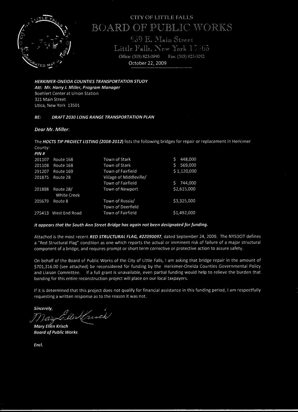
157
Chapter 3 - Goals, Objectives, & Strategies
 Chapter 3 - This chapter presents goals, objectives, and strategies that have been developed as part of the Richmond Area MPO 2026 Long-Range Transportation Plan (LRTP) update. Strategies have been developed
MOBILITY 2045: A FOCUS ON TRANSPORTATION CHOICE:
 Mobility 2045: The Metropolitan Transportation Plan for North Central Texas is the defining vision for the multimodal transportation system in the Dallas- Fort Worth Metropolitan Planning Area. The plan,
Summary of transportation-related goals and objectives from existing regional plans
 SMTC 2050 Long Range Transportation Plan Appendix A: Summary of transportation-related goals and objectives from existing regional plans SMTC 2050 Long Range Transportation Plan Summary of transportation-related
Tri-County Regional Planning Commission 2045 Regional Metropolitan Transportation Plan Goals and Objectives Adopted March 22, 2017
 Tri-County Regional Planning Commission 2045 Regional Metropolitan Transportation Plan Goals and Objectives Adopted March 22, 2017 One of the initial steps in the development of the TCRPC 2045 Metropolitan
Chapter 5 Transportation Draft
 Chapter 5 Transportation Draft Discussion Similar to the other elements in the Comprehensive Plan, the transportation element impacts the quality of life, economic development and public safety of the
Under recently updated FHWA guidelines, the LRTP must be updated every four (4) years. The most recent LRTP is the 2035 Plan, adopted in early 2009.
 years. The most recent LRTP is the 2035 Plan, adopted in early 2009.") PLANS, POLICIES AND PROCESSES OF THE MPO The Winston-Salem Urban Area MPO is responsible for creating and maintaining many documents essential to the on-going transportation planning effort. These documents
PLANS, POLICIES AND PROCESSES OF THE MPO The Winston-Salem Urban Area MPO is responsible for creating and maintaining many documents essential to the on-going transportation planning effort. These documents
Chapter 5 - Transportation
 Chapter 5 - Transportation Discussion Similar to the other elements in the Comprehensive Plan, the transportation element impacts the quality of life, economic development and public safety of the residents
Rapid City Area Metropolitan Planning Organization OPERATIONS PLAN
 Rapid City Area Metropolitan Planning Organization OPERATIONS PLAN Prepared for the Rapid City Area Metropolitan Planning Organization Endorsed by the Executive Policy Committee of the Rapid City Area
Rapid City Area Metropolitan Planning Organization OPERATIONS PLAN
 Rapid City Area Metropolitan Planning Organization OPERATIONS PLAN Prepared for the Rapid City Area Metropolitan Planning Organization Endorsed by the Executive Policy Committee of the Rapid City Area
PERFORMANCE-BASED PLANNING AND PROGRAMMING
 February 2017 performance-based planning and programming Boston Region MPO PERFORMANCE-BASED PLANNING AND PROGRAMMING WHAT IS PERFORMANCE-BASED PLANNING AND PROGRAMMING? Performance-based planning and
PERFORMANCE-BASED PLANNING AND PROGRAMMING
 February 2017 performance-based planning and programming Boston Region MPO PERFORMANCE-BASED PLANNING AND PROGRAMMING WHAT IS PERFORMANCE-BASED PLANNING AND PROGRAMMING? Performance-based planning and
VISION STATEMENT, MISSION STATEMENT, AND GOALS AND OBJECTIVES
 VISION STATEMENT, MISSION STATEMENT, AND GOALS AND OBJECTIVES Vision Statement: Our vision is to provide a high quality, safe, efficient, and cost-effective multi-modal transportation system that supports
EIGHT PLANNING FACTORS
 EIGHT PLANNING FACTORS Under the provisions of SAFETEA-LU, all Metropolitan Planning Organizations (MPOs) are required to consider eight (8) broad planning factors in the development of multi-modal transportation
Williamsport Area Transportation Study Metropolitan Planning Organization
 Williamsport Area Transportation Study Metropolitan Planning Organization LONG RANGE TRANSPORTATION PLAN 2018-2038 CHAPTER 1 INTRODUCTION Purpose of a Long Range Transportation Plan Transportation infrastructure
Chapter 10 Goals, Objectives + Policies
 Chapter 10 Goals, + Policies Warehouse on Nestle Way near I-78 114 115 10.1 ESTABLISHMENT OF CONSISTENT GOALS 10.2 NATIONAL FREIGHT GOALS The Lehigh Valley s freight transportation investment decisions
GOALS AND PERFORMANCE MEASURES
 PLANNING FRAMEWORK The planning framework guides the development of the Regional Transportation Plan, articulating what the region is trying to achieve. This chapter establishes a foundation to focus data-gathering
1 I N T R O D U C T I O N
 THE 2040 OKI REGIONAL TRANSPORTATION PLAN This is the metropolitan transportation plan for the Ohio-Kentucky-Indiana Regional Council of Governments (OKI). OKI is the federally designated regional transportation
CHAPTER 2. VISION, GOALS AND MTP FRAMEWORK
 CHAPTER 2. VISION, GOALS AND MTP FRAMEWORK MTP VISION In order to create a framework for the 2040 Metropolitan Transportation Plan (MTP), a vision statement was drafted by the Vision/Goals Committee and
CRTPA Regional Mobility Plan Attachment 1 Agenda Item 4E Page 1 of 11
 CRTPA Regional Mobility Plan Attachment 1 Page 1 of 11 INTRODUCTION Everyone wants to have the ability to move around the city, county, region, country and world in the way that they see fit, when they
Appendix E-1. FDOT MPO Program Management Handbook. (Excerpts)
") Appendix E-1 FDOT MPO Program Management Handbook (Excerpts) TABLE OF CONTENTS Chapter 4 Long-Range Transportation Plan Section Page 4.1 PURPOSE... 4-2 4.2 AUTHORITY... 4-2 4.3 SCOPE... 4-2 4.4 REFERENCES...
Appendix E-1 FDOT MPO Program Management Handbook (Excerpts) TABLE OF CONTENTS Chapter 4 Long-Range Transportation Plan Section Page 4.1 PURPOSE... 4-2 4.2 AUTHORITY... 4-2 4.3 SCOPE... 4-2 4.4 REFERENCES...
2. Goals and Objectives
 Pedestrians in Charlotte s busy Uptown. CRTPO Mission The mission of the Charlotte Regional Transportation Planning Organization (CRTPO) is to plan for transportation options that ensure mobility, respect
CITY OF JACKSONVILLE 2030 MOBILITY PLAN STUDY UPDATE GOALS, OBJECTIVES, AND PERFORMANCE MEASURES PREPARED FOR: CITY OF JACKSONVILLE
 CITY OF JACKSONVILLE 2030 MOBILITY PLAN STUDY UPDATE GOALS, OBJECTIVES, AND PERFORMANCE MEASURES 3.20.2017 PREPARED FOR: CITY OF JACKSONVILLE 55 Railroad Row White River Junction, VT 05001 802.295.4999
PERFORMANCE-BASED PLANNING AND PROGRAMMING
 September 2018 performance-based planning and programming Boston Region Metropolitan Planning Organization: PERFORMANCE-BASED PLANNING AND PROGRAMMING WHAT IS PERFORMANCE-BASED PLANNING AND PROGRAMMING?
- FACT SHEET - THE GUIDING PRINCIPLES
 THE GUIDING PRINCIPLES The General Plan begins with seven ideas that together create a vision for the City s future. When the City approved the General Plan in 1994, these idea were dubbed the Seven Guiding
Technical Memorandum#1A
 Technical Memorandum#1A Goals, Objectives, and Performance Measures AMATS 2040 Metropolitan Transportation Plan Prepared for: AMATS Prepared by: HDR Approved by AMATS PC September 28, 2017 This page intentionally
Transportation and Utilities
 4 Section 4 Transportation and Utilities 4.0 Introduction Transportation and utility systems are essential to accommodate and support development proposed in the Future Land Use Map. The following pages
Transportation Improvement Program (TIP) Relationship to 2040 Metropolitan Transportation Plan (MTP) - Goals and Performance Measures
 Relationship to 2040 Metropolitan Transportation Plan (MTP) - Goals and Performance Measures") Mid-Region Metropolitan Planning Organization Mid-Region Council of Governments 809 Copper Avenue NW Albuquerque, New Mexico 87102 (505) 247-1750-tel. (505) 247-1753-fax www.mrcog-nm.gov Transportation
Mid-Region Metropolitan Planning Organization Mid-Region Council of Governments 809 Copper Avenue NW Albuquerque, New Mexico 87102 (505) 247-1750-tel. (505) 247-1753-fax www.mrcog-nm.gov Transportation
GUIDING PRINCIPLES MEMORANDUM
 M E T R O P O L I TAN TRA NS P O RTATI O N PLAN GUIDING PRINCIPLES MEMORANDUM El Paso Metropolitan Planning Organization INTRODUCTION The guiding principles for development of the El Paso MPO s Destino
CHAPTER 8 TRANSPORTATION ELEMENT
 CHAPTER 8 TRANSPORTATION ELEMENT Section 8.01 Purpose: The purpose of this Chapter (element) is to establish the desired and projected transportation system within Niceville and to plan for future motorized
The Role of Transportation Systems Management & Operations in Supporting Livability and Sustainability
 The Role of Transportation Systems Management & Operations in Supporting Livability and Sustainability Michael Grant, ICF International February 7, 2012 NTOC Webinar Highlights of FHWA/FTA Primer Background:
MTP VISIONS, GOALS, AND OBJECTIVES
 2 MTP VISIONS, GOALS, AND OBJECTIVES El Paso MPO 2045 Metropolitan Transportation Plan 2. GUIDING PRINCIPLES This chapter describes the process by which the vision and goals of the planning process were
CHAPTER 1 INTRODUCTION
 CHAPTER 1 INTRODUCTION 1.1 ABOUT THE FREDERICKSBURG AREA METROPOLITAN PLANNING ORGANIZATION Established in 1992, the Fredericksburg Area Metropolitan Planning Organization (FAMPO) is the federally designated
The Policies section will also provide guidance and short range policies in order to accomplish the goals and objectives.
 4 Goals & Objectives INTRODUCTION The 2015-2040 MTP preserves and promotes the quality of life and economic prosperity of the MAB by providing a transportation system consistent with the regional goals.
PURPOSE OF THE TRANSPORTATION IMPROVEMENT PROGRAM (TIP)
") INTRODUCTION PURPOSE OF THE TRANSPORTATION IMPROVEMENT PROGRAM (TIP) The Transportation Improvement program (TIP) is a staged, four-year program of projects proposed for funding by federal, State, and
INTRODUCTION PURPOSE OF THE TRANSPORTATION IMPROVEMENT PROGRAM (TIP) The Transportation Improvement program (TIP) is a staged, four-year program of projects proposed for funding by federal, State, and
2040 Addendum Performance-Based Planning November 2018
 2040 Long Range Transportation Plan 2040 Addendum Performance-Based Planning November 2018 Adopted June 13, 2018 250 S. Orange Ave, Suite 200, Orlando, FL 32801 407-481-5672 www.metroplanorlando.org MetroPlan
7.0 TRANSPORTATION MANAGEMENT
 7.0 TRANSPORTATION MANAGEMENT I. Introduction/Current State of Transportation Management in KC Region The Kansas City region has invested considerable effort and resources in the design and implementation
Going Forward The Plan to Maintain & Improve Mobility Frequently Asked Questions (FAQs)
") Going Forward The Plan to Maintain & Improve Mobility Frequently Asked Questions (FAQs) What is Going Forward The Plan to Maintain & Improve Mobility (Plan) and why does the region need a Long Range Transportation
Going Forward The Plan to Maintain & Improve Mobility Frequently Asked Questions (FAQs) What is Going Forward The Plan to Maintain & Improve Mobility (Plan) and why does the region need a Long Range Transportation
12 Evaluation of Alternatives
 12 Evaluation of Alternatives This chapter evaluates the effectiveness of the No-Build Alternative and the proposed METRO Blue Line Light Rail Transit (BLRT) Extension project based on the information
Corpus Christi Metropolitan Transportation Plan Fiscal Year Introduction:
 Introduction: Traffic congestion in the Corpus Christi Metropolitan area is not as much a function of population growth as the function of the increase in single occupant trips. Using census data, the
2. Guiding Principles, Objectives, and Policies
 2. Guiding Principles, Objectives, and Policies INTRODUCTION The guiding principles for the 2040 MTP Update establish the vision and key focus areas for this planning effort. They combine the guidance
APPENDIX A PLANNING PROCESS FOR RURAL AREAS OF THE STATE
 APPENDIX A PLANNING PROCESS FOR RURAL AREAS OF THE STATE Background SCDOT Statewide Transportation Planning Process Consultation Cooperation with Local Officials in Non-Metropolitan (Rural) Areas SCDOT
MONITORING IMPLEMENTATION AND PERFORMANCE
 12 MONITORING IMPLEMENTATION AND PERFORMANCE The FAST Act continues the legislation authorized under MAP-21, which created a data-driven, performance-based multimodal program to address the many challenges
WTP 2035 DRAFT STRATEGIES AND ACTIONS
 INTRODUCTION This Working Paper presents draft strategies and actions to be considered for inclusion in the draft Washington Transportation Plan 2035. It includes reference to the existing WTP 2030 strategies
20-Year State Highway Investment Plan. Appendix C ACRONYMS AND GLOSSARY APPENDIX C ACRONYMS AND GLOSSARY PAGE C-1
 20-Year State Highway Investment Plan Appendix C APPENDIX C PAGE C-1 This page intentionally left blank. PAGE C-2 MINNESOTA GO 20- YEAR HIGHWAY INVESTMENT PLAN 2018-2037 Acronyms ADA APS ATM ATP BRIM CAFE
Chapter 2 Transportation Element Goals, Objectives and Policies
 Chapter 2 Transportation Element Goals, Objectives and Policies City of Belleview Comprehensive Plan Adopted by Ord 2016-10 on July 5, 2016 GOALS, OBJECTIVES AND POLICIES Goal 2 Transportation...1 Objective
Winston-Salem Urban Area Metropolitan Planning Organization (WSUAMPO) Prioritization 3.0 Evaluation Criteria and Point Assignment Process
 Prioritization 3.0 Evaluation Criteria and Point Assignment Process") The following methodology has been developed by the Winston-Salem Urban Area Metropolitan Planning Organization (WSUAMPO) for the purpose of determining priorities for transportation funding, as carried
The following methodology has been developed by the Winston-Salem Urban Area Metropolitan Planning Organization (WSUAMPO) for the purpose of determining priorities for transportation funding, as carried
CHAPTER 1: INTRODUCTION/ GOALS AND OBJECTIVES
 CHAPTER 1: INTRODUCTION/ GOALS AND OBJECTIVES 1.1: INTRODUCTION ABOUT THE FREDERICKSBURG AREA METROPOLITAN PLANNING ORGANIZATION (FAMPO) Established in 1992, the Fredericksburg Area Metropolitan Planning
THE REGION S PLAN POLICY FRAMEWORK. August 2015
 THE REGION S PLAN POLICY FRAMEWORK August 2015 2 What is The Policy Framework? Cover photo credit: Sinan Sinharoy for Atlanta BeltLine, Inc. Atlanta is one of the world s most dynamic metropolitan areas,
Syracuse Metropolitan Transportation Council DRAFT PUBLIC PARTICIPATION PLAN
 Syracuse Metropolitan Transportation Council DRAFT PUBLIC PARTICIPATION PLAN 1. Introduction As the Metropolitan Planning Organization (MPO) designated by the Governor of the State of New York, the Syracuse
Chapter 14 Work Program
 Chapter 14 Work Program The Metropolitan Council will carry out or participate in many studies and plans over the next three years. This is not an exhaustive list of all work to be completed by the Metropolitan
Congestion Management Process (CMP)
") Congestion Management Process (CMP) Introduction The Congestion Management Process (CMP) is a systematic, data-driven, and regionally accepted approach that aims to improve the performance of the transportation
Congestion Management Process (CMP) Introduction The Congestion Management Process (CMP) is a systematic, data-driven, and regionally accepted approach that aims to improve the performance of the transportation
RURAL CENTER COMMUNITY ROLE COUNCIL ROLE RURAL CENTER ALL COMMUNITIES
 Orderly and Efficient Land Use Align land use, development patterns, and infrastructure to make the best use of public and private investment. Plan for forecasted population and household growth at overall
Moving Forward 2040 Long Range Transportation Plan Bicycle Mobility Master Plan Transit Master Plan
 Moving Forward 2040 Long Range Transportation Plan Bicycle Mobility Master Plan Transit Master Plan Paul DiGiuseppe Assistant Chief, Division of Planning Department of Administration (DOA) Needed to keep
CHAPTER 3 THE BUILDING BLOCKS POLICIES AND SUPPORTIVE STRATEGIES REGIONAL TRANSPORTATION PLAN/SUSTAINABLE COMMUNITIES STRATEGY
 CHAPTER 3 THE BUILDING BLOCKS POLICIES AND SUPPORTIVE STRATEGIES REGIONAL TRANSPORTATION PLAN/SUSTAINABLE COMMUNITIES STRATEGY CHAPTER 3 THE BUILDING BLOCKS POLICIES AND SUPPORTIVE STRATEGIES INTRODUCTION
PennDOT Office of Planning
 Every Voice Counts PennDOT Office of Planning Environmental Justice Plan Executive Summary Developed for: Pennsylvania Department of Transportation Office of Planning Center for Program Development and
RESOLUTION NO
 RESOLUTION NO. 2018-12 RESOLUTION OF THE SOUTHEASTERN WISCONSIN REGIONAL PLANNING COMMISSION AMENDING THE TRANSPORTATION IMPROVEMENT PROGRAM FOR SOUTHEASTERN WISCONSIN: 2017-2020 WHEREAS, the Southeastern
TCATS October 12-Michigan Works 5:30-7pm. NATS October 19-Niles District Library 6-7:30pm
 Goal Development Workshop TCATS October 12- Works 5:30-7pm NATS October 19-Niles District Library 6-7:30pm SAFETEA-LU Goals 2035 TwinCATS Goals 2030 TwinCATS Goals 1. Support the economic vitality of the
Winston-Salem Urban Area Metropolitan Planning Organization (WSMPO) Prioritization 4.0 Evaluation Criteria and Point Assignment Process
 Prioritization 4.0 Evaluation Criteria and Point Assignment Process") The following methodology was developed by the Winston-Salem Urban Area Metropolitan Planning Organization (WSMPO) for the purpose of determining priorities for transportation funding, as carried out through
The following methodology was developed by the Winston-Salem Urban Area Metropolitan Planning Organization (WSMPO) for the purpose of determining priorities for transportation funding, as carried out through
APPENDIX A - PLANS AND POLICY REVIEW FEBRUARY 2017
 APPENDIX A - PLANS AND POLICY REVIEW FEBRUARY 2017 DENVERMOVES Transit Denver Moves: Transit APPENDIX A PLANS AND POLICY REVIEW 2035 Metro Vision Regional Transportation Plan (MVRTP) (2011) 2040 Fiscally
SUBURBAN EDGE COMMUNITY ROLE COUNCIL ROLE ALL COMMUNITIES SUBURBAN EDGE
 Orderly and Efficient Land Use Align land use, development patterns, and infrastructure to make the best use of public and private investment. Plan and stage development for forecasted growth through 2040
MEMORANDUM #4. DATE: November 4, Warrenton TSP Project Management Team. Ray Delahanty, AICP, DKS Associates Kate Petak, EIT, DKS Associates
 MEMORANDUM #4 DATE: November 4, 2015 TO: FROM: SUBJECT: Warrenton TSP Project Management Team Ray Delahanty, AICP, DKS Associates Kate Petak, EIT, DKS Associates Warrenton Transportation System Plan Update
Table Table 7.2 Potential Environmental Impacts and Mitigation Measures
 7.2 Natural Environment/Environmental Planning Executive Summary/Key Points The Environmental Consultation and Mitigation Plan establishes: o A process for consultation with environmental resource agencies
TRANSPORTATION RELATIONSHIP TO OTHER ELEMENTS OF THE PLAN AND COUNTY REGULATIONS VISION FOR TRANSPORTATION PLANNING ROAD NETWORK SECTION 7
 TRANSPORTATION Like many growing western counties, Douglas County focuses on one of the most integral elements in land-use planning: transportation. The primary purpose of a transportation network is to
FY 2019 Unified Planning Work Program FINAL. Regional Intergovernmental Council. June 14, Kanawha Putnam Metropolitan Planning Organization
 FY 2019 Unified Planning Work Program FINAL Regional Intergovernmental Council Kanawha Putnam Metropolitan Planning Organization June 14, 2018 315 D Street. South Charleston, WV. 25303 The Unified Planning
MEETING SUMMARY FOR APRIL 13, 2017
 SARASOTA/MANATEE METROPOLITAN PLANNING ORGANIZATION Performance Measures/Project Prioritization Process Ad Hoc Committee 7632 15 th Street East Sarasota, Florida 34243 3:00-5:00 PM MEETING SUMMARY FOR
2016 Cape Cod Regional Transportation Plan Development
 2016 Cape Cod Regional Transportation Plan Development APRIL 2015 PUBLIC MEETING PRESENTATION REGIONAL TRANSPORTATION P LAN ( RTP) + Long-range plan (2016-2040) + Includes all modes + Establishes the regional
POLK COUNTY TPO Polk County 2060 Transportation Vision Plan Final Report. ADOPTED June 18, 2009
 POLK COUNTY TPO Polk County 2060 Transportation Vision Plan Final Report ADOPTED June 18, 2009 TABLE OF CONTENTS CHAPTER 1 Introduction and Prior Planning Effort...Page 1-1 CHAPTER 2 Population and Employment
RURAL RESIDENTIAL COMMUNITY ROLE COUNCIL ROLE RURAL RESIDENTIAL ALL COMMUNITIES
 Orderly and Efficient Land Use Align land use, development patterns, and infrastructure to make the best use of public and private investment. Discourage future development of rural residential patterns
Moving Ahead for Progress in the 21 st Century MAP-21
 Moving Ahead for Progress in the 21 st Century MAP-21 Mark Newland Transportation Finance Manager FHWA Indiana Division Purdue Road School March 6, 2013 Agenda Review changes between SAFETEA-LU and MAP-21.
1.0 Introduction to Transportation Planning
 1.0 Introduction to Transportation Planning A good plan is like a road map: it shows the final destination and usually the best way to get there. H. Stanley Judd 1.1 Purpose Why is Transportation Planning
10.0 ENVIRONMENTAL INTEGRATION
 10.0 ENVIRONMENTAL INTEGRATION Transportation projects in the Kansas City region commonly face a range of complex, interrelated environmental and community issues. These often relate to NEPA requirements
AICP EXAM REVIEW. Transportation Planning. February 19, 2016
 AICP EXAM REVIEW Transportation Planning February 19, 2016 Agenda Defining transportation planning Transportation stakeholders Transportation plan development Transportation funding Project development
Transportation and Land Use Planning Connectivity
 Chapter 3 Transportation and Land Use Planning Connectivity CHAPTER 3 Transportation and Land Use Planning Connectivity INTRODUCTION Transportation systems and services are provided in the context of both
PUBLIC PARTICIPATION PLAN
 PUBLIC PARTICIPATION PLAN INTRODUCTION The purpose of the Public Participation Plan (PPP) is to outline methods for encouraging citizens, affected organizations and other interested parties to be involved
Let s Keep Moving 2036: Policy Plan
 1 P a g e This Page Intentionally Blank Alaska Statewide Long-Range Transportation Plan September 2016 A MESSAGE FROM THE COMMISSIONER To All Alaskans: The Alaska Department of Transportation and Public
Environmental Impact Statement for the Green Line to the Airport Project. ACTION: Notice of Intent to Prepare an Environmental Impact Statement (EIS).
.") This document is scheduled to be published in the Federal Register on 11/18/2015 and available online at http://federalregister.gov/a/2015-29418, and on FDsys.gov DEPARTMENT OF TRANSPORTATION Federal Transit
This document is scheduled to be published in the Federal Register on 11/18/2015 and available online at http://federalregister.gov/a/2015-29418, and on FDsys.gov DEPARTMENT OF TRANSPORTATION Federal Transit
Chapter 12: Transportation Safety & Security CHARLOTTE COUNTY PUNTA GORDA MPO 2035 LONG RANGE TRANSPORTATION PLAN
 Chapter 12: Transportation Safety & Security CHARLOTTE COUNTY PUNTA GORDA MPO 2035 LONG RANGE TRANSPORTATION PLAN CHARLOTTE COUNTY PUNTA GORDA MPO 2035 LONG RANGE TRANSPORTATION PLAN Transportation Safety
Addendum #3 to the Regional Transportation Plan
 Nashville Area Metropolitan Planning Organization Addendum #3 to the Regional Transportation Plan Effective November 21, 2018 Nashville Area Metropolitan Planning Organization 138 Second Avenue North Nashville,
Proposed Comprehensive Update to the State of Rhode Island s Congestion Management Process
 Proposed Comprehensive Update to the State of Rhode Island s Statewide Planning Program January 2018 Summary Outline of of Action Steps 1. Develop Objectives for Congestion Management What is the desired
Kentucky River Area Development District
 Kentucky River Area Development District Regional Transportation Planning Committee DRAFT Regional Goals & FY 2016 Approved: August 12, 2015 KYTC MISSION STATEMENT: To provide a safe, secure, and reliable
DIVERSIFIED RURAL COMMUNITY ROLE COUNCIL ROLE DIVERSIFIED RURAL ALL COMMUNITIES
 Orderly and Efficient Land Use Align land use, development patterns, and infrastructure to make the best use of public and private investment. Plan for growth not to exceed forecasts and in patterns that
1: INTRODUCTION AND PROCESS OVERVIEW
 GPATS Long-Range Transportation Plan 1: INTRODUCTION AND PROCESS OVERVIEW INTRODUCTION affects everyone in many ways and plays a critical role in shaping a region s physical and social infrastructure.
CONNECTING LAND USE AND TRANSPORTATION PLANNING THE LINKAGE MODEL FOR METROPOLITAN PLANNING ORGANIZATIONS
 NEW YORK STATE ASSOCIATION OF METROPOLITAN PLANNING ORGANIZATIONS CONNECTING LAND USE AND TRANSPORTATION PLANNING THE LINKAGE MODEL FOR METROPOLITAN PLANNING ORGANIZATIONS Prepared by Chris O'Neill, CDTC
EVALUATION OF ALTERNATIVES CARRIED FORWARD
 1 EVALUATION OF ALTERNATIVES CARRIED FORWARD This chapter presents a comparative evaluation of the alternatives carried forward in this Final Environmental Impact Statement (EIS). The intent of this evaluation
2040 Long Range Transportation Plan
 2040 Long Range Transportation Plan Presented by Iowa Northland Regional Council of Governments October 22, 23, and 24, 2013 Liaison for federal transportation funding that goes to local cities and counties
2017 TRANSPORTATION POLICY STATEMENT
 0 TRANSPORTATION POLICY STATEMENT 1 1 1 1 1 1 0 1 0 1 0 1 Critical investments are needed to maintain and improve Virginia s transportation network. The structural imbalance between critical needs and
6 CHARTING PERFORMANCE
 DRAFT 6 CHARTING PERFORMANCE OVERVIEW OF PERFORMANCE BASED PLANNING Background of Performance Based Planning Increasingly, over the past two decades, transportation agencies have been utilizing performance
Chapter 4: Transportation and Land Use
 Chapter 4: Transportation and Land Use Transportation and land use together make possible the wide range of destination opportunities in the region. Transportation provides the connections, and, in turn,
Safety and Security for Residents, Visitors, and Businesses
 Safety and Security for Residents, Visitors, and Businesses SAFETY Design roadways mindful of the most vulnerable users Reduce user-related crashes of all modes Promote collaboration, safety awareness,
Appendix O Congestion Management Program REGIONAL TRANSPORTATION PLAN/SUSTAINABLE COMMUNITIES STRATEGY
 Appendix O Congestion Management Program REGIONAL TRANSPORTATION PLAN/SUSTAINABLE COMMUNITIES STRATEGY 2014 REGIONAL CONGESTION MANAGEMENT PROGRAM 2014 RTP/SCS APPENDIX O SAN JOAQUIN COUNCIL OF GOVERNMENTS
CHAPTER 1. A New Transportation Plan
 Chapter 1. A New Transportation Plan 1 CHAPTER 1. A New Transportation Plan Why develop a new plan? The year 2005 marks 90 years since Anchorage emerged as a community serving as headquarters for railroad
Updated Summer
 1 Access Board An independent federal agency devoted to accessibility for people with disabilities. The Access Board developed the accessibility guidelines for the ADA and provides technical assistance
APPENDIX A. Plan Survey Detail. Doug Kerr (Flickr)
") APPENDIX A Plan Survey Detail Doug Kerr (Flickr) Table of Contents Page APPENDIX A Plan Survey Detail... A-1 Statewide Plans and Policies... A-3 County Plans and Policies... A-6 Local Jurisdiction Plans
APPENDIX A Plan Survey Detail Doug Kerr (Flickr) Table of Contents Page APPENDIX A Plan Survey Detail... A-1 Statewide Plans and Policies... A-3 County Plans and Policies... A-6 Local Jurisdiction Plans
Introduction. Performance Measurement. Pg. 01
 Pg. 01 Introduction The Alamo Area recognizes the importance of transportation performance tracking, goal setting and measurement to provide greater accountability and transparency and to achieve a more
BUS RAPID TRANSIT CORRIDOR
 DOWNTOWN UPTOWN OAKLAND EAST END BUS RAPID TRANSIT CORRIDOR Scoping Booklet for National Environmental Policy Act Review City of Pittsburgh Port Authority of Allegheny County Uptown/Downtown Scoping Meeting
Freight and Rail Stakeholder Webinar. January 7, 2014
 Freight and Rail Stakeholder Webinar January 7, 2014 Agenda Modal Needs Baseline Revenue Modal Scenarios Website Statewide Freight Plan Statewide Rail Plan Jeff Carroll MULTIMODAL TRANSPORTATION NEEDS
Metropolitan Council PUBLIC PARTICIPATION PLAN. for Transportation Planning and Programming
 Metropolitan Council PUBLIC PARTICIPATION PLAN for Transportation Planning and Programming Introduction and Federal Requirement Public participation is an essential element of planning in the Twin Cities
URBAN CENTER COMMUNITY ROLE COUNCIL ROLE ALL COMMUNITIES URBAN CENTER
 Orderly and Efficient Land Use Align land use, development patterns, and infrastructure to make the best use of public and private investment. Plan for forecasted population and household growth at average
2040 Transportation Policy Plan Amendment #1
 2040 Transportation Policy Plan Amendment #1 Overview Amendment Purpose This 2040 Transportation Policy Plan amendment adds the Riverview Modern Streetcar transitway project to the Current Revenue Scenario.
ACTIVE TRANSPORTATION ADVISORY COMMITTEE. Memphis MPO March 30, 2015
 ACTIVE TRANSPORTATION ADVISORY COMMITTEE Memphis MPO March 30, 2015 Agenda Welcome & Introductions Announcements and Briefings Livability 2040: Regional Transportation Plan Congestion Management Process