Interstate 70 Corridor Study
|
|
|
- Alexia Ball
- 6 years ago
- Views:
Transcription

1 Clark County, Ohio Interstate 70 Corridor Study prepared by Clark County-Springfield Transportation Coordinating Committee with Ohio Department of Transportation Office of Urban and Corridor Planning and District Seven March 2002 The preparation and publication of this document was financed cooperatively by the Federal Highway Administration, the Federal Transit Administration, the Ohio Department of Transportation, Clark County, the City of Springfield and the West Central Ohio Port Authority.
2 Clark County-Springfield Transportation Coordinating Committee John W. Sesslar, Chairman Robert A. Warren, Vice Chairman John Baird Dwain Bartley Darryl Bauer Elmer Beard Nancy Brown Jim Campbell James Caplinger Randy Chevalley John Detrick William George Tim Gothard Herb Greer Leonard Hartoog W. Darrell Howard Tom Junk Toni Keller Gene Kelly John Klosterman David Locke Martin Mahoney Dan Martin Bob McKie Nancy Pence James Sheehan Bruce Smith Geoff Steele Roger Tackett Marjorie Travis Ned Weber Sarah Wildman Paul Wilson Clark County-Springfield Transportation Study Larry W. Himes Transportation Director J. Lamar Daniel Transportation Planner II Eric B. Ottoson Transportation Planner II Peggy S. Holland Transportation Planner II Joyce A. Davis Administrative Secretary Sue E. Harber Bookkeeper Phone (937) Fax (937)
3 Table of Contents INTRODUCTION...1 PROBLEM STATEMENT...2 Study Area...2 Study Process...4 Land Use Patterns and Trends...4 Existing and Future Conditions...4 COORDINATION ACTIVITIES...7 Pre-Scope Meeting...7 Scoping Meetings...7 Public Involvement and Public Outreach Summary...11 ALTERNATIVES...11 Alternatives Analyses Discussions...11 PREFERRED ALTERNATIVE...22 Additional Items for Further Study...23 Document Attachments Corridor Study Alternatives Work Sheet...25 Section Metropolitan Planning Regulations (10/28/93)...26 MIS Scoping Committee Prospective Members List...28 Tables Charts Maps EXHIBITS Table 1: Interstate Daily Traffic Counts...20 Table 2: Interstate Projected ADT...21 Chart 1: I-70 Vehicles per Lane...5 Chart 2: I Traffic Counts per Lane...20 Chart 3: I Projected Traffic Counts Per Lane...21 Chart 4: I-70 Truck Counts...22 Map1: MIS Study Area...3 Map 2: Interstate 70 ADT Map...6 Map 3: Interstate 70 Level of Service Map...8 Map 4: Interstate 70 Projected Construction Schedule...24
4 The Intermodal Surface Transportation Efficiency Act of 1991 (ISTEA) established planning principles involving the alternative transportation investment analysis requirement for metropolitan area corridors or sub-areas where high cost or high impact transportation solutions are being considered. The U.S. Department of Transportation created the Major Investment Study (MIS) process in the final Metropolitan Planning rules issued October 28, 1993 for implementation of these principles. An MIS is performed where federal funds are potentially involved in the development and construction of major transportation projects of substantial cost and impact. The study defines a transportation system problem or deficiency, suggests possible alternative modal solutions, evaluates the alternatives, and recommends a preferred course of action. The purpose of an MIS is to provide the region s transportation decision makers with a tool to assist in evaluating alternatives to solve the defined problem and to refine the transportation plan. The Transportation Equity Act for the 21 st Century (TEA-21) was signed into law in June The Bill replaced the requirement for a stand-alone major investment study with a directive that such analyses, under the planning provisions of TEA-21 and the National Environmental Policy Act, are to be integrated. INTRODUCTION The Interstate, as it is currently configured through Clark County, is quickly becoming an outdated facility. The growth of interstate markets and the central location of this major corridor is important not only to the local economy, but to the state and the nation, as well. It is imperative to ensure this route does not become so congested as to be unusable in the future. A major investment study must be undertaken in order to ensure the best solutions are developed for the limited resources available. Additionally: The primary east-west vehicular route across Clark County, the state of Ohio and the nation is Interstate 70. As growth occurs and traffic increases along this extremely important corridor, it is apparent that the roadway designs of the 1950 s and 1960 s will no longer be sufficient to support the ever increasing needs of the traveling public. Interstate 70 is extremely important for the efficient movement of people and goods across the metropolitan planning area, especially for interstate and regional travel. It plays a key role in the development of transportation plans and occupies a primary point of emphasis in the Transportation Improvement Program. The agencies responsible for the completion of the Corridor Study are the Clark County-Springfield Transportation Coordinating Committee (TCC), which consists of the staff members of the metropolitan planning organization for the Springfield metropolitan area and the Ohio Department of Transportation. The goals of this MIS were to study the Interstate 70 Corridor with an eye to the future and to explore the possibilities for ensuring the adequacy of the corridor for the most efficient possible movement of people and goods. 1
5 The Dayton/Springfield area was a non-attainment area for the pollutant ozone, as set forth in the 1990 Clean Air Act Amendments (CAAA). In July 1995, the area was redesignated to attainment status, and is now a maintenance area. As a consequence of this designation, any transportation improvement recommendation resulting from this MIS must meet the CAAA transportation conformity requirements. The conformity requirements involve a quantitative analysis of the regional emissions that are generated from vehicles traveling over the transportation network. The analysis must demonstrate that the total regional emissions are less than the emission budgets established in the State Implementation Plan for air quality. PROBLEM STATEMENT The basic problem which has been identified for the Interstate 70 corridor in Clark County is: The current traffic volumes, especially truck volumes, on some sections of Interstate 70 through Clark County, are at unacceptable levels of congestion, especially during the peak hours. Forecasted traffic volumes, based upon current growth rates and future development will result in additional portions of the route experiencing congestion and unacceptable levels of delay. Study Area The boundaries of the study area are as follows: West State Route 235 South Clark County line/one mile south of Norfolk Southern Rail line East State Route 56 North One mile north of US 40 Study Process The Scoping/Pre-scoping Committee agreed that the study would identify alternatives for the corridor with the overall goal of improving mobility. Public meetings would be held to receive input from the traveling public. Other studies which have recently been completed demonstrating need and transportation improvements in the study area are as follows: Traffic Efficiency and Flow Study (ODOT) Freight Study (Reebie & Associates/ODOT) Statewide Interstate Rehabilitation Study (ODOT) 3C Corridor Study (ORDC) Clark County-Springfield 2025 Long Range Transportation Plan 2
6 Map 1 Interstate 70 Study Area MIS Study Area Clark tu 68 OP 4 OP 41 OP 334 OP 235 Springfield tu 40 tu OP OP 54 OP 56 London Legend Enon 70 tu OP 72 OP 41 tu 42 Madison Interstate 70 Study Area Miles µ Prepared by P.S. Holland Clark County-Springfield Transportation Study January 23, 2002 Clark County-Springfield Transportation Coordinating Committee March 2002
7 The study process for this MIS is outlined below: 1. Examine previous studies that have documented travel demand within the corridor. A significant amount of recent work has examined transportation alternatives covering all or portions of the study area. The conclusions and recommendations from those studies could then be used as major inputs to select a preferred transportation alternative for the current study area. 2. Seek public input at public involvement meetings in the corridor. 3. Incorporate issues from the public involvement meetings into the study. 4. MIS Scoping Meeting to be held with the corridor stakeholders. 5. A preferred alternative to be developed and selected for the corridor by the stakeholders. 6. The process and procedures of the MIS will be distributed as an MIS publication for purposes of fulfilling the intent of the ISTEA legislation. This document describes the MIS process for the I-70 corridor. 7. MIS results will be presented to the Clark County-Springfield Transportation Coordinating Committee for formal adoption and incorporation into the Long Range Transportation Plan. Land Use Patterns and Trends The current land use patterns and trends for the study area/region include both commercial and residential growth. Local land use policies are outlined in the Clark County Comprehensive Plan, which was adopted in It stresses the regional transportation network, linkages between the economy, land use and transportation, annexation, the cost of building and maintaining public infrastructure, urban sprawl, farmland preservation and other socio-economic issues. Existing and Future Conditions Interstate 70 is currently configured with 6 lanes from 0.51 miles east of the Montgomery County line to 0.2 miles west of the SR4 ramps. It is configured as 4 lanes throughout the rest of the study area. A project to extend the 6 lane section from 0.2 miles west of the SR4 ramps to the Enon Rd. ramps will be undertaken in SFY2002. There are 10 interchanges within the study area. Traffic counts were taken between each of these interchanges in There are 21 overpasses and 14 sets of bridges within the study area. A rest area is located at the Clark/Madison County line. This is one of only two rest areas in the western half of the state and is therefore very busy, primarily as a resting place for trucks. Highways ` Interstate 70 is comprised of a 4.82 mile 6 lane section in the western quarter of the county and a mile 4 lane section through the remainder of the county. 4
8 ` The primary nature of trips on I-70 in the study area consists of through traffic which does not have either an origin or destination in Clark County. ` The 1998 ADT at 9 locations from west to east in the corridor is depicted on map 2 (See table 1 on page 21 for additional information.) ` The 1998 Level of Service of I-70 through the study area is C. Projected declining Level of Service for the year 2025 determinations are depicted in map 3 The parallel route, US40, is configured with 2 lanes from the western edge of the study area to its junction with SR4. It is configured as an urban primary arterial through the city of Springfield. It is then configured with 4 lanes with median to the eastern limit of the study area. I-70 Vehicles per Lane (Current Configuration) cars trucks Chart 1 Interstate 70: 1998 Vehicles per Lane, Selected Locations Transit Transit is available only in the city of Springfield. It is limited to weekday daytime service. Comparable paratransit services are available throughout the urbanized area. Limited intercity bus service is available in the study area. 5
9 Map 2 Interstate 70: 1998 ADT at Selected Locations Interstate 70 ADT (1998) Clark tu 68 OP 4 OP 41 OP 334 Springfield tu OP 235 tu 40 3 OP OP 54 1 Legend 70 Enon tu OP 72 OP 41 tu 42 Interstate 70 ADT 60,000 Miles µ CAR TRUCK Prepared by P.S. Holland Clark County-Springfield Transportation Study January 23, 2002 Clark County-Springfield Transportation Coordinating Committee March 2002
10 COORDINATION ACTIVITIES Federal planning regulations require Major Investment Studies to be conducted in cooperation with all parties (transportation stakeholders) potentially affected by transportation system investments. When an implementing agency wishes to initiate an MIS, a scoping meeting must be convened, with the regional transportation stakeholders to solicit their involvement in the MIS process. The scoping meeting is to determine the extent of the analyses and agency roles in a cooperative process which involves the Metropolitan Planning Organization, the state DOT, public transit operators, environmental, resource, and permit agencies, local officials, the Federal Highway Administration (FHWA) and the Federal Transit Administration (FTA), and where appropriate community development organizations and other related agencies. This cooperative process shall establish the range of alternatives to be studied, such as alternative modes and technologies (including intelligent vehicle and highway systems), general alignment, number of lanes, the degree of demand management, and the operating characteristics. (Section Metropolitan Planning Regulations, October 28, 1993). Pre-Scope Meeting This meeting was held on May 12, 2000, by what is generally considered to be a working group, although the working group is not a required component of the MIS process. Its members were also members of the Scoping Committee. They were from the following organizations: Clark County-Springfield TCC Staff, Ohio Department of Transportation Central Office and District 7 Planning and Environmental staff, Clark County Engineer, and Springfield City Engineer. The MIS process was discussed and a course of action was established for the accomplishment of the study. The working group established the framework for the MIS and undertook a variety of activities, including the gathering of essential data and information, narrowing the number of alternatives to be analyzed for the MIS, utilizing the attached Corridor Study Alternatives Work Sheet, conducting the alternatives analyses for the MIS, and other activities that were better accomplished by a small working group. Areas of responsibility were determined with TCC staff members taking the lead. The problem was defined and a formal statement adopted for recommendation. Scoping Meetings As cited above, Section of the Metropolitan Planning Regulations of October 28, 1993 includes the following as members of a Scoping Committee:...the MPO, the State Department of Transportation, public transit operators, environmental, resource and permit agencies, local officials, the FHWA, the FTA, 7
11 Map 3 Interstate 70: Level of Service 2025 Interstate 70 Level of Service Clark tu 68 OP 4 OP 41 OP Springfield tu 40 OP 235 tu 40 OP 4 OP 54 OP 41 LOS Enon tu OP 72 tu 42 C D Miles µ E F Prepared by P.S. Holland Clark County-Springfield Transportation Study January 23, 2002 Clark County-Springfield Transportation Coordinating Committee March 2002
12 and where appropriate, community development agencies, major governmental housing bodies, and such other related agencies as may be impacted by the proposed scope of analysis. It goes on to say that a...reasonable opportunity... shall be provided for citizens and interested parties including affected public agencies, representatives of transportation agency employees, and private providers of transportation to participate in the cooperative process. The transportation stakeholders in Clark County were invited to attend meetings on August 16, 2000, October 25, 2000, March 9, 2001, and September 14, 2001 to review the MIS process, conclusions, and recommendations and to select a preferred alternative. ` August 16, 2000 Scoping Meeting A Scoping Meeting was held on August 16, 2000, in the Springfield City Forum. Leaders from communities along the corridor were invited, along with Ohio Department of Transportation Central and District Seven Office s planning staffs, FHWA Ohio Division (representing FHWA and FTA, in this region), and TCC. Displays of the study area depicted railroad crossings, notable features, selected accident locations and car/truck ADT. Discussion was led by Larry Himes, Transportation Director, TCC and Libby Rushley, ODOT Central Office of Urban and Corridor Planning. It was primarily centered on identifying the range of reasonably available modal alternatives for addressing the transportation system deficiencies identified in the I-70 MIS problem statement. The scoping meeting attendees overwhelmingly agreed that the MIS needed to evaluate the addition of a third I-70 mainline lane through the entire corridor. Ms. Rushley encouraged the scoping meeting attendees to include Travel Demand Management (TDM) strategies, highway operational improvements, and an analysis of transit alternatives in the MIS analysis. The scoping meeting attendees agreed to these suggestions. A major concern voiced by several meeting attendees was the large percentage of trucks traversing this segment of I-70. Truck traffic is expected to continue to increase because of additional truck terminal activity in the corridor. Some commuters use this corridor, but it does not directly link with the downtown area, or the high retail area on the west side. In summary, the scoping meeting attendees agreed this MIS will analyze the following modal alternatives to address the transportation deficiencies in the Clark County section of I-70: 1. The addition of a third Interstate mainline lane 2. Travel demand reduction and highway operational management strategies 3. Bus based public transportation service. 9
13 ` October 25, 2000 Scoping Meeting A Scoping Meeting was held on October 25, 2000, in the Springfield City Forum. Leaders from communities along the corridor were invited, along with Ohio Department of Transportation Central and District Seven Office s planning staffs, FHWA Ohio Division (representing FHWA and FTA), and TCC. Discussion was led by Larry Himes, Transportation Director, TCC, Randy Chevalley, ODOT District 7 Planning Office and Libby Rushley, ODOT Central Office of Urban and Corridor Planning. Displays were available depicting level of service, TIP Projects and possible improvements within the corridor. The draft Corridor Study Alternatives Worksheet was distributed for review and comment. Discussion followed and strategies were selected for quantitative analysis: these are the parallel arterial improvements and the general purpose lane addition. From the discussion of other possible improvements within the corridor the following were selected for quantitative analysis: I-70 additional lane, Burnett Road interchange, US40 access management and signal improvements, US40/US68/Upper Valley Pike interchange area, Leffel Lane extension. The next phase of work consists of the analysis, refinement and evaluation of the alternatives. ` March 9, 2001 Scoping Meeting A Scoping Meeting was held on March 9, 2001, in the Springfield City Forum. Leaders from communities along the corridor were invited, along with Ohio Department of Transportation Central and District Seven Office s planning staffs, FHWA Ohio Division (representing FHWA and FTA), and TCC. Discussion was led by Larry Himes, Transportation Director, TCC; Randy Chevalley, ODOT District 7 Planning Office; and Libby Rushley, ODOT Central Office of Urban and Corridor Planning. Displays depicted the alternatives analyzed. These included: ` I-70 additional lane ` Burnett Road interchange ` US40 access management and signal improvements ` US40/US68/Upper Valley Pike interchange area ` Leffel Lane extension. It was determined that the Burnett Road interchange would require an Interchange Justification Study. The US40/US68/Upper Valley Pike interchange area also requires additional study beyond the scope of this MIS. Impacts on interstate congestion would be negligible with either of these options, as well as the Leffel Lane extension. While the US40 access management and signal improvements would definitely benefit traffic passing through the city of Springfield, those benefits would likely not be felt on the through interstate traffic. Exploration of the additional lane will continue. 10
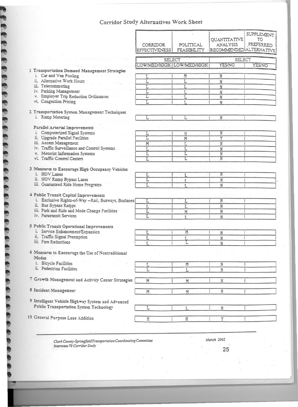
14 ` September 14, 2001 Scoping Meeting A Scoping Meeting was held on September 14, 2001, in the Springfield City Building Fourth Floor Conference Room. Leaders from communities along the corridor were invited, along with Ohio Department of Transportation Central Office and District Seven Office s planning staffs, FHWA Ohio Division (representing FHWA and FTA), and TCC. Discussion was led by Larry Himes, Transportation Director, TCC, Randy Chevalley, ODOT District 7 Planning Office and Libby Rushley, ODOT Central Office of Urban and Corridor Planning. Discussion centered on the finalization of the Major Investment Study. The preferred alternative for this study is the addition of a driving lane on those portions of the interstate which do not already have a six lane cross-section. The report will be submitted to the TCC for approval. Public Involvement and Public Outreach Summary ` Public meetings were held on October 5, 2000, April 5, 2001, and February 7, 2002, for the purpose of presenting the findings and recommendations of the study of the I-70 corridor. These meetings were attended by over 110 people. ` All of these meetings were held in the open house format which allowed participants to engage in open dialogue concerning the findings and recommendations of the Scoping Committee. ` The transportation stakeholders reached consensus on the preferred alternative after review of public comment and made recommendations that the MIS document be updated to reflect this decision. ALTERNATIVES Alternative strategies and services have been analyzed for their impact on the corridor. These analyses were presented to the scoping committee to assist in the decision-making process. These included the No Build Alternative, Travel Demand Management, Transportation Systems Management, High Occupancy Vehicle Facilities, Transit, and Transportation Network Improvements. A worksheet is included that was used at various points to assess the feasibility of some of the most likely transportation alternatives. Alternatives Analyses Discussions Each of the alternatives were explored as a possible remedy for the problem as follows: ` No Build ` Travel Demand Management (TDM) Rideshare Guaranteed Ride Home Park and Ride Facilities Compressed Work Week, Flexible Work Hours & Telecommuting 11
15 Nontraditional Transportation Modes ` Transportation Systems Management (TSM) Access Management Intelligent Transportation Systems (ITS) Traffic Control Measures High Occupancy Vehicle Lanes Transit Transportation Network Improvements ` General Purpose Through Lanes ` No Build The No Build alternative would involve retaining the existing four-lane roadway with no improvements other than routine maintenance. As discussed in the Existing Conditions section, some sections of I-70 in Clark County will be operating at LOS F. As traffic volumes continue to increase, congestion, travel time, and accident rates will also increase. Map 3 demonstrates the projected level of service for I-70 for the year 2025 (these are shown on the existing geometry of two lanes in each direction on I-70). Traffic volumes on I-70 are projected to surpass 70,000 Average Daily Traffic (ADT) for some segments by the year 2025, with truck volumes in excess of 15,300 per day, exceeding the I-70 design capacity. For these reasons, it has been determined that the No Build alternative is not desirable. ` Travel Demand Management (TDM) Alternatives to driving alone are being examined, on a more regular basis, to reduce congestion and improve mobility. The process of reducing the amount of vehicle travel is called Transportation Demand Management (TDM). TDM strategies encourage the use of alternatives to driving alone or changing the time of day of the trips. These strategies increase the awareness of the options that are available for making a trip. Most of the time personal vehicle travel is the only means considered for making a trip. Implementation of TDM strategies increase the options available for making a trip. Implementing TDM s may include the following actions: Assuring transit serves the person's residence and destination, whether a work trip, a shopping trip, or another type of trip; Informing persons of other people who live near them and work near them which might lead to ridesharing; Providing the opportunity to telecommute if one's job is adaptable to telecommuting; Instituting alternative or flexible work hours to make it more convenient to use transit, a rideshare arrangement or to travel during less congested hours; Providing and maintaining sidewalks and bicycle facilities for short trips. 12
16 Incentives or disincentives can be provided which encourage the switch from single occupant vehicle (SOV). These TDM strategies include parking fees, vehicle operating cost increases, or subsidies for using non-sov modes. If properly packaged, these incentives can benefit employers as well as the employees who choose to not use an SOV. TDM strategies focus primarily on reducing work travel. It is easiest to focus strategies on work trips because they are made at regular times of day and have consistent destinations. The peak congestion periods usually occur during the morning and afternoon work commute times. Approximately one-third of vehicle miles of travel (VMT) are the result of work trips. During peak periods, 50 percent or more of the traffic is work-commute travel. Focusing TDM strategies on work trips provides options for the single largest segment of travel and the travel that contributes over half of the peak-period congestion. Certain TDM strategies can also reduce other travel as well. Bicycle and pedestrian facilities as well as transit service serve more than just work trips. Rideshare As a part of our region's transportation planning program, the Rideshare Program cites a commitment to the national objectives of energy conservation, improved air quality, reduced traffic congestion and lower commuting costs. It offers a variety of programs and services including carpool and vanpool assistance, guaranteed ride home programs, transit authority general route and park-and-ride information, and employer programs and services. The program works with companies and organizations to promote ridesharing and provide services including computerized ridematching services, vanpool operations, organizing in-house rideshare campaigns and administering employee transportation surveys. Ridesharing promotions often target work shifts because the majority of traffic congestion, air quality, and safety problems occur during peak hour travel. While this TDM strategy may not target the study corridor specifically, carpools and vanpools may use the corridor. Historically, a successful rideshare program by itself will not provide sufficient relief from the current and projected congestion levels. However, a rideshare program can provide an effective supplement to a preferred alternative in relieving congestion levels. Guaranteed Ride Home One drawback of ridesharing or using transit is the possibility that a commuter will be stranded due to an emergency or an unplanned schedule change. This could 13
17 cause a person to miss the bus or his/her rideshare arrangement. A guaranteed ride home program raises the comfort level of ridesharers by providing transportation home should such a schedule change arise. The TCC administers a guaranteed ride home program. There is no cost to sign up for the program. The impacts of a Guaranteed Ride Home program on VMT are difficult to quantify. Guaranteed ride home works in conjunction with other ridesharing strategies to increase the effectiveness of the programs. Park and Ride Facilities Park and Ride facilities provide a location where motorists can park their vehicles to form carpools or vanpools. There are facilities within the corridor located at the SR 54 and SR72 interchanges. Compressed Work Weeks, Flexible Work Hours, and Telecommuting Flexible work hours, as well as staggered work hours and compressed work weeks could be initiated by employers with no other support. Flexible work hours provide the opportunity to alter individual starting and ending times to better match transit schedules or ridesharing arrangements. Staggered work hours alter the standard starting and ending times for all or groups of employees which allow the employees to make trips outside of the peak periods. Compressed work weeks lengthen the work day, shifting one or more of the trips outside of the peak period and reducing the number of trips per week the employee makes to work. These strategies have been implemented by Wright Patterson Air Force Base for many of their employees. Implementation of these strategies primarily shifts VMT from peak periods to off-peak periods. Therefore, total VMT per day is not significantly decreased. These strategies are best suited for areas with short peak periods. As the congested peak period becomes longer, it may not be possible to adjust work times enough so travel takes place during a less congested time. Telecommuting allows an employee to work from home, eliminating the need to make the trip to work. As with alternative work schedules, telecommuting's effectiveness depends on the number of employees eligible to telecommute. Nontraditional Transportation Modes Nontraditional Transportation Modes, such as bicycling and walking, are often overlooked as viable commuter alternatives in the United States. A regional bicycle transportation plan may serve as a tool to assist bicyclists, organizations, and 14
18 communities in bicycle facility planning. The plan should serve as a guide for future facility improvements for local jurisdictions. The plan should be consulted and bicycle facilities incorporated, when appropriate, during land development and roadway improvements. It should be the overall framework for a bikeway system that integrates and enhances the local and regional transportation systems. The plan should identify north-south and east-west corridors that serve the region and provide connectivity to transit, park-and-ride lots, major traffic generators, activity centers, and communities. The impact of bicycle facilities on corridor congestion is difficult to quantify and probably minimal. However, safe biking environments increase mobility for some segments of the population and provide another travel option for the corridor. When linked to transit facilities, improving bicycle facilities can further encourage transit use. To create a biking environment, it is not necessary to build bike paths and bike lanes throughout the corridor. Steps, however, should be taken to consider designs which facilitate bike use and provide locations to park bikes. Pedestrian facilities provide another option to trip makers. The choice to walk can be made for all trip purposes. Pedestrian facilities can also influence transit usage. At least one end of a transit trip includes a pedestrian trip. Without adequate pedestrian facilities to and from transit stops, transit will not be used. Pedestrian trips currently account for a small percentage of corridor trips. The impacts on corridor congestion and mobility through improvements to pedestrian facilities cannot be quantified. The expected impacts would be slight and would not eliminate the need to make the majority of the trips via motorized vehicles. These improvements encourage pedestrian trips, increase pedestrian safety and promote transit use. TDM strategies, such as alternative work hours, telecommuting, and parking management are employer-based. While these strategies may be further initiated at some future time by employers in the region, they are not expected to have significant impact on the corridor. The percentage of through and truck trips in the corridor suggests that employer-based TDM measures will not sufficiently reduce work trips enough to mitigate peak hour congestion through the corridor. Therefore, these strategies are not alternatives which solve the capacity problem in this corridor. ` Transportation Systems Management (TSM) The TDM strategies discussed earlier dealt with vehicle reduction measures. 15
19 Other operational improvement strategies include Transportation System Management (TSM) measures which relate to capacity enhancement. These TSM measures can range from relatively minor expenditures (with little or no construction) to those involving major expenditures and construction. There is a variety of options available which can be implemented in the corridor to increase capacity. Access Management, Intelligent Transportation Systems, and Traffic Control Measures are three such activities which are being promoted in the corridor. Access Management Access Management is a systematic process to maintain the safe, efficient use of a road while providing necessary and appropriate access to adjacent land. All roads are arranged in a hierarchy based on their function. Access levels are defined for the frequency, spacing, and type of access permitted and are adjusted for each class to maintain the desired traffic flow characteristics of capacity, operating speed, and safety. Higher classes, such as arterials, have stricter standards and policies to maintain greater mobility. Lower classes, such as collectors, have lower standards to permit greater access. Access management focuses on the service to be provided and brings together land use, transportation planning, design, and traffic engineering decisions as components of an integrated process to maintain that service. Studies across the country have highlighted the benefits of access management. Good access management practices can increase operating speeds, increase traffic carrying capacity, and reduce the accident rate on managed highways compared to an unmanaged facility. Even on highly congested urban arterials with high traffic volumes and poor levels of service, applying access management techniques can substantially increase the maximum daily traffic flow. Access management is an important planning consideration because of increasing traffic congestion, traffic safety issues, and the rising costs of road improvements. Good access management can: Reduce crashes and crash potential Preserve roadway capacity and the useful life of roads Decrease travel time and congestion Improve access to properties Coordinate land use and transportation decisions Improve air quality Maintain travel efficiency and related economic prosperity. 16
20 While an Access Management study has been conducted in the study area and techniques have been applied and will continue to be used to reduce and/or prevent congestion on parallel and cross routes, no additional techniques would have direct impact on preserving mobility and decreasing congestion on the Interstate itself. Intelligent Transportation Systems (ITS) The Intermodal Surface Transportation Efficiency Act of 1991 (ISTEA) provided for the establishment of the Intelligent Transportation System (ITS) program. ITS is the application of electronic, computer, and communications technology to vehicles and roadways to increase safety, reduce congestion, enhance mobility, minimize environmental impact, increase energy efficiency, and promote economic productivity for a healthier economy. Application of ITS technologies enables the existing physical transportation capacity to be used more efficiently and effectively. While many systems already in place have been operational for only a few years, there are indications that programs such as freeway management systems can increase safety by reducing accidents and minimize travel times by providing real-time information for travelers use. Freeway Management Systems (FMS) have been initiated in several Ohio cities, including Cincinnati and Columbus. Goals of this type of system include: optimize traffic flow through the roadway system detect and speed up the handling of traffic incidents provide motorists and the public with real time traffic information improve air quality by reducing recurrent congestion and decreasing the time to clear an incident. An important component of an FMS is incident management. Through the use of incident detection algorithms and video cameras, incidents can be identified and cleared in less time, thereby minimizing congestion due to the incident while improving overall safety. Traffic operating at a LOS C or D is less dense than LOS E or F and therefore able to recover quicker from incidents resulting in less congestion and delay on the freeway system. It is still too early in the evolution and adaptation of this technology to consider ITS as a viable single alternative to the congestion problems in this corridor. However, ITS should be included as an important component of a total congestion relief system for the region. 17
21 Traffic Control Measures Traffic control measures range from relatively low cost remedies requiring little or no construction to major projects which develop the maximum capacity of the surface street system. They include the following: Turning movement controls at intersections such as prohibition of left turns, provision of left-turn-only lanes, and the provision of left-turn signal phases on two-way streets. Turning movement controls at mid-block locations such as limiting the number of driveways, restricting certain driveways to right turns in and out, and requiring the provision of left- and right-turn lanes at driveways serving major traffic generators. Widening constricted sections of the roadway by applying the standards of the neighboring sections. Widening of intersection approaches to provide additional through or turning lanes. Elimination of offset (dog-leg) intersections to improve traffic movements and minimize signal clearance time. Provision of permanent physical channelization or barriers at intersections to ensure orderly traffic flow, and along roadways to restrict turning maneuvers. Upgrading signalization by replacing outmoded traffic signals with new, modern signal equipment to optimize signal efficiency and permit coordinated traffic-responsive signal progression. Reconstruction of at-grade intersections to permit widening, the installation of efficient turning lanes and channelization, and improvement of alignment. While these traffic control measures are useful for non-interstate applications, they will do little to provide a reasonable alternative for the I-70 corridor High Occupancy Vehicle Lanes High Occupancy Vehicle (HOV) lanes are highway lanes designed for the exclusive use of vehicles with more than one occupant. HOV lanes are defined as facilities to maximize person movement on roadways by increasing the average number of persons per vehicle. HOV lanes allow buses and carpools to bypass delay during congested periods, increasing the attractiveness of alternatives to traveling alone. These lanes are usually added to Interstate routes. HOV lanes may be restricted to buses only, two or more persons per vehicle, or three or more persons per vehicle. This is determined by the agencies involved in the HOV designation. 18
22 To attract HOV users, an HOV lane must provide at least a five to eight minute travel time savings. Any shift in travel from SOV to HOV would reduce total traffic, but in reality, not all eligible HOV s may use the HOV lane. Although HOV s would experience improved level of service within any one particular section, the majority of travelers would experience worse levels of service with an HOV lane than with adding a general purpose lane. While a more elaborate HOV configuration may draw more traffic, the costs would dramatically increase. For HOV operation to be more effective, a regional approach to the issue should be taken. Also, HOV lanes are most effective when they connect two major activity centers. These centers are currently not present. Therefore, an HOV facility would not divert a sufficient number of trips away from the existing lanes to achieve an acceptable solution. Transit The basic goal in examining the transit option is to reduce the number of single occupant vehicles and increase the level of service through a corridor. The latent demand for transit service in a corridor will dictate ridership much more so than the number of buses made available. Typically, transit accounts for a less than one percent mode split during the peak period in small urban areas. Typically, the number of people who will chose transit without some type of disincentive to driving alone, such as higher parking costs or limits on parking availability, is low. Transit will have little to no impact on the congestion in the corridor due to the number of through trips. Transportation Network Improvements It may be prudent to evaluate various surface street improvements considered or proposed within the study area by the Ohio Department of Transportation (ODOT) and county and local agencies and officials. The various projects can be analyzed, focusing on travel demand model results, environmental considerations, and costs. While these improvements will be locally significant, they will not alleviate the congestion on the interstate. ` General Purpose Through Lanes The addition of general purpose through lanes would reduce projected congestion by providing more highway capacity, reduce travel time, increase the level of service, and improve safety in the corridor. The lanes could be added in the existing right of way, which will limit the cost. This alternative alleviates a significant amount of congestion as shown in Tables 1 and 2. Of primary concern is the benefit to freight movement through the corridor. No other alternative addresses the needs of the 19
23 regional and national truck traffic which uses this corridor for the delivery of goods. The high percentage of through trips, for both cars and trucks, will be positively impacted by this alternative. This can therefore be considered a viable alternative. Interstate 70 Daily Traffic Counts (1998) Location Current lanes Total count Total per lane Cars Cars per lane Trucks Trucks per lane Total per lane with upgrade Cars per lane with upgrade Trucks per lane with upgrade ,770 9,128 38,460 6,410 16,310 2,718 9,128 6,410 2, ,390 11,232 49,640 8,273 17,750 2,958 11,232 8,273 2, ,350 11,838 30,870 7,718 16,480 4,120 7,892 5,145 2, ,080 12,520 33,520 8,380 16,560 4,140 8,347 5,587 2, ,380 13,345 36,870 9,218 16,510 4,128 8,897 6,145 2, ,460 10,865 27,820 6,955 15,640 3,910 7,243 4,637 2, ,710 9,928 24,610 6,153 15,100 3,775 6,618 4,102 2, ,250 10,313 26,090 6,523 15,160 3,790 6,875 4,348 2, ,440 10,360 26,290 6,573 15,150 3,788 6,907 4,382 2,525 Table 1 I-70 ADT Current & Future Configuration I Traffic Counts per Lane 16,000 14,000 12,000 10,000 8,000 6,000 4,000 2, Chart 2 total per lane with upgrade total per lane I-70: Current Traffic Counts per Lane/Existing & Future Configuration 20
24 Interstate 70 Projected 2025 ADT Location current # lanes 1998 total count 1998 total per lane 1998 total per lane with upgrade 2025 total count 2025 total per lane 2025 total per lane with upgrade ,770 9,128 9,128 78,321 13,054 13, ,390 11,232 11,232 96,368 16,061 16, ,350 11,838 7,892 67,711 16,928 11, ,080 12,520 8,347 71,614 17,904 11, ,380 13,345 8,897 76,333 19,083 12, ,460 10,865 7,243 62,148 15,537 10, ,710 9,928 6,618 56,785 14,196 9, ,250 10,313 6,875 58,988 14,747 9, ,440 10,360 6,907 59,259 14,815 9,877 Table 2 I-70 Current and Projected ADT I Traffic Counts per Lane 25,000 20,000 15,000 10,000 5,000 0 Chart total per lane total per lane with upgrade I-70: Projected Traffic Counts per Lane/Existing & Future Configuration 21
25 PREFERRED ALTERNATIVE The Preferred Alternative for the Interstate 70 Corridor has been determined to be the addition of General Purpose Through Lanes. ` After examining each alternative separately and the cumulative effects on service to the corridor of the lower cost alternatives, the preferred alternative was agreed to and subsequently proposed by the Scoping Committee. ` The preferred alternative and the rationale for it being proposed as the preferred alternative was based upon the most realistic estimate of benefits to the corridor over the next 25 years. ` Additional lanes are being planned in Montgomery and Madison counties. The reconstructed I-70/I-75 interchange in Montgomery County will impact the corridor through Clark County. ` Cost estimates for construction and maintenance of this alternative would allow the additional lanes to be phased over a 10 year period with a total cost of $61,514,000. The length of the proposed improvement would be miles. No additional right of way would be required to complete this project. I-70 Truck Counts 4,500 4,000 3,500 3,000 2,500 2,000 1,500 1, Chart trucks per lane trucks per lane with upgrade I-70 Trucks per Lane/ Current & Future Configuration 22
26 Additional Items for Further Study As a result of the Corridor Study, there were items which were determined to a have little impact on the operation of the interstate, but were still considered to be important to the area. 5 A new interchange at Burnett Road will require an Interchange Justification Study before any conclusions can made whether it is needed or not. Since this project would require a minimum of fifty percent, and possibly total local funding, the study will also need to determine if it will be cost effective. The study will need to be accomplished no later than 2004 to ensure adequate time for preparation in the event the interchange is found to be necessary to match with the timeline for the preferred alternative. 5 The US68/US40/SR4/Upper Valley Pike interchange/ intersection will require further study to find the best solution for the increasing congestion. 5 The extension of Leffel Lane to Dayton Road from its current terminus at Springfield-Xenia Road will need to be studied in conjunction with projected changes in land use. 5 Passive railroad crossings (3) need to be upgraded in the corridor. 5 A Corridor Management Plan for US40 is being undertaken as part of the Ohio National Road Scenic Byway. This plan will address many key issues in the parallel corridor, including a bikeway as a part of the National Road. Recommendations of the Plan will be evaluated for future implementation. 5 The ITS Early Deployment Plan was completed in Many recommendations are still undergoing development and study. These include the Motorist Information System and Incident Management. 5 A portion of the Access Management Plan will be implemented in Springfield on E. Main St. (US40) with coordinated signal system upgrades. These improvements to the parallel route will be undertaken in Impacts of the improvements will be further studied after completion. 23
27 Map 4 Interstate 70: Proposed Construction Schedule Interstate 70 Proposed Construction Schedule Legend Upgrade Year Current 2002 Miles Prepared by P.S. Holland Clark County-Springfield Transportation Study December 18, Clark County-Springfield Transportation Coordinating Committee March 2002
28
29 Sec Metropolitan transportation planning process: Major metropolitan transportation investments. (a) Where the need for a major metropolitan transportation investment is identified, and Federal funds are potentially involved, major investment (corridor or subarea) studies shall be undertaken to develop or refine the plan and lead to decisions by the MPO, in cooperation with participating agencies, on the design concept and scope of the investment. Where the studies have not been completed prior to plan approval, the provisions of Sec (b)(8) apply. (b) When any of the implementing agencies or the MPO wish to initiate a major investment study, a meeting will be convened to determine the extent of the analyses and agency roles in a cooperative process which involves the MPO, the State department of transportation, public transit operators, environmental, resource and permit agencies, local officials, the FHWA and the FTA and where appropriate community development agencies, major governmental housing bodies, and such other related agencies as may be impacted by the proposed scope of analysis. A reasonable opportunity, consistent with Sec (b)(1), shall be provided for citizens and interested parties including affected public agencies, representatives of transportation agency employees, and private providers of transportation to participate in the cooperative process. This cooperative process shall establish the range of alternatives to be studied, such as alternative modes and technologies (including intelligent vehicle and highway systems), general alignment, number of lanes, the degree of demand management, and operating characteristics. (c) To the extent appropriate as determined under paragraph (b) of this section, major investment studies shall evaluate the effectiveness and cost-effectiveness of alternative investments or strategies in attaining local, State and national goals and objectives. The analysis shall consider the direct and indirect costs of reasonable alternatives and such factors as mobility improvements; social, economic, and environmental effects; safety; operating efficiencies; land use and economic development; financing; and energy consumption. (d) These major investment studies will serve as the "alternatives analyses" required by section 3(i)(1)(A) of the Federal Transit Act (49 U.S.C. app. 1602(i)) for certain projects for which discretionary section 3 "New Start" funding is being sought. The studies will also be used as the primary source of information for the other section 3(i)(1)(A) Secretarial findings on cost-effectiveness, local financial commitment and capacity, mobility improvements, environmental benefits, economic development, operating efficiency, etc. (e) These major investment studies also will, when appropriate, serve as the analysis of demand reduction and operational management strategies pursuant to 23 CFR (b). 26
Appendix O Congestion Management Program REGIONAL TRANSPORTATION PLAN/SUSTAINABLE COMMUNITIES STRATEGY
 Appendix O Congestion Management Program REGIONAL TRANSPORTATION PLAN/SUSTAINABLE COMMUNITIES STRATEGY 2014 REGIONAL CONGESTION MANAGEMENT PROGRAM 2014 RTP/SCS APPENDIX O SAN JOAQUIN COUNCIL OF GOVERNMENTS
Corpus Christi Metropolitan Transportation Plan Fiscal Year Introduction:
 Introduction: Traffic congestion in the Corpus Christi Metropolitan area is not as much a function of population growth as the function of the increase in single occupant trips. Using census data, the
Congestion Management Process (CMP)
") Congestion Management Process (CMP) Introduction The Congestion Management Process (CMP) is a systematic, data-driven, and regionally accepted approach that aims to improve the performance of the transportation
Congestion Management Process (CMP) Introduction The Congestion Management Process (CMP) is a systematic, data-driven, and regionally accepted approach that aims to improve the performance of the transportation
Chapter 3 - Goals, Objectives, & Strategies
 Chapter 3 - This chapter presents goals, objectives, and strategies that have been developed as part of the Richmond Area MPO 2026 Long-Range Transportation Plan (LRTP) update. Strategies have been developed
10.0 Congestion Management Process
 Livability 2040 Regional Transportation Plan 10-1 10.0 Congestion Management Process 10.1 CMP Summary The identification and evaluation of projects for the Livability 2040 Regional Transportation Plan
Congestion Management Process 2013 Update
 OVERVIEW OF THE DALLAS-FORT WORTH CONGESTION MANAGEMENT PROCESS Traffic Congestion In The Dallas-Fort Worth Region With the Dallas-Fort Worth (DFW) urban area as its center, the North Central Texas region
EIGHT PLANNING FACTORS
 EIGHT PLANNING FACTORS Under the provisions of SAFETEA-LU, all Metropolitan Planning Organizations (MPOs) are required to consider eight (8) broad planning factors in the development of multi-modal transportation
Transportation Problems and Issues Excerpts from WWW Links
 Transportation Problems and Issues Excerpts from WWW Links Reference Bok, D. (2018). Transportation policy and planning. https://www.hks.harvard.edu/courses/transportation-policy-and-planning Transportation
MOTOR MPO CONGESTION MANAGEMENT PROCESS (CMP)
") MOTOR MPO CONGESTION MANAGEMENT PROCESS (CMP) Background: Metropolitan Planning Organizations that have been designated as a Transportation Management Area (TMA) are required to develop a Congestion Management
MOTOR MPO CONGESTION MANAGEMENT PROCESS (CMP) Background: Metropolitan Planning Organizations that have been designated as a Transportation Management Area (TMA) are required to develop a Congestion Management
Section 11: Transportation Strategies Toolbox
 Section 11: Transportation Strategies Toolbox A transportation strategies toolbox was developed to provide a systematic approach to identify potential strategies that address corridor transportation needs.
8: Transportation Demand &
 GPATS Long-Range Transportation Plan 8: Transportation Demand & Emerging Technologies INTRODUCTION The transportation systems of cities, states, and nations are undergoing a period of transformation. As
Proposed Comprehensive Update to the State of Rhode Island s Congestion Management Process
 Proposed Comprehensive Update to the State of Rhode Island s Statewide Planning Program January 2018 Summary Outline of of Action Steps 1. Develop Objectives for Congestion Management What is the desired
Appendix D: Functional Classification Criteria and Characteristics, and MnDOT Access Guidance
 APPENDICES Appendix D: Functional Classification Criteria and Characteristics, and MnDOT Access Guidance D.1 Functional classification identifies the role a highway or street plays in the transportation
Appendix D Functional Classification Criteria and Characteristics, and MnDOT Access Guidance
 Appendix D Functional Classification Criteria and Characteristics, and MnDOT Access Guidance Functional classification identifies the role a highway or street plays in the transportation system. Some highways
CONGESTION MANAGEMENT PROCESS (CMP) WEST MEMPHIS MPO
 WEST MEMPHIS MPO") CONGESTION MANAGEMENT PROCESS (CMP) WEST MEMPHIS MPO INTRODUCTION This policy document of the West Memphis Metropolitan Planning Organization (MPO) provides the framework to carryout the CMP in the West
CONGESTION MANAGEMENT PROCESS (CMP) WEST MEMPHIS MPO INTRODUCTION This policy document of the West Memphis Metropolitan Planning Organization (MPO) provides the framework to carryout the CMP in the West
Final Congestion Management Process
 Final Congestion Management Process 2015 Prepared by Tulare County Association of Governments 210 N. Church St., Suite B Visalia, California 93291 1. Introduction: What Is Congestion? Congestion can generally
EXECUTIVE SUMMARY REGIONAL TRANSPORTATION PLAN 2050
 EXECUTIVE SUMMARY REGIONAL TRANSPORTATION PLAN 2050 Introduction Goals Policies, and Performance Measures Growth Forecast and Planned Land Use Development Key Recommendations i Executive Summary April
CITY OF JACKSONVILLE 2030 MOBILITY PLAN STUDY UPDATE GOALS, OBJECTIVES, AND PERFORMANCE MEASURES PREPARED FOR: CITY OF JACKSONVILLE
 CITY OF JACKSONVILLE 2030 MOBILITY PLAN STUDY UPDATE GOALS, OBJECTIVES, AND PERFORMANCE MEASURES 3.20.2017 PREPARED FOR: CITY OF JACKSONVILLE 55 Railroad Row White River Junction, VT 05001 802.295.4999
EXAMPLES OF COMPREHENSIVE PLAN POLICIES HOW TO ESTIMATE THE BENEFITS OF THE CTR PROGRAM
 TABLE OF CONTENTS INTRODUCTION... I BACKGROUND OF THE COMMUTE TRIP REDUCTION EFFICIENCY ACT... II MAKING THE CONNECTION BETWEEN COMMUTE TRIP REDUCTION AND THE GROWTH MANAGEMENT ACT... IV CTR PLANNING AND
Summary of transportation-related goals and objectives from existing regional plans
 SMTC 2050 Long Range Transportation Plan Appendix A: Summary of transportation-related goals and objectives from existing regional plans SMTC 2050 Long Range Transportation Plan Summary of transportation-related
CHAPTER 8 TRANSPORTATION ELEMENT
 CHAPTER 8 TRANSPORTATION ELEMENT Section 8.01 Purpose: The purpose of this Chapter (element) is to establish the desired and projected transportation system within Niceville and to plan for future motorized
MARC Congestion Management Process Policy
 MARC Congestion Management Process Policy Adopted by the MARC Board of Directors on May 24, 2011 Background Traffic congestion can be generally defined as a condition where the volume of users on a transportation
6.0 CONGESTION HOT SPOT PROBLEM AND IMPROVEMENT TRAVEL DEMAND MODEL ANALYSIS
 6.0 CONGESTION HOT SPOT PROBLEM AND IMPROVEMENT TRAVEL DEMAND MODEL ANALYSIS 6.1 MODEL RUN SUMMARY NOTEBOOK The Model Run Summary Notebook (under separate cover) provides documentation of the multiple
Congestion Management Process Update
 report Congestion Management Process Update prepared for Houston-Galveston Area Council prepared by Cambridge Systematics, Inc. 10415 Morado Circle, Building II, Suite 340 Austin, TX 78759 with Alliance
FLORIDA DEPARTMENT OF TRANSPORTATION PROCEDURE DEVELOPMENT OF THE
 FLORIDA DEPARTMENT OF TRANSPORTATION PROCEDURE DEVELOPMENT OF THE FLORIDA INTRASTATE HIGHWAY SYSTEM Topic No.: 525-030-250-f Office: Systems Planning Effective Date: May 16, 2002 DEVELOPMENT OF THE FLORIDA
Rapid City Area Metropolitan Planning Organization OPERATIONS PLAN
 Rapid City Area Metropolitan Planning Organization OPERATIONS PLAN Prepared for the Rapid City Area Metropolitan Planning Organization Endorsed by the Executive Policy Committee of the Rapid City Area
KAW CONNECTS EXECUTIVE SUMMARY
 Executive Summary Page E-1 Introduction KAW CONNECTS EXECUTIVE SUMMARY The Kansas Department of Transportation (KDOT) and the Kansas Turnpike Authority (KTA) have both recognized the need to plan for the
Performance Measures for Transportation Planning Part 1
 Performance Measures for Transportation Planning Part 1 Flint, MI July 12, 2011 Brian Betlyon FHWA Resource Center Overview Performance Measurement in Transportation Planning Module Outcomes Describe performance
Executive Summary. Study Background
 Executive Summary ES 1.1 Introduction The Capitol Region Council of Governments (CRCOG) and the Connecticut Department of Transportation (CTDOT) initiated the (BTS) in 2006 to identify near and long-term
12 Evaluation of Alternatives
 12 Evaluation of Alternatives This chapter evaluates the effectiveness of the No-Build Alternative and the proposed METRO Blue Line Light Rail Transit (BLRT) Extension project based on the information
7.0 TRANSPORTATION MANAGEMENT
 7.0 TRANSPORTATION MANAGEMENT I. Introduction/Current State of Transportation Management in KC Region The Kansas City region has invested considerable effort and resources in the design and implementation
ATTACHMENT A. Detailed Study Scope. I-66 (Inside) Multi-modal Study Scope
 Multi-modal Study Scope") ATTACHMENT A Detailed Study Scope I-66 (Inside) Multi-modal Study Scope EXECUTIVE SUMMARY The Virginia Department of Transportation (VDOT) seeks consultant assistance in identifying and evaluating a range
ATTACHMENT A Detailed Study Scope I-66 (Inside) Multi-modal Study Scope EXECUTIVE SUMMARY The Virginia Department of Transportation (VDOT) seeks consultant assistance in identifying and evaluating a range
Report of the Results and Recommendations To the County Executive and County Board. From SOUTHWEST DANE TRANSPORTATION ADVISORY COMMITTEE
 Report of the Results and Recommendations To the County Executive and County Board From SOUTHWEST DANE TRANSPORTATION ADVISORY COMMITTEE Chair: Norbert Scribner, Representing the Villages Secretary: Michael
INDIANA S INTERMODAL MANAGEMENT SYSTEM Stephen C. Smith Planning Manager, Transportation Planning Division Indiana Department of Transportation
 96 INDIANA S INTERMODAL MANAGEMENT SYSTEM Stephen C. Smith Planning Manager, Transportation Planning Division Indiana Department of Transportation Indiana is in the process of developing an Intermodal
Draft Alternatives and Screening Criteria
 Draft Alternatives and Screening Criteria 1 *Reasonable Alternatives 1. Initial Screening Use a series of yes/no questions to determine what alternatives are reasonable. Viable Alternatives 2. Quantitative
RESOLUTION NO
 RESOLUTION NO. 2018-12 RESOLUTION OF THE SOUTHEASTERN WISCONSIN REGIONAL PLANNING COMMISSION AMENDING THE TRANSPORTATION IMPROVEMENT PROGRAM FOR SOUTHEASTERN WISCONSIN: 2017-2020 WHEREAS, the Southeastern
APPENDIX A: Transportation Planning Rule
 A APPENDIX A: Transportation Planning Rule This appendix contains the full text of Oregon s Transportation Planning Rule (TPR). Transportation Planning Rule (TPR) NOTE: The official copy of an Oregon Administrative
1 I N T R O D U C T I O N
 THE 2040 OKI REGIONAL TRANSPORTATION PLAN This is the metropolitan transportation plan for the Ohio-Kentucky-Indiana Regional Council of Governments (OKI). OKI is the federally designated regional transportation
GUIDING PRINCIPLES MEMORANDUM
 M E T R O P O L I TAN TRA NS P O RTATI O N PLAN GUIDING PRINCIPLES MEMORANDUM El Paso Metropolitan Planning Organization INTRODUCTION The guiding principles for development of the El Paso MPO s Destino
Addendum #3 to the Regional Transportation Plan
 Nashville Area Metropolitan Planning Organization Addendum #3 to the Regional Transportation Plan Effective November 21, 2018 Nashville Area Metropolitan Planning Organization 138 Second Avenue North Nashville,
The Role of Transportation Systems Management & Operations in Supporting Livability and Sustainability
 The Role of Transportation Systems Management & Operations in Supporting Livability and Sustainability Michael Grant, ICF International February 7, 2012 NTOC Webinar Highlights of FHWA/FTA Primer Background:
1 INTRODUCTION 1-1 CTPS
 1 INTRODUCTION This report of the Congestion Management System (CMS) for the Boston Region Metropolitan Planning Organization (MPO) documents the region s mobility concerns. (The region is shown in Figure
Association for Commuter Transportation Recommendations to USDOT on MAP-21 Performance Measures
 Association for Commuter Transportation 1341 G Street, NW, 10th Floor Washington, DC 20005 Tel: 202.719.5331 www.actweb.org Association for Commuter Transportation Recommendations to USDOT on MAP-21 Performance
The Policies section will also provide guidance and short range policies in order to accomplish the goals and objectives.
 4 Goals & Objectives INTRODUCTION The 2015-2040 MTP preserves and promotes the quality of life and economic prosperity of the MAB by providing a transportation system consistent with the regional goals.
Contents i Contents Page 1 A New Transportation Plan Community Involvement Goals and Objectives... 11
 Contents i Contents 1 A New Transportation Plan... 1 Why develop a new plan?... 1 What area does the LRTP focus on?... 2 Why is this LRTP important?... 3 Meeting Requirements for Transportation Planning...
Town of Lexington Planning Board
 Town of Lexington Planning Board TRANSPORTATION DEMAND MANAGEMENT POLICY Adopted by Vote of the Board, September 16, 1998 Originally Adopted March 10, 1997 OBJECTIVES: This Policy focuses on meeting the
Mobility and System Reliability Goal
 Mobility and System Reliability Goal Provide surface transportation infrastructure and services that will advance the efficient and reliable movement of people and goods throughout the state. Background:
1RUWKZHVW#:LFKLWD 0DMRU#,QYHVWPHQW#6WXG\
 1RUWKZHVW#:LFKLWD 0DMRU#,QYHVWPHQW#6WXG\ Executive Summary 3UHSDUHGýIRUã 3UHSDUHGýE\ã.DQVDVý'HSDUWPHQWýRI 7UDQVSRUWDWLRQ,QýDVVRFLDWLRQýZLWKã (DUWKý7HFKý,QFï EXECUTIVE SUMMARY Introduction This Northwest
Los Angeles County Congestion Reduction Demonstration Project
 Los Angeles County Congestion Reduction Demonstration Project frequently asked questions update #1 /august 2008 Los Angeles County Metropolitan Transportation Authority (Metro), California Department of
Going Forward The Plan to Maintain & Improve Mobility Frequently Asked Questions (FAQs)
") Going Forward The Plan to Maintain & Improve Mobility Frequently Asked Questions (FAQs) What is Going Forward The Plan to Maintain & Improve Mobility (Plan) and why does the region need a Long Range Transportation
Going Forward The Plan to Maintain & Improve Mobility Frequently Asked Questions (FAQs) What is Going Forward The Plan to Maintain & Improve Mobility (Plan) and why does the region need a Long Range Transportation
Rapid City Area Metropolitan Planning Organization OPERATIONS PLAN
 Rapid City Area Metropolitan Planning Organization OPERATIONS PLAN Prepared for the Rapid City Area Metropolitan Planning Organization Endorsed by the Executive Policy Committee of the Rapid City Area
Chapter #9 TRAVEL DEMAND MODEL
 Chapter #9 TRAVEL DEMAND MODEL TABLE OF CONTENTS 9.0 Travel Demand Model...9-1 9.1 Introduction...9-1 9.2 Overview...9-1 9.2.1 Study Area...9-1 9.2.2 Travel Demand Modeling Process...9-3 9.3 The Memphis
Demand Reduction Assumptions Used For Travel Demand Analysis of EIS Alternatives
 M E M O R A N D U M Demand Reduction Assumptions Used For Travel Demand Analysis of EIS Alternatives TO: FROM: Project Management Team Steve Perone/PTV America DATE: Revised: February 6, 2009 Background
Technical Report 4: Congestion Management Process. Final Adopted Plan January 2016
 Long Range Transportation Plan Technical Report : Congestion Management Process Final Adopted Plan January South Orange Avenue, Suite, Orlando, FL -- www.metroplanorlando.com MetroPlan Orlando @metroplan_orl
CLA /10.54, PID Project Description:
 Project Description: The proposed project will consist of widening IR 70 to three lanes from Enon Road (SLM 06.75) to the US 68 interchange ramps (SLM 10.55). IR 70 is a component of the Strategic Highway
14.0 TRANSPORTATION PLANNING RULE COMPLIANCE
 14.0 TRANSPORTATION PLANNING RULE COMPLIANCE As stated earlier in this plan, the Oregon Department of Land Conservation and Development (DLCD), with concurrence from ODOT, adopted Transportation Planning
TMACOG Expressway Needs Study/ Major Investment Study (MIS) Executive Summary. Table of Contents. I Introduction 1
 Executive Summary. Table of Contents. I Introduction 1") TMACOG Expressway Needs Study/ Major Investment Study (MIS) Executive Summary Table of Contents Page I Introduction 1 II Study Area and Problem Statement 1 III Study Process 8 IV Needs Assessment 9 V Coordination
TMACOG Expressway Needs Study/ Major Investment Study (MIS) Executive Summary Table of Contents Page I Introduction 1 II Study Area and Problem Statement 1 III Study Process 8 IV Needs Assessment 9 V Coordination
Technical Briefing Report
 Technical Briefing Report March 2007 CONGESTION MANAGEMENT PROCESS (CMP) The Congestion Management Process (CMP) seeks a management solution to a growing traffic problem by targeting resources to operational
2030 Transportation Policy Plan SUMMARY PRESENTATION. Land Use Advisory Committee November 15, 2012
 2030 Transportation Policy Plan SUMMARY PRESENTATION Land Use Advisory Committee November 15, 2012 Today s Topics Transportation Policy Plan (TPP) Requirements and Background Current TPP Policies, Issues
Transportation and Utilities
 4 Section 4 Transportation and Utilities 4.0 Introduction Transportation and utility systems are essential to accommodate and support development proposed in the Future Land Use Map. The following pages
AIR QUALITY AND CLIMATE CHANGE EVALUATION GUIDANCE
 AIR QUALITY AND CLIMATE CHANGE EVALUATION GUIDANCE The following guidance provides additional details regarding the process followed by PSRC to evaluate projects for potential air quality benefits. As
Pasco County MPO: Congestion Management Process PROCEDURES HANDBOOK
 : Congestion Management Process PROCEDURES HANDBOOK Final: March 2016 TABLE OF CONTENTS CONGESTION MANAGEMENT PROCEDURES HANDBOOK OVERVIEW... i Chapter 1: INTRODUCTION... 1-1 Causes of Congestion... 1-2
Congestion Management Process 2013 Update
 Congestion Management Process 2013 Update TRAVEL DEMAND MANAGEMENT AND TRANSPORTATION SYSTEM MANAGEMENT AND OPERATIONS STRATEGIES AND PROJECTS TDM and TSM&O Strategies Commuter Transportation Options Associated
ELEMENT M GROWTH MANAGEMENT
 Growth Management ELEMENT M GROWTH MANAGEMENT GOAL: To ensure that growth and development are integrally planned with, and phased concurrently with, the City of Irvine s ability to provide an adequate
CHAPTER 2. VISION, GOALS AND MTP FRAMEWORK
 CHAPTER 2. VISION, GOALS AND MTP FRAMEWORK MTP VISION In order to create a framework for the 2040 Metropolitan Transportation Plan (MTP), a vision statement was drafted by the Vision/Goals Committee and
Chapter 2 Transportation Element Goals, Objectives and Policies
 Chapter 2 Transportation Element Goals, Objectives and Policies City of Belleview Comprehensive Plan Adopted by Ord 2016-10 on July 5, 2016 GOALS, OBJECTIVES AND POLICIES Goal 2 Transportation...1 Objective
MONITORING IMPLEMENTATION AND PERFORMANCE
 12 MONITORING IMPLEMENTATION AND PERFORMANCE The FAST Act continues the legislation authorized under MAP-21, which created a data-driven, performance-based multimodal program to address the many challenges
Memorandum. FROM: Jim Ortbal Rosalynn Hughey Barry Ng TO: HONORABLE MAYOR, CITY COUNCIL. DATE: June 16, 2017
 CITY OF SANjOSE CAPITAL OF SILICON VALLEY TO: HONORABLE MAYOR, CITY COUNCIL SUBJECT: TRANSPORTATION POLICY UPDATE REQUIRED BY STATE LAW - LOS TO VMT Memorandum FROM: Jim Ortbal Rosalynn Hughey Barry Ng
North Central Texas Council of Governments. Workshop TxDOT Dallas
 Workshop TxDOT Dallas July 10, 2015 1 CMP Workshop Overview Overview of the CMP CMP and Documentation Project Implementation Form CMP Corridor Analysis Fact Sheet CMP Roadway Deficiency Form Project Examples
APPENDIX A - PLANS AND POLICY REVIEW FEBRUARY 2017
 APPENDIX A - PLANS AND POLICY REVIEW FEBRUARY 2017 DENVERMOVES Transit Denver Moves: Transit APPENDIX A PLANS AND POLICY REVIEW 2035 Metro Vision Regional Transportation Plan (MVRTP) (2011) 2040 Fiscally
SCS Scenario Planning
 E SCS Scenario Planning Introduction As part of the 2035 MTP/SCS process, AMBAG developed a series of land use and transportation alternative scenarios for evaluation and testing to demonstrate how the
MOBILITY AND ALTERNATIVES ANALYSIS
 6 MOBILITY AND ALTERNATIVES ANALYSIS BACK OF SECTION DIVIDER 6.0 Mobility and Alternatives Analysis Travel demand analysis provides a framework for the identification of transportation facilities and services
OKI Congestion Management System Analysis. Data Collection Report Year 1
 OKI Congestion Management System Analysis Data Collection Report Year 1 May 2002 Prepared by the Ohio-Kentucky-Indiana Regional Council of Governments Acknowledgments Title OKI Congestion Management System
Contents. Introduction 1
 Contents Introduction 1 Pg. 01 Traffic congestion impacts how easy - or not - it is to get around. While traffic will grow as more people and jobs move to the Alamo Area, we can and should try to manage
2. Goals and Objectives
 Pedestrians in Charlotte s busy Uptown. CRTPO Mission The mission of the Charlotte Regional Transportation Planning Organization (CRTPO) is to plan for transportation options that ensure mobility, respect
2. Guiding Principles, Objectives, and Policies
 2. Guiding Principles, Objectives, and Policies INTRODUCTION The guiding principles for the 2040 MTP Update establish the vision and key focus areas for this planning effort. They combine the guidance
TCATS October 12-Michigan Works 5:30-7pm. NATS October 19-Niles District Library 6-7:30pm
 Goal Development Workshop TCATS October 12- Works 5:30-7pm NATS October 19-Niles District Library 6-7:30pm SAFETEA-LU Goals 2035 TwinCATS Goals 2030 TwinCATS Goals 1. Support the economic vitality of the
SECTION II CONTROLLED ACCESS FACILITIES
 SECTION II CONTROLLED ACCESS FACILITIES SYSTEM IDENTIFICATION A critical component of the Dallas-Fort Worth (DFW) Metropolitan Transportation System is the regional freeway and tollway systems, which are
Appendix B. OKI 2030 Regional Transportation Plan Project Scoring Process. Ohio Kentucky Indiana Regional Council of Governments
 Appendix B OKI 2030 Regional Transportation Plan Project Scoring Process APPENDIX B OKI 2030 REGIONAL TRANSPORTATION PLAN PROJECT SCORING PROCESS Background This scoring process is intended to assist selection
Level of Service (LOS) Improvements for Deficiency Plans
 Improvements for Deficiency Plans") Level of Service (LOS) Improvements for Deficiency Plans implemented to improve LOS. The projects listed in the Tool Box represent only a partial list of possible improvements. Project sponsors should
Level of Service (LOS) Improvements for Deficiency Plans implemented to improve LOS. The projects listed in the Tool Box represent only a partial list of possible improvements. Project sponsors should
VTrans2040 Multimodal Transportation Plan Corridors of Statewide Significance Needs Assessment Western Mountain Corridor (L)
") VTrans2040 Multimodal Transportation Plan Corridors of Statewide Significance Needs Assessment Western Mountain Corridor (L) 77 Table of Contents I. Corridor Overview Land Use and Demographics Corridor
VTrans2040 Multimodal Transportation Plan Corridors of Statewide Significance Needs Assessment Western Mountain Corridor (L) 77 Table of Contents I. Corridor Overview Land Use and Demographics Corridor
PINELLAS COUNTY MOBILITY PLAN SUMMARY REPORT
 PINELLAS COUNTY MOBILITY PLAN SUMMARY REPORT In September, 2013, the Pinellas County Mobility Plan Report was approved by the Metropolitan Planning Organization (MPO). This action endorsed a countywide
Chapter 2 Transportation Policy Plan Strategies
 Chapter 2 Transportation Policy Plan Strategies As discussed in Chapter 1, the current federal transportation law, Fixing America s Surface Transportation Act (FAST Act), mandates a streamlined and performance-based
Houston Galveston Area Council Congestion Management Process
 Houston Galveston Area Council Congestion Management Process APPENDIX G of the 2035 Regional Transportation Plan Update Prepared for: Houston-Galveston Area Council Transportation Department 3555 Timmons
4: Transportation and Land Use
 Chapter Figure 4-1: Recent development has brought more housing and mixed use Downtown Minneapolis - looking north from E 15th Street at the Grant Street / 11th Street exit 4: Transportation and Land Use
Evaluation of Alternatives
 Chapter 9.0 Evaluation of Alternatives Chapter 9.0 provides a summary evaluation of the No Build Alternative and the Preferred Alternative. The evaluation contained within this chapter is an assessment
September Public Meetings. Developing a Blueprint for the Corridor
 September Public Meetings Developing a Blueprint for the Corridor Study Background Study initiated by the Commonwealth Transportation Board (CTB) and administered by VDOT in association with VDRPT. Addresses
ACTIVE TRANSPORTATION ADVISORY COMMITTEE. Memphis MPO March 30, 2015
 ACTIVE TRANSPORTATION ADVISORY COMMITTEE Memphis MPO March 30, 2015 Agenda Welcome & Introductions Announcements and Briefings Livability 2040: Regional Transportation Plan Congestion Management Process
GUIDE FOR THE PREPARATION OF TRAFFIC IMPACT STUDIES
 GUIDE FOR THE PREPARATION OF TRAFFIC IMPACT STUDIES Adopted by Town Council on November 25, 2008 Prepared By: HNTB Engineering Department Planning Department TABLE OF CONTENTS I. INTRODUCTION... 1 II.
PROJECT SUBMISSION FORM
 PROJECT SUBMISSION FORM Basic Project Information CEID 1182 1. Submitting Agency: MDOT/State Highway Administration 2. Secondary Agency: 3. Agency Project ID: 4. Project Type: Interstate Primary Secondary
TRANSPORTATION RELATIONSHIP TO OTHER ELEMENTS OF THE PLAN AND COUNTY REGULATIONS VISION FOR TRANSPORTATION PLANNING ROAD NETWORK SECTION 7
 TRANSPORTATION Like many growing western counties, Douglas County focuses on one of the most integral elements in land-use planning: transportation. The primary purpose of a transportation network is to
Final Environmental Impact Statement and Section 4(f) Evaluation
 Evaluation") Glossary The following glossary defines common transit terminology, adapted from the American Public Transit Association Glossary of Transit inology (1994). Accessibility Alternative Fuels A.M. Peak Base
Glossary The following glossary defines common transit terminology, adapted from the American Public Transit Association Glossary of Transit inology (1994). Accessibility Alternative Fuels A.M. Peak Base
Performance Measures Workshop, May 18, 2017
 Measuring What Matters: Above and Beyond Requirements Performance Measures Workshop, May 18, 2017 Presentation Overview Background - origin and evolution of the Regional Outcomes Framework. Regional Outcomes
PROPOSED AMENDMENT OF THE I 76 INTEGRATED CORRIDOR MANAGEMENT PROJECT TO THE CONNECTIONS 2040 PLAN FOR GREATER PHILADELPHIA
 PROPOSED AMENDMENT OF THE I 76 INTEGRATED CORRIDOR MANAGEMENT PROJECT TO THE CONNECTIONS 2040 PLAN FOR GREATER PHILADELPHIA Background and Project Description In July 2013, the Delaware Valley Regional
Appendix A: Project Planning and Development A-1 White Paper on Transit and the Tappan Zee Hudson River Crossing Project
 Appendix A: Project Planning and Development A-1 White Paper on Transit and the Tappan Zee Hudson River Crossing Project Purpose of White Paper White Paper on Transit and the Tappan Zee Hudson River Crossing
SECTION III - REGIONAL ARTERIAL SYSTEM. The Regional Arterial System is a subcomponent of a broader regional thoroughfare system.
 SECTION III - REGIONAL ARTERIAL SYSTEM SYSTEM IDENTIFICATION The Regional Arterial System is a subcomponent of a broader regional thoroughfare system. The NCTCOG Regional Thoroughfare Plan (RTP) recognizes
CITY OF VALLEJO PUBLIC WORKS DEPARTMENT TRAFFIC IMPACT Analysis/Study GUIDELINES
 The City Engineer, under the authority of the Public Works Director and recommendations from the Traffic Engineer, will make the final decision on the need for a traffic study. The purpose of the traffic
Congestion Management Process in the US A Federal Requirement
 Congestion Management Process in the US A Federal Requirement ITS Argentina November 6, 2013 U.S. Department of Transportation Federal Highway Administration Outline of Seminar Discussion of Congestion
Chapter 5 Transportation Draft
 Chapter 5 Transportation Draft Discussion Similar to the other elements in the Comprehensive Plan, the transportation element impacts the quality of life, economic development and public safety of the
CHAPTER 2 PURPOSE AND NEED
 CHAPTER 2 PURPOSE AND NEED Chapter 2 SH 121 IH 30 to FM 1187 2.0 PURPOSE AND NEED 2.1. for the Project Continued growth and urbanization in the DFW region has resulted in the need for more efficient transportation