Welcome to the Public Information Centre. Red Hill Business Park South Transportation Master Plan Addendum. June 25, :00 p.m. to 8:00 p.m.
|
|
|
- Corey Foster
- 6 years ago
- Views:
Transcription
1 Welcome Welcome to the Transportation Master Plan Addendum June 25, :00 p.m. to 8:00 p.m. Please sign-in

2 Background In 2006 the City of Hamilton completed the North Glanbrook Industrial Business Park (NGIBP) Transportation Master Plan and identified the following preferred transportation network: 2006 NGIBP Transportation Master Plan Preferred Transportation Network The NGIBP is now known as the Red Hill Business Park South.
3 Background and Study Area Following the completion of the NGIBP TMP, a Class Environmental Assessment (Class EA) was completed and identified the Trinity Church Arterial Road Corridor (see map below). That corridor is now part of the approved transportation network within the Red Hill Business Park South. Study Area
4 Problem/Opportunity Within the the development of the lands south of Twenty Road between the future Dartnall Road Extension and Glover Road changes the opportunities for developing the major road network as originally planned. The form of the industrial development occurring within the Red Hill Business Park South, formerly the North Glanbrook Industrial Business Park (NGIBP), warrants a review of the: The alignment of Twenty Road as identified in the NGIBP Transportation Master Plan (TMP); and The location of the intersection of the future Trinity Church Arterial Road Corridor with Twenty Road. The review is required to address changes to transportation assumptions and requirements since the original 2006 NGIBP TMP.

5 Class EA Process This study is being completed in accordance with the Municipal Class Environmental Assessment (Municipal Engineers Association, October 2000, as amended in 2007 & 2011). We Are Here
6 Class EA Requirements This study is being planned as an Addendum under the Municipal Class EA. The will: fulfill the Phases 1 and 2 Class EA requirements of any Schedule B projects that are identified; and outline additional work that will be required to implement any Schedule C projects that are identified as part of the study.
7 Review of the NGIBP TMP The intent of the review is to ensure that the current planned road network in conjunction with a review of Twenty Road and its intersection with the future Trinity Church Arterial Road Corridor extension will meet transportation needs and be in keeping with ongoing and anticipated development within the business park. Based on recent developments within the RHBPS, there appears to be market demand for larger parcels of industrial land. As a result, the road network within the business park should provide the flexibility for larger development.
8 Review of the NGIBP TMP Property owners on Glover Road, north of Dickenson Road, have expressed a concern of potential additional through traffic within the residential area as a result of the developments in the business park. The feedback from local residents has identified the need to review the function of Glover Road as it transitions from the industrial area into the rural residential area north of Dickenson Road East. Options will be evaluated to address concerns expressed by the local residents.

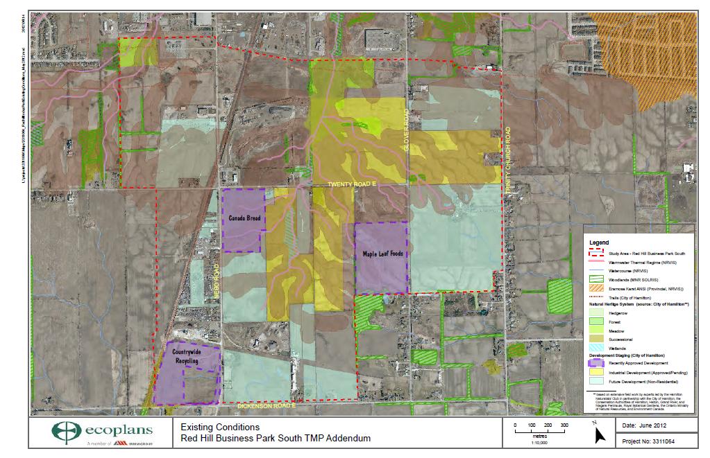
9 Existing Conditions
10 Traffic Analysis As part of the review of the transportation network, a traffic analysis has been completed to reflect recent development planning and road network refinements since The traffic analysis has determined that: no additional road capacity (e.g. additional lanes) will be required beyond the existing and approved road network; and one east-west collector road (e.g. Twenty Road) would be sufficient to accommodate traffic through the business park.
11 Alternatives Twenty Road Twenty Road: Alternative 1 Alignment as recommended in the NGIBP TMP Alignment of Twenty Road to swing to the north between the future Dartnall Road Extension and Glover Road and then continue on a straight line to connect with the Trinity Church Arterial Road Corridor.
12 Alternatives Twenty Road Twenty Road: Alternative 2 Extend existing road allowance directly east to the future Trinity Church Arterial Road Corridor Alignment of Twenty Road to extend directly east from the existing right-of-way and intersect with a southerly extension of the Trinity Church Arterial Road Corridor. This alignment was previously considered as part of Alternatives 2 and 4 in the NGIBP TMP.
13 Evaluation Twenty Road Twenty Road Summary of the Evaluation of Alternatives and Selection of a Preferred Alternative Natural Social Factors Alternative 1 Alignment as recommended in the NGIBP TMP Alternative 2 Extend existing road allowance directly east to the future Trinity Church Arterial Road Corridor Summary Notes Alternative 1 is slightly preferred from a terrestrial perspective. Alternative 2 is slightly preferred from an aquatic perspective. There is no discernible difference in terms of potential impacts to species at risk without field work to assess habitat potential and confirm presence of certain species (i.e. Bobolink, Eastern Meadowlark, Barn Swallow); however, the alignment traverses wheat and corn fields which are generally low quality habitat for these species. Alternatives 1 and 2 result in the similar potential effects to residential areas due to traffic and traffic related nuisance effects (e.g. noise). Economic Alternative 2 is preferred as it provides more opportunity for desirable larger potential lots for future development and is most consistent with existing approved plans. Cultural Alternatives 1 and 2 result in similar potential effects as both impact lands with archaeological potential. Transportation and Utilities Overall Summary Legend Most Preferred Alternatives 1 and 2 result in similar effects to the overall road network and have similar construction costs. Traffic demand can be accommodated on one east-west collector road (i.e. Twenty Road). Compared to the previously approved network, there is an overall cost savings ($2.2M[rural] - $2.8M [urban]) associated with only constructing one east-west collector road. Alternatives 1 and 2 result in similar impacts to the natural, social and cultural environments as well as to transportation and utilities. Alternative 2 is preferred as it results in the least adverse impacts to the economic environment by providing more opportunity for desirable larger potential lots for future development and by being most consistent with existing approved plans. Least Preferred Looking for more detail? The detailed evaluation table is available for review please see the binders on the tables.
14 Preferred Alternative Twenty Road Based on the evaluation of alternatives, Alternative 2 is the preferred alternative: Twenty Road - Preferred Alternative - Intersection Configuration Subject to Detail Design
15 Glover Road - Traffic Glover Road will transition from the industrial area (with curb and gutter) into the rural residential area (with gravel shoulders and ditches) and with its reconstruction through the industrial area the pavement will narrow slightly as it changes from an urban to a rural cross section. Residents have expressed concern regarding potential traffic related impacts associated with the development of the business park. The following table provides peak travel time traffic volumes along Glover Road: Glover Road Two-Way Traffic North of Dickenson Road AM Peak PM Peak Existing without business park development with business park development Total Incremental Traffic Growth Business Park Traffic Growth The following table provides 24 hour volumes along Glover Road: Glover Road 24 Hour Volumes North of Dickenson Road Existing Estimated ,000 Collector roads like Glover Road typically carry between 5000 to 8000 vehicles per day, therefore in the future traffic volumes would be considered low for this type of road.
16 Alternatives Glover Road Glover Road: Alternative 1 Do Nothing with Appropriate Signage No change to the existing condition traffic operations on Glover Road north of Dickenson Road East The addition of appropriately placed No Heavy Truck traffic signs will identify that truck traffic is not permitted within the Glover Road residential area. Compliance with these signs would be monitored.

17 Alternatives Glover Road Glover Road: Alternative 2 Cul-de-sacs on Glover Road north of Dickenson Road East Cul-de-sacs at Glover Road north of Dickenson Road East
18 Pros and Cons Glover Road The Glover Road Alternatives both have pros and cons: Glover Road Alternative 1 Do Nothing - with Appropriate Signage PROS No change to existing emergency service response time or routing. No change to existing response time for winter maintenance. No impacts to the natural environment. No change to the existing access along Glover Road (no out-of-way travel). Addition of appropriated placed No Heavy Truck traffic signs will identify that truck traffic is not permitted within the Glover Road residential area. Compliance with these signs would be monitored. Signage combined with the narrowing of the road from an urban section to a rural section may discourage traffic within the residential area. Does not impact lands with archaeological potential. No impacts to existing utilities. By keeping Glover Road open there is more flexibility within the road network. No change to the existing road operations and maintenance. CONS Nuisance effects (e.g. noise) associated with anticipated increase in traffic along Glover Road (by 2031 approximately 50 additional vehicles during peak hours). Trucks illegally using Glover Road as an access route. Minor costs for pavement modifications. Possible additional costs to address any additional physical features (e.g. tree planting) which may be warranted to help in identifying the transition from the business park to the local road.
19 Pros and Cons Glover Road Glover Road Alternative 2 Cul-de-sacs on Glover Road north of Dickenson Road East PROS Traffic along Glover Road between Dickenson Road East and the cul-de-sac would be anticipated to be limited to local traffic. Would encourage trucks to stay on truck routes. Generally less nuisance effects (e.g. noise) associated with traffic within the residential area. The redirected traffic (approximately 100 vehicles combined for northbound and southbound traffic) can be accommodated along nearby roadways without the need for additional capacity. CONS Impact to emergency response time due to travel distance and travel time (an additional 3-5 minutes required for fire response). Anticipated reduction in the existing road operations and maintenance level of service Anticipated delays to winter maintenance response times. Out-of-way travel for all users as a result of the cul-de-sacs. Construction costs of approximately $240,000. Property (residential and industrial/commercial) will be required to accommodate the cul-de-sacs at a cost of approximately $135,000. Impacts lands with archaeological potential. Hydro poles would need to be relocated. Removal of vegetation to construct the cul-de-sacs.
20 Evaluation Criteria and Indicators Glover Road The Glover Road Alternatives will be evaluated using the following evaluation criteria and indicators: Evaluation Criteria Natural Effect on the Natural Environment Social Effect on Access to the Existing Residential Area Nuisance Effects Effect to Emergency Service Response Time and Routing Effect to Winter Road Maintenance Effect to Waste Collection Property Required Economic Effect on Businesses Cultural Effect on Heritage Features Effect on Areas of Archaeological Potential Transportation Effect on Existing Utilities Effect on Overall Road Network Road Operations and Maintenance Road Benchmark Construction Costs Indicators Removal of vegetation Traffic within the residential area Travel time (out-of-way travel) Traffic related noise Routing Response time Level of service Operations Property to be purchased Operational impacts Impacts to heritage features Impacts to lands with archaeological potential Utility relocation requirements Traffic operations Level of service Costs to construct
21 Recommended Network Recommended Twenty Road Extension Intersection Configuration Subject to Detail Design Given the proposed works, the direct easterly extension of Twenty Road and the southerly extension of the Trinity Church Arterial Road Corridor is considered a Schedule C project under the Municipal Class EA.
22 Next Steps Following this Public Information Centre, the following will be carried out by the Project Team: Review the comments received, respond to questions and incorporate input into the study as appropriate; and Evaluate the Glover Road Alternatives and present findings at a (Fall 2012).

23 Comments PLEASE COMPLETE A COMMENT SHEET Would you like to be included on the study mailing list to be notified of the next Public Information Centre and when the report is ready for public review? Do you have questions or comments regarding the study? Please let us know your thoughts by completing a comment sheet. Completed comment sheets can be dropped in the box provided or submitted by , mail or fax (see contact information on the comment sheet). Comment deadline: Friday July 13, Project website: Thank you for attending!
Torbram Road Improvements From Queen Street East to Bovaird Drive
 Torbram Road Improvements From Queen Street East to Bovaird Drive Municipal Class EA Study Public Information Centre No. 1 November 16 2017 6:30 pm 8:30 pm Please sign in so we can keep you updated on
MOSLEY STREET URBANIZATION TH
 Public Information Centre 1 (PIC 1) MOSLEY STREET URBANIZATION TH 45 BEACHWOOD ROAD TO STREET Class Environmental Assessment November 29, 2016 Welcome 2 This Public Information Centre will: establish channels
Date: Time: Location: Thursday, March 15, :00 p.m. to 8:00 p.m. Nobleton Arena Programs Room 15 Old King Road Nobleton, ON
 TOWNSHIP OF KING TH 15 SIDEROAD RECONSTRUCTION From Highway 27 To Concession 8 Municipal Class Environmental Assessment Schedule B Project Information Session Date: Time: Location: Thursday, March 15,
Airport Road from 1 km North of Mayfield Road to 0.6 km North of King Street Public Information Centre #1
 Municipal Class Environmental Assessment Airport Road from 1 km North of Mayfield Road to 0.6 km North of King Street Public Information Centre #1 Date: Thursday, June 20, 2013 Time: 6:30 p.m. 8:30 p.m.
APPENDIX B. Excerpts from the October 2002 Conceptual Alternatives Report
 APPENDIX B Excerpts from the October 2002 Interstate 83 and PA Route 921 The objective for the SR 921 interchange site was to study alternatives for construction of a new interchange. There are no short-term
Appendix C - Highway 400 Widening and Interchange Evaluation Summary Tables
 Highway 400 Improvements from 1 km South of Highway 89 to the Junction of Highway 11 Appendix C - Highway 400 Widening and Interchange Tables Prepared for: Ontario Ministry of Transportation Four General
Chapter 4: Transportation and Circulation
 Chapter 4: Transportation and Circulation 4.1 Introduction Circulation improvements constructed for the West Valley Logistics Center will improve the functional efficiency of the circulation system in
MEMORANDUM. Date: July 14, 2006 Project #: To: US 97 & US 20 Refinement Plan Steering Committee
 MEMORANDUM Date: July 14, 2006 Project #: 6389 To: US 97 & US 20 Refinement Plan Steering Committee From: Sonia Hennum, P.E., Andrew Cibor, E.I.T., & Julia Kuhn, P.E. Project: US 97 & US 20 Refinement
Welcome and thank you for spending time with us today to talk about the 75 th Street Corridor Improvement Project.
 1 Welcome and thank you for spending time with us today to talk about the 75 th Street Corridor Improvement Project. 2 During this public meeting, we will explain the 75 th Street Corridor Improvement
Town of Whitchurch-Stouffville Bethesda Side Road Reconstruction
 Town of Whitchurch-Stouffville Bethesda Side Road Reconstruction Date: Wednesday, April 26, 2017 Time: 3:00 pm to 5:00 pm and 7:00 pm to 8:00 pm 1 Your input is appreciated. You are encouraged to review
Final Air Quality Report
 Florida Department of TRANSPORTATION Final Air Quality Report PD&E Study From East of Babcock Street (SR 507) to US 1 Brevard County, Florida Financial Project ID: 430136-1-22-01 ETDM Project Number: 13026
RE: A Traffic Impact Statement for the newly proposed Fall River South Development
 James J. Copeland, P.Eng. GRIFFIN transportation group inc. 30 Bonny View Drive Fall River, NS B2T 1R2 May 15, 2018 Chris Boudreau, P.Eng. Manager Engineering Strum Consulting Railside, 1355 Bedford Highway
Arterial Connector Study Adoption Considerations
 Arterial Connector Study Adoption Considerations 1. The Problem/Opportunity. Dakota County, MnDOT and the cities of Inver Grove Heights and Rosemount have conducted this study because Dakota County is
Public Information Centre No. 2 June 15, :00 8:00 pm. Valley Park Community Centre (GYM B) 970 Paramount Drive Stoney Creek
 970 Paramount Drive Stoney Creek") Public Information Centre No. 2 June 15, 2017 6:00 8:00 pm Valley Park Community Centre (GYM B) 970 Paramount Drive Stoney Creek Please complete the sign-in sheet and review display materials. The project
Public Information Centre No. 2 June 15, 2017 6:00 8:00 pm Valley Park Community Centre (GYM B) 970 Paramount Drive Stoney Creek Please complete the sign-in sheet and review display materials. The project
Environme ntal Assessment Addendum
 FI Improved Interchange at I-71 and Routes 36/37 and Proposed Sunbury Parkway Environme ntal Assessment Addendum DEL-71-7.91 PID 90200 September 20, 2017 The environmental review, consultation, and other
Welcome. Public Meeting. August 2, :00 to 7:00 p.m. Presentation 6:00 to 6:30 p.m.
 Welcome Public Meeting August 2, 2017 5:00 to 7:00 p.m. Presentation 6:00 to 6:30 p.m. www.glenwoodsouthbridge.net Welcome to the South Bridge Environmental Assessment Public Meeting Why Are We Here Tonight?
Design-Build for Improvements to the Amherst Island Ferry Docks Public Information Centre April 2017 Please Sign In
 WELCOME Design-Build for Improvements to the Amherst Island Ferry Docks Public Information Centre April 2017 Please Sign In PURPOSE OF THIS MEETING Rankin Construction Inc. (RCI) and their design consultant
Article 16 Traffic Impact Analysis
 Article 16 Traffic Impact Analysis Table of Contents... 16-1 Chapter 16.1 Purpose and Intent... 16-2 Chapter 16.2 Applicability... 16-2 Chapter 16.3 Exemptions... 16-2 Chapter 16.4 Trip Generation Data...
TOWN OF INNISFIL 7 TH Line Improvements Municipal Class Environmental Assessment Schedule C PUBLIC OPEN HOUSE NO. 2
 TOWN OF INNISFIL 7 TH Line Improvements Municipal Class Environmental Assessment Schedule C PUBLIC OPEN HOUSE NO. 2 Date: Wednesday, March 28, 2018. Time: 4:00 p.m. to 7:00 p.m. Location: Town Hall Community
THE COMMONWEALTH OF MASSACHUSETTS NON-NHS BRIDGE R&R POLICY
 THE COMMONWEALTH OF MASSACHUSETTS Number: P-92-010 Date: 10-08-92 - ) HIGHWAY DEPARTMENT FROM: NON-NHS BRIDGE R&R POLICY The purpose of this Engineering Directive is to formally notify Department Personnel
FOR INTERSTATE 81 AND ROUTE 37 INTERCHANGE FREDERICK COUNTY, VIRGINIA MILEPOST 310
 INTERCHANGE MODIFICATION REPORT FOR INTERSTATE 81 AND ROUTE 37 INTERCHANGE FREDERICK COUNTY, VIRGINIA MILEPOST 310 PREPARED BY: VIRGINIA DEPARTMENT OF TRANSPORTATION STAUNTON DISTRICT DECEMBER 13, 2006
Open House. Proposed Henderson Sewage Pumping Station Schedule B Municipal Class Environmental Assessment Study
 Proposed Henderson Sewage Pumping Station Schedule B Municipal Class Environmental Assessment Study Open House Thursday, February 21, 2019 6:30 p.m. to 8:30 p.m. Aurora Town Hall 100 John West Way, Aurora,
Public Information Centre #1. March 2010
 Public Information Centre #1 March 2010 Purpose of Public Information Centre Halton Region is initiating a Transportation Master Plan (2031) The Road to Change The Plan will develop a sustainable, integrated
WELCOME IL 47. Community Advisory Group Meeting #5 Waubonsee Community College Wednesday, May 31, 2017
 WELCOME IL 47 Community Advisory Group Meeting #5 Waubonsee Community College Wednesday, May 31, 2017 MEETING PURPOSE MEETING AGENDA 1. Welcome/Introduction 2. Review Previous Public Involvement 3. Process/Schedule
ENVIRONMENTAL STUDY REPORT
 Strasburg Road Extension From North of Stauffer Drive To New Dundee Road Class Environmental Assessment ENVIRONMENTAL STUDY REPORT APPENDICES Volume II October 2013 Strasburg Road Extension Environmental
Section 7 Environmental Constraints
 Section 7 Environmental Constraints i Yakima Valley Metropolitan and Regional Transportation Plan Public Comment DRAFT 1/27/2016 Environmental Constraints Analysis A programmatic-level review of potential
LITTLE CREEK WEST LANDS MUNICIPALITY OF CENTRAL ELGIN PRELIMINARY SERVICING REPORT
 LITTLE CREEK WEST LANDS MUNICIPALITY OF CENTRAL ELGIN PRELIMINARY SERVICING REPORT 0823D 7 January 2019 7 January 2019 0823D LITTLE CREEK WEST LANDS MUNICIPALITY OF CENTRAL ELGIN PRELIMINARY SERVICING
WELCOME. QEW Credit River Bridge Detail Design Assignment from Mississauga Road to Hurontario Street. Public Information Centre Round #1 October 2017
 WELCOME QEW Credit River Bridge Detail Design Assignment from Mississauga Road to Hurontario Street Public Information Centre Round #1 October 2017 Please Sign In PURPOSE OF THIS MEETING The Ontario Ministry
RE: A Traffic Impact Statement for a Proposed Mixed-use Development at 400 Windmill Road
 James J. Copeland, P.Eng. GRIFFIN transportation group inc. 30 Bonny View Drive Fall River, NS B2T 1R2 June 27, 2016 Stephanie Nowe-Morris, NSAA LEED AP SNMArchitect Limited 27 DeWolfe Court Bedford, NS
US 69 RELIEF ROUTE STUDY
 US 69 RELIEF ROUTE STUDY Jacksonville, Texas PUBLIC MEETING #3 August28 th 2018 1 Welcome to the final public meeting for the US 69 Relief Route Study in Jacksonville. This presentation will give a recap
CHAPTER 5 PARALLEL PARKWAY CORRIDOR IMPROVEMENTS
 HPTER 5 PRLLEL PRKWY ORRIDOR IMPROVEMENTS nother key area within the Village West study area is the Parallel Parkway corridor. This chapter focuses on the segment of Parallel Parkway between 106 th Street
Proposed Petone to Grenada Link Road Options
 Report 15.41 Date 2 March 2015 File TP/03/29/02 Committee Author Regional Transport Committee Chris Upton, Chair Chief Executives Forum Proposed Petone to Grenada Link Road Options 1. Purpose This report
Transportation Master Plan Introduction
 1. Introduction Building a Liveable Ottawa 2031 has set out a process to guide the completion of a fiveyear update of the City s Official Plan, Transportation Master Plan, Infrastructure Master Plan, Cycling
Project Initiation Form
 Meeting Date: The Project Initiation Form should be completed in conjunction with the Level 2 Screening Form. Process Leads and/or Planners should complete the Project Initiation Form to document coordination
Township of McNab/Braeside Reconstruction/Rehabilitation of Goshen Road
 Township of McNab/Braeside Reconstruction/Rehabilitation of Goshen Road Prepared for: Mr. Ryan Frew, P. Eng. Township of McNab/Braeside 2508 Russett Drive Arnprior, ON K7S 3G8 Prepared by: McIntosh Perry
T a b l e o f C o n t e n t s
 T a b l e o f C o n t e n t s Executive Summary English Executive Summary French page 1. Introduction and Background... 1-1 1.1 Introduction...1-1 1.2 The Proponent Waste Management of Canada Corporation...1-2
City of Hamilton Airport Employment Growth District. Transportation Master Plan Implementation Update
 ity of Hamilton Employment Growth District Transportation Master Plan Implementation Update December 2016 TABLE OF ONTENTS 1.0 Introduction... 1 2.0 2011 AEGD Transportation Master Plan... 1 3.0 Land Use
Clair-Maltby. Mobility Study Work Plan. Prepared by: BA Group. Transform. Connect. Community.
 Clair-Maltby Transform. Connect. Community. Mobility Study Work Plan Prepared by: BA Group June 2017 Memorandum TO: Clair-Maltby SP Working Team FROM: Paul M. Sarjeant, M.A.Sc, P.Eng. PROJECT: 5976-06
Public Information Centre September 19 th, 2017
 Public Information Centre September 19 th, 2017 WELCOME! Public Information Centre for the Maple Hill Creek Rehabilitation Class Environmental Assessment Please take the time to sign our sign in sheet
M D 355 [FR E D E R IC K R O A D] OVER
![M D 355 [FR E D E R IC K R O A D] OVER](/thumbs/79/79553721.jpg "M D 355 [FR E D E R IC K R O A D] OVER") M D 355 [FR E D E R IC K R O A D] OVER LITTLE BENNETT CREEK MAINTENANCE OF TRAFFIC ALTERNATIVE ANA LYSIS Prepared by: INTRODUCTION The purpose of this report is to present the results of traffic analyses
M D 355 [FR E D E R IC K R O A D] OVER LITTLE BENNETT CREEK MAINTENANCE OF TRAFFIC ALTERNATIVE ANA LYSIS Prepared by: INTRODUCTION The purpose of this report is to present the results of traffic analyses
CLA /10.54, PID Project Description:
 Project Description: The proposed project will consist of widening IR 70 to three lanes from Enon Road (SLM 06.75) to the US 68 interchange ramps (SLM 10.55). IR 70 is a component of the Strategic Highway
Town of Tecumseh. Town of Tecumseh Council Chambers June 26, Town of Tecumseh.
 Transportation ti Master Plan Public Information Centre #1 Council Chambers June 26, 2008 WELCOME The is currently completing a Transportation Master Plan in accordance with the Class Environmental Assessment
SR 29 Project Development & Environment Study. Presentation to SR 29 Stakeholders Advisory Committee. January 23, 2014
 SR 29 Project Development & Environment Study Presentation to SR 29 Stakeholders Advisory Committee January 23, 2014 Purpose and Need Enhancing Economic Competitiveness Improving Emergency Evacuation Capabilities
Downtown Estes Loop Project Frequently Asked Questions
 May 15 th, 2015 Project Status 1) Has Alternative 1 already been selected? Is it a done deal? Response: The NEPA process will proceed with environmental analysis of both the No Action and Alternative 1.
What is the Dakota County Principal Arterial Study?
 What is the Dakota County Principal Arterial Study? The Dakota County is underway and will address future designations of certain highways as Principal Arterials. What Are Principal Arterials? Principal
WELCOME! Please sign in so we can keep you updated on the study
 The City of Peterborough Chemong Road/Reid Street Widening Class Environmental Assessment (Schedule C) Public Information Centre #2 March 20, 2012 Northminster United Church WELCOME! Please sign in so
Appendix C: Evaluation of Alternatives
 Appendix C: Evaluation of Alternatives HIGHWAY 138 IMPROVEMENTS FROM HIGHWAY 401 TO HIGHWAY 417 GWP 4015-08-00 November 2016 Eastern Region Planning & Design Section Ministry of Transportation Ontario
Bowen Road and Queen Elizabeth Way Interchange
 Bowen Road and Queen Elizabeth Way Interchange Preliminary Design and 30% Detail Design G.W.P. 2482-04-02 Fort Erie, Niagara Region Class Environmental Assessment (Group B) Presentation to Fort Erie Council
SECTION 6. ROAD CONSTRUCTION STANDARDS
 SECTION 6. ROAD CONSTRUCTION STANDARDS Construction of new roads or reconstruction of existing roads proposed for dedication to the County shall conform to the standards set forth in this section. Roads
INFORMATION REQUIRED FOR PROBABLE CATEGORICAL EXCLUSION (SECTION (d))
)") Grant Applicant: Proposed Project: Date: August 03, 2010 Northern Virginia Transportation Commission, Arlington County Government, and Washington Metropolitan Area Transit Authority Crystal City/Potomac
Grant Applicant: Proposed Project: Date: August 03, 2010 Northern Virginia Transportation Commission, Arlington County Government, and Washington Metropolitan Area Transit Authority Crystal City/Potomac
New. Stations. Public Information Centre
 New I Stations Public Information Centre King-Liberty SmartTrack Station St. Clair-Old Weston SmartTrack Station Spadina-Front GO Station Bloor-Lansdowne GO Station March 1, 2018 Today s Meeting Agenda
The Policies section will also provide guidance and short range policies in order to accomplish the goals and objectives.
 4 Goals & Objectives INTRODUCTION The 2015-2040 MTP preserves and promotes the quality of life and economic prosperity of the MAB by providing a transportation system consistent with the regional goals.
CHAPTER 2 - TRAVEL DEMAND MODEL DEVELOPMENT
 CHAPTER 2 - TRAVEL DEMAND MODEL DEVELOPMENT 2.1 EXISTING TRAVEL DEMAND MODEL In order to accurately project future year traffic volumes within this regional study area, it was first necessary to construct
SOUTHWEST LRT (METRO GREEN LINE EXTENSION)
") 8 Evaluation of Alternatives This chapter evaluates the effectiveness of the No Build Alternative and the Southwest Light Rail Transit (LRT) Project (the Project) based on the information contained in
8 Evaluation of Alternatives This chapter evaluates the effectiveness of the No Build Alternative and the Southwest Light Rail Transit (LRT) Project (the Project) based on the information contained in
Executive Summary. Study Background
 Executive Summary ES 1.1 Introduction The Capitol Region Council of Governments (CRCOG) and the Connecticut Department of Transportation (CTDOT) initiated the (BTS) in 2006 to identify near and long-term
Mendocino Forest Products Grading For Industrial Land Improvements
 Mendocino Forest Products Grading For Industrial Land Improvements Technical Memorandum #10 CEQA Evaluation of Environmental Impacts Prepared for: Mendocino Forest Products Company, LLC Consulting Engineers
Douglas Woods Wind Farm
 Traffic Evaluation and Access Management Report Douglas Woods Wind Farm Douglas,Massachusets Prepared for American Pro Wind 195 Libbey Parkway - Unit Two Weymouth, MA 02189 Prepared by Transportation,
Grottoes. Transportation Plan. Transportation Planning Division. Virginia Department of Transportation
 2020 Transportation Plan Developed by the Transportation Planning Division of the Virginia Department of Transportation in cooperation with the U.S. Department of Transportation, Federal Highway Administration
CHAPTER 5: TRANSPORTATION
 CHAPTER 5: TRANSPORTATION GOAL 12: TRANSPORTATION BACKGROUND SUMMARY INTRODUCTION Albany s location and transportation facilities provide excellent advantages for commerce and economic development. Albany
Traffic Impact Analysis Guidelines. Town of Queen Creek
 Traffic Impact Analysis Guidelines Town of Queen Creek January 2016 1. INTRODUCTION The purpose of this document is to outline the procedures and requirements for preparing a Transportation Impact Analysis
2.2. The intent of the Surface Transportation Noise Policy is to provide the following: The responsibility for providing noise attenuation.
 Council Policy Policy Title: Policy Number: Report Number: Adopted by/date: Council / 2017 July 31 Effective Date: 2017 July 31 Surface Transportation Noise Policy TP003 TT2017-0512 Last Amended: 2000
Final Air Quality Report
 Florida Department of Transportation - District VII County Line Road (C.R. 578) Project Development and Environment Study From U.S. 19 (S.R. 55) to U.S. 41 (S.R. 45) Work Program Item Segment Number: 257298
REPORT TO THE CHIEF ADMINISTRATIVE OFFICER FROM THE PUBLIC WORKS AND UTILITIES DEPARTMENT KAMLOOPS RESOURCE RECOVERY CENTRE REVIEW OF ACCESS OPTIONS
 July 20, 2016 REPORT TO THE CHIEF ADMINISTRATIVE OFFICER FROM THE PUBLIC WORKS AND UTILITIES DEPARTMENT ON KAMLOOPS RESOURCE RECOVERY CENTRE REVIEW OF ACCESS OPTIONS PURPOSE To provide Council with the
SAN FRANCISCO MUNICIPAL TRANSPORTATION AGENCY. Approving parking modifications associated with the Commuter Shuttle Pilot Program.
 THIS PRINT COVERS CALENDAR ITEM NO. : 10.5 DIVISION: Sustainable Streets BRIEF DESCRIPTION: SAN FRANCISCO MUNICIPAL TRANSPORTATION AGENCY Approving parking modifications associated with the Commuter Shuttle
Functional Planning Study Highway 15:06 From Range Road 220 to Highway 830
 Functional Planning Study :06 December 2016 E00311A Executive Summary Strathcona County, as requirement of the roadside development permit from Alberta Transportation for the intersection upgrade of
Welcome to the Online Consultation
 Welcome to the Online Consultation Western Alignment & Vehicle Maintenance & Storage Facility Update Please review the presentation and complete the survey by July 10, 2012. 1 Format for Feedback Please
I-69 Angelina and Nacogdoches Counties Scoping Study Executive Summary
 I-69 Angelina and Nacogdoches Counties Scoping Study Executive Summary November 2013 The Texas Department of Transportation (TxDOT) is working to find the most appropriate means to develop the Interstate
Appendix D: Functional Classification Criteria and Characteristics, and MnDOT Access Guidance
 APPENDICES Appendix D: Functional Classification Criteria and Characteristics, and MnDOT Access Guidance D.1 Functional classification identifies the role a highway or street plays in the transportation
RE: A Traffic Impact Statement for the Proposed Fall River South Development
 James J. Copeland, P.Eng. GRIFFIN transportation group inc. 30 Bonny View Drive Fall River, NS B2T 1R2 June 20, 2016 Chris Boudreau, P.Eng. Manager Engineering Strum Consulting Railside, 1355 Bedford Highway
Traffic Impact Study Guidelines. City of Guelph
 Traffic Impact Study Guidelines City of Guelph April 2016 Engineering and Capital Infrastructure Services Infrastructure, Development & Enterprise 1 Carden Street Guelph, Ontario Canada N1H 3A1 Page 1
Public Open House. Proposed Liberty Village Natural Gas Pipeline Project. Please sign-in at the registration table upon arrival
 Proposed Liberty Village Natural Gas Pipeline Project Public Open House Please sign-in at the registration table upon arrival Feel free to approach any team member to discuss the project Share your thoughts
Interchange Workshop Report (August 2004)
") U.S. Highway 14 Corridor Study New Ulm to North Mankato Table of Contents Section Interchange Workshop Report (August 2004) Page 1. Introduction and Next Steps 1 2. Interchange Workshop Participants &
U.S. Highway 14 Corridor Study New Ulm to North Mankato Table of Contents Section Interchange Workshop Report (August 2004) Page 1. Introduction and Next Steps 1 2. Interchange Workshop Participants &
Transportation and Works Department The Regional Municipality of York Yonge Street Newmarket, Ontario L3Y 6Z1
 TRANSPORTATION IMPACT STUDY (TIS) GUIDELINES FOR DEVELOPMENT APPLICATIONS Transportation and Works Department The Regional Municipality of York 17250 Yonge Street Newmarket, Ontario L3Y 6Z1 August, 2007
ALBION FLATS DEVELOPMENT EXISTING TRAFFIC CONDITIONS AND POTENTIAL IMPACTS
 EXISTING TRAFFIC CONDITIONS AND POTENTIAL IMPACTS FINAL REPORT SEPTEMBER 2010 TABLE OF CONTENTS 1.0 INTRODUCTION 1 2.0 EXISTING TRAFFIC CONDITIONS 2 3.0 FUTURE TRAFFIC CONDITIONS 3 4.0 POTENTIAL IMPACTS
Rivers Edge Alternative Urban Areawide Review (AUAR) Traffic Study
 Traffic Study") Appendix F Rivers Edge Alternative Urban Areawide Review (AUAR) Traffic Study Prepared by Westwood Professional Services, Inc. for City of St. Paul Park Grey Cloud Island Township October 14, 2003 Introduction
Appendix F Rivers Edge Alternative Urban Areawide Review (AUAR) Traffic Study Prepared by Westwood Professional Services, Inc. for City of St. Paul Park Grey Cloud Island Township October 14, 2003 Introduction
EXHIBIT LIST No Exhibit Name Page 1 P5 Traffic Presentation.pdf (P5) 2-20
 2-20") Reference No: HOC/10001 Petitioner: Phase 2a Teach-ins Published to Collaboration Area: Friday 23-Mar-2018 EXHIBIT LIST Page 1 of 20 No Exhibit Name Page 1 P5 Traffic Presentation.pdf (P5) 2-20 HOC/10001/0001
Reference No: HOC/10001 Petitioner: Phase 2a Teach-ins Published to Collaboration Area: Friday 23-Mar-2018 EXHIBIT LIST Page 1 of 20 No Exhibit Name Page 1 P5 Traffic Presentation.pdf (P5) 2-20 HOC/10001/0001
State Route 8 Bridge Replacement Project
 OPEN HOUSE PUBLIC INVOLVEMENT MEETING Celebration Church 688 Dan Street, Akron, Ohio Tuesday, July 14, 2015 5:00 PM to 7:00 PM State Route 8 Bridge Replacement Project Existing Bridge Future Bridges: Steel
Chapter 6 Freight Plan
 Chapter 6 Freight Plan Overview This chapter presents a review and assessment of needs, deficiencies, policies and improvement options affecting the freight transportation system within the Medford Urban
GENERAL PLAN UPDATE. Joint Study Session April 13, 2017
 GENERAL PLAN UPDATE Joint Study Session April 13, 2017 Interrelated Issues and Topics Property Owner Requests Mobility: Efficiency and Safety Land Use Plan (in the City) Light Rail/ Transit Jobs/ Housing
BENNING ROAD & BRIDGES
 BENNING ROAD & BRIDGES DRAFT JUNE 2015 TRANSPORTATION IMPROVEMENTS ENVIRONMENTAL ASSESSMENT DRAFT MAY 2016 EXECUTIVE SUMMARY ES-1 This page left intentionally blank This page left intentionally blank
I-15 South, MP 0 to MP 16 Environmental Assessment. Public Hearing. August 7, :00 PM to 7:00 PM
 I-15 South, MP 0 to MP 16 Environmental Assessment Public Hearing August 7, 2012 5:00 PM to 7:00 PM 1 PROJECT OVERVIEW The Federal Highway Administration (FHWA) and the Utah Department of Transportation
Project Prioritization for Urban and Rural Projects TEAM CONFERENCE March 7, 2018
 Project Prioritization for Urban and Rural Projects 2018 TEAM CONFERENCE March 7, 2018 Challenge Limited funding for transportation improvements requires strategic selection of projects to ensure resource
LUNDY S LANE COMMUNITY IMPROVEMENT PLAN STUDY
 PUBLIC INFORMATION MEETING # October, 0 LUNDY S LANE COMMUNITY IMPROVEMENT PLAN STUDY AGENDA :00 to :0pm: Open House :0 to :pm: Presentation : to :00pm: Individual paced workshop with the Study Team PUBLIC
THE CORPORATION OF THE CITY OF BROCKVILLE By-Law Number
 THE CORPORATION OF THE CITY OF BROCKVILLE A By-law to Adopt Amendment Number 005 to the 2012 Official Plan for the City of Brockville (Employment Lands) WHEREAS on 9 February 2012, the City of Brockville
Q. CONSTRUCTION IMPACTS
 Q. CONSTRUCTION IMPACTS 1. Construction Plan As noted on Exhibit 3Q-1, Overall Phasing Plan and SWPPP Notes, construction of the Proposed Project is anticipated to include five phases. The entire construction
CITY OF DRAPER TRAFFIC IMPACT STUDY DESIGN GUIDELINES
 CITY OF DRAPER TRAFFIC IMPACT STUDY DESIGN GUIDELINES June 1, 2012 Draper City Traffic Impact Study Guidelines Table of Contents Introduction... 1 Traffic Impact Classification Levels... 1 Analysis Approach
PUBLIC INFORMATION CENTRE
 June 24, 2014 PUBLIC INFORMATION CENTRE MUNICIPAL CLASS ENVIRONMENTAL ASSESSMENT SCHEDULE B MUNICIPAL SERVICES FOR THE MARY LAKE ESTATES SUBDIVISION Buildings Municipal Infrastructure Transportation Industrial
Environmental Assessment for a New Landfill Footprint at the West Carleton Environmental Centre
 Waste Management of Canada Corporation Environmental Assessment for a New Landfill Footprint at the West Carleton Environmental Centre TRANSPORTATION DETAILED IMPACT ASSESSMENT Prepared by: AECOM 302-1150
I-95/US 322 Interchange Improvement Project. Website Update
 I-95/US 322 Interchange Improvement Project Website Update The following is an outline of the I-95/US 322 website showing the primary pages and then sub-pages within the primary pages. The outline indicates
Traffic Impact Study Requirements
 [TYPE THE COMPANY NAME] Traffic Impact Study Requirements County of San Mateo Department of Public Works Roadway Services 9/1/2013 I. Introduction The County of San Mateo (County), Department of Public
Appendix D Functional Classification Criteria and Characteristics, and MnDOT Access Guidance
 Appendix D Functional Classification Criteria and Characteristics, and MnDOT Access Guidance Functional classification identifies the role a highway or street plays in the transportation system. Some highways
DOUGLAS COUNTY ZONING RESOLUTION Section 17 Wildfire Hazard - Overlay District 3/10/99. -Section Contents-
 SECTION 17 WILDFIRE HAZARD - OVERLAY DISTRICT -Section Contents- 1701 Intent... 17-2 1702 Definitions... 17-2 1703 Applicability... 17-5 1704 Wildfire Hazard Overlay District Map... 17-6 1705 Wildfire
Glenmore Trail/Elbow Drive/5 Street SW Interchange Managing Traffic on Calgary s Largest Interchange Project
 Glenmore Trail/Elbow Drive/5 Street SW Interchange Managing Traffic on Calgary s Largest Interchange Project Jon Halford, P. Eng. City of Calgary Paper prepared for presentation at the Road Monitoring
APPENDIX B. Public Works and Development Engineering Services Division Guidelines for Traffic Impact Studies
 APPENDIX B Public Works and Development Engineering Services Division Guidelines for Traffic Impact Studies Revised December 7, 2010 via Resolution # 100991 Reformatted March 18, 2011 TABLE OF CONTENTS
TOWN OF HALTON HILLS TRUCKING STRATEGY STUDY
 TOWN OF HALTON HILLS Council Presentation #2 November 16, 2017 TOWN OF HALTON HILLS ONTARIO CANADA Presentation Overview 2 Purpose of Today s Meeting Project Update What we Heard What we Learned Preliminary
Crawford Drive and Harper Road Class Environmental Assessment
 Crawford Drive and Harper Road Class Environmental Assessment Project#: P-06-11 FINAL N O V E M E B E R 2 0 1 2 ENVIROMENTAL FILE REPORT GENIVAR Inc. 600 Cochrane Drive, 5th Floor, Markham, Ontario L3R
HALIFAX REGIONAL MUNICIPALITY MUNICIPAL DESIGN GUIDELINES
 HALIFAX REGIONAL MUNICIPALITY MUNICIPAL DESIGN GUIDELINES 2013 PART B STANDARD DETAILS Municipal Design Guidelines Contents PART B: STANDARD DETAILS Municipal Roads/Streets HRM 1 HRM 2 HRM 3 HRM 4 HRM
BCEO TRAFFIC IMPACT STUDY GUIDELINES
 BCEO TRAFFIC IMPACT STUDY GUIDELINES February 2006 TABLE OF CONTENTS INTRODUCTION..... i TRAFFIC IMPACT STUDY STRUCTURE... 1 WHEN IS A TRAFFIC IMPACT STUDY NEEDED?..... 1 STUDY AREA, SITE PLAN & HORIZON
Municipal Class EA Process
 Purpose of Tonight s Meeting INTRODUCTION This is the first Public Information Centre (PIC) to present information on the Class Environmental Assessment (EA) Study for a new operations centre. The following
Welcome to our Information Centre
 Welcome to our Information Centre Overbrook to Riverview Transmission Line Upgrade September 21 and 22, 2016 Purpose of the Information Centre Meet our project team and learn more about: The proposed project