RIVER INFORMATION SERVICES. Modernising inland shipping through advanced information technologies
|
|
|
- Beverley Mitchell
- 6 years ago
- Views:
Transcription

1 RIVER INFORMATION SERVICES Modernising inland shipping through advanced information technologies
")
2 Contents Executive summary 1 The case for modern information services 2 River Information Services explained 3 Benefits 8 Case Studies 9 Deployment steps 16 Policy context Europe looks ahead 21 RIS in 2025 a possible way forward 23 Lighthouse initiatives 27 Conclusions 32 References 33 Glossary 35 This publication was produced by the Transport Research Knowledge Centre (TRKC) consortium with financial support from the European Commission s Directorate- General for Mobility and Transport (DG MOVE). It is based on an earlier version, which was published as part of the EXTR@Web project on the basis of material collected by the EXTR@Web partners and provided by via donau, the infrastructure operator of the Austrian Danube, which was involved in various research and deployment projects to foster infrastructure and services for the Danube navigation. Updated manuscript completed by Andreas Bäck, Mario Kaufmann, Gerhard Schilk, Caroline Smith, Jürgen Trögl, Cas Willems and other experts who provided inputs from national projects in August We would like to extend our grateful thanks to via donau - Österreichische Wasserstraßen-Gesellschaft mbh for their support and technical review of the original and updated manuscript. This updated version was also reviewed by Aymeric Casin and Andrew Winder (Egis Mobilité) and Gabriele Jauernig (GOPA-Cartermill). While the information contained in this brochure is correct to the best of our knowledge, neither the consortium nor the European Commission can be held responsible for any inaccuracy, or accept responsibility for any use made thereof. Additional information on transport research programmes and related projects is available on the Transport Research Knowledge Centre website at: European Union, 2010 Copyright photos: istockphoto (cover, pages 15, 21, 23, 26, 28), Shutterstock (pages 1, 22, 24/25, 31, 32, 37), via donau (pages 5, 6, 8, 10, 18/19, 20, 30), Cas Willems (page 9), Airbus (page 12), and BET-SRK (page 14). Reproduction is authorised provided the source is acknowledged. Printed in Belgium

3 Executive summary This brochure focuses on information services for inland navigation, known in Europe as River Information Services (RIS). River Information Services are defined as a concept of harmonised information services to support traffic and transport management in inland navigation, including interfaces to other modes of transport. RIS are regulated under Directive 2005/44/EC. The major benefits of the implementation of RIS can be summarised as increased competitiveness, optimised use of infrastructure, improved safety, reduced carbon emissions and increased energy efficiency. In the late 1990s, several countries started to work on information systems for inland shipping. European and national research projects paved the way towards full deployment. After the publication of the Directive 2005/44/EC, comprehensive RIS deployment projects started in all European countries with connected inland waterways. The integration of River Information Services into the Multi Annual Programme of the Trans-European Networks for Transport (TEN-T MAP) was another important step to facilitate RIS deployment. Deployment and further development of RIS will however need to continue in the light of new requirements from the logistics sector and the European transport policy. Therefore, three lighthouse initiatives, which deal with the continued joint implementation of RIS by administrations, the further development of RIS for transport and logistics and the set up of European Services, are described in this brochure. 1
4 1 The case for modern information services Freight transport performance in the European Union is expected to grow 32% by 2020 and 50% by In order to continue to ensure sustainable mobility in the future, the optimisation of each individual mode of transport in terms of environmental friendliness, safety and energy efficiency has to go hand in hand with a shift towards more environmentally-friendly modes and an intelligent combination of the different transport modes. Transport solutions have to become more integrated, innovative, flexible and efficient. The European Union has over 35,000 km of canals and rivers that link together hundreds of key towns and areas of industrial concentration. Although the backbone of the inland waterway network is made up of large rivers such as the Rhine and the Danube, many tributaries and canals connect a variety of smaller towns and industrial centres. A considerable number of ports along the network provide access to and links with other modes of transport. Inland navigation has vast capacities to offer, excellent environmental performance, and it can play an important role in coping with continuing transport growth. Currently freight transport by inland waterways accounts for only 5.9% of all freight transport in the EU 2. Inland waterway transport is seen as a reliable, economical, and environmentally-friendly mode of transport and is recognised by the EU as a key means of transport in the European comodal transport system. The European Commission aims to create favourable conditions for the further development of the sector as defined in the multiannual European Action Programme for Inland Waterway Transport NAIADES (CEC, 2006). Its future development requires the introduction of modern concepts, technologies and solutions, so as to adapt to new market needs and to intermodal integration, thus providing an accessible, safe, and environmentally-friendly mode of transport. River Information Services are defined as a concept of harmonised information services to support traffic and transport management in inland navigation, including interfaces to other modes of transport. RIS are regulated under Directive 2005/44/EC (European Parliament and Council of the EU, 2005), which defines binding rules for data communication and RIS equipment as well as the minimum level of RIS Services for future RIS implementations. The Directive provides a Europe-wide framework for the harmonised implementation of the RIS concept and the compatibility and interoperability of current and new RIS systems across Europe. The implementation of RIS will not only improve safety and efficiency in inland waterway traffic but enhance the environmental friendliness of transport operations in general. This brochure describes River Information Services and technologies; explains RIS deployment and the resulting benefits; looks at the policy context and the way forward beyond 2025; illustrates in a set of case studies the deployment of RIS in different contexts and geographical regions; and highlights key European projects and concludes with three lighthouse initiatives of RIS deployment. Finally, references and a glossary of abbreviations and acronyms are provided. 1. Baseline scenarios used in the TRANSvisions project, ton-kilometres performed by land transport modes (road, rail and inland waterways, excluding pipelines), base year 2005 (Petersen et al, 2009). 2. Figures for 2008 based on ton-kilometres performed by land transport modes (road, rail and inland waterways, excluding pipelines), EU (2010). 2
 are harmonised information services that support traffic and transport management in inland navigation, including interfaces with other transport modes.")
5 2 River Information Services explained What are River Information Services? River Information Services (RIS) are harmonised information services that support traffic and transport management in inland navigation, including interfaces with other transport modes. RIS do not deal with internal commercial activities between companies, but are available for interfacing with commercial processes. RIS streamline information exchange between public and private parties participating in inland waterway transport. The information is used in different applications and systems for enhancing traffic and transport processes. The information is shared on the basis of harmonised information and communication systems. The need for RIS In order to compete with - or complement, as part of a transport chain - transport modes like road and rail, traffic management in inland navigation has to provide additional services to allow for an optimisation of the traffic flow and to increase the transparency of cargo flows. Modern logistics management requires intensive information exchange between partners in logistics chains. RIS facilitate inland waterway transport organisation and management. Through information exchange, transport operations (such as trip schedules and terminal/lock operation plans) can easily be optimised, providing advantages for inland navigation and enabling it to be integrated into the intermodal logistic chains. GOPA-Cartermill 2010, based on information from via donau 3
6 The legal framework for RIS The current legal framework for River Information Services is based on Directive 2005/44/EC, which defines binding rules for data communication as well as the minimum level of River Information Services for future RIS implementations. The Directive provides a Europe-wide framework for the harmonised implementation of RIS and the compatibility and interoperability of current and new RIS systems across Europe. For example, it specifies on which waterways RIS are compulsory (cross-border corridors, etc). The RIS Guidelines (CEC, 2007) describe the principles and general requirements for planning, implementing and the operational use of river information services and related systems. These Guidelines are equally applicable to cargo vessels, passenger vessels and pleasure craft. Three Commission Regulations (CEC, 2007a, 2007b and 2010) define the technical specifications for the RIS key technologies. A fourth one is about to be finalised. Experts from public administrations, RIS application providers and logistics users contribute to the RIS Expert Groups, which are assisting the European Commission in the preparation and maintenance of the technical specifications. Service definition RIS provide the following information services: Fairway Information Services (FIS) Fairway Information Services contain geographical, hydrological and administrative data that are used by skippers and fleet managers to plan, execute and monitor journeys. Fairway Information Services provide dynamic information as well as static information about the use and status of the inland waterway infrastructure, and thereby support tactical and strategic navigation decision-making. Fairway Information Services contain data on the waterway infrastructure only not data on vessel movements and therefore consist of one-way information from shore to ship/office. Fairway Information Services are mainly provided by standardised Electronic Navigational Charts (ENC) and standardised Notices to Skippers (NtS). Notices to Skippers are provided via internet in, currently, 11 languages. RIS applications can access the data by means of web services in a machine readable format. Traffic Information Service There are two different types of traffic information, namely a Tactical Traffic Image (TTI) and a Strategic Traffic Image (STI). The information provided in a Tactical Traffic Image supports the ship s master in making immediate navigation decisions in an actual traffic situation. A Tactical Traffic Image also allows skippers to make navigational arrangements with other vessels, as it contains information on the position of vessels, speed, heading and specific vessel information of all targets identified by radar and if available Automatic Identification System (AIS). The Tactical Traffic Image is displayed on an ENC. On the other hand, a Strategic Traffic Image provides an overview of the traffic situation over a relatively large area. It is used mainly for planning and monitoring as the Strategic Traffic Image can provide the user with information about intended voyages of vessels, (dangerous) cargo and requested times of arrival (RTA) at defined points such as locks and terminals. 4
7 5
.")
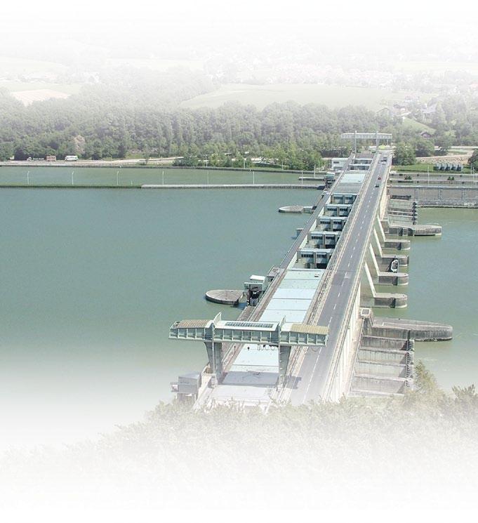
8 Traffic management Traffic management is carried out by waterway administrations aiming for optimal utilisation of the infrastructure and assurance of safe navigation. It can include local traffic management as well as lock and bridge management: Local traffic management is provided by Vessel Traffic Service (VTS). VTS/RIS centres are currently installed at critical points along the European waterway network. These centres are implemented by competent authorities to improve the safety and efficiency of vessel traffic, and to protect the environment. The service has the capability of interacting with the vessel traffic and responding to traffic situations developing in the Vessel Traffic Services area. The information required by local traffic management is gathered by means of permanent shore-based radar stations and an inland Automated Identification System network. AIS provide additional information, such as the identity and actual position of the vessel. In addition, voyage reporting systems provide information on the vessels, their cargo and the intended voyages. These information sources provide to local traffic management the necessary information to inform and advise the traffic in potentially unsafe traffic situations or in order to increase the efficiency of the traffic flow. Lock and bridge management supports operators in planning the use of these infrastructures by providing a Strategic Traffic Image. These services assist the operators in the calculation of estimated and requested time of arrival (ETA and RTA) of vessels. As this allows optimal planning of locking operations, the smooth passage of vessels through locks and bridges, often considered as bottlenecks in inland waterways, can be realised. Lock planning can reduce waiting times significantly. In turn, lock operators can inform the individual skipper of his requested time of arrival, enabling him to adapt his speed and possibly save on fuel. Calamity abatement support The calamity abatement support registers vessels and their transport data at the beginning of a journey and updates the data during the voyage. In the event of an accident, the authorities are then able to provide data immediately to the rescue and emergency teams. The Electronic Navigational Charts and the Tactical Traffic Image provide the basis for the coordination of rescue forces and nautical measures. 6
9 Information for transport logistics Information services for transport logistics facilitate the planning and execution of transport and logistics services as these will allow voyage planning, transport management, port and terminal management as well as cargo and fleet management. Voyage planning includes the planning of the optimal route, the draught and the estimated time of arrival (ETA) of the vessel. Skippers and fleet managers need fairway information to make these plans. Transport management means the management of the transport chain, and is driven by freight brokers and transport service managers. It is aimed at: - improving the overall performance of the contracted fleet; - controlling the progress of the contracted transports; - monitoring unexpected deviations to the reliability of these transports; and - facilitating the billing of the logistics services. Intermodal port and terminal management provides operators with the information they need about the estimated time of arrival of the vessel and its load in order to plan resources for terminal operations. This arrival information supports the overall terminal utilisation and allows smooth passage of vessels through the terminal facilities. As a result, the transshipment time can be reduced. Additionally, in situations where there is temporarily insufficient terminal capacity, the terminal operator can inform the individual skipper of a requested time of arrival. Better slot management is possible as a result of the exchange of estimated and requested time of arrival data. Cargo and fleet management is based on information about loaded and available empty vessels including the actual vessel positions, their requested or estimated times of arrival, the cargo transported, the cargo to be shipped, and information on the terminals. Information for law enforcement RIS support law enforcement in inland navigation, both in cross-border management, such as the movement of people controlled by the immigration service, customs, etc, and in compliance with the requirements for traffic safety and with the environmental requirements. Statistics RIS can be used to collect relevant inland waterway traffic and freight statistics. Since data already collected for other services can be used, skippers and terminal and lock operators will no longer need to provide special statistics. Electronic data collection will facilitate the process for data providers and statistical offices. The statistics are of interest to the waterway authorities, international organisations and companies engaged in inland navigation and will be used to optimise strategic planning and monitoring. Waterway charges and harbour dues RIS can assist in levying charges for the use of infrastructure. The voyage data of a ship can be used to automatically calculate the charge and initiate invoicing, thus facilitating the process for waterway users and authorities. 7

10 3 Benefits The major benefits of the implementation of RIS can be summarised as: increased competitiveness; optimised use of infrastructures; improved safety; reduced carbon emissions; and increased energy efficiency. Unlike traditional traffic management concepts, RIS follow an integrative approach, not only focusing on the needs of traffic management, but also aiming at maximum benefits for the transport users and the environment. RIS facilitate the establishment of competitive inland waterway transport services, as well as their integration into the entire transport chain, because they comply with the information needs of modern logistics chain management. RIS permit information interfaces with all logistics chain members as well as with other transport modes. RIS enable further real-time monitoring of the fleet and of changing fairway conditions on the route. This allows improved fleet management, including an optimised deployment of the vessels and personnel, as well as better voyage planning. The provision of estimated times of arrival and information such as stowage plans and vessel dimensions, amongst others, enables terminal and lock operators to optimise the use of the infrastructure and resources. For skippers this means a reduction in waiting times. RIS also facilitate the collection and provision of statistical data in an automated and efficient way, which ultimately results in lower public expenditure. Skippers are offered up-to-date and complete overviews of traffic situations by means of Electronic Navigational Charts, precise positioning data on approaching vessels, and electronic information about fairway and weather conditions. This allows them to take wellinformed navigational decisions which will further increase safety. Transparency is a main prerequisite for enhanced execution of transport operations. Port operators can reduce paperwork for the collection of port dues as well as enhance calamity abatement as the port operator has additional information available. RIS support the generation of comprehensive and transparent information processes and the smooth exchange of data (preannouncement declarations, exchange of data on cargo/containers, etc). Cargo shippers and freight brokers can obtain cargo and voyage data, especially the estimated times of arrival and use it for preparation of their logistics processes. RIS contribute to better energy efficiency by reducing fuel consumption as a consequence of better voyage planning and more reliable scheduling. The services further provide the possibility of monitoring the transport of dangerous goods. This allows fast response in the event of accidents and potential environmental calamities. Authorities can enhance their services for the sector and streamline administrative processes by means of electronically available information. 8

11 4 Case studies Case study: Vessel Traffic Services in the area of Nijmegen (the Netherlands) In the network of Dutch rivers and channels, the River Waal is by far the most important shipping lane and densely trafficked river in Western Europe. On average, 160,000 ship movements transport 170 million tonnes of cargo annually via this waterway. Most of the cargo is transported from the port of Rotterdam to Germany and vice versa. But the River Waal is also an important element in the transport chain between Amsterdam and Germany as well as for transport in the North-South direction. Vessel Traffic Services (VTS) were set up in order to guarantee safety of traffic and an efficient passage as well as to safeguard the environment. These Vessel Traffic Services are an important element of RIS as they provide traffic management in areas with high traffic density. Local traffic management in Nijmegen has been in operation for several decades. In the 1980s local traffic management activities started in a restricted area in order to make convoys of up to six barges both possible and safe. In 1999 the local traffic management was extended towards the border with Germany. In 2003 the new VTS/ RIS centre was opened and new equipment was installed. The current system is composed of seven unmanned radar stations and three consoles with central equipment installed in the VTS/RIS centre. The system interfaces with other RIS systems like Electronic Reporting (ERI) and the Dutch Ship Reporting System IVS90. 9

12 Case study: Lock management on the Austrian Danube From 1 January 2009 the handwritten lock diary was replaced by an electronic tool supporting the management of all locking operations and processes on the nine Austrian Danube locks. Following a successful implementation and several months of parallel operation, the new system was officially launched on 1 January Among the main tasks of the new system are the standardised documentation of all operational lock processes and the complete data registration of all completed lock operations. This includes detailed information on every single lock operation, such as the grouping of vessels or convoys, convoy formations, or entrance, exit and waiting times. Based on these data, the system enables the compilation of extensive statistics while reducing the administrative costs involved. A close system connection with the Austrian AIS infrastructure, as well as automatic vessel identification via voice radio, further supports the lock personnel. The transmission of lock data between neighbouring locks along with a graphic display of the traffic situation at the upstream and downstream sections of the lock provides detailed information on the approaching vessel traffic at every lock on the Austrian stretch of the Danube. Besides the dramatic reduction of the workload of the operators, the system also has benefits for skippers. Computer aided optimisation of the lock chambers and improved planning capability by the usage of AIS data results in increased throughput and reduced waiting times. The reduction of administrative burden and communication needs via VHF enables the operators to focus more on traffic safety. I am responsible for the management of the traffic through the locks on the Austrian Danube. From my point of view, the new RIS system has drastically reduced administrative procedures and relieved the lock personnel while providing them with optimal support in their daily procedures for planning, execution and documentation of pending lock operations. Hans-Peter Wegscheider, Head of Traffic Management at via donau 10
13 Case study: Calamity abatement in Flanders Accidents are rare in inland waterway transport, but in the event that one does occur, the skipper has to inform the authorities. These will ask rescue and emergency teams to assist the vessel and limit dangers to the environment. Calamity abatement support, which is an important element of RIS, can provide information about the vessel and its cargo. Moreover, RIS can assist in the information exchange. In this way, the abatement measures can be executed effectively and the danger to people and the environment can be minimised. Because of the complex alarm chain in case of a calamity, Flanders invested in a RIS system, called C@LRIS, for handling calamities. Depending on the region, the classification and the severity of an incident, different persons need to be informed. C@LRIS is used in both Flemish RIS centres, Hasselt and Evergem, resulting in a fail-safe redundant system. The principal objectives of C@LRIS are: 1. Enrich an incoming calamity notification: C@LRIS relies on basic RIS key applications to enrich an incoming notification of calamities. In case of an incident with a vessel, C@LRIS can provide the position of the ship, its cargo and number of persons onboard. 2. Inform people in charge of operations: Different people mean different ways of communication. C@LRIS will automatically propose the correct set of responsible people. All communication is logged by the application. 3. Inform skippers and other waterway authorities: After rescue forces are alerted, C@LRIS will inform the skippers. 4. Monitor the situation: During the calamity, the RIS operator is continuously informed. RIS information is displayed on the video wall of the RIS centres. 5. Cancellation of the calamity: When the calamity is over and no further actions are required, all contacted people will be informed. Overview of calamity chain GOPA-Cartermill 2010, based on information from Waterwegen en Zeekanaal NV 11
, which is responsible for the management and development of French waterways, decided to prepare ENCs for the River Garonne.")
14 Case study: ENCs for transporting Airbus structures on the Garonne (France) The production of inland Electronic Navigational Charts is ongoing for all major European inland waterways. Voies Navigables de France (VNF), which is responsible for the management and development of French waterways, decided to prepare ENCs for the River Garonne. These charts were produced in order to support the navigational safety of highly sensitive goods, the structures of the new Airbus A380. These very large aircraft body parts were imported by sea and then transported by inland waterway and then road to the plant in Toulouse for final assembly. The ENCs were extremely important for the safety of navigation, as the barges had to sail underneath Bordeaux's bridges where the room for manoeuvre was extremely tight. Additional constraints arose from the classification of the Pont de Pierre bridge in Bordeaux as a historic monument. In order to give permission for their transportation, French authorities needed very strong assurance that the navigation of the Airbus structures below the bridge was absolutely safe. Furthermore, Bordeaux is an estuary area and therefore subject to strong tides. Therefore, studies on the tidal influence had to be prepared, involving the calculation of bathymetric data and navigation times with extremely high precision. The chart production therefore required the investigation and the collection of precise data on the waterway network, with actual depth data and topographic levels being surveyed with extremely high accuracy. 12 Airbus
15 Case study: Electronic Reporting in Germany In the early 1990s, in order to protect crews, people ashore, and the environmenrt, administrations in charge of navigation on the River Rhine considered that the provision of essential information would be crucial in dealing rapidly and efficiently with accidents involving dangerous goods. A German software called MIB (Melde- und Informationssystem Binnenschifffahrt) was put into use in Germany, France and Switzerland, while a separate reporting system, IVS90, was developed in the Netherlands. This calamity abatement service has been in operation since 1994 along the River Rhine. Mandatory reporting applies to vessels carrying dangerous goods, those carrying special goods, tankers, vessels with a length exceeding 110 metres, pushing and towing convoys, passenger cabin vessels and sea-going vessels. As far as trans-boundary traffic is concerned, the exchange of data, where mandatory, among waterway and/or shipping authorities (VTS/ RIS centre) will take place automatically when the vessel concerned crosses the border. Prior to departure, the skipper will convey mandatory data by VHF radio, fax, phone, or Electronic Reporting to the competent VTS/RIS centre. During passage, the skipper will report again when passing a reporting point, when a major change occurs to the data previously reported, or when there is an extended pause in his itinerary. Each VTS/RIS centre will keep the information received as long as the vessel is in its area of competence and will forward such information to the next VTS/RIS centre as the vessel proceeds on its voyage. In the event of an accident, the data stored under MIB is used to generate an emergency report, which is then forwarded to inform both the rescue and salvage units and the authorities responsible for dealing with the accident. In the wake of the accident involving the container vessel Excelsior on the Rhine at Cologne in 2007, a decision was taken to extend mandatory reporting to container vessels. Given the large number of containers carried onboard vessels and convoys, it was considered necessary to adopt mandatory reporting in accordance with a given technical specification. Mandatory Electronic Reporting for vessels either carrying more than 20 ordinary containers or carrying one or more containers containing hazardous substances was introduced on 1 January Skippers used the Dutch software programs BICS (Barge Information and Communication System) or a web application called ERINET for drawing up their electronic reports and transmitted these via the internet or a dial-up connection. Mandatory reporting via VHF radio of a vessel's position and direction of travel remains unaffected. At present, MIB is in use on the River Rhine, the Moselle, the Untermain, the Küstenkanal, and on the waterways Westdeutsches Kanalnetz. Its extension to include other German waterways is currently in preparation. For the time being, mandatory Electronic Reporting for container vessels has been introduced only for vessels navigating on the River Rhine. 13

16 Case study: Traffic management in mixed traffic areas The Scheldt Radar Network (SRN) provides Vessel Traffic Services in a mixed traffic area. It is implemented by a joint cooperation between the Flemish and Dutch organisations which are responsible for the region of the Scheldt River and its approaches. Vessel Traffic Services are provided at all times for about 150,000 ship movements per year. The Scheldt Radar Network works in a mixed mode, i.e. with sea-going vessels and inland barges. It is based on five manned Vessel Traffic Service centres which get Tactical Traffic Information via 21 radar stations. Starting in 2008, the existing traffic management systems were adapted in such a way that services for inland navigation could be enhanced with the implementation of RIS. Subsequently, the radar network was extended with an inland AIS network. Voyage and Strategic Traffic Information is provided by Electronic Reporting. The system contains a route model for the complete working area, which is used for voyage planning. The estimated times of arrival of the vessels are calculated for the different passage points on the voyage and are continuously updated on the basis of the provided requested times of arrival. The information on voyages, via Electronic Reporting, is exchanged with other organisations. Notices to Skippers and Electronic Navigational Charts are provided via the RIS portal. 14

17 Case study: RIS outside of the European Union (Serbia) In Serbia, RIS has had a significant impact on fairway marking and the provision of fairway related information to the skippers. Since the introduction of the pilot system for tracking and tracing on the Serbian Danube in 2007 obtaining information about ship routes at different water levels has been only a few mouse clicks away. This information is very valuable as a feedback for fairway planning and marking. While placing the buoys on the fairway, marking vessels use position information on Electronic Navigational Charts (ENCs) to properly position the buoys. The position of the buoys is sent to headquarters, where ENCs are produced on the basis of inputs from the field. The navigational information about the Serbian stretch of the Danube waterway is published through a common web portal. This web portal is harmonised and language independent, and completely free of charge. This is different to the previous practice of only publishing the marking plan in a single national language. Our administration is in charge of supervising, maintaining and developing international waterways in Serbia. With RIS, we have improved the procedures of our waterway administration significantly. This resulted in tremendous benefits for the waterway users, which are highly appreciated. Moreover, we have introduced new procedures for the data exchange on the common river section with Romania. Consequently, both administrations can publish Electronic Navigable Charts in a synchronised manner with virtually no costs. Differences in projection systems and data formats have been overcome by using state-of-the-art RIS technologies. Today, the skippers navigating through the common stretch of the Danube between Serbia and Romania have no doubt whether Serbian or Romanian ENCs should be used. Both offer the same content and quality. I am very glad that we decided in 2004 to set up and use River Information Services according to European specifications. This was an important element for convincing the European Union to also finance the full roll-out of RIS on the Serbian Danube. Zoran Lukic, Head of the RIS Department at Plovput 15
18 5 Deployment steps A bit of history In the late 1990s, several countries worked on information systems for inland shipping. As their work was not very coordinated, continuation could have led to the implementation of different technologies in each country. Skippers would have had to install several systems for their international voyages. This would have resulted in extra cost and low acceptance. European research, particularly that funded through EU research programmes, has played a very important role in harmonising the development of RIS. The policy development went hand in hand with European research. Research, demonstration and implementation activities have contributed to technology, organisation and policy, and have helped to clear the obstacles to effective realisation of River Information Services. Relevant research projects included the following: Inland Navigation Demonstrator for River Information Services (INDRIS, FP4) demonstrated traffic management for inland navigation and made the first steps towards the definition of River Information Services. Advanced Logistics Solutions for the Waterway Danube (ALSO DANUBE, FP5) focused not only on the development of appropriate IT solutions for transport management, but also generated concepts to create a friendly business environment for waterborne transport in managed intermodal logistics chains. Consortium Operational Management Platform for River Information Services (COMPRIS, FP5) dealt with the pan-european harmonisation of River Information Services, which is a pre-requisite for full installation of RIS on all navigable waterways. The outcome of COMPRIS was a pan-european consensus on RIS system elements, applications and their interfaces. Therefore, COMPRIS was an important milestone towards the pan-european installation of RIS. The publication of the Directive 2005/44/EC marked an important milestone in the implementation of RIS, as it defined binding rules for data communication and RIS equipment as well as the minimum level of River Information Services for future RIS implementations. Supported by the TEN-T Programme, the Master Plan for River Information Services (IRIS Master Plan), a master plan for the implementation of RIS in Europe was finished in Through intensive consultation with all European countries which have navigable waterways, a detailed road map from 2005 to 2013 for the harmonised implementation of RIS in Europe, including budget estimations, was elaborated. The integration of River Information Services into the Multi Annual Programme of the Trans- European Networks for Transport (TEN-T MAP) was another important step. The TEN-T MAP earmarked an indicative budget of 50 million for RIS implementation activities in the European Union between 2007 and The first call for proposals was launched in 2008 and six projects were selected. A second call for proposals was launched in 2010; the next calls are planned for 2011 and In addition to the TEN-T MAP, several European funding schemes have been available for co-financing further development of RIS and its deployment: national funding of countries; Cohesion Funds; the Instrument for Pre-Accession Assistance (IPA); and financial support to logistics companies using RIS (e.g. fleet operators). 16
19 The early phases of RIS deployment The Netherlands and Germany established Vessel Traffic Centres at critical stretches of waterways during the 1980s and 1990s. Both countries started the development of reporting systems in the 1990s. At the end of the 1990s the German waterway administration started with the preparation of Electronic Navigational Charts on the Rhine. Consequently, the German, Dutch, Austrian and other administrations started the production of ENCs. In those years, several authorities started RIS deployment but similar services were implemented differently in each country. The initiative of those countries together with the impulse coming from the research projects led to the start of several RIS deployment projects, which were co-funded mainly from the TEN-T Programme. In the following, a selection of the first RIS implementation projects, which were co-funded by the European Union, is listed. RIS in Austria Donau River Information Services, DoRIS: Starting in 2001, the first traffic management system in Europe based on inland AIS was implemented. With the support of a dedicated programme, most commercial vessels sailing on the Austrian Danube were equipped with AIS transponders. Since July 2008, inland AIS has been mandatory for vessels longer than 20 metres and/or with more than 12 persons onboard. RIS in Hungary Dangerous Cargo Transport Monitoring on Inland Waterways, DaTraM: Since 1996 VHF and IT systems are in operation on the Hungarian section of the River Danube to support inland navigation. Within DaTraM, which started in 2004, the Hungarian administration modernised its centre for calamity abatement support, and implemented and tested an AIS pilot infrastructure, Notices to Skippers and Electronic Reporting. The new systems and procedures enhanced the monitoring of dangerous cargo transportation. The Directive 2005/44/EC and European financial support played an important role in the pan-european roll-out of River Information Services. GOPA-Cartermill 2010, based on information from via donau 17
20 RIS in France and Wallonia Système Information Fluviale (SIF): Starting in 2006, Voies Navigables de France (VNF) and the Walloon fairway authority established a pilot implementation on the Seine-Scheldt waterway axis. A traffic monitoring system and an Electronic Reporting pilot infrastructure were set up. RIS in Croatia Croatia was the second country in Europe with full AIS coverage on the Danube and ready to use ENCs. The RIS centre was financed by the Croatian Ministry of the Sea, Transport and Infrastructure and was opened in 2006 in Vukovar on the Danube. RIS projects included those for the Danube and Drava (both CRORIS) and the Detailed Design and Prototype Installation on the Sava River. Implementation of RIS in Europe I IRIS Europe I was the first RIS deployment project on a pan-european scale, in which the 8 countries (AT/BE/BG/FR/HU/NL/RO/SK) joined forces and upgraded their RIS systems. The project focused specifically on cross-border information services and the related data exchange (see chapter 8). Towards full deployment of RIS After the publication of the Directive 2005/44/EC, comprehensive RIS deployment projects also started in all other European countries with connected inland waterways. As the Directive provides the general framework for a harmonised set of services in all countries, RIS applications will have to be compatible in order to minimise investment costs for the inland navigation sector. In order to guide RIS development, most European countries have linked their national RIS deployment projects through multinational projects with each other. Harmonised RIS deployment across Europe is facilitated through defining new services jointly (see chapter 8). A selection of EU co-funded RIS deployment projects is described below. RIS in Europe Implementation of IRIS Europe II: The second pan-european RIS implementation project focuses on further enhancement and fine-tuning of RIS key technologies, services and applications (see chapter 8). 18
21 RIS in Belgium Implementation of RIS in Flanders: Starting in 2008, the project concerns studies and works undertaken by the two Flemish inland waterway managers and the Flemish sea ports of Antwerp and Ghent in order to comply with the Directive 2005/44/EC. RIS in Belgium and the Netherlands Implementation of RIS on the Westerscheldt River: The Westerscheldt River, located on the border between Belgium and the Netherlands, is a very important axis for waterborne transport and used at high capacity by maritime and inland transport. Starting in 2008, the existing local vessel traffic management systems on the Westerscheldt were adapted in such a way that they will be able to offer information services to maritime and inland vessels (see case study p. 14). RIS in the Netherlands Study and implementation of AIS monitoring network: Since 2009, the Dutch administration has started the implementation of an inland Automatic Identification System monitoring network covering all the waterways of the Netherlands. This includes interfaces with other existing maritime AIS monitoring networks and integration with local traffic management as well as lock and bridge operation. Implementation of Fairway Information Services (FIS) in the Netherlands: Since 2009, the Dutch administration has started to implement a FIS portal aiming at improving the reliability of travel times on inland waterways through the provision of robust (accurate and timely) data for voyages and improving algorithms for estimating travel times in route planning application software. The FIS portal in the Netherlands will include the distribution of Notices to Skippers, Electronic Navigation Charts, information on locks and bridges, information on routes and fairway section, actual and predicted meteorological and hydrological information, as well as rules and regulations. In the future, FIS will also include strategic traffic and transport information provided under strict authorisation principles. 19

22 RIS in the Netherlands and Germany Full deployment of inland AIS transponders: Traffic management making use of inland AIS is only feasible if a high percentage of the vessels are equipped with inland AIS transponders. In order to facilitate a rapid introduction of transponders on the River Rhine, the Dutch and German administrations started an equipment programme to install inland AIS transponders on all vessels longer than 20 metres or all shorter vessels that operate commercially and use the main waterways (class IV and higher) in Germany and the Netherlands. The German and Dutch authorities plan to equip approximately 10,000 vessels between 2008 and RIS in Romania Implementation of RIS in Romania (RoRIS): Since 2000, an AIS-based traffic management infrastructure on the Danube-Black Sea Canal was implemented. Between 2002 and 2006, RIS deployment started on the Danube with the production of Electronic Navigational Charts, implementation of Notices to Skippers, an Electronic Reporting infrastructure, the set up of one national RIS centre, four regional RIS centres and 21 VTS/RIS local centres, and the implementation of VHF radio communication systems and an AIS network. Full deployment of RIS on the Danube and the Danube-Black Sea Canal is planned with the support of the EU Cohesion Funds. As of 2010, Electronic Reporting and NtS infrastructures will be upgraded to the latest technical specifications; the inland AIS and VHF infrastructure will be completed by RIS in Bulgaria Implementation of RIS in Bulgaria (BulRIS): BulRIS started with the preparation of a feasibility study, the production of ENCs and the establishment of a RIS test centre in The tender for establishing the first step of the RIS system was contracted in early Further steps for the full-scale deployment of RIS in Bulgaria are planned up to RIS outside the EU Implementation of RIS in Serbia: Serbia was among the first countries to prepare Electronic Navigational Charts and set up a RIS test centre on the central Danube. In line with Directive 2005/44/ EC, the overall programme for the introduction of RIS on the Serbian Danube started in 2009 and will lead to a full-scale implementation of RIS in 2012 (see case study p.15). Implementation of RIS in the Ukraine: Ukrainian authorities have been preparing Electronic Navigational Charts, operating VTS/ RIS centres and setting up RIS test systems. New services In the context of the EU s Seventh Framework Programme for Research and Technological Development (FP7), projects focus on the development and further harmonisation of new services at two levels: at the level of transport-related services: River Information Services for Transport and Logistics (RISING); at the level of European services: Platform for the Implementation of NAIADES (PLATINA), see chapter 8 for details. 20

; sustainable growth (making our production more resource efficient while boosting our competitiveness); and inclusive growth (raising participation in the labour market, the")
23 6 Policy context Europe looks ahead In March 2010, the European Commission presented the Europe 2020 Strategy (CEC, 2010a), to overcome the economic crisis and prepare the EU economy for the next decade. The European Commission identifies three key drivers for growth, to be implemented through actions at European and national levels: smart growth (fostering knowledge, innovation, education and the digital society); sustainable growth (making our production more resource efficient while boosting our competitiveness); and inclusive growth (raising participation in the labour market, the acquisition of skills and the fight against poverty). This drive for growth and jobs requires ownership at top political level and mobilisation from all actors across Europe. The European Commission s 2020 Strategy consists of a series of flagship initiatives including: decoupling economic growth from the use of resources; supporting the shift towards a low carbon economy; increasing the use of renewable energy sources; modernising the transport sector; and promoting energy efficiency. Intelligent traffic management for all modes of transport, better logistics and pursuing the reduction of CO 2 emissions are examples of measures that could be taken. The European Commission is also preparing a new long-term strategy for the future of transport and mobility. This new White Paper will set policy objectives until It will focus on: a competitive, innovative and environmentally-friendly industry; the removal of bottlenecks and remaining barriers to transport; and looking at people: passengers, clients and transport professionals. Given the need to devise policy solutions that reduce dependency of transport on fossil fuels and to commit to fighting climate change, the European Commission has stated that it aims to construct policy in such a way that the decarbonisation process does not negatively affect achievements in European mobility. Some suggestions include the better integration of transport modes. Transport is shaped by infrastructure. Ideally, railways and inland waterways should increasingly be used for long-distance transport, especially of heavy and bulky cargo, while road should be used for shorter distances and to complement rail and inland waterways on the "last mile". Last but not least, the logistics efficiency of inland waterway transport and their interconnection with the other transport modes needs to be improved. 21
24 River Information Services contribute to enhancing the efficiency of inland navigation. Moreover, they facilitate the integration of transport modes through information exchange across the logistics chain. Another important pillar of the European Commission s activities on Intelligent Transport Systems (ITS) relates to the Trans-European Networks for Transport (TEN-T). As this brochure went to print the European Commission was in the decisive phase of the review of the TEN-T policy. River Information Services together with ITS for other modes of transport represent an important part of the proposed conceptual pillar of the network. River Information Services will enhance the efficient use of infrastructure and are a key to genuine network integration. Within the Freight Transport Logistics Action Plan (CEC, 2007c), the European Commission has outlined the concept of e-freight. This concept is a vision of a paper-free, electronic flow of information associating the physical flow of goods with a paperless trail built by Information and Communication Technologies. It includes the ability to track and trace freight across transport modes and to automate the exchange of contentrelated data for regulatory or commercial purposes. Freight should be identifiable and locatable regardless of the mode used to transport it. For this to happen, standard interfaces within the various transport modes are required to be interoperable across modes. River Information Services form an important element of e-freight. In January 2006, the multi-annual European Action Programme for Inland Waterway Transport (NAIADES), which aims at promoting inland waterway transport (IWT) in Europe, was launched (CEC, 2006). It includes recommendations for actions to be taken between 2006 and 2013 by the European Commission, member states river commissions and the inland navigation sector. The implementation of RIS is an important element of the strategic area infrastructure. 22

25 7 RIS in 2025 a possible way forward Where does RIS stand today? The Directive 2005/44/EC applies to 12 EU member states and one candidate country (Croatia). Serbia, Switzerland and the Ukraine are not formally concerned, however all three are undertaking significant steps in RIS deployment. Since the 1980s, much has been achieved by the administrations and the private sector. A few examples of the state-of-the-art in 2010: Electronic Navigational Charts are provided for approximately 70% of the major European waterways. On the Danube and the Rhine full coverage has already been achieved. More than 6,000 vessels - commercial vessels and pleasure crafts alike - are already equipped with inland Electronic Chart Display and Information Systems (ECDIS) viewers, which represents approximately 45% of the total fleet. Authorities from 12 countries provide Notices to Skippers. At some dangerous spots in the waterway network there are VTS/RIS centres to improve the safety, increase the efficiency and safeguard the environment. In the Scheldt River an important maritime connection to Antwerp RIS are included in the local traffic management system for mixed traffic. The Netherlands and Germany have ship reporting systems in operation and exchange the reported information. The systems can be used for increasing the efficiency of lock and bridge operations and for calamity abatement support. Approximately 20% of the fleet reports cargo and voyage data electronically. For container vessels, Electronic Reporting is already mandatory on the River Rhine. Authorities from six EU member states and Serbia have started equipment programmes for inland AIS transponders, aiming at equipping up to 13,000 inland vessels, which is nearly the entire motorised fleet. Inland AIS infrastructures support traffic management in 12 countries. In the last decade, authorities have made significant efforts in implementing RIS. Much has been achieved already but additional steps are needed to make services more efficient and to make them available for the entire inland waterway network. The inland navigation sector has taken up RIS. In 2010 RIS applications still focus very much on the safety of inland navigation while automatic information exchange with terminal operators, freight brokers and shippers is used primarily in pilot operations. 23

26 A vision for 2025 and beyond RIS implementations in 2025 will be based upon stable technologies fully adapted to the needs of inland waterway transport (IWT). National RIS implementations will be fully harmonised and seamlessly implemented along the entire European inland waterway network. In 2025, authorities will provide RIS not only for the major waterways, but for all navigable waterways. Therefore, Electronic Navigational Charts of smaller waterways will have to be provided as well. Efficient update procedures, especially with relation to actual depth information and dynamic information (e.g. water level information) are expected to be available for skippers. Notice to Skippers information will be available from every RIS provider for navigable rivers of all sizes and automatically included in ENCs and voyage planners, so that route planning will be supported with automatic information from authorities. It is expected that these services will not only be used by cargo and passenger vessels, but also by pleasure craft. From a user s point of view RIS applications will be integrated with each other and will be available in all wheel houses as they will be integrated with the standard navigation equipment. RIS technologies will no longer be seen separately but be merged into a homogenous onboard system which can be adapted to the needs of the skipper. In order to enhance safety of navigation, navigational support systems will track and integrate radar, AIS and other sensor data like rate-of-turn, showing real and accurate vessel outlines in 3D displays. In addition, the ENC data will be fully available in 3D, providing the possibility for heads-up display. High precision positioning based on Galileo and accurate integrated navigation receivers will allow for navigational support systems similar to those in air transport. Such systems will not only ease lock and bridge passages, but also provide automated docking assistance, path keeping and auto-piloting. Intelligent algorithms onboard will allow for automatic collision detection and emergency manoeuvring. In order to enhance the efficiency of inland navigation, voyage planning applications will 24

27 provide guidance for efficient navigation with regard to transport time, fuel consumption and emissions. Such systems will consider fairway and traffic information, as well as lock and harbour schedules, to calculate optimal route plans and ETAs. These will also support the automatic selection of the optimum track on the fairway by considering precise real-time data on waterway depth and traffic information allowing optimised loading and safety. Through information exchange by RIS, inland navigation will develop the capacity to be managed in time slots at, for instance, locks and ports, in a way that is comparable to air traffic. As a seamless wireless data network will be available throughout Europe, the communication bottlenecks will vanish and allow for broadband services, enabling RIS to be fully integrated in logistics chain management. Accurate timing of transport processes, timed slots for transhipment and continuous tracking and tracing of cargos will be standard, as is the case today in some areas of road freight transport. In 2025, traffic-related River Information Services will be provided by a network of interconnected national and European RIS providers. National and European service providers will deliver according to agreed and guaranteed service levels so that the transport sector can rely on RIS. Users will no longer see the national boundaries but be presented with harmonised seamless services of high quality and reliability. Vessel tracking and tracing will be available throughout Europe and hence contribute to traffic management, as well as to status monitoring and deviation management of logistics chains by freight forwarders and cargo shippers. Reporting of cargo and voyage information will become part of the standard transportation process and will be used to eliminate the borders with other transport modes, especially with maritime transport. Inland and maritime navigation will be based on the same or similar navigation and communication technologies, bringing both even closer together and allowing for homogenous traffic management in ports with mixed traffic. 25

28 Due to a well established legal basis and open data exchange standards, the e-freight concept will become reality and inland navigation will be integrated into managed logistics chains. Evaluation of the legal background for RIS may have identified several candidates for additional technical specifications in order to facilitate the full deployment of RIS. These could be in the following areas: service parameters for River Information Services; technical, legal and organisational definitions for international data exchange and interfaces among (governmental) national and European RIS providers and logistical RIS users; and a minimum set of data to be provided by commercial vessels, for instance carriage requirements of inland AIS transponders, requirements to report cargo and voyage data electronically. Further technical specifications could also consider the implementation progress, especially at the level of new technologies and emerging challenges resulting from the gradual implementation of River Information Services along the entire European inland waterway network. What are the lighthouse initiatives for RIS deployment on the way to 2025 and beyond? What are the leading initiatives that should guide national RIS implementations and RIS deployment by the inland navigation sector? In the first decade of RIS deployment, much has been achieved, but the sets of RIS services provided by national RIS providers need to be further harmonised. In order to enable the RIS providers to offer a harmonised set of RIS services, additional RIS infrastructure needs to be set up and future deployment activities need to be harmonised with one another. This is a continuous and ongoing activity, which is a crucial element for achieving harmonised RIS deployment in Europe (see lighthouse initiative 1). With regards to RIS for transport management, the first steps have been taken at European level within the framework of the research projects ALSO DANUBE and RISING. Preliminary results, especially when comparing the current services with the e-freight system architecture, indicate that there is much potential in those services. In order to reach a fully-integrated logistics chain management, where RIS play an important role, it is necessary to agree on predefined services and data interfaces between the modes on a European level. Furthermore, the access to and exchange of transport-related RIS data has to be agreed at a European level without bureaucratic barriers. Research in the future should focus on this area (see lighthouse initiative 2). The progress in RIS deployment has shown the need for the deployment of European services such as the European reference data management system managing the infrastructure information of the entire European inland waterway network. The first steps for setting up such services have been taken within EU-financed projects, however further development and a more sustainable organisational structure must be on the agenda (see lighthouse initiative 3). 26

29 8 Lighthouse initiatives Lighthouse initiative 1: Harmonised implementation of RIS services by the administrations: IRIS Europe I and II The IRIS Europe initiative focuses on the coordinated Implementation of RIS in Europe. For that purpose the multi national projects IRIS Europe I ( ) and its follow-up IRIS Europe II ( ) co-funded by the European Union within the TEN-T Programme were initiated with the main objective of starting and proceeding with the harmonised implementation of RIS at the European level in order to enhance safety, efficiency, environmental friendliness and thus the attractiveness of inland navigation beyond individual country borders. RIS Europe II Project partners RIS Europe II Cooperation partners GOPA-Cartermill 2010, based on information from via donau 27

30 IRIS Europe I was a multi-beneficiary Europewide project for the pilot implementation and expansion of the functionality of River Information Services (RIS) on the European waterway network. The project addressed the elimination of existing bottlenecks in intelligent infrastructure on European waterways and defined additional functionality for River Information Services in the Danube and Rhine-Seine regions. The project focused specifically on cross-border information services and the related data exchange and procedures. Innovative River Information Services such as traffic and transport information exchange, hull data exchange and calamity abatement were validated by means of interconnected pilot installations. IRIS Europe I was successfully closed by the end of Its successor, the IRIS Europe II project focuses on further enhancement and fine-tuning of RIS key technologies, services and applications based on the results of IRIS Europe I, as well as on new topics. It addresses four main thematic areas: Implementation and enhancement of existing Fairway Information Services in order to provide relevant information such as water depth, water levels and Notices to Skippers to the fairway users in a sophisticated and efficient way. Implementation of pilot infrastructure and enhancement of traffic and transportrelated River Information Services like calamity abatement and Electronic Reporting in order to further increase safety and efficiency of inland navigation. Enhancement of cross-border RIS data exchange through a pilot operation of international exchange of traffic and transport information, as has been specified and piloted within IRIS Europe I. A further enhancement at the functional and geographical level is foreseen as well as the interconnection of national infrastructures to European services like the European Vessel Hull Database. Introduction, monitoring and management of Quality of Information Services for RIS will benchmark the performance of systems and quality of data. This is essential for the acceptance of RIS. Thus, IRIS Europe II also focuses on the definition of minimum quality requirements towards selected technologies and services on European level which will be the basis for further definitions of quality levels on a wider scope within RIS. Outlook after IRIS Europe II: Although the IRIS Europe projects have brought the harmonised implementation of RIS in Europe a major step forward, there is much work to be done in further international projects. It is vital to keep up the pace of continuous improvement of the services and to increase the user-friendliness and added value for all user groups. Future issues after IRIS Europe II might be: further implementation of international RIS data exchange (integration of additional countries, new user groups and services); definition, implementation and maintenance of agreed European service levels for RIS; and development, standardisation and implementation of further services based on the needs and requirements of the governmental and logistics stakeholders within inland navigation. 28
31 Lighthouse initiative 2: River Information Services for transport and logistics: the research project RISING The FP7 project RISING (RIS Services for Improving the Integration of Inland Waterway Transports into Intermodal Chains) has the objective of developing and testing new River Information Services for the European IWT sector and its enterprises. In contrast to other RIS projects, RISING focuses exclusively on the present and future needs of the European transport and logistics sector. Logistics processes Planning phase Execution phase Completion phase RIS support, for instance.. Voyage planning (water levels/ prognoses, lock operation status, etc) Fleet management, capacity management, etc Tracking and tracing of (unpropelled) inland vessels Event Management Ports and terminals (berthing, loading, pre- and post-haulage, etc) Electronic data exchange and document management (ERI, NtS, etc) Invoicing and controlling processes There is a need to exploit existing and identify new River Information Services for almost every step of an IWT-based transport logistics process, from planning to execution and completion. What type of RIS information do you need for logistics processes? Industrie Logistik Linz is a logistics service provider organising the supply chains of various original equipment manufacturers in Upper Austria and the Netherlands. Using inland navigation we transport about half a million tons per year. RIS are very important for us because they provide all the information that we need for the planning and steering of our processes. Primarily we need the current data on the condition of the infrastructure. This means that we require information about water levels and the status of locks and ports. In addition, we need the corresponding forecasts in order to plan our processes. In this context Event Management and Tracking & Tracing play an important role and are essential for the planning and control of inland waterway transport. Ralph Gallob, General Manager of Industrie Logistik Linz Portbase is a port community system provider in the Netherlands managing approximately three million transactions per month for all port sectors. RIS are very important for us because of Event Management. If deviations occur during the voyage or port operations, an updated estimated time of arrival is required. This updated ETA is available at the barge operators and can be shared with the other terminals involved in the planning. Terminals can adopt their planning to the new situation and in this way improve their operational performance. Marten van der Velde, Strategy and Business Development Manager at Portbase RISING demonstrator cases - characterised by different types of commodities such as container, steel products, high & heavy, bulk cargo - will be carried out along the Rhine/ Scheldt, the Danube, and the Elbe/Weser. 29

32 Lighthouse initiative 3: Set-up of first European services In 2006 the European Commission launched the action programme NAIADES, and thereby set up for the first time an integrated and comprehensive inland waterway transport policy. NAIADES is addressed to all stakeholders - the EU, member states and the sector. NAIADES is embedded in the comodality concept aiming at the further development of inland waterway transport and its efficient integration into the overall transport chain. It combines legislative with policy and itemised financial support measures. In 2008 the European Commission launched the FP7 Platform for the implementation of NAIADES (PLATINA), bringing together all relevant stakeholders and establishing a broad knowledge base. Recognising that the coordinated implementation of the European NAIADES action programme is a shared responsibility, the PLATINA consortium is dedicated to supporting the European Commission, member states and third countries, river commissions and the inland navigation sector in the implementation of selected NAIADES actions. Organised along the lines of the NAIADES action programme, five thematic areas are pursued in the work plan of PLATINA. RIS is part of the thematic area Infrastructure. Therefore, PLATINA activities in the area of River Information Services include the following: RIS implementation support European Hull Database RIS data management system RIS portal. 30

33 RIS implementation support PLATINA facilitates the European harmonisation, and implementation of River Information Services through supporting the RIS Expert Groups work, and by streamlining data management and maintenance procedures within and between RIS Expert Groups. European Hull Database Certain inland waterway vessels require a technical inspection before being allowed to sail on European inland waterways. Vessel certification authorities issue community certificates after technical inspections. A subset of the data of community certificates, the so-called minimum set of hull data, includes the Unique European Vessel Identification Number, the name of the vessel, its length and breadth. The minimum set of hull data should be exchanged among vessel certification authorities and with RIS authorities. PLATINA facilitates the implementation of the European Hull Database, which eases this data exchange. In addition, an operational concept for the future operation of the European Hull Database has been prepared. RIS data management system RIS reference data represents the basic element of all RIS applications. This data includes data of the entire inland waterway network, for instance the location of locks, bridges and ports. This data is generated by national authorities. Skippers need the data in RIS applications. Therefore, this data needs to be consolidated and maintained on a structural basis, in order to avoid the use of different data versions in onboard applications. In cooperation with national authorities, PLATINA defined data management procedures and implemented a reference management tool. This facilitates the harmonised generation of reference data. Application manufacturers and RIS users can download this data from one central point. RIS portal A benchmark and inventory to determine the best approach for a one-stop RIS portal was undertaken in cooperation with the RIS Expert Groups, also taking national activities into account. Technical specifications for the RIS portal were approved by the Expert Groups in April Based on these technical specifications the RIS portal ( has been built and was successfully launched during the RIS Expert Groups meetings in November 2009 in Vienna. 31
34 9 Conclusions The RIS concept aims at implementing information services to support the planning and management of traffic and transport operations. Implementing RIS has not only improved traffic safety and environmental protection but also simultaneously enhanced the efficiency of transport operations and increased competitiveness. Although waterway users and authorities are considered the direct beneficiaries from operational improvements, the implementation of RIS has been contributing to a more efficient inland navigation sector, safe navigation, decreased emissions, and lower transport costs. Looking back, the RIS Directive and EU financial support have been paving the way towards harmonised RIS implementation on European waterways. Since the publication of the Directive, much has been achieved. Electronic Navigational Charts, for instance, have been produced for the entire River Danube. On the Rhine, Electronic Reporting was made mandatory for container transportation, to name only two examples. The next steps include the joint development of additional services, in particular for logistics companies using RIS, the set up of European services, further enhancement of the legal framework for RIS and last but not least assuring the continued political and financial support at national and European level in the future. Following implementation of RIS over European waterways, future inland navigation will be more integrated, transparent and safer. Inland navigation in the enlarged EU will continue to develop, effectively supported by RIS. Transport by inland waterways will continue to become an even more user-friendly and environmentally-friendly mode of transport that will facilitate modern logistic integration and intermodal transport. The inland navigation sector and national RIS authorities in cooperation with the European Commission can facilitate the modernisation of inland navigation by means of a harmonised pan-european RIS deployment. 32
35 10 References Note that for projects where no website is given, or further projects related to River Information Services, project information can be obtained from the TRKC website at ALSO DANUBE, Advanced Logistic Solutions for the Danube Waterway ( ), FP5 BICS, Barge Information and Communication System CEC (2006), Communication from the Commission on the promotion of inland waterway transport NAIADES an Integrated European Action Programme for Inland Waterway Transport, Brussels CEC (2007), Commission Regulation (EC) No 414/2007 of 13 March 2007 concerning the technical guidelines for the planning, implementation and operational use of River Information Services (RIS), Brussels CEC (2007a), Commission Regulation (EC) No 415/2007 of 13 March 2007 concerning the technical specifications for vessel tracking and tracing systems, Brussels CEC (2007b), Commission Regulation (EC) No 416/2007 of 22 March 2007 concerning the technical specifications for Notices to Skippers, Brussels CEC (2007c), Communication from the Commission Freight Transport Logistics Action Plan, European Commission, Brussels CEC (2010), Commission Regulation (EU) No 164/2010 of 25 January 2010 on the technical specifications for Electronic Reporting in inland navigation, Brussels CEC (2010a), EUROPE 2020 A European strategy for smart, sustainable and inclusive growth, Brussels 33
36 COMPRIS, Consortium Operational Management Platform for River Information Services ( ), FP5 DaTram, Dangerous Cargo Transport Monitoring on Inland Waterways, TEN-T DoRIS, Donau River Information Services EU (2010), EU Energy and Transport in Figures 2010, Publications Office of the European Union, Luxembourg, European Parliament and Council of the EU (2005), Directive 2005/44/EC of the European Parliament and of the Council of 7 September 2005 on harmonised river information services (RIS) on inland waterways in the Community, Brussels INDRIS, Inland Navigation Demonstrator for River Information Services ( ), FP4 IRIS Europe I and IRIS Europe II, Implementation of RIS in Europe ( ), TEN-T Petersen et al (2009), Petersen M.S., Enei R., Hansen C.O., Larrea E., Obisco O., Sessa C., Timms P.M., Ulied A.: Report on Transport Scenarios with a 20 and 40 year Horizon, Final report TRANSvisions project, Copenhagen, Denmark PLATINA, Platform for the Implementation of NAIADES, ( ), FP7 RISING, River Information Services for Transport and Logistics, ( ), FP7 34
37 Glossary AIS Automatic Identification System BulRIS RIS in Bulgaria BICS Barge Information and Communication System CEC Commission of the European Communities DG MOVE Directorate-General for Mobility and Transport DoRIS Donau River Information Services EC European Commission ECDIS Electronic Chart Display and Information System ENC Electronic Navigational Charts ERI Electronic Reporting ETA Estimated Time of Arrival EU European Union FIS Fairway Information Services FP4/5/5/7 ICT Fourth / Fifth / Sixth / Seventh Framework Programme for Research and Technological Development Information and Communication Technologies IPA Instrument for Pre-Accession Assistance IT Information Technologies 35
38 IWT Inland Waterway Transport INDRIS Inland Navigation Demonstrator for River Information Services ITS Intelligent Transport Systems NAIADES Navigation and Inland Waterway Action and Development in Europe NtS Notices to Skippers RIS River Information Services RoRIS RIS in Romania RTA Requested Time of Arrival SRN Scheldt Radar Network STI Strategic Traffic Information / Image TEN-T Trans-European Network Transport TEN-T MAP Trans-European Network Transport Multi Annual Programme TRKC Transport Research Knowledge Centre TTI Tactical Traffic Information / Image VHF Very High Frequency VTS Vessel Traffic Services 36
39
Use of ITS technologies for multimodal transport operations River Information Services (RIS) transport logistics services
 transport logistics services") Available online at www.sciencedirect.com Procedia - Social and Behavioral Sciences 48 ( 2012 ) 622 631 Transport Research Arena Europe 2012 Use of ITS technologies for multimodal transport operations
Available online at www.sciencedirect.com Procedia - Social and Behavioral Sciences 48 ( 2012 ) 622 631 Transport Research Arena Europe 2012 Use of ITS technologies for multimodal transport operations
Project Data Sheet BASIC PROJECT DATA. IRIS Europe II Implementation of River Information Services in Europe. Full project title:
 BASIC PROJECT DATA Full project title: IRIS Europe II Implementation of River Information Services in Europe Short project title: (acronym) IRIS Europe II Project logo: Project website: www.iris-europe.net
Project Data Sheet BASIC PROJECT DATA. IRIS Europe 3 Implementation of River Information Services in Europe. Full project title:
 BASIC PROJECT DATA Full project title: IRIS Europe 3 Implementation of River Information Services in Europe Short project title: (acronym) IRIS Europe 3 Project logo: Project website: www.iris-europe.net
FLUSSINFORMATIONSSYSTEME IM EUROPÄISCHEN VERGLEICH RIVER INFORMATION SERVICES IN EUROPE. von / by Cas Willems
 FLUSSINFORMATIONSSYSTEME IM EUROPÄISCHEN VERGLEICH RIVER INFORMATION SERVICES IN EUROPE von / by Cas Willems 1 Introduction In the transport branch and definitely in inland shipping the use of information
Standard Summary Project Fiche IPA centralised programmes (Regional / Horizontal programmes ; centralised National programmes)
") Standard Summary Project Fiche IPA centralised programmes (Regional / Horizontal programmes ; centralised National programmes) 1. Basic information 1.1 CRIS Number: 2007/19322 1.2 Title: Danube River Information
Standard Summary Project Fiche IPA centralised programmes (Regional / Horizontal programmes ; centralised National programmes) 1. Basic information 1.1 CRIS Number: 2007/19322 1.2 Title: Danube River Information
Inland waterway transport - European policy framework and challenges
 Inland waterway transport - European policy framework and challenges Joint Statement on Inland Navigation and Environmental Sustainability in the Danube River Basin Kick-off meeting, Orth an der Donau,
Danube waterway- European key transport axis
 Danube waterway- European key transport axis OSCE, Economic and Environmental Forum 29 th of January 2008 Manfred Seitz, via donau Presentation Overview Economic importance of the Danube region European
09/02/2010. The RISING Project. 2 nd Advisory Committee Meeting, Brussels Arne Gehlhaar, ISL
 09/02/2010 The RISING Project 2 nd Advisory Committee Meeting, Brussels Arne Gehlhaar, ISL Agenda Background The RISING Project RISING at Work Summary & Outlook page 1 Agenda Background River Information
ANNEX 2: PRIORITY "PRE-IDENTIFIED PROJECTS ON OTHER SECTIONS OF THE CORE NETWORK (RAILWAYS, INLAND WATERWAYS, ROADS, MARITIME AND INLAND PORTS) "
") ANNEX 2: PRIORITY "PRE-IDENTIFIED PROJECTS ON OTHER SECTIONS OF THE CORE NETWORK (RAILWAYS, INLAND WATERWAYS, ROADS, MARITIME AND INLAND PORTS) " The overall objectives and priorities are set out in chapter
ANNEX 2: PRIORITY "PRE-IDENTIFIED PROJECTS ON OTHER SECTIONS OF THE CORE NETWORK (RAILWAYS, INLAND WATERWAYS, ROADS, MARITIME AND INLAND PORTS) " The overall objectives and priorities are set out in chapter
Inland AIS System Implementation
 I3E South East Europe TCP Best Practice Report Inland AIS System Implementation Document type : Best Practice Report Document version : Final Document Preparation Date : January 11 th, 2011 Classification
STRATEGY Ambitions, Objectives and Core Activities
 STRATEGY 2020 s, Objectives and Core Activities STRATEGY 2020 s, Objectives and Core Activities Imprint VIADONAU STRATEGY 2020 s, Objectives and Core Activities via donau Österreichische Wasserstraßen-Gesellschaft
DANTE - Improving Administrative Procedures and Processes for Danube IWT
 DANTE - Improving Administrative Procedures and Processes for Danube IWT Output 4.2 Guidelines/Recommendations for improved processes [1] [Date: 18/12/2018] [final] 1 Document History Version Date Authorised
Future Research on Inland Navigation A European Perspective. Michael Fastenbauer
 Future Research on Inland Navigation A European Perspective Michael Fastenbauer Smart Rivers 2007 Conference, Louisville, Kentucky September 18 th, 2007 Background The European Union (EU), based on its
Electronic reporting in inland navigation
 Electronic reporting in inland navigation Status and outlook overview Jos van Splunder, Chair of the ERI-Expertgroup CCR RIS Workshop, 18.10.2011 (Brussels) Agenda Introduction Status overview Outlook
ORGANISATIONAL STRUCTURE
 INTRODUCTION IRIS Europe 3 is a multi-beneficiary TEN-T project focusing on further enhancement and finetuning of RIS key technologies, services and applications; in particular the (pilot) implementation
Open letter on the Commission proposal for a Regulation establishing a European Fund for Strategic Investments.
 Open letter on the Commission proposal for a Regulation establishing a European Fund for Strategic Investments. Brussels, 11 February 2015 The undersigned stakeholder associations highlight the important
Kick-off Meeting of the Working Groups for Priority Area 1a of the EUSDR Bucharest, Romania 27 October 2011
 EU Strategy for the Danube Region Priority Area 1a To improve mobility and multimodality: Inland waterways Kick-off Meeting of the Working Groups for Priority Area 1a of the EUSDR Bucharest, Romania 27
DANTE - Improving Administrative Procedures and Processes for Danube IWT
 DANTE - Improving Administrative Procedures and Processes for Danube IWT Transnational IWT barrier reporting tool Output 3.1 1.0 Date: 21/09/2017 Final 2 Document History Version Date Authorised 1.0 final
European Strategy on low emission mobility DG MOVE Isabelle Vandoorne, deputy Head of Unit
 European Strategy on low emission mobility DG MOVE Isabelle Vandoorne, deputy Head of Unit Impact of transport (1/3) is economically important both as: i) individual sector and ii) a foundation for economic
Inland Electronic Navigation Chart production at the Flemish Hydrography (Flanders - Belgium)
") Inland Electronic Navigation Chart production at the Flemish Hydrography (Flanders - Belgium) Dumollin Jasmine, Belgium Flemish Ministry of Mobility and Public Works, Agency for Maritime and Coastal Services,
Inland Electronic Navigation Chart production at the Flemish Hydrography (Flanders - Belgium) Dumollin Jasmine, Belgium Flemish Ministry of Mobility and Public Works, Agency for Maritime and Coastal Services,
***I POSITION OF THE EUROPEAN PARLIAMENT
 EUROPEAN PARLIAMENT 2004 2009 Consolidated legislative document 23.4.2009 EP-PE_TC1-COD(2008)0247 ***I POSITION OF THE EUROPEAN PARLIAMENT adopted at first reading on 23 April 2009 with a view to the adoption
Implementation of Electronic Ship Reporting on the Rhine and on the Moselle perspective of authorities and users, next steps and challenges
 Implementation of Electronic Ship Reporting on the Rhine and on the Moselle perspective of authorities and users, next steps and challenges Content History of Electronic Ship Reporting Uptake of Electronic
INCARNATION. Produced by: Issued by. ISSUS Rainvilleterrasse Hamburg, Germany Phone:
 INCARNATION IDENTIFICATION OF ADMINISTRATIVE AND ORGANISATIONAL BARRIERS AND THE ASSESSMENT OF INFORMATIONAL AND ORGANISATIONAL REQUIREMENTS AND FUNCTIONALITIES OF AN EFFICIENT INLAND NAVIGATION INFORMATION
Impulse Statement: Development of Danube Navigation
 Impulse Statement: Development of Danube Navigation Bratislava, 30 October 2012 Hans-Peter Hasenbichler CEO via donau Central and Easteran European Summit on Transport and Logistics Inland navigation?
The EC introduces the SPIN Thematic Network
 volume 1 : issue 1 - January 2003 : page 1 volume 1 : issue 1 January 2003 In this issue... The EC introduces the SPIN Thematic Network Page 1 Via donau explains the concept of the SPIN Thematic Network
Requirements Analysis
 09/02/2010 Requirements Analysis Advisory Committee Arne Gehlhaar, ISL Agenda Background Requirements RISING Results page 1 Agenda Background Goals / Challenges Approach & Solutions Requirements RISING
Planning the transport
 Demonstration case: Planning the transport by Peter Bachl & Elisabeth Steinhuber Industrie Logistik Linz (ILL) RISING IRIS Europe II Final Event 01.12.2011, 0 Duisburg usbu ILL at a glance company name:
Weather Kickoff Meeting
 Weather Kickoff Meeting - 17 November 2009 - Padideh Gützkow 1 Content 1. Introduction NEA and experience in IWT 2. IWT in Europe Waterway management Industry associations and sector promotion 3. Examples
ECMAR Brokerage Session
 ECMAR Brokerage Session MG 2-6-2019 Moving freight by Water: Sustainable Infrastructure and Innovative Vessels Maurits Huisman maurits.huisman@tno.nl ECMAR Council Member, TNO Agenda Introduction you &
Digital Inland Waterway Area
 Towards a Digital Inland Waterway Area and Digital Multimodal Nodes Ir. L.M. Punter (TNO) Dr. Ir. W.J. Hofman (TNO) October 2017 EUROPEAN COMMISSION Directorate-General for Mobility and Transport Directorate
2016 Connecting Europe Facility (CEF) Transport Calls for Proposals COUNTRY FACTSHEET. Belgium
 Transport Calls for Proposals COUNTRY FACTSHEET. Belgium") 26 Connecting Europe Facility (CEF) Transport Calls for Proposals COUNTRY FACTSHEET Belgium Key facts and figures Evaluation results Eligible vs Recommended proposals by call proposals were selected for
26 Connecting Europe Facility (CEF) Transport Calls for Proposals COUNTRY FACTSHEET Belgium Key facts and figures Evaluation results Eligible vs Recommended proposals by call proposals were selected for
Project Data Sheet BASIC PROJECT DATA. Green Engineering for Challenges in Inland Navigation: The Danube Perspective. Full project title:
 BASIC PROJECT DATA Full project title: Green Engineering for Challenges in Inland Navigation: The Danube Perspective Short project title: (acronym) Green Chain Project logo: Project website: Project ID:
2. Therefore the Presidency has decided to develop Council conclusions on the potential of this mode of transport.
 REPORT From: To: General Secretariat of the Council Permanent Representatives Committee/Council No. prev. doc.: ST 12987/18 TRANS 442 MAR 142 Subject: Council conclusions on Inland Waterway Transport see
Intelligent Transport Systems Action Plan - Key questions and answers
 MEMO/08/789 Brussels, 16 December 2008 Intelligent Transport Systems Action Plan - Key questions and answers Summary Typical and well known ITS application are the so-called "GPS" navigation systems in
Project Data Sheet BASIC PROJECT DATA. Full project title: Vessel Traffic Management Information System Phase 3. Short project title: (acronym)
") BASIC PROJECT DATA Full project title: Vessel Traffic Management Information System Phase 3 Short project title: (acronym) VTMIS-3 Project logo: Project website: https://www.vtmis3.eu/en/ Project ID: PA1A014
BASIC PROJECT DATA Full project title: Vessel Traffic Management Information System Phase 3 Short project title: (acronym) VTMIS-3 Project logo: Project website: https://www.vtmis3.eu/en/ Project ID: PA1A014
Mandatory Introduction of Electronic Reporting for Inland Navigation on the Rhine - Information Document for the Shipping Industry -
 Mandatory Introduction of Electronic Reporting for Inland Navigation on the Rhine - Information Document for the Shipping Industry - Annex Pursuant to CCNR Resolution 2007-II-20, as of April 1st, 2008
Why using Inland waterway transport?
 Why using Inland waterway? Why using inland waterway? An European insight related to the use of inland waterway... Why get stuck in a traffic jam and miss deadlines, when you can cut costs and deliver
SOUTH EAST EUROPE TRANSNATIONAL CO-OPERATION PROGRAMME
 SOUTH EAST EUROPE TRANSNATIONAL CO-OPERATION PROGRAMME 3 rd Call for Proposals Terms of reference Network of (Hub) cities for an increased access and mobility of people in the SEE region March 2011 1.
Electronic Data Messages
 Electronic Data Messages The use of electronic messages to ensure good quality reporting. Relationship between the IFTMIN and ERINOT messages Author : Mr. de Lijster Co-author : Mr. Oudenes Document number
SPECIFICATION OF MINIMUM FIS DATA SET
 NETWORK OF DANUBE WATERWAY ADMINISTRATIONS South-East European Transnational Cooperation Programme SPECIFICATION OF MINIMUM FIS DATA SET - DESCRIPTION OF FIS PORTAL CORE SERVICES - Document ID: O 5.28
ANNUAL ACTIVITY REPORT OF COORDINATOR KAREL VINCK ERTMS PROJECT. Brussels. August 2008
 ANNUAL ACTIVITY REPORT OF COORDINATOR KAREL VINCK ERTMS PROJECT Brussels August 2008 This report only represents the opinion of the European coordinator and does not prejudge the official position of the
ANNEX ANNEX. to the. Commission implementing Decision
 EUROPEAN COMMISSION Brussels, 12.10.2018 C(2018) 6599 final ANNEX ANNEX to the Commission implementing Decision on the financing of the Connecting Europe Facility - Transport sector and the adoption of
Inland Waterways Infrastructure in the Czech republic. Lubomír Fojtů Waterways Directorate of the Czech Republic
 Inland Waterways Infrastructure in the Czech republic Lubomír Fojtů Waterways Directorate of the Czech Republic 1 Inland waterways network Elbe state border - Mělník 111 km CEMT class Va Important traffic
COMMUNICATION FROM THE COMMISSION. Blue Belt, a Single Transport Area for shipping
 EUROPEAN COMMISSION Brussels, 8.7.2013 COM(2013) 510 final COMMUNICATION FROM THE COMMISSION Blue Belt, a Single Transport Area for shipping EN EN COMMUNICATION FROM THE COMMISSION Blue Belt, a Single
Danube Ports centres of intermodal logistics and economic growth
 Danube Ports centres of intermodal logistics and economic growth ESPO 2013 Conference Manfred Seitz, General Secretary E-Mail: seitz@prodanube.eu Varna,, 30 May 2013 What is Pro Danube International? Platform
European Economic and Social Committee OPINION
 European Economic and Social Committee TEN/532 NAIADES II package Brussels, 21 January 2014 OPINION of the European Economic and Social Committee on the NAIADES II package, comprising the Proposal for
EasyWay Project An overview
 EasyWay Project An overview Andreas Arnaoutis 26-06-09, Thessaloniki www.easyway-its.eu EasyWay : from systems to services 2 Background EasyWay follows on from the success of the TEMPO programme (MIP I),
ITS Action Plan- Internet Consultation
 ITS Action Plan- Internet Consultation * What are Intelligent transport Systems (ITS)? Intelligent Transport Systems (ITS) are generally defined as a collection of applications and services based on advanced
Developments in the EU Inland Navigation Policy
 88th session of the Danube Commission 9 June 2017 - Budapest Developments in the EU Inland Navigation Policy Bernardo URRUTIA Ports and Inland Navigation Unit European Commission - DG MOVE Inland Waterways
NELI Inland Navigation and Ports Course - curriculum -
 Cooperation-Network for logistics and nautical education focusing on Inland Waterway Transport in the Danube corridor supported by innovative solutions NELI Inland Navigation and Ports Course - curriculum
Towards truly multimodal EU corridors ERTICO- ITS EUROPE
 Towards truly multimodal EU corridors ERTICO- ITS EUROPE Table of Contents The ERTICO Partnership Freight Transport and Logistics programme Connectivity for freight and Logistics Interfaces for an integrated
Innovation & Safety interaction
 Innovation & Safety interaction FOSTERING sustainable mobility across europe EasyWay focuses on the deployment of core services (95% of the budget) which aim to provide European travellers with harmonised
Proposal for a REGULATION OF THE EUROPEAN PARLIAMENT AND OF THE COUNCIL
 EUROPEAN COMMISSION Brussels, 19.10.2011 COM(2011) 650 final 2011/0294 (COD) C7-0375/11 Proposal for a REGULATION OF THE EUROPEAN PARLIAMENT AND OF THE COUNCIL on Union guidelines for the development of
CENTRAL COMMISSION FOR THE NAVIGATION OF THE RHINE. Leaflet. Inland AIS. Edition: 2011 Page 1
 CENTRAL COMMISSION FOR THE NAVIGATION OF THE RHINE Leaflet Inland AIS Edition: 2011 Page 1 Edition: 2011 Page 2 Leaflet Edition 2011 Contents Inland AIS 1. Principles... 5 1.1 Scope... 5 1.2 Purpose of
Implementation of River Information Services in Serbia
 EU Danube Region Strategy: Technical Secretariat for Priority Area 1a: To improve mobility and multimodality: Inland waterways Working Group 4: "River Information Services" Implementation of River Information
Corridor VII, the Danube Backbone of the EU-Strategy for the Danube Region EUSDR
 Corridor VII, the Danube Backbone of the EU-Strategy for the Danube Region EUSDR Otto Schwetz Counsellor of the Senate of the City of Vienna ret. President of PIANC Austria Chairman of the Pan-European
The case FOR inland waterway transport. Inland Navigation Europe Geneva, 23 February 2010
 The case FOR inland waterway transport Inland Navigation Europe Geneva, 23 February 2010 1 Inland Navigation Europe (INE) Founded in 2001 with support of European Commission - no commercial interests Initiative
European Truck Platooning Challenge (pilot) 2016
 2016") European Truck Platooning Challenge (pilot) 2016 Shipper s viewpoint Truck platooning comprises of a number of trucks closely following each other. This forms a platoon with several trucks reciprocally
European Truck Platooning Challenge (pilot) 2016 Shipper s viewpoint Truck platooning comprises of a number of trucks closely following each other. This forms a platoon with several trucks reciprocally
Medium and long term perspectives of Inland
 Medium and long term perspectives of Inland Waterway Transport in the European Union Martin Quispel, NEA Brussels, 5th of July draft version 6a, 30th of June 2011 Contents Introduction Current position
THE BALTIC SEA MOTORWAY - RECENT DEVELOPMENT AND OUTLOOK FOR THE FUTURE
 Journal of Maritime Research, Vol. IV. No. 2, pp. 21-30, 2007 Copyright 2007. SEECMAR Printed in Santander (Spain). All rights reserved ISSN: 1697-4840 THE BALTIC SEA MOTORWAY - RECENT DEVELOPMENT AND
082596/EU XXIV. GP. Eingelangt am 25/05/12 COUNCIL OF THE EUROPEAN UNION. Brussels, 25 May /12 TRANS 177 MAR 75
 082596/EU XXIV. GP Eingelangt am 25/05/12 COUNCIL OF THE EUROPEAN UNION Brussels, 25 May 2012 10418/12 TRANS 177 MAR 75 COVER NOTE from: Secretary-General of the European Commission, signed by Mr Jordi
Feedback by attendants on draft Road Maps. 2nd meeting of Working Groups Vienna, 15/16 March 2012
 Feedback by attendants on draft Road Maps 2nd meeting of Working Groups Vienna, 15/16 March 2012 Disclaimer Please note that this document contains the original or abridged versions of the anonymous feedback
STATUS QUO REPORT ON ENC ACTIVITIES
 NETWORK OF DANUBE WATERWAY ADMINISTRATIONS South-East European Transnational Cooperation Programme STATUS QUO REPORT ON ENC ACTIVITIES RO - ACN Document ID: Activity: 5.2 Author / Project Partner: Date:
ITS for the transport system European and national activities
 AustriaTech Federal Agency for Technological Measures Ltd. ITS for the transport system European and national activities R. Pfliegl, AustriaTech Zagreb, Oct 19th, 2009 Agenda AustriaTech Vision Projects
MINUTES RIS COMMON ISSUES MEETING
 MINUTES RIS COMMON ISSUES MEETING Date 18th November 2009 Location Duration Participants via donau Österreichische Wasserstraßen-Gesellschaft mbh Donau-City-Straße 1 A-1220 Wien 9.00 17.00 hs DG-TREN:
e-navigation Frequently Asked Questions
 e-navigation Frequently Asked Questions 1. What is e-navigation? e-navigation is an International Maritime Organization (IMO) led concept based on the harmonisation of marine navigation systems and supporting
INEA Corridor report: state of play of CEF funding for Rhine-Alpine CNC. Peter Van Bockland Rhine-Alpine Corridor Technical Advisor, INEA
 INEA Corridor report: state of play of CEF funding for Rhine-Alpine CNC Peter Van Bockland Rhine-Alpine Corridor Technical Advisor, INEA Outline CEF support to the Coordinator's Work Plan CEF Action Portfolio:
15050/17 VK/nc 1 DGE 2A
 Council of the European Union Brussels, 28 November 2017 (OR. en) 15050/17 REPORT From: To: General Secretariat of the Council Council No. prev. doc.: 14307/17 Subject: TRANS 524 TELECOM 324 MI 886 CYBER
The AnNa Project MARITIME SINGLE WINDOW. Brisbane, 6 th May Implementing Directive 2010/65/EU
 The AnNa Project MARITIME SINGLE WINDOW Implementing Directive 2010/65/EU Brisbane, 6 th May 2014 Mr. Ir Pieter Verbakel MIM Deputy Project Coordinator 12/05/2014 Content EU policy (general - customs -
THE DANUBE CORRIDOR A DEVELEOPMENT GENERATOR. a company of
 a company of Smart Rivers 21 New Orleans 2011 1 Corridor VII, the Danube Measures for Development of Inland Navigation Otto Schwetz Counsellor of the Senate of the City of Vienna ret President of PIANC
CEF Transport Info day 2016 Greece
 Calls for proposal CEF-T 2016 CEF Transport Info day 2016 Greece Athens- 02 December 2016 Gaspare L'Episcopia- Innovation and Networks Executive Agency (INEA) Summary - - - - CEF Transport Priorities CEF
Proposal for a REGULATION OF THE EUROPEAN PARLIAMENT AND OF THE COUNCIL
 EUROPEAN COMMISSION Brussels, XXX COM(2011) 650/2 2011/xxxx (COD) Proposal for a REGULATION OF THE EUROPEAN PARLIAMENT AND OF THE COUNCIL on Union guidelines for the development of the Ttrans-European
Benefits of cooperation at the EU level:
 : Symposium on test areas for autonomous ships Benefits of cooperation at the EU level: ad hoc group on MASS - VTS angle 9 May 2018 Jacob Terling Maritime Safety DG MOVE D.2 Introduction Development towards
Policy context & Projects on the comprehensive network
 10.05-10.30 Policy context & Projects on the comprehensive network 2019 CEF Transport call Virtual Information Day 17 January 2019 João Ferreira Policy officer in the Unit for 'Transport 'investment' Directorate-General
EUROPEAN SEA PORTS ORGANISATION ASBL/VZW ORGANISATION DES PORTS MARITIMES EUROPEENS ASBL/VZW
 EUROPEAN SEA PORTS ORGANISATION ASBL/VZW ORGANISATION DES PORTS MARITIMES EUROPEENS ASBL/VZW European Commission Green Paper TEN-T: A policy review Towards a core and comprehensive network policy contribution
The World Association for Waterborne Transport Infrastructure InCom WG 210. Smart Shipping on Inland Waterways. Terms of Reference
 PIANC The World Association for Waterborne Transport Infrastructure InCom WG 210 Smart Shipping on Inland Waterways Terms of Reference By Ann-Sofie Pauwelyn, Belgium, De Vlaamse Waterweg nv Lea Kuiters
ICT and e-learning in Intermodal Transport
 1 International Project Forum Croatian - Montenegrin bilateral cooperation program in the field of science and technology ICT and e-learning in Intermodal Transport 12th October 2011, Zagreb Ivan Grgurević,
THE FUTURE OF TRANSPORT
 THE FUTURE OF TRANSPORT Just add water Contribution to the white paper European Barge Union, Inland Navigation Europe and European Skippers Organisation Since the last white paper in 2001, the Union has
COOPERATIVE LOGISTICS FOR SUSTAINABLE MOBILITY OF GOODS
 1 1st SCORE@POLIBA Workshop December 3rd-5th, 2014 COOPERATIVE LOGISTICS FOR SUSTAINABLE MOBILITY OF GOODS Maria Pia Fanti, G. Iacobellis, A. Gallone, N. Augenti Funding: EU, Competitiveness and innovation
Maritime Navigation and Information Services MarNIS i.r.t. River Information Services
 Maritime Navigation and Information Services MarNIS i.r.t. River Information Services Lea Kuiters Technical Coordinator of MarNIS Why MarNIS on a Smart Rivers conference? RIS paved the way for MarNIS Co-modality
Environmentally sustainable improvement of IWT on the Danube. DI Markus Simoner June 25 th 2007, Cernavoda
 Environmentally sustainable improvement of IWT on the Danube DI Markus Simoner June 25 th 2007, Cernavoda Agenda 1. via donau company profile 2. Ecological impacts of IWT 3. European activities to promote
INTERMODAL TRANSPORT IN THE POLICY DOCUMENTS CONTEXT
 INTERMODAL TRANSPORT IN THE POLICY DOCUMENTS CONTEXT Olivera Medar a*, Branislav Bošković a a University of Belgrade, Faculty of Transport and Traffic Engineering, Serbia Abstract: It is the policy analysis
Ernest Godward, EU Agency for Railways. Rail Freight in the European Union
 Ernest Godward, EU Agency for Railways Rail Freight in the European Union A European Rail Freight is facing multiple challenges Organising rail freight is time-consuming Rail freight customers often experience
e-navigation workshop
 e-navigation workshop EU initiatives related to the integration of the maritime information systems 1 17 and 18 October 2012 Haugesund, Norway Lazaros Aichmalotidis Head of Unit C.2 Vessel traffic and
EUSDR PA1a&PA11 working group meeting on administrative processes
 EUSDR PA1a&PA11 working group meeting on administrative processes Budapest 24 October 2017 Ministerul Transporturilor Welcome Statement XY, Danube Commission Slide No. 2 Introduction: The cooperation between
VESSEL TRACKING AND TRACING STANDARD
 Conscious of the importance of the Sava River for the economic, social and cultural development of the region, Desirous of development of the inland navigation on the Sava River, Considering that the Directive
PINE. Prospects of Inland Navigation within the Enlarged Europe. Summary
 PINE Prospects of Inland Navigation Summary Buck Consultants International (The Netherlands) ProgTrans (Switzerland) VBD European Development Centre for Inland and Coastal Navigation (Germany) via donau
DaHar Danube Inland Harbour Development
 The European Union's Southeast Europe programme supporting DaHar Danube Inland Harbour Development Local Action Plan Silistra English version This project is co-funded by the European Union A project implemented
Copyright: S. Werner. Status-Quo of the EMMA. Stefan Breitenbach. Head of Project Department Port of Hamburg Marketing
 Copyright: S. Werner Status-Quo of the EMMA Stefan Breitenbach Head of Project Department Port of Hamburg Marketing 1 The Interreg Baltic Sea Region Programme Project EMMA AIMS TO ENHANCE INLAND NAVIGATION
Inland Waterways Importance for the European Economy. Case Study: Romanian Inland Waterways Transport. Romeo-Victor Ionescu 1
 Vol. 6, No. 2/216 Inland Waterways Importance for the European Economy. Case Study: Romanian Inland Waterways Transport Romeo-Victor Ionescu 1 Abstract: The paper deals to the need of a new approach for
TEN-T Corridors, Ports and Motorways of the Sea
 THE NEW TRANS-EUROPEAN TRANSPORT NETWORK A CORE NETWORK: BLUEPRINT FOR 2030 TEN-T Corridors, Ports and Motorways of the Sea April 24, 2012 European Commission DG MOVE TEN-T Jose Anselmo Transport lifeblood
12193/13 AV/cf 1 DG E 2 A
 COUNCIL OF THE EUROPEAN UNION Brussels, 11 July 2013 12193/13 TRANS 386 MAR 96 COVER NOTE from: Secretary-General of the European Commission, signed by Mr Jordi AYET PUIGARNAU, Director date of receipt:
Project Data Sheet BASIC PROJECT DATA. ProDuna Establishment of the Hungarian IWT promotion centre. Full project title: Project logo:
 BASIC PROJECT DATA Full project title: ProDuna Establishment of the Hungarian IWT promotion centre Short project title: (acronym) ProDuna Project logo: Project website: www.produna.hu Project ID: PA1A016
COMMISSION OF THE EUROPEAN COMMUNITIES COMMUNICATION FROM THE COMMISSION. Freight Transport Logistics Action Plan {SEC(2007) 1320} {SEC(2007) 1321}
 1320} {SEC(2007) 1321}") COMMISSION OF THE EUROPEAN COMMUNITIES Brussels, 18.10.2007 COM(2007) 607 final COMMUNICATION FROM THE COMMISSION Freight Transport Logistics Action Plan {SEC(2007) 1320} {SEC(2007) 1321} EN EN COMMUNICATION
COMMISSION OF THE EUROPEAN COMMUNITIES Brussels, 18.10.2007 COM(2007) 607 final COMMUNICATION FROM THE COMMISSION Freight Transport Logistics Action Plan {SEC(2007) 1320} {SEC(2007) 1321} EN EN COMMUNICATION
Project Data Sheet BASIC PROJECT DATA. Danube Inland Harbour Development. Full project title: Short project title: (acronym) Project logo: DaHar
 Project logo: DaHar") BASIC PROJECT DATA Full project title: Danube Inland Harbour Development Short project title: (acronym) DaHar Project logo: Project website: www.dahar.eu Project ID: PA1A059 Need and added value for Danube
BASIC PROJECT DATA Full project title: Danube Inland Harbour Development Short project title: (acronym) DaHar Project logo: Project website: www.dahar.eu Project ID: PA1A059 Need and added value for Danube
Project Data Sheet BASIC PROJECT DATA. Systematization of Argeş and Dâmboviţa Rivers for navigation and other uses "Danube Bucharest Canal"
 BASIC PROJECT DATA Full project title: Short project title: (acronym) Systematization of Argeş and Dâmboviţa Rivers for navigation and other uses "Danube Bucharest Canal" Danube-Bucharest Canal Project
ECONOMIC ASPECTS OF SUSTAINABLE MOBILITY
 DIRECTORATE GENERAL FOR INTERNAL POLICIES POLICY DEPARTMENT B: STRUCTURAL AND COHESION POLICIES TRANSPORT AND TOURISM ECONOMIC ASPECTS OF SUSTAINABLE MOBILITY STUDY Abstract This study highlights the economic
EUROPEAN COMMISSION DIRECTORATE-GENERAL FOR MOBILITY AND TRANSPORT
 EUROPEAN COMMISSION DIRECTORATE-GENERAL FOR MOBILITY AND TRANSPORT Directorate C - Maritime transport C.2 - Maritime transport policy: Ports & Inland waterways Summary report of the contributions received
Digitisation of Inland Waterway Transport on Elbe River (Elbe 4.0)
") Digitisation of Inland Waterway Transport on Elbe River (Elbe 4.0) TEN-T Days 2018 - Ljubljana Quelle: behala.de // Digitisation is both: challenge and opportunity for the industry Starting point The transportation
Digitisation of Inland Waterway Transport on Elbe River (Elbe 4.0) TEN-T Days 2018 - Ljubljana Quelle: behala.de // Digitisation is both: challenge and opportunity for the industry Starting point The transportation