Building West Virginia DOT s Geospatial Capabilities:
|
|
|
- Magnus Price
- 6 years ago
- Views:
Transcription

1 Building West Virginia DOT s Geospatial Capabilities: GIS Web Portal And Straight-line Diagram Application Current Status, Upcoming Enhancements, and Integration Marshall Burgess, WVDOT Don Kiel, GeoDecisions
 Integrate with project")
2 Project Need and Benefits What is the Web portal/sld designed to do? Promote access information from a single place Promotes architecture for central database environment, including RIL (new version is well along on SQL Server 6 months off) Integrate with project tracking system Who are users? Administration/decision-makers Districts Engineers Political STIP new Director and combined division that includes statistics, mapping, GIS, and HPMS What are some of the expected benefits? Improved data integrity and consistency Catalyst for finding data problems
3 What Are Straight Line Diagrams? Used in paper form for years at most state DOT s Effective, simple way to view business data for a portion of roadway Combines straight-line view of road and associated business data GeoDecisions
4 Sample Hardcopy SLD Project Information Traffic Data Accidents Surface Type & Depths Widths Curves Grades Route Detail Structures Intersecting Roads Railroad Crossings HPMS Sections Traffic Counter Locations
5 Automating SLDs- Advantages Streamlines maintenance and updating Allows easier sharing of information Can take advantage of leading edge technologies such as geographic information systems Can be enabled for easy viewing and use via the Web Expandable, customizable for individual business needs Can be integral part of a Web portal environment
6 Why is the SLD Approach Different from Pure GIS? Different way to view and manipulate data Incorporates GIS, but also utilizes other tools Highly integratable into enterprise, Webbased portals, solutions, etc. Advantages over GIS in comparing multiple business data sources
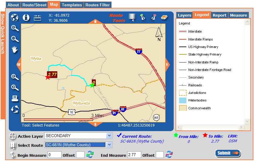
7 Parts of the SLD Display Tools Stick Diagram Mile Readout Slider Bar Scale Change Data Display
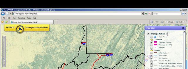
8 West Virginia SLD-Web Portal Concurrent with building and refining LRS framework Will be incrementally enhanced as business processes become more sophisticated Combined with a GIS Web Framework deliverable as first integrated application Designed to be integrated with videologs, project management system, other applications
9
10 Enterprise GIS-based Web Portal
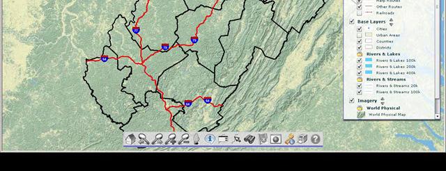
11 Current Available Data Items Grade Width Pavement Width Number of Lanes Speed Limits Surface Type AADT Designated Truck Routes Special System National Highway System WV Legal Functional Class NHFS Functional Class HPMS Sample Data Sections Federal Aid System HPMS Data STIP Project Tracking System Data
12 Project Timeframe Phase 1 completed early 2009 Major functionality ArcIMS used for Web Portal Deployment on GeoDecisions environment Phase 2 completed early 2010 Additional functionality (incl. enhanced printing, more route selection options) More map and data layers ArcGIS Server upgrade for Web Portal Deployment on WVDOT production server, training, documentation, etc.

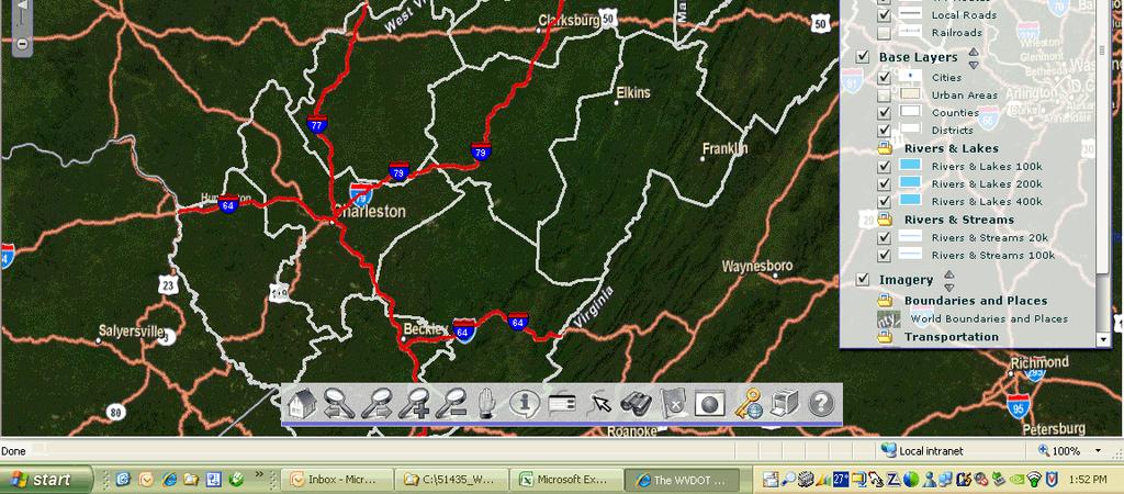
13 Main Portal Interface

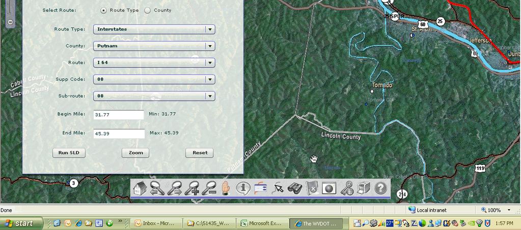
14 Route Selection Environment

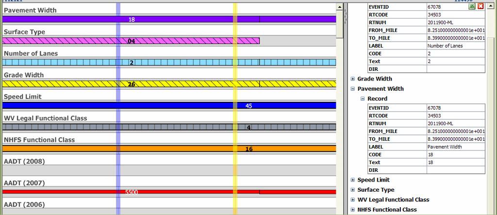
15 SLD Display


16 Concurrent Routes

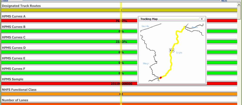
17 Tracking Map


18 Print to PDF, Export Data to Excel
19
20 Phase 3 Enhancements and Videologs Integration Begins early 2010 Integrate with videologs viewer Additional enhancements: Continued improvements to map symbology Changes/improvements to imagery/caching environment Support multiple SLD route displays Add ability for network walking Additional data layers for SLD
21
22 GeoDecisions DOT SLD Projects Application design, code components have been able to be shared and reused among states VT NH ME PA WV VA


23 Examples from Other States GeoDecisions
24 Impacts of WVDOT Project So Far Upgrading database and LRS at same time as conducting project difficult, but has helped more effectively identify and fix problems and incomplete data Planning for and implementation of new datasets (i.e., new videologs) has been promoted and coordinated Ideas for new layers, uses have been readily apparent
25 Contacts and Questions Marshall Burgess WVDOT Geospatial Information Division (304) Don Kiel GeoDecisions (814)
Project Update. Roads and Highways Implementation. Emiko Hori. West Virginia Department of Transportation
 Roads and Highways Implementation at WVDOT Project Update Emiko Hori Geospatial Transportation Information (GTI) Section Geographic Information System (GIS) Unit Agenda 1. Development History 2. Roads
NYSDOT Roadway Inventory. Both On and Off the State System
 NYSDOT Roadway Inventory Both On and Off the State System 1 2 NYSDOT Highway Data Services Bureau Highway Data Traffic Monitoring Pavement Data Inventory of public roads, incl. LHI Systems designations
Adaptation of HERS-ST Models for the South Carolina Interactive Interstate Management System
 Adaptation of HERS-ST Models for the South Carolina Interactive Interstate Management System presented to the Transportation Research Board HERS Modeling and Data Integration Conference presented by William
INDUSTRY. Transportation
 INDUSTRY Transportation Solutions Keeping people and products moving safely and efficiently In a world of constant change, keeping people and products moving safely and efficiently is a complex, unrelenting
Location-driven business at the
 Location-driven business at the Utah Department of Transportation Jeff Saunders Farallon Geographics, Inc. Senior Geodatabase Developer Dan Paske Utah Department of Transportation Oracle DBA Today s Goals
Office of Transportation Data (OTD)
") Office of Transportation Data (OTD) Paul Tanner State Transp o rtatio n D ata A d m inistrato r Presentation Objectives Why do we collect data? State & Federal Code Requirements Who collects the data?
Office of Transportation Data (OTD) Paul Tanner State Transp o rtatio n D ata A d m inistrato r Presentation Objectives Why do we collect data? State & Federal Code Requirements Who collects the data?
Esri Roads and Highways An Introduction. Nathan Easley Rahul Rakshit
 Esri Roads and Highways An Introduction Nathan Easley Rahul Rakshit Roads and Highways Linear Referencing for the Transportation Enterprise GIS-enabled LRS platform LRS management LRS editing & maintenance
OPEN DATA & PROJECT TRACKER. Michael Chamberlain TPP, Data Management
 OPEN DATA & PROJECT TRACKER Michael Chamberlain TPP, Data Management October 11, 017 Table of contents 1 People 3 Attributes 4 3 Locations 5 4 Systems 6 5 Reports 7-8 6 Applications 8-13 7 Closing 14 Data
RIDOT S Statewide Roadway and Asset Data Collection Project
 RIDOT S Statewide Roadway and Asset Data Collection Project ESRI User Conference 2017 Rafiq Basaria, DTS; Daniel Behnke DTS, Shane White, RIDOT Accent image here Primary Image here What is MIRE? Recommended
Keeping people and products moving safely and efficiently
 Solutions for Transportation 2 Keeping people and products moving safely and efficiently In a world of constant change, keeping people and products moving safely and efficiently is a complex, unrelenting
LRS Data Exchange between Esri R&H and AgileAssets Asset Management System in West Virginia
 LRS Data Exchange between Esri R&H and AgileAssets Asset Management System in West Virginia Yueming Wu, Ph.D., GISP GIS Manager Chuck Larson, P.E., PMP Principal Consultant April 7, 2016 Agenda Background
Integrating MAP-21 Asset Management Data Using Esri s Roads and Highways. Imagine the result
 Integrating MAP-21 Asset Management Data Using Esri s Roads and Highways Imagine the result 1 17 2012 October ARCADIS 2014 Presenters David Ward Project Manger and Principal Architect for AzDOT Roads and
Automated Permitting and Routing for OS/OW. GIS-T, 2010 Session Jay Adams - Oklahoma DOT
 Automated Permitting and Routing for OS/OW GIS-T, 2010 Session 4.3.1 Jay Adams - Oklahoma DOT Agenda Business Problem Project Background and Goals High-Level Needs Project Approach Expected Benefits Solution
ArcGIS for Transportation. Tom Brenneman, Gary Waters
 ArcGIS for Transportation Tom Brenneman, Gary Waters ArcGIS for Transportation A product for Esri s transportation customers A series of useful maps and apps focused on transportation Organized into modules
Esri Roads and Highways Solution Overview. Eric Floss Transportation Practice Manager
 Esri Roads and Highways Solution Overview Eric Floss Transportation Practice Manager Agenda Esri LRS Solution Briefing Advanced Linear Referencing Support User Interface Experience Open Discussion GIS
Florida Department of Transportation 605 Suwannee Street Tallahassee, FL
 RICK SCOTT GOVERNOR Florida Department of Transportation 605 Suwannee Street Tallahassee, FL 32399-0450 MIKE DEW SECRETARY REQUEST FOR INFORMATION (RFI) from the Florida Department of Transportation INTRODUCTION
GIS-T 2016 State and Local Project Planning GIS is the Key to Success
 GIS-T 2016 State and Local Project Planning GIS is the Key to Success Dr. Yueming Wu, GIS Manager West Virginia DOT Nate Reck, Gov t Solutions Director GeoDecisions Topics/Discussions Statewide Trans.
Presented by John Hudler Geospatial Group Leader Office of Transportation Data Georgia Department of Transportation
 Presented by John Hudler Geospatial Group Leader Office of Transportation Data Georgia Department of Transportation Collection, Quality Assurance and Reporting of the States roadway and transportation
Innovations in establishing priorities for roadway maintenance & capital projects April 16, Presented by: Chris McConn
 Innovations in establishing priorities for roadway maintenance & capital projects April 16, 2012 Presented by: Chris McConn Identifying a need Our client is one of the top 5 largest cities in the country
GENERAL INTEREST ROADWAY DATA
 Approved: Effective: March 23, 2016 Office: Transportation Statistics Topic No.: 525-020-310-j Department of Transportation PURPOSE: GENERAL INTEREST ROADWAY DATA This procedure establishes Districts and
Roadway Data Extraction Technical Assistance Program (RDETAP) Traffic Safety Conference College Station, June 2016
 Traffic Safety Conference College Station, June 2016") Roadway Data Extraction Technical Assistance Program (RDETAP) Traffic Safety Conference College Station, June 2016 Overview Project motivation and objectives MIRE-MIS Program RDETAP Project Overview of
Roadway Data Extraction Technical Assistance Program (RDETAP) Traffic Safety Conference College Station, June 2016 Overview Project motivation and objectives MIRE-MIS Program RDETAP Project Overview of
April 21, 2015 GIS-T Conference
 April 21, 2015 GIS-T Conference 1 Introductions Don Burris Vice President, Government Solutions Certified GIS Professional Raghunath Madduri Lead Solutions Architect & Project Manager ESRI Certified Enterprise
One Maryland One Centerline. GIS-T 2014 May 7, 2014
 One Maryland One Centerline GIS-T 2014 May 7, 2014 Current Road Centerlines in Maryland SHA maintains a statewide centerline Supports HPMS program Represents state and local roads Capturing dual carriageways
Workflow for Publishing LRS Based Road Network Data. Yueming Wu, Ph.D., GISP GIS Manager West Virginia Department of Transportation
 Workflow for Publishing LRS Based Road Network Data Yueming Wu, Ph.D., GISP GIS Manager West Virginia Department of Transportation Agenda Introduction Workflow for Publishing LRS Data Lessons Learned Near
New Jersey s Enhanced Road Centerline Data Model 2015 GIS T Conference April 21,2015
 2015 GIS T Conference April 21,2015 New Jersey s Enhanced Road Centerline Data Agenda Background & Data Overview Data Maintenance Challenges Future Improvements Q&A Background NJDOT s LRS Overview All
All Roads Do Not End at the State Line: Methodologies for Enabling Geodata Sharing Across Boundaries
 All Roads Do Not End at the State Line: Methodologies for Enabling Geodata Sharing Across Boundaries presented to 22 nd Geospatial Information Systems for Transportation Symposium presented by Julie Chizmas,
New Jersey Turnpike Authority Utility Management System May 6, 2013
 Creating Value Delivering Solutions New Jersey Turnpike Authority Utility Management System May 6, 2013 Presentation Agenda Introduction Utility Challenges System Approach Requirement Gathering Application
Katherine Smyth Solution Engineer
 Architecting the ArcGIS Platform: Best Practices Katherine Smyth Solution Engineer You wouldn t build a house without a blueprint - Warren Peterson So don t build your life GIS without one either! - Warren
RIDOT S Statewide Roadway and Asset Data Collection Project
 RIDOT S Statewide Roadway and Asset Data Collection Project GIS-T Conference 2017 Shane White Rhode Island DOT; Daniel Behnke DTS Accent image here Primary Image here RDIP Technical Assistance Started
The ipems MAP-21 Module
 The ipems MAP-21 Module Producing the information you need from the National Performance Management Research Data Set (NPMRDS) January 2015 Innovation for better mobility Use the ipems MAP-21 Module to
Roadway Data Extraction Technical Assistance Program (RDETAP)
") Roadway Data Extraction Technical Assistance Program (RDETAP) 41 st International Forum on Traffic Records and Highway Information Systems October 2015 Overview Project motivation and objectives MIRE MIS
Roadway Data Extraction Technical Assistance Program (RDETAP) 41 st International Forum on Traffic Records and Highway Information Systems October 2015 Overview Project motivation and objectives MIRE MIS
The Role of PMS in the DOTD Decision Making Process
 The Role of PMS in the DOTD Decision Making Process Christophe N. Fillastre, P.E. CE Louisiana Department of Transportation and Development Section 21, Management Systems and Data Collection Pavement Management
TRANSPORTATION RESEARCH BOARD. Spatial Modeling for Highway Performance Monitoring System Data: Part 1. Tuesday, February 27, :00-4:00 PM ET
 TRANSPORTATION RESEARCH BOARD Spatial Modeling for Highway Performance Monitoring System Data: Part 1 Tuesday, February 27, 2018 2:00-4:00 PM ET The Transportation Research Board has met the standards
Esri Roads and Highways An Introduction
 Esri International User Conference San Diego, California Technical Workshops July 24, 2012 Esri Roads and Highways An Introduction William Isley Majunu Seran Agenda Product Overview Desktop - Demo: Network
DelDOT s. Online Resource. Information. For. Network. Mapping
 DelDOT s Information Network For Online Resource Mapping What is INFORM? Information Network For Online Resource Mapping DelDOT s s Web-based based GIS Application Centralized Source for DelDOT GIS Data
Lessons Learned: Development of a GIS based Landslide Hazard Management System
 Lessons Learned: Development of a GIS based Landslide Hazard Management System By Wael Zatar and Paulus Wahjudi (Marshall University) Lawrence Douglas and Hussein Elkhansa (WVDOT) Geohazards Forum August
Using GIS to Analyze Crash Data in the I-95 Corridor
 Using GIS to Analyze Crash Data in the I-95 Corridor presented to GIS-T Symposium 2008 presented by Bruce D. Spear Cambridge Systematics, Inc. March 18, 2008 Transportation leadership you can trust. Presentation
Montana DOT Strategic Enterprise Architecture Presentation to 2016 IHEEP Annual Conference. September 12, 2016
 Montana DOT Strategic Enterprise Architecture Presentation to 2016 IHEEP Annual Conference September 12, 2016 Introductions Jack Dartman Application Development Supervisor and Enterprise Architect MDT
NYSAMPO Association GIS Working Group Friday, May 23, 2014
 NYSAMPO Association GIS Working Group Friday, May 23, 2014 Participating: A/GFTC Kate Mance CDTC Teresa LaSalle ECTC Mike Perry GTC Chris Tortora HOCTS Jeff Quackenbush, Erin Tylutki NYMTC Munnesh Patel
Using GIS to Support Multi-year Pavement MR&R Need Analysis
 Using GIS to Support Multi-year Pavement MR&R Need Analysis Yichang(James) Tsai, Ph.D., P.E. Bo Gao, Ph.D. Candidate Georgia Institute of Technology Bryant Poole, P.E. JT Rabun, P.E. Georgia Department
ArcGIS for Emergency Management 1:00 2:15pm
 Esri Southwest User Conference September 17-19, 2012 Denver, Colorado ArcGIS for Emergency Management 1:00 2:15pm Jeff Baranyi jbaranyi@esri.com @GISPublicSafety 303-449-7779 Agenda Overview of ArcGIS
FDOT State Safety Office History, Accomplishments & Planned FHWA Funded Efforts. Presenters: Kathryn Waters & Joseph Santos July 29, 2015
 FDOT State Safety Office History, Accomplishments & Planned FHWA Funded Efforts Presenters: Kathryn Waters & Joseph Santos July 29, 2015 Welcome & Introductions Name Organization Your Role & Responsibility
GIS-T Symposium 2017 PennDOT s Maintenance-IQ: How Has It Been Used to Better Operations
 GIS-T Symposium 2017 PennDOT s Maintenance-IQ: How Has It Been Used to Better Operations Matthew Long, GIS and Transportation Planning Specialist PennDOT Office of Planning and Programming Nate Reck, Gov
Data Driven Results: North Carolina s Strategic Prioritization Process through SPOT On!ine. NCDOT Strategic Prioritization Office April 4, 2016
 Data Driven Results: North Carolina s Strategic Prioritization Process through SPOT On!ine NCDOT Strategic Prioritization Office April 4, 2016 Agenda Why We Prioritize Background Strategic Investments
A GIS Methodology to Map Routes from a Truck Permit Database Utilizing a Linear Reference System and Network Analysis
 Dayan et al. 0 0 0 0 0 A GIS Methodology to Map Routes from a Truck Permit Database Utilizing a Linear Reference System and Network Analysis Sinaya Dayan M.S. Geospatial Analyst Rahall Transportation Institute
P274 Transportation Information System. GIS-T T 2004 March 28-31, 2004 Dan Ross, Mn/DOT Project Manager Jim Tucker, Bentley Project Manager
 P274 Transportation Information System GIS-T T 2004 March 28-31, 2004 Dan Ross, Mn/DOT Project Manager Jim Tucker, Bentley Project Manager Outline Scope of Work Architectural Goals Architecture Scalability
Powerful Integration of GIS, Asset Mgt, Work Order Mgt, CRM, Pavement Mgt, and Related Technology - You Can Have it all Without Selling Your Soul!
 Powerful Integration of GIS, Asset Mgt, Work Order Mgt, CRM, Pavement Mgt, and Related Technology - You Can Have it all Without Selling Your Soul! Ramzi Bannura, GISP, MBA GeoSpatial Programs Manager DPW
Utilizing Transportation Data for Low Cost Safety Improvements
 Utilizing Transportation Data for Low Cost Safety Improvements Samuel Sturtz Transportation Planner Iowa Department of Transportation samuel.sturtz@dot.iowa.gov Photo Credits: Ken West- Kenneth G. West
report final Decennial Model Update Executive Summary Contra Costa Transportation Authority Cambridge Systematics, Inc.
 final report prepared for Contra Costa Transportation Authority prepared by with Dowling Associates Caliper Corporation June 2003 Table of Contents 1.0 Introduction... ES-1 2.0 Data Development... ES-5
Ian Kidner, GISP GIS Systems Administrator Office of Technical Services
 / Ian Kidner, GISP GIS Systems Administrator Office of Technical Services Ian.kidner@dot.ohio.gov 614-752-5743 TIMS Vision Provide Easy & Reliable Access to Information Data Consistency Enables Decision
REQUIREMENTS WEBINAR FEBRUARY 20, :00 2:30 P.M.
 ENHANCED NATIONAL HIGHWAY SYSTEM AND REQUIREMENTS WEBINAR FEBRUARY 20, 2013 1:00 2:30 P.M. Webinar Housekeeping Tips There is a designated time at the end of the presentation for questions and answers.
EXHIBIT A SCOPE OF SERVICES: ROADWAY DESIGN SUPPORT CONSULTANT
 EXHIBIT A SCOPE OF SERVICES: ROADWAY DESIGN SUPPORT CONSULTANT I. PURPOSE The Department requires professional engineering and data analysis Consultant services to support the Roadway Design Office with
Mountain View County Local Road Management Plan
 Mountain View County Local Road Management Plan Joey Sherstabetoff, P.Eng. Amec Foster Wheeler Environment & Infrastructure 2015 RoaData Conference Red Deer, Alberta Thursday, January 22 nd, 2015 Introduction
Enterprise GIS Projects: Challenges and Solutions
 Enterprise GIS Projects: Challenges and Solutions Anil K. Jayavarapu ABSTRACT. Enterprise GIS projects are complex. These projects involve coordination and communications between multiple parties. These
Clinton Johnson Solution Architect Patterns & Practices
 Architecting the ArcGIS Platform: Best Practices Clinton Johnson Solution Architect Patterns & Practices Patterns & Practices Solution Architects Amplify customer success by offering strategic guidance,
NJDOT: Asset Management Strategies and Tools
 NEW JERSEY DEPARTMENT OF TRANSPORTATION NJDOT: Asset Management Strategies and Tools Wednesday, October 1, 2014 Afternoon Session (1:45pm 2:30pm) Presenters Michael Castaldo New Jersey Department Of Transportation
PennDOT s Statewide Operations Strategy
 Doug Tomlinson, P.E. Pennsylvania Department of Transportation Bureau of Highway Safety and Traffic Engineering PennDOT s Statewide Operations Strategy Matt Schiemer, P.E. GeoDecisions Overall Strategy
Developing a One Stop ArcIMS Application for High Accident Location (HAL) Management
 Management") Developing a One Stop ArcIMS Application for High Accident Location (HAL) Management March 28, 2007 Charlie Jones Darin Herle Agenda About the Charlotte DOT CDOT Traffic Safety Section Application needs
Developing a One Stop ArcIMS Application for High Accident Location (HAL) Management March 28, 2007 Charlie Jones Darin Herle Agenda About the Charlotte DOT CDOT Traffic Safety Section Application needs
Model Inventory of Roadway Elements (MIRE) GIS-T Annual Conference March 30, Robert Pollack FHWA
 GIS-T Annual Conference March 30, Robert Pollack FHWA") Model Inventory of Roadway Elements (MIRE) GIS-T Annual Conference March 30, 2011 Robert Pollack FHWA What is MIRE? Model Inventory of Roadway Elements Listing of roadway and traffic elements critical
Model Inventory of Roadway Elements (MIRE) GIS-T Annual Conference March 30, 2011 Robert Pollack FHWA What is MIRE? Model Inventory of Roadway Elements Listing of roadway and traffic elements critical
GIS USE IN PAVEMENT MARKING AND SIGN MANAGEMENT: AN INTEGRATED APPROACH
 GIS USE IN PAVEMENT MARKING AND SIGN MANAGEMENT: AN INTEGRATED APPROACH Omar Smadi 1, Zachary Hans 2, and Neal Hawkins 3 ABSTRACT Geographic information system (GIS) technology is a key component of all
Midcon August Presenters: Joseph Drahos and Shawn Blaesing-Thompson
 Midcon August 2015 Presenters: Joseph Drahos and Shawn Blaesing-Thompson Introduction Pavement Marking Management Task Force Look at most effective use of allocated paint program dollars Almost $7 million
THE HIGHWAY SAFETY MANUAL
 THE HIGHWAY SAFETY MANUAL AASHTO Subcommittee on Design June 16, 2006 1 Overview of Presentation Purpose of the Highway Safety Manual Highway Safety Manual Contents Challenges Ahead 2 3 Is this road safe
Continuing Services Contract for Statistics Traffic Data Collection and Analysis. FM No.:
 Continuing Services Contract for Statistics Traffic Data Collection and Analysis I. Purpose FM No.: 430257-3-12-01 The main objectives of this contract are to provide professional and technical services
How to Utilize Your Data to Provide Information to Decision Makers in Traffic Safety ATSIP August 2nd
 How to Utilize Your Data to Provide Information to Decision Makers in Traffic Safety 2011 ATSIP August 2nd Presentations Building Data Warehouses and Using Cubes and Dimensions to Aggregate Data for Fast
EXPONARETM. Connecting people to location-based information through a map-enabled portal.
 EXPONARETM Connecting people to location-based information through a map-enabled portal. Exponare is uncomplicated and easy to understand, enabling staff to work more efficiently by displaying the map,
Designing and Implementing a GIS- Centric Pavement Management System for the City of Alexandria, VA
 Designing and Implementing a GIS- Centric Pavement Management System for the City of Alexandria, VA Transmap Corporation 614-481-6799 (office) Howard Luxhoj, P.E. President and CEO hluxhoj@transmap.com
Supporting Transportation
 Maryland s egis Program: Supporting Transportation Professionals and the Public Maryland State Highway Administration GIS at Maryland State Highway Administration GIS falls under the Office of Planning
RESEARCH RESULTS DIGEST July 1999 Number 242
 IDAHO TRANSPORTATION DEPARTMENT RESEARCH LIBRARY Natiiii1 CooperatTè Highway Research Program N RESEARCH RESULTS DIGEST July 1999 Number 242 Area: IA Planning and Administration, Energy and Environment,
Urban Arterial Roads Pavement Data Collection. October 23, 2012 Todd M. Halacy, P.E. VDOT Local Assistance Division
 Urban Arterial Roads Pavement Data Collection October 23, 2012 Todd M. Halacy, P.E. VDOT Local Assistance Division Presentation Topics Background Information: CTB Subcommittee & Local Government Workgroup
Anchorage Regional ITS Architecture Update: Implementationn Plan
 Anchorage Regional ITS Architecture Update: Implementationn Plan June 2015 Revision History Rev. # Date Author(s) QC Notes: Changes & Affected Pages V 0.0 May 27, 2015 L. Jacobson E. Ehlinger Draft for
Assembling MIRE Data. The Vermont Experience. Vermont Agency of Transportation (VTrans) Mapping Section
 Mapping Section") Assembling MIRE Data The Vermont Experience A look into the development of GIS-based intersection data Vermont Agency of Transportation (VTrans) Mapping Section March 20, 2018 Embarking on the Task of
Assembling MIRE Data The Vermont Experience A look into the development of GIS-based intersection data Vermont Agency of Transportation (VTrans) Mapping Section March 20, 2018 Embarking on the Task of
PAMS: Leveraging a GIS-Based Pavement Assessment and Management System to Validate and Justify Roadway Project Formulation
 PAMS: Leveraging a GIS-Based Pavement Assessment and Management System to Validate and Justify Roadway Project Formulation AASHTO GIS for Transportation Symposium May 7, 2014 Candice Ottley-Francois, PMP,
PennDOT s Road Closure Reporting System ( )
") PennDOT s Road Closure Reporting System ( ) Doug Tomlinson, P.E. PennDOT Bureau of Highway Safety and Traffic Engineering Nate Reck, Lead Developer GeoDecisions How RCRS Came About Originated by PennDOT
PennDOT s Road Closure Reporting System ( ) Doug Tomlinson, P.E. PennDOT Bureau of Highway Safety and Traffic Engineering Nate Reck, Lead Developer GeoDecisions How RCRS Came About Originated by PennDOT
IRRIS. White Paper GeoDecisions. Your Eye on Military Logistics and Transportation Security
 IRRIS White Paper 10. 21. 2004 GeoDecisions Your Eye on Military Logistics and Transportation Security Table of Contents 1 Introduction... 3 2 History of IRRIS... 4 3 IRRIS Components... 4 3.1 Geospatial
Updating Virginia s Statewide Functional. Brad Shelton, VDOT Chris Detmer, VDOT Ben Mannell, VDOT
 Updating Virginia s Statewide Functional Classification System Brad Shelton, VDOT Chris Detmer, VDOT Ben Mannell, VDOT July 18, 2013 What is Functional Classification Use of Functional Classification Today
Chapter 1.0 Introduction
 Chapter 1.0 Introduction 1.1 Background Interstate 81 runs from Danbridge, Tennessee to the US/Canada border, connecting the six states of Tennessee, Virginia, West Virginia, Maryland, Pennsylvania, and
May 20, 2015 Russ Dudley VDOT - Local Assistance Division. May 20, 2015 Todd Halacy VDOT - Local Assistance Division
 NHS Performance Metrics: MAP-21 Transportation Performance Management Assessing Pavement and Bridge Condition for the National Highway Performance Program May 20, 2015 Russ Dudley VDOT - Local Assistance
Automated Statewide Highway Intersection Safety Data Collection and Evaluation Strategy
 Automated Statewide Highway Intersection Safety Data Collection and Evaluation Strategy Fan Yang, Ph.D. Candidate Department of Civil and Environmental Engineering, University of Wisconsin-Madison, Madison,
Introduction to ArcGIS for Situational Awareness. Bruce Robinson
 Introduction to ArcGIS for Situational Awareness Bruce Robinson Overview Complete out-of-the-box Data fusion & management capability Serve data to other mapping packages 2D & 3D GIS viewers Applications
NOMINATION FORM. Zip: Phone: 217/ Fax: 217/
 NOMINATION FORM Title of Nomination: GIS Internet Road Construction Application Project/System Manager: Dennis Jones Job Title: Management Systems Manager Agency: Illinois Department of Transpiration Department:
Roadway Intersection Inventory and Remote Sensing
 Veneziano 1 Roadway Intersection Inventory and Remote Sensing David Veneziano Center for Transportation Research and Education Iowa State University ABSTRACT The application of remote sensing to the collection
<Insert Picture Here> Location Intelligence: Delivering Actionable Analysis for Decision Making
 Location Intelligence: Delivering Actionable Analysis for Decision Making Xavier Lopez, Director, Product Management Agenda Some definitions Integrating Business Intelligence within
Draft Final Report on a research project to define a methodology that will help PennDOT take highway safety to the next level.
 Submitted to: PENNSYLVANIA DEPARTMENT OF TRANSPORTATION USING SPATIAL TOOLS TO ANALYZE CRASH AND ROADWAY DATA PROJECT RFQ NO. 06-05 (C08) FINAL REPORT Draft on a research project to define a methodology
Regional Transportation Profile Guidelines. final. report. April tpd.azdot.gov
 final report April 2005 tpd.azdot.gov Regional Transportation Profile Guidelines Arizona Department of Transportation Transportation Planning Division April 2005 Table of Contents 1.0 Introduction... 1-1
Types of Data. Features. Getting Started. Software Suite
 Roadway Asset Management Software Suite 1-2018-US GIS-based Asset Management System Optimize Maintenance Manage Signs Analyze Safety Roadsoft is a software suite designed for collecting, storing, and analyzing
Freight & Modal Data Program. MPOAC Freight Committee Quarterly Meeting January 26, 2017 Sunrise, Florida
 Freight & Modal Data Program MPOAC Freight Committee Quarterly Meeting January 26, 2017 Sunrise, Florida Overview Mission & Goals Freight Data Programs Recent and Upcoming Activities Mission & Goals FDOT
Case Study. ArcGIS Online Launch for. Utilities
 Case Study ArcGIS Online Launch for Utilities We ve published a lot of blog posts on the vision, value proposition and best practices around ArcGIS Online. To showcase the value of embracing these ideas,
ENTERPRISE DREDGE (edredge): A DREDGING BUSINESS PRACTICE ENTERPRISE GIS APPLICATION
: A DREDGING BUSINESS PRACTICE ENTERPRISE GIS APPLICATION") ENTERPRISE DREDGE (edredge): A DREDGING BUSINESS PRACTICE ENTERPRISE GIS APPLICATION L.S. Lillycrop 1 and R. Dopsovic 2 ABSTRACT Implementation and management of US Army Corps of Engineers (USACE) dredging
ENTERPRISE DREDGE (edredge): A DREDGING BUSINESS PRACTICE ENTERPRISE GIS APPLICATION L.S. Lillycrop 1 and R. Dopsovic 2 ABSTRACT Implementation and management of US Army Corps of Engineers (USACE) dredging
Enterprise GIS Defining A Path Forward
 Enterprise GIS Defining A Path Forward Background DOTD acquired topographic mapping responsibility for the state in 2010 by legislative authority Executive management sponsors GIS as enterprise endeavor
SafetyAnalyst. Introduction
 SafetyAnalyst Introduction The SafetyAnalyst software was developed as a cooperative effort between FHWA and participating state and local agencies and was transferred to AASHTO in 2010. SafetyAnalyst
2016 GIS Strategic Plan Update. June 14, 2016
 2016 GIS Strategic Plan Update June 14, 2016 Project Overview Plan developed concurrently with the ITS Strategic Plan Focused on identifying agency-wide location based data needs for the next ten years
Traffic Data Programs at Virginia DOT: 10 plus Years of Innovation
 Traffic Data Programs at Virginia DOT: 10 plus Years of Innovation Presented by Digital Traffic Systems Inc. Mr. Peter Keen peter.keen@dtsits.com NATMEC 2012 Dallas, Texas 6/5/2012 Business Partner Perspective
Benefit Cost Analysis Narrative
 Chicago Region Environmental and Transportation Efficiency Program (CREATE) Grade Separations of: GS21a - Union Pacific and 95 th Street GS11 - Belt Railway Company of Chicago and Columbus Ave. GS 9 -
Using Random Samples to Assess Roadway Condition. Faith Johnson GIS Specialist, NCDOT
 Using Random Samples to Assess Roadway Condition Faith Johnson GIS Specialist, NCDOT North Carolina Highway System 79,600 miles of state maintained roads Interstate: 1,326 Primary: 13,736 Secondary: 64,522
Pavement Management System - A Cross Platform GIS Roads Management Toolkit
 Pavement Management System - A Cross Platform GIS Roads Management Toolkit Gearoid O Riain Managing Director - Compass Informatics goriain@compassinformatics.co.uk compassinformatics.co.uk Abstract MapRoad
Advanced Enterprise Work and Asset Management for Performance-Driven Utilities
 Advanced Enterprise Work and Asset Management for Performance-Driven Utilities Asset & Resource Management (ARM) 2 CGI s Asset & Resource Management (ARM) 2 suite is a solution designed to streamline the
South Carolina DOT Data Driven Intersection Safety Improvements
 South Carolina DOT Data Driven Intersection Safety Improvements Intersection Safety Data Nationwide: 21 % of all fatalities occur at or near intersections, as well as 52 % of all injuries 45 % of all
ADDENDUM NO. 2 DATE: April 17, 2018 RE: BID #: RFP-DOT-17/ SJ BID TITLE: Integrated Roadway Asset Identification System (IRAIS) Solution
 Solution") FLORIDA DEPARTMENT OF TRANSPORTATION Procurement Office 605 Suwannee Street, MS 20 Tallahassee, Florida 32399-0450 Phone: (850) 414-4381 Fax: (850) 414-4951 ADDENDUM NO. 2 DATE: April 17, 2018 RE: BID
FLORIDA DEPARTMENT OF TRANSPORTATION Procurement Office 605 Suwannee Street, MS 20 Tallahassee, Florida 32399-0450 Phone: (850) 414-4381 Fax: (850) 414-4951 ADDENDUM NO. 2 DATE: April 17, 2018 RE: BID
Memo Pavement Investment Guide
 Memo Pavement Investment Guide Date: 03/26/2018 To: District Engineers, Assistant District Engineers for Program Delivery and Maintenance Operations, District Materials Engineers, District Planners From:
Infrared Technology: Its Application and Benefit
 Infrared Technology: Its Application and Benefit Joseph Reiter, P.E. March 2, 2017 CA AZ CO NM TX OK AR LA MO KY AL GA FL VA OH MI VT AK MT NV ME WA OR UT KS ID WY ND SD MN NE WI IA IL IN MS TN SC NC WV