NEW OPPORTUNITY FOR MIDDLESEX COUNTY
|
|
|
- Allen Franklin George
- 6 years ago
- Views:
Transcription


1 Source: RARITAN RIVER LIGHT RAIL NEW OPPORTUNITY FOR MIDDLESEX COUNTY This report studies the viability of a new transit line connecting New Brunswick, New Jersey, to South Amboy, New Jersey. Prepared by: Daniel Turner
2 RARITAN RIVER LIGHT RAIL NEW OPPORTUNITY FOR MIDDLESEX COUNTY PROPOSAL I am proposing the construction of a new passenger light rail line that runs from South Amboy, New Jersey, to New Brunswick, New Jersey, primarily along the right-of-way of the former Raritan River Railroad. The purpose of this rail line would be to transport passengers in and out of New Brunswick, to provide a rail connection to the commuter lines that run out of New Brunswick and South Amboy, and to create a hub for new transit-oriented development (TOD) in Middlesex County. This line would not only enhance transit service in the region but could possibly reduce congestion along Route 18, which runs parallel to the right-of-way. This report will provide a brief history of the Raritan River Railroad, outline the proposed rail line and current demographic and land use conditions along the proposed site, and discuss some potential impacts of light rail in the region. RARITAN RIVER RAILROAD The Raritan River Railroad was a twelvemile railroad that ran from South Amboy, New Jersey, to New Brunswick, New Jersey, between 1888 and The line was primarily used to transport freight between these points and several points inbetween. BACKGROUND The Raritan River Railroad (RRRR) was a short-line railroad that ran freight between South Amboy, New Jersey, and New Brunswick, New Jersey, from 1888 to (Reynolds, 2012) For a brief period in the early twentieth century, the RRRR provided very limited passenger service as well. The RRRR had its best revenue year in 1979 with revenues exceeding $1.9 million. Since its purchase by Conrail in 1981, the former RRRR line has seen steady decline. Currently, only six customers make use of this line. (Reynolds 2012) FIGURE 1 below shows a map of the RRRR from This map illustrates both the spatial layout of the rail line and also the development patterns of the region at that time. Development at that time was concentrated primarily around New Brunswick, Milltown, South River, and South Amboy. 1
.")
3 FIGURE 1- RARITAN RIVER RAILROAD MAP 1947 Source: STUDY AREA The study area consists primarily of the right of way of the old RRRR with extensions into New Brunswick and South Amboy (See FIGURE 2 below). This line splits the center of Middlesex County, running twelve miles in an east-west direction. As will be shown, this area includes a wide variety of land uses and population densities. The proposed extensions to the current right-of-way connect the light rail line with existing commuter rail stations in New Brunswick and South Amboy as well as provide a downtown connection to these locations. The proposed light rail runs through areas with both existing population and area that would allow for managed growth if transit were a viable option in those locations. Currently no fixed guideway transit exists between New Brunswick and South Amboy, making east west travel between these locations reliant on automobile or bus service. 2

4 FIGURE 2 WHY LIGHT RAIL? New Jersey is the densest state in the United States, with nearly 1,200 inhabitants per square mile according to the 2010 U.S. Census. Middlesex County had an even higher population density in this year, with more than 2,422 inhabitants per square mile. This level of density requires planners in the state and county to think about how the transportation system currently functions and how it will function in the future. It also requires planners to be concerned not only with transportation networks but with how those networks relate and connect land uses. New Jersey has developed a variety of responses to these concerns, including the Transit Village Initiative. This initiative is an effort by the New Jersey Department of Transportation (NJDOT) and NJ Transit to develop and redevelop the areas around transit stations, to promote more walkable communities, to encourage more transit use and less automobile use, and to enhance the economic revitalization of downtowns. The reduction of automobile use is a key component of this initiative. With more than 83 percent of New Jersey residents traveling to work by car in 2000 (NJ TRANSIT, 2008) and 42 percent of New Jersey 3
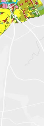
5 roads at or near capacity in 2004 (NJ TRANSIT, 2008), the Transit Village Initiative and other policy initiatives have focused on reducing car use among New Jersey residents. For Middlesex County, the City of New Brunswick represents both a significant cause of congestion and an opportunity for transit-oriented design and a reduction in automobile dependence. According to New Jersey s Long-Range Transportation Plan (2008), in 2000 only 19 percent of New Brunswick s workers lived in the city. (NJ TRANSIT, 2008) With New Brunswick s population expected to rise 40.4 percent by 2030 (compared with 27.8 percent for Middlesex County overall), county and state planners must continue to push for transportation and land use decisions that alleviate automobile dependence while allowing for managed growth. Transit-oriented development (TOD), according to the Transit Cooperative Research Program, aims to increase transit ridership, promote economic development, raise revenues (for transit services), enhance livability, and widen housing choices. (TCRP, 2004) TOD faces many barriers, however. These include financial, zoning, land use patterns, and organizational barriers. (TCRP, 2004) Chief among these barriers in Middlesex County are the land use patterns outside of New Brunswick and the lack of any fixed-route transit in these areas. The old RRRR right-of-way presents an opportunity for Middlesex County to expand its transit options, bolster the opportunities for transit-oriented development, provide better transit connections, and alleviate traffic in and out of New Brunswick. Expanding this line to provide connections to downtown New Brunswick and South Amboy would provide Middlesex County with the kind of transit options and connectivity rarely seen outside of major cities. STUDY AREA DETAILS The land uses around the proposed light rail line offer the opportunity to both serve existing populations and develop new transit-oriented centers. FIGURE 3 below shows the land uses that surround the proposed line by one mile on either side. As is shown in FIGURE 4, these land uses are predominantly residential. Of the dominant eight land uses, 17 percent is high density residential and 9 percent is mixed-urban development. FIGURE 3 shows the spatial distribution of these land uses. Much of the high-density residential development occurs between New Brunswick and South River, with an increasing amount of forested or undeveloped land occurring on the eastern portion of the line near South Amboy. Additional high density residential development is seen in South Amboy. In addition to residential development, a significant amount of commercial development exists within this one-mile buffer area making up 12 percent of the dominant land uses. Forests and shrublands comprise 14 percent of the dominant land uses in the study area buffer. 4


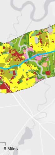


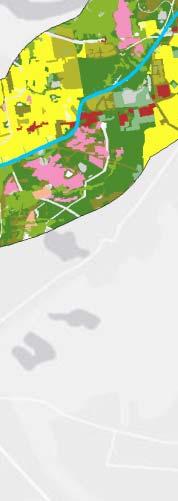


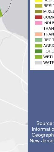
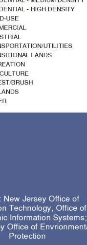
6 FIGURE 3 FIGURE 4 DOMINANT LAND USES Wetlands 9% Forest/Shrublands 14% Residential Low Medium Densityy 29% Agriculture 2% Industrial 8% SOURCE: NEW JERSEY OFFICE OF ENVIRONMENTAL PROTECTION Commercial 12% Mixed Urban 9% Residential High Density 17% 5
7 These land uses represent both present transit ridership potential and latent development potential. Existing population centers are necessary for the development of transit and represent a significant factor in the viability of this light rail line. However, the potential for development along the line offers an equal or greater opportunity to shape future development patterns in New Jersey around transit. It is therefore important to look at both existing conditions and potential for future improvements. New Jersey Transit Transit Score One very helpful tool for determining an area s viability for transit is the Transit Score system used by NJ Transit. (NJ TRANSIT, 2011) This system combines three factors in order to determine transit viability: population density, employment density0f0f1, and zero-car household density. The Transit Score calculation is as follows: Transit Score = [0.41*(Population per acre)] + [0.09*(Jobs per acre)] + [0.74*(Zero car households per acre)] TABLE 1 below displays the range of scores available and how they relate to transit viability. TABLE 1- TRANSIT SCORE INTERVALS Category NJT Range High > 7.5 Medium-High 2.5 to 7.5 Medium 1.0 to 2.4 Marginal 0.6 to 0.9 Low < 0.6 As shown in FIGURE 5 below, the area around the proposed light rail offers a high to medium level of transit viability according to the NJ Transit system. Each transit score range influences the scope of viable transit options. For example, a high score indicates that an area can support all transit options available (rapid transit, commuter rail, express bus, and so on) while a low score area does not support any fixed guideway transit and only limited bus service. The majority of the area around the proposed light rail falls within the high and medium categories and therefore can support light rail transit, according to this system. The average transit score for the census tracts immediately surrounding the proposed line is 4.55, which falls near the middle of the transit supportive medium-high range. The transit score calculated for this report accounts only for existing conditions along the proposed corridor. A projected score can be calculated by using data that extrapolates the future based on trends. For this report, what this score indicates is the level to which fixed guideway transit (i.e., light rail) is a viable option for this corridor. Applying the system used by NJ Transit demonstrates that this corridor represents a viable location for the development of light rail. 1 Some census tracts did not have employment data. The transit score for a few tracts is likely lower than if this data were available. 6

8 FIGURE 5 Extension New Brunswick The RRRR right-of-way extends only to the border of New Brunswick. In order to offer a downtown and transit connection, light rail service must be extended into New Brunswick. This fact represents the most challenging aspect of this proposal. New Brunswick is dense and built out and would require a significant investment in infrastructure. FIGURE 6 below shows one proposal for line extension into downtown New Brunswick. The current right-of-way ends at Georges Road in southern New Brunswick. One option for extending the line would be to bring the rail onto Georges Road as a street car, go onto Sandford Street, and run down Livingston Avenue until its terminus on Neilson Street. There is a large parking lot on the corner of Neilson Street and Liberty Street that could function as a turnaround point. Along with the construction difficulties of implementing light rail on an existing road network, there are also safety concerns. In order to ensure a safe environment, the light rail extension in New Brunswick would require significant infrastructure investment. According to the TCRP report titled Integration of Light Rail Transit into City Street, the most common safety-related problems in this area occurred when pedestrians trespassed on side-aligned light rail rights-of-way when there were no sidewalks, when pedestrians jaywalked across light rail mall rights-of-way, and when there were inadequate pedestrian 7
 In order to mitigate these problems, light rail in New Brunswick would require proper infrastructure and signage, including proper sidewalks, fencing, defined pedestrian pathways,")
9 queuing areas and safety zones. (TCRP, 1995) In order to mitigate these problems, light rail in New Brunswick would require proper infrastructure and signage, including proper sidewalks, fencing, defined pedestrian pathways, adequate queuing spaces, safety islands, and other measures. (TCRP, 1995) FIGURE 6 Extension South Amboy Light rail extension into South Amboy represents a less arduous proposition than extension into New Brunswick. The current right-of-way extends as far as the South Amboy train station (despite no track existing on it), and the area also offers the opportunity for the location of a rail depot. FIGURE 7 below displays the line extension and rail depot, each of which is connected by current rights-of-way. 8
 shows transit supportive density around the proposed line.")
10 FIGURE 7 POTENTIAL RAIL STOPS In order to determine possible locations for rail stops, a population density map on the Census block level was created. This map (see FIGURE 8 below) shows transit supportive density around the proposed line. Possible stop locations were placed in New Brunswick, Milltown, South River, Sayreville, and South Amboy, based on the proximity to dense population centers. In all, six potential stops were determined. This means that each stop is, on average, about two miles from another. Each stop is therefore within a one-mile catchment area. Stops might be added in the future, given the potential for increased development along this line. 9

11 FIGURE 8 MOVING TOD FORWARD Quality transit-oriented planning must establish a connection between transportation and land use not often seen in the United States. Successful TOD must facilitate cooperation between different government agencies and with the public and developers. According to the TCRP report Transit- Oriented Development in the United States, real-estate developers occupy the front lines of TOD, organizing the financial, physical, and human recourses needed to build projects around transit stations. (TCRP, 2004) Developers, however, will only invest in areas where they can reasonably expect a profitable return. Without the existence of transit, developers will build in other more autodependent areas, as they have done in the past. The key components of TOD, therefore, are not only the developers willing to invest in it but the existence of transit to build around. The establishment of a light rail line between New Brunswick and South Amboy will not only provide needed service to existing residences but will also be a hub for future TOD along the line. This will ensure that Middlesex County has a path forward for managing future growth in a way that will mitigate a situation where the transportation network is beyond capacity and is stifling growth. 10
12 REFERENCES NJ Transit New Jersey's Long-Range Transportation Plan. Plan Smarty NJ and URS TRANSIT SCORE: New Jersey's Unique Planning Tool. NJ TRANSIT. Reynolds, Tom E. "History and Current State." Raritan River Railroad. Transit Cooperative Research Program Integration of Light Rail Transit into City Streets. TCRP Report 17. Transit Cooperative Research Program Transit Oriented Development in the United States: Experiences, Challenges, and Prospects. TCRP Report 102 U.S Census Bureau Resident Population Data. 11
IX. STRATEGIC PLAN ELEMENT
 IX. STRATEGIC PLAN ELEMENT The Strategic Plan Element provides the action and implementation plan for the New Brunswick Master Plan. New Brunswick is a fully developed, older urban area in central New
Locally Preferred Alternative. Work In Progress; Subject To Change Without Notice 1
 Locally Preferred Alternative 1 Riverview Corridor Study Area 12 mile study area between Saint Paul and Bloomington. Connects major destinations, neighborhoods and job concentrations. Serves growing and
NEW JERSEY STATE RAIL PLAN NJ TRANSIT New Jersey Department of Transportation
 NJ TRANSIT New Jersey Department of Transportation NJ TRANSIT AND NJDOT TEAM Developing State Rail Plan NJ TRANSIT contract Over the next six months Most planning information already exists Data must be
Overview of Alternatives Analysis
 Red Line/HealthLine Extension Major Transportation Improvement Analysis Greater Cleveland Regional Transit Authority Public Meeting: February 11, 2016 Final Report Overview of Alternatives Analysis Public
Transit Oriented Development Study
 Federal Way Link Extension Transit Oriented Development Study Table of Contents Executive Summary ES 1 Chapter 1: Introduction.. 1-1 Chapter 2: Methodology. 2-1 Chapter 3: Project Overview 3-1 Chapter
Nashville Southeast Corridor High-Performance Transit Alternatives Study. Final Report
 Nashville Southeast Corridor High-Performance Transit Alternatives Study Final Report August 2007 - Nashville Southeast Corridor Executive Summary I. Introduction The southeast corridor is a 30 mile long
Lesson 2. Principles of. Transportation. Land Use 2-1
 Lesson 2 Principles of Transportation & Land Use 2-1 Learning Outcomes Explain transportation s impact on land use and development patterns, including historical growth patterns Explain how land use patterns
Final Land Use and Development Opportunities Report 5.0 Environmental Impact/Environmental Consequences
 Figure 5-6. Century City 1/4-Mile Station Area August 16, 2010 Page 5-14 Figure 5-7. Wilshire/Westwood 1/4-Mile Station Area August 16, 2010 Page 5-15 Alternative 1 would be constructed underneath existing
Summary of transportation-related goals and objectives from existing regional plans
 SMTC 2050 Long Range Transportation Plan Appendix A: Summary of transportation-related goals and objectives from existing regional plans SMTC 2050 Long Range Transportation Plan Summary of transportation-related
Contents i Contents Page 1 A New Transportation Plan Community Involvement Goals and Objectives... 11
 Contents i Contents 1 A New Transportation Plan... 1 Why develop a new plan?... 1 What area does the LRTP focus on?... 2 Why is this LRTP important?... 3 Meeting Requirements for Transportation Planning...
APPENDIX A - PLANS AND POLICY REVIEW FEBRUARY 2017
 APPENDIX A - PLANS AND POLICY REVIEW FEBRUARY 2017 DENVERMOVES Transit Denver Moves: Transit APPENDIX A PLANS AND POLICY REVIEW 2035 Metro Vision Regional Transportation Plan (MVRTP) (2011) 2040 Fiscally
City of Brantford Chapter 3 TABLE OF CONTENTS
 Chapter 3 The Land Use & Transportation Connection TABLE OF CONTENTS 3.1 THE LAND USE & TRANSPORTATION LINK... 1 3.2 POPULATION & EMPLOYMENT GROWTH FORECASTS... 3 3.2.1 Proposed Places to Grow Plan Forecasts
2004 FEASIBILITY STUDY UPDATE
 Austin-San Antonio Intermunicipal Commuter Rail District 2004 FEASIBILITY STUDY UPDATE December 2004 EXECUTIVE SUMMARY INTRODUCTION Almost 3 million people in Central Texas, living and working between
2040 LAND USE WORKBOOK February 2017
 040 LAND USE WORKBOOK February 017 S A/C INTRODUCTION SITE SPOTLIGHT: WATERFRONT Through a series of community workshops and online activities in 016, Stockton community members shared their vision for
What is the Transportation Policy Plan (TPP)?
?") Summary What is the Transportation Policy Plan (TPP)? The region s long range transportation plan Includes all modes of transportation: highways, transit, airports, freight, biking, pedestrians Meets the
Summary What is the Transportation Policy Plan (TPP)? The region s long range transportation plan Includes all modes of transportation: highways, transit, airports, freight, biking, pedestrians Meets the
1. Evaluation of route and service alternatives; 2. Tier 1 Environmental Impact Analysis; and 3. Service Development Plan.
 Rail Rail plays a significant role in transportation planning, especially when considering economic development, safety, freight, and intermodal connectivity. Jackson has two rail lines serving the area,
Chapter 4: Transportation and Land Use
 Chapter 4: Transportation and Land Use Transportation and land use together make possible the wide range of destination opportunities in the region. Transportation provides the connections, and, in turn,
Session 61: Regional Transportation Planning
 Session 61: Regional Transportation Planning Freight and Livability/Sustainability Connections 2011 Louisiana Transportation Conference Jocelyn Jones, FHWA Resource Center January 12, 2011 Session Outcomes
South Boston. Transportation Plan. Transportation Planning Division. Virginia Department of Transportation
 2020 Transportation Plan Developed by the Transportation Planning Division of the Virginia Department of Transportation in cooperation with the U.S. Department of Transportation, Federal Highway Administration
FINAL. Sound Transit Long-Range Plan Update Issue Paper S.6: Potential Tacoma Link Extension - East. Prepared for: Sound Transit
 Sound Transit Long-Range Plan Update Issue Paper S.6: Potential Tacoma Link Extension - East Prepared for: Sound Transit Prepared by: Parsons Brinckerhoff Quade & Douglas, Inc. FINAL March 2005 Foreword
3.0 REVIEW OF PREVIOUS STUDIES
 3.0 REVIEW OF PREVIOUS STUDIES This section of the highlights the significant features from previous plans and studies that could impact the development of the I-20 East Transit Initiative. Much of the
CHAIR AND MEMBERS STRATEGIC PRIORITIES AND POLICY COMMITTEE MEETING ON MAY 3, 2017
 TO: FROM: CHAIR AND MEMBERS STRATEGIC PRIORITIES AND POLICY COMMITTEE MEETING ON MAY 3, 2017 KELLY SCHERR, P.ENG., MBA, FEC MANAGING DIRECTOR, ENVIRONMENTAL & ENGINEERING SERVICES AND CITY ENGINEER SUBJECT:
St. Augustine Multimodal Transportation Center Study
 St. Augustine Multimodal Transportation Center Study Expanding Mobility, Tourism, and Economic Development Public Workshop/Open House July 30 th, 2013 Tonight s Goals 1. Provide Project Overview & Deliverables
Riverview Corridor Pre-Project Development Study
 Riverview Corridor Pre-Project Development Study American Society of Civil Engineers - Minnesota May 25, 2016 Work in Progress; Subject to Change 1 History 2000: Major Investment Study (MIS) offered several
Rapid Transit in Winnipeg. Winnipeg TOD Summit November 17, 2014
 Rapid Transit in Winnipeg Winnipeg TOD Summit November 17, 2014 Presentation Overview Rapid Transit (RT) in Winnipeg What is RT? What are our RT plans? Near term Longer term Comments re: TOD OurWinnipeg
EIGHT PLANNING FACTORS
 EIGHT PLANNING FACTORS Under the provisions of SAFETEA-LU, all Metropolitan Planning Organizations (MPOs) are required to consider eight (8) broad planning factors in the development of multi-modal transportation
This document has been developed to provide context to the Board as part of the strategic planning process. Regional development and travel trends
 1 This document has been developed to provide context to the Board as part of the strategic planning process. Regional development and travel trends and forecasts are provided, including population, employment,
TRANSPORTATION RELATIONSHIP TO OTHER ELEMENTS OF THE PLAN AND COUNTY REGULATIONS VISION FOR TRANSPORTATION PLANNING ROAD NETWORK SECTION 7
 TRANSPORTATION Like many growing western counties, Douglas County focuses on one of the most integral elements in land-use planning: transportation. The primary purpose of a transportation network is to
SUBURBAN EDGE COMMUNITY ROLE COUNCIL ROLE ALL COMMUNITIES SUBURBAN EDGE
 Orderly and Efficient Land Use Align land use, development patterns, and infrastructure to make the best use of public and private investment. Plan and stage development for forecasted growth through 2040
King of Prussia Rail Project Frequently Asked Questions - Archive Version: Summer 2018
 - Archive Version: Summer 2018 These frequently asked questions (FAQ) have been developed to help residents, businesses and area stakeholders develop a better understanding of the proposed King of Prussia
AMPO Annual Conference Session: Performance (Part 1) October 18, 2017 Savannah, GA
 October 18, 2017 Savannah, GA") AMPO Annual Conference Session: Performance (Part 1) October 18, 2017 Savannah, GA Introduction: North Jersey Transportation Planning Authority NJTPA Congestion Management Process Study Goals Analysis
AMPO Annual Conference Session: Performance (Part 1) October 18, 2017 Savannah, GA Introduction: North Jersey Transportation Planning Authority NJTPA Congestion Management Process Study Goals Analysis
2030 Transportation Policy Plan SUMMARY PRESENTATION. Land Use Advisory Committee November 15, 2012
 2030 Transportation Policy Plan SUMMARY PRESENTATION Land Use Advisory Committee November 15, 2012 Today s Topics Transportation Policy Plan (TPP) Requirements and Background Current TPP Policies, Issues
Issue Paper on Regional Land Use and Transit Planning (Draft)
") Regional Transit Long-Range Plan Update Issue Paper on Regional Land Use and Transit Planning (Draft) 401 South Jackson Street Seattle, WA 98104-2826 October 2014 Issue Pap er on Region al La nd Use an
Regional Transit Long-Range Plan Update Issue Paper on Regional Land Use and Transit Planning (Draft) 401 South Jackson Street Seattle, WA 98104-2826 October 2014 Issue Pap er on Region al La nd Use an
Rail & Transit Alternatives Analysis. NH Capitol Corridor. Public Scoping Meeting. March 5, 2014
 NH Capitol Corridor Rail & Transit Alternatives Analysis Public Scoping Meeting March 5, 2014 Agenda Study overview National Environmental Policy Act Preliminary alternatives: rail, bus, stations, layover
Cook County Long Range Transportation Plan MULTIMODAL ANALYSIS SUMMARY OF EXISTING CONDITIONS
 MULTIMODAL ANALYSIS SUMMARY OF EXISTING CONDITIONS MAY 28, 2014 OVERVIEW is the second most populous county in the United States with over 5.2 million residents and contains more than half the Chicago
EXECUTIVE SUMMARY REGIONAL TRANSPORTATION PLAN 2050
 EXECUTIVE SUMMARY REGIONAL TRANSPORTATION PLAN 2050 Introduction Goals Policies, and Performance Measures Growth Forecast and Planned Land Use Development Key Recommendations i Executive Summary April
I-26 Fixed Guideway Alternatives Analysis. Transit Talk: ULI Executive Round Table Discussion. Thursday, April 30, :30 AM 1:00 PM
 I-26 Fixed Guideway Alternatives Analysis Transit Talk: ULI Executive Round Table Discussion Thursday, April 30, 2015 8:30 AM 1:00 PM AGENDA 1) i-26alt Project Overview 2) Conceptual Alignments & Modes
TRANSIT SYSTEM SUMMARY REPORT
 Genesee County Shaping our Transportation Future Together 2035 Long Range Transportation Plan TRANSIT SYSTEM SUMMARY REPORT Introduction The Genesee County Transit Technical Report is one of 19 technical
Regional Performance Measures Annual Progress Report TPO Board - 2/4/2016 Presentation by: Chris Wichman, Senior Planner
 2015 TPO Board - 2/4/2016 Presentation by: Chris Wichman, Senior Planner Overview History and definition of performance-based planning & programming Review of 2015 TPO Board Action Requested 2 History
Agenda. Public Input: Results from Open House 1. Evaluation Criteria: FTA and Local Considerations
 Agenda Jackson County Commuter Corridors Alternatives Analysis Stakeholder Advisory Panel Meeting Two 2:30 p.m. November 16, 2011 Kansas City Area Transportation Authority, 1200 E. 18 th, Kansas City,
Transit Demand Analysis
 Transit Demand Analysis Purpose To determine impact on ridership and revenues of any change in service policy. Need to know how demand estimates will be used. May not require an elaborate analysis in many
12 Evaluation of Alternatives
 12 Evaluation of Alternatives This chapter evaluates the effectiveness of the No-Build Alternative and the proposed METRO Blue Line Light Rail Transit (BLRT) Extension project based on the information
4.0 Coordination and Consultation 4.0 Coordination and Consultation
 4.0 Coordination and Consultation 4.0 Coordination and Consultation DART RAIL TO ROWLETT Connecting Communities 4.0 COORDINATION AND CONSULTATION This Chapter provides an overview of the public involvement
NEW JERSEY DEPARTMENT OF TRANSPORTATION. New Jersey Statewide Strategic Freight Rail Plan
 NEW JERSEY DEPARTMENT OF TRANSPORTATION New Jersey Statewide Strategic Freight Rail Plan OVER-ARCHING PROJECT PURPOSE In short, the plan is intended to: Identify Issues That Constrain Freight Rail Operations
ACTIVE TRANSPORTATION ADVISORY COMMITTEE. Memphis MPO March 30, 2015
 ACTIVE TRANSPORTATION ADVISORY COMMITTEE Memphis MPO March 30, 2015 Agenda Welcome & Introductions Announcements and Briefings Livability 2040: Regional Transportation Plan Congestion Management Process
Vanasse Hangen Brustlin, Inc. DRAFT. Appendices. MIS Appendices
 DRFT ppendices MIS 8-05 - ppendices ppendices ugust 005 [THIS PGE INTENTIONLLY LEFT BLNK] DRFT ppendix Tier Detailed Evaluation Tables MIS 8-05 - ppendix ppendix ugust 005 [THIS PGE INTENTIONLLY LEFT BLNK]
Table of Contents. Green Line Extension Project. Draft Environmental Impact Report/Environmental Assessment and Draft Section 4(f) Evaluation
 Evaluation") Table of Contents Acronyms and Abbreviations Secretary s Certificate on the EENF Executive Summary 1 Introduction and Background... 1-1 1.1 Introduction... 1-1 1.2 Project Summary... 1-2 1.3 Permits and
Table of Contents Acronyms and Abbreviations Secretary s Certificate on the EENF Executive Summary 1 Introduction and Background... 1-1 1.1 Introduction... 1-1 1.2 Project Summary... 1-2 1.3 Permits and
Priorities are for AG comment at today's meeting. Four time frames proposed for implementation
 Prioritization Overview Priorities are for AG comment at today's meeting Four time frames proposed for implementation Prioritization Overview Some editing of Principles to read as implementation versus
KNOXVILLE REGIONAL TRANSIT CORRIDOR STUDY
 KNOXVILLE REGIONAL TRANSIT CORRIDOR STUDY April 2013 Alignments Alignments Magnolia Ave Northeast corridor Knoxville Transit Center Hall of Fame Dr Magnolia Ave Prosser Rd. Corridor contains commercial,
Fairmount Line Feasibility Study
 Executive Summary Wednesday October 16, 2002 Prepared for Massachusetts Bay Transportation Authority Planning Department Prepared by KKO and Associates, L.L.C. Two Dundee Park Andover, Massachusetts 01810
Northeast Rail Operations Study (NEROps)
") I-95 Corridor Coalition Northeast Rail Operations Study (NEROps) Phase I Final Report Executive Summary June 2007 Northeast Rail Operations Study (NEROps) Phase I Final Report Executive Summary Prepared
I-95 Corridor Coalition Northeast Rail Operations Study (NEROps) Phase I Final Report Executive Summary June 2007 Northeast Rail Operations Study (NEROps) Phase I Final Report Executive Summary Prepared
TRANSPORTATION AND LAND USE
 TRANSPORTATION AND LAND USE INTRODUCTION The 2020 and 2030 GHG projections estimate that transportation emissions in the unincorporated area will increase considerably in the next two decades. Minimizing
EXAMPLES OF COMPREHENSIVE PLAN POLICIES HOW TO ESTIMATE THE BENEFITS OF THE CTR PROGRAM
 TABLE OF CONTENTS INTRODUCTION... I BACKGROUND OF THE COMMUTE TRIP REDUCTION EFFICIENCY ACT... II MAKING THE CONNECTION BETWEEN COMMUTE TRIP REDUCTION AND THE GROWTH MANAGEMENT ACT... IV CTR PLANNING AND
LAND USE POLICIES BY COMMUNITY DESIGNATION
 137 2040 138 Land Use Policies by Community Designation As discussed earlier in Thrive MSP 2040, the Council assigns a community designation to each city and township. This designation indicates the overall
APPENDIX TRAVEL DEMAND MODELING OVERVIEW MAJOR FEATURES OF THE MODEL
 APPENDIX A TRAVEL DEMAND MODELING OVERVIEW The model set that the Central Transportation Planning Staff (CTPS), the Boston Region Metropolitan Planning Organization s (MPO) technical staff, uses for forecasting
PUBLIC TRANSIT SERVICE OBJECTIVES AND STANDARDS
 PUBLIC TRANSIT SERVICE OBJECTIVES AND STANDARDS 3 Credit: Ozaukee County 3.1 INTRODUCTION To allow a thorough evaluation of the existing transit services offered by Ozaukee County and any alternative transit
FACT SHEETS SAN BERNARDINO COUNTY
 FACT SHEETS SAN BERNARDINO COUNTY WHAT IS THE REGIONAL TRANSPORTATION PLAN/ SUSTAINABLE COMMUNITIES STRATEGY (RTP/SCS) Every four years the Southern California Association of Governments (SCAG) prepares
Park-and-Ride Lot Study
 Park-and-Ride Lot Study Final Report September 2014 [DRAFT] Submitted by In association with Table of Contents Executive Summary... 1 Introduction and Study Objectives... 4 Existing Park-and-Ride Lots
SECTION 4. Citizen s Guide to DEIS
 SECTION 4 Citizen s Guide to DEIS This page intentionally left blank Record of Public Comment on Central Corridor Draft Environmental Impact Statement 51 The Central Corridorx Draft Environmental Impact
Los Angeles County Sustainability Summit Your Community: Smart Growth and Community Development
 Los Angeles County Sustainability Summit Your Community: Smart Growth and Community Development Barbara Dye The South Bay Cities Council Of Governments (SBCCOG) is a joint powers authority of 16 cities
Draft Land Use, Scenario Planning, & Sustainability Technical Report. Summary
 ` Draft Land Use, Scenario Planning, & Sustainability Technical Report Summary Introduction In 2006, the Genesee County Metropolitan Planning Commission (GCMPC) performed an analysis of the past and current
Once known as warehousing and distribution, the process
 Map III-2.3 Proposed Agile Port Industrial Area AGILE PORT INDUSTRIAL AREA PLAN Once known as warehousing and distribution, the process of moving goods to market has evolved dramatically. No longer is
IMPLEMENTING THE PLAN
 IMPLEMENTING THE PLAN SELECTED KEY MESSAGES 1. Protect the Core Functions. Assuming a stable revenue and cost scenario, the financial analysis indicates that there are likely enough resources to cover
Chapter #9 TRAVEL DEMAND MODEL
 Chapter #9 TRAVEL DEMAND MODEL TABLE OF CONTENTS 9.0 Travel Demand Model...9-1 9.1 Introduction...9-1 9.2 Overview...9-1 9.2.1 Study Area...9-1 9.2.2 Travel Demand Modeling Process...9-3 9.3 The Memphis
step-by-step workbook
 future investment in TOD step-by-step workbook introduction A Tool For TOD Transit Oriented Development. TOD. It is an acronym (and a development concept) that is often spoken but seldom accomplished in
DRAFT Scoping Booklet
 DRAFT Scoping Booklet Environmental Impact Statement December 2014 Prepared For: Metropolitan Atlanta Rapid Transit Authority Prepared By: AECOM Atlanta, GA December 2014 Cover Photo Credit: Sinan Sinharoy
Consequences of Sprawl
 Loss of farmland Land conversion and stormwater runoff Water quality and quantity Loss of wildlife habitat Larger carbon footprint Lack of roadway connectivity and access Public health and safety Road
Airports in the Region Case Study
 DESTINATION LINDBERGH: COLLABORATION AND VISION TO MEET SAN DIEGO S MOBILITY NEEDS By Bob Leiter, FAICP, Keith Wilschetz, and Tait Galloway INTRODuCTION Destination Lindbergh was a year-long, comprehensive
CHAPTER NINE: TRANSPORTATION
 CHAPTER NINE: TRANSPORTATION Brookfield s access to the surrounding region and its central location are primary community assets. Maintaining this accessibility and mobility will also be key to the community
S-16: Sounder Rail Extension from Puyallup to Orting
 Project Number S-16 Subarea Pierce Primary Mode Commuter Rail Facility Type Corridor Length 5.7 miles Version ST Board Workshop Date Last Modified 11-25-2015 PROJECT AREA AND REPRESENTATIVE ALIGNMENT SHORT
INTEGRATED MOBILITY PLAN
 Re: Item No. 3 INTEGRATED MOBILITY PLAN Committee of the Whole December 5, 2017 halifax.ca/integratedmobility Presentation Outline Why the IMP Now? Big Transportation Moves in HRM IMP Vision and Transportation
Route 1 Regional Growth Strategy Vision for a Prosperous and Sustainable Future
 Route 1 Regional Growth Strategy Vision for a Prosperous and Sustainable Future NEW JERSEY DEPARTMENT OF TRANSPORTATION AECOM PB Americas Voorhees Transportation Center Weiss Consulting PlanSmart NJ URS
Land Use, Scenario Planning, & Sustainability Technical Report. Summary
 ` Land Use, Scenario Planning, & Sustainability Technical Report Summary Introduction In 2006, the Genesee County Metropolitan Planning Commission (GCMPC) performed an analysis of the past and current
GULF COAST RAIL DISTRICT VISION FOR REGIONAL RAIL
 GULF COAST RAIL DISTRICT VISION FOR REGIONAL RAIL OCTOBER 2014 Cover photographs courtesy of Top left - Mike Bates TABLE OF CONTENTS MISSION... 1 INTRODUCTION... 1 VISION STATEMENT... 1 BACKGROUND... 2
Subarea Mobility Enhancements. 5.1 Transit and Pedestrian Improvements
 Section Five Section 5: Subarea Mobility Enhancements 5.1 Transit and Pedestrian Improvements From the outset of the master planning process, one of the primary goals was to integrate transit and pedestrian-oriented
Green Line Extension EOT. Project Location. Project Purpose. Environmental Impact Report Public Scoping Session
 Green Line Extension Environmental Impact Report Public Scoping Session Somerville High School October 16, 2006 Project Location Green Line Extension Project Purpose Implement enhancements to transit services
Service Routes and Community Transit Hubs: Right Sizing Transit NATIONAL CONFERENCE ON RURAL PUBLIC AND INTERCITY TRANSPORTATION OCTOBER 2-5, 2016
 Service Routes and Community Transit Hubs: Right Sizing Transit NATIONAL CONFERENCE ON RURAL PUBLIC AND INTERCITY TRANSPORTATION OCTOBER 2-5, 2016 Competing with the Auto It is tough to match the convenience
Transportation Concurrency
 2015 Frequently Asked Questions About. Transportation Concurrency Q. What is Transportation Concurrency? A. Transportation Concurrency is both a State law requirement and a City pre-application development
Transportation Concurrency
 2017 Frequently Asked Questions About. Transportation Concurrency Q. What is Transportation Concurrency? A. Transportation Concurrency is both a State law requirement and a City pre-application development
wheaton s future Wheaton s Role in the County
 wheaton s future Wheaton is envisioned as a major mixed-use center for the Georgia Avenue corridor and eastern Montgomery County. It will have regional shopping, culturally diverse retail and entertainment,
MEMORANDUM #4. DATE: November 4, Warrenton TSP Project Management Team. Ray Delahanty, AICP, DKS Associates Kate Petak, EIT, DKS Associates
 MEMORANDUM #4 DATE: November 4, 2015 TO: FROM: SUBJECT: Warrenton TSP Project Management Team Ray Delahanty, AICP, DKS Associates Kate Petak, EIT, DKS Associates Warrenton Transportation System Plan Update
POLK COUNTY TPO Polk County 2060 Transportation Vision Plan Final Report. ADOPTED June 18, 2009
 POLK COUNTY TPO Polk County 2060 Transportation Vision Plan Final Report ADOPTED June 18, 2009 TABLE OF CONTENTS CHAPTER 1 Introduction and Prior Planning Effort...Page 1-1 CHAPTER 2 Population and Employment
SOUTHWEST LRT (METRO GREEN LINE EXTENSION)
") 8 Evaluation of Alternatives This chapter evaluates the effectiveness of the No Build Alternative and the Southwest Light Rail Transit (LRT) Project (the Project) based on the information contained in
8 Evaluation of Alternatives This chapter evaluates the effectiveness of the No Build Alternative and the Southwest Light Rail Transit (LRT) Project (the Project) based on the information contained in
Land Use INTRODUCTION
 Land Use INTRODUCTION The Land Use Element provides the policy context for the Centre Region to achieve its goals for the preservation and future development of rural, suburban, and urban land uses. This
Governor Baldacci s Transportation Bond Proposal
 Governor Baldacci s Transportation Bond Proposal Talking Points Highway and Bridge Investment The lifeblood of the Maine economy $100 HF Bond Maine s Bridges are old and getting older - Nearly 10% are
Appendix C: Scenarios and Future Drivers Impacting Transportation
 Prepared for Washington County Prepared by David Evans and Associates, Inc. 2100 SW River Parkway Portland, Oregon 97201 TABLE OF CONTENTS 1. INTRODUCTION... 2 2. SCENARIOS PLANNING OVERVIEW... 2 3. SCENARIOS
Transit Investment Direction and Plan Introduction. Transportation Advisory Board TPP Workshop August 16, 2017
 Transit Investment Direction and Plan Introduction Transportation Advisory Board TPP Workshop August 16, 2017 Today s Topics - Transit Where are we now, what are the current issues? Where do we want to
Lynnwood Link Extension 2013 Draft EIS Comments and Responses. Page 945
 I-441-001 Thank you for your comments about the importance of the Latvian Center to the Latvian community. Following the Draft EIS, the Sound Transit Board directed Sound Transit to develop a Preferred
Gateway Corridor Transitway
 Locally Preferred Alternative Summary Gateway Corridor Transitway 1 Metropolitan Council, Nov. 12, 2014 Gateway Corridor Transitway Proposed highcapacity transit improvement connecting east metro suburbs
BUS RAPID TRANSIT CORRIDOR
 DOWNTOWN UPTOWN OAKLAND EAST END BUS RAPID TRANSIT CORRIDOR Scoping Booklet for National Environmental Policy Act Review City of Pittsburgh Port Authority of Allegheny County Uptown/Downtown Scoping Meeting
Environmental Setting
 Section 5.2 Environmental Justice This section describes the potential of the proposed changes to the approved project to result in disproportionately high and adverse health or environmental effects on
The development of potential alignment segments was based on the review of:
 5.0 FEASIBILITY ANALYSIS This section summarizes the results of analysis used to determine the feasibility of a Monorail/AGT system in the WILMAPCO region. The section begins with a discussion of the identification
Category 3, BART Capacity, Access and Parking Improvements. Contra Costa Transportation Authority STAFF REPORT Page 2 of 5 The Authority directed staf
 Meeting Date: Subject Summary of Issues Recommendations Financial Implications Options Attachments Changes from Committee Development of a Potential Transportation Expenditure Plan (TEP) Review and Discussion
Transportation and Utilities
 4 Section 4 Transportation and Utilities 4.0 Introduction Transportation and utility systems are essential to accommodate and support development proposed in the Future Land Use Map. The following pages
C-11: Madison Street BRT
 Project Number C-11 Subarea North King Primary Mode BRT Facility Type Corridor Length 2.3 miles Version ST Board Workshop Date Last Modified 11-25-2015 PROJECT AREA AND REPRESENTATIVE ALIGNMENT SHORT PROJECT
Policy Research CENTER
 Connecting Demand Management and Economic Development Activities TRANSPORTATION Policy Research CENTER Recent research into employer-based demand management strategies highlighted the fact that most business
PAJARO COMMUNITY PLAN PRINCIPAL FINDINGS Draft
 PAJARO COMMUNITY PLAN PRINCIPAL FINDINGS Draft 7-2-02 Community Vision Pajaro s future vision is a healthy balanced community in context with agricultural uses and the culturally diverse character of the
Shaping Private Development/ Growth Management
 Shaping Private Development/ Growth Management What are the social consequences of sprawl? Can private development be controlled to manage growth on the regional scale? What is gained by trying to manage
Connecting Cleveland 2020 Citywide Plan TRANSPORTATION & TRANSIT
 Connecting Cleveland 2020 Citywide Plan TRANSPORTATION & TRANSIT TRANSPORTATION & TRANSIT OVERVIEW Like many cities that developed in the 19 th and early 20 th centuries, Cleveland grew because of its
Transportation, Mobility and Access
 Transportation, Mobility and Access In The City of North Vancouver A Discussion Paper Prepared to Inform the Direction of a New Official Community Plan 2021 & Beyond Dragana Mitic Assistant City Engineer