PRE-FIRE PLANNING. Pre-Attack Mapping by Fire Captain Greg Alex Pre-Fire Engineer / GIS Coordinator San Luis Obispo County
|
|
|
- Penelope Sullivan
- 6 years ago
- Views:
Transcription
1
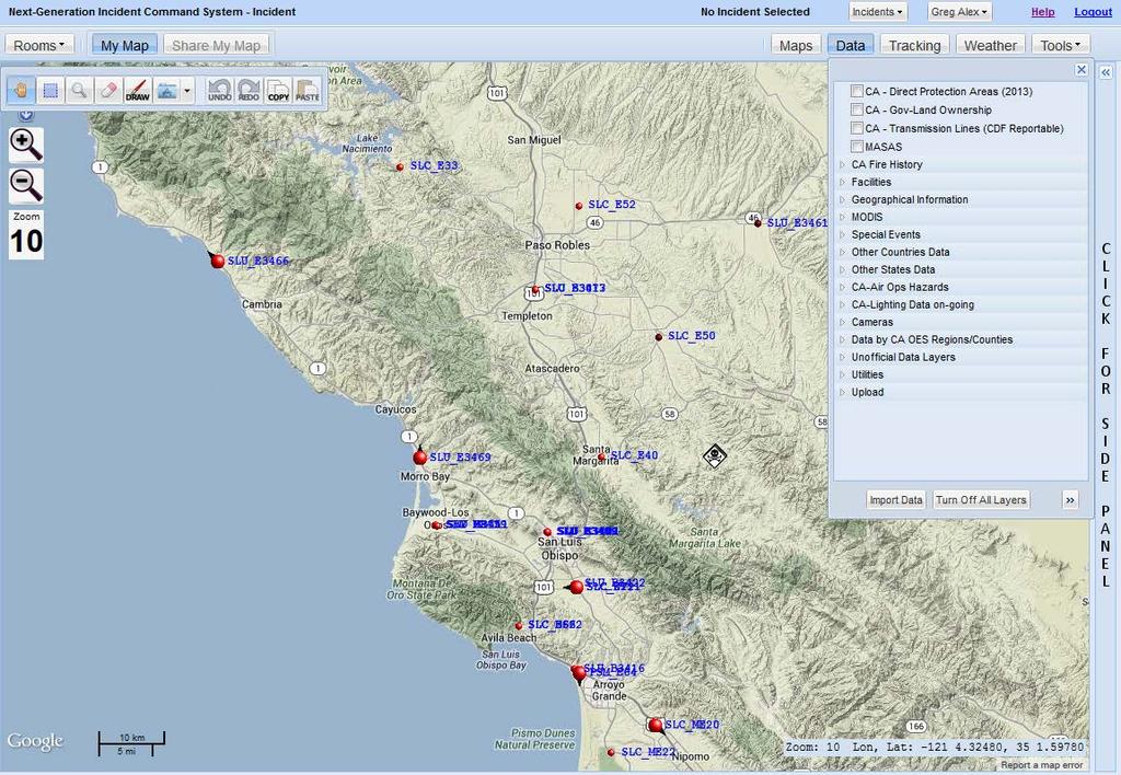
2 PRE-FIRE PLANNING Pre-Attack Mapping by Fire Captain Greg Alex Pre-Fire Engineer / GIS Coordinator San Luis Obispo County
3

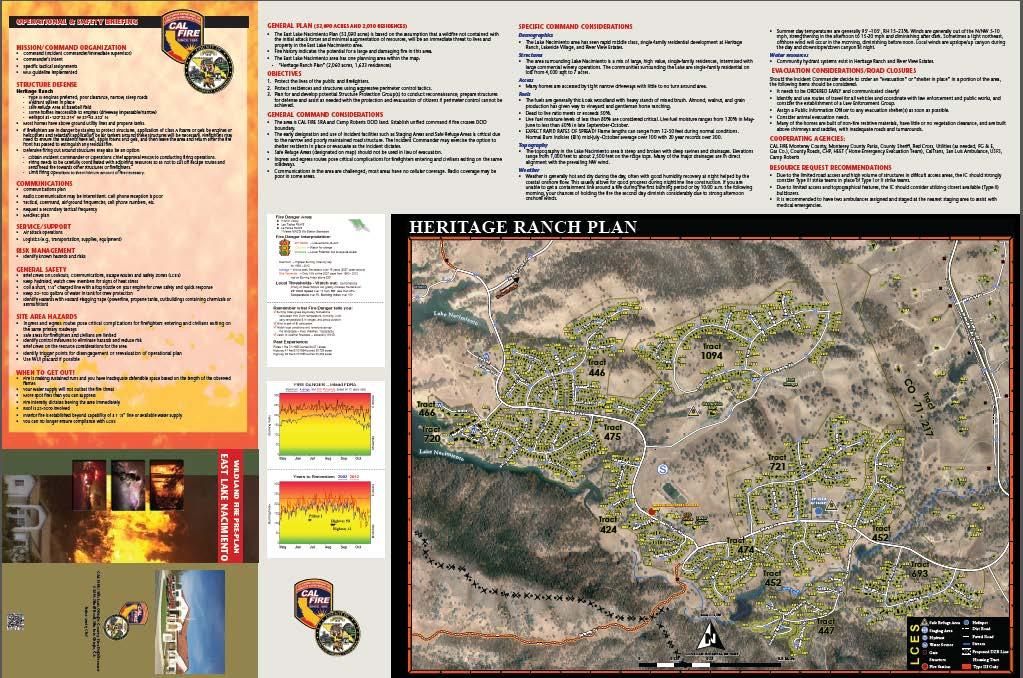
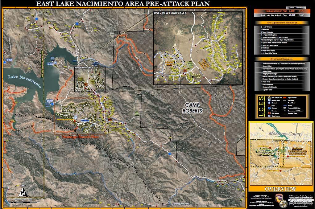
4 CWPP / UNIT FIRE PLAN Individual CAL FIRE Unit Fire Management Plans document assessments of the fire situation within each of CAL FIRE's 21 Units and six contract counties. The plans include stakeholder contributions and priorities, and identify strategic areas for pre-fire planning and fuel treatment as defined by the people who live and work with the local fire problem.


5 The Golden Hour of Emergency Response Planning and preparedness are crucial precursors to an actual wildfire response: The phrase golden hour is often used in wildfire situations to describe the opportunities for saving lives. First responders must get to the scene, size up the emergency, and deploy: life-saving opportunities exist primarily in the first hour of an emergency and decline rapidly thereafter.


6 INCIDENT PLANNING In wildfire response situations, the golden hour becomes critical as the tasks from planning and mitigation are applied in real-time. Incident commanders and wildfire managers must be able to quickly answer tons of questions.


7 BEFORE GIS The majority of pre-attack plans exist for large facilities, buildings, and commercial areas. These plans, typically gathered in mapbooks and provide intelligence on floor layouts, construction details, important hazards, safety information, response requirements, tactical recommendations, etc. that may be vital to establish a safe firefighting strategy
8 PRE-PLANNING WITH GIS In the last decade, geographic techniques have increased and been broadly applied to the fire service. Geographic information systems (GIS) have become a major tool for the fire service to improve preparedness, response and recovery to incidents. Quality spatial information is critical to effectively managing a dynamic incident where large numbers of public safety resources are deployed with various assignments. GIS techniques have made access to maps and imagery commonplace. However, the maps generally lack important details, particularly in WUI areas where wildland fires occur.

9
10
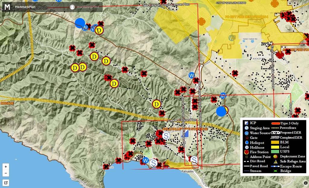
11 WHAT IS INCLUDED IN THE PLAN? Content Operation and Safety Briefing Information Mission / Command Organization Structure Defense Strategies Specific to planning area Construction Type Zoning type Communications Cell / Radio Quality of reception (identify poor coverage areas) Service / Support Air attack (Air to Ground frequencies) Logistical information
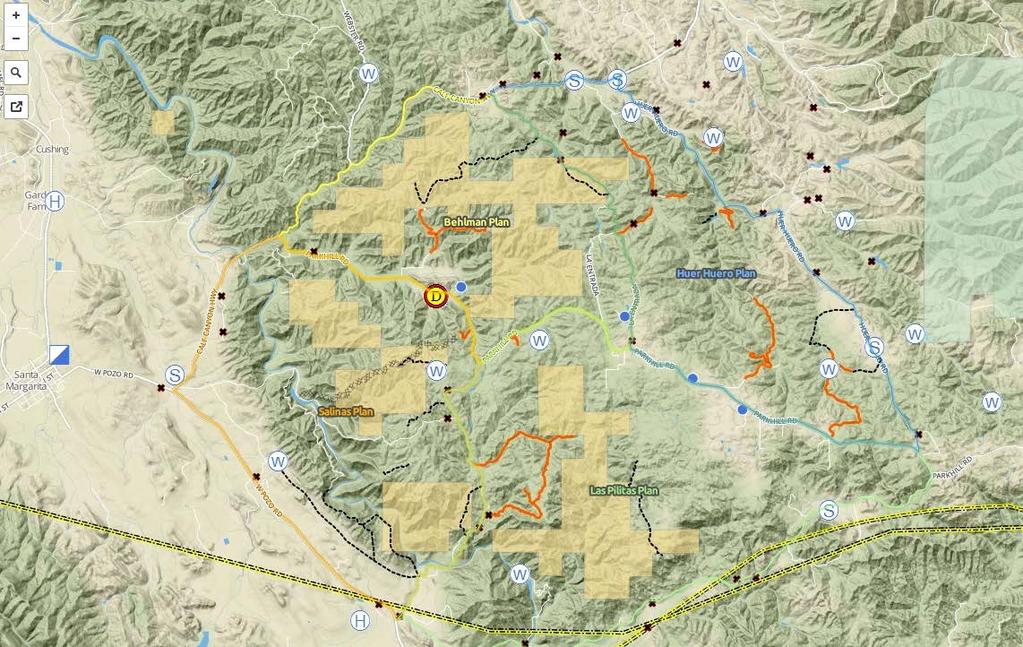
12 WHAT IS INCLUDED IN THE PLAN? Risk Management considerations Power lines / Pipelines / Known Local Hazards (asbestos) General Safety When to get out Ingress / Egress route safety Identify trigger points General Plan description Acres Fire History Objectives Life / Property General Command Considerations Land Ownership Incident Facilities / Incident Command Posts / Staging areas / Safe Refuse Areas / Safety Zones / Drop Points / Lookout sites
13 WHAT IS INCLUDED IN THE PLAN? Specific Command Considerations Demographics ( income level / single or multi family residential / primary or vacation homes) Structures (Address) Access (Gates / Bridges / Dirt Roads passable impassable / Engine type 1 or 3) Fuels Energy Release Component (pocket card) Typical Live to Dead Fuel Ratio Typical seasonal Fuel Moisture Expected Fire Behavior Topography Weather (Trends Daily and Seasonal) Water Sources Road Network

14 WHAT IS INCLUDED IN THE PLAN? Evacuation Considerations / Road Closures Ingress / egress routing Control Points Evacuation Shelters Animal Evacuation Needs Public Information Officer Assignments Cooperating Agencies Recourse Request Recommendations Pre-positioning needs
15
16

17 OFFLINE APPLICATION Android, ios app
18 OTHER ALL RISK PLANS Other predictable natural disasters such as earthquakes, floods, and tsunamis use GISbased pre-incident maps also to aid with planning, response, and recovery. Tsunami Pre-Attack Plans Evacuation Plans Public Audience Tsunami Wildland Active Shooter Public Facilities Schools
19
20
21
22
23 WEB BASED FUTURE Currently, CALFIRE, is testing a Web-based, Next-generation Incident Command System (NICS) that utilizes real-time maps to display spatial information such as engine and firefighter locations, evacuation routes, wildfire lines, fuel breaks, and weather conditions. Similarly, the USFS is evaluating new technology and developing spatial information delivery on a mobile platform to support wildfire operations with the Interra Product.
24 NICS

25 OPEN STREET MAP

26
27


28 FUNDING Sources FireSafe Council County OES Cal Poly San Luis Obispo County Fire Department Production Costs $ $7000 GIS Labor Hours $ $4000 Print Layout $ $4000 Printing 1000 plans
29 QUESTIONS? Links FireAdaptiveCommunities.org Calfireslo.org PDF Maps OpenStreetMap.com MapBox.com
ArcGIS for Emergency Management An Overview. Walter Potts Nikki Golding
 ArcGIS for Emergency Management An Overview Walter Potts Nikki Golding Agenda Introduction Solution Offering What s Next? Your Feedback ArcGIS as a Platform Knowledge Workers Executive Access Public Engagement
ArcGIS for Emergency Management-
 ArcGIS for Emergency Management- Configuring the Solutions Jess Neuner Nikki Golding Agenda Introduction Solution Offering What s Next Your Feedback ArcGIS as a Platform Simple, Open, and Configurable
Emergency Management Maps
 ArcGIS for Emergency Management Emergency Management Maps JESS NEUNER ArcGIS for Emergency Management A solution to support the EM Mission Series of useful maps and apps focused on emergency management
Executive Summary. San Marcos Pass - Eastern Goleta Valley Mountainous Communities Community Wildfire Protection Plan
 Executive Summary San Marcos Pass - Eastern Goleta Valley Mountainous Communities Community Wildfire Protection Plan The San Marcos Pass and Eastern Goleta Valley (SMP/EGV) Mountainous Communities Community
Situational Awareness Overview
 ArcGIS for Emergency Management Situational Awareness Overview JESS NEUNER ArcGIS for Emergency Management A solution to support the EM Mission Series of useful maps and apps focused on emergency management
ArcGIS for Emergency Management Configuring the Situational Awareness Solutions. Jess Neuner
 ArcGIS for Emergency Management Configuring the Situational Awareness Solutions Jess Neuner ArcGIS for Emergency Management A solution to support the EM Mission Series of useful maps and apps focused on
ESF #1Transportation Roles and Responsibilities
 ESF #1Transportation Roles and Responsibilities Purpose: Coordinate all emergency transportation resources for the response to and recovery from any disaster in Woodbury County. Organization Primary Agency:
ArcGIS for Emergency Management. Jess Neuner Nikki Golding
 ArcGIS for Emergency Management Jess Neuner Nikki Golding Agenda Introduction Solution Offering What s Next Your Feedback ArcGIS as a Platform Simple, Open, and Configurable Knowledge Workers Executive
Santa Clara Valley Water District
 Santa Clara Valley Water District Emergency Operations Center EOC Operations Briefing January 12, 2000 Bob Fields, CEM Emergency Preparedness Coordinator Welcome to the Santa Clara Valley Water District
Drought THIRA Capability Statement Worksheet 1
 Drought THIRA Statement Worksheet 1 Community Resilience Description: Enable the recognition, understanding, communication of, and planning for risk and empower individuals and communities to make informed
NIST Community Resilience Planning Resources
 NIST Community Resilience Planning Resources Worse Case Effects of Hurricanes, Fluvial Flooding, High Tides, and Sea Level Rise on DelDOT Assets Meeting University of Delaware, Lewes, Delaware October
ArcGIS for Emergency Management. Nikki Golding
 ArcGIS for Emergency Management Nikki Golding Agenda Introduction Solution Offering What s Next Your Feedback ArcGIS as a Platform Simple, Open, and Configurable Knowledge Workers Executive Access Public
Community Wildfire Protection Plan Development Process for Santa Barbara County
 Community Wildfire Protection Plan Development Process for Santa Barbara County The purpose of a Community Wildfire Protection Plan (CWPP) is to identify and prioritize areas for hazardous fuel reduction
Public Safety GIS Position Qualifications Version 1.0
 GEOGRAPHIC INFORMATION SYSTEMS (GIS) SUPERVISOR Public Safety GIS Position Qualifications DESCRIPTION The Type 1 GIS Supervisor is responsible for: 1. Providing oversight on GIS activities of multiple
Wildfire Management. An Executive Summary. GXP Platform
 Wildfire Management An Executive Summary GXP Platform BAE Systems, Inc. is the U.S. subsidiary of BAE Systems plc, a global defense, security and aerospace company which delivers a full range of products
Testing Your Operational Readiness with Outside Agencies. Tom Clark, CBCP Director, IT Infrastructure Continuity Services Liberty Mutual Group
 Testing Your Operational Readiness with Outside Agencies Tom Clark, CBCP Director, IT Infrastructure Continuity Services Liberty Mutual Group Operational Readiness Capability of an organization to continually
Large Fire Response. Issues with wildfire: WUI & Fire Adapted Communities, Evacuations & Ready Set Go Prevention Preparedness
 Issues with wildfire: WUI & Fire Adapted Communities, Evacuations & Ready Set Go Prevention Preparedness 2018 Fire Season Outlook Highlights Incident management jurisdictions initial attack vs. extended
ArcGIS for Emergency Management 1:00 2:15pm
 Esri Southwest User Conference September 17-19, 2012 Denver, Colorado ArcGIS for Emergency Management 1:00 2:15pm Jeff Baranyi jbaranyi@esri.com @GISPublicSafety 303-449-7779 Agenda Overview of ArcGIS
Increasing Community Resilience
 Increasing Community Resilience Planning, Mitigation & the Role of GIS Ryan Lanclos Emergency Management Industry Manager Esri Responsible for helping our communities: Mitigate Risk Reduce Impact Recover
NDSU - North Dakota Forest Service North Dakota Cooperative Fire Protection Initiative Budget Request
 Agency Information NDSU - North Dakota Forest Service North Dakota Cooperative Fire Protection Initiative 2015-17 Budget Request North Dakota State Board of Higher Education May 29, 2014 NDSU-North Dakota
Three sets of performance measures are available to you. These are:
 The Performance Scales on the following pages were developed to help improve feedback to Incident Management Teams and Agency Administrators involved in complex, inter-jurisdictional wildfires with the
Community Wildfire Protection Plan. Big Elk Meadows Larimer County, Colorado 7/3/2007
 Community Wildfire Protection Plan Big Elk Meadows Larimer County, Colorado 7/3/2007 Introduction This Community Wildfire Protection Plan (CWPP) was developed by Big Elk Meadows with guidance and support
Land Use Planning to Reduce Wildfire Risk: Lessons from Five Western Cities
 Land Use Planning to Reduce Wildfire Risk: Lessons from Five Western Cities Land Use Planning Strategies to Reduce Wildfire Risk Community Initiatives Voluntary Property Assessment Partnerships and Coalitions
ArcGIS for Emergency Management: An Overview
 2013 Esri International User Conference July 8 12, 2013 San Diego, California Technical Workshop ArcGIS for Emergency Management: An Overview Jeff Baranyi Lindsay Thomas Esri UC2013. Technical Workshop.
Mitigation Plan Mission, Goals and Action Items
 Section 4: Mitigation Plan Mission, Goals and Action Items Introduction... 2 Mission... 2 Mitigation Plan Goals... 2 Natural Hazard Mitigation Plan Action Items... 3 Coordinating Organization... 4 Partner
Unit 2: NRF Overview
 : Unit Introduction Visual 2.1 Visual Description: Unit Introduction Unit 2 provides a general overview of the National Response Framework, or NRF. October 2008 IS-800: National Response Framework Student
TECOLOTE FIRE RESEARCH FINDINGS SUMMARY
 Toddi Steelman, Ph.D. * Branda Nowell, Ph.D * Deena Bayoumi, M.P.A. * Caitlin Burke, Ph.D. Anne-Lise Velez * Jason Briefel, M.S. North Carolina State University Sarah McCaffrey, Ph.D. USFS Northern Research
EMERGENCY MANAGEMENT EMERGENCY SUPPORT FUNCTION (ESF #5) FORMERLLY ASSESSMENT INFORMATION PLANNING
 FORMERLLY ASSESSMENT INFORMATION PLANNING") Assessment, Information and Planning ICS Category: Planning ESF # 5 Responsible for Assessment, Information and Planning Reports to the Planning Coordinator DATE OF ACTIVATION: REASON FOR ACTIVATION: ESF
Assessment, Information and Planning ICS Category: Planning ESF # 5 Responsible for Assessment, Information and Planning Reports to the Planning Coordinator DATE OF ACTIVATION: REASON FOR ACTIVATION: ESF
ANNEX M: HAMILTON CREEK METROPOLITAN DISTRICT
 ANNEX M: HAMILTON CREEK METROPOLITAN DISTRICT M.1 Community Profile (HCMD) is a special district in Summit County. The District operates under the direction of a five person, elected Board of Directors.
Agency Dispatch: The agency or jurisdictional facility from which resources are sent to incidents.
 Glossary Agency: A division of government with a specific function offering a particular kind of assistance. In the Incident Command System, agencies are defined either as jurisdictional (having statutory
Resolution No. 46 COMMITTEE ASSIGNMENT: Health & Safety Re: Wildfire and WUI Research and Education Collaboration
 Resolution No. 46 COMMITTEE ASSIGNMENT: Health & Safety Re: Wildfire and WUI Research and Education Collaboration 1 WHEREAS, the IAFF has always been the 2 leader in improving firefighter safety through
Emerging Threats: The importance of Interagency Coordination WEATHERING THE STORM 6 TH ANNUAL REGIONAL DISASTER CONFERENCE
 Emerging Threats: The importance of Interagency Coordination WEATHERING THE STORM 6 TH ANNUAL REGIONAL DISASTER CONFERENCE WORLDWIDE THREAT ASSESSMENT of the US INTELLIGENCE COMMUNITY February 9, 2016
EMERGENCY OPERATIONS PLANNING AND CONTINUITY OF OPERATIONS
 EMERGENCY OPERATIONS PLANNING AND CONTINUITY OF OPERATIONS County Commissioner Clerks/Engineers Administrative Professional Association Winter Conference - Columbus Convention Center Emergency Management
Wildfire in South Carolina
 Wildfire in South Carolina Average number of wildfires per year 3,000 Average acres per year 20,000 Average acres per fire 6.7 Wildfires happen almost every day across SC! January 29 Fire Activity A Landscape
Fire & Fuels Management
 Overview Fire & Fuels Management Southern California Adaptation Implementation Plan During a two- day workshop in January 2016, southern California resource managers and regional stakeholders discussed
PLANNING FOR A COMMUNITY WILDFIRE PROTECTION PLAN
 PLANNING FOR A COMMUNITY WILDFIRE PROTECTION PLAN San Luis Obispo County Senior Project Prepared by Justin Sauder B.S. City and Regional Planning Cal Poly San Luis Obispo Advisor: William Siembieda Summer
Planning for Growth and Open Space Conservation
 Planning for Growth and Open Space Conservation This webinar series is sponsored by: USDA Forest Service State and Private Forestry - Cooperative Forestry Organized by Rick Pringle, Susan Stein, Sara Comas,
First Revision No. 78-NFPA [ Global Input ] Submitter Information Verification. Committee Statement 6/18/2014 3:30 PM
![First Revision No. 78-NFPA [ Global Input ] Submitter Information Verification. Committee Statement 6/18/2014 3:30 PM](/thumbs/78/76908995.jpg "First Revision No. 78-NFPA [ Global Input ] Submitter Information Verification. Committee Statement 6/18/2014 3:30 PM") of 93 6/18/2014 3:30 PM First Revision No. 78-NFPA 951-2014 [ Global Input ] Change the following instances of "integrated information management system" to "information system": 1.1.3 1.2 1.2.3 1.3.5.1
of 93 6/18/2014 3:30 PM First Revision No. 78-NFPA 951-2014 [ Global Input ] Change the following instances of "integrated information management system" to "information system": 1.1.3 1.2 1.2.3 1.3.5.1
2017 Grants Clearinghouse Competitive Grants Program Report
 2017 Grants Clearinghouse Competitive Grants Program Report August 28, 2017 2017 Highlights 21 PROJECTS AWARDED 15 COUNTIES 27,558 ACRES GRANT AWARDS PROVIDED: $2,100,000 California Fire Safe Council (CFSC)
School Risk Management Planning - Initiative
 Education Facilities Safer Risk Management Viewer Risk Risk ning - Initiative Supporting s and Emergency Response March 5, 2014 Risk Management Project Components The Risk Management Initiative has three
Unit 4: Aviation Fire Operations
 Unit 4: Aviation Fire Operations Unit Reference Number: K/505/5934 Introduction This unit focuses on the strategies and activities required to evaluate and resolve fire and rescue incidents in aviation
IFE Level 4 Certificate in Fire Science and Fire Safety
 IFE Level 4 Certificate in Fire Science and Fire Safety Unit 4: Aviation Fire Operations Unit Reference Number: K/505/5934 Introduction This unit focuses on the strategies and activities required to assess
ArcGIS for Emergency Management. Walter Potts Jeff Baranyi Nikki Golding
 ArcGIS for Emergency Management Walter Potts Jeff Baranyi Nikki Golding Agenda Introduction Solution Offering What s Next? Your Feedback A common experience. Hurricane Sandy 2004 2005 Southeast Tornadoes
PHILADELPHIA OFFICE OF EMERGENCY MANAGEMENT SUPPORTING REAL-TIME EMERGENCY MANAGEMENT WITH THE ARCGIS PLATFORM
 PHILADELPHIA OFFICE OF EMERGENCY MANAGEMENT SUPPORTING REAL-TIME EMERGENCY MANAGEMENT WITH THE ARCGIS PLATFORM Brian Wells Philadelphia OEM Andrew Smart geographit GIS in Emergency Management - Key Considerations
ANNEX FIRE RESOURCE MANAGEMENT
 ANNEX FIRE RESOURCE MANAGEMENT I. PURPOSE The purpose of this annex is to establish a process for comprehensive fire resource management within Washington County during large-scale emergencies, along with
GIS Deployment at DeepWater Horizon. Lessons Learned 2010
 GIS Deployment at DeepWater Horizon Lessons Learned 2010 Primary Workflows Supported by GIS Connecting Individuals, Organizations and Communities Modeling and Analysis Planning Operations Field Data Collection/Damage
Emergency Support Function (ESF) 5 Information and Planning (Planning Section)
 5 Information and Planning (Planning Section)") Emergency Support Function (ESF) 5 Information and Planning (Planning Section) Lead Coordinating Agency: Escambia County, Development Services Bureau Support Agencies: Escambia County Emergency Management
Emergency Support Function (ESF) 5 Information and Planning (Planning Section) Lead Coordinating Agency: Escambia County, Development Services Bureau Support Agencies: Escambia County Emergency Management
Unit 3: NIMS Preparedness
 Unit 3: NIMS Preparedness This page intentionally left blank. Objectives At the end of this unit, you should be able to: Describe the importance of preparedness. Identify the NIMS mechanisms and tools
Emergency Ready Profile: A Fit For Any Contingency Plan. Disaster Recovery Team
 Emergency Ready Profile: A Fit For Any Contingency Plan If an emergency strikes, will you be ready? Getting to Know SERVPRO SERVPRO s independently owned and operated Franchises have been helping business
Humboldt County Community Wildfire Protection Plan 2013 UPDATE
 Humboldt County Community Wildfire Protection Plan 2013 UPDATE Humboldt County Fire Safe Council A committee appointed by your Board to oversee the maintenance and implementation of the County s fire plan
NATIONAL TRAINING CURRICULUM
 INCIDENT COMMAND SYSTEM Canadian version CANADIAN NATIONAL TRAINING CURRICULUM ICS ORIENTATION Module 1 I-100 REFERENCE TEXT OCTOBER 2002 INCIDENT COMMAND SYSTEM Canadian Version CANADIAN TRAINING CURRICULUM
SEMS Emergency Operations Center (EOC) Course for Schools. Orange County Emergency Management Organization Schools Committee
 Course for Schools. Orange County Emergency Management Organization Schools Committee") SEMS Emergency Operations Center (EOC) Course for Schools Orange County Emergency Management Organization Schools Committee Nine SEMS EOC Course Modules SEMS Overview [C1] Disaster Management Principles
SEMS Emergency Operations Center (EOC) Course for Schools Orange County Emergency Management Organization Schools Committee Nine SEMS EOC Course Modules SEMS Overview [C1] Disaster Management Principles
Standardized Emergency Management (SEMS) Executive Course (ICS 402)
 Executive Course (ICS 402)") Standardized Emergency Management (SEMS) (ICS 402) Version 8-17 Duration 120 Minutes Standardized Emergency Management System (SEMS) Scope Statement This course provides participants with an overview,
Standardized Emergency Management (SEMS) (ICS 402) Version 8-17 Duration 120 Minutes Standardized Emergency Management System (SEMS) Scope Statement This course provides participants with an overview,
Hamlet of Tulita. Community Wildfire Protection Plan
 Hamlet of Tulita Community Wildfire Protection Plan Prepared for: Government of the Northwest Territories Environment and Natural Resources - Forest Management Division March 2011 Stew Walkinshaw, R.P.F.
UNIT 4: INCIDENT RESOURCE MANAGEMENT
 INCIDENT RESOURCE MANAGEMENT PURPOSE AND SCOPE The purpose of this unit is to acquaint you with the resource categories that you may encounter at an incident. This unit will introduce the concept of incident
GREEN SHEET. California Department of Forestry and Fire Protection
 GREEN SHEET California Department of Forestry and Fire Protection Investigation Summaries of Serious CDF Injuries, Illnesses, Accidents and Near-Miss Incidents Wildland Fire Entrapment Minor Burn Injuries
Essential Concepts. For Effective. Business Continuity Planning
 Essential Concepts For Effective Business Continuity Planning 1 What is a Business Continuity Plan (BCP)? A Business Continuity Plan (BCP) is a comprehensive set of business strategies and actions designed
Unit 6: Organizational Flexibility. Visual 6.1 Organizational Flexibility
 Unit 6: Organizational Flexibility Visual 6.1 Unit Objectives Explain how the modular organization expands and contracts. Complete a complexity analysis when given a scenario. Define the five types of
California Emergency Operations Center (CalEOC) Category: Data, Information and Knowledge Management
 Category: Data, Information and Knowledge Management") NASCIO 2014 STATE IT RECOGNITION AWARDS California Emergency Operations Center (CalEOC) Category: Data, Information and Knowledge Management Project Initiation Date: April 2012 Project Completion Date:
NASCIO 2014 STATE IT RECOGNITION AWARDS California Emergency Operations Center (CalEOC) Category: Data, Information and Knowledge Management Project Initiation Date: April 2012 Project Completion Date:
SITUATIONAL AWARENESS ANY TIME ANY PLACE
 SITUATIONAL AWARENESS ANY TIME ANY PLACE GLOBAL EMERGENCY RESOURCES - WHEN MINUTES COUNT AND LIVES ARE ON THE LINE, YOU NEED THE RIGHT SOLUTIONS. LOCAL COMMUNITIES, GOVERNMENT AGENCIES, AND INDEPENDENT
MODULE 1 ICS ORIENTATION
 STANDARDIZED EMERGENCY MANAGEMENT SYSTEM APPROVED COURSE OF INSTRUCTION FIELD COURSE MODULE 1 ICS ORIENTATION AUGUST 1995 STUDENT REFERENCE MANUAL CONTENTS CONTENTS... i STUDENT INFORMATION... 1 Course
Activities of Research Initiative for Natural Disaster Prevention of Oil and Gas Spill in Industrial Parks
 NATECH 2016 Jan 12-13, 2016 Activities of Research Initiative for Natural Disaster Prevention of Oil and Gas Spill in Industrial Parks Naomi Kato Osaka University Background Large oil spill from oil tanks
Triage and Pre-Hospital Treatment Exercise Evaluation Guide
 Exercise Evaluation Guide Submittal Triage and Pre-Hospital Treatment Exercise Evaluation Guide As the evaluator you will need to submit your Observations, Recommendations and Performance Ratings into
DOWNLOAD OR READ : WILDFIRES AND WILDFIRE MANAGEMENT PDF EBOOK EPUB MOBI
 DOWNLOAD OR READ : WILDFIRES AND WILDFIRE MANAGEMENT PDF EBOOK EPUB MOBI Page 1 Page 2 wildfires and wildfire management wildfires and wildfire management pdf wildfires and wildfire management A wildfire
Volcanoville Community Wildfire Protection Plan
 Volcanoville Community Wildfire Protection Plan Review and Update of the Volcanoville Community Fire Safe and Fuels Reduction Plan, June 00 September 01 Volcanoville CWPP 01 Final Page 1 1 1 1 1 1 1 1
Preparing a Community Wildfire Protection Plan
 Preparing a Community Wildfire Protection Plan A Handbook for Wildland Urban Interface Communities Sponsored By: Communities Committee National Association of Counties National Association of State Foresters
9.0 KINGS CANYON LOWER
 9.0 KINGS CANYON LOWER FUEL HAZARD: MODERATE COMMUNITY RISK: LOW The Lower Kings Canyon neighborhood contains the Kings Canyon Highlands and Kings Canyon Meadows subdivisions to the west of Longview Way:
Mississippi Emergency Support Function #12 Energy Annex
 Mississippi Emergency Support Function #12 Energy Annex ESF #12 Coordinator Mississippi Public Utilities Staff Primary Agencies Mississippi Public Utilities Staff Support Agencies Mississippi Emergency
Truckee Fire Protection District Community Wildfire Protection Plan Final
 Truckee Fire Protection District Community Wildfire Protection Plan Final Prepared by: Wildland Rx and Deer Creek Resources 11-8-2016 Contents Truckee Fire Protection District Community Wildfire Protection
SAFETY AND NOISE 9. Safety and Noise
 SAFETY AND NOISE 9 9 Safety and Noise Safety is a basic human need and is required for a community to thrive. The goals and policies in this element are designed to protect and enhance public health and
Insert a short description of any ongoing response and assessments already conducted:
 DNA 2 Terms of Reference Template for Completion Note on the ToR: This document has been prepared to guide agencies responsible for a Disaster Needs Assessment (DNA) in preparing a ToR for the assessment.
Noise and Safety P a g e
 11 Noise and Safety 11-1 P a g e Chapter 11 Noise and Safety Element The main goal of this chapter is to combine the Goals and Policies of the Noise and Safety Elements of the 2003 General Plan into one
NIMS IS 700b Outline
 NIMS IS 700b Outline NIMS Guiding Principles NIMS provides these stakeholders across the whole community with the shared vocabulary, systems, and processes to successfully deliver the capabilities described
Produced by Cuyahoga County Office of Emergency Management
 Produced by Cuyahoga County Office of Emergency Management Mission Statement: The Cuyahoga County Office of Emergency Management is responsible for activities relating to emergency planning, preparedness,
EMERGENCY SIGNAL KIT
 EMERGENCY SIGNAL KIT EMERGENCY INCIDENT PRIORITIES Life Safety - Incident Stabilization - Property Conservation (LIP) Emergency Signals are placed on homes and buildings after an emergency so neighbors
Appendix C Risk Assessment Methods
 Appendix C Risk Assessment Methods The following section outlines the specific methods, data, and values used to evaluate wildfire risk in Lane County. Identifying the Wildland Urban Interface Risk The
Environmental Analysis Tools An Overview. Jess Neuner begins at 10:30
 Environmental Analysis Tools An Overview Jess Neuner begins at 10:30 ArcGIS for State Government Esri solutions for local government customers Series of useful maps and apps focused on state government
Don t Panic! How to develop and implement an emergency response plan for your attraction
 Don t Panic! How to develop and implement an emergency response plan for your attraction Paul Chatelot, Director / Prevention, Safety & Environment DiSNEYLAND PARIS September 19, 2016 Agenda Don t panic
Enhancing Efficiency in Poudre Fire Authority s Wildland Urban Interface Operations
 National Fire Grant 03-7350-063 Final Close-Out Report Enhancing Efficiency in Poudre Fire Authority s Wildland Urban Interface Operations Submitted by Geoff Butler and Kelly Close Poudre Fire Authority
CAL VIVA: ASSESSING THE SEISMIC VULNERABILITY OF CALIFORNIA S STATE-OWNED BUILDINGS THROUGH PLANNING & ENGINEERING
 10NCEE Tenth U.S. National Conference on Earthquake Engineering Frontiers of Earthquake Engineering July 21-25, 2014 Anchorage, Alaska CAL VIVA: ASSESSING THE SEISMIC VULNERABILITY OF CALIFORNIA S STATE-OWNED
Supporting Employees During Times of Extreme Circumstance
 Supporting Employees During Times of Extreme Circumstance Fiona Raymond-Cox President, Business Recovery Managers Association Presentation Overview Response Measures California Wildfire Case Study Page
SFJFRSFF6 SQA Unit Code (H9FE 04) Maintain readiness for fire and rescue operational response
 Maintain readiness for fire and rescue operational response") Overview This standard is recommended for firefighters. This standard is about your ability to maintain your organisation s readiness for operational response to fires and other incidents, either as an
Overview This standard is recommended for firefighters. This standard is about your ability to maintain your organisation s readiness for operational response to fires and other incidents, either as an
Time of Alarm: 1755, Sunday, 10/21/2007 Fire Contained: 1800, Thursday, 11/8/2007 Acres Burned: 28,400 Acres
 Santiago Fire October 21, 2007 Santiago Fire Time of Alarm: 1755, Sunday, 10/21/2007 Fire Contained: 1800, Thursday, 11/8/2007 Acres Burned: 28,400 Acres Homes Evacuated: 1,900 Homes Weather Conditions:
2015 ASFPM Conference Atlanta, Georgia
 2015 ASFPM Conference Atlanta, Georgia No Adverse Impact Floodplain Mgmt., Natural & Beneficial Functions of Floodplains, and the Cost of Community Services: Not All Lands are Suitable for All Purposes
SUCCESSFUL CRISIS MANAGEMENT FOR YOUR ORGANIZATION. by Regina Phelps, Founder, EMSS Solutions
 SUCCESSFUL CRISIS MANAGEMENT FOR YOUR ORGANIZATION by Regina Phelps, Founder, EMSS Solutions Introduction How does your organization manage an incident affecting the whole company? Who is in charge? What
1 ST Responders Guide to Clandestine Laboratories
 OVERVIEW are locations that utilize chemicals, supplies, and laboratory equipment for the specific production of illicit drugs, and will include at times, the use of chemicals to produce improvised explosives.
Mass Notification System
 Mass Notification System 2 2,500+ Local Governments 55,000+ Users Emergency and Routine Communications Made Easy 60+ Million People Impacted CivicPlus was founded over 20 years ago to help local governments
Wildfire Risk Assessment Taos County October 4, Kimiko Barrett, PhD Headwaters Economics
 Wildfire Risk Assessment Taos County October 4, 2016 Kimiko Barrett, PhD Headwaters Economics Presentation Overview Who We Are What We Did Wildfire Risk Modeling Identify Fuels Treatment Project Locations
UNIT 3. EOC ORGANIZATIONAL STRUCTURES AND STAFFING
 UNIT 3. EOC ORGANIZATIONAL STRUCTURES AND STAFFING This page intentionally left blank. INTRODUCTION AND OBJECTIVES Visual 3.1 Unit 3 will cover a myriad of EOC organizational structures and the challenges
ArcGIS for Environment and Natural Resources An Overview. Matt Bullock Nikki Golding
 ArcGIS for Environment and Natural Resources An Overview Matt Bullock Nikki Golding Agenda Introduction Solution Offering What s Next? Your Feedback ArcGIS as a Platform Knowledge Workers Executive Access
SITUATION REPORT (SITREP) #001 INITIAL 10/28/ HRS HUNTERDON COUNTY DIVISION OF EMERGENCY MANAGEMENT HURRICANE SANDY
 #001 INITIAL 10/28/ HRS HUNTERDON COUNTY DIVISION OF EMERGENCY MANAGEMENT HURRICANE SANDY") SITUATION & SUMMARY OF EVENTS The Hunterdon County Division of Emergency Management continues to monitor the progress of Hurricane Sandy, in coordination with the New Jersey Office of Emergency Management
SITUATION & SUMMARY OF EVENTS The Hunterdon County Division of Emergency Management continues to monitor the progress of Hurricane Sandy, in coordination with the New Jersey Office of Emergency Management
Quick Reference Guide To Emergency Commercial Livestock Relocation
 Quick Reference Guide To Emergency Commercial Livestock Relocation Section 1: Overview With agriculture operations throughout British Columbia, it is inevitable that emergencies and disasters impact farm
Mitigation Measures for Natural Hazards
 Mitigation Measures for Natural Hazards Mitigation measures are actions that eliminate or reduce risks from future disaster events, including: Physical construction projects such as replacing a highly
Fire Adapted Communities on the Plains. Master Volunteer Forest Steward Course Lisa Mason, Colorado State Forest Service April 22, 2014
 Fire Adapted Communities on the Plains Master Volunteer Forest Steward Course Lisa Mason, Colorado State Forest Service April 22, 2014 About the CSFS The mission of the CSFS is to achieve stewardship of
IBM Smarter Cities Public Safety Emergency Management
 IBM Industry Solutions Government IBM Smarter Cities Public Safety Emergency Management 2 IBM Smarter Cities Public Safety Emergency Management The first obligation of a city is to protect its citizens
University of Kentucky Hazard Mitigation Plan Update
 University of Kentucky Hazard Mitigation Plan Update Kick-off Steering Committee Meeting November 7, 2014 Chief Joe Monroe UK Police Department Captain Tom Matlock UK Crisis Management and Preparedness
CONTINUITY OF OPERATIONS PLAN
 CONTINUITY OF OPERATIONS PLAN (TEMPLATE) NAME OF ORGANIZATION/BUSINESS ADDRESS PHONE NUMBER Organization Logo Continuity of Operations Plan Version 1.5 Table of Contents I. Introduction... 1 II. Purpose...
PREPARING FOR EFFICIENT RESPONSE AND RAPID RECOVERY
 SAP Solution in Detail SAP for Public Sector Emergency Management HELP from SAP and Business Objects PREPARING FOR EFFICIENT RESPONSE AND RAPID RECOVERY The SAP Emergency Management for Public Sector package
FRENCH GULCH (UPPER CLEAR CREEK) PLANNING AREA
 PLANNING AREA") 2016 SHASTA COUNTY COMMUNITY WILDFIRE PROTECTION PLAN FRENCH GULCH (UPPER CLEAR CREEK) PLANNING AREA Covering the community of: French Gulch FRENCH GULCH (UPPER CLEAR CREEK) PLANNING AREA (2016) I. PROPOSED
2016 SHASTA COUNTY COMMUNITY WILDFIRE PROTECTION PLAN FRENCH GULCH (UPPER CLEAR CREEK) PLANNING AREA Covering the community of: French Gulch FRENCH GULCH (UPPER CLEAR CREEK) PLANNING AREA (2016) I. PROPOSED
Disaster Preparedness, Response, and Post-Disaster Operations. Shawn D. Smith -- Emergency Visions, Inc.
 Disaster Preparedness, Response, and Post-Disaster Operations Shawn D. Smith -- Emergency Visions, Inc. About Emergency Visions E X P E R T I S E B A N D W I D T H T O O L S Emergency Visions provides