FAIRFAX COUNTY PARK-AND-RIDE DEMAND ESTIMATION STUDY
|
|
|
- Ruth Whitehead
- 6 years ago
- Views:
Transcription


1 FAIRFAX COUNTY PARK-AND-RIDE DEMAND ESTIMATION STUDY Michael Demmon GIS Spatial Analyst Fairfax County, DOT Fairfax, VA Scudder Wagg Planner Michael Baker Jr, Inc. Richmond, VA Additional support from: Caijun Luo, Transportation Planner, Fairfax County DOT Virginia Dept. of Transportation, Multi-Modal Planning Office Peggy Malone and Associates March 28, 2011 GIS-T Symposium GIS Analysis using Network Analyst
2 Outline Introduction Study Area Current Park & Ride Development techniques Goals of a Park & Ride Problem Definition Data Collection Application Design First Response Challenges of modeling real-world scenarios Examples Future Considerations & Conclusions

 395 Square Miles in area 1.")
3 Study Area Fairfax County & the Washington D.C. Area Washington D.C. MSA Fairfax County, Virginia 22 Jurisdictions included covering 3 states (6 cities, 15 counties, 1 district) 395 Square Miles in area 1.1 Million residents 8.2 Million residents Worst congestion in the nation* 70+ Hours wasted due to commute delays* 2 nd highest Median Household Income in the Nation Most populous jurisdiction in Virginia and the Washington Metro area 7 Transit organizations operating in, or passing through Fairfax County *(The 2010 Urban Mobility Study By TTI)
4 Existing Methodology Planners observe existing conditions, review development plans and make educated guesses of Park & Ride demand Currently, Site typically drives specifics Area/location Size Ease of Access (commuter, pedestrian, bike, etc) General understanding that transit service options greatly effect usage of Park & Ride facility Optimal utilization ranges between 70-85% capacity
 corridor 6 Lots along other highvolume corridors 28,394 Total")
5 Park & Ride Facilities in Fairfax County 39 Park & Ride lots 7 Lots at Metro rail stations 4 along I-66, 3 along I-95 & I Lots at Virginia Rail Express (VRE) stations 9 Lots along I-95 corridor 10 Lots along I-66 corridor 4 Lots along VA 267 (Dulles Toll Rd) corridor 6 Lots along other highvolume corridors 28,394 Total Capacity
6 Commuter Intercept Approaches & Goals Intercept Fairfax county Residents Goal: Eliminate vehicle all together Requirements: provide transit services from origin to destination Strategically place P&R facilities near high-density residential Intercept Non-Fairfax County Residents Goal: Reduce through traffic & overall congestion Requirements: Place large P&R facilities along major corridors Provide express transit service to Metrorail terminal stations

7 Study Areas by Primary Transit Corridor Fairfax County is the largest commuter-origin jurisdiction in the DC area Commuter Corridors Major I-66 from West I-95 from South VA-267 from Northwest* Minor US 1 from South VA 7 from Northwest* US 50 from West* VA 7100 cross county *These routes connect to major arterials & interstates and act as primary collectors.
8 Purpose of Analysis & Development Identify Existing Trends Develop a Park and Ride Demand Analysis application to estimate usage at potential, future Park & Ride locations throughout Fairfax County Provide calculated predictions of usage Automate the process of, and increase the accuracy of determining potential usage of Park & Ride facilities Considerations Available transit services Proximity to regional arterial highways

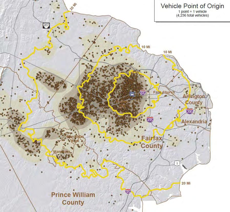
9 Fairfax Park-and-Ride Facilities and Markets
10 Data Collected and Geocoding Summary of Data Collected Park-and-Ride Facilities Counted 36 Vehicles Counted 22,954 Vehicle Plate Numbers Collected 20,435 Addresses Returned from DMV 19,887 Addresses within Virginia 19,344 Successfully Geocoded Addresses 18,296 89% of all vehicles had VA plates. 79.7% of all counted vehicles successfully geocoded.


11 Individual Lot Analysis

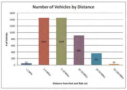
12 Market Area Analysis: Orange Line Median Distance (mi) Park and Ride Lot Spaces Vehicles Straight line Driving East Falls Church West Falls Church 2,025 1, Dunn Loring 1,319 1, Vienna 5,849 5,

13 Market Area Analysis: Southern Fairfax Metro Median Distance (mi) Park and Ride Lot Spaces Vehicles Straight line Driving Van Dorn Street Franconia- Springfield 5,069 4, Huntington 3,090 2,
14 Market Analysis Results Lots differentiated by service and location. MetroRail Service VRE Service Express Bus within 2 miles of freeway Express Bus beyond 2 miles of freeway Local Bus within 2 miles of freeway Local Bus beyond 2 miles of freeway No Transit Service (Car or Vanpool Only) Coefficients for population, households and work trips developed for each lot type.

15 Park-and-Ride Demand Estimation Toolbar Step-by-step process 1. Add, Edit, Delete, Move PnR Locations 2. Change PnR Attributes 3. Create Market Buffers 4. Edit Buffers 5. Calculate Demand Estimates
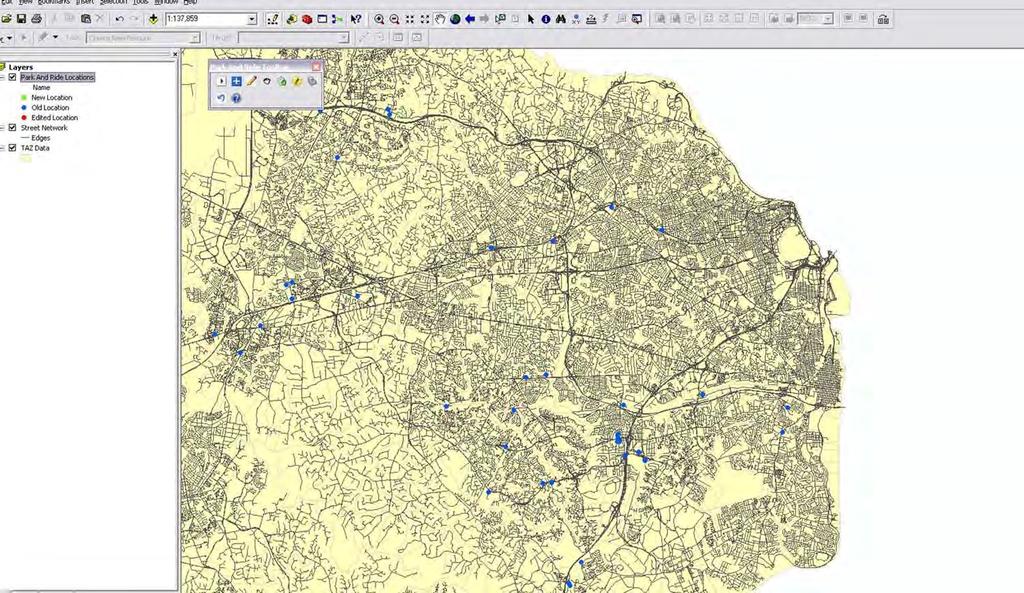
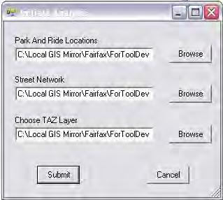
16 Initiating Analysis


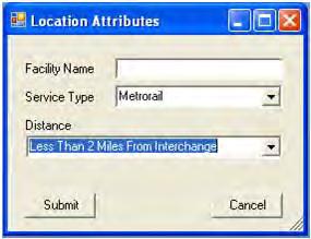
17 Adding, Editing, Deleting PnR Facilities


18 Creating and Editing Market Areas
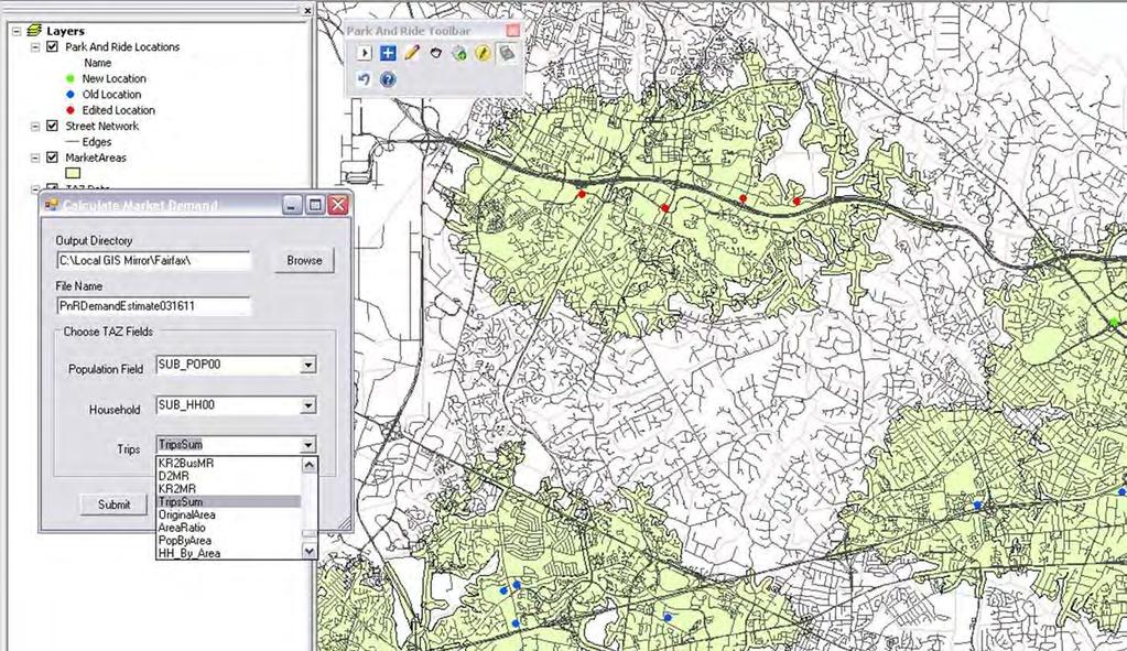
19 Calculating Demand
20 Calculation Process Developed using Model Builder Adjusts for overlapping market areas through spatial join and join count.

21 Calculation in Progress
22 Example Tabular Output Name Estimated Demand Population within Market Area Households within Market Area AM Work Trips within Market Area Population Basis for Demand Estimate Household Basis for Demand Estimate Trip Basis for Demand Estimate Metro ,204 15,211 31,070 8,730 3,374 7,022 Target ,580 15,403 34,221 8,971 3,261 7,597 Chantilly 62 21,019 6,972 14,096 4,409 1,464 2,876 Tysons Corner 1,083 24,019 9,863 21,138 3,931 1,609 3,413
23 New Park & Ride Lots Old Keene Mill P&R Opened November, 2011 Baron Cameron Park P&R Opened January, 2011 Sunset Hills P&R Opens 4/4/2011 Temporary lot during Reston East Metrorail construction Reston East Metrorail Existing lot Closes 4/3 Scheduled to re-open Fall of 2013 Estimated parking capacity of 2300

24 Old Keene Mill Close-up Old Keene Mill P&R 4 PnRs adjacent to each other SLUG line effect Estimated Demand of 334 OKM actual observed usage in first 120 days Averaged 249 Drop at AmL. from avg to avg. of 30 Drop at SUMC from avg. 52 to avg. of 34 Average Usage of 3 south lots is 72% Explanation for difference Proximity of other lots Realignment of commuter parking habits
 Baron Cameron Park P&R Opened January, 2011 Created as overflow for closing of Reston East 50 spaces (no observed usage yet) Estimated Demand of 11 (with RE removed)")
25 Reston East Closure Rest East closing 4/3/ spaces Served by 10 routes Sunset Hills P&R Opens 4/4/ spaces Serviced by 2 routes Estimated Demand of 404 (with RE removed) Baron Cameron Park P&R Opened January, 2011 Created as overflow for closing of Reston East 50 spaces (no observed usage yet) Estimated Demand of 11 (with RE removed)

26 Future Tool Improvements Develop more service options within tool Collect, analyze, and predict more quantitative data relevant to Park & Ride usage More consideration for direction of flow for commuter traffic Incorporate forecast demographics for an understanding of future usage


27 Large-scale regional Park & Ride studies needed Develop more thorough quantitative methods for analyzing regional data Maximize transit options for maximum utilization of Park & Ride facilities CONCLUSIONS
Northern Virginia Region Draft Needs Summary
 Needs Map: Need A A DEMAND The ability of communities around transit stations (particularly the areas within 1-2 miles of the stations and other travel hubs) to attract skilled workers and grow businesses
NEED ECONOMIC TRANSPORTATION LOCATIONS EXAMPLE
 A. Enhance multimodal networks and facilities around transit access points such as existing and emerging rail stations, high capacity bus stops, and intermodal transfer centers There is a need for improved
Fairfax County Countywide Transit Network Study
 Fairfax County Countywide Transit Network Study Proposed High Quality Transit Network Concept Metropolitan Washington Council of Governments Travel Forecasting Subcommittee September 20, 2013 1 Presentation
WELCOME. Schedule. Contact Information. Please Provide Written Comments
 WELCOME Schedule April 18, 2012 Open House: 6:30 p.m. to 8:30 p.m. Project Presentation: 7:00 p.m. Mary Ellen Henderson Middle School 7130 Leesburg Pike Falls Church, VA 2203 Contact Information Kala Leggett
Regional Bus Rapid Transit
 Regional Bus Rapid Transit Efforts Board Transportation Committee October 20, 2009 There are a Variety of Regional Bus Rapid Transit Study Efforts They include: NVTA s TransAction 2030 Plan Transportation
ATTACHMENT A. Detailed Study Scope. I-66 (Inside) Multi-modal Study Scope
 Multi-modal Study Scope") ATTACHMENT A Detailed Study Scope I-66 (Inside) Multi-modal Study Scope EXECUTIVE SUMMARY The Virginia Department of Transportation (VDOT) seeks consultant assistance in identifying and evaluating a range
ATTACHMENT A Detailed Study Scope I-66 (Inside) Multi-modal Study Scope EXECUTIVE SUMMARY The Virginia Department of Transportation (VDOT) seeks consultant assistance in identifying and evaluating a range
Regional Performance Measures Annual Progress Report TPO Board - 2/4/2016 Presentation by: Chris Wichman, Senior Planner
 2015 TPO Board - 2/4/2016 Presentation by: Chris Wichman, Senior Planner Overview History and definition of performance-based planning & programming Review of 2015 TPO Board Action Requested 2 History
Long Range Transportation Plan Project Status Update
 HEPMPO Webinar Meeting Long Range Transportation Plan Project Status Update Michael Baker Jr., Inc. Foursquare Integrated Transportation Planning December 4, 2013 1 Meeting Agenda 1. Project Overview 2.
This document has been developed to provide context to the Board as part of the strategic planning process. Regional development and travel trends
 1 This document has been developed to provide context to the Board as part of the strategic planning process. Regional development and travel trends and forecasts are provided, including population, employment,
NORTHERN VIRGINIA TRANSPORTATION PLAN
 NORTHERN VIRGINIA TRANSPORTATION PLAN November 2012 Table of Contents TransAction 2040 Plan Area...1 Communities and Facilities Covered in TransAction 2040... 1 TransAction 2040 Plan Methodology...2 Individual
Cost-Benefit Analysis of Transit Projects: Current Practice and Methodological Advances
 Cost-Benefit Analysis of Transit Projects: Current Practice and Methodological Advances Elena Safirova Presented at New York University October 26, 2011 Outline What is Cost-Benefit Analysis? Benefits
Contents i Contents Page 1 A New Transportation Plan Community Involvement Goals and Objectives... 11
 Contents i Contents 1 A New Transportation Plan... 1 Why develop a new plan?... 1 What area does the LRTP focus on?... 2 Why is this LRTP important?... 3 Meeting Requirements for Transportation Planning...
EVALUATION OF ALTERNATIVES CARRIED FORWARD
 1 EVALUATION OF ALTERNATIVES CARRIED FORWARD This chapter presents a comparative evaluation of the alternatives carried forward in this Final Environmental Impact Statement (EIS). The intent of this evaluation
US 75 Integrated Corridor Management
 US 75 Integrated Corridor Management Koorosh Olyai,, P.E. Assistant Vice President Dallas Area Rapid Transit ITS Texas September 5, 2008 Why ICM is needed in the US 75 Corridor DFW 5 th most congested
Transportation and Utilities
 4 Section 4 Transportation and Utilities 4.0 Introduction Transportation and utility systems are essential to accommodate and support development proposed in the Future Land Use Map. The following pages
SUMMARY REPORT September 11, 2012 DRAFT
 SUMMARY REPORT Table of Contents TransAction 2040 Study Area... 1 Study Area Corridors and Map... 1 Communities and Facilities Covered in TransAction 2040... 1 TransAction 2040 Study Methodology... 2 Individual
Database and Travel Demand Model
 Database and Travel Demand Model 7 The CMP legislation requires every CMA, in consultation with the regional transportation planning agency (the Metropolitan Transportation Commission (MTC) in the Bay
Final Land Use and Development Opportunities Report 5.0 Environmental Impact/Environmental Consequences
 Figure 5-6. Century City 1/4-Mile Station Area August 16, 2010 Page 5-14 Figure 5-7. Wilshire/Westwood 1/4-Mile Station Area August 16, 2010 Page 5-15 Alternative 1 would be constructed underneath existing
TransAction Plan October 2017
 Transportation Action Plan for Northern Virginia TransAction Plan October 2017 TransAction is the multimodal transportation master plan for Northern Virginia. It is a long range plan addressing regional
9. TRAVEL FORECAST MODEL DEVELOPMENT
 9. TRAVEL FORECAST MODEL DEVELOPMENT To examine the existing transportation system and accurately predict impacts of future growth, a travel demand model is necessary. A travel demand model is a computer
MARC Brunswick/Frederick Line Improvement Proposal
 MD State Highway Administration Project No. M00695172 IS 270 Innovative Congestion Management Project MARC Brunswick/Frederick Line Improvement Proposal Action Committee for Transit November 2016 MARC
TransAction Plan Draft for Public Comment Spring/Summer 2017
 Transportation Action Plan for Northern Virginia TransAction Plan Draft for Public Comment Spring/Summer 2017 Comments are invited on this TransAction Plan, and associated TransAction Plan Project List.
and Unmet Need: Methodology and Results
 2 Demand and Unmet Need: Methodology and Results Projecting unmet park-and-ride need is the key indicator for park-and-ride expansion. There is gross demand and net new demand (also known as unmet need)
Purpose of the Public Hearing
 www.virginiadot.org Public Hearings Interstate 66 - Outside the Beltway Tier 1 Draft Environmental Impact Statement From U.S. Route 15 To I-495 Prince William and Fairfax Counties Wednesday, March 13,
MEMORANDUM EXAMPLES FOR ILLUSTRATIVE PURPOSES NEXT STEPS. Item 3 Long-Range Plan Task Force May 17, 2017
 Item 3 Long-Range Plan Task Force May 17, 2017 MEMORANDUM TO: TPB Long-Range Plan Task Force FROM: Kanti Srikanth, TPB Staff Director SUBJECT: Sample list of improvement initiatives for illustrative purposes
12 Evaluation of Alternatives
 12 Evaluation of Alternatives This chapter evaluates the effectiveness of the No-Build Alternative and the proposed METRO Blue Line Light Rail Transit (BLRT) Extension project based on the information
Virginia s Long-Range Multimodal Transportation Plan Transportation and Land Use: Challenges and Opportunities
 Virginia s Long-Range Multimodal Transportation Plan 2007-2035 Transportation and Land Use: Challenges and Opportunities Prepared for: Office of Intermodal Planning and Investment Final Draft November
Process to Identify High Priority Corridors for Access Management Near Large Urban Areas in Iowa Using Spatial Data
 Process to Identify High Priority Corridors for Access Management Near Large Urban Areas in Iowa Using Spatial Data David J. Plazak and Reginald R. Souleyrette Center for Transportation Research and Education
CHAPTER 5. City of Greensburg Comprehensive Plan. Introduction. Transportation Goals & Objectives
 CHAPTER 5 TRANSPORTATION Introduction The transportation system forms the backbone of the community. I-74 provides the community with connections to larger metropolitan areas such as Indianapolis and Cincinnati.
Fairfax County Comments on the 1-66 Inside the Beltway Multimodal Improvement Project
 COMMONWEALTH OF VIRGINIA County of Fairfax 12000 GOVERNMENT CENTER PKWY SUITE 530 FAIRFAX, VIRGINIA 22035-0071 BOARD OF SUPERVISORS TELEPHONE: 703/324-2321 FAX: 703/324-3955 TTY: 711 SHARON BULOVA CHAIRMAN
The Alliance Vision/Purpose
 April 18, 2018 The Alliance Vision/Purpose The Alliance is the acknowledged leader in advancing a visionary, regional, multi-modal transportation network to create a better quality of life and greater
FCEDA MarComm Session SWOT Workshop. September 18, 2012
 FCEDA MarComm Session SWOT Workshop September 18, 2012 Agenda Introductions and discussion How to conduct a SWOT analysis Assignment The Metro SWOT exercise Break SWOT continued Conclusions What is the
6.0 CONGESTION HOT SPOT PROBLEM AND IMPROVEMENT TRAVEL DEMAND MODEL ANALYSIS
 6.0 CONGESTION HOT SPOT PROBLEM AND IMPROVEMENT TRAVEL DEMAND MODEL ANALYSIS 6.1 MODEL RUN SUMMARY NOTEBOOK The Model Run Summary Notebook (under separate cover) provides documentation of the multiple
GDOT-Office of Planning Update
 GDOT-Office of Planning Update GAMPO Conference Athens, Georgia Matthew Fowler, PTP Assistant Planning Administrator November 30, 2010 AGENDA Atlanta Region Managed Lane System Plan I-85 HOV to HOT Conversion
VTrans2040 Multimodal Transportation Plan Corridors of Statewide Significance Needs Assessment North-South Corridor
 VTrans2040 Multimodal Transportation Plan Corridors of Statewide Significance Needs Assessment North-South Corridor Table of Contents I. Corridor Overview Demographics and Economic Trends Corridor Travel
Traffic Data Quality Analysis. James Sturrock, PE, PTOE, FHWA Resource Center Operations Team
 Traffic Analysis James Sturrock, PE, PTOE, FHWA Resource Center Operations Team Source Material Traffic Measurement http://ntl.bts.gov/lib/jpodocs/repts_te/14058.htm Seven DEADLY Misconceptions about Information
APPENDIX TRAVEL DEMAND MODELING OVERVIEW MAJOR FEATURES OF THE MODEL
 APPENDIX A TRAVEL DEMAND MODELING OVERVIEW The model set that the Central Transportation Planning Staff (CTPS), the Boston Region Metropolitan Planning Organization s (MPO) technical staff, uses for forecasting
HB 599 Study Overview A detailed evaluation framework and methodology to evaluate regionally significant projects and their impact on congestion
 HB 599 Study Overview A detailed evaluation framework and methodology to evaluate regionally significant projects and their impact on congestion Kanathur Srikanth VDOT NoVA District VASITE June 26, 2014
GULF COAST RAIL DISTRICT VISION FOR REGIONAL RAIL
 GULF COAST RAIL DISTRICT VISION FOR REGIONAL RAIL OCTOBER 2014 Cover photographs courtesy of Top left - Mike Bates TABLE OF CONTENTS MISSION... 1 INTRODUCTION... 1 VISION STATEMENT... 1 BACKGROUND... 2
City of Berkeley. Guidelines for Development of Traffic Impact Reports
 Office of Transportation (OOT) City of Berkeley Guidelines for Development of Traffic Impact Reports Office of Transportation, City of Berkeley 1 1. Overview These guidelines provide a framework to help
Regional Transit System Plan
 Policy, Program Development & Intergovernmental Relations Committee Item III-A October 14, 2010 Regional Transit System Plan Washington Metropolitan Area Transit Authority Board Action/Information Summary
VDOT and DRPT MPO and PDC Winter Meeting Amy Inman Planning & Mobility Programs Administrator Virginia Department of Rail and Public Transportation
 VDOT and DRPT MPO and PDC Winter Meeting Amy Inman Planning & Mobility Programs Administrator Virginia Department of Rail and Public Transportation www.drpt.virginia.gov 1 DRPT Customers 54 Transit Systems
Transform 66 Multimodal Project: Prioritization Process and Evaluation Criteria Approved March 3, 2016
 Transform 66 Multimodal Project: Prioritization Process and Evaluation Criteria Approved March 3, 2016 The Memorandum of Agreement (MOA) for the Transform 66: Inside the Beltway Project directs NVTC to
Recommended Roadway Plan Section 3 Existing Facilities & System Performance
 Recommended Roadway Plan Section 3 Existing Facilities & System Performance RECOMMENDED ROADWAY PLAN SECTION 3 Existing Facilities and System Performance 3.1 Introduction An important prerequisite to transportation
Transit Service Guidelines
 G R E AT E R VA N CO U V E R T R A N S P O RTAT I O N A U T H O R I T Y Transit Service Guidelines PUBLIC SUMMARY REPORT JUNE 2004 Greater Vancouver Transportation Authority TRANSIT SERVICE GUIDELINES
Airports in the Region Case Study
 DESTINATION LINDBERGH: COLLABORATION AND VISION TO MEET SAN DIEGO S MOBILITY NEEDS By Bob Leiter, FAICP, Keith Wilschetz, and Tait Galloway INTRODuCTION Destination Lindbergh was a year-long, comprehensive
Connecting the Nation's Capital Transportation System
 Connecting the Nation's Capital Transportation System 12th National Light Rail Conference November 2012 Greg Benz, Henry Kay Mike Madden, Monica Meade Overview New LRT systems can provide intermodal connectively
EXAMPLES OF COMPREHENSIVE PLAN POLICIES HOW TO ESTIMATE THE BENEFITS OF THE CTR PROGRAM
 TABLE OF CONTENTS INTRODUCTION... I BACKGROUND OF THE COMMUTE TRIP REDUCTION EFFICIENCY ACT... II MAKING THE CONNECTION BETWEEN COMMUTE TRIP REDUCTION AND THE GROWTH MANAGEMENT ACT... IV CTR PLANNING AND
Fairfax Transportation Committee I-66 Multimodal Improvements Inside the Beltway. January 20, 2015
 Fairfax Transportation Committee I-66 Multimodal Improvements Inside the Beltway January 20, 2015 I-66 Multimodal Improvements I-66 Multimodal Study (2012 / 2013) Tolling element Multimodal solutions Future
Appendix B2: Factors Affecting Transit Choice
 Appendix B2: Factors Affecting Transit Choice 1 TRANSIT MARKET The transit market comprises those trips which have the option of taking transit, that is, those trips for which the trip origin and trip
2040 Transportation Policy Plan Conversion to Performance Based Planning Basis. 25 th Annual CTS Transportation Research Conference May 21, 2014
 2040 Transportation Policy Plan Conversion to Performance Based Planning Basis 25 th Annual CTS Transportation Research Conference May 21, 2014 1 About the plan Long-range transportation plan for the Twin
Summary of transportation-related goals and objectives from existing regional plans
 SMTC 2050 Long Range Transportation Plan Appendix A: Summary of transportation-related goals and objectives from existing regional plans SMTC 2050 Long Range Transportation Plan Summary of transportation-related
Dec 20, 2007 Operations Performance Measures Conference Call
 Dec 20, 2007 Operations Performance Measures Conference Call Required Accuracy of Measures Performance Measure Traffic Engineering Transportation Planning Applications Traffic Management OPERATIONS Traveler
SECTION III - REGIONAL ARTERIAL SYSTEM. The Regional Arterial System is a subcomponent of a broader regional thoroughfare system.
 SECTION III - REGIONAL ARTERIAL SYSTEM SYSTEM IDENTIFICATION The Regional Arterial System is a subcomponent of a broader regional thoroughfare system. The NCTCOG Regional Thoroughfare Plan (RTP) recognizes
Regional Evaluation Decision tool for Smart Growth
 Regional Evaluation Decision tool for Smart Growth Maren Outwater, Robert Cervero, Jerry Walters, Colin Smith, Christopher Gray, Rich Kuzmyak Objectives This project is one of the SHRP 2 Capacity projects
TPB Scenario Study Task Force: Proposal for Development and Analysis of Two New Scenarios
 ITEM 15 TPB Scenario Study Task Force: Proposal for Development and Analysis of Two New Scenarios February 20, 2008 Proposal for Two New Scenarios o At its January 16, 2008 meeting, the Scenario Study
MEMORANDUM #4. DATE: November 4, Warrenton TSP Project Management Team. Ray Delahanty, AICP, DKS Associates Kate Petak, EIT, DKS Associates
 MEMORANDUM #4 DATE: November 4, 2015 TO: FROM: SUBJECT: Warrenton TSP Project Management Team Ray Delahanty, AICP, DKS Associates Kate Petak, EIT, DKS Associates Warrenton Transportation System Plan Update
VTrans2040 Multimodal Transportation Plan Corridors of Statewide Significance Needs Assessment North-South Corridor (G)
") VTrans2040 Multimodal Transportation Plan Corridors of Statewide Significance Needs Assessment North-South Corridor (G) UV 234 Table of Contents I. Corridor Overview Demographics and Economic Trends Corridor
VTrans2040 Multimodal Transportation Plan Corridors of Statewide Significance Needs Assessment North-South Corridor (G) UV 234 Table of Contents I. Corridor Overview Demographics and Economic Trends Corridor
Regional Transit Framework Study
 MARICOPA ASSOCIATION OF GOVERNMENTS Regional Transit Framework Study Regional Stakeholders Group Meeting #1 February 29, 2008 Copyright 2008 AGENDA Welcome and Introductions Project Process Regional Transit
I-95 / I-395 Integrated Corridor Management. Hari Sripathi, P.E. Regional Operations Director
 I-95 / I-395 Integrated Corridor Management Hari Sripathi, P.E. Regional Operations Director Purpose of ICM Initiative Address real time demand management in I-95/I- 395 corridor Identify tools to provide
Investigating ITS Concepts for the Dulles Corridor Rapid Transit Project
 MID-CONTINENT TRANSPORTATION SYMPOSIUM PROCEEDINGS 95 Investigating ITS Concepts for the Dulles Corridor Rapid Transit Project STEVE MORTENSEN, MICHAEL HARRIS, AND COREY HILL The objective of the Dulles
Creating a Transit Supply Index. Andrew Keller Regional Transportation Authority and University of Illinois at Chicago
 Creating a Transit Supply Index Andrew Keller Regional Transportation Authority and University of Illinois at Chicago Presented at Transport Chicago Conference June 1, 2012 Introduction This master's project
AMPO Annual Conference Session: Performance (Part 1) October 18, 2017 Savannah, GA
 October 18, 2017 Savannah, GA") AMPO Annual Conference Session: Performance (Part 1) October 18, 2017 Savannah, GA Introduction: North Jersey Transportation Planning Authority NJTPA Congestion Management Process Study Goals Analysis
AMPO Annual Conference Session: Performance (Part 1) October 18, 2017 Savannah, GA Introduction: North Jersey Transportation Planning Authority NJTPA Congestion Management Process Study Goals Analysis
Metropolitan sustainability and the Interstate System: A new professional paradigm. Eric Sundquist Future of the Interstate Study March 27, 2017
 Metropolitan sustainability and the Interstate System: A new professional paradigm Eric Sundquist Future of the Interstate Study March 27, 2017 Starting point Interstates imagined as inter-city facilities
CHAPTER 7. TRAVEL PATTERNS AND TRAVEL FORECASTING
 CHAPTER 7. TRAVEL PATTERNS AND TRAVEL FORECASTING TRAVEL PATTERNS Northwest Arkansas has experienced unprecedented growth in population and employment in the past 25 years. The economic vitality and diversity
EXECUTIVE SUMMARY REGIONAL TRANSPORTATION PLAN 2050
 EXECUTIVE SUMMARY REGIONAL TRANSPORTATION PLAN 2050 Introduction Goals Policies, and Performance Measures Growth Forecast and Planned Land Use Development Key Recommendations i Executive Summary April
Utilizing Transportation Data for Low Cost Safety Improvements
 Utilizing Transportation Data for Low Cost Safety Improvements Samuel Sturtz Transportation Planner Iowa Department of Transportation samuel.sturtz@dot.iowa.gov Photo Credits: Ken West- Kenneth G. West
BUSINESSES CHOOSE TO BE NEAR TRANSIT
 BUSINESSES CHOOSE TO BE NEAR TRANSIT Data Shows Importance of Proximity to Bus or Rail Stop The business community understands the benefits that accrue from transit-accessible locations, which help explains
Updating Virginia s Statewide Functional Classification System. Briefing to MPOs, PDCs, and Local Governments
 Updating Virginia s Statewide Functional Classification System Briefing to MPOs, PDCs, and Local Governments October 15 & 19, 2012 Functional Class 101 Shelton s FC Game Research Phase Today s Review New
STAFF REPORT. Planning Commission. Anjanette Simon, Associate Planner
 STAFF REPORT TO: Planning Commission HEARING DATE: May 23, 2012 FROM: APPLICATIONS: LOCATION: Anjanette Simon, Associate Planner ZMA2012-0005 (158th and Baseline Station Community High Density Residential
Chapter #9 TRAVEL DEMAND MODEL
 Chapter #9 TRAVEL DEMAND MODEL TABLE OF CONTENTS 9.0 Travel Demand Model...9-1 9.1 Introduction...9-1 9.2 Overview...9-1 9.2.1 Study Area...9-1 9.2.2 Travel Demand Modeling Process...9-3 9.3 The Memphis
Safety and Operations Committee. Information Item IV-A. December 13, 2018
 Safety and Operations Committee Information Item IV-A December 13, 2018 FY2020 Station Platforms Project Page 21 of 46 Washington Metropolitan Area Transit Authority Board Action/Information Summary Action
Chapter 14 Public Services and Utilities
 Chapter 14 Public Services and Utilities 1 What are the existing public services and facilities in the region? This chapter discusses existing public services and facilities in the central Puget Sound
Jeff Gulden, PE, TE, JP Goates, MCMP, and Reid Ewing, Ph.D. Page 1 MIXED-USE DEVELOPMENT TRIP GENERATION MODEL
 Jeff Gulden, PE, TE, JP Goates, MCMP, and Reid Ewing, Ph.D. Page 1 MIXED-USE DEVELOPMENT TRIP GENERATION MODEL Original submission date: August 1, 2012 Revised submission date: November 13, 2012 Number
Presentation To: HRTPO Passenger Rail Task Force
 Presentation To: HRTPO Passenger Rail Task Force HRTPO Norfolk-Richmond Passenger Rail Ridership and Revenue Forecasts Presentation By December 17, 2013 Transportation Economics & Management Systems, Inc.
Appendix D: Functional Classification Criteria and Characteristics, and MnDOT Access Guidance
 APPENDICES Appendix D: Functional Classification Criteria and Characteristics, and MnDOT Access Guidance D.1 Functional classification identifies the role a highway or street plays in the transportation
COFFEE WITH THE MAYOR. September 10, 2010
 COFFEE WITH THE MAYOR September 10, 2010 JBLM LOCATION TACOMA 163 road miles Part of Seattle-Tacoma-Olympia metropolitan region Bisected by Interstate 5 JBLM - 86, 176 Acres Yakima Training Center - 323,651
State Strategies to Reduce Traffic Congestion. National Conference of State Legislatures November, 2007
 State Strategies to Reduce Traffic Congestion National Conference of State Legislatures November, 2007 More People More Freight 40 million more people in last 15 years Highway travel increase 1990-2003,
KAW CONNECTS EXECUTIVE SUMMARY
 Executive Summary Page E-1 Introduction KAW CONNECTS EXECUTIVE SUMMARY The Kansas Department of Transportation (KDOT) and the Kansas Turnpike Authority (KTA) have both recognized the need to plan for the
REPORT. Freight Physical Infrastructure Profile May 11, Submitted to: Rappahannock-Rapidan Regional Commission (RRRC)
") Submitted to: Rappahannock-Rapidan Regional Commission (RRRC) REPORT Freight Physical Infrastructure Profile May 11, 2009 Initial Draft- April 29, 2009 Revised May 11, 2009 Submitted by: Whitehouse Group
Submitted to: Rappahannock-Rapidan Regional Commission (RRRC) REPORT Freight Physical Infrastructure Profile May 11, 2009 Initial Draft- April 29, 2009 Revised May 11, 2009 Submitted by: Whitehouse Group
Modeling Traffic Flow under Emergency Evacuation Situations: Current Practice and Future Direction
 Modeling Traffic Flow under Emergency Evacuation Situations: Current Practice and Future Direction Kevin D. Moriarty Research Assistant Transportation Engineering November 16, 2006 Overview Introduction
CTA Blue Line Forest Park Branch Feasibility/Vision Study: Transit Ridership Forecasting Analysis Technical Memorandum Submitted By
 Feasibility/Vision Study: Technical Memorandum Submitted By WSP Parsons Brinckerhoff 30 N. LaSalle Street, Suite 4200 Chicago, IL 60602 December 2016 TABLE OF CONTENTS 1.0 INTRODUCTION... 1 1.1 Organization
Commonwealth Transportation Board I-66 Corridor Briefing Outside the Beltway Route 15 to I-495
 Commonwealth Transportation Board I-66 Corridor Briefing Outside the Beltway Route 15 to I-495 January 13, 2015 1 Project Status Update Transit P3 Procurement I-66 Corridor Briefing Overview Major Project
Corpus Christi Metropolitan Transportation Plan Fiscal Year Introduction:
 Introduction: Traffic congestion in the Corpus Christi Metropolitan area is not as much a function of population growth as the function of the increase in single occupant trips. Using census data, the
Performance Measures for Transportation Planning Part 1
 Performance Measures for Transportation Planning Part 1 Flint, MI July 12, 2011 Brian Betlyon FHWA Resource Center Overview Performance Measurement in Transportation Planning Module Outcomes Describe performance
Project Appraisal Using PRISM Simon Hubbard 28 th September 2004
 Project Appraisal Using PRISM Simon Hubbard 28 th September 2004 Introduction : Overview of Presentation - Option Appraisal Policy Context - Potential PRISM Applications - Use of the Model / Scale of the
Highest Priority Performance Measures for the TPP
 Highest Priority Performance Measures for the TPP The following list of measures are the highest priority performance measures as identified by modal working groups. These groups consist of staff from
Transportation Planning Methods for Improving Mobility in Developing Activity Centers in Orange County, California
 34 TRANSPORTATION RESEARCH RECORD 1283 Transportation Planning Methods for Improving Mobility in Developing Activity Centers in Orange County, California CHRISTINE HUARD-SPENCER Tbe Orange County Tran
SOUTHWEST CONNECTS: Southwest Region Transportation Plan
 SOUTHWEST CONNECTS: Southwest Region Transportation Plan w i t h S o c i a l, E c o n o m i c & E n v i r o n m e n t a l P o l i c y * C o n n e c t i n g P l a c e s * C o n n e c t i n g P e o p l e
Flexible Transit Service Provision
 DATE: November 14, 2016 REQUEST FOR INFORMATION #17-02 SUBJECT: Flexible Transit Service Provision Responses DUE DATE: December 20, 2016 January 13, 2016 TIME: SUBMIT TO: 12:00 Noon EST Chuck Steigerwald
Operational Analysis of Dulles Toll Road Ramps to Tysons. Board Transportation Committee Meeting September 17, 2013
 Operational Analysis of Dulles Toll Road Ramps to Tysons Board Transportation Committee Meeting September 17, 2013 Seyed Nabavi Fairfax County Department of Transportation 1 Agenda Overview & Assumptions
NEPA and Design Public Hearings
 NEPA and Design Public Hearings Monday, December 5, 2016 Washington-Lee High School 1301 N. Stafford Street Arlington, VA 22201 Thursday, December 8, 2016 Mary Ellen Henderson Middle School 7130 Leesburg
Currituck County Moyock Mega-Site Market Feasibility Study March 28, 2016
 Currituck County Moyock Mega-Site Market Feasibility Study March 28, 2016 Presentation Outline Project Background Demographic and Economic Data Review Competitive Market Analysis Feasibility Assessment
APPENDIX H- ALTERNATIVES PREVIOUSLY CONSIDERED
 APPENDIX H- ALTERNATIVES PREVIOUSLY CONSIDERED APPENDIX H: ALTERNATIVES PREVIOUSLY CONSIDERED This appendix provides an overview of the process that led to the selection of the Locally Preferred Alternative
Chapter Five: Transportation
 Chapter Five: Transportation Purpose and Intent Transportation Goals and Policies Land Use Assumptions Airway Heights Transportation System Facilities and Services Pedestrian Transportation Public Transportation
FEDERAL HIGHWAY ADMINISTRATION RECORD OF DECISION FOR THE LYNNWOOD LINK EXTENSION
 FEDERAL HIGHWAY ADMINISTRATION RECORD OF DECISION FOR THE LYNNWOOD LINK EXTENSION AUGUST 2015 Table of Contents 1 Decision... 1 1.1 Project Description... 2 1.2 Basis for the FHWA Decision... 7 1.2.1
Grottoes. Transportation Plan. Transportation Planning Division. Virginia Department of Transportation
 2020 Transportation Plan Developed by the Transportation Planning Division of the Virginia Department of Transportation in cooperation with the U.S. Department of Transportation, Federal Highway Administration
PROJECT SUBMISSION FORM
 PROJECT SUBMISSION FORM Basic Project Information CEID 1182 1. Submitting Agency: MDOT/State Highway Administration 2. Secondary Agency: 3. Agency Project ID: 4. Project Type: Interstate Primary Secondary
Updating Virginia s Statewide Functional. Brad Shelton, VDOT Chris Detmer, VDOT Ben Mannell, VDOT
 Updating Virginia s Statewide Functional Classification System Brad Shelton, VDOT Chris Detmer, VDOT Ben Mannell, VDOT July 18, 2013 What is Functional Classification Use of Functional Classification Today
April 12, Dear Chairman Wojahn and Members of the Transportation Planning Board:
 April 12, 2014 The Honorable Patrick Wojahn National Capital Region Transportation Planning Board c/o Metropolitan Washington Council of Governments 777 North Capital Street, NW, Suite 300 Washington,