Getting Started and Participating in the Program
|
|
|
- Milo Wade
- 6 years ago
- Views:
Transcription
1 Overall Workflow Getting Started and Participating in the Program David Barron Vice President, Cisneros Inc. Kevin Carlson Associate Vice President, AECOM
2 Overall Work Flow of Participating in the Program INTRODUCTION
3 Airports GIS Project Flow Project Creation Airport Assignment of Representatives ti Airport Upload Statement of Work Airport (Consultant) SOW Concurrence FAA (HQ or Region) Plan Submittal(s) Consultant Plan Approval(s) NGS Project Execution Consultant Team Deliverables Consultant Airport FAA / NGS Data Verification/Validation NGS Consultant Data Use FAA/Others


4 Submit a Statement of Work Submit Geodetic Control Plan Submit Imagery Control Plan Submit Survey Control Plan Submit to NGS Conduct Aerial & Ground Survey Prepare Orthorectified Aerial Photography Submit to NGS Planimetrics and Airport Airspace Analysis Convert Planimetrics to GIS data with correct topology Attribute Data Upload Data to AGIS
5 Overall Work Flow of Participating in the Program AIRPORTS INITIATE THE PROJECT


6 Project Creation in Airports GIS Airport Sponsor/ Operator Responsibility Can be delegated to State Agency through Letter of Authorization Reference to Online Help


7 Create an Airports GIS Project


8 Online Help
9 Overall Work Flow of Participating in the Program PROJECT TYPES
10 Project Types Category II or III Operations Navigation Aid Siting Non-Precision / Precision / Visual Airport Layout Plan Airport Obstruction Chart Construction Airside / Landside Instrument Procedure Development Pavement Design / Construction / Rehabilitation / Roughness Airport Mapping Database
11 Project Types Category II or III Operations Navigation Aid Siting Non-Precision / Precision / Visual Airport Layout Plan Airport Obstruction Chart Construction Airside / Landside Instrument Procedure Development Pavement Design / Construction / Rehabilitation / Roughness Airport Mapping Database A-GIS / e-alp Pilot Program Projects
12 Project Types Category II or III Operations Navigation Aid Siting Non-Precision / Precision / Visual Airport Layout Plan Airport Obstruction Chart Construction Airside / Landside Instrument Procedure Development Pavement Design / Construction / Rehabilitation / Roughness Airport Mapping Database Construction Projects
13 Project Types Category II or III Operations Navigation Aid Siting Non-Precision / Precision / Visual Airport Layout Plan Airport Obstruction Chart Construction Airside / Landside Instrument Procedure Development Pavement Design / Construction / Rehabilitation / Roughness Airport Mapping Database Approach Procedures and Navaids


14 Project Types
15 Overall Work Flow of Participating in the Program PROJECT SCOPING
16 Project Scoping Reference -18B, Table 2-1 Safety Critical Features? Imagery Required? Photo Scale(s)? Contour intervals? Aeronautical Survey and Airspace Analysis Required? Which Runway(s)? Design and As-Built Data? ALP Follow-on Project? Identify Responsible Party/Data Source for each Feature/Attribute t Statement-of-Work/ Implementation Plans Most Projects Require Some GIS Expertise
17 AC 150/ B 18B Table 2-1

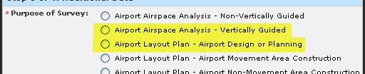
18 Example Table 2.1 Use Taxiway Construction
19
20 Scope of Work Practical Experience Review each feature and all associated attributes What is the intended source Who is responsible for obtaining it Does it need data conversion
21 Scope of Work Review Who handles submittals? Will reports be produced?
22 Scope of Work Review Address geodetic control Leaf-on or leaf-off imagery? What scale and extent?
23 Scope of Work Review What will be produced from each orthophoto resolution, planimetrics, offairport data, etc. Are there any existing construction projects or other airfield issues that might impact the timing of the imagery collection?
24 Scope of Work Review What survey is included? Identify notapplicable tasks explicitly
25 Scope of Work Review Include maps and graphics to clearly communicate the areas of interest What runways will be treated as verticallyguided?
26 Scope of Work Review Define e topographic deliverables Topographic data is expensive clearly delineate the expected coverage
27 Scope of Work Review Address planimetrics and include an attached spreadsheet for all features and attributes Consider phasing the project and providing interim deliverables
28 Scope of Work Review Do not ignore attribution and conversion to GIS format Attribute details covered in the attached spreadsheet
29 Scope of Work Review Utilities data might be limited, and be sure to identify the expected quality (most likely SUE Level D ) Manage expectations on collecting surrounding cadastral data if there are desired datasets, identify them clearly
30 Scope of Work Review Identify data that might be lessaccurate Phased Deliverables
31 Scope of Work Review Final phase for the planning work (surfaces) and proposed development no survey required here If hardcopies are If hardcopies are desired, be sure to address them
32 Scope of Work Review Important assumptions: HW / SW Website Mgmt Boundary Survey Training AC Changes Others!
33 Overall Work Flow of Participating in the Program PROJECT IMPLEMENTATION
34 Setting Roles and Responsibilities Who is Creating the Project? Responsible for Interacting with the FAA Website? Creating the Statement of Work and Other Plans? Conducting Surveys? Collecting Aerial Photography, If Necessary? Converting and Preparing Data? Uploading Deliverables to the FAA? Managing g the Grant?
35 Statement-of-Work Framework Components FAA/Airport Agreement Background & Objective Written from Airport Perspective Safety-Critical Data Not Consultant Scope of Requirements Services Plans NGS Compares Plans to Geodetic Control SOW Imagery See Online Help Survey & QC Templates Features Pre Coordinate with As-Built Data ADO Graphic RW Extension, with or w/o


36 Existing Data Airports GIS If Accepted by NGS (Sponsor Download) NGS/UDDF If Surveyed (NGS Website) FAA/AVN If Approach exists (FAA/AVN Website Airport Data -
37 Overall Work Flow of Participating in the Program FAA / NGS VALIDATION
38 VALIDATION / VERIFICATION
39 Review, Verification, Validation and Acceptance Expectations Task Statement-of-Work Plans Stereo Imagery Data Expectations 1 Week 2 Weeks 1 Month 1 Month NGS Independently Verifies Safety-Critical Data (Runway Coordinates, Profile, NAVAIDS, Obstacles, etc.)


40 Establishing Geodetic Control PACS/SACS 1 PACS/2 SACS - Standard Configuration 1 PACS Minimum Configuration Can support Multiple PACS/SACS systems at large airports - if justified. Evaluate installation benefits if unusual geological conditions exist Usually cost beneficial Recommendations Establish PACS/SACS in Development project/grant as additional scope Coordinate with Regional ADO representative on preferred locations Separate Airports GIS Project Airside Construction Geodetic Control Plans required only when establishing PACS/SACS


41 Temporary Geodetic Control Meets accuracy requirements Utilize in Planning project if permanent control does not exist Identify as Plan B in Statement- of-work if existing permanent Control cannot be recovered
42 FAA Airports GIS Program FAA Survey Requirements AC 150/ b Preparation of required descriptions, sketches, photographs, and other documentation. PENCIL RUBBINGS. Rubbings are not required during the recovery of a survey mark. However, rubbings are required at the time of each observation at that station See sample Below
43 FAA Airports GIS Program FAA Survey sample Form AC 150/ b 3) photograph type three should be taken horizontally with the station approximately 10 to 30 feet in the distance


44 AC 150/ B 17B Imagery Required for ALP Updates and Instrument Procedure Development (AC 150/ , Table 2-1) Not Required for general airside/landside construction projects
 Ground Sample Distance (GSD) 10-30 cm (4-12 in.")
45 Requirements The imagery should be flown at an altitude providing for usability of the imagery beyond the scope of the current project, such as future engineering or planning. Flying height less that 12,000 feet Above Ground Level (AGL) Ground Sample Distance (GSD) cm (4-12 in./pixel) Generally, Multiple flight levels if project includes off-airport obstacle y, p g p j p analysis
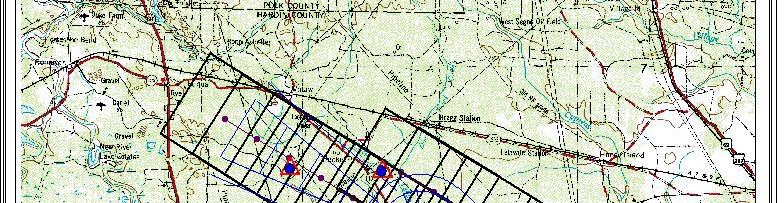
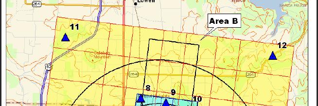
46 Flightline and Control Diagram Recommend to Include Imagery Area(s) in Statement-of-Work
47 NGS Verification
48 Waivers FAA Approves any Waiver request Pre Coordinate with Regional FAA Representatives Region must Coordinate all waivers with AAS-100 Have waived Full Foliage with Airport provided documentation Included Airport documentation in Statement-of-Work
49 LiDAR LiDAR is not acceptable for obstacle analysis Airborne LiDAR may be used to develop a Digital Terrain Model (DTM) to cost effectively develop ground contours after coordination with Regional Office and AAS-100 Ground based (stationary or mobile) is being evaluated to capture runway surface and other terrain data (Coordinate with Regional Office and AAS-100)
50 AC 150/ B Survey AC 150/ B Survey Requirements and GIS Schema

: 315 pages Appendices")

, Verification vs.")


51 Quality Control and Data Model 480 Pages! Chapter 1-4: 105 pages Chapter 5 (Data Model): 315 pages Appendices Safety-Critical Data Table 4-1 Runways, NAVAIDS, Obstacles, Geospatial (Profiles, Elevation, ARP), Verification vs. Validation Accuracy and Reporting Criteria i Table 2-1 Object Identification Surfaces Vertically Guided Approaches Non VG Approaches Statement-of-Work, Implementation Plans Data Translation, Use of Existing Data & Data Migration Tool GIS Schema (Data Model)


52 Vertically Guided Object Identification Surfaces LPV and ILS Approaches require use of Vertically Guided Object Identification Surfaces (-18B, Sect ) One set of object identification surfaces per runway - not approach-end dependent and Horizontal and Conical Surfaces not combined into an Airport surface Airport Airspace Analysis (object identification) requires Airport Elevation and ARP, therefore AAA for a runway requires information about all other runways.

53 FAA Airports GIS Program FAA Requirements AC 150/ b Deliverables -18B is not a graphic version of a Hardcopy ALP Which Version is correct?
54 FAA Airports GIS Program FAA Requirements AC 150/ b Deliverables -18B is not a graphic version of a Hardcopy ALP Which Version is correct? None Line 18B graphics make a terrible Hardcopy ALP


")
55 Airport GIS Website GS G Controls Workflow Project Statemement-of-Workt t Plans Data Reports Approvals Airport Operator Must Create Project (can be delegate State Agency though Letter-of-Authorization May (usually) assign Representatives (Consultants) to act in their behalf
56 Overall Work Flow of Participating in the Program MAINTAINING DATA


57 Data Maintenance Requirements and Best Practices Grant/PFC AC List Require Airports GIS as-builts datasets for most projects Request GIS Data for tenants t prior to issuing a Certificate of Occupancy Grant Assurance 29
58 Deliverables must go through a procedure
59 Maintaining Data Tools for Maintaining Data Data Submittal Standards Data QC / QA Procedures Contract Language for Deliverables (GIS!) Conditional Payment Clauses Contractor Upload-to-FAA Requirements Not just for as-builts ex: Pavement Design
NGS Aeronautical Survey Training 4/25/2013
 NGS NOAA role / National in supporting Geodetic to Survey FAA Aeronautical Survey Program Quality Review in Support of the FAA Airports Surveying-GIS Program Mark Howard April 29 May 3, 2013 NYSAPLS Rochester,
COLUMBUS REGIONAL AIRPORT AUTHORITY S. Surveyor s Standards
 COLUMBUS REGIONAL AIRPORT AUTHORITY S Surveyor s Standards FEBRUARY 2018 TABLE OF CONTENTS Table of Contents...ii Section 1: Introduction... 1 Definitions... 1 Points of Contact (POC)... 1 For questions
NORFOLK INTERNATIONAL AIRPORT MASTER PLAN UPDATE SCOPE OF SERVICES
 NORFOLK INTERNATIONAL AIRPORT MASTER PLAN UPDATE SCOPE OF SERVICES The Norfolk Airport Authority ( the Authority ) has contracted the services of CHA Consulting and its team of subconsultants to prepare
Airport Master Plan Update (AMPU) Phase 2. Scope of Work
 Phase 2. Scope of Work") BST AMPU Phase 2 Scope of Work Page 1 of 19 Belfast Municipal Airport Belfast, Maine Airport Master Plan Update (AMPU) Phase 2 Scope of Work The intent of this project is to update the 1999 Belfast Municipal
BST AMPU Phase 2 Scope of Work Page 1 of 19 Belfast Municipal Airport Belfast, Maine Airport Master Plan Update (AMPU) Phase 2 Scope of Work The intent of this project is to update the 1999 Belfast Municipal
ORDINANCE NO INTRODUCED BY COUNCIL
 Public Service Committee Andrew Roberts, Chair ORDINANCE NO. 18-1 29 INTRODUCED BY COUNCIL AN ORDINANCE AUTHORIZING THE PROPER CITY OFFICIAL TO ENTER INTO A CONTRACT WITH CRAWFORD, MURPHY, AND TILLY INC.,
POLICY AND PROCEDURES MEMORANDUM - AIRPORTS DIVISION. General Processing of Modifications to Agency Airport Design and Construction Standards
 U. S. Department of Transportation Federal Aviation Administration Great Lakes Region Illinois, Indiana, Michigan Minnesota, North Dakota, Ohio, South Dakota, Wisconsin 2300 East Devon Avenue Des Plaines,
Raleigh Executive Jetport Master Plan Update SEPT 27, 2017
 Raleigh Executive Jetport Master Plan Update SEPT 27, 2017 Presentation Outline 1. Master Plan Purpose 2. Master Plan Process 3. Public Involvement Plan 4. Project Schedule Presentation Outline 1. Master
Request for Qualifications for Professional Services
 Yuma Yuma County Airport Authority 2191 E 32nd St, Ste 218, Yuma, AZ 85365 (928) 726-5882 PORT OF OPPORTUNITY January 4, 2019 Request for Qualifications for Professional Services Yuma International Airport
Constructing Airfield Pavements with Federal Funds
 Constructing Airfield Pavements with Federal Funds Presented to: 2017 South Dakota Airports Conference By: Carlton E. Lambiasi, P.E. Date: March 29, 2017 Presentation Objectives Discuss the different ways
Guidelines for Procurement of Professional Aerial Imagery, Photogrammetry, Lidar and Related Remote Sensor Based Geospatial Mapping Services
 Guidelines for Procurement of Professional Aerial Imagery, Photogrammetry, Lidar and Related Remote Sensor Based Geospatial Mapping Services EXECUTIVE SUMMARY These Guidelines were prepared by the ASPRS
A Case Study from Phoenix Sky Harbor. April 29, 2009
 Implementing ArcGIS Server as a Hub within an Enterprise Architecture A Case Study from Phoenix Sky Harbor International Airport Dave Feuer Dave Feuer April 29, 2009 Objectives of Aviation Geospatial Technology
Mapping with Drones. Key Considerations and Factors to Achieve Desired Accuracy
 JUNE 2017 Mapping with Drones Key Considerations and Factors to Achieve Desired Accuracy 2 Presentation Format 1. Introduction DroneView Technologies 2. Market Focus 2015 through Today 3. Outlook for 2017
FSBPA Chip Baumberger, Project Scientist Dustin Myers, UAV Coordinator Brent Gore, GIS Coordinator
 FSBPA 2018 Practical applications of drones (UAVs) for aerial mapping of beach and nearshore habitats & comparison to full-scale manned aircraft using GIS-based hardbottom classification Chip Baumberger,
LiDAR Data capture with sensor SPL100 in the Region of Navarra
 Víctor García, Tracasa LiDAR Data capture with sensor SPL100 in the Region of Navarra Workshop: Use of algorithms on big DEM s Tønsberg, 4 th April 2018 Company Presentation - Tracasa TRACASA is a public
Drone Surveying: The Complete Story
 Drone Surveying: The Complete Story NYSAPLS Friday Webinar Series December 1, 2017 Aerotas enables surveyors to map by drone More than: 60 clients, 600 drone surveys, 450 hours of field testing & training,
Defining & Completing the Planning Process
 Defining & Completing the Process How Sets the Stage for Project Development Presented to: By: Gina Mitchell, AICP Date: November 5, 2014 AirTAP: Airport Project Development Process - From Idea to Award
Drones Use in Forestry: Regulations, Applications, Considerations
 Drones Use in Forestry: Regulations, Applications, Considerations Regulations What is a Drone? Small unmanned aircraft system aka UAV, UAS, suas. Weight is greater than 0.5 lbs. and less than 55 lbs. including
General Services Administration (GSA) Federal Acquisition Service Authorized Federal Supply Schedule Price List
 Federal Acquisition Service Authorized Federal Supply Schedule Price List") General Services Administration (GSA) Federal Acquisition Service Authorized Federal Supply Schedule Price List GSA Advantage! On-line access to contract ordering information, terms and conditions, up-to-date
General Services Administration (GSA) Federal Acquisition Service Authorized Federal Supply Schedule Price List GSA Advantage! On-line access to contract ordering information, terms and conditions, up-to-date
Town of Chapel Hill, NC
 Town of Chapel Hill Pro Forma Business Plan Utility-Based Stormwater Management Program I-3 Basic Database Feasibility Introduction At the most basic level, the rate structure for a stormwater utility
Airport Safety. 5 th Annual AirTAP Fall Forum 10/15/08. Jesse Carriger Assistant Manager, Minneapolis ADO. Federal Aviation Administration
 5 th Annual AirTAP Fall Forum 10/15/08 Jesse Carriger Assistant Manager, Minneapolis ADO 1 Comprehensive Self Inspection Program Construction Safety 2 Airport Self Inspections A successful self-inspection
Aerial Thermal and Visual Inspection of Electric Lines with an Unmanned Aerial System Brandon Rench, CP
 2018 Aerial Thermal and Visual Inspection of Electric Lines with an Unmanned Aerial System Brandon EXECUTIVE SUMMARY Our client has 770 miles of electric Distribution and Transmission lines which provide
kg l Without Fuel
 l Link to online registration l Cost (in Euro) Electronic Chip (with National Registration Number) Is Required: l Indicate additional information (if any) that should be included on electronic chip l Authority
A web GIS Application for Project Tracking and Production Monitoring
 A web GIS Application for Project Tracking and Production Monitoring Xinsheng (Kevin) Zhang & Rob Tubello EarthData International 7320 Executive Way, Frederick, MD 21704 Abstract Using ESRI ArcIMS, ArcSDE,
Building an Enterprise GIS for SFO Then and Now
 Building an Enterprise GIS for SFO Then and Now Introduction Overhead View Humble Beginnings Organization Overhaul Technical Transformation Stakeholder Engagement Enterprise Implementation Next Destination
REQUEST FOR QUOTES: # LE
 REQUEST FOR QUOTES: #15-07-1391LE Navajo Division of Transportation Department of Airports Management ADOT GRANT #E5S2R - Independent Fee Estimate - Reconstruct Runway 15/33 (Approximately 2,000 x 75 )
Drones in Forestry: Regulations, Applications, and Considerations SESAF Conference Darian Yawn Paul Shepard
 Drones in Forestry: Regulations, Applications, and Considerations 2018 SESAF Conference Darian Yawn Paul Shepard About LMSS Forest Technology Solutions Provider Sales, Training, and Support Project Consulting,
DSS 500 with In-FlightOrtho Maximize Your Productivity!
 DSS 500 with In-FlightOrtho Maximize Your Productivity! : DSS 500 maximizes efficiency and productivity in aerial mapping with in-air georeferenced orthophoto production. capture everything. precisely.
Shutdown Requests. Gian Catano Contract Administrator December 17, 2014
 Shutdown Requests Gian Catano Contract Administrator December 17, 2014 1 Topics - Two types of Shutdown Requests: - Airside Shutdown Requests - System Shutdown Requests - What is required from the Contractor
Pangborn Memorial Airport I One Pangborn Drive I East Wenatchee, WA 98802
 TO: Planning Advisory Committee (PAC) Members RE: Pangborn Airport Master Plan PAC Kickoff Meeting #1 DATE: August 22, 2016 On behalf of the Pangborn Memorial Airport, I would like to invite you to serve
INTERTEK AIRPORT LIGHTING EQUIPMENT CERTIFICATION PROGRAM
 INTERTEK AIRPORT LIGHTING EQUIPMENT CERTIFICATION PROGRAM IESALC Government Contacts Spring Meeting Washington, DC May 4, 2017 Jeremy N. Downs, P.E. ALECP Program Administrator INTRODUCTION Purpose / Outline
12/04/15 AC 70/7460-1L CHAPTER 13. MARKING AND LIGHTING WIND TURBINES
 CHAPTER 13. MARKING AND LIGHTING WIND TURBINES 13.1 Purpose. This chapter provides guidelines for the marking and lighting of wind turbine farms. These guidelines are applicable to single wind turbines
OCWR DRONE PROGRAM LEA Technical Training Series December 4, 2018
 OCWR DRONE PROGRAM 2018 LEA Technical Training Series December 4, 2018 2 ENTERING THE DANGER ZONE 3 OVERVIEW History of OCWR s Drone Operations Upgrades in Drone Technology FAA Operating Rules FAA Remote
Federal Aviation FAA GUIDANCE Administration Contractor Quality Control SWIFT
 FAA GUIDANCE Contractor Quality Control SWIFT September 19-22, 2016 Minneapolis, Minnesota Greg Cline, FAA AAS -100 gregory.cline@faa.gov (202) 267-8814 Presentation Objectives Summarize work in Airports
Control Survey Procedures
 Chapter 13 Control Survey Procedures 13-01 General 13-02 Policy Control surveys establish a common, consistent network of physical points that are the basis for controlling the horizontal and vertical
QUALITY ASSURANCE PLAN OKLAHOMA DEPARTMENT OF HUMAN SERVICES ENTERPRISE SYSTEM (MOSAIC PROJECT)
") QUALITY ASSURANCE PLAN OKLAHOMA DEPARTMENT OF HUMAN SERVICES ENTERPRISE SYSTEM (MOSAIC PROJECT) MOSAIC Quality Assurance Plan v04.02 Prepared by: Approved by: QUALITY ASSURANCE PLAN APPROVALS QA/QC Program
QUALITY ASSURANCE PLAN OKLAHOMA DEPARTMENT OF HUMAN SERVICES ENTERPRISE SYSTEM (MOSAIC PROJECT) MOSAIC Quality Assurance Plan v04.02 Prepared by: Approved by: QUALITY ASSURANCE PLAN APPROVALS QA/QC Program
GPS & Drone Workshops
 GPS & Drone Workshops Rutgers University Inn, New Brunswick December 11-12, 2017 Presented by Discovery Management Group, LLC Co-sponsored by the Center for Remote Sensing & Spatial Analysis, Rutgers University
Manhattan Regional Airport Draft Environmental Assessment. Table of Contents
 Table of Contents Page 1 PURPOSE AND NEED... 1-1 1.1 Background Information...1-1 1.2 Activity Forecasts...1-2 1.3 Purpose and Need...1-2 1.3.1 RSA and ROFA...1-3 1.3.2 Crosswind Runway...1-3 1.3.3 Parallel
European Aviation Safety Agency European Technical Standard Order
 European Aviation Safety Agency European Technical Standard Order SUBJECT: ELECTRONIC MAP SYSTEMS FOR GRAPHICAL DEPICTION OF AIRCRAFT POSITION 1 - Applicability This ETSO gives the requirements that any
Cartographic Potential of New Technologies: Aerial Data Collection
 Old Dominion University ODU Digital Commons September 29, 2016: Adaptive Structures and Innovative Solutions Hampton Roads Sea Level Rise/Flooding Adaptation Forum 9-29-2016 Cartographic Potential of New
Using Imagery and LiDAR for cost effective mapping and analysis for timber and biomass inventories
 Using Imagery and LiDAR for cost effective mapping and analysis for timber and biomass inventories Mark Meade: CTO Photo Science Mark Milligan: President LandMark Systems May 2011 Presentation Outline
Runway Protection Zones: Incompatible Land Use Alternatives Analysis & Risk Assessment
 March 3rd, 2015 Runway Protection Zones: Incompatible Land Use Alternatives Analysis & Risk Assessment Matt Lee Vice President Landrum & Brown Cincinnati, OH Cody Meyer Consultant Landrum & Brown Cincinnati,
Drainage Report. New Braunfels Municipal Airport. Master Plan Update 2005
 Drainage Report Master Plan Update 2005 General The Texas Department of Transportation (TxDOT), Aviation Division, retained the consulting engineering team of Parkhill, Smith & Cooper, Inc. (PSC), to prepare
A Best Practice for the Implementation of a Pavement Management System For Small and Medium Airports
 A Best Practice for the Implementation of a Pavement Management System For Small and Medium Airports Architectural & Engineering Services Civil Engineering Directorate Airport Engineering ATR-045 Real
Advisory Circular. Precision Approach Path Indicator Flight Check
 Advisory Circular Subject: Issuing Office: Civil Aviation, Standards Document No.: AC 300-014 File Classification No.: Z 5000-34 Issue No.: 01 RDIMS No.: 11343347 Effective Date: 2016-07-27 TABLE OF CONTENTS
airsight NextGen Airfield Inspections
 airsight NextGen Airfield Inspections airsight takes airfield inspection services to the next level with the utilisation of light Unmanned Aerial Vehicles (UAV). airsight UAVs, equipped with a GPS and
AGENDA Aviation Committee April 2, :00 PM
 AGENDA Aviation Committee April 2, 2018 7:00 PM I. COMMUNICATIONS II. RESOLUTIONS, MOTIONS AND NOTICES 1. Resolution extending agreement with Loomacres Wildlife Management and authorizing advertisement
Controlled Flight Into Terrain Joint Safety Implementation Team. Implementation Plan for TAWS Improved Functionality
 Statement of Work: (SE-120R1) Controlled Flight Into Terrain Joint Safety Implementation Team Implementation Plan for TAWS Improved Functionality Controlled Flight Into Terrain (CFIT) - accidents, where
Follow up to the implementation of safety and air navigation regional priorities
 RAAC/15-IP/09 International Civil Aviation Organization 04/12/17 ICAO South American Regional Office Fifteenth Meeting of the Civil Aviation Authorities of the SAM Region (RAAC/15) (Asuncion, Paraguay,
Unmanned Aerial Systems
 2016 Southern Consultants Meeting Unmanned Aerial Systems How UAV s Are Helping Us Become More Profitable and Better Stewards of the Land Christian Brodbeck February 25, 2016 Information drives agriculture
Oregon Department of Transportation. Geographic Information Systems. Implementation Plan
 Oregon Department of Transportation Systems Implementation Plan January Introduction Access to information is the key component driving ODOT s GIS goals. Most forms of information can be related to a geographic
TABLE OF CONTENTS GRAHAM MUNICIPAL AIRPORT TXDOT CSJ NO. 1803GRAHM
 TABLE OF CONTENTS GRAHAM MUNICIPAL AIRPORT TXDOT CSJ NO. 1803GRAHM 1. REQUEST FOR QUALIFICATIONS SOLICITATION 2. EVALUATION CRITERIA 3. PROJECT DIAGRAM 4. AIRPORT LAYOUT PLAN 5. FORM AVN-550-(PLEASE BE
Regional Aerial Imagery Questionnaire Summary. San Diego Regional GIS Council Meeting April 11, 2013
 Regional Aerial Imagery Questionnaire Summary San Diego Regional GIS Council Meeting April 11, 2013 Background In March 2012 SANDAG, SanGIS, the NGA, the LECC and Regional Public Safety GIS worked out
REQUEST FOR QUALIFICATIONS FOR ON-CALL CIVIL ENGINEERING CONSULTING SERVICES MANCHESTER-BOSTON REGIONAL AIRPORT MANCHESTER, NH FY
 REQUEST FOR QUALIFICATIONS FOR ON-CALL CIVIL ENGINEERING CONSULTING SERVICES MANCHESTER-BOSTON REGIONAL AIRPORT MANCHESTER, NH SECTION 1.0 INTRODUCTION FY15-805-48 This Request for Qualifications has been
Unmanned Aircraft Systems (UAS) Capabilities and Expertise. Applications of UAS in the Water Resource Industry
 Capabilities and Expertise. Applications of UAS in the Water Resource Industry") Unmanned Aircraft Systems (UAS) Capabilities and Expertise Applications of UAS in the Water Resource Industry Alonso Morales Commercial UAS Pilot Joint Unmanned Systems Management Services March 23rd,
Unmanned Aircraft Systems (UAS) Capabilities and Expertise Applications of UAS in the Water Resource Industry Alonso Morales Commercial UAS Pilot Joint Unmanned Systems Management Services March 23rd,
BLAST INTERREG IV North Sea Region Program. Work Package 3 Developing the Marine & Coastal Reference Base. Summary Report
 BLAST INTERREG IV North Sea Region Program Work Package 3 Developing the Marine & Coastal Reference Base Summary Report Date: 20 th August 2012 Author: Rust, A M, Version R1r0 www.blast-project.eu 1 Authors
5.D.1 HISTORIC, ARCHITECTURAL, ARCHEOLOGICAL, AND CULTURAL RESOURCES
 5.D.1 HISTORIC, ARCHITECTURAL, ARCHEOLOGICAL, AND CULTURAL RESOURCES Section 106 of the National Historic Preservation Act (NHPA) of 1966, as amended (16 U.S.C. Section 470(f)) protects properties that
SCOPE OF WORK AND DELIVERABLES
 1.0 PROJECT OVERVIEW The State of Minnesota (State) has identified the need for the replacement of Bridge 5308, a railroad bridge that carries the Canadian Pacific Railroad (CP Rail) over Trunk Highway
Exhibit A Mn/DOT Contract No
 Exhibit A Mn/DOT Contract No. 98142 SCOPE OF WORK AND DELIVERABLES Preliminary Design Red Wing US 63 Bridge and Approach Roadways State Project (SP) 2515-21 SCOPE OVERVIEW... 2 SCHEDULE... 2 PROJECT TASK
REQUEST FOR QUALIFICATIONS UTILITY LAYOUT MAPPING AND PLAN OF RECORD AS BUILT DRAWINGS RFQ Q MR ADDENDUM #2 10:00 AM November 18, 2010
 REQUEST FOR QUALIFICATIONS UTILITY LAYOUT MAPPING AND PLAN OF RECORD AS BUILT DRAWINGS RFQ Q 10 019 MR ADDENDUM #2 10:00 AM November 18, 2010 This addendum notifies of changes to the due date, the estimated
2015 AIM Infrastructure And Quality Assurance People, Organization and Projects
 2015 AIM Infrastructure And Quality Assurance People, Organization and Projects Glenn M. Frieler P.E. DENVER INTERNATIONAL AIRPORT November 18 th, 2015 The AIM Organization Facilities Management Fleet
Layer Informatics is an International consultancy providing cost-effective and quality GeoSpatial solutions and services across
 .l a yer i n f o r m a tic s. co m Layer Informatics is an International consultancy providing cost-effective and quality GeoSpatial solutions and services across key sectors to government and private
Applying Surveying Expertise to become
 From Maps to Models Applying Surveying Expertise to become The Spatial Information Manager Mark Nichols Trimble Vice President Our History and Our Future from Maps to Models Technology changes have improved
Innovative Approach to Airfield Pavement Inspections and Distress Identification at Oakland International Airport. Submitted: December 8, 2014
 Innovative Approach to Airfield Pavement Inspections and Distress Identification at Oakland International Airport Submitted: December 8, 2014 to the 9 th International Conference on Managing Pavement Assets
Advantages of Using Laser Scan and UAV Technology in Virtual Asset Management
 Advantages of Using Laser Scan and UAV Technology in Virtual Asset Management Authors: Paul David Ramirez and George Mann Unmanned Ad-Hoc Industries, Inc. 519 E Oak Hill Dr, Spring, Texas 77386 www.globaluai.com
URBAN STORMWATER BMP DATABASE HISTORIC BMP RECORD REVIEW AND UPDATE SCOPE OF WORK
 URBAN STORMWATER BMP DATABASE HISTORIC BMP RECORD REVIEW AND UPDATE SCOPE OF WORK Background and Purpose The Anne Arundel County National Pollutant Discharge Elimination System (NPDES) Municipal Separate
Boston Overflight Noise Study. Phase 1 PROJECT CONSULTANT SCOPE OF SERVICES
 Phase 1 PROJECT CONSULTANT SCOPE OF SERVICES March 8, 2004 Project Consultant Phase 1 Scope of Services 3/8/2004 TABLE OF CONTENTS INTRODUCTION... 2 1 STUDY DESIGN... 3 2 PROJECT MANAGEMENT... 4 2.1 Project
Final Estimates Level 2. Module 5: Earthwork Computations
 Florida Department of TRANSPORTATION Final Estimates Level 2 Module 5: Earthwork Computations 11/1/2017 FDOT Final Estimates Level 2 Release 11, Module 5 1 5-1 Module Content Basic Earthwork Terminology
A Forest Cover Change Study Gone Bad
 A Forest Cover Change Study Gone Bad Lessons Learned(?) Measuring Changes in Forest Cover in Madagascar Ned Horning Center for Biodiversity and Conservation American Museum of Natural History (horning@amnh.com)
Web Based Pipeline Construction Management System. Web Based Infrastructure Monitoring & Management System. Web GIS. Web Solutions
 Wel Come INDIGENOUS AERONAUTICAL CHARTS WgCdr PK Mishra JPAC Technologies Pvt. Ltd. JPAC Technologies Pvt. Ltd Introduction Web Based Pipeline Construction Management System Web Based Infrastructure Monitoring
SAFEGUARDING. Aviation Consultancy at its best.
 SAFEGUARDING Aviation Consultancy at its best. Specialist aviation support to help solve problems for airports and airport developers SAFEGUARDING The safety of aircraft operations in the vicinity of an
AERIAL INSPECTIONS USING UNMANNED AERIAL VEHICLES
 AERIAL INSPECTIONS USING UNMANNED AERIAL VEHICLES MICHAEL A. PEREZ, WESLEY C. ZECH, PH.D., WESLEY N. DONALD, PH.D. MRN/SWANA MID-ATLANTIC A N N UA L C ONFERENCE ELLICOTT CITY, MD JUNE 22, 2016 Research
Pavement Update Track: Engineering
 Pavement Update Track: Engineering 2017 ACC Airports Technical Workshop June 21-22, 2017 Arlington, VA Gregory D. Cline, P.E. FAA Airport Engineering AAS-100 gregory.cline@faa.gov (202) 267-8814 Pavement
August 8, 2017 Community Engagement Panel Meeting #3 Alternatives Evaluation Process & Identification of Preferred Alternatives
 Lake Elmo Airport Environmental Assessment (EA)/ Environmental Assessment (EAW) Worksheet August 8, 2017 Community Engagement Panel Meeting #3 Alternatives Evaluation Process & Identification of Preferred
Drone Basics 101 Technology, Regulations and Project Examples. Tom Gehrdes & Alton Whittle
 Drone Basics 101 Technology, Regulations and Project Examples Tom Gehrdes & Alton Whittle What are UAVs? Unmanned Aerial Vehicles (UAVs) are remotely operated aircraft that fly without the possibility
In partnership with. Sponsors
 3rd Annual AUVSI Student UAV Competition In partnership with Sponsors 2005 MISSION, SCORING AND RULES OBJECTIVE The goals of this competition are to challenge a new generation of undergraduate university
GPS: Using your Mobile Device for High-Precision GPS Data Collection. UAV: Do-It-Yourself Accurate Drone Mapping in Natural Resources
 GPS: Using your Mobile Device for High-Precision GPS Data Collection UAV: Do-It-Yourself Accurate Drone Mapping in Natural Resources GPS: March 7, 2018 Coeur d Alene Resort UAV: March 8, 2018 Coeur d Alene
FAAWaiverWallet - Drone Deploy App - User Guide SUMMARY
 SUMMARY Applying for an FAA Waiver? FAAWaiverWallet.com is the easiest way to complete, track, and store your FAA Waiver Requests. Use our templates and process to keep organized. Get notified and avoid
Implementation and maintenance of the Land Parcel Identification System in Bulgaria. Dimitris Kapnias
 Implementation and maintenance of the Land Parcel Identification System in Bulgaria Dimitris Kapnias EUR 23691 EN - 2008 The Institute for the Protection and Security of the Citizen provides research-based,
ENTERPRISE DREDGE (edredge): A DREDGING BUSINESS PRACTICE ENTERPRISE GIS APPLICATION
: A DREDGING BUSINESS PRACTICE ENTERPRISE GIS APPLICATION") ENTERPRISE DREDGE (edredge): A DREDGING BUSINESS PRACTICE ENTERPRISE GIS APPLICATION L.S. Lillycrop 1 and R. Dopsovic 2 ABSTRACT Implementation and management of US Army Corps of Engineers (USACE) dredging
ENTERPRISE DREDGE (edredge): A DREDGING BUSINESS PRACTICE ENTERPRISE GIS APPLICATION L.S. Lillycrop 1 and R. Dopsovic 2 ABSTRACT Implementation and management of US Army Corps of Engineers (USACE) dredging
Proactive Airport Pavement Management: The Tools Are Available
 Proactive Airport Pavement Management: The Tools Are Available Prepared for the ICAO-ACI/LAC Conference Lima, Peru November 2003 By Frank B. Holt Vice President Dynatest International A/S Types of Evaluations
SUSQUEHANNA AREA REGIONAL AIRPORT AUTHORITY
 SUSQUEHANNA AREA REGIONAL AIRPORT AUTHORITY REQUEST FOR QUALIFICATIONS Professional Construction Management Services Harrisburg International Airport Rehabilitate Runway 13-31 Susquehanna Area Regional
East Central College
 SECTION 013200 - CONSTRUCTION PROGRESS DOCUMENTATION PART 1 - GENERAL 1.1 RELATED DOCUMENTS A. Drawings and general provisions of the Contract, including General and Supplementary Conditions and other
Risk MAP Exploratory Innovation Projects. ASFPM 2017: Kansas City, MO Tuesday, May 2, 2017
 Risk MAP Exploratory Innovation Projects ASFPM 2017: Kansas City, MO Tuesday, May 2, 2017 Project Themes and Focus Explore Build Finish 2 What are these Innovation Projects? A project (data analysis, research,
JOB DESCRIPTION. Manager, Ocean and Coastal Geoscience. Director Geoscience. Manager, Ocean & Coastal Geosciences. Senior Geodetic Surveyor.
 JOB DESCRIPTION Job Reference: Job Title: Work Unit: Responsible To: Responsible For: Job Purpose: Senior Geodetic Surveyor Ocean & Coastal Geoscience Sector of Geoscience for Development Programme (Geoscience
GPS: Using your Mobile Device for High-Precision GPS Forestry Data Collection UAV: Do-It-Yourself Accurate Drone Mapping in Natural Resources
 Back-to-back workshops at convenient locations GPS: Using your Mobile Device for High-Precision GPS Forestry Data Collection UAV: Do-It-Yourself Accurate Drone Mapping in Natural Resources Each location
Prepared by BC Fisheries Information Services Branch for the Resources Inventory Committee. March Version 1.0
 Reconnaissance (1:20 000) Fish and Fish Habitat Inventory: Quality Assurance Procedures Prepared by BC Fisheries Information Services Branch for the Resources Inventory Committee March 2000 Version 1.0
Black Hawk County Primary Geodetic Control Network
 Black Hawk County Primary Geodetic Control Network Identification_Information Data_Quality_Information Spatial_Data_Organization_Information Spatial_Reference_Information Entity_and_Attribute_Information
Federal Aviation Administration
 U.S. Department of Transportation Federal Aviation Administration DRAFT Environmental Impact Statement for Proposed Redevelopment and Extension of Runway 9R/27L March 30, 2007 Fort Lauderdale-Hollywood
SOLAR DEVELOPMENT DRONE SITE MAPPING
 SOLAR DEVELOPMENT DRONE SITE MAPPING SOLUTION SNAPSHOT Measure s comprehensive data reports provides site developers with the actionable data they need to identify sites primed for solar development and
150/ G Versus 150/ H Contractor Quality Control Program
 AC 150/5370-10G AC 150/5370-10H 1 Part 1 of General Provisions Part 2 of General Construction Items 2 Section 100 Item C-100 3 Quality Control Program (CQCP) 4 100-01 General. When the specification requires
TECHNICAL CONTENT PROPOSED STEEP SLOPE REGULATION
 1 TECHNICAL CONTENT PROPOSED STEEP SLOPE REGULATION Draft 2/08/10 (Revised 02-14-11,Revised 02-21-11, Revised 03-03-11, Revised 04-19-11, Revised 04-20-11, Revised 05-05-11, Revised 05-09-11). DEFINITIONS
Rick Lake, President Rob Andrews, Quality Control Manager
 Rick Lake, President Rob Andrews, Quality Control Manager Who we are The Western Utility Group was established 30 years ago. Since moving into locating over 15 years ago, we have built valuable relationships
FORESTS FOR TOMORROW PILOT PROJECT FINAL SYNOPSIS
 FORESTS FOR TOMORROW PILOT PROJECT FINAL SYNOPSIS Identification and prioritization of backlog openings for incremental silviculture investment opportunities using remote sensing techniques Proponent Name:
Runway Safety and Pedestrian Ground vehicles/ Public Protection
 Runway Safety and Pedestrian Ground vehicles/ Public Protection Presented at the Aerodrome Certification Workshop in Dominican Republic Presented by: FAA 1 Presentation overview 139.329: Pedestrian and
150/5380-7B, Airport Pavement Management Program (PMP)
") DRAFT Advisory Circular 150/5380-7B, Airport Pavement Management Program (PMP) 2014 ACC AIRPORTS TECHNICAL WORKSHOP July 29-30, 2014 Arlington, VA Greg Cline, FAA AAS -100 gregory.cline@faa.gov (202) 267-8814
DRAFT Advisory Circular 150/5380-7B, Airport Pavement Management Program (PMP) 2014 ACC AIRPORTS TECHNICAL WORKSHOP July 29-30, 2014 Arlington, VA Greg Cline, FAA AAS -100 gregory.cline@faa.gov (202) 267-8814
Use of Unmanned Aerial Vehicles (UAVs) in Impact Assessment. IAIA, Florence, Italy, April 2015
 in Impact Assessment. IAIA, Florence, Italy, April 2015") Use of Unmanned Aerial Vehicles (UAVs) in Impact Assessment IAIA, Florence, Italy, April 2015 EIA Context EIA is essentially a predictive process that informs decision making Institutionalisation: 191
Use of Unmanned Aerial Vehicles (UAVs) in Impact Assessment IAIA, Florence, Italy, April 2015 EIA Context EIA is essentially a predictive process that informs decision making Institutionalisation: 191
CHAPTER 2 THE PROPOSED ACTION
 CHAPTER 2 THE PROPOSED ACTION 2.0 INTRODUCTION The proposed action(s) must ensure that the Afton Lincoln County Airport complies with minimum FAA and WYDOT design recommendations for a parallel taxiway
Sustaining Member Application
 Sustaining Member Application ASPRS: The Imaging & Geospatial Information Society Our ASPRS sustaining membership has been very valuable to SAIC, because ASPRS provides a unique and open forum for exchange
STATE UNIVERSITY CONSTRUCTION FUND Concept Phase Checklist
 STATE UNIVERSITY CONSTRUCTION FUND Concept Phase Checklist The following checklist shows the general items required by the Agreement and the Program Directives. Unless included in the lump sum fee or the
ESSENTIAL CONSIDERATIONS FOR DRONE OPERATION.
 GET TING A SAFER B IR DS - E Y E VIEW: ESSENTIAL CONSIDERATIONS FOR DRONE OPERATION. www.cna.com Table of Contents Introduction... 2 Know Who s Up In the Air... 3 Drones by the Numbers... 3 Understand