Asset Management and Data Collection using Digital Video / GPS Data Extraction Techniques
|
|
|
- Samson Sanders
- 6 years ago
- Views:
Transcription
1 Asset Management and Data Collection using Digital Video / GPS Data Extraction Techniques TRB 6 th National Conference on Transportation Asset Management Kansas City, Missouri November 2, 2005
2 Presentation Overview Case Study / Problem Statement Review Asset and Data Collection Selection Method Data Collection Project Execution Digital Video Field Survey Digital Video Asset Extraction Benefits Other Uses

3 Case Study Regional Municipality of Halton, Ontario, Canada 967 square km Region / County Network Four local municipalities Population ,000 Regional Road System 312 Centre line km of Roadway 842 Lane Km of Roadway 212 Traffic Signals 167 Un-signalized Intersections
4 Problem Statement 2003 Transportation Services Department implements a Transportation Data Model (I.e. data dictionary) to maintain Infrastructure data for the Regional Road Network Right of Way DATA IS REQUIRED TO FUEL THE ENGINE Development and implementation of a process to determine what data is required and what is the best method for field data collection Cataloging existing data sources (paper/mylar/cad/gis) Reviewing Detailed Data Requirements Consultant Retention Data Gap Analysis Workshop with all users Establish rules/relationships/linear referencing Approach to execution of data collection
5 Transportation Data Model Assets and Data Collection Phasing Phase Asset Phase Asset 1 Guide Rail 2 Access 1 Intersection 2 Boulevard 1 Marking Line 2 Bridge 1 Marking Point 2 BusStop 1 Marking Poly 2 Curb / Gutter 1 Master Controller 2 Hand Hole 1 Median 2 Inlaid Delineater 1 Number Of Lanes 2 Landscape Area 1 Pole 2 Loop Detector 1 Sign Location 2 No Parking 1 Sign Placement 2 No Passing 1 Sign Type 2 No Stopping 1 Street Centreline 2 No Trucks 1 Street Light 2 No Turns 1 Traffic Controller 2 Pavement 1 Traffic Signal 2 Railway Crossing 2 Recreational Path 2 Road Speed 2 Sidewalk 2 Wall
6 Phase 1 Assets Data Collection Selection Methodology Data Requirements Complete, accurate (sub metre) and current geometry/attribute Integration with Transportation Data Model Reviewed data collection selection methods Digitization Handheld GPS Mobile Digital Video Survey Advantages and Disadvantages were compared
7 Data Collection Method Selection Method Description Data Sources Advantages Disadvantages Digitization Tracing/Digitizing Tablet On-screen Digitizing CAD Drawings/Mylar s/ Paper Maps / Orthophotography Labour costs Timeframe Data currency Positional accuracy Hand Held GPS Mobile Digital Video Imagery Field Data Collection In office data compilation Mobile Collection Digital Video Imagery / In office data extraction and GPS Data compilation GPS Unit/Field Staff Accuracy control Safety Resource intensive Weather/satellites Attribute collection Positional accuracy Attribute accuracy Immediate Inventory No field revisits Weather Cost of technology if purchased
8 Data Collection Method Selection Scoring Matrix A scoring matrix was established for each transportation infrastructure asset with respect to the data collection methods Code Rating 1 Not achievable 2 Intensive 3 Accom plishable 4 Good 5 Optim al m ethod Each asset was given a rating based on on the ability to capture the geometry/attribute requirements
9 Data Collection Selection Method Return on Investment An example of the matrix Mobile Digital Video Survey Mobile Digital Video Survey Handheld Handheld Digitize Digitize GPS GPS Phase Asset Feature Type Geometry Attribute Geometry Attribute Geometry Attribute 1 Guide Rail Geometry/Attribute Intersection Geometry/Attribute Marking Line Geometry/Attribute Marking Point Geometry/Attribute Marking Poly Geometry/Attribute Master Controller Geometry/Attribute Median Geometry/Attribute Number Of Lanes Geometry/Attribute Pole Geometry/Attribute Sign Location Geometry/Attribute Sign Placement Attribute Sign Type Attribute Street Centreline Geometry/Attribute Street Light Geometry/Attribute Traffic Controller Geometry/Attribute Traffic Signal Geometry/Attribute
10 Data Collection Selection Method Mobile Digital Video Survey satisfied the geometry/attribute needs for Phase 1 data to be collected Project timelines, resources and extra benefits weighed into the final selection method Next step EXECUTE THE PROJECT


11 Mobile Digital Video Survey Work Plan Equipment Preparation Define Data Models Field Data Collection GPS Post Processing Feature Extraction QA / QC
12 Mobile Digital Video Survey Data Flow Mechanism to collect transportation assets along the Regional Road Network Right of Way Video Data Server Field Surveys Video and GPS Capture Software AVI GPS Digital Video/Images (AVI/JPG) AVI JPG ODBC QA/QC ArcMap Desktop Software Asset Positioning Through Video Analysis ODBC Central Database Access 2000 ODBC GIS Manipulation ArcMap ESRI SHP AVI To Halton Image Viewing Software ESRI SHP Digital Video
 Vehicle Dynamics (increased accuracy and positioning) 45")
13 Mobile Digital Video Survey Equipment Preparation Equipment Calibration for: Camera Orientation (for positioning assets) Vehicle Dynamics (increased accuracy and positioning) 45 o 45 o GPS


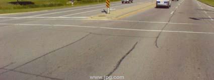
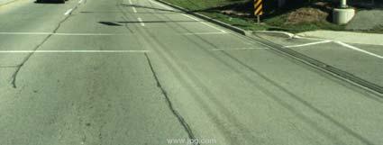
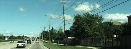
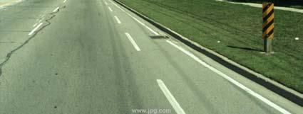
14 Mobile Digital Video Survey Field Surveys Left Camera Digital Video Survey (3 metre intervals) Right Camera D I R E C T I O N O F T R A V E L
15 Mobile Digital Video Survey GPS Post Processing Temporary GPS Base Station setup in the centre of the Region All real time corrected data was further post processed through proprietary software that implement vehicle dynamics into the post processing algorithm Result was a vehicle GPS trace data accurate to 1.5 feet 100% of the time

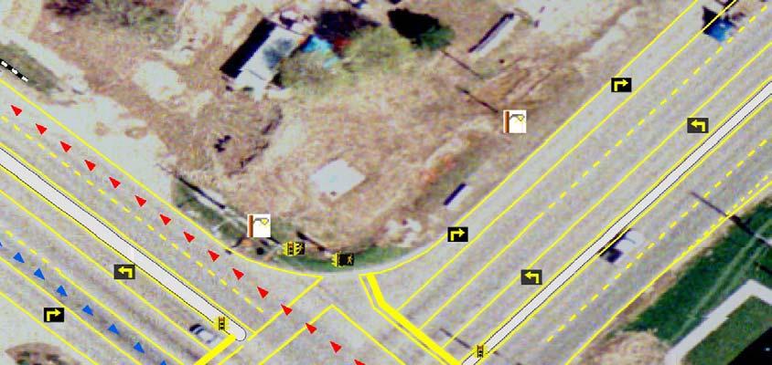
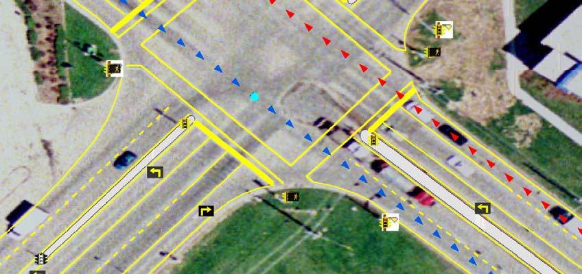
16 Asset Extraction Data Inventory Attribute Data/ Relationships Lon Lat Alt
17 Asset Extraction - QAQC
18 End Product Data Collected: 600 Guide Rails 6000 Marking Lines 1700 Marking Points 40 Marking Polygons 300 Medians 4400 Poles 3400 Street Lights 7000 Sign Locations Signs 2500 Traffic Signals 1400 Lane Attributes GIS Transportation Infrastructure Database Public Works / Asset Management Immediate Safety Maintenance Needs Full Video Log of Network (Liability Issues) Pavement Management Program Engineering (Preliminary Design)
19 Benefits Realized Accurate Geo-referenced High Resolution Digital Image archive of the road network Visuals for public presentations Customer complaint review feedback tool Reduced field visits Dataset for emergencies Dataset to catalogue and remove illegal signs Dataset for non-transportation assets within the ROW (Hydro Line Crossings and Fire Hydrants) AVI integration with ESRI software
20 Summary of Data Use Asset Management (Planning) Urgent Safety Requirements ADA Obstruction / Compliance Study s E911 Systems Sustainable Asset Management
21 Asset Type Asset Component Quantity Unit Value Replacement Value Roads Expressway 46 km $833 /km $39,000,000 Rural Arterial 71 km $335 /km $24,000,000 Rural Collector 787 km $285 /km $224,000,000 Rural Local 195 km $285 /km $55,000,000 Urban Arterial (minor) 167 km $1,319/km $221,000,000 Urban Arterial (major) 253 km $1,984 /km $504,000,000 Urban Collector 378 km $1,237 /km $467,000,000 Urban Local 845 km $1,193 /km $1,000,000,000 Bridges/ Culverts 352 $1,000,000 each $352,000,000 Sidewalks 2,270,000 m $100 /m $227,000,000 Traffic Signals traffic 470 $90,000 each $42,000,000 Signals - pedestrian 350 $40,000 each $14,000,000 Street lights arm & luminaire 35,979 $500 each $18,000,000 Streetlights poles & luminaire 2,241 $2,500 each $6,000,000 Signs 250,000 $150 each $38,000,000 Pavement Markings 2,743,985 m $2 /m $5,000,000 $3.2 billion
22 Financial Analysis Construction Costs $ $1,300,000,000 Average per 5 years $ 151,050,983 Average per annum $ 30,210, years Growth 2.5% $ 6,800,000 Engineering cost 15% Contingency 10% $ $ 208,000, ,000, % per annum Overhead & Admin 10% $ 69,000,000 Borrowing Costs 20% $ 900,000,000 Total Capital Requirements $ 2,600,000,000 $ 244,919,865 Average per annum $ 48,983,973 O & M 1.0% $ 861,000,000 Overhead & Admin 10% $ 86,100,000 Cost Allocations 2% Total O & M $ 824,000,000 $ 319,260,565 Average per annum $ 63,852,113 $ 43,000,000 Total O&M + Capital $ 3,400,000,000 $ Average per annum $ 163,000,000 Additional Contribution to Reserves Total Revenue Requirements Average per 5 years $ 564,180,430 Average per annum $ 112,836,086 Sustainable Funding Level
23 Revenue Requirements Roads Average Annual Requirement = $163,000, $ (millions)
24 Expenditure Revenue Reserve Fund Plan Plan Plan Water Water Average Annual Requirement = $117,000, $ (millions)
25 Communications Tools
26 Asset Replacement Value per 50 property frontage Total Value = $65,500 Fleet - $775 Roads - $23,400 Solid Waste - $690 Transit $950 Parks & Open Spaces $1,600 Public Buildings - $4,600 Storm - $6,250 Sanitary & Combined - $13,600 Water - $13,500
27 Impact on Rate & Levy Programs Life Cycle Projections (years) 2005 Budget ($M) Sustainable Budget ($M) Deficit ($M) Impact Rate Programs Water (12) 12% Sanitary (4%) Storm (19) 19% Levy Programs Roads (41) 8% Waste Management 50 27* 37 (10) 2% Facilities & Open Spaces (8) 2% Transit (8) 2% Fleet (13) n/a * excludes SWMMP initiatives
28 Household Daily Cost Coffee & Bagel Milk Fleet Facilities & Open Spaces Transit Waste Mgt Roads Storm Wastewater Water $/day Current Daily Cost per Household Sustainable Daily Cost per Household
29 Questions?
CITY OF WINDSOR Municipal Performance Measurement Program (MPMP) 2011 RESULTS 1.1 GENERAL GOVERNMENT - EFFICIENCY 3.7% 4.7%
 2011 RESULTS 1.1 GENERAL GOVERNMENT - EFFICIENCY 3.7% 4.7%") Local Government 1.1 a) Operating costs for governance and corporate management as a percentage of total municipal operating costs. 1.1 b) Total costs for governance and corporate management as a percentage
Local Government 1.1 a) Operating costs for governance and corporate management as a percentage of total municipal operating costs. 1.1 b) Total costs for governance and corporate management as a percentage
Transportation Asset Management Plan. Shannon Foss Asset Management Planning Director Met Council: Funding & Programming Committee May 17 th, 2018
 Transportation Asset Management Plan Shannon Foss Asset Management Planning Director Met Council: Funding & Programming Committee May 17 th, 2018 mndot.gov 2 Timeline 2014: Pilot TAMP Completed April 30
CHAPTER 12 INSTALLATION OF UTILITIES AND OTHER SYSTEMS TABLE OF CONTENTS
 CHAPTER 12 INSTALLATION OF UTILITIES AND OTHER SYSTEMS TABLE OF CONTENTS Section Title Page 12.1 General... 12-1 12.2 Design Standards... 12-1 12.2.1 General Requirements...12-1 12.2.2 Minimum Depth...12-1
Implementing an Asset and Pavement Management System in Alexandria, VA. Craig Schorling, GISP Business Development Manager, Transmap Corporation
 Implementing an Asset and Pavement Management System in Alexandria, VA Craig Schorling, GISP Business Development Manager, Transmap Corporation Alexandria Statistics Located on the Western bank of the
FIG2006 Automated Road Sign Inventory Solution. Presenter: : Claude Laflamme Director of R&D
 FIG2006 Automated Road Sign Inventory Solution Presenter: : Claude Laflamme Director of R&D PRESENTATION OVERVIEW Geo-3D Introduction System components Data Extraction Detection Recognition Results Applications
Highways Asset Management
 Highways Asset Management Bruno Peters (bpeters@ibigroup.com) David Kamnitzer (dkamnitzer@ibigroup.com) ITS / STI Canada - Conférence annuelle 2012 Name of Presentation Many definitions of highway asset
2006 GIS-T T Symposium Columbus Ohio
 2006 GIS-T T Symposium Columbus Ohio Paving the Way to a Robust GIS Managing countywide transportation asset data in St. Johns County, Florida County Objectives Complete and accurate inventory of transportation
CHAPTER 3 SCOPE SUMMARY
 CHAPTER 3 SCOPE SUMMARY GENERAL The SDDOT is an active member of AASHTO to share common national design standards for the state highway system. The AASHTO Task Force on Geometric Design has completed the
City of Victoria Aging Infrastructure Review and Assessment
 City of Victoria Aging Infrastructure Review and Assessment Presented by Engineering and Public Works Department February 2012 Presentation Outline Infrastructure Definition and Examples City of Victoria
Esri Roads and Highways An Introduction. Nathan Easley Rahul Rakshit
 Esri Roads and Highways An Introduction Nathan Easley Rahul Rakshit Roads and Highways Linear Referencing for the Transportation Enterprise GIS-enabled LRS platform LRS management LRS editing & maintenance
For Public Input Period
 20142018 CAPITAL IMPROVEMENT PLAN ( Thousands) CITY OF HOUSTON STREET & TRAFFIC CONTROL Project: Kingwood Drive N100011 Loop 494 to Woodland Hills Project Description Project provides for the ROW acquisition,
TABLE OF DRAWINGS. Pierce County Public Works & Utilities
 Section A Concrete and Asphalt Concrete Pavement and Roadway Sections PC.A1.1 Arterial with Cement Concrete Traffic Curb and Gutter and Sidewalk, Closed Drainage 05/10/2018 PC.A1.2 Arterial with Cement
Urban Arterial Roads Pavement Data Collection. October 23, 2012 Todd M. Halacy, P.E. VDOT Local Assistance Division
 Urban Arterial Roads Pavement Data Collection October 23, 2012 Todd M. Halacy, P.E. VDOT Local Assistance Division Presentation Topics Background Information: CTB Subcommittee & Local Government Workgroup
TABLE OF DRAWINGS. Pierce County Public Works & Utilities
 Section A Concrete and Asphalt Concrete Pavement and Roadway Sections PC.A1.1 Arterial with Cement Concrete Traffic Curb and Gutter and Sidewalk, Closed Drainage 04/01/2019 PC.A1.2 Arterial with Cement
City of DeBary, FL Sidewalk Data Collection Services
 City of DeBary, FL Sidewalk Data Collection Services Prepared by: Data Transfer Solutions, LLC 2680 Avalon Park Blvd. East, Suite 200 Orlando, FL 32828 www.dtsgis.com 1 COVER LETTER May 30, 2017 Mr. Matt
Asset Management Fundamentals
 Asset Management Fundamentals Work Management includes all of the scheduling and activities involved in maintaining assets at a predefined condition level, including: Work Orders Work Requests Maintenance
Creative Ways to better Manage your Infrastructure, new and emerging Technology. Karen Stewart Esri Canada
 Creative Ways to better Manage your Infrastructure, new and emerging Technology Karen Stewart Esri Canada Traffic camera Electric wiring Information portal Road signage Viaduct Traffic sign Canal Fleet
Final Report 2014 Addendum
 Final Report 2014 Addendum Supplemental ADA Transition Plan Inventory of Public ROW Facilities Prepared by: August 2014 Table of Contents Executive Summary...1 Introduction...2 Inventory Methodology...2
Tacoma Mall Office Building 4301 South Pine Street, Suite 446 Tacoma, Washington (253) Fax (253)
 Fax (253)") Tacoma Mall Office Building 4301 South Pine Street, Suite 446 Tacoma, Washington 98409-7207 (253) 798-7250 Fax (253) 798-4233 www.piercecountywa.org/roadstandards March 2012 Foreword This manual contains
Tacoma Mall Office Building 4301 South Pine Street, Suite 446 Tacoma, Washington 98409-7207 (253) 798-7250 Fax (253) 798-4233 www.piercecountywa.org/roadstandards March 2012 Foreword This manual contains
Municipality of Central Manitoulin
 Municipality of Central Manitoulin Municipal Asset Management Plan December 31 st, 2013 Asset Management Planning for the Municipality of Central Manitoulin Table of Contents The contacts in connection
Tacoma Mall Office Building 4301 South Pine Street, Suite 446 Tacoma, Washington (253) Fax (253)
 Fax (253)") Tacoma Mall Office Building 4301 South Pine Street, Suite 446 Tacoma, Washington 98409-7207 (253) 798-7250 Fax (253) 798-4233 www.piercecountywa.org/roadstandards March 2012 Comment Form Date: To: From:
Tacoma Mall Office Building 4301 South Pine Street, Suite 446 Tacoma, Washington 98409-7207 (253) 798-7250 Fax (253) 798-4233 www.piercecountywa.org/roadstandards March 2012 Comment Form Date: To: From:
Municipal DataWorks INVENTORY MANUAL for Municipal Transportation Networks
 Municipal DataWorks INVENTORY MANUAL for Municipal Transportation Networks September 2008 Ontario Good Roads Association 1 INTRODUCTION This manual provides a uniform method of inventorying the physical
Asset Management Implementations within the Ohio Department of Transportation
 Ohio Department of Transportation John R. Kasich, Governor Jerry Wray, Director Asset Management Implementations within the Ohio Department of Transportation 2012-9th National Conference on Transportation
Pinellas County Capital Improvement Program, FY FY2016 Project Summary Report
 Function : Transportation Activity : Road & Street Facilities Category : Arterial Roads Pinellas County Capital Improvement Program, FY2011 - FY2016 Project No: 1618 Title: 118th Avenue Expressway Cost
Engineering & Construction Services Division Standard Drawings for Road Works. T No. Revision T No. Revision Remarks All T- drawings
 Engineering & Construction Services Division Standard Drawings for Road Works Revision No. 9 November 4 All T- drawings New title block for each drawing is now standardized. Revision numbers now added
2006 GIS-T T Symposium Columbus Ohio
 2006 GIS-T T Symposium Columbus Ohio GIS in Transportation District 12 - Ohio Dept. of Transportation Steve Henry Management Analyst Supervisor Presentation includes: Part 1: State and District Data Maintenance
RIDOT S Statewide Roadway and Asset Data Collection Project
 RIDOT S Statewide Roadway and Asset Data Collection Project ESRI User Conference 2017 Rafiq Basaria, DTS; Daniel Behnke DTS, Shane White, RIDOT Accent image here Primary Image here What is MIRE? Recommended
Town of New Tecumseth Engineering Design Criteria and Standards for Subdivisions and Capital Works Projects
 2.0 ROADWAYS 2.1 Road Classification 2.1.1 Standard Drawing Classification All Road Widths and Road Allowances shall be designed in accordance with the most recent Town of New Tecumseth Standards: TNT.SD
Digital Asset Inspections
 Digital Asset Inspections Roads Operations Nov 1, 2017 Presentation City of Hamilton Facts City Incorporation 1846 Amalgamation 2001 Land Area 1117 sq km Population 520,000 (2011 census) Main Assets Roads
Quotation for Professional Services
 Quotation for Professional Services IMS Infrastructure Management Services 1820 W. Drake Dr. Suite 108. Tempe, AZ 85283 Phone: (480) 839-4347 Fax: (480) 839-4348 www.ims-rst.com To: Patrick G. Donart,
Chapter 7. Street Drainage. 7.0 Introduction. 7.1 Function of Streets in the Drainage System. 7.2 Street Classification
 7. Introduction This chapter summarizes methods to evaluate runoff conveyance in various street cross sections and curb types in the Town of Castle Rock and identifies acceptable upper limits of street
2018 Divisional Budget. Infrastructure and Planning Services Division
 2018 Divisional Budget Infrastructure and Planning Services Division 2018 Divisional Budget Infrastructure and Planning Services Introduction to Infrastructure and Planning Services Infrastructure and
Esri Roads and Highways An Introduction
 Esri International User Conference San Diego, California Technical Workshops July 24, 2012 Esri Roads and Highways An Introduction William Isley Majunu Seran Agenda Product Overview Desktop - Demo: Network
TRANSPORTATION. Governmental Projects
 TRANSPORTATION Governmental Projects Function: Activity: Category: Transportation Road & Street Facilities Arterial Roads Project No: 1618 Title: 118th Avenue Expressway Cost Center: 841418 Department:
Wastewater System Financial Plan. For the Corporation of the City of Thunder Bay
 Wastewater System Financial Plan For the Corporation of the City of Thunder Bay Prepared January 2015 City of Thunder Bay 500 Donald Street East PO Box 800 Thunder Bay, Ontario, Canada P7C 5K4 Contents
CHAPTER 20 PUBLIC IMPROVEMENTS OPINION OF COSTS TABLE OF CONTENTS
 CHAPTER 20 PUBLIC IMPROVEMENTS OPINION OF COSTS TABLE OF CONTENTS Section Title Page 20.1 General... 20-1 20.2 Units and Costs... 20-1 20.2.1 Erosion Control...20-1 20.2.2 Street Improvements...20-1 20.2.3
Environmental Sanitation Management Information System - ESMIS
 Environmental Sanitation Management Information System - ESMIS 1. What is an ESMIS? ESMIS is a web-based information management system, through which most of the existing environmental sanitation and development
The City of Burlington Asset Management Plan
 The City of Burlington 2016 Asset Management Plan Table of Contents Executive Summary (Infographic) 00-00 Introduction Importance of Asset Management at the City of Burlington Purpose of Developing an
Peterborough County Road Safety Audit Guideline Pilot
 Peterborough County Pilot Table of Contents 1.0 Purpose... 3 2.0 Road Safety Audit Objectives... 3 3.0 Legal Issues... 3 4.0 Road Safety Audit Procedures... 4 4.1 Project Selection Criteria... 5 4.2 Scope...
HALIFAX REGIONAL MUNICIPALITY MUNICIPAL DESIGN GUIDELINES
 HALIFAX REGIONAL MUNICIPALITY MUNICIPAL DESIGN GUIDELINES 2013 PART B STANDARD DETAILS Municipal Design Guidelines Contents PART B: STANDARD DETAILS Municipal Roads/Streets HRM 1 HRM 2 HRM 3 HRM 4 HRM
1.0 Background and Purpose
 1.0 Background and Purpose 1.1 Background Portable Temporary Traffic Signals (PTTS) were first approved for use on Ministry contracts in the mid 1990 s after a site review and evaluation was undertaken.
Asse t Man age m e n t P lan. Providing essential services that meet approved standards at minimum cost
 Asse t Man age m e n t P lan Providing essential services that meet approved standards at minimum cost Executive Summary The Town of Pelham s existing infrastructure is aging while demand grows for better
NJDOT: Asset Management Strategies and Tools
 NEW JERSEY DEPARTMENT OF TRANSPORTATION NJDOT: Asset Management Strategies and Tools Wednesday, October 1, 2014 Afternoon Session (1:45pm 2:30pm) Presenters Michael Castaldo New Jersey Department Of Transportation
Roadway Intersection Inventory and Remote Sensing
 Veneziano 1 Roadway Intersection Inventory and Remote Sensing David Veneziano Center for Transportation Research and Education Iowa State University ABSTRACT The application of remote sensing to the collection
5-1 Street Lights Required Street Lights on Private Roadways Developer s Responsibility...5-1
 SECTION 5 STREET LIGHTING CONTENTS Page 5-1 Street Lights Required...5-1 5-2 Street Lights on Private Roadways...5-1 5-3 Developer s Responsibility...5-1 5-4 Utility Company Authorization...5-1 5-5 General
Texas Department of Transportation Book 2 Technical Provisions. Grand Parkway Project. Attachment 2-2. Work Breakdown Structure Requirements
 Texas Department of Transportation Book 2 Technical Provisions Grand Parkway Project Work Breakdown Structure Requirements Table 1 represents the minimum levels of the WBS that all schedule information
MOSLEY STREET URBANIZATION TH
 Public Information Centre 1 (PIC 1) MOSLEY STREET URBANIZATION TH 45 BEACHWOOD ROAD TO STREET Class Environmental Assessment November 29, 2016 Welcome 2 This Public Information Centre will: establish channels
Attachment No. 1 Council Report Attachment
 Attachment No. 1 Council Report Attachment 19T-03E01 Part Lots 16 to 19, Concession 2, Town of East Gwillimbury Re: Draft Plan of Subdivision prepared by KLM Planning Partners Inc. Project No. P-466, dated
RIDOT S Statewide Roadway and Asset Data Collection Project
 RIDOT S Statewide Roadway and Asset Data Collection Project GIS-T Conference 2017 Shane White Rhode Island DOT; Daniel Behnke DTS Accent image here Primary Image here RDIP Technical Assistance Started
Town of Bradford West Gwillimbury Asset Management Plan. Subject to Council Approval
 Subject to Council Approval Executive Summary In the fall of 2012, the Province of Ontario introduced a strategy requiring municipalities that request provincial infrastructure funding to demonstrate how
STREET IMPROVEMENTS (Refer to Title 18, chapter entitled "STREETS" of the Layton Municipal Code.)
") STREET IMPROVEMENTS (Refer to Title 18, chapter 18.24 entitled "STREETS" of the Layton Municipal Code.) I. Street widths STREET TYPE (ALL MEASUREMENTS IN FEET) ROW WIDTH LAYTON CITY STANDARD STREET SECTIONS
STREET IMPROVEMENTS (Refer to Title 18, chapter 18.24 entitled "STREETS" of the Layton Municipal Code.) I. Street widths STREET TYPE (ALL MEASUREMENTS IN FEET) ROW WIDTH LAYTON CITY STANDARD STREET SECTIONS
4/23/2014 Item #10D Page 1
 MEETING DATE: April 23, 2014 PREPARED BY: Masih Maher DEPT. DIRECTOR: Glenn Pruim DEPARTMENT: Engineering/PW CITY MANAGER: Gus Vina SUBJECT: STREET IMPROVEMENT STANDARDS RECOMMENDATION: Direct staff to
Process to Identify High Priority Corridors for Access Management Near Large Urban Areas in Iowa Using Spatial Data
 Process to Identify High Priority Corridors for Access Management Near Large Urban Areas in Iowa Using Spatial Data David J. Plazak and Reginald R. Souleyrette Center for Transportation Research and Education
Re: PW Appendix 3 - Part 8
 Demolish S/W DVP ramp, FGE WBL (including Logan Ramp), Don River bridge WB, and existing LSB WBL Construct new S/W DVP ramp, FGE WBL ramp, Don River bridge WB, and remaining portion of LSB WB roadwork.
INFRASTRUCTURE FINANCING PLAN FOR THE WOODGLEN SPECIFIC PLAN
 FINAL REPORT INFRASTRUCTURE FINANCING PLAN FOR THE WOODGLEN SPECIFIC PLAN Prepared for: City of Modesto Prepared by: Willdan Financial Services Approved by Modesto City Council on July 9, 2013 Resolution
Chapter 8. Inlets. 8.0 Introduction. 8.1 General
 . Introduction This chapter provides criteria and design guides for evaluating and designing storm sewer inlets in the City of Centennial. The review of all planning submittals will be based on the criteria
APPENDIX A: SHORT-TERM PROJECT DEPLOYMENTS
 APPENDIX A: SHORT-TERM PROJECT DEPLOYMENTS Page 1 of 15 ST-01: I-95 ITS DEPLOYMENT (DE STATE LINE TO AIRPORT) PROJECT DESCRIPTION AND SCOPE: Project will address gaps in ITS device coverage on I-95 from
Integrating Asset Management and Growth Planning Ontario West Municipal Conference London, Ontario November 20, 2015
 Integrating Asset Management and Growth Planning 2015 Ontario West Municipal Conference London, Ontario November 20, 2015 Presentation Outline 1. The City of Brantford 2. Asset Management Planning at the
Developing Your Local Government Asset Management Plan
 Developing Your Local Government Asset Management Plan April 19th, 2016 John Murray, Public Sector Digest Gabe Metron, Public Sector Digest Darren Row, City of Miramichi Darlene O Shea, City of Miramichi
Mid-West ESRI Utility User Group Meeting. March 27, 2008 Shakopee Fire Station Shakopee, MN
 Mid-West ESRI Utility User Group Meeting March 27, 2008 Shakopee Fire Station Shakopee, MN Introductions Thank You! Why go mobile? Utility Industry Challenges Reliability Customer Satisfaction Provide
THE REGION OF PEEL & TOWN OF CALEDON LAND EVALUATION AREA REVIEW (LEAR) STUDY. PUBLIC INFORMATION OPEN HOUSE April 7, 2015
 STUDY. PUBLIC INFORMATION OPEN HOUSE April 7, 2015") THE REGION OF PEEL & TOWN OF CALEDON AREA REVIEW () STUDY PUBLIC INFORMATION OPEN HOUSE April 7, 2015 one two three four five six Land Evaluation Area Review () Existing Prime Agricultural, Agricultural
THE REGION OF PEEL & TOWN OF CALEDON AREA REVIEW () STUDY PUBLIC INFORMATION OPEN HOUSE April 7, 2015 one two three four five six Land Evaluation Area Review () Existing Prime Agricultural, Agricultural
CITY OF HOMESTEAD Utility Rights-of-Way Use Permit Application
 CITY OF HOMESTEAD Utility Rights-of-Way Use Permit Application Good for 90 days from the Date Issued This permit is only required if the work location is owned or controlled by the City of Homestead and
City of St. Catharines Standard Drawings JULY Revised July 21, 2017 TES-ENG (SH)
") City of St. Catharines Standard Drawings JULY 2017 Revised July 21, 2017 TES-ENG (SH) Roads Dwg No. Revision Standard Sidewalk Detail 110-2001 1 Monolithic Curb-Faced Sidewalk for Concrete Road 110-2002
City of St. Catharines Standard Drawings JULY 2017 Revised July 21, 2017 TES-ENG (SH) Roads Dwg No. Revision Standard Sidewalk Detail 110-2001 1 Monolithic Curb-Faced Sidewalk for Concrete Road 110-2002
LOCATED IN WASHINGTON COUNTY LAND AREA: 8.75 SQ. MI. POPULATION: 14, C/L MILES ODOT DISTRICT 10 CONTAINS 5 STATE ROUTES 1ST SETTLEMENT IN THE
 LOCATED IN WASHINGTON COUNTY LAND AREA: 8.75 SQ. MI. POPULATION: 14,085 88 C/L MILES ODOT DISTRICT 10 CONTAINS 5 STATE ROUTES 1ST SETTLEMENT IN THE NORTHWEST TERRITORY WOOD-WIRT-WASHINGTON INTERSTATE PLANNING
Converting to LED Street Lights: Getting Started
 Chapter 6 Converting to LED Street Lights: Getting Started While the benefits of LED street lighting are substantial from a financial, environmental, and community perspective, communities whose lights
Roadway Surfaces and Traffic Control Elements
 Roadway Surfaces and Traffic Control Elements Lines of Business: General Liability, Public Officials Liability www.tridentinsurance.net Risk Control Strategy/Key Issues: To establish and document a program
SECTION 9000 MAINTENANCE SERVICES
 SECTION 9000 MAINTENANCE SERVICES 9000 MAINTENANCE SERVICES... 1 9001 LEGISLATIVE AUTHORITY... 1 9002 GENERAL MAINTENANCE... 1 9003 PEDESTRIAN OVERPASSES... 1 9003.1 GENERAL MAINTENANCE... 1 9003.2 WINTER
TOWN of LAKESHORE SUBDIVISION DEVELOPMENT PLAN CHECKLIST
 Project Name: Project Location: Date Submitted: TOWN of LAKESHORE SUBDIVISION DEVELOPMENT PLAN CHECKLIST Last Revised January 31, 2014 Name Phone Number E-mail Address Owner: Contractor/ Engineer: ( )
Chapter 1. General Design Information. Section 1.02 Structure Selection and Geometry. Introduction
 Chapter 1 Bridge Design Manual General Design Information Section 1.02 Selection and Geometry Introduction Selection or Rehabilitation Report This section of the design manual provides guidance on the
MINISTRY OF TRANSPORTATION ONTARIO MANAGING OUR ASSETS
 MINISTRY OF TRANSPORTATION ONTARIO MANAGING OUR ASSETS Financial Management Institute of Canada November 19, 2008 Ministry s Assets Mature network - large inventory Over 16,500 km Over 2,800 bridges 8
Page 1D-1 Revised language to link from Project Management Manual to Project Management Online Guide.
 IMPERIAL ROAD DESIGN MANUAL REVISIONS July 2008 CHAPTER 1D Page 1D-1 Revised language to link from Project Management Manual to Project Management Online Guide. CHAPTER 2A Page 2A-3 Revised language to
Transportation Services
 RE:EX12.2u Transportation Services Service Level Review Public Works Infrastructure Committee Presentation June 17, 2015 Overview Recommended Service Levels by Program Program Map Service Levels and Service
Presented by John Hudler Geospatial Group Leader Office of Transportation Data Georgia Department of Transportation
 Presented by John Hudler Geospatial Group Leader Office of Transportation Data Georgia Department of Transportation Collection, Quality Assurance and Reporting of the States roadway and transportation
Communicating an Evidence Based Asset Management Program By Daryush Esmaili
 Communicating an Evidence Based Asset Management Program By Daryush Esmaili December 1, 2017 Agenda Communicating Asset Management 2 Introduction Challenges Service-Supporting Assets Governance and Strategic
EXHIBIT "A" County Road 54 (Wesley Chapel Boulevard) (from North of Magnolia Boulevard to Oakley Boulevard) Work Order No. C-1640.
 (from North of Magnolia Boulevard to Oakley Boulevard) Work Order No. C-1640.") EXHIBIT "A" County Road 54 (Wesley Chapel Boulevard) (from North of Magnolia Boulevard to Oakley Boulevard) Work Order No. C-1640.00 SECTION I PURPOSE This document describes the scope of work and the
EXHIBIT "A" County Road 54 (Wesley Chapel Boulevard) (from North of Magnolia Boulevard to Oakley Boulevard) Work Order No. C-1640.00 SECTION I PURPOSE This document describes the scope of work and the
Promote fiscally responsible asset management of existing and proposed new infrastructure.
 10.0 Infrastructure Goals Promote fiscally responsible asset management of existing and proposed new infrastructure. Promote all sources of water as a valuable resource through the conservation of water,
Torbram Road Improvements From Queen Street East to Bovaird Drive
 Torbram Road Improvements From Queen Street East to Bovaird Drive Municipal Class EA Study Public Information Centre No. 1 November 16 2017 6:30 pm 8:30 pm Please sign in so we can keep you updated on
REQUEST FOR PROFESSIONAL SERVICES
 REQUEST FOR PROFESSIONAL SERVICES The City of Lander is currently soliciting proposals from consultants who can offer a complete and accurate assessment of the condition of the City of Lander s street
Surface Transportation Block Grant Program
 Scoring Criteria Guide Surface Transportation Block Grant Program 2019 Call for Projects For the St. Louis Region Guidance Document for STP-S Project Evaluation TABLE OF CONTENTS Overview...3 Road Project
NCHRP 8-87 Implementing GIS for Transportation Asset Management. 10 th National Conference on Transportation Asset Management April 28, 2014
 NCHRP 8-87 Implementing GIS for Transportation Asset Management 10 th National Conference on Transportation Asset Management April 28, 2014 Workshop Agenda 1) Introductions and Overview 2) Implementing
City of Bremerton Public Works Department Notice to Consultants Pavement Management Program
 City of Bremerton Public Works Department Notice to Consultants Pavement Management Program The City of Bremerton Department of Public Works & Utilities (City) is requesting Statements of Qualifications
Branch Transportation Operations
 Introduction Transportation Operations enables the smooth operation of the existing transportation network. Branch activities include a wide range of services that affect all citizens, including operating
Chapter 3: Permit Procedures and Requirements
 Chapter 1: General Provisions 1 1 Short Title 1 2 Jurisdiction 1 3 Amendments and Revisions 1 4 Enforcement Responsibility 1 5 Review Process 1 6 Prior Approval 1 7 Relationship to Other Standards 1 8
Enhanced Transportation Asset Data Collection Using Video Log Image Pattern Recognition
 Enhanced Transportation Asset Data Collection Using Video Log Image Pattern Recognition James Tsai, Ph.D., P.E. Georgia Institute of Technology March 26, 2007 Acknowledgement to National Academy of Science
SECTION 14 - RESTORATION OF SURFACES TABLE OF CONTENTS
 SECTION 14 - RESTORATION OF SURFACES TABLE OF CONTENTS Section Page SECTION 14 RESTORATION OF SURFACES... 14.1 14-1 GENERAL... 14.1 14-2 PRIVATE ROADS... 14.1 14-3 STREETS AND PARKING LOTS... 14.1 14-3.01
313-1 HOT MIX ASPHALT - OPSS.PROV 313
 313-1 - OPSS.PROV 313 313-1.1 GENERAL Hot mix asphalt consists of several mix types, which are grouped into two categories: Stone Mastic Asphalt and Superpave as detailed below. The type of hot mix asphalt
313-1 HOT MIX ASPHALT - OPSS.PROV 313
 313-1 - OPSS.PROV 313 313-1.1 GENERAL Hot mix asphalt consists of several mix types, which are grouped into two categories: Stone Mastic Asphalt and Superpave as detailed below. The type of hot mix asphalt
CORPORATION OF THE TOWN OF WHITBY
 CORPORATION OF THE TOWN OF WHITBY PUBLIC WORKS DEPARTMENT ENGINEERING SECTION The Town of Whitby has adopted the Ontario Provincial Standards. They consist of the following: Ontario Provincial Standard
REGION OF PEEL PUBLIC WORKS DESIGN, SPECIFICATIONS & PROCEDURES MANUAL LINEAR INFRASTRUCTURE
 REGION OF PEEL PUBLIC WORKS DESIGN, SPECIFICATIONS & PROCEDURES MANUAL LINEAR INFRASTRUCTURE Regional Roads and Traffic REVISED February 2010 PUBLIC WORKS REGIONAL ROADS AND TRAFFIC DESIGN CRITERIA TABLE
Capital District Transportation Committee November 6, Unit Costs for Non-State Highway Reconstructions with Federal Funds
 Capital District Transportation Committee November 6, 2018 Unit Costs for Non-State Highway Reconstructions with Federal Funds CDTC s unit costs for non-state reconstruction projects were last updated
November 28, Patrick Duffy, P.E. Director of Planning and Zoning Middletown Township 3 Municipal Way Langhorne, PA 19047
 WWW.TRAFFICPD.COM Patrick Duffy, P.E. Director of Planning and Zoning Middletown Township 3 Municipal Way Langhorne, PA 19047 RE: Stone Farm Preliminary/Final Land Development Plan Review TPD# MTTO.00021
By Andrew Lindsay Government of Manitoba Manitoba Infrastructure and Transportation (MIT) Highway Planning and Design
 Highway Planning and Design") By Andrew Lindsay Government of Manitoba Manitoba Infrastructure and Transportation (MIT) Highway Planning and Design Information on the Province of Manitoba Brief history of MIT s linear referencing system
By Andrew Lindsay Government of Manitoba Manitoba Infrastructure and Transportation (MIT) Highway Planning and Design Information on the Province of Manitoba Brief history of MIT s linear referencing system
City of Edmond Department of Public Works STRATEGIC PLAN FY2017/18. Public Services that Work!
 STRATEGIC PLAN FY2017/18 LETTER FROM THE DIRECTOR I am pleased to present our Fiscal Year 2017-2018 City of Edmond Public Works Department Strategic Plan. This living document binds together our multi-faceted
IAMA ASSET MANAGEMENT PLANNING. Matthew Van Dommelen John Murray Chris Vanderheyden Town of Edson Town of Devon. IAMA
 IAMA ASSET MANAGEMENT PLANNING Matthew Van Dommelen John Murray Chris Vanderheyden Town of Edson Town of Devon. IAMA Research Public Sector Digest - monthly publication written for public sector practitioners
Activity: Roads and Footpaths. How this Activity Contributes to Related Community. Outcome
 Activity: Roads and Footpaths How this Activity Contributes to Related Community Outcomes This Activity contributes to the Community Outcomes of Environment, Economy, People, Mobility and Living by: Outcome
PERMITTED USES: Within the MX Mixed Use District the following uses are permitted:
 6.24 - MX - MIXED USE DISTRICT 6.24.1 INTENT: The purpose of the MX Mixed Use District is to accommodate the development of a wide-range of residential and compatible non-residential uses (including major
ROADWAY DESIGN AND CONSTRUCTION STANDARDS
 ROADWAY DESIGN AND CONSTRUCTION STANDARDS Adopted: 1990 Amended: 1994 2003 2011 2013 ROADWAY DESIGN AND CONSTRUCTION STANDARDS ORIGINALLY ADOPTED IN 1990 Resolution No. R-990-046 OFFICIALLY AMENDED IN
All Roads Do Not End at the State Line: Methodologies for Enabling Geodata Sharing Across Boundaries
 All Roads Do Not End at the State Line: Methodologies for Enabling Geodata Sharing Across Boundaries presented to 22 nd Geospatial Information Systems for Transportation Symposium presented by Julie Chizmas,
Municipal Tree Inventory using Low Carbon Footprint Remote Sensing Technology at the City of Vaughan. Esri Canada 2017 October 18 th, 2017
 Municipal Tree Inventory using Low Carbon Footprint Remote Sensing Technology at the City of Vaughan Monica Silva Asset Management Specialist Greg Czajko Systems Analyst/ Project Leader (GIS) Esri Canada
Desired Levels of Service
 SECTION 4 Desired Levels of Service 4.1 Levels of Service Fundamentally, delivering Levels of Service (LOS) is why the City of London is in business. Assets exist for the purpose of supporting the delivery