About Me: Started at Pennington County Highway Department as a Seasonal Flagger while going to college. Graduated from college in 1999 at B.H.S.U.
|
|
|
- Randall Osborne
- 6 years ago
- Views:
Transcription

1 1

2 2
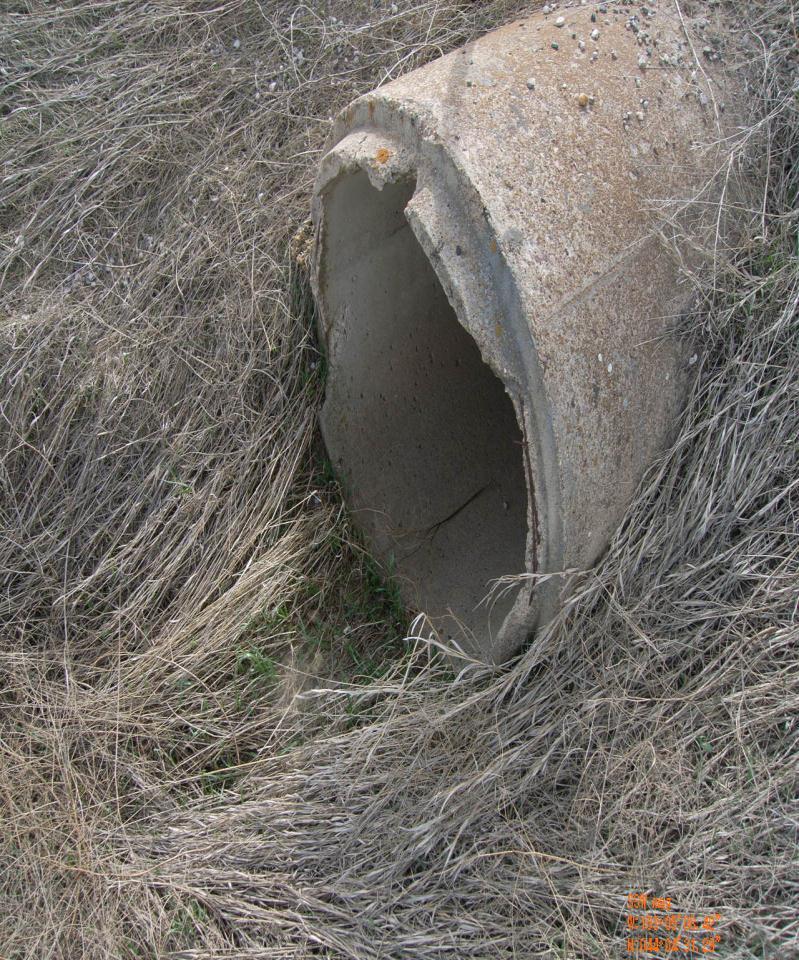
3 About Me: Started at Pennington County Highway Department as a Seasonal Flagger while going to college Graduated from college in 1999 at B.H.S.U. Hired as a Maintenance Worker and Equipment Operator in 2000 Transferred into Traffic Operations in 2005 to current Started using GIS (ArcView 9.0) for the mapping of our traffic signs. Thanks Don! Had no prior GIS experience; learned by trial and error This is my 1 st attempt at a Power Point, so bear with me 3

4 What is this presentation about? 4
5 Why Did We Collect Culvert Data? Asset Management - GASB 34. GASB stands for Governmental Accounting Standards Board. In June 1999, GASB 34 was published. GASB 34 requires state and local governments to begin reporting all financial transactions, including the value of their infrastructure assets, roads, bridges, water and sewer facilities, and dams, in their annual financial reports on an accrual accounting basis. SD Codified Law Inspection of township culverts -- Duty of board of supervisors. The township board of supervisors shall have each culvert on the secondary highways within the township annually inspected and, if necessary, repaired. SD Codified Law Inspection of culverts on secondary highways and county highway system -- Duty of county highway superintendent. The county highway superintendent shall make inspection of all culverts on secondary highways other than those described in and of all culverts on the county highway system and report to the board of county commissioners, which shall cause necessary repairs to be made. 5
6 What Equipment Did We Use To Collect Culvert Data? Garmin etrex 10 - G.P.S. - $96.89 (Amazon.com) Digital Camera $100 or less (we had some) 100 Tape Measure FREE! (Engineering Dept.) Log Book For Recording Culvert Information (printed out recording sheets and placed in binder, so they stay in order and did not get lost) Employees 6


7 GPS MARKING INSTRUCTIONS 1. Turn on GPS by pressing and holding the LIGHT button. 2. Use the TOGGLE button to select the MAP menu or COMPASS menu. 3. Wait for a minute for the GPS to acquire its current location. 4. You will know the GPS has acquired a location on the map screen because the will change to the pointer, or the compass screen will not be empty and fill to a pointer. 5. To mark a sign location you need to press and hold the TOGGLE button on either the MAP or the COMPASS screen, or press the MENU button on the side of the GPS and then use the TOGGLE button to select the MARK WAYPOINT on the menu screen. 6. Write down the Location information on the recording sheet. 7. Use the TOGGLE button to select MAP or DONE after you write down the waypoint information. 8. Press the BACK button on the side of the GPS if you did not want to mark that location. MENU SCREEN COMPASS SCREEN 7

8 Recording Sheets In Binder 8
9 What Computer Software Did We Use To Examine Our Culvert Data? ESRI ArcGIS 10.0 Supplied by City of Rapid City GIS Department Garmin Basecamp FREE! DNR Garmin FREE! ons/dnrgarmin/dnrgarmin.html 9
10 What Data Did We Collect? Culvert Material Culvert Type Inlet/Outlet End Treatment Opening Condition Inlet/Outlet Streambed Material Slope Condition Damage Debris Roadway Settlement 10
11 What Data Did We Collect? (cont.) Shoulder Deteriorating End Separation Skewed To Roadway Signage (Markings) Measurements Diameter, Total Length Of Culvert Inspector Extra Notes (Information that was not on the sheets as choices. We came up with a lot of information we did not have) 11
12 12

13 Collecting Culvert Data Marking a culvert waypoint in the GPS at the road center 13


14 Collecting Culvert Data (cont.) Measuring the roadway length Measuring edge of roadway to the culvert end 14

 Measuring the")
15 Collecting Culvert Data (cont.) Measuring the opening Recording data 15
16 Data Collected; Now What? The employees turn in the collected G.P.S. data and cameras to the office to download every day or every second day of collection (inspected about 50 to 100 culverts a day and inlet/outlet pictures for each culvert). We created Geodatabase Feature Classes with the choices from the data recording sheets; tried to keep the format consistent with the recording sheets. We created folders in our server to organize data that backed up nightly; not good if data is lost. 16
17 Culvert Feature Classes Created 4 separate Geodatabases and templates for each Region/Division (Rapid City Area, Hill City Area, New Underwood Area, and Wall Area) Regions Hill City Division New Underwood Division Rapid City Division Wall Division 17
18 Downloading GPS Waypoint Data Connect the GPS to computer using a USB cable Open Garmin Basecamp software All collected waypoints are displayed in TOC area and on the map 18


19 Select all waypoints Export selection Save waypoints in the native Garmin format which is.gpx Open the DNR Garmin software 19


20 Minnesota DNR Garmin Does not look like much, but it works well 20

 Dbase IV (*.dbf) Text File (*.")
 GPS exchange Format (*.")
21 Load.gpx file saved from Garmin Basecamp Loadable formats are: Arcview Shapefile (*.shp) Dbase IV (*.dbf) Text File (*.txt) Google Earth Format (*.kml) GPS exchange Format (*.gpx) Lowrance Export Text File (*.txt) 21


22 .gpx file loaded into DNR Garmin Finally, we save the file once again as ArcView Shapefile (*.shp) 22

23 Open our Culvert Data map GPS Data Into ArcMap Add Data add our shapefile from our downloaded GPS data 23

24 Create Feature Class from.shp Data Select our layer and open the table Add a Field called WAYPOINT, used for loading data into the template and we have to convert our IDENT field (integer) to a TEXT field 24

25 Use the Field Calculator to get the IDENT field data to the WAYPOINT field Close the table and remove our GPS shapefile from the map Open ArcCatalog and find the templates we made for importing data Copy and paste the Culvert Template file We found this to be the easiest way to import the data multiple times, for multiple feature classes. If you notice we have a bunch of files we imported. 25


26 Rename the pasted file Right-click on the new pasted file, and choose Load Data By choosing Load Data, you can load the *.shp into the feature class template You now have to match the fields with each other so the imported data gets placed in the correct fields 26
27 An inspection sheet that has been filled out with culvert data. If waypoint data was incorrect on G.P.S, we had inspectors also write in the location data as a backup. Most of the information is circled for easy and accurate data collection. 27


28 Culvert Data Entry Entering the data into the feature class Text fields or fields calculated at the end of data entry Most of the data entry is in list box form, so it is very easy to enter in data with very few typing mistakes 28

29 After the data has been entered, the feature is snapped to the County Road Empty fields are calculated with Field Calculator Enter the Hyperlink field into the layer properties, so the pictures of the culverts appear with the culverts for quick reference 29
30 Creating Culvert ID s We collected a lot of culvert waypoints. Then we decided we needed a unique ID for each culvert. This way we can find the specific culvert and track maintenance on them. We decided to use a mileage based ID like we have for our traffic signs. We did not want to measure each one manually. I used the Linear Referencing Tools for that process. By having the culverts snapped to our County Roads layer with each county road having specific ID s, I was able to generate ID s based on our county roads layer and a starting point for the specific road. I create the routes for each region of the county based upon our different regional divisions. I combined all the culverts to one feature class based on the regional divisions. I then ran the Locate Features Along Routes tool in ArcCatalog to generate a mileage for each culvert. 30

31 Routes with symbology showing an arrowhead at end of the route 31

32 Locate Features Along Routes tool 32
 and the Odometer fields to get the Culvert Number, which is the unique ID for the culverts.")
33 Now I have a results table: I calculated the Odometer field by dividing the MEAS field by 5,280, to get miles. I combined the RID (County Road ID) and the Odometer fields to get the Culvert Number, which is the unique ID for the culverts. Then in ArcMap, I joined this table to the culverts using the Way Point field for the area I located, and then did a field calculation for the Culvert Number in the culverts feature class. 33

34 Problems and Challenges!!! The green dots should be culverts marked in the Hill City Area. They are marked in the Box Elder Area. What happened? 34
35 Problems and Challenges!!! (cont.) Employees using a GPS: never used one before, and not wanting to learn how to use one Employees taking pictures standing on top of the culvert ends instead of a distance shot that is useful Not filling out recording sheets completely Writing down incorrect numbers and information; getting one picture number out of order equals a big problem Needing additional choices on recording sheets; we thought we had all the choices listed until people started to inspect them 35
36 Problems and Challenges!!! (cont.) Foremen not explaining how to inventory correctly; crews measured how much culvert was out of the ground instead of entire length Keeping data updated; crews not turning in recording sheets for ongoing maintenance Missing culverts when inspecting, that were not marked with markers Inconsistent results; different people and groups every time out. Fill in project for employees Data getting deleted before it was saved 36

37 Why is there a culvert waypoint marked here? Canyon Lake Dr. is not a County maintained road. 37

38 Do not mark your location in the GPS when you are at lunch at DAIRY QUEEN!! 38
39 Final Results Inventoried 3,238 culverts on Pennington County maintained roads. Foremen in each division can do repairs and maintenance on culverts after doing queries for specific jobs like: Repairing damaged ends from mowers or vehicles Cleaning out plugged culverts for drainage to help prevent roads from flooding on large rain events Knowing the diameter size and length of a culvert to take to a project when replacing an entire culvert Adding or replacing stream bed material to help with erosion Installing end extensions on culverts that are too close to the road edge 39

40 Final Results: Map And Pictures Using A Hyperlink 40


41 Using the hyperlink function in ArcMap to quickly display the culvert pictures 41
42 Looking Into The Future? We started doing maintenance on culverts that have maintenance issues. We tried to use ESRI s ARCGIS Online cloud for maps for other divisions, but it was hard to keep it updated and make good printed maps. The other divisions started using the remote desktop function to view current updated maps. (IT had to setup) We need to create an inspection cycle, 4 divisions, every 4 years? We need to finish with delineation and signage for each culvert. 42
43 Looking Into The Future? (cont.) We have updated our GPS s and cameras, which geo-tag photos. We need to export our data into Highway Department database. IT needs to do programming. Smart phone apps? ESRI has developed apps for the Iphone and Android platforms. 43

44 44
Esri Roads and Highways An Introduction
 Esri International User Conference San Diego, California Technical Workshops July 24, 2012 Esri Roads and Highways An Introduction William Isley Majunu Seran Agenda Product Overview Desktop - Demo: Network
Case Study. ArcGIS Online Launch for. Utilities
 Case Study ArcGIS Online Launch for Utilities We ve published a lot of blog posts on the vision, value proposition and best practices around ArcGIS Online. To showcase the value of embracing these ideas,
Importing Waypoints into Google Earth: Mac
 : Mac Grades 9-12 Overview: Locations stored in a GPS are called waypoints. Waypoints are coordinates that can be transferred from a GPS to a computer. In this activity the waypoint file will be saved
OPEN DATA & PROJECT TRACKER. Michael Chamberlain TPP, Data Management
 OPEN DATA & PROJECT TRACKER Michael Chamberlain TPP, Data Management October 11, 017 Table of contents 1 People 3 Attributes 4 3 Locations 5 4 Systems 6 5 Reports 7-8 6 Applications 8-13 7 Closing 14 Data
user guide phone 2014 by Sysco. All rights reserved.
 user guide phone 2014 by Sysco. All rights reserved. welcome to sysco counts Time is money in the foodservice business and every second counts literally! Sysco Counts simplifies taking inventory and ordering
The Garmin etrex 10/20/30: An Introductory Handbook for Natural Resource Managers
 The Garmin etrex 10/20/30: An Introductory Handbook for Natural Resource Managers Prepared by: GPS: An Introduction and the Basics This handbook is intended to provide you with a basic understanding of
Getting started with BPMe - FAQ
 Getting started with BPMe - FAQ 1 Contents Eligibility 3 Setting up BPMe 4 Payment methods 7 Pay in Car 8 Other Purchases 11 General 12 Security 13 Support for Technical Issues 14 Support 16 2 Eligibility
CONSTRUCTION SOFTWARE
 CONSTRUCTION SOFTWARE Management and Inspection Software Solutions Tailored to Individual Client Needs Government and Fortune 500 Clientele Mobile/Tablets Apple (ipad, iphone), Android, Windows Cloud Data
Drainage Identification, Analysis and Mapping Project
 Drainage Identification, Analysis and Mapping Project Dr. Jay N. Meegoda, PE Professor of Civil & Env. Eng. New Jersey Institute of Tech. Newark, NJ 07102-1982 Drainage Identification, Analysis and Mapping
Mobile for Android User Guide
 Version 1.7 Copyright 2013, 2017, Oracle and/or its affiliates. All rights reserved. This software and related documentation are provided under a license agreement containing restrictions on use and disclosure
FiOS Platform. System functionality:
 FiOS 8 FiOS Platform FiOS product line is the ultimate solution for intelligent GPS tracking and fleet management. Companies from all over the world choose FiOS since it utilizes a powerful set of technologies
Presenter s Name - Presenter s Title DD Month Year. Mobile Solutions IBM Corporation
 Presenter s Name - Presenter s Title DD Month Year Mobile Solutions Maximo Mobile Upgrade Considerations When upgrading to Maximo 7.5, Mobile requires a new install of the latest version of mobile 7.5.1
PREFACE 5 Introduction to InspectTech Software... 5
 1 2 Table of Contents PREFACE 5 Introduction to InspectTech Software... 5 Collector Module 5 Maintenance Module 5 Manager Module 5 Administration Module 5 Mobile Application 5 InspectTech Software s Users...
CommBank Small Business app User Guide
 CommBank Small Business app User Guide CommBank Small Business app user guide 2 Contents Welcome to the CommBank Small Business app 4 CommBank Small Business app in 5 easy steps 4 We re here to help 4
user guide Tablet 2013 by Sysco. All rights reserved
 user guide Tablet 2013 by Sysco. All rights reserved welcome to sysco counts Time is money in the foodservice business and every second counts literally! Sysco Counts simplifies taking inventory and ordering
The ProjectWise Advantage
 2014 Bentley Systems, Incorporated The ProjectWise Advantage October 15, 2013 Eddie Anderson Global Practice Leader - ProjectWise Email Eddie.Anderson@Bentley.com LinkedIn - linkedin.com/in/eddiejanderson
Mobile Marketing. This means you need to change your strategy for marketing to those people, or risk losing them to your competition.
 Mobile Marketing Introduction Mobile marketing is one of the fastest growing segments of online marketing. Over the last two to three years, the number of people who access the internet on mobile devices
Well Pad Design And Heavy Truck Freight Transport. Nick Tonias, P.E.
 Well Pad Design And Heavy Truck Freight Transport Nick Tonias, P.E. The CEDRA Corporation 1985 The CEDRA Corporation is established. 1987 CEDRA begins a long standing relationship with ESRI. 1993 CEDRA
HOW TO: Create a survey in Survey123
 HOW TO: Create a survey in Survey123 The following instructions are a step by step guide to creating an example of an environmental quality survey. Creating the Survey i. Go to https://survey123.arcgis.com/
Contents OVERVIEW... 3
 Contents OVERVIEW... 3 Feature Summary... 3 CONFIGURATION... 4 System Requirements... 4 ConnectWise Manage Configuration... 4 Configuration of a ConnectWise Manage Login... 4 Configuration of GL Accounts...
Data Collection for GIS. April 9, 2015 Frontier Precision User Group
 Data Collection for GIS April 9, 2015 Frontier Precision User Group Goal Overview of the InSphere Platform and our goals to make better data management tools for you Deep dive on a couple of software products
FREQUENTLY ASKED QUESTIONS. Last Revised: September
 Concur Expense Assistant for Expense Questions 1. How do I enable Expense Assistant on my mobile device?... 5 2. How does Expense Assistant work?... 7 3. Do I still have to submit my report to my manager?...
Kronos Timesheet & Workforce Management Guide for Employees
 Kronos Timesheet & Workforce Management Guide for Employees Version 1.0 05/27/2015 Table of Contents I. Introduction..1 II. Getting Started 2 Logging On Changing Your Password Common Icons and Screen Functions
ArcGIS Workflow Manager:
 ArcGIS Workflow Manager: Advanced Topics Kevin Bedel & Nishi Mishra Session Topics Overview Configure & Design Notify & Relate Integrate & Analyze Overview What is ArcGIS Workflow Manager? Configure &
have provided direction in the notes section to view specific items on the slide while reading through the speaker notes. We will reference specific
 Welcome to the BPH Asset Management Program. This is the seventh PowerPoint in the series developed to provide additional information and guidance on developing an asset management plan. The PowerPoints
Great River Energy GIS. John Auel United Services Group
 Great River Energy GIS John Auel United Services Group Background Bachelor of Science at the University of Wisconsin, Steven s Point Area of Emphasis Cartography Currently employed at United Services Group
Asset Management. Visit us at: or call SCAN
 Asset Management Why BarScan? The modern workplace is a complex combination of computer equipment, furniture, and other equipment with compliance, accounting and location tracking issues. To better manage
Presented by Henry L. Barbaro Stormwater Management Unit Supervisor MassDOT Highway Division
 Presented by Henry L. Barbaro Stormwater Management Unit Supervisor MassDOT Highway Division Purpose: Inspection and maintenance are key components of effective stormwater management practice Preparation
AKTIVOV Asset Management System
 AKTIVOV Asset System Aktivov means Assets We provide core expertise, business knowledge, and tools on Enterprise Asset, and Operations & Maintenance Strategies, while you concentrate on your core competence.
We have now introduced a new layout when you first load up the app as can be seen in the image below.
 Dean Taxis New App User Guide After lots of testing and customer feedback sessions, Dean Taxis is pleased to announce its new and improved booking app. This will be getting rolled out over the next week
Course Catalog. Learn.Trimble.com. Rokki Leonard Trimble Field Service Management.
 Course Catalog Learn.Trimble.com Rokki Leonard Trimble Field Service www.trimble.com/fsm Trimble Center Catalog 2 Trimble Center Trimble Center offers many flexible options to suit your training needs.
Complete Guide to Field Service
 Complete Guide to Field Service Salesforce, Winter 18 @salesforcedocs Last updated: November 9, 2017 Copyright 2000 2017 salesforce.com, inc. All rights reserved. Salesforce is a registered trademark of
Winzer Corporation 1 Revision: 4.0
 Table of Content Section 1: Getting Started... 2 1.1 Overview... 2 Section 2: Installation Overview... 3 2.1 Install CD / Start.exe... 3 2.2 Welcome Screen... 4 2.3 Device Selection... 4 2.4 Auto or Industrial...
BMS2 Release Notes. Detailed BMS2 Release Notes. Release Version 5.13 (AMS Release 50)
") BMS2 Release Notes Detailed BMS2 Release Notes Release Version 5.13 (AMS Release 50) 1. Added BMS ID to the email notification detail pop-up in BMS2. 2. Bug requiring a user to delete the DOT AAR number
BMS2 Release Notes Detailed BMS2 Release Notes Release Version 5.13 (AMS Release 50) 1. Added BMS ID to the email notification detail pop-up in BMS2. 2. Bug requiring a user to delete the DOT AAR number
Completing an Internal Audit User Guide For the Reliance Assessment Database
 Completing an Internal Audit User Guide For the Reliance Assessment Database Contents Logging into Reliance... 2 Creating an Audit Plan: Planning Your Internal Audit... 4 Approving an Audit Plan... 20
THE HOME DEPOT. Vendor SSR Training Guide
 THE HOME DEPOT Vendor SSR Training Guide REVISION HISTORY: Application and Program Version Changes Modified By 1.0 Document Created: January 2014 IPR Solutions 2.0 Added information regarding Prebuilt
Roadway Data Extraction Technical Assistance Program (RDETAP) Traffic Safety Conference College Station, June 2016
 Traffic Safety Conference College Station, June 2016") Roadway Data Extraction Technical Assistance Program (RDETAP) Traffic Safety Conference College Station, June 2016 Overview Project motivation and objectives MIRE-MIS Program RDETAP Project Overview of
Roadway Data Extraction Technical Assistance Program (RDETAP) Traffic Safety Conference College Station, June 2016 Overview Project motivation and objectives MIRE-MIS Program RDETAP Project Overview of
Contents OVERVIEW... 3
 Contents OVERVIEW... 3 Feature Summary... 3 CONFIGURATION... 4 System Requirements... 4 ConnectWise Manage Configuration... 4 Configuration of Manage Login... 4 Configuration of GL Accounts... 5 Configuration
PREVIEW. Complete Guide to Field Service. Salesforce, Winter
 Complete Guide to Field Service Salesforce, Winter 18 PREVIEW Note: This release is in preview. Features described in this document don t become generally available until the latest general availability
Managing Your Work with ArcGIS Workflow Manager. Tope Bello
 Managing Your Work with ArcGIS Workflow Manager Tope Bello Objectives of this Workshop Understand the business problems that ArcGIS Workflow Manager solves Present the ArcGIS Workflow Manager framework
Table of Contents. Welcome to igo Figure...1 About this Guide...1 What does igo Figure do?...1 What is Expected of Me?...1
 Table of Contents Overview Welcome to igo Figure...1 About this Guide...1 What does igo Figure do?...1 What is Expected of Me?...1 Chapter 1: The Basics Clocking In and Out...3 In Case of Problems...3
information currently held on our system.
 Some of you may have heard about our new Employee Profile that is now available on your desktop. As Ellucian redesigns all of our portal accesses, self-service Banner and all of the links if offers are
Bar Scan tracks fixed assets in a cost effective manner using the latest handheld technology.
 Asset Management Why BarScan? BarScan tracks fixed assets in a cost effective manner using the latest handheld technology. What is Bar Code Asset Management? A serialized barcode label, RFID tag, existing
REQUEST FOR PROPOSALS
 Announcement REQUEST FOR PROPOSALS ESRI GIS Implementation Services The Madison Metropolitan Sewerage District (MMSD or district ) seeks proposals from qualified vendors to implement Esri s geographic
Your employees must have location services enabled on their device. They are prompted to turn on these services if not already on:
 Time Management Geo-Fencing in Time Management Geo-Fencing provides employees with the freedom to record their activity on their mobile devices while affording you the peace of mind that they are exactly
Property/Fixed Assets Inventory Process
 Property/Fixed Assets Inventory Process 1.0 Use the Master Scan List to determine what schools are due for inventory Begin Process End Process 20.0 Download scanner (see instructions) 2.0 Notify all schools
SellWise Year-End Procedures 2016
 SellWise Year-End Procedures 2016 Background On the last business day of December, print your normal end-of-day reports. These reports can be saved to a folder on your desktop. Because the SellWise system
MobileMapper Pro FAQ: Using Waypoints
 MobileMapper Pro FAQ: Using Waypoints 13 September 2006 How do I create waypoint files in MobileMapper Office for uploading to the receiver? Click on Tools > Place Waypoints or on the Place Waypoints icon
Instruction Manual. for. gskin U-Value Kit
 Instruction Manual for gskin U-Value Kit Status: July 12, 2016 gskin U-Value KIT: Instruction Manual 1 / 10 Content 1. The gskin U-Value KIT delivery overview... 1 2. General overview of the gskin U-value
The Inner Circle Guide to Mobile Customer Service
 The Inner Circle Guide to Mobile Customer Service The rapidly decreasing cost of mobile bandwidth, coupled with the huge improvements in mobile network capabilities means that businesses can be ambitious
Healthcare Demo Scanner 2.0
 Healthcare Demo Scanner 2.0 User Manual Version 1.1, Approved, 30 July 2015 GS1 2015 1 Document Summary Document item Document Title Current value Healthcare Demo Scanner 2.0 User Manual Date Last Modified
Esri Defense Mapping for Server: Defense Product On Demand. Jeremiah Moore G.C. Rice
 Esri Defense Mapping for Server: Defense Product On Demand Jeremiah Moore G.C. Rice Overview Esri Defense Mapping Esri Defense Mapping Produce, Manage, and Share Authoritative Content System of Engagement
Ian Kidner, GISP GIS Systems Administrator Office of Technical Services
 / Ian Kidner, GISP GIS Systems Administrator Office of Technical Services Ian.kidner@dot.ohio.gov 614-752-5743 TIMS Vision Provide Easy & Reliable Access to Information Data Consistency Enables Decision
Asset Management and Data Collection using Digital Video / GPS Data Extraction Techniques
 Asset Management and Data Collection using Digital Video / GPS Data Extraction Techniques TRB 6 th National Conference on Transportation Asset Management Kansas City, Missouri November 2, 2005 Presentation
Mobile Inventory Management
 Mobile Inventory Management 1 Table of Contents Mobile Inventory Management... 2 Overview... 3 Features... 4 Intuitive Design... 5 Functions... 6 Business Applications... 7 2 Mobile Inventory Management
NetSuite OpenAir Mobile for iphone User Guide Version 2.2
 NetSuite OpenAir Mobile for iphone User Guide Version 2 General Notices Attributions NetSuite OpenAir includes functionality provided by HighCharts JS software, which is owned by and licensed through Highsoft
Human Resources (HR) Manager Reports. Generating HR Data Reports at Columbia University. Training Guide
 Manager Reports. Generating HR Data Reports at Columbia University. Training Guide") Human Resources (HR) Manager Reports Generating HR Data Reports at Columbia University Training Guide I NTRODUCTION Introduction The Purpose of this Training Guide The purpose of this training guide is
Human Resources (HR) Manager Reports Generating HR Data Reports at Columbia University Training Guide I NTRODUCTION Introduction The Purpose of this Training Guide The purpose of this training guide is
Banking at the speed of your life. Online. Mobile. Superior. Safe. PARKSTERLING. Answers You Can Bank On.
 Banking at the speed of your life. Online. Mobile. Superior. Safe. PARKSTERLING SM Answers You Can Bank On. At Park Sterling Bank, we know that there are times when our answer can help expand a child s
The benefits of applying Geographical Information Systems (GIS) and. electronic mapping technology to railroad business applications
 and. electronic mapping technology to railroad business applications") The benefits of applying Geographical Information Systems (GIS) and electronic mapping technology to railroad business applications Michael T. Mischke - BNSF Railway, USA ABSTRACT Since its inception in
The benefits of applying Geographical Information Systems (GIS) and electronic mapping technology to railroad business applications Michael T. Mischke - BNSF Railway, USA ABSTRACT Since its inception in
Log into Employee Access. Enter your Login ID and Password Click on Sign In Keep the Login Area set to All Areas
 TrueTime Training 1 The Chrome Box The Chrome Box is attached to the back of a monitor and will have a keyboard and mouse attached to use The Chrome Box will run TrueTime only Each location will have 2
National Performance Research Data Set (NPMRDS): Travel Time Probe Data. Northwestern Indiana Regional Planning Commission
: Travel Time Probe Data. Northwestern Indiana Regional Planning Commission") National Performance Research Data Set (NPMRDS): Travel Time Probe Data Northwestern Indiana Regional Planning Commission Topics Presentation Will Cover: What is the NPMRDS? How is the NPMRDS used? What
National Performance Research Data Set (NPMRDS): Travel Time Probe Data Northwestern Indiana Regional Planning Commission Topics Presentation Will Cover: What is the NPMRDS? How is the NPMRDS used? What
Load Xpert - Load Planning
 Load Xpert - Load Planning User Guide 5990 Auteuil Ave., Brossard, QC, Canada, J4Z 1N2 Tel.: (450) 923-1458 Fax: (450) 923 2077 email: info@loadxpert.com www.loadxpert.com Copyright 2006-2010, CIE-TECH
Year End Close Procedures - 1 -
 Microsoft Dynamics GP 2011 Year-End Closing Procedures This manual should be used as a guide along with the screen specific help, printed Microsoft manuals and on-line help available through CustomerSource,
Volunteer Handbook for GPS Trail Data Collection
 Volunteer Handbook for GPS Trail Data Collection Serving the communities of: Amesbury Andover Boxford Georgetown Groveland Haverhill Lawrence West Newbury Merrimac Methuen Newbury Newburyport North Andover
Office Safety Auditing
 Office Safety Auditing Story What am I trying to accomplish with this app Provide an easy to use application to conduct Office Safety Audits for large office facilities Context Charles is the Environmental,
Supervisor Web Services Training Guide For. Aquinas College
 Supervisor Web Services Training Guide For Aquinas College This is an overview of all the employees assigned to the supervisor that is currently logged in. This screen is also a quick reference to check
What is Castleton Agile?
 Agile Datasheet About us Castleton is the only truly integrated IT housing solutions provider in the industry. We deliver an unrivalled portfolio of market leading, cutting edge software and infrastructure
EXHIBIT A SCOPE OF SERVICES Districtwide Storm Sewer Inspection
 EXHIBIT A SCOPE OF SERVICES Districtwide Storm Sewer Inspection 1.0 Objective: The Department desires to obtain services from the Vendor to inspect existing storm sewer systems. This includes the remote
Justification to Carryover Prior Fiscal Year POs User Guide
 Justification to Carryover Prior Fiscal Year POs User Guide Overview: Once a Purchase Order (PO) has been carried over to the next fiscal year, it requires a justification to keep it open and again carry
Measures for Highway Maintenance Quality Assurance
 Measures for Highway Maintenance Quality Assurance Teresa M. Adams Professor, Civil and Environmental Engineering Director, Midwest Regional University Transportation Center Janille Smith Graduate Research
Cass County Soil Erosion & Sedimentation Control Program
 Cass County Soil Erosion & Sedimentation Control Program Both residents and visitors of Cass County enjoy the beauty of over 250 lakes and ponds, along with numerous streams, creeks, and wetlands that
ASSET MANAGEMENT GUIDE
 ASSET MANAGEMENT GUIDE For Local Agencies in Indiana JUNE 2017 This Guide was developed for the Indiana LTAP by Applied Pavement Technology, Inc. 115 West Main Street Suite 400 Urbana, Illinois 61801 (217)
Managing Gas Facility Inspections with Workforce for ArcGIS. Esri GeoConX 2017
 Managing Gas Facility Inspections with Workforce for ArcGIS Esri GeoConX 2017 Peoples Gas Founded in 1850 Deliver natural gas to about 843,000 customers in the city of Chicago. ~20 GIS staff supporting
GPS Fleet Software. For German Customers: Software-Management GmbH
 GPS Fleet Software Better control of your fleet safes valuable time and your money Automatic electronic logbook instead of manual notes Easier daily scheduling Getting real-time alerts via SMS, Email or
Welcome! Thank you for your interest in upgrading your service with Great Lakes Energy Cooperative (GLE).
.") Welcome! Thank you for your interest in upgrading your service with Great Lakes Energy Cooperative (GLE). Enclosed is the information needed to upgrade your service with GLE. Please read the documents
Welcome! Thank you for your interest in upgrading your service with Great Lakes Energy Cooperative (GLE). Enclosed is the information needed to upgrade your service with GLE. Please read the documents
ArcGIS Extensions: Tools for Improving Data and Map Production. Sherry Fagin & Amber Bethell
 ArcGIS Extensions: Tools for Improving Data and Map Production Sherry Fagin & Amber Bethell Production Assembly Line Production Produce a flashy sports car Without Standards Production Produce a flashy
CONVERSION GUIDE Trial Balance CS and Engagement CS to AdvanceFlow
 CONVERSION GUIDE Trial Balance CS and Engagement CS to AdvanceFlow Introduction and conversion overview... 1 Conversion considerations and recommendations... 2 Installing the conversion program... 3 Import
Z Z. Motivate Your. How To. Field Workforce By Using Mobile Apps
 How To Motivate Your Field Workforce By Using Mobile Apps Z Z Z Wake Them Up! If your field engineers are under the weather and need some motivation to be more efficient, then you can wake them up with
JD Edwards EnterpriseOne Mobile Applications
 JD Edwards EnterpriseOne Mobile Applications Mobile computing is fast becoming the business norm. Professionals need the flexibility to rapidly execute time-critical tasks from any location. To keep pace
MOVE YOUR BUSINESS FORWARD.
 MOVE YOUR BUSINESS FORWARD. Move to QuickBooks Online. David Williams Hooker s Sweet Treats Selby Tax and Accounting #1 QuickBooks Online is the cloud accounting solution for small businesses. 1 Get on
Sage What s New. December 2017
 Sage 100 2018 What s New December 2017 2017 The Sage Group plc or its licensors. All rights reserved. Sage, Sage logos, and Sage product and service names mentioned herein are the trademarks of The Sage
Table Of Contents. Pg. 13. EXAMPLES OF SHARING CONTENT AND HOW THEY LOOK ON OTHER SOCIAL NETWORKS.
 1 P a g e Table Of Contents Pg 1.-Pg 4. - T.O.C. Pg 5. INTRO PAGE. Pg 6. STEP 1 -REGISTRATION. Pg 7. STEP 2 - HOW TO CONNECT SOCIAL MEDIA ACCOUNTS TO YOUR ONG.SOCIAL DASHBOARD. Pg 8. STEP 3 - HOW TO VIEW
Apps for Agriculture Download this page:
 Apps for Agriculture Download this page: http://www.ag.ndsu.edu/agmachinery Crop Production NDSU Pest Management The Pest management app is a tool that combines select information from the North Dakota
MINNESOTA ARCHITECTURE - HISTORY INVENTORY FORM
 Identification Historic Name Bridge 5388 Current Name Bridge R0529 Field # Address State Highway 2 over the Little Iowa River City/Twp LeRoy Township County Mower Legal Desc. Twp 101N Range 14W Sec 21
Emerging Patterns for Implementing the ArcGIS Platform. Marten Hogeweg Peter Bottenberg
 Emerging Patterns for Implementing the ArcGIS Platform Marten Hogeweg Peter Bottenberg Deploying the Platform is About It s About the Organization Enabling All of the Users in the Organization Bringing
SECTION TRENCHING & BACKFILLING
 SECTION 02225 - TRENCHING & BACKFILLING 1.0 GENERAL 1.1 Work included in this Section includes trenching and backfilling for underground pipelines and related structures only. 1.2 Reference Specifications
Please refer to the Summary of Findings section of the attached inspection report and provide a written response for each violation that was noted.
 January 13, 2014 Mr. Joe Stewart, General Manager Valley View Golf Course, L.L.C. Washington County Property Improvements District #5 11520 Clubhouse Parkway Farmington, Arkansas 72730 RE: Reconnaissance
TEMPLE UNIVERSITY CEMS Chemical Environmental Management System
 TEMPLE UNIVERSITY CEMS Chemical Environmental Management System CEMS OVERVIEW What CEMS is: CEMS is the online chemical inventory system for Temple University and Temple University Health System. All chemical
Infor10 EAM v10.1: What's New?
 Infor10 EAM v10.1: What's New? Introduction Kevin Price, Sr. Product Manager Kevin is a more than 14-year veteran of the asset management business at Infor, serving roles in sales, service, product management,
Using Technology to Enhance Mitigation Capability 2014 ASFPM Annual Conference
 Using Technology to Enhance Mitigation Capability 2014 ASFPM Annual Conference June 3, 2014 Today's Speakers Rob Flaner Hazard Mitigation Program Manager, Tetra Tech, Inc. Over 25 Years experience in floodplain
Identify challenges IFTA presents to carriers and the impact it has on carriers.
 White Paper Understanding IFTA Get Smart about IFTA The International Fuel Tax Agreement Executive Summary: Interstate motor carriers have to deal with a wide array of government regulations that demand
A GIS Database for Warehouse Operations. A Project for Geography 575 Anderson Folts and Melelani Sax-Barnett
 A GIS Database for Warehouse Operations A Project for Geography 575 Anderson Folts and Melelani Sax-Barnett Outline Background Design objectives Data Applications Product distribution Routing Limitations
myvrs Navigator Frequently Asked Questions
 myvrs Navigator Frequently Asked Questions Table of Contents 1. Setting Up Your Account 2. Security 3. Employer Roles and Managing Contacts 4. Enrolling New Employees 5. Updating Existing Employees 6.
Using Enterprise etime
 Using Enterprise etime Handout Manual Appendix Automatic Data Processing, Inc. Roseland V11090972216ET61 2009 ADP, Inc. Appendix Using Hyperfind Queries with QuickNavs When your ADP representative sets
Consignee Guide. Version 1.8
 Consignee Guide Version 1.8 TABLE OF CONTENTS 1 Welcome to FlashConsign.com...6 2 Your Consignee Account...7 2.1 Creating a Consignee Account...7 3 Creating a Consignment Sale...10 3.1.1 Consignment Sale
Updating LANDFIRE Fuels Data For Recent Wildfires
 Updating LANDFIRE Fuels Data For Recent Wildfires Anthony J. Beauchaine Boise National Forest, USDA Forest Service Kori Blankenship The Nature Conservancy, LANDFIRE Don Helmbrecht USDA Forest Service,
Expense Management for Microsoft Dynamics NAV
 Expense Management for Microsoft Dynamics NAV Setup Quick Guide version 2.60 Page 1 of 33 Table of contents Introduction... 2 About the Setup Quick Guide for Continia Expense Management... 3 Bank integration...
DATABASICS Time User s Guide v3.1
 DATABASICS Time User s Guide v3.1 A Guide to CALIBRE s Time Reporting Website July 2016 CALIBRE 6354 Walker Lane, Suite 300 Alexandria VA 22310 1 Table of Contents Before You Get Started... 3 Accessing
User s Manual. esims Web. Synthes Information Management Suite.
 User s Manual esims Web. Synthes Information Management Suite. Table of Contents Navigation and Interface Structure of the User Interface 1 Getting Around 2 Search and Edit Search 3 Cycle Count Recording
Sage Peachtree Product Overview. New! Sage Peachtree 2012
 Sage Peachtree 2009 2012 Product Overview New! Sage Peachtree 2012 Sage Peachtree is the accurate, easy-to-use accounting software that provides the insights and control you need. With the Sage Peachtree