P310 VTOL UAV CHC P310 VTOL UAV. Zhen Yann Zhen Yann - UAV Product Manager UAV Product Manager Shanghai, 15 February,2017 Shanghai - Feburary 15, 2017
|
|
|
- Alvin Goodman
- 6 years ago
- Views:
Transcription


1 P310 VTOL UAV CHC P310 VTOL UAV Zhen Yann Zhen Yann - UAV Product Manager UAV Product Manager Shanghai, 15 February,2017 Shanghai - Feburary 15, 2017
2 1 CHC Profile 2 CHC VTOL UAV Introduction 3 4 CHC VTOL UAV Aerial Mapping Solution CHC VTOL UAV Application Case
3 CHC is the leading provider of UAV aerial surveillance, aerial mapping solution in China CHC is a professional and leading brand of flight control and navigation technology for fixed-wing UAVs and Multi-rotor UAV applications since 2010 (CHC established in 2003.) CHC series VTOL fixed wing UAVs are hybrids between fixed wing airplanes and multi-copters, able to take off and land vertically like Multi-copters and transition to efficient and fast forward flight like a fixed wing UAV, this is the ideal choice for professional industrial applications. Customer' sneeds are our focus. All CHC series products are characterized by seamless usability, compact modularity and robust functionality CHC CEO George Zhao established UAV Department Successful CHC UAV team quad-rotor UAV Succesful completaion of CHC UAV Flight control system and P560 Six-rotor UAV platform P310 VTOL Fixed Wing UAV developed successfully, more than 200 units sold in 2016
-Rotor")
4 P310 VTOL Fixed Wing UAV P560 Six(or Eight)-Rotor Wing UAV
5 1 CHC Profile 2 CHC VTOL UAV Introduction 3 4 CHC VTOL UAV Aerial mapping Solution CHC VTOL UAV Application Case

6 Fixed Wing UAV Advantages & Disadvantages Advantages: Long flight endurance; High speed Disadvantages: Difficult takeoff and landing; runway and complicated launch system required, low success for net recoverys and low accuracy of parachute landings.
 High payload Disadvantage: Short flight endurance Low")
7 Multi-copter UAV Advantages & Disadvantages Advantages: VTOL(Vertical Take off and Landing) High payload Disadvantage: Short flight endurance Low speed
 High Payload Disadvantages: Short flight endurance Low speed Complicated Operation")
8 Unmanned Helicopter Advantages & Disadvantags Advantages: VTOL (Vertical Takeoff and Landings) High Payload Disadvantages: Short flight endurance Low speed Complicated Operation High Cost


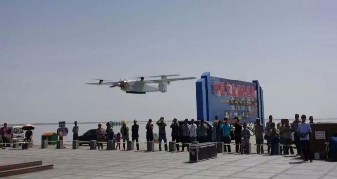
9 The P310 combines the advantages of Rotor and Fixed Wing UAVs Long Endurance High Speed Long Range CHC UAV Hybrid Vertical takeoff &Landing

10 P310 Series VTOL Fixed Wing UAV Multi-Application: aerial photography, powerline/pipeline inspection, disaster prevention, geological survey and emergency response. Hybrid configuration design for fixed wing and multi - rotors UAV. Fully autonomous VTOL, no runway or launch system required. RTK DGPS for high accuracy positioning. Integration of professional flight control and navigation systems, mission software and GCS.
11 P310 Series VTOL Fixed Wing UAV Composite Wings layout Intelligent & Convenient Flight Control Software Easy to Setup (8 mins) and Transport Dual-differential Module (GPS and PPK) Low Cost ( No need Launch and Recovery Equipment ) Optional: Pix4D Mapper- professional post processing software Context Capture: Advanced 3D Modelling Software

12 P310 Series VTOL Fixed Wing UAV Wingspan 2.6 m Takeoff and Landing VTOL Max. Ceiling 4500 m Fuselage Length 1.6 m Endurance 90 min Data Link Range >30 km MTOW 12 kg Max Speed 108 Km/h Power Battery Playload 1~2 kg Cruise Speed 72 Km/h Package Size 1500 x 500 x 500 mm

13 Assembling the P310 Unit Shanghai CHC UAV TECH Tail Wing Main Wing Parts 1, 2 Hover Rotor 2 Fuselage Power Compartment Cover Payload Compartment Cover Fixed Wing Power Pack Batteries: 10k & 30k mah UHF Radio Antenna
")

14 Payload Standard(Maximum payload 2kg) Sony α7 42 million pixel full frame camera Shanghai CHC UAV TECH Optional(Maximum payload 2kg) Electro-optical Pod(Obtain video images of Visible and thermal imager) Dual tilt photograph Camera(Obtain tilt and ortho photos for building 3D model)

15 Creating P310 Flight Routes(a) Shanghai CHC UAV TECH 1. Import the area to survey 2. Configure the Camera and Photo setting

16 Creating P310 Flight Routes (b) Shanghai CHC UAV TECH 3. Flight route adjustment 4. Flight route generation


17 P310 VTOL UAV Work Flow Shanghai CHC UAV TECH 1.Create 2.Pre-flight 3.Command 4.Vertical Flight Plan Check Takeoff Takeoff 5.Transit to 6. Flight 7.Command 8.Transit to Fixed Wing Mission Landing multi-rotors 9.Vertical 10. POS Data 11. RTK POS 12. POS Data 13. Image Landing Download DataDownload Analysis Analysis
18 1 CHC Profile 2 CHC VTOL UAV Introduction 3 4 CHC VTOL UAV Aerial mapping Solution CHC VTOL UAV Application Case
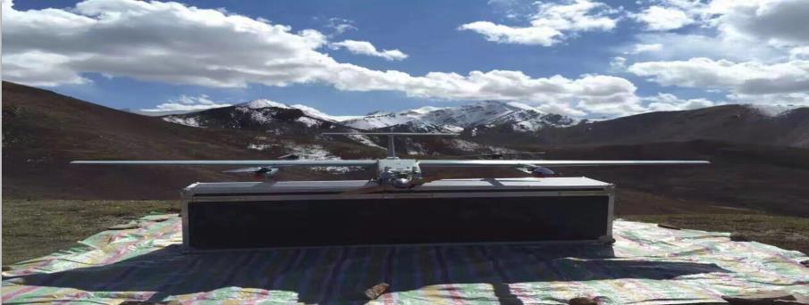
19 1:1,000 Scale Topographic Map Project in Rong City China High UAV Training Cost: Operators need extensive time for UAV training Serious Fog Haze: Fog haze leads to low visibility which is bad for flighting 02 High Data Accuracy: A tradional e n gineering survey is hard to achieve at 1:1000 map scale 01 03

 flight duration. 2.")

20 1:1,000 Scale Topographic Map Project in Rong City China 1. The P310 was selected because of it's long (1.5 hour) flight duration. 2. CHC's great hardware and software technical support. 3. VTOL (Saves take off and landing space.) 4. Easy to deliver, setup and deploy.
21 Advantages of the P310 VTOL UAV for Aerial Mapping Traditional UAV Aerial Mapping Shanghai CHC UAV TECH VTOL UAV Aerial Mapping Requires runway or heavy launch system for takeoff /landing Hybrid design for vertical takeoff and landing High cost for pilot training Fully autonomous controlled by GCS, low cost for GCS software training High cost for dense ground control points POS data and low precision of POS data Post processing DGPS module improve the precision of POS data and decrease the quantity of ground control point POS data Low reliability and stability Military quality ensures highest reliability
22 1:500 Ortho Photo Land-Ownership in GuangXi Province, China Complx terrain: Can not find more than 100 square meter site for take off / landing. More rainy days: Narrow flight path spacing required because of rainy season.conventional processing software has difficulties handling the low accuracy data. Hard to set control points: Complex terrain make it difficult to reach positions of control points for survey.


23 1:500 Ortho Photo Land-Ownership in GuangXi Province, China Why they select P310? 1. VTOL allows small take-off area. 2. Powerful Pix4D (Smart mosaic Stitching) 3. PPK module reduces control points by 80% 4. Stable flight in high cross winds.
24 Typical problem solution Shanghai CHC UAV TECH Personal VTOL Intelligent planning; Auto-flight planning; Professional training Control points Internal PPK Mode 80% control point reduction Fewer than 5 control points for 1:2000 scale mapping Weather Pix4d uses image recognition technology to solve poor image data quality caused by varing overlap spacing and frequent wind gusts Efficiency 8 mins assembly; 42 million pixel full frame camera; Easy to install and transport Accuracy Dual-differential Module; Powerful pod which can carry Electro-optical Pod and Dual tilt photograph Camera VTOL Very small take-off and landing sites; important for complex environments (Mountains, hills, jungles)


25 P310 Post Processing Software Pix4d Mapper Pro Auto-aerial triangulation Point cloud encryption, Regional adjustments, Camera calibration

 DEM")
 DLG (digital")
26 P310 Post processing software Pix4d Mapper Pro DOM (digital orthophoto map) DEM (digital elevation map) DLG (digital line graph)

27 P310 Post Processing Software Context Capture 3D realistic modeling
28 1 CHC Profile 2 CHC VTOL UAV Introduction 3 4 CHC VTOL UAV Aerial mapping Solution CHC VTOL UAV Application Case


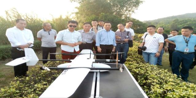
29 P310 UAV Chinese Police Department Application

30 P310 UAV Ecuadorian Police Department Application


31 P310 UAV Civil Sector Applications
32
Advanced Tactics Announces the Release of the AT Panther Drone First Aerial Package Delivery Test with a Safe Drive-up-to-your-doorstep Video
 UPDATED 03APRIL2017 MEDIA CONTACT: press@advancedtacticsinc.com (310) 325-0742 Advanced Tactics Announces the Release of the AT Panther Drone First Aerial Package Delivery Test with a Safe Drive-up-to-your-doorstep
Terms of Reference. Purchase of aerial surveillance service for the EU external land borders
 Annex II Terms of Reference Purchase of aerial surveillance service for the EU external land borders Ref. No: Frontex/ Purchase of aerial border surveillance service aircraft equipped with multi-intelligence
BHE UAV Family Unmanned Aerial Vehicle System
 BHE UAV Family Unmanned Aerial Vehicle System UAV Development at BHE Bonn Hungary Electronics Ltd. BHE Bonn Hungary Electronics Ltd. Address: Fóti str. 56. Budapest, H-1047 Hungary Phone: (1) 233-2138,
Performing UAV Mission Planning, Design, & Optimization
 Performing UAV Mission Planning, Design, & Optimization Russ Magazzu UAV Product Manager Pg 1 of 30 Agenda Unmanned aerial systems application areas capabilities STK 8 Aircraft Mission Modeler Pg 2 of
LOW COST AERIAL MAPPING WITH CONSUMER-GRADE DRONES
 LOW COST AERIAL MAPPING WITH CONSUMER-GRADE DRONES S.L. Madawalagama 1, N. Munasinghe 2, S.D.P.J.Dampegama 3, L. Samarakoon 1 1 Geoinformatics Centre (GIC), Asian Institute of Technology (AIT), PO Box
Vision VTOL. The Future of Flight
 Vision VTOL The Future of Flight What if batteries had just 10 times their current power density? What would an aircraft look like? What could it do? Wings become obsolete. Motors become as reliable as
monitoring it i volcanic gas sampling and analysis
 Volcan, an autonomous volcanic gas sampling Unmanned Aerial Vehicle outbreak of a crisis: identification of causes and effects,, rescue coordination,, first aid volcanic area surveillance and monitoring
CONCEPTUAL DESIGN OF A VTOL REMOTELY PILOTED AIRCRAFT FOR EMERGENCY MISSIONS
 SCIENTIFIC RESEARCH AND EDUCATION IN THE AIR FORCE-AFASES 2016 CONCEPTUAL DESIGN OF A VTOL REMOTELY PILOTED AIRCRAFT FOR EMERGENCY MISSIONS Razvan UDROIU, Madalina Ioana BLAJ Transilvania University of
Flying high: India s indigenous UAV programmes
 Flying high: India s indigenous UAV programmes [Content preview Subscribe to Jane s International Defence Review for full article] India has been developing unmanned aerial vehicles for almost a decade,
A CONTRAST AMONG EXPERIMENTS IN THREE LOW-ALTITUDE UNMANNED AERIAL VEHICLES PHOTOGRAPHY: SECURITY, QUALITY & EFFICIENCY
 A CONTRAST AMONG EXPERIMENTS IN THREE LOW-ALTITUDE UNMANNED AERIAL VEHICLES PHOTOGRAPHY: SECURITY, QUALITY & EFFICIENCY WU Yundong a, b, c, *, ZHANG Qiang b, LIU Shaoqin d a College of Sciences, Jimei
Drone Surveying: The Complete Story
 Drone Surveying: The Complete Story NYSAPLS Friday Webinar Series December 1, 2017 Aerotas enables surveyors to map by drone More than: 60 clients, 600 drone surveys, 450 hours of field testing & training,
Mapping on a Budget. Using Drones & Digital Data. Jeff Campbell
 Mapping on a Budget Using Drones & Digital Data Jeff Campbell 1 Mapping with Minimal Investment UAS Mapping suited to Incremental Approach Large Up front investment not necessary. Determine if you have
A Review on Vertical Take Off and Landing (VTOL) Vehicles
 Vehicles") A Review on Vertical Take Off and Landing (VTOL) Vehicles Aditya Intwala PG Student Department of Mechanical Engineering Symbiosis Institute of Technology, Pune, India Yash Parikh Assistant Professor Department
A Review on Vertical Take Off and Landing (VTOL) Vehicles Aditya Intwala PG Student Department of Mechanical Engineering Symbiosis Institute of Technology, Pune, India Yash Parikh Assistant Professor Department
Technical Layout of Harbin Engineering University UAV for the International Aerial Robotics Competition
 Technical Layout of Harbin Engineering University UAV for the International Aerial Robotics Competition Feng Guo No.1 Harbin Engineering University, China Peiji Wang No.2 Yuan Yin No.3 Xiaoyan Zheng No.4
UAV-MAPPING A USER REPORT
 UAV-MAPPING A USER REPORT W. Mayr GERMATICS GmbH, Oskar-Frech-Str. 15, D-73614 Schorndorf (werner.mayr@germatics.com) Commission I, WG I/V KEY WORDS: UAVs, Photogrammetry, Regulations, Sensor Orientation,
Drones and Their Role in Agriculture. Mike Buschermohle Precision Ag Specialist UT Extension
 Drones and Their Role in Agriculture Mike Buschermohle Precision Ag Specialist UT Extension Current FAA Regulatory Environment Public UASs can fly under a Certificate of Authorization (COA). Government
Drone Enterprise Solutions
 Minneapolis - Chicago - Denver - Calgary - Washington, D.C. DaaS Drone-as-a-Service Drone Enterprise Solutions Flying IoT Devices Dynamic Digital Intelligence Drone Technology Drone Enterprise Solutions
Unmanned Aerial Vehicle (UAV)-Based Remote Sensing for Crop Phenotyping
-Based Remote Sensing for Crop Phenotyping") Unmanned Aerial Vehicle (UAV)-Based Remote Sensing for Crop Phenotyping Sanaz Shafian 1, Nithya Rajan 1, Yeyin Shi 2, John Valasek 3 & Jeff Olsenholler 4 1 Dept. of Soil and Crop Sciences; 2 Dept. of Biological
Unmanned Aerial Vehicle (UAV)-Based Remote Sensing for Crop Phenotyping Sanaz Shafian 1, Nithya Rajan 1, Yeyin Shi 2, John Valasek 3 & Jeff Olsenholler 4 1 Dept. of Soil and Crop Sciences; 2 Dept. of Biological
Collaboration Between Unmanned Aerial and Ground Vehicles. Dr. Daisy Tang
 Collaboration Between Unmanned Aerial and Ground Vehicles Dr. Daisy Tang Key Components Autonomous control of individual agent Collaborative system Mission planning Task allocation Communication Data fusion
BCN Drone Center Datasheet
 BCN Drone Center Datasheet Segregated Airspace (TSA-31 CTC-Moià) Airfield Operation Area Area Maximum Altitude Minimum Altitude LOS Operation BVLOS Operation Area Main Runway Secondary Runway Helipad 25
UNMANNED SURFACE VESSEL (USV)
") UNMANNED SURFACE VESSEL (USV) UNMANNED SURFACE VESSEL (USV) By using Arma-Tech Tactical Autonomous Control Kit (ATTACK), the vessel can operate independently or combined in swarm. Completely autonomously
UNMANNED SURFACE VESSEL (USV) UNMANNED SURFACE VESSEL (USV) By using Arma-Tech Tactical Autonomous Control Kit (ATTACK), the vessel can operate independently or combined in swarm. Completely autonomously
AEM 5495 Spring Design, Build, Model, Simulate, Test and Fly Small Uninhabited Aerial Vehicles (UAVs)
") AEM 5495 Spring 2011 Design, Build, Model, Simulate, Test and Fly Small Uninhabited Aerial Vehicles (UAVs) Gary J. Balas balas@umn.edu Monday-Wednesday 3:35-4:50 PM 211 Akerman Hall UAV Course Syllabus
AEM 5495 Spring 2011 Design, Build, Model, Simulate, Test and Fly Small Uninhabited Aerial Vehicles (UAVs) Gary J. Balas balas@umn.edu Monday-Wednesday 3:35-4:50 PM 211 Akerman Hall UAV Course Syllabus
Air Reconnaissance to Ground Intelligent Navigation System
 Air Reconnaissance to Ground Intelligent Navigation System GROUP MEMBERS Hamza Nawaz, EE Jerrod Rout, EE William Isidort, EE Nate Jackson, EE MOTIVATION With the advent and subsequent popularity growth
DRONE-OLOGY - TO INFINTY AND BEYOND! ADSK Solutions. Chad Studer Owner/President
 ADSK Solutions Chad Studer Owner/President ADSK SOLUTIONS SALES - RENTALS CONSULTING - TRAINING - SUPPORT AUTODESK 3D SCANNERS UAV aka DRONES BLUEBEAM Supported Application POINT CLOUDS LIDAR/UAV MOBILE
AeroVironment, Inc. Unmanned Aircraft Systems Overview. Background
 AeroVironment, Inc. Unmanned Aircraft Systems Overview Background AeroVironment ( AV ) is a technology company with a 40-year history of practical innovation in the fields of unmanned aircraft systems
Annex 1: Resources to be committed to the 2nd RAWFIE Open Call
 Annex 1: Resources to be committed to the 2nd RAWFIE Open Call The following tables describe the resources, which will be made available to the 2 nd Open Call by each testbed. Table 1: Testbeds to be made
Dept. of Electrical Engineering. UAV Sensing and Control. Lang Hong, Ph.D. Wright State University
 Senior Design Projects: UAV Sensing and Control Lang Hong, Ph.D. Dept. of Electrical Engineering Wright State University Topic List Light-Weight/Accurate Altimeter for a Small UAV Gyro-Stabilized Servo-Driven
LF Track III: Drone Technology Application in Waste Management Facility. Presented by Mike Cobb
 LF Track III: Drone Technology Application in Waste Management Facility Presented by Mike Cobb Authors Osvaldo Lucero Maria Eugenia Rey Nores Ezequiel Verdini James Law Benito Roggio Ambiental, Argentina
CIEEM Autumn Conference Workshop
 CIEEM Autumn Conference Workshop Getting to grips with the use of Small Unmanned Aerial Vehicles (SUAVs) in Ecological Practice Nottingham 2016 Cameron S Crook MCIEEM Cameron S Crook & Associates Introduction
UNMANNED AERIAL VEHICLE SYSTEMS
 UNMANNED AERIAL VEHICLE SYSTEMS UNMANNED AERIAL VEHICLE SYSTEMS INTRODUCTION UAV SYSTEMS APPLICATIONS LEGISLATION SAFETY CONSIDERATIONS HOW TO SELECT A COMPETENT SUPPLIER OF UAV SERVICES Q&A One of Europe's
VT Group Unmanned Systems Capabilities Brief.
 VT Group Unmanned Systems Capabilities Brief Our Company Our success rests in its three lines of business Integrated Solutions, Technical Services and Unmanned Systems. From providing turnkey engineering
$ / maximum area Imagery $10-20 No limit $<1-3. $ / minimum area
 Technical Note Forest Industry Applications of UAVs 20 July 2017 Authors: Dr Grant Pearse *, Dr Michael Watt. * Corresponding author: grant.pearse@scionresearch.com Summary A recent project at Scion explored
Advantages of Using Laser Scan and UAV Technology in Virtual Asset Management
 Advantages of Using Laser Scan and UAV Technology in Virtual Asset Management Authors: Paul David Ramirez and George Mann Unmanned Ad-Hoc Industries, Inc. 519 E Oak Hill Dr, Spring, Texas 77386 www.globaluai.com
Co-operating Miniature UAVs for Surveillance and Reconnaissance
 Co-operating Miniature UAVs for Surveillance and Reconnaissance Axel Bürkle 1, Sandro Leuchter 1 1 Fraunhofer Institute for Information and Data Processing IITB Fraunhoferstraße 1, 76131 Karlsruhe Abstract.
HurleyIR Drone Kits HurleyIR is a DJI Authorized Dealer
 The HurleyIR UAS Aerial System is a fully customizable surveillance platform. Cutting edge fail safe technology and intelligent flight modes make flying easy and comfortable for any operator. The included
DroneDeploy. DroneDeploy's 2017 Drone Buyer s Guide. The Ultimate Guide to Choosing a Mapping Drone for Your Business
 DroneDeploy DroneDeploy's 2017 Drone Buyer s Guide The Ultimate Guide to Choosing a Mapping Drone for Your Business Table of Contents 01 Preparing for Takeoff Introduction... 3 02 Getting Started What
Drones for Commercial Last-Mile Deliveries: A Discussion of Logistical, Environmental, and Economic Trade-Offs
 Portland State University PDXScholar Civil and Environmental Engineering Faculty Publications and Presentations Civil and Environmental Engineering 9-15-2017 Drones for Commercial Last-Mile Deliveries:
14+ FOR AGES 14 AND UP ITEM NO
 14+ FOR AGES 14 AND UP ITEM NO. 33743 INTRODUCTION Thank you for purchasing this amazing World Tech Toys product. This drone is suitable for indoor and outdoor flight. Please carefully read the entire
Design and control of an unmanned aerial vehicle for autonomous parcel delivery with transition from vertical take-off to forward flight -
 Design and control of an unmanned aerial vehicle for autonomous parcel delivery with transition from vertical take-off to forward flight - VertiKUL, a quadcopter tailsitter Menno Hochstenbach, Cyriel Notteboom
UAVs 4 STEM. Using recreational drones for learning. March 22, 2016 Presenters: LuAnn Dahlman, NOAA Dan Zalles, SRI
 UAVs 4 STEM Using recreational drones for learning E Federation of Earth Science Information Partners (ESIP) adsf Education Committee March 22, 2016 Presenters: LuAnn Dahlman, NOAA Dan Zalles, SRI Earth
Electronic Warfare Capabilities of Mini UAVs
 Electronic Warfare Capabilities of Mini UAVs Abstract David Ledger 1 Mini UAVs are at the leading edge of robotic systems being introduced into the Electronic Warfare environment. The Aerosonde Robotic
Different tools for different tasks: RPAs and seal surveys. Sea Mammal Research Unit, University of St Andrews
 Different tools for different tasks: RPAs and seal surveys Patrick Pomeroy Luke O Connor Sea Mammal Research Unit, University of St Andrews UK Seal popula;ons (i) greys UK has 40% of world s grey seals
Project Readiness Package Rev 7/22/11
 INTRODUCTION: ADMINISTRATIVE INFORMATION: Project Name (tentative): Quadcopter Navigation System Project Number, if known: R14902 Preferred Start/End Semester in Senior Design: Fall/Spring Spring/Fall
A Study on Generation of 3D Model and Mesh Image of Excavation Work using UAV
 A Study on Generation of 3D Model and Mesh Image of Excavation Work using UAV D.H. Kim a, S.W. Kwon b, S.W. Jung c, S. Park d, J.W. Park e and J.W. Seo f a Department of Convergence Engineering for Future
Quadcopter Video Surveillance UAV
 By Anton Nakazawa Bai Xiang Jin anak@uvic.ca barryjin@uvic.ca URL: http://web.uvic.ca/~barryjin/ Supervisor: Michael Adams Group: 7 Dept. Electrical and Computer Engineering University of Victoria All
Multikopter - Solutions MikroKopter
 English Multikopter - Solutions MikroKopter HiSystems.de Product Overview Professional drones & flying robots Location Germany strengthen the region HiSystems - High Tech from Lower Saxony HiSystems has
Autonomous Patrol and Surveillance System (APSS) A Student Project to Help Aid the Campus Police
 A Student Project to Help Aid the Campus Police") Paper ID #6059 Autonomous Patrol and Surveillance System (APSS) A Student Project to Help Aid the Campus Police Dr. Adeel Khalid, Southern Polytechnic State University (ENG) Dr. Adeel Khalid is an assistant
Paper ID #6059 Autonomous Patrol and Surveillance System (APSS) A Student Project to Help Aid the Campus Police Dr. Adeel Khalid, Southern Polytechnic State University (ENG) Dr. Adeel Khalid is an assistant
Introduction to Drones
 Introduction to Drones Introduction You can go backwards, you can hover, and you can go straight up or straight down. What is it? It s a bird, it s a plane, no it s a drone! If you are familiar with the
Fixed-Wing Survey Drone. Students:
 Fixed-Wing Survey Drone Functional Description and System Block Diagram Students: Ben Gorgan Danielle Johnson Faculty Advisor: Dr. Joseph A. Driscoll Date: October 1, 2013 Introduction This project will
Using Drones For Aerial Imagery Version v2
 www.skylark-aerialphotography.co.uk Using Drones For Aerial Imagery Version v2 Simon Handley Skylark Aerial Photography Skylark Aerial Photography Skylark Aerial Photography is run by:- Simon Handley My
Order on flights with drones in built-up areas 1
 Order no. 1256 of 24 November 2017 Order on flights with drones in built-up areas 1 In pursuance of 126 b (3), 126 c (3-5), 126 e (3), 126 f (2), 126 h, 126 i (1) and 149 (10) of the Danish Air Navigation
Fixed Wing Survey Drone. Students:
 Fixed Wing Survey Drone Project Proposal Students: Ben Gorgan Danielle Johnson Faculty Advisor: Dr. Joseph A. Driscoll Date: November, 26 2013 1 Project Summary This project will develop an unmanned aerial
SONGBIRD - an innovative UAS combining the advantages of fixed wing and multi rotor UAS
 SONGBIRD - an innovative UAS combining the advantages of fixed wing and multi rotor UAS H.-P. Thamm a, N. Brieger a, K.-P. Neitzke b, M. Meyer a, R. Jansen a, M. Mönninghof a a IGT Integrated Geo-Technologies
Drones and Its Applications Manzul Kumar Hazarika, Ph.D.
 Drones and Its Applications Manzul Kumar Hazarika, Ph.D. Director (Project Operations), Geoinformatics Center Asian Institute of Technology (AIT) Thailand manzul@ait.asia This learning material was not
Autonomous Battery Charging of Quadcopter
 ECE 4901 Fall 2016 Final Report Autonomous Battery Charging of Quadcopter Team 1722: Thomas Baietto Electrical Engineering Gabriel Bautista Computer Engineering Ryan Oldham Electrical Engineering Yifei
Order on flights with drones outside built-up areas 1
 Order no. 788 of 14 June 2017 Order on flights with drones outside built-up areas 1 In pursuance of 126 b (3) and (4), 126 c (3-5), 126 d (4) and (5), 126 f (2), 126 h and 149 (10) of the Danish Air Navigation
Remote sensing systems to monitor conversion areas
 Supported by Remote sensing systems to monitor conversion areas Lao-EU FLEGT VPA, Crowne Plaza, Seite 1 Supported by Contents 1 Monitoring of Conversion Areas 2 Optical Earth Observation 3 Forest Degradation
UAV SERVICES. Consult. Trust. Innovate.
 UAV SERVICES Aerial surveys and inspection for the property, rail and infrastructure markets using Unmanned Aerial Vehicles (UAVs) Consult. Trust. Innovate. www.plowmancraven.co.uk Why Walk When You Can
Auto Pilot Controlled Flying Wing (UAV) For QRF (Quick Reaction Armed Forces)
 For QRF (Quick Reaction Armed Forces)") IOSR Journal of Mechanical and Civil Engineering (IOSR-JMCE) e-issn: 2278-1684,p-ISSN: 2320-334X, Volume 12, Issue 6 Ver. II (Nov. - Dec. 2015), PP 43-47 www.iosrjournals.org Auto Pilot Controlled Flying
IOSR Journal of Mechanical and Civil Engineering (IOSR-JMCE) e-issn: 2278-1684,p-ISSN: 2320-334X, Volume 12, Issue 6 Ver. II (Nov. - Dec. 2015), PP 43-47 www.iosrjournals.org Auto Pilot Controlled Flying
Drone inspection - high resolution images and video
 Non-destructive testing Drone inspection - high resolution images and video Our drone inspection solutions provide high resolution images and video of otherwise inaccessible areas of your facility. Drone
Center for Innovative Technology (CIT) In conjunction with our partners Smart City Works, LLC and TechNexus (the SCITI Program)
 In conjunction with our partners Smart City Works, LLC and TechNexus (the SCITI Program)") Center for Innovative Technology (CIT) In conjunction with our partners Smart City Works, LLC and TechNexus (the SCITI Program) Requests Innovators with capabilities in the following area Technical Specification:
Center for Innovative Technology (CIT) In conjunction with our partners Smart City Works, LLC and TechNexus (the SCITI Program) Requests Innovators with capabilities in the following area Technical Specification:
DOMINATOR TM Suite. Integrated warrior combat suite to enhance the effectiveness of the dismounted soldier ELBIT SYSTEMS - LAND AND C 4 I
 ELBIT SYSTEMS - LAND AND C 4 I C 4 ISR SOLUTIONS DOMINATOR TM Suite Integrated warrior combat suite to enhance the effectiveness of the dismounted soldier DOMINATOR Suite Integrated warrior combat suite
DRIVE YOUR DATA FORWARD AUTOMATIC PASSENGER COUNTING SOLUTIONS. For Transit Buses
 DRIVE YOUR DATA FORWARD AUTOMATIC PASSENGER COUNTING SOLUTIONS For Transit Buses Ideal for : Bus Manufacturers, Integrators & Bus Fleet Operators and Transit Agencies Automatic Passenger Counting For Transit
Technical Paper. 1. Introduction. 2. Approach by Construction Equipment Manufacturer. Chikashi Shike Akinori Onodera Masamitsu Takahashi
 Technical Paper Construction jobsites of the future developed by construction equipment manufacturer in centering intelligent Machine Control equipment (Introduction of SMARTCONSTRUCTION) Chikashi Shike
A SURVEY OF UNMANNED AERIAL VEHICLE (UAV) USAGE FOR IMAGERY COLLECTION IN DISASTER RESEARCH AND MANAGEMENT
 USAGE FOR IMAGERY COLLECTION IN DISASTER RESEARCH AND MANAGEMENT") A SURVEY OF UNMANNED AERIAL VEHICLE (UAV) USAGE FOR IMAGERY COLLECTION IN DISASTER RESEARCH AND MANAGEMENT Stuart M. Adams a and Carol J. Friedland b Abstract - The concept of employing unmanned aerial
A SURVEY OF UNMANNED AERIAL VEHICLE (UAV) USAGE FOR IMAGERY COLLECTION IN DISASTER RESEARCH AND MANAGEMENT Stuart M. Adams a and Carol J. Friedland b Abstract - The concept of employing unmanned aerial
PAL-V Starts Selling Its Commercial Models
 PAL-V Starts Selling Its Commercial Models 13 th of February 2017 This week, flying car manufacturer PAL-V has officially started the sales of its commercial models, the Liberty Pioneer and Liberty Sport.
UAS Research in Support of ODOT Operations
 UAS Research in Support of ODOT Operations Research Team Profs: Arthur Helmicki, Victor Hunt, Kelly Cohen, Manish Kumar Staff: Mahdi Norouzi, Bryan Brown Students: Paul Guentert, Chan Ventkatesh, Niranjan
Content. 5. Appendix Technical Specifications... 13
 User Manual v1.0 Content Content... 1 1. Disclaimer and Warning... 2 2. XLink at a glance... 2 System requirements... 2 Parts list... 2 What s included... 3 Terminology... 3 3. 2.4G Bluetooth digital transmitter...
Quadcopter for Rescue Missions and Surveillance
 IOSR Journal of Computer Engineering (IOSR-JCE) e-issn: 2278-0661,p-ISSN: 2278-8727 PP 48-52 www.iosrjournals.org Quadcopter for Rescue Missions and Surveillance Pooja Srivastava 1, Tejaswi Ninawe 2, Chitral
Unmanned Aerial Vehicle Mission Planning to Kangerlussuaq, Greenland. Tiwana Walton. Center for Remote Sensing of Ice Sheets (CReSIS)
") Unmanned Aerial Vehicle Mission Planning to Kangerlussuaq, Greenland Tiwana Walton Center for Remote Sensing of Ice Sheets (CReSIS) University of Kansas Lawrence, KS 66045 Mentors: Dr. Shah Keshmiri, Post
Unmanned Aerial Vehicle Mission Planning to Kangerlussuaq, Greenland Tiwana Walton Center for Remote Sensing of Ice Sheets (CReSIS) University of Kansas Lawrence, KS 66045 Mentors: Dr. Shah Keshmiri, Post
An effective approach for wide area detailed seabed mapping
 An effective approach for wide area detailed seabed mapping Perth, 18th October 2017 10/13/2017 1 Agenda Introduction to Ocean Infinity & Partner Background Story Survey Equipment Vessel Systems Data Management
Hardware & Software Platform for Next Generation Industrial Drones. Chetak Kandaswamy Kai Yan Helmut Prendinger
 Hardware & Software Platform for Next Generation Industrial Drones Chetak Kandaswamy Kai Yan Helmut Prendinger What s next in industry drones? Market: Technical topics: Infrastructure inspection Advanced
Digital Innovation for Pipelines Leveraging emerging technologies to maximize value
 Digitizing Energy Digital Innovation for Pipelines Leveraging emerging technologies to maximize value By deploying available digital technologies, pipeline operators can realize breakthrough improvements
John J. Polo. Drone s Awaken: It s Impact on Business Models. May 25th - Medellín, Colombia
 John J. Polo Drone s Awaken: It s Impact on Business Models May 25th - Medellín, Colombia 0 Bienvenidos! John J. Polo, Chief Operating Officer, john.polo@topflighttech.com, +1.203.895.3465 www.topflighttech.com
The most widely trusted family of GPS-guided aerial delivery systems.
 The most widely trusted family of GPS-guided aerial delivery systems. Deployed from altitudes of greater than 29,000' MSL Ÿ Operationally proven and deployed since 2003 Ÿ Selected by multiple US military
Model-Based Concept Development
 INNOVATIONS IN ENGINEERING Model-Based Concept Development Brian London Draper Laboratory blondon@draper.com (617)258-3059 NDIA Systems Engineering Conference 22 October 2012 San Diego, CA Agenda Problem
Custom Small UAV Lab. To: Dr. Lewis Ntaimo ISEN
 Custom Small UAV Lab To: Dr. Lewis Ntaimo ISEN 689-601 From: Gerardo Iglesias, Sugiri Halim, William, Zane Singleton March 20, 2008 I. Statement of Problem Current development and research in the field
PlAsMA intelligent track MeAsUReMent simple system AccURAte RhoMbeRG RAil
 PLASMA intelligent TRACK MEASUREMENT simple system ACCURATE RHOMBERG RAIL PLASMA: System with Precision simply intelligent PLASMA A TAILOR-MADE SOLUTION FOR RAILWAY SURVEYING Modern railway engineering
3D Layout Navigator. The world s first 3D positioning system designed specifically for construction layout.
 LN-100 3D Layout Navigator The world s first 3D positioning system designed specifically for construction layout. The first time you see it you know it s unlike anything you ve seen before. Its clean,
Amazon Prime Air. sensefly PRECISION HAWK. Carinthia University of Applied Sciences Austria. Unmanned Aerial Systems II. Group I
 Carinthia University of Applied Sciences Austria Unmanned Aerial Systems II sensefly PRECISION HAWK Amazon Prime Air Group I Dilshod Ikramov Agne Valukonyte Rustam Miyliyev 1. Introduction 2. Companies:
DRONES A Brief History and Design Overview. Tomorrow Lab June 2014
 DRONES A Brief History and Design Overview Tomorrow Lab June 2014 INTRODUCTION The intent of this document is to give a brief history and overview of drone technology from a design and engineering perspective,
PHOENIX LIDAR SYSTEMS
 PHOENIX LIDAR SYSTEMS Excellence in UAV integration Managing Editor Stewart Walker met with Phoenix LiDAR in their Los Angeles office, profiling a young company that leads the market in the integration
Micro-Aerial Vehicles Materials & Structures
 Micro-Aerial Vehicles Compiled by Dr Alan Hooper and Dr Eoin O Keefe Schloss Elmau, Garmisch-Partenkirchen, Germany. 22-24 September 2003 Report Documentation Page Form Approved OMB No. 0704-0188 Public
Current Aerospace Applications of Structural Health Monitoring in China
 6th European Workshop on Structural Health Monitoring - We.3.A.4 More info about this article: http://www.ndt.net/?id=14125 Current Aerospace Applications of Structural Health Monitoring in China X. P.
Initial Project and Group Identification Document
 EEL 4914 Group 29 Initial Project and Group Identification Document MAZE ZONE DRONE-CAR PAIR Ehsan Falaki CpE Tanner Foster - CpE Matt Szewczyk EE Justin Yuen EE Customer/Sponsors: N/A Motivation and Function:
GIGA Commercial Drone. Owner s Manual. For Owner s Manual updates, warranty information, and support, visit:
 GIGA -6000 Commercial Drone Owner s Manual For Owner s Manual updates, warranty information, and support, visit: www.mota.com/giga-6000 Please read the Owner s Manual before your first flight. It has information
LandSta r 7. Make Survey Convenient. LandStar 7 Download Link
 LandSta r 7 Make Survey Convenient LandStar 7 Download Link Tel. +86 21 54260273 Fax. +86 21 64950963 CHC Navigation - Shanghai Huace Navigation Technology Ltd 599 Gaojing Road, Building C, Shanghai, China
Operations Research in the Department of Defense
 Operations Research in the Department of Defense Jason Daly Senior Operations Analyst for Marine Corps Operational Test and Evaluation Activity (MCOTEA) Outline Background on Operations Research (OR) How
800 MHz Radio Communications System
 General Government 800 MHz Radio Communications System Total Project Cost - $22.2M The current 800 MHz Radio Infrastructure Platform reached the end of contracted vendor service support and guaranteed
DEVELOPMENT OF AN AUTONOMOUS UNMANNED AERIAL VEHICLE FOR AEROBIOLOGICAL SAMPLING. A Thesis
 DEVELOPMENT OF AN AUTONOMOUS UNMANNED AERIAL VEHICLE FOR AEROBIOLOGICAL SAMPLING A Thesis Presented to the Faculty of Virginia Polytechnic Institute and State University In Partial Fulfillment of the Requirements
Amberg Rail. The comprehensive solution for railway surveying. Why choose Amberg Rail surveying solutions?
 Amberg Rail The comprehensive solution for railway surveying Why choose Amberg Rail surveying solutions? Partnership Ease of use Scalability All-in-one Swiss quality AMBERG RAIL For all tasks in railway
SMAT Project. Sistema di Monitoraggio Avanzato del Territorio (Advanced. Environment Monitoring System) May 13 th 2009
 May 13 th 2009") SMAT Project Sistema di Monitoraggio Avanzato del Territorio (Advanced Environment Monitoring System) May 13 th 2009 SMAT Project SMAT-F1 is a research project funded by the Regione Piemonte (Italy), managed
SMAT Project Sistema di Monitoraggio Avanzato del Territorio (Advanced Environment Monitoring System) May 13 th 2009 SMAT Project SMAT-F1 is a research project funded by the Regione Piemonte (Italy), managed
Integrating Self-Health Awareness in Autonomous Systems
 Integrating Self-Health Awareness in Autonomous Systems Karl. M. Reichard The Applied Research Laboratory The Pennsylvania State University P.O. Box 30, State College, PA 16804 Email: kmr5@psu.edu Abstract
Unmanned Aerial Vehicle Application to Coast Guard Search and Rescue Missions
 Unmanned Aerial Vehicle Application to Coast Guard Search and Rescue Missions Allison Ryan July 22, 2004 The AINS Center for the Collaborative Control of Unmanned Vehicles 1 US Coast Guard Search and Rescue
Components of a Quadcopter SYST 460
 Components of a Quadcopter SYST 460 https://www.dronezon.com/learn-about-drones-quadcopters/drone-components-parts-overview-with-tips/ A. Standard Prop While some drones like the DJI Phantom look more
Future of VTOL Aviation
 Future of VTOL Aviation DARPA 9 September 2009 Baldwin Technology Company, LLC www.baldwintechnology.com Outline of presentation 2025 & 2035 scenarios / needs Mono Tiltrotor (MTR) features Cargo/Utility
GPS & Drone Workshops
 GPS & Drone Workshops Rutgers University Inn, New Brunswick December 11-12, 2017 Presented by Discovery Management Group, LLC Co-sponsored by the Center for Remote Sensing & Spatial Analysis, Rutgers University