RIDOT S Statewide Roadway and Asset Data Collection Project
|
|
|
- Catherine Fisher
- 6 years ago
- Views:
Transcription


1 RIDOT S Statewide Roadway and Asset Data Collection Project GIS-T Conference 2017 Shane White Rhode Island DOT; Daniel Behnke DTS Accent image here Primary Image here
2 RDIP Technical Assistance Started with Update to RI Strategic Highway Safety Plan (SHSP) SHSP Update Process Identified Lack of Data Integration as Major Factor Contributing to a Incomplete Picture on Traffic Safety in RI Built upon CDIP that RIDOT participated in 2013 Workshop and Roundtables conducted June 2014 Workshop included Statewide and RIDOT Planning (Asset Management and GIS), Infrastructure Development, and Several Municipalities
3 Why Do We Need This Data? Identify risk factors From crash data From roadway data From other studies Intersection Features: Intersection skew angle Intersection traffic control device Number of signal heads vs. number of lanes Presence of backplates Presence of advanced warning signs Intersection located in/near horizontal curve Presence of left-turn or right-turn lanes Left-turn phasing Allowance of right-turn-on-red Roadway Features: Number of lanes Lane width Shoulder surface width/type Median width/type Horizontal curvature Roadside or edge hazard rating Driveway density Presence of shoulder or centerline rumble strips Presence of lighting Presence of on-street parking Pedestrian Features: Crosswalk presence Crossing distance Signal head type Adjacent land uses Lighting
4 RIDOT developing local safety program Allocate funding annually for local safety improvement projects Proposal forms reviewed on quarterly basis Proposals scored and ranked based on safety benefit, alignment with RIDOT s goals and objectives, and cost. For state roads, RIDOT will fund and administer design and construction, depending of resources. For local roads, funding will be distributed to municipality to administer design and construction.
 Implementation of Enforcement and Education countermeasures Participation in Roadway Data")
5 HSIP Proposal Scoring Safety Benefit/Cost Ratio Analysis Fatality/Serious Injury Reduction Systemic versus Spot RSA performed during diagnosis (multi-disciplinary team) Implementation of Enforcement and Education countermeasures Participation in Roadway Data Program

6 RDIP Current Data Management and Practices

7 RDIP Moving Forward/Recommendations RIDOT Key Business Systems Integrated
8 RDIP Moving Forward/Recommendations (Cont d) Kudos RIDOT is setting a significant benchmark across the nation with its planned effort to not just collect the FDEs, but nearly all MIRE elements including FDEs for all public roadways Enable RIDOT to Perform Advanced Safety Analyses Across Entire Public Road System: 2,050 Miles (32%) State Roads 4,450 Miles (68%) Local Roads 16,200 Intersections 445 Ramps Key Recommendations 1. Develop Centralized Process for Updating Roadway Data Elements for State Maintained System 2. Assess Needs of the Asset Management Unit to Manage Data 3. Develop Process for Maintaining Data Elements for Local System
9 What is MIRE? Recommended Listing of Roadway and Traffic Inventory Elements Guideline for Agencies Critical to Safety Management Helps Move Agencies Towards Use of Performance Measures Benefits Beyond Safety Decision Makers Asset Management Infrastructure Operations Maintenance
10 MIRE Across Datasets
11 Type of Data in MIRE Segment Location / Linkage Elements Street Name, Route Number, Town Code, Etc. Segment Classification Functional Class, Rural / Urban, Etc. Segment Cross Section Surface Descriptors Surface Type, Pavement Condition, Etc. Lane Descriptors Number of Lanes, Cross Slope. Etc. Shoulder Shoulder Type, Sidewalk Presence, Etc. Median Median Type, Side Slope, Etc. Roadside Clear Zone, Driveway Count, Etc.
12 Type of Data in MIRE Segment Traffic Operations / Control Data One/Two Way, Speed Limit, Roadway Lighting, Etc. Horizontal Curve Data Curve Degrees, Curve Length Vertical Grade Roadway Junction Descriptors (Intersections) General Descriptors Type of Intersection, Number of Legs, Signal Presence, Etc Each Approach Through Lanes, Median Type, Crosswalk Presence, Etc. Interchange and Ramps Descriptors Interchange Type, Number of Lanes, Speed
13 MIRE Data Collection Effort Timeline Scope of Work June 2013 RFP Completed May 2014 NTP September 2014 Data Collection Completed December 2015 Completing QA/QC Process Now Beginning to use the data to perform predictive safety analysis, particularly on corridors Scope of Work Collect 180 of 202 MIRE Elements Traffic Volume Related Elements Not Collected (79-90, , 160, , 184, ) Also Responsible for Collecting ROW Imagery, Pavement Roughness & Distress Data, LIDAR, and Additional Asset Data
14 Asset Data Collected Pavement Roughness, Rutting, Patching, Bleeding Collected on State, NHS, Numbered Routes, Ramp, Municipal Federal Aid Mobile LiDAR for 1300 Miles of State Road and Some Ramps ROW Imagery for State Roads Asset Features Statewide Road Inventory Signs State Roads Guardrail Walls Catch Basins and Manholes Striping Bridge Vertical Clearance
 - $1,200,000 All MIRE Elements - $3,600,000 (Does Not Include Traffic Data Collection) Costs Assumed Combination of Remote Imagery (e.g. Google Earth, RIGIS), and Instrumented Van Technology")
15 MIRE Data Collection Effort (Cont d) Actual Cost $750,000 MIRE $100,000 - ROW Imagery $350,000 Pavement Data Collection Cost Estimation 38 FDE s Required by MAP-21 - $750,000 High Priority Elements (FDE s Plus Elements Deemed High Priority ) - $1,200,000 All MIRE Elements - $3,600,000 (Does Not Include Traffic Data Collection) Costs Assumed Combination of Remote Imagery (e.g. Google Earth, RIGIS), and Instrumented Van Technology
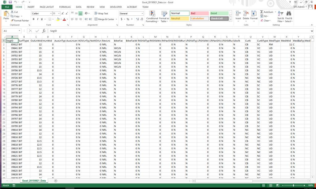
16 Cost Estimation (Cont d) MIRE Element FDE >400 FDE <400 RIDOT Priority Data Type/Collection Methodology I. Roadway Segment Descriptors I.a. Segment Location/Linkage Elements 1 County Name (HPMS FE) 1 admin Have 2 County Code (HPMS FE) 1 admin Have 3 Highway District 1 admin admin 4Type of Governmental Ownership (HPMS FE) x x 1 admin Have 5 Specific Governmental Ownership 1 admin admin 6 City/Local Jurisdiction Name 1 admin admin 7City/Local Jurisdiction Urban Code 1 admin admin 8 Route Number (HPMS FE) x 1 admin admin 9 Route/Street Name (HPMS FE) x 1 admin Have 10 Begin Point Segment Descriptor (HPMS FE) x x 1 admin Have 11 End point Segment Descriptors (HPMS FE) x x 1 admin Have 12 Segment Identifier (HPMS FE) x x 1 admin Have 13 Segment Length (HPMS FE) x 1 admin Have 14 Route Signing (HPMS FE) 1 admin admin 15 Route Signing Qualifier (HPMS FE) 1 admin admin 16Coinciding Route Indicator 1 admin admin Basis of cost estimates Per element cost (where available) Comment 17 Coinciding Route Minor Route Information 1 admin admin 18 Direction of Inventory x 1 admin admin I.b. Segment Classification 19 Functional Class (HPMS FE) x x 1 admin Have 20 Rural/Urban Designation (HPMS FE) x x 1 admin Have 21 Federal Aid/ Route Type (HPMS FE) x 1 admin Have 22 Access Control (HPMS FE) x 1 admin admin I.c. Segment Cross Section I.c.1. Surface Descriptors 23 Surface Type x x 1 imagery, van Utah $26/mile for group 2.1 Roadway Condition Data - IRI 24 Total Paved Surface Width 1 imagery, van Utah $7/mile 4.4 Roadway Asset Data - Surface Areas 25Surface Friction 2 skid trailer previous experience $150/mile 26 Surface Friction Date 2 admin admin 27 Pavement Roughness/Condition (HPMS FE) 1 van Utah $26/mile for group 2.1 Roadway Condition Data - IRI 28 Pavement Roughness Date (HPMS FE) 1 admin admin Pavement Condition (Present Serviceability 29 Rating) Only need if you don t have IRI 30 Pavement Condition (PSR) Date Only need if you don t have IRI I.c.2. Lane Descriptors 31Number Of Through Lanes (HPMS FE) x x 1 imagery, van Utah $7/mile 4.1 Roadway Asset Data - Number and Length of Lanes 32 Outside Through Lane Width 1 imagery, van Utah $7/mile 4.4 Roadway Asset Data - Surface Areas 33 Inside Through Lane Width 1 imagery, van Utah $7/mile 4.4 Roadway Asset Data - Surface Areas 34 Cross Slope 1 imagery, van Utah $26/mile for group 2.5 Roadway Condition Data - Roadway Geometry
17 Data Integration and Governance Data Integration Through ESRI Roads & Highway Implementation Conversion From Multiple LRSs Supporting Various Business Systems to a Unified LRS Platform (While Supporting Multiple LRMS) Supporting Bi-Directional Data Flow and Consistent Location Referencing Across Business Systems Rhode Island Local/State Data Integration For Asset Management and Safety Analysis In Progress Develop processes and identify staffing and resources needed to guarantee the ongoing maintenance and utility of the roadway location and MIRE inventory data Manage data integration and assist the RIDOT in developing processes for integration of the new MIRE data into ESRI Roads and Highways Support use of advanced analytic tools/methodologies through example analyses and training on data extraction/integration processes


18 Automated Sync ing of Business Systems with LRS Business systems Web Service Connections extend access to data inside/ outside the organization, providing access to local & regional government Web services communicate the last synchronization date Web services communicate route and measure changes to business records Local & regional government can participate in the maintenance of the database Rules define how events are updated LRS Change LRS Editor Geodatabase All edit activities are time stamped and stored

19 Roadway Characteristics Editor (RCE) Roads & Highways Road Characteristic Editor (RCE) provides a web portal that can be configured to provide access to local/regional government Local & regional government can actively participate in the maintenance of the road network

20 Data Model MIRE has no standardized data model, only guidance Wanted something basic that could be improved upon Needed something that could easily be edited and moved to various formats


21 Data Collection MAC vehicles collect data along predefined routes Directionality important consideration Mutliple datasets with differing priority levels GPS tracks used to track collection


22 Data Population Data from various sources Aerial imagery ROW imagery (collected by MAC vehicles) LiDAR Existing RIDOT data
23 Data Population


24 Data Population Data populated at 1/10 th of a mile segments Coded domain values used Populated specifically based on type of roadway elements


25 Curves Biggest hurdle with data New process that seemed to have never been done before. Developed Python scripts to detect curves Scripts use point data created from LRS to determine curve start/end measures, length, and radius of curve


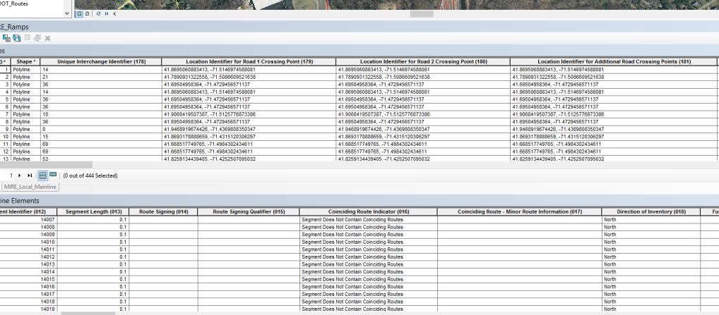
26 QC Before Delivery to RIDOT Initial QC performed by Michael Baker Manual and Automated QC performed Mainline 86,522 segments, 6,932 miles, 120 MIRE Elements Intersections 16,215 intersections, 49,337 intersections approaches, 57 Elements Ramps 444 ramps, 25 Elements
27 QC Before Delivery to RIDOT Manual processes used to QC data using symbology Find areas where symbology differs, and could potentially be errors Applied to attributes such as speed limit, sidewalk presence, median information, etc. Reports delivered in the form of word documents describing issue with screen captures for specific Segment IDs Automated processes Scripts built for cross attribute validation and domain validation Applied to all datasets Validation rules developed based on MIRE guidelines 80 cross attribute validations 90 domain validations Reports delivered to DTS in the form of CSV files with issues listed by Segment ID
28 Lessons Learned/Challenges No standard data model for MIRE Had to develop data model Numerous iterations to work out best geometric and attribute representations Built GDB with domains for all MIRE Elements that could be coded DOTs vs Consulting Managing expectations Keeping all participants up-to-date on project status LRS updates during project
29 Lessons Learned/Challenges (Cont d) FHWA should develop a geospatial data model for use by any agency interested in implementing MIRE. The data model should template GIS feature classes, attribute domains within each feature class, and necessary relationship classes between features. A substantial amount of time was spent by the MIRE Contractor developing a GIS data model to house the MIRE data collection. MIRE Contractor identified the need for additional details for each MIRE element to be located in a single reference document. Although safety engineers are the primarily consumers of the MIRE data, data collection Contractors are more likely to be experts in GIS or mobile data collection technology, without in-depth knowledge of each MIRE element.
30 Lessons Learned/Challenges (Cont d) Require Contractors to document and submit their data collection methodology prior to collecting data. For each MIRE element: Define the element and the attribute type (alpha-numeric, string, integer, double) Identify the source data (Existing GIS, Aerial Photography, ROW Imaging, LiDAR, etc.) Define the process used to extract the element (field calculation, onscreen measurement/count, automated from mobile data collection vehicle) Expected accuracy
31 Lessons Learned/Challenges (Cont d) MIRE junction elements are split between two types of geometry: A point feature with attributes describing the intersection; 3 or more linear features representing the intersection approaches. Each intersection represented as a point with attributes describing the intersection. Intersection approach elements stored in a Related Table and linked to the intersection point based on the intersection identifier. MIRE does not require the intersection approach to be linked to the road segment ID, only the intersection ID. Poses a problem when implementing Safety Analyst and linking crash data to segments and approaches.
32 Moving Forward MIRE Road Inventory to be Imported into Esri Roads & Highways and Managed as part of RIDOT s LRS MIRE elements will be dissolved from 1/10 mile centerline segments into LRS routes with event tables Develop Geoprocessing Tools to Extract Data from Esri Roads & Highways for import into Safety Analyst Safety Analyst will not work with the Esri Roads & Highways event tables Additional data fields (processed from existing attributes) required for import to Safety Analyst MIRE Element Attribute Definitions differ from Safety Analyst Requirements Two Options: Manually attribute map the MIRE attribute definitions within Safety Analyst as part of the data import process Translate MIRE attributes to Safety Analyst definitions through scripting outside of Safety Analyst
33 Sample list of common data elements that may need updating Street name Pavement Surface Type/Width/Condition Lane & Shoulder Type/Width Number of through/left turn/right turn/aux lanes Bike facility (shard lane, bike lane, bike path) Sidewalk Type/Presence Curb Type/Presence Median Type/Presence/Width Driveway (residential and commercial) Count Intersection Control (signalized, stop, uncontrolled, pedestrian) Speed Limits On-Street Parking School Zones Crosswalk Lighting Pavement Markings Rumble Strips Passing Zones

34 Comments & Questions
RIDOT S Statewide Roadway and Asset Data Collection Project
 RIDOT S Statewide Roadway and Asset Data Collection Project ESRI User Conference 2017 Rafiq Basaria, DTS; Daniel Behnke DTS, Shane White, RIDOT Accent image here Primary Image here What is MIRE? Recommended
Roadway Data Extraction Technical Assistance Program (RDETAP) Traffic Safety Conference College Station, June 2016
 Traffic Safety Conference College Station, June 2016") Roadway Data Extraction Technical Assistance Program (RDETAP) Traffic Safety Conference College Station, June 2016 Overview Project motivation and objectives MIRE-MIS Program RDETAP Project Overview of
Roadway Data Extraction Technical Assistance Program (RDETAP) Traffic Safety Conference College Station, June 2016 Overview Project motivation and objectives MIRE-MIS Program RDETAP Project Overview of
Roadway Data Extraction Technical Assistance Program (RDETAP)
") Roadway Data Extraction Technical Assistance Program (RDETAP) 41 st International Forum on Traffic Records and Highway Information Systems October 2015 Overview Project motivation and objectives MIRE MIS
Roadway Data Extraction Technical Assistance Program (RDETAP) 41 st International Forum on Traffic Records and Highway Information Systems October 2015 Overview Project motivation and objectives MIRE MIS
Model Inventory of Roadway Elements (MIRE) GIS-T Annual Conference March 30, Robert Pollack FHWA
 GIS-T Annual Conference March 30, Robert Pollack FHWA") Model Inventory of Roadway Elements (MIRE) GIS-T Annual Conference March 30, 2011 Robert Pollack FHWA What is MIRE? Model Inventory of Roadway Elements Listing of roadway and traffic elements critical
Model Inventory of Roadway Elements (MIRE) GIS-T Annual Conference March 30, 2011 Robert Pollack FHWA What is MIRE? Model Inventory of Roadway Elements Listing of roadway and traffic elements critical
Assembling MIRE Data. The Vermont Experience. Vermont Agency of Transportation (VTrans) Mapping Section
 Mapping Section") Assembling MIRE Data The Vermont Experience A look into the development of GIS-based intersection data Vermont Agency of Transportation (VTrans) Mapping Section March 20, 2018 Embarking on the Task of
Assembling MIRE Data The Vermont Experience A look into the development of GIS-based intersection data Vermont Agency of Transportation (VTrans) Mapping Section March 20, 2018 Embarking on the Task of
NJDOT: Asset Management Strategies and Tools
 NEW JERSEY DEPARTMENT OF TRANSPORTATION NJDOT: Asset Management Strategies and Tools Wednesday, October 1, 2014 Afternoon Session (1:45pm 2:30pm) Presenters Michael Castaldo New Jersey Department Of Transportation
One Maryland One Centerline. GIS-T 2014 May 7, 2014
 One Maryland One Centerline GIS-T 2014 May 7, 2014 Current Road Centerlines in Maryland SHA maintains a statewide centerline Supports HPMS program Represents state and local roads Capturing dual carriageways
Roadway Intersection Inventory and Remote Sensing
 Veneziano 1 Roadway Intersection Inventory and Remote Sensing David Veneziano Center for Transportation Research and Education Iowa State University ABSTRACT The application of remote sensing to the collection
2017 Highway Safety Improvement Program Call
 2017 Highway Safety Improvement Program Call The Highway Safety Improvement Program (HSIP) is for highway safety projects that eliminate or reduce the number of fatalities and serious injuries on all public
Esri Roads and Highways An Introduction
 Esri International User Conference San Diego, California Technical Workshops July 24, 2012 Esri Roads and Highways An Introduction William Isley Majunu Seran Agenda Product Overview Desktop - Demo: Network
Esri Roads and Highways An Introduction. Nathan Easley Rahul Rakshit
 Esri Roads and Highways An Introduction Nathan Easley Rahul Rakshit Roads and Highways Linear Referencing for the Transportation Enterprise GIS-enabled LRS platform LRS management LRS editing & maintenance
Integrating MAP-21 Asset Management Data Using Esri s Roads and Highways. Imagine the result
 Integrating MAP-21 Asset Management Data Using Esri s Roads and Highways Imagine the result 1 17 2012 October ARCADIS 2014 Presenters David Ward Project Manger and Principal Architect for AzDOT Roads and
GIS-BASED NON-SIGNALIZED INTERSECTION DATA INVENTORY TOOL TO IMPROVE TRAFFIC SAFETY
 Simandl, Graettinger, Smith, Barnett 0 0 0 GIS-BASED NON-SIGNALIZED INTERSECTION DATA INVENTORY TOOL TO IMPROVE TRAFFIC SAFETY Jenna K. Simandl*, Andrew J. Graettinger, Randy K. Smith, Timothy E. Barnett
Implementing an Asset and Pavement Management System in Alexandria, VA. Craig Schorling, GISP Business Development Manager, Transmap Corporation
 Implementing an Asset and Pavement Management System in Alexandria, VA Craig Schorling, GISP Business Development Manager, Transmap Corporation Alexandria Statistics Located on the Western bank of the
LOCATION AND DESIGN DIVISION
 VIRGINIA DEPARTMENT OF TRANSPORTATION LOCATION AND DESIGN DIVISION INSTRUCTIONAL AND INFORMATIONAL MEMORANDUM GENERAL SUBJECT: Design Exceptions / Waivers SPECIFIC SUBJECT: Design Exception Request Form
CHAPTER 3 SCOPE SUMMARY
 CHAPTER 3 SCOPE SUMMARY GENERAL The SDDOT is an active member of AASHTO to share common national design standards for the state highway system. The AASHTO Task Force on Geometric Design has completed the
Engineering Design Services for Safety Improvements along CR 476 from the Hernando County Line to US 301 (SR 35) Sumter County, Florida
 Sumter County, Florida") Engineering Design Services for Safety Improvements along CR 476 from the Hernando County Line to US 301 (SR 35) Sumter County, Florida November 7, 2014 SUBMITTED BY: Dewberry Bowyer-Singleton 520 South
Engineering Design Services for Safety Improvements along CR 476 from the Hernando County Line to US 301 (SR 35) Sumter County, Florida November 7, 2014 SUBMITTED BY: Dewberry Bowyer-Singleton 520 South
An Introduction to the. Safety Manual
 An Introduction to the Highway Safety Manual An Introduction to the HIGHWAY SAFETY MANUAL Table of Contents Section 1: HSM Overview... 1 What is the Highway Safety Manual?... 1 How is the HSM Applied?...
Adaptation of HERS-ST Models for the South Carolina Interactive Interstate Management System
 Adaptation of HERS-ST Models for the South Carolina Interactive Interstate Management System presented to the Transportation Research Board HERS Modeling and Data Integration Conference presented by William
FDOT D7 Local Agency Traffic Safety Academy September 21, FHWA - Kevin Burgess, Chimai Ngo, Esther Strawder, and Jim Thorne
 FDOT D7 Local Agency Traffic Safety Academy September 21, 2016 FHWA - Kevin Burgess, Chimai Ngo, Esther Strawder, and Jim Thorne Presenters Kevin Burgess FHWA Florida Division Safety Engineer Chimai Ngo
TRANSPORTATION RESEARCH BOARD. Spatial Modeling for Highway Performance Monitoring System Data: Part 1. Tuesday, February 27, :00-4:00 PM ET
 TRANSPORTATION RESEARCH BOARD Spatial Modeling for Highway Performance Monitoring System Data: Part 1 Tuesday, February 27, 2018 2:00-4:00 PM ET The Transportation Research Board has met the standards
TABLE OF CONTENTS. Manual Section. Introduction 1. Using This Manual 2-3. Administrative Actions 4-6. Road and Bridge Project Types 7
 ii TABLE OF CONTENTS Manual Section Pages Introduction 1 Using This Manual 2-3 Administrative Actions 4-6 Road and Bridge Project Types 7 Road and Bridge Funding Programs 8-9 Project Planning and Eligible
Metropolitan Planning Organization Safety Performance Measures Fact Sheet
 waco mpo Metropolitan Planning Organization Safety Performance Measures Fact Sheet Safety Performance Measures The Safety Performance Management Measures regulation supports the Highway Safety Improvement
The sections below include examples of HSM implementation activities undertaken by various transportation agencies.
 NCHRP 17-50 TECHNICAL BRIEFINGS This series of technical briefings provide a reference for highway agencies that are interested in initiating the implementation of the American Association of State Highway
USING GIS TO DEVELOP AN INTERSECTION INVENTORY FOR SAFETY
 USING GIS TO DEVELOP AN INTERSECTION INVENTORY FOR SAFETY Nancy X. Lefler (corresponding author) Vanasse Hangen Brustlin, Inc. Fayetteville Street, Suite 0 Raleigh, NC 0 Phone: -- Fax: --0 nxlefler@vhb.com
Presented by John Hudler Geospatial Group Leader Office of Transportation Data Georgia Department of Transportation
 Presented by John Hudler Geospatial Group Leader Office of Transportation Data Georgia Department of Transportation Collection, Quality Assurance and Reporting of the States roadway and transportation
HIGH RISK RURAL ROADS (HRRR)
") APPENDIX #1 HIGH RISK RURAL ROADS (HRRR) 6. High Risk Rural Roads The Puerto Rico Highway and Transportation Authority (PRHTA) evaluated the need to identify high risk rural roads within the State highway
APPENDIX #1 HIGH RISK RURAL ROADS (HRRR) 6. High Risk Rural Roads The Puerto Rico Highway and Transportation Authority (PRHTA) evaluated the need to identify high risk rural roads within the State highway
Office of Transportation Data (OTD)
") Office of Transportation Data (OTD) Paul Tanner State Transp o rtatio n D ata A d m inistrato r Presentation Objectives Why do we collect data? State & Federal Code Requirements Who collects the data?
Office of Transportation Data (OTD) Paul Tanner State Transp o rtatio n D ata A d m inistrato r Presentation Objectives Why do we collect data? State & Federal Code Requirements Who collects the data?
Using ArcGIS Online to Support Transportation Engineering. ESRI Southeast User Conference May 2, 2016 Daniel R. Mellott, GISP Sain Associates
 Using ArcGIS Online to Support Transportation Engineering ESRI Southeast User Conference May 2, 2016 Daniel R. Mellott, GISP Sain Associates Presentation Overview Horizontal Curve History Project Obstacles
Esri Roads and Highways Solution Overview. Eric Floss Transportation Practice Manager
 Esri Roads and Highways Solution Overview Eric Floss Transportation Practice Manager Agenda Esri LRS Solution Briefing Advanced Linear Referencing Support User Interface Experience Open Discussion GIS
All Roads Do Not End at the State Line: Methodologies for Enabling Geodata Sharing Across Boundaries
 All Roads Do Not End at the State Line: Methodologies for Enabling Geodata Sharing Across Boundaries presented to 22 nd Geospatial Information Systems for Transportation Symposium presented by Julie Chizmas,
Safety Management System for Israel
 Safety Management System for Israel Dr. Simon Lewis and Joe Garvey AgileAssets, Inc. Traffic Records Forum New Orleans July 27, 2010 A nation under pressure * Do things well /smart * Do things right first
Urban Arterial Roads Pavement Data Collection. October 23, 2012 Todd M. Halacy, P.E. VDOT Local Assistance Division
 Urban Arterial Roads Pavement Data Collection October 23, 2012 Todd M. Halacy, P.E. VDOT Local Assistance Division Presentation Topics Background Information: CTB Subcommittee & Local Government Workgroup
REQUIREMENTS WEBINAR FEBRUARY 20, :00 2:30 P.M.
 ENHANCED NATIONAL HIGHWAY SYSTEM AND REQUIREMENTS WEBINAR FEBRUARY 20, 2013 1:00 2:30 P.M. Webinar Housekeeping Tips There is a designated time at the end of the presentation for questions and answers.
Performance Based Practical Design (PBPD)
") Performance Based Practical Design (PBPD) 2016 ODOT D08 LPA Day John R. Kasich, Ohio Governor Jerry Wray, ODOT Director PBPD PBPD Presenter Katherine DeStefano, P. E. District 08 Design Engineer ODOT D08
Performance Based Practical Design (PBPD) 2016 ODOT D08 LPA Day John R. Kasich, Ohio Governor Jerry Wray, ODOT Director PBPD PBPD Presenter Katherine DeStefano, P. E. District 08 Design Engineer ODOT D08
NYSDOT Roadway Inventory. Both On and Off the State System
 NYSDOT Roadway Inventory Both On and Off the State System 1 2 NYSDOT Highway Data Services Bureau Highway Data Traffic Monitoring Pavement Data Inventory of public roads, incl. LHI Systems designations
GEOMETRIC DESIGN CRITERIA for Non-freeway Resurfacing, Restoration, and Rehabilitation Projects
 GEOMETRIC DESIGN CRITERIA for Non-freeway Resurfacing, Restoration, and Rehabilitation Projects SEPTEMBER 1989 Arkansas State Highway and Transportation Department GEOMETRIC DESIGN CRITERIA for Non-freeway
HSM APPLICATION USING IHSDM (I-12 TO BUSH) April Renard, P.E. LADOTD Highway Safety
 April Renard, P.E. LADOTD Highway Safety") HSM APPLICATION USING IHSDM (I-12 TO BUSH) April Renard, P.E. LADOTD Highway Safety PROJECT OVERVIEW Alternative N-S corridor to I-12 Louisiana Revised Statute 47:820.2B(e) 4-lane arterial Limited access
HSM APPLICATION USING IHSDM (I-12 TO BUSH) April Renard, P.E. LADOTD Highway Safety PROJECT OVERVIEW Alternative N-S corridor to I-12 Louisiana Revised Statute 47:820.2B(e) 4-lane arterial Limited access
OPEN DATA & PROJECT TRACKER. Michael Chamberlain TPP, Data Management
 OPEN DATA & PROJECT TRACKER Michael Chamberlain TPP, Data Management October 11, 017 Table of contents 1 People 3 Attributes 4 3 Locations 5 4 Systems 6 5 Reports 7-8 6 Applications 8-13 7 Closing 14 Data
Eng. Benjamín Colucci-Ríos, PhD, PE, PTOE, FITE, API, JD
 An Overview of Innovative Safety Initiatives to Create Awareness and Save Lives on Puerto Rico Highways & Local Road Safety Checklist Eng. Benjamín Colucci-Ríos, PhD, PE, PTOE, FITE, API, JD benjamin.colucci1@upr.edu
Using Random Samples to Assess Roadway Condition. Faith Johnson GIS Specialist, NCDOT
 Using Random Samples to Assess Roadway Condition Faith Johnson GIS Specialist, NCDOT North Carolina Highway System 79,600 miles of state maintained roads Interstate: 1,326 Primary: 13,736 Secondary: 64,522
Managing Ancillary Pavements: A Survey of Practice and Related Resources
 TRS 1507 January 2016 Managing Ancillary Pavements: A Survey of Practice and Related Resources The purpose of this TRS is to serve as a synthesis of pertinent completed research to be used for further
ArcGIS for Transportation. Tom Brenneman, Gary Waters
 ArcGIS for Transportation Tom Brenneman, Gary Waters ArcGIS for Transportation A product for Esri s transportation customers A series of useful maps and apps focused on transportation Organized into modules
By Andrew Lindsay Government of Manitoba Manitoba Infrastructure and Transportation (MIT) Highway Planning and Design
 Highway Planning and Design") By Andrew Lindsay Government of Manitoba Manitoba Infrastructure and Transportation (MIT) Highway Planning and Design Information on the Province of Manitoba Brief history of MIT s linear referencing system
By Andrew Lindsay Government of Manitoba Manitoba Infrastructure and Transportation (MIT) Highway Planning and Design Information on the Province of Manitoba Brief history of MIT s linear referencing system
100 Design Controls and Exceptions
 100 Design Controls and Exceptions Table of Contents 100 Introduction... 1 101 Functional Classification... 1 101.1 General... 1 101.2 Urban & Rural... 1 101.3 Classification Used In ODOT Design Criteria...
Process to Identify High Priority Corridors for Access Management Near Large Urban Areas in Iowa Using Spatial Data
 Process to Identify High Priority Corridors for Access Management Near Large Urban Areas in Iowa Using Spatial Data David J. Plazak and Reginald R. Souleyrette Center for Transportation Research and Education
TOM MAZE TRANSPORTATION SEMINAR
 TOM MAZE TRANSPORTATION SEMINAR IOWA STATE UNIVERSITY APRIL 11, 2014 TONY FURST ASSOCIATE ADMINISTRATOR, SAFETY FEDERAL HIGHWAY ADMINISTRATION RESEARCH SHRP2 Data Driven Analysis Problem Identification
Chapter 1. General Design Information. Section 1.02 Structure Selection and Geometry. Introduction
 Chapter 1 Bridge Design Manual General Design Information Section 1.02 Selection and Geometry Introduction Selection or Rehabilitation Report This section of the design manual provides guidance on the
The Role of PMS in the DOTD Decision Making Process
 The Role of PMS in the DOTD Decision Making Process Christophe N. Fillastre, P.E. CE Louisiana Department of Transportation and Development Section 21, Management Systems and Data Collection Pavement Management
Status of Highway Safety Manual Implementation. October 2015
 Status of Highway Safety Manual Implementation October 2015 Agenda NCHRP Project 17-50 Overview Project Objective Panel members and support states Project Deliverables to Date Status of HSM Implementation
ROAD SAFETY AUDIT CONFEDERATED SALISH & KOOTENAI TRIBES
 2017 NW TTAP & BIA Symposium Spokane, WA ROAD SAFETY AUDIT CONFEDERATED SALISH & KOOTENAI TRIBES Presenter: Gabriel Johnson, P.E. Natural Resources Department Roads Program Manager The Confederated Salish
Conclusions & Lessons Learned
 What is a DDI Recommended Practices Traffic Operations Analysis Geometric Design FHWA Review Conclusions & Lessons Learned It s not about you, it s about the public Developed by Access Utah County
100 Introduction Functional Classification Traffic Data Terrain & Locale Design & Legal Speed...
 Table of Contents 100 Introduction... 1 101 Functional Classification... 1 101.1 General...1 101.2 Urban & Rural...1 101.3 Classification Used in ODOT Design Criteria...1 102 Traffic Data... 2 102.1 General...2
NYSAMPO Association GIS Working Group Friday, May 23, 2014
 NYSAMPO Association GIS Working Group Friday, May 23, 2014 Participating: A/GFTC Kate Mance CDTC Teresa LaSalle ECTC Mike Perry GTC Chris Tortora HOCTS Jeff Quackenbush, Erin Tylutki NYMTC Munnesh Patel
APPENDIX C INLETS. The application and types of storm drainage inlets are presented in detail in this Appendix.
 Storm Drainage 13-C-1 APPENDIX C INLETS 1.0 Introduction The application and types of storm drainage inlets are presented in detail in this Appendix. 2.0 Inlet Locations Inlets are required at locations
Overview of Maintenance and Construction Programs. Mike Holder, PE, Chief Engineer Jennifer Brandenburg, PE, State Asset Management Engineer
 Overview of Maintenance and Construction Programs Mike Holder, PE, Chief Engineer Jennifer Brandenburg, PE, State Asset Management Engineer March 3, 2015 Overview Maintenance and Construction State v.
Evaluating Design Alternatives using Crash Prediction Methods from the Highway Safety Manual
 Evaluating Design Alternatives using Crash Prediction Methods from the Highway Safety Manual Andrew Ooms November 2012 Outline Safety Overview Current practices Safety Fundamentals Introduction the Highway
CHAPTER 4 GRADE SEPARATIONS AND INTERCHANGES
 CHAPTER 4 GRADE SEPARATIONS AND INTERCHANGES 4.0 INTRODUCTION The ability to accommodate high volumes of intersecting traffic safely and efficiently through the arrangement of one or more interconnecting
RAC Focus Group Priorities Agency Wide 2013 Question Is there a Better Way?
 Prioritization of All Research Ideas 2012 The RAC Focus groups Started meeting in June 2012 to brainstorm ideas for upcoming research that would begin in FY2013. The areas comprised of four major areas:
Process to Identify High Priority Corridors for Access Management Near Large Urban Areas in Iowa
 Process to Identify High Priority Corridors for Access Management Near Large Urban Areas in Iowa David Plazak and Reg Souleyrette Center for Transportation Research and Education Iowa State University
Curb Ramps [ 4.7.3] [ 4.7.2; 4.8.2; 4.1.6(3)(a)] [ 4.3.7] ADA Accessibility Survey Instructions Curb Ramps Page 1 of 6
![Curb Ramps [ 4.7.3] [ 4.7.2; 4.8.2; 4.1.6(3)(a)] [ 4.3.7] ADA Accessibility Survey Instructions Curb Ramps Page 1 of 6](/thumbs/73/68272859.jpg "Curb Ramps [ 4.7.3] [ 4.7.2; 4.8.2; 4.1.6(3)(a)] [ 4.3.7] ADA Accessibility Survey Instructions Curb Ramps Page 1 of 6") : Curb Ramps 1 [ 4.7.3] Only measure the width of the ramp section of the curb ramp (labeled ramp to the right). The ramp section of a curb ramp is also known as the ramp run. If the curb ramp has flared
: Curb Ramps 1 [ 4.7.3] Only measure the width of the ramp section of the curb ramp (labeled ramp to the right). The ramp section of a curb ramp is also known as the ramp run. If the curb ramp has flared
South Carolina DOT Data Driven Intersection Safety Improvements
 South Carolina DOT Data Driven Intersection Safety Improvements Intersection Safety Data Nationwide: 21 % of all fatalities occur at or near intersections, as well as 52 % of all injuries 45 % of all
Highway Safety Analysis Tools for Engineers
 Highway Safety Analysis Tools for Engineers Xiaoduan Sun University of Louisiana Lafayette Dan Magri Hadi H. Shirazi Louisiana Department of Transportation and Development The 2007 Louisiana Transportation
PERFORMANCE BASED PRACTICAL DESIGN
 PERFORMANCE BASED PRACTICAL DESIGN DOT S FACE INCREASING CHALLENGES ENGINEERING CULTURE We learned from those who taught us how and why we follow the standards There are valid reasons that tell us we now
Design of rural and urban roads contributes a lot towards safety of users. Identify some low-cost
 COST EFFECTIVE DESIGNS TO IMPROVE HIGHWAY SAFETY Author: Brent T Allman, E.I.T. Construction Engineering Arizona State University Responding to the following Topic: Design of rural and urban roads contributes
TRAFFIC ENGINEERING DIVISION
 VIRGINIA DEPARTMENT OF TRANSPORTATION TRAFFIC ENGINEERING DIVISION INSTRUCTIONAL & INFORMATIONAL MEMORANDUM GENERAL SUBJECT: Administrative and Engineering SPECIFIC SUBJECT: Sealing and Signing of Traffic
Table of Contents TOC. General Information. Street Classifications. Geometric Design Criteria
 Design Manual Chapter 5 - Roadway Design Table of Contents TOC Table of Contents Chapter 5 - Roadway Design 5A General Information 5A-1---------------------------------General Information A. Concept.....
AASHTO s Highway Safety Manual and Performance Measures / Targets
 AASHTO s Highway Safety Manual and Performance Measures / Targets Dr. Anthony Kane Director of Engineering and Technical Services Wednesday October 26, 2011 Bom dia damas e cavalheiros Talk Overview Highway
Project Initiation Form
 Meeting Date: The Project Initiation Form should be completed in conjunction with the Level 2 Screening Form. Process Leads and/or Planners should complete the Project Initiation Form to document coordination
Asset Management and Data Collection using Digital Video / GPS Data Extraction Techniques
 Asset Management and Data Collection using Digital Video / GPS Data Extraction Techniques TRB 6 th National Conference on Transportation Asset Management Kansas City, Missouri November 2, 2005 Presentation
Metropolitan Planning Organization Safety Performance Measures Fact Sheet
 Metropolitan Planning Organization Safety Fact Sheet Safety The Safety Performance Management Measures regulation supports the Highway Safety Improvement Program (HSIP) and requires State Departments of
2 Purpose and Need. 2.1 Study Area. I-81 Corridor Improvement Study Tier 1 Draft Environmental Impact Statement
 2 Purpose and Need 2.1 Study Area Interstate 81 (I-81) is relied upon for local and regional travel and interstate travel in the eastern United States. It extends 855 miles from Tennessee to New York at
Highway Safety Manual Lead State Third Peer Exchange Nashville, Tennessee
 SUMMARY REPORT Highway Safety Manual Lead State Third Peer Exchange Nashville, Tennessee NCHRP Research Project Statement 17-50 Lead States Initiative for Implementing the Highway Safety Manual Submitted
Transportation Asset Management Webinar Series
 Transportation Asset Management Webinar Series Webinar 34 Integrating PM2 Targets with the TAMP Sponsored by FHWA and AASHTO Webinar 34 October 10, 2018 FHWA-AASHTO Asset Management Webinar Series This
City of DeBary, FL Sidewalk Data Collection Services
 City of DeBary, FL Sidewalk Data Collection Services Prepared by: Data Transfer Solutions, LLC 2680 Avalon Park Blvd. East, Suite 200 Orlando, FL 32828 www.dtsgis.com 1 COVER LETTER May 30, 2017 Mr. Matt
Extending Linear Referencing System (LRS) capabilities to Pipeline organizations. Anjali Bhangay and Summer Hall
 capabilities to Pipeline organizations. Anjali Bhangay and Summer Hall") Extending Linear Referencing System (LRS) capabilities to Pipeline organizations Anjali Bhangay and Summer Hall Pipeline Referencing Functionalities and Capabilities Information Model Data Management Geoprocessing
Extending Linear Referencing System (LRS) capabilities to Pipeline organizations Anjali Bhangay and Summer Hall Pipeline Referencing Functionalities and Capabilities Information Model Data Management Geoprocessing
Oregon Transportation Commission Members: Oregon Transportation Safety Committee Members:
 Amendment One to the 2004 Oregon Transportation Safety Action Plan was recommended for approval by the Oregon Transportation Safety Committee on July 18, 2006. The plan amendment was formally adopted by
ROADWAY DESIGN AND CONSTRUCTION STANDARDS
 ROADWAY DESIGN AND CONSTRUCTION STANDARDS Adopted: 1990 Amended: 1994 2003 2011 2013 ROADWAY DESIGN AND CONSTRUCTION STANDARDS ORIGINALLY ADOPTED IN 1990 Resolution No. R-990-046 OFFICIALLY AMENDED IN
Hot Topics and Trends in Highway Safety in Indiana. Rick O. Drumm, P.E. Safety Engineer FHWA Indiana Division Road School 2012 March 7, 2012
 Hot Topics and Trends in Highway Safety in Indiana Rick O. Drumm, P.E. Safety Engineer FHWA Indiana Division Road School 2012 March 7, 2012 Hot Topics and Trends Safety is a good thing. UPDATED!!!! Hot
Project Update. Roads and Highways Implementation. Emiko Hori. West Virginia Department of Transportation
 Roads and Highways Implementation at WVDOT Project Update Emiko Hori Geospatial Transportation Information (GTI) Section Geographic Information System (GIS) Unit Agenda 1. Development History 2. Roads
Boster, Kobayashi & Associates NEVIN Q. SAMS, P.E., T.E., P.T.O.E.
 Boster, Kobayashi & Associates 59 Rickenbacker Circle Office: (925) 447-6495 P.O. Box 2049 Fax: (925) 447-6589 Livermore, CA 94551-2049 NEVIN Q. SAMS, P.E., T.E., P.T.O.E. Curriculum Vitae EDUCATION: B.S.
Chapter DESIGN EXCEPTION PROCESS
 Chapter 14 DESIGN EXCEPTION PROCESS 14.1 GENERAL The information in this section describes the design exception process for planning studies and project development projects. In addition, this section
The Costs & Benefits of Implementing a MLLRS. Sponsored by the AASHTO and FHWA and Conducted in the NCHRP
 The Costs & Benefits of Implementing a MLLRS Sponsored by the AASHTO and FHWA and Conducted in the NCHRP Value Engineering OThis presentation is based on the value engineering study that was conducted
Updating Virginia s Statewide Functional. Brad Shelton, VDOT Chris Detmer, VDOT Ben Mannell, VDOT
 Updating Virginia s Statewide Functional Classification System Brad Shelton, VDOT Chris Detmer, VDOT Ben Mannell, VDOT July 18, 2013 What is Functional Classification Use of Functional Classification Today
Automated Statewide Highway Intersection Safety Data Collection and Evaluation Strategy
 Automated Statewide Highway Intersection Safety Data Collection and Evaluation Strategy Fan Yang, Ph.D. Candidate Department of Civil and Environmental Engineering, University of Wisconsin-Madison, Madison,
Municipal DataWorks INVENTORY MANUAL for Municipal Transportation Networks
 Municipal DataWorks INVENTORY MANUAL for Municipal Transportation Networks September 2008 Ontario Good Roads Association 1 INTRODUCTION This manual provides a uniform method of inventorying the physical
EXHIBIT A SCOPE OF SERVICES FOR FINANCIAL PROJECT ID TRANSPORTATION SYSTEM MANAGEMENT & OPERATIONS (TSM&O) GENERAL CONSULTANT SERVICES
 GENERAL CONSULTANT SERVICES") EXHIBIT A SCOPE OF SERVICES FOR FINANCIAL PROJECT ID 432430-1-32-13 TRANSPORTATION SYSTEM MANAGEMENT & OPERATIONS (TSM&O) GENERAL CONSULTANT SERVICES DISTRICT TWO November 27, 2017 Page 1 EXHIBIT A SCOPE
EXHIBIT A SCOPE OF SERVICES FOR FINANCIAL PROJECT ID 432430-1-32-13 TRANSPORTATION SYSTEM MANAGEMENT & OPERATIONS (TSM&O) GENERAL CONSULTANT SERVICES DISTRICT TWO November 27, 2017 Page 1 EXHIBIT A SCOPE
PLANNING SNAPSHOT 7:
 PLANNING SNAPSHOT 7: CRASH DATA JANUARY 2016 Funded through the NCHRP 8-36 Research Series, these snapshots are designed to tell you a little about the current state of a specific planning practice of
STATE OF ALASKA RFP NUMBER 2515H005 AMENDMENT NUMBER FIVE (5)
") STATE OF ALASKA RFP NUMBER 2515H005 AMENDMENT NUMBER FIVE (5) AMENDMENT ISSUING OFFICE: Department of Transportation & Public Facilities Statewide Contracting & Procurement P.O. Box 112500 (3132 Channel
STATE OF ALASKA RFP NUMBER 2515H005 AMENDMENT NUMBER FIVE (5) AMENDMENT ISSUING OFFICE: Department of Transportation & Public Facilities Statewide Contracting & Procurement P.O. Box 112500 (3132 Channel
Shoulder Widening Prioritization Discussion
 Shoulder Widening Prioritization Discussion Lindsey Bruer Planning Director March 2, 2018 District 8 ATP Meeting mndot.gov District 4 Shoulder Widening Study Evaluation Criteria: 3/8/2018 2 Evaluation
Peterborough County Road Safety Audit Guideline Pilot
 Peterborough County Pilot Table of Contents 1.0 Purpose... 3 2.0 Road Safety Audit Objectives... 3 3.0 Legal Issues... 3 4.0 Road Safety Audit Procedures... 4 4.1 Project Selection Criteria... 5 4.2 Scope...
FDOT State Safety Office History, Accomplishments & Planned FHWA Funded Efforts. Presenters: Kathryn Waters & Joseph Santos July 29, 2015
 FDOT State Safety Office History, Accomplishments & Planned FHWA Funded Efforts Presenters: Kathryn Waters & Joseph Santos July 29, 2015 Welcome & Introductions Name Organization Your Role & Responsibility
PWC Neighborhood Services Conference. February 20, 2016 Aleksandra Tuliszka Assistant Transportation and Land Use Director
 PWC Neighborhood Services Conference February 20, 2016 Aleksandra Tuliszka Assistant Transportation and Land Use Director www.virginiadot.org Overview: VDOT s primary Function The Virginia Department of
Douglas Woods Wind Farm
 Traffic Evaluation and Access Management Report Douglas Woods Wind Farm Douglas,Massachusets Prepared for American Pro Wind 195 Libbey Parkway - Unit Two Weymouth, MA 02189 Prepared by Transportation,
Data Driven Results: North Carolina s Strategic Prioritization Process through SPOT On!ine. NCDOT Strategic Prioritization Office April 4, 2016
 Data Driven Results: North Carolina s Strategic Prioritization Process through SPOT On!ine NCDOT Strategic Prioritization Office April 4, 2016 Agenda Why We Prioritize Background Strategic Investments
Geometric Design: Past, Present, and Future
 A2A02: Committee on Geometric Design Chairman: Daniel B. Fambro Geometric Design: Past, Present, and Future DANIEL B. FAMBRO, Texas A&M University JOHN C. COLLINGS, Delcan Corporation ROBERT DELLA VEDOVA,
Chapter 8. Inlets. 8.0 Introduction. 8.1 General
 . Introduction This chapter provides criteria and design guides for evaluating and designing storm sewer inlets in the City of Centennial. The review of all planning submittals will be based on the criteria
Eating at the GIS Buffet. Yelena Kalashnikova Elizabeth Ervin Thebo
 Eating at the GIS Buffet Yelena Kalashnikova Elizabeth Ervin Thebo SCDOT GIS Office A small office of 13 staff some contractor some FT) Responsibilities include Maintaining geometry and key attribute information
SAFETY IMPACT OF HIGH FRICTION SURFACE TREATMENT INSTALLATIONS IN PENNSYLVANIA
 0 0 0 SAFETY IMPACT OF HIGH FRICTION SURFACE TREATMENT INSTALLATIONS IN PENNSYLVANIA Kimberley Musey Graduate Research Assistant Department of Civil and Environmental Engineering Villanova University 00
Building West Virginia DOT s Geospatial Capabilities:
 Building West Virginia DOT s Geospatial Capabilities: GIS Web Portal And Straight-line Diagram Application Current Status, Upcoming Enhancements, and Integration Marshall Burgess, WVDOT Don Kiel, GeoDecisions