TRANSPORTATION MOBILITY PLAN GUIDELINES
|
|
|
- Alfred Johnathan Powell
- 6 years ago
- Views:
Transcription

1 TRANSPORTATION MOBILITY PLAN GUIDELINES for Development Applications November 2016

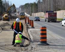
2 Executive Summary The Regional Municipality of York (the Region) is located in the heart of the Greater Toronto Area (GTA) in Southern Ontario. York Region is comprised of nine local municipalities covering approximately 1,776 square kilometres, stretching from the City of Toronto in the south to Lake Simcoe and the Holland Marsh in the north, and bounded by Peel Region in the west and Durham Region in the east. Growth in the Region York Region is expected to grow to 1.79 million residents and 900,000 jobs by Given the significance of this growth, it is important to integrate land use with transportation planning to create complete and sustainable communities. This is consistent with the Regional and Municipal Official Plans and Transportation Master Plans. As the Region matures towards a more urban environment, growth and development cannot be assessed solely on its impact on road capacity and intersection operations. Within many developed areas across the Region, the existing transportation network for automobile use has reached or is near capacity. For these reasons, traditional transportation impact studies must identify policy, program improvements, and the infrastructure requirements necessary to move people and goods across a multimodal (walking, cycling, taking transit, and driving) transportation environment. Construction on the Davis Drive rapidway, Town of Newmarket The Regional Transportation Master Plan indicates that The future success of York Region as the number one destination within the GTHA for people to live, work and play is dependent on the Region s ability to build an interconnected system of mobility. Managing the demand for travel generated by new developments is a potentially powerful strategy for controlling costs, mitigating environmental impacts, and possibly permitting developments to proceed in road capacity constrained areas. Land use and transportation To address future requirements, the Region Official Plan (2010), as amended, requires that communities be designed to provide an enhanced mobility system using a people and transit first approach. This would connect land use and transportation planning by balancing pedestrians, cyclists, public transit and automobile users, through the sustainability initiatives identified in the Transportation Master Plan Update and other development guidelines, such as the Region s New Communities Guidelines (2013). The New Communities Guidelines have been created to assist the nine local municipalities within York Region and the development industry in successfully implementing the sustainable building and new community areas policies in the Regional Official Plan. I
3 Purpose of the guidelines As part of the approval process, the Region and the nine local municipalities within York Region require development applications to provide a Transportation Impact Study to assess the impacts of the proposed development on the existing and future transportation network. This requirement will be even more important in the future because parts of the Region s transportation network are already constrained. The Regional Official Plan and Transportation Master Plan contain strong policies and requirements emphasizing the goals of sustainability, alternative modes of transportation and mobility. The Transportation Mobility Plan Guidelines are the implementation tools, providing the bridges required to implement and connect the policies and requirements in the Official Plans and Transportation Master Plans. The Transportation Mobility Plan Guidelines also consolidate most of the Regional and local municipal requirements into one document. A Transportation Mobility Plan is simply a combination of a multimodal mobility plan along with the traditional transportation impact study analyses. The Transportation Mobility Plan is required to support all development applications in York Region that have potential impacts on Regional and local transportation systems. The Transportation Mobility Plan focuses more on transit, active transportation and measures that will reduce the travel demand and minimize single-occupant vehicle trips to and from the proposed developments. The Transportation Mobility Plan Guidelines for Development Applications is an update to the Region s existing Transportation Impact Study Guidelines for Development Applications (2007) and builds on other documents to provide greater clarity and detail on appropriate data sources and methods related to active transportation and transit: New Communities Guidelines (2013) Transit Oriented Development Guidelines (September 2006) Access Guideline for Regional Roads From a transportation planning perspective, a Transportation Mobility Plan will help expedite the development review process and provide benefits for both review agencies and applicants, including: Reducing Regional and local municipal staff review time for supporting transportation studies as both staff and transportation specialists will follow the same set of guidelines Requiring fewer iterations and revisions to reports Reducing the number of technical issues related to transportation at Ontario Municipal Board hearings Providing guidance to proposed development applicants to comply with Regional and local municipal official plans, standards and requirements Consolidating general Regional and local municipal requirements in one set of guidelines The Transportation Mobility Plan Guidelines for Development Applications provides information about the development process in York Region, key transportation principles of a Mobility Plan, Transportation Mobility Plan process, Transportation Mobility checklist and a step-bystep process about how to complete a Transportation Mobility Plan report. These Guidelines attempt to incorporate the requirements from the nine local municipalities in York Region; however there are localized issues and requirements that may not be covered under these Guidelines. For example, parking, loading, urban design and internal site circulation are under the jurisdiction of the local municipalities. As such, transportation specialists are encouraged to consult with local municipal and Regional staff to include all requirements prior to the commencement of a Transportation Mobility Plan. A Transportation Mobility Plan is a specialized multimodal study that involves traffic and transportation engineering principles and practices. The Transportation Mobility Plan must be undertaken by transportation specialists. These requirements apply to all development applications II
4 including Official Plan Amendments, Secondary and Development Area Plans, Draft Plans of Subdivision, Site Plans, and re-zoning applications. Prior to the commencement of a Transportation Mobility Plan, transportation specialists should contact York Region staff from the Development Engineering or Transportation Planning Divisions, as well as the municipality, to discuss the scope of work and requirements. York Region and the respective municipality may suggest that the transportation specialists attend an initiation or project scoping meeting with Regional and local municipal staff. The Transportation Mobility Plan Guidelines for Development Applications is a living document and will be updated as required. To download the latest copy please visit york.ca When is a Transportation Mobility Plan required? A Transportation Mobility Plan is required when the proposed development generates 100 or more person trips. This plan is prepared in support of the Official Plan Amendment, Secondary Plan, Block Plan, Zoning Bylaw Amendment, draft plan of subdivision and site plan applications. If the proposed development generates fewer than 100 person trips, a Transportation Mobility Plan may still be required under the direction and consultation with Regional and local municipal staff to assess the impact of proposed access locations and operations, as well as to address any localized issues related to safety or operational concerns for other modes of transportation. A Transportation Demand Management Plan is required as a component of the Transportation Mobility Plan. It is important that the applicant or transportation specialist contact Regional and local municipal staff to develop an appropriate scope of work for the proposed development. This will reduce review time and number of possible revisions to the final plan. Guidelines organization The Transportation Mobility Plan Guidelines for Development Applications is made up of five chapters: Chapter 1 Transportation Mobility Plan Process and Requirements: provides general information about the Transportation Mobility Plan Guidelines structure, process and a Transportation Mobility Plan checklist. Chapter 2 Transportation Mobility Plan Technical Guidelines: provides guidance on key elements, acceptable data sources and procedures for assessing the transportation impacts required to support development applications. Chapter 3 Transportation Demand Management Requirement and Implementation: provides general information, requirement and checklist for Transportation Demand Management. Chapter 4 Guideline Updates and Expectations: provides an overview of how this document will be updated and the professional judgment expected when applying these guidelines. Chapter 5 Contact Information and Reference Documents: provides agency contact information and links to reference documents. It is recommended that transportation specialists use the checklist outlined in Table 10 to ensure that all requirements are included or addressed in the Transportation Mobility Plan. Each requirement and expectation in the checklist is explained in Chapter 2. For further assistance, consult with York Region Transportation Planning staff. For completeness and to fully understand the Transportation Mobility Plan requirements, all chapters included in these Guidelines should be consulted when evaluating the transportation requirements to support development applications. III
5 Table of Contents Executive Summary... I Growth in the Region...I Land Use and Transportation...I Purpose of the Guidelines...II When is a Transportation Mobility Plan Required?...III Guidelines Organization...III CHAPTER 1 Transportation Mobility Plan Process and Requirements Transportation Planning in York Region Transportation Policies in the Regional Official Plan Transportation Policies in the Local Municipal Official Plans Development Review Process in York Region What is a Transportation Mobility Plan and why is it required? When is a Transportation Mobility Plan Required? Transportation Mobility Plan and Land Use Planning Transportation Mobility Plan Process Transportation Mobility Plan Requirements for Types of Development Applications Transportation Mobility Plan for Official Plan Amendment Transportation Mobility Plan for Secondary Plan and Block Plan Transportation Mobility Plan for Site Plan and Draft Plan of Subdivision York Region s Multimodal Level of Service Evaluation Approach Travel Mode Performance and Indicators Automobile Performance Evaluation Requirement Transit Performance Evaluation Requirement Pedestrian Performance Evaluation Requirement Bicycle Performance Evaluation Requirement Alternate Multimodal Level of Service Evaluation Methodologies Software and Input Parameters Transportation Mobility Plan Process Confirmation and Checklists...18 CHAPTER 2 Transportation Mobility Plan Technical Guidelines...21 General Requirements...22 Detailed Requirements Title Page Cover Letter or Signature Page Table of Contents Executive Summary Introduction Summary of Transportation Planning Policies Summary of Consultation with Agencies Study Area Existing Transportation System Peak Periods of Analysis...24 IV
6 2.11 Input Parameters and Assumptions Existing Multimodal Data and Performance Analysis Existing Automobile Mode Performance Existing Pedestrian Mode Performance Existing Bicycle Mode Performance Existing Transit Mode Performance Analysis Horizon Years Background Developments in the Study Area Background Development Multimodal Trip Generation Background Development Multimodal Trip Distribution and Assignment Background Multimodal Growth Rates Transportation Demand Forecasting Model Future Transportation Improvement Future Background Multimodal Volumes and Performance Site Trip Generation Auto Site Trip Generation Site Transit Trip Generation Walking and Cycling Site Trip Generation Site Multimodal Trip Distribution and Assignment Total Multimodal Forecast Volumes and Performance Automobile Mode Impact Mitigation Measures for Auto Mode Transit Mode Impact Active Transportation Mode Impact Transportation Demand Management Safety Analysis Recommendations Implementation Plan Conclusions...44 CHAPTER 3 Transportation Demand Management Requirement and Implementation Why is Transportation Demand Management Required? When a Transportation Demand Management Plan is Required? Transportation Demand Management Plan Component Transportation Demand Management Checklist...47 CHAPTER 4 Guideline Updates and Expectations Regular Updates of the Document Pre-consultation with Regional and Local Municipal Staff Where to use the Guidelines Application of Professional Judgment and Experience Expected...50 V

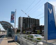
7 CHAPTER 5 Contact Information and Reference Documents Contact Information...52 The Regional Municipality of York York Region - Development Engineering Section York Region - Roads and Traffic Operations York Region - Transportation Planning Section York Region - Development Planning Section Local Municipalities Other Agencies Relevant Documents/Websites...54 A graphic rendering of future Vaughan Metropolitan Centre, City of Vaughan VI

8 CHAPTER 1 Transportation Mobility Plan Process and Requirements
9 1.1 Transportation planning in York Region Many of the communities within York Region and the Greater Toronto Area were planned around the use of automobiles. This traditional transportation planning practice has resulted in traffic congestion and places tremendous pressures on existing transportation systems as communities continue to grow and become more urbanized. As construction, maintenance and property costs continue to rise rapidly, it is more difficult to build and maintain new transportation infrastructure to support growth. Today, the Region s approach to transportation planning is guided through policies in the Regional Official Plan (2010) and the recommendations in the Transportation Master Plan. York Region policies and practices include infrastructure and strategies to increase walking, cycling and transit mode share to reduce single occupancy automobile trips. 1.2 Transportation policies in the Regional Official Plan The Regional Official Plan (2010), as amended, directs the vision of city building, maintaining a dynamic economy, and providing integrated and responsive human services in a sustainable manner that enhances and protects the Regional Greenlands System. Policies of Regional Council aim to build more sustainable communities by ensuring communities are designed to: Prioritize pedestrians and cyclists Reduce single occupancy automobile use Support public transit and increase non-auto mode share While a sample of transportation and transit-related policies have been referenced in this document, the policies of the Regional Official Plan must be considered together with other transportation policies to determine conformity. Some of the notable policies in the Regional Official Plan related to transportation planning requirements include: That communities be designed to ensure walkability through interconnected and accessible mobility systems. These systems will give priority to pedestrian movement and transit use, provide pedestrian and cycling facilities, and implement the York Region Pedestrian and Cycling Master Plan That mobility plans shall be completed to ensure that: a. communities are designed to have interconnected and accessible mobility systems, with a priority on pedestrian movement, and on transit use and access b. communities are designed to include a system of pedestrian and bicycle paths linking the community internally and externally to other areas, and providing access to the transit system c. a transit plan is completed in consultation with York Region Transit, which identifies transit routes and corridors, co-ordinates transit with land use patterns and ensures the early integration of transit into the community d. the distance to a transit stop in the Urban Area is within 500 metres of 90 per cent of residents, and within 200 metres of 50 per cent of residents e. all schools and community centres shall be integrated into the community mobility system and provide the ability to walk, cycle, transit and carpool to these locations f. the street network includes continuous collector streets that run both northsouth and east-west and/or a grid system of streets linked to the Regional Street network g. new community areas are designed to meet the York Region Transit-Oriented Development Guidelines 2


10 h. planned rapid transit corridors, and/ or transit terminals that connect to a rapid transit corridor, are included in the community i. parking standards, consistent with policy , encourage and support transit use and include reduced minimum and maximum parking standards j. trip-reduction strategies consistent with the policies of Section 7.1 are promoted To restrict vehicle access from developments adjacent to Regional streets to maximize the efficiency of the Regional street system through suitable local street access, shared driveways and interconnected properties. Exceptions may be made to this policy in Regional Centres and Corridors and mainstreets To require local municipalities to plan and implement, including land takings necessary for, continuous collector streets in both east-west and north-south directions in each concession block, in all new urban developments, including new community areas. 1.3 Transportation policies in local municipal Official Plans Local municipal Official Plans contain policies and guiding principles for local interests and requirements; however, as required by the Ontario Planning Act, local Municipal Official Plans must conform with the Regional Official Plan. As such, both the local Municipal and Regional Official Plans share similar objectives and visions. 1.4 Development review process in York Region The Development Review process within York Region follows the One-Window approach for providing Regional input, review, decision-making and approval. This approach streamlines and coordinates input across all Regional Departments and Branches, including: Corporate Services with Community Planning and Development Services Branch Environmental Services Transportation Services with York Region Transit and York Region Rapid Transit Corporation Figure 1 below illustrates the approval process hierarchy in York Region. Figure 1 Development Approval Process Hierarchy 3
 and secondary plans.")
.")
11 The Region is the approval authority for applications to amend the Regional Official Plan and amendments to local municipal Official Plans (unless the local Official Plan Amendments are exempted from Regional approval) and secondary plans. The Region is a commenting agency to the local municipalities on site plans, subdivision plans, condominium applications, zoning amendments, consents and minor and variance applications (the latter three only related to roads issues). Regional staff also assist the local municipalities by participating in various technical and advisory committees for strategic land use studies (secondary plans), corridor studies and Environmental Assessments. As such, there is strong coordination between Regional staff and municipal staff on the assumptions and methodologies. Under the current practice, the local municipalities in York Region are the approval authorities for subdivision plans submitted on or after March 28, The Region provides the local municipalities with conditions of draft plan approval, and a letter from the Region is required confirming the conditions have been met at the final approval stage. Some conditions, such as the requirement for a transportation impact study and transportation demand management (TDM) plan, are also coordinated between the Region and the local municipalities through pre-consultation, Development Review Committees or other specific meetings. The Region has designated Community Planning and Development Services as a one-window contact for all development applications: Official Plan Amendment (OPA) - (local municipality and York Region Secondary Plan Area Re-zoning (ZBA) Subdivision and Condominium Draft Plans Site Plans Other (consent/minor variance) Figure 2 illustrates the coordinated Regional transportation comments and conditions on development applications. Figure 2 Coordinated Regional Transportation Comments/Conditions Flow Chart 4
12 1.5 What is a Transportation Mobility Plan and why is it required? A Transportation Mobility Plan is a combination of multimodal plans along with traditional traffic impact analyses. A Transportation Mobility Plan is required to meet the objectives and requirements in the Regional Official Plan (2010) and nine Municipal Official Plans. The Transportation Mobility Plan Guidelines are the implementation tools required to implement the policies and requirements in the Regional Official Plan and Transportation Master Plan. These Transportation Mobility Plan Guidelines build upon three documents to provide greater clarity and detail on appropriate data sources and methods related to active transportation and transit: New Communities Guidelines (2013) Transit Oriented Development Guidelines (September 2006) Access Guideline for Regional Roads The Guideline purposes are to: Update the Transportation Impact Study Guidelines for Development Applications (August 2007) Provide guidance to transportation specialists in undertaking a Transportation Mobility Plan or Transportation Study in support of development applications to conform with requirements of the Regional Official Plan and Transportation Master Plan Become a reference document for Regional and local municipal technical staff in reviewing Transportation Mobility Plan studies Since the Transportation Mobility Plan requirements include multimodal analysis, the capacity and operation of other modes of transportation, including automobiles, transit, walking and cycling, must be evaluated in the same way as the auto mode in order to identify physical mitigation measures and programs/strategies to manage congestion, and to accommodate the proposed development. The following details must be documented in a Transportation Mobility Plan: 1. Existing and future performance analysis for each mode 2. Existing and future levels of service and deficiencies for each mode 3. A recommended list of mitigation measures/ programs to address any deficiencies identified in 1. and 2. above 4. A detailed implementation plan for each mode based on the recommendations identified 5. Functional designs of the proposed improvements 6. Illustrated compliance with the existing Regional and Local Municipal active transportation plans 7. Transportation Demand Management plan and implementation strategy The existing and future levels of service for all four modes of transportation are to be summarized in a table format for comparison purposes. The table is to also include information such as the improvements considered to address deficiencies related to all four modes of transportation. If tabulating improvements is not possible or too complex, a brief description of the improvements should be included in the report. 1.6 When is a Transportation Mobility Plan Study required? A Transportation Mobility Plan Study is required when the proposed development generates 100 or more person trips. This Study is prepared in support of the Official Plan Amendment, Secondary Plan, Block Plan, Zoning Bylaw Amendment, draft plan of subdivision and site plan applications. If the proposed development generates fewer than 100 person trips, a Transportation Mobility Plan Study may still be required under the direction of and in consultation with Regional and local municipal staff. It would assess the impact of the proposed access locations and operations, as well as address any localized issues related to safety or operational concerns for other modes of transportation. A Transportation Demand Management Plan is required as a component of the Transportation Mobility Plan Study. 5
13 It is recommended that the applicant or transportation specialist contact the Region and local municipality for the proposed scope of work. 1.7 Transportation Mobility Plan and land use planning The key elements of the Regional Official Plan related to transportation planning include: City building, focusing on Regional Centres and Corridors and including innovation in urban design and green building New community areas, designed to a higher standard that includes requirements for sustainable buildings, water and energy management, public spaces, mixeduse, compact development, and urban design York Region Transportation Master Plan (2016) Enhanced mobility systems using a people and transit first approach to connect land use and transportation planning The objectives of the Regional Transportation Master Plan include: Create a world class transit system Develop a road network fit for the future Integrate active transportation in urban areas Maximize the potential of employment areas Make the last mile work The Regional Official Plan and Transportation Master Plan have a common goal to building complete communities. Complete communities are places where people can live, work, play and learn without the need to travel long distances. Integrating a Transportation Mobility Plan and land use planning will offer communities with different travel choices including; convenient access to transit, walking, cycling or carpooling, which supports the economy with meaningful employment and opportunities for local businesses to thrive. The applicant s transportation specialists, planners and architects are encouraged to work together to integrate land use and a transportation mobility plan to achieve the objectives of a complete community. To achieve this objective, the following transportation principles are applicable for all types of development applications including Official Plan Amendments, secondary and development area plans, draft plans of subdivisions, site plans and re-zoning applications: Transportation capacity will be assessed on the basis of congestion management linking improvements to all transportation modes (auto, bike, walk, transit and carpooling) Travel demand impacts of the proposed development will be mitigated with infrastructure and program improvements to shift a higher proportion of travel demand to transit and other non-auto modes and not increasing traffic congestion on adjacent Regional roads during peak periods Interconnections with and between adjacent developments for auto and non-auto modes are required, in consultation with the respective local municipalities A connected finer grid street network will be planned and implemented through the development approvals and phasing process, including the identification of additional street, pedestrian, cycling and transit linkages, in consultation with respective local municipalities Where necessary, triggers for each phase of development will include improvements and performance-based standards that are tied to road, transit and other sustainable transportation modes Parking supply and design will reflect and support the transit-priority policies through secondary plan area studies, and shall reflect parking rates consistent with mode share assumptions Increase sustainable transportation modal split including transit through initiatives such as Transportation Demand Management measures, strategies and programs, including cycling, walking, transit use incentives and ride-matching programs for residents/employees, will be required to mitigate the travel demand impacts of each phase of development A proponent should be identified for every recommendation in the Transportation Mobility Plan 6
14 1.8 Transportation Mobility Plan process The Transportation Mobility Plan process is illustrated in Figure 3 and further explained in Chapter Transportation Mobility Plan requirements for types of development applications A Transportation Mobility Plan is required for all development applications that generate 100 or more person trips, including Official Plan Amendments, secondary and development area plans, draft plans of subdivisions, site plans and re-zoning applications. It is recommended that prior to starting a Transportation Mobility Plan study, the transportation specialists contact Regional and local municipal staff to discuss the scope of work and requirements Transportation Mobility Plan for Official Plan Amendment An Official Plan Amendment application is required when policies and/or land use designations in the Regional Official Plan or local municipal Official Plans are changed. An OPA is the first application to determine the appropriateness of the change in land uses or policies. These changes will shape the development pattern and may require substantial transportation infrastructure improvements to accommodate the proposed land uses. The applicant s engineers, planners and architects must work together to achieve the key transportation principles identified in Section 1.7. The main objectives and requirements of a Transportation Mobility Plan to support an OPA application are: To provide sufficient details about the impact of the proposed land use or policy changes on the existing transportation system for all modes of transportation To identify what other transportation infrastructure improvements for all modes of transportation are required above and beyond those identified in the Regional and local Municipal Transportation Master Plans or the Region s 10-Year Roads and Transit Capital Construction Program, as well as municipal construction programs To identify high level Transportation Demand Management plans, measures and initiatives to achieve the non-auto modal split and to reduce single-occupant-vehicles. This level of analysis is similar to the secondary plan/block plan requirement To identify a realistic implementation plan in order to achieve complete community building objectives as required in the Regional and local municipal Official Plans. The requirements above will be reflected in the Transportation Mobility Plan report and Official Plan Amendment policies and will act as a framework to guide the secondary plans and block plans, as well as the final stage of the development such as draft plans of subdivision and site plans Transportation Mobility Plan for secondary plan and block plan The secondary plan implements the objectives, policies and land use designations of the Regional and local Municipal Official Plans at the community and neighbourhood scale. Secondary plans provide a detailed policy framework and direction for a specific geographic area on topics such as land use, infrastructure, transportation, environment and urban design. A Secondary plan is one of the most important types of applications for the approval and reviewing agencies because it will designate the appropriate location for each type of land use and how the community will be built around it. The applicant s engineers, planners and architects must work together to achieve the key transportation principles identified in Section 1.7. The main objectives and requirements of a Transportation Mobility Plan to support a secondary plan application are: To provide sufficient details about the impact of the proposed land use or policy changes on the existing transportation system for all modes of transportation 7
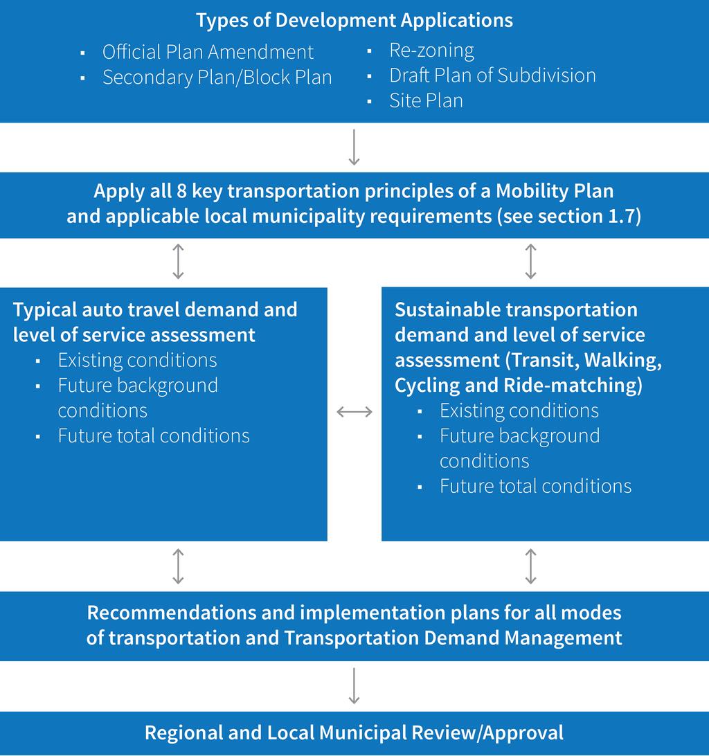
15 Figure 3 Transportation Mobility Plan Process 8
16 To identify a more defined external and internal transportation network to accommodate all modes of transportation. This includes finer grid road network, active transportation network and detailed transit network in consultation with York Region Transit. The recommended transportation network must meet the objectives and requirements of the Regional and local municipal Official Plans, Transportation Master Plans, Region s New Communities Guidelines and the local municipal guidelines and requirements To identify other transportation infrastructure improvements and missing links for all modes of transportation required above and beyond those identified in the Regional and local Municipal Transportation Master Plans or the Region s 10-Year Roads and Transit Capital Construction Programs, as well as local municipal construction programs To identify development phasing plans based on the planned and scheduled proposed transportation infrastructure improvements To identify high level Transportation Demand Management plans, measures and initiatives to achieve the non-auto modal split and to reduce single-occupant-vehicles. This level of analysis is similar to the OPA requirement To identify a detailed implementation plan in order to achieve complete community building objectives These requirements will be reflected in the Transportation Mobility Plan report, Secondary Plan report and schedules to guide the draft plans of subdivision and site plans Transportation Mobility Plan for site plan and draft plan of subdivision As indicated in Figure 1, site plans and draft plans of subdivision are the last stage of the development application process where the development policies, principles and requirements of the OPA and secondary plan will be implemented. The applicant s engineers, planners and architects must work together to achieve the key transportation principles identified in Section 1.7. The main objectives and requirements of a Transportation Mobility Plan to support a site plan or draft plan of subdivision application are: To provide detailed impacts of the proposed development on the existing transportation system for all modes of transportation To identify a defined external and internal transportation network to accommodate all modes of transportation. This includes finer grid road network, active transportation network and detailed transit network in consultation with York Region Transit and municipalities. The recommended transportation network must meet the objectives and requirements of the Regional and local Municipal Official Plans, Transportation Master Plans, Region s New Communities Guidelines and municipal guidelines and requirements To apply the proposed development phasing plans based on the planned and scheduled proposed transportation infrastructure improvements identified in the secondary plan process To identify a site specific implementation plan for other transportation infrastructure improvements for all modes of transportation required as identified in the secondary plan To identify appropriate site access arrangements based on the Region s Access Guidelines and respective municipality s guidelines that will accommodate all modes of transportation To identify site specific and detailed Transportation Demand Management plans, measures and initiatives to achieve the non-auto modal split and to reduce single-occupant-vehicles in consultation with Regional and municipal staff. A TDM checklist is provided in Chapter 3 of this report To identify site specific implementation plans in order to achieve complete community building objectives To meet the appropriate local municipal bylaws on parking, loading, urban design and internal site circulation requirements The requirements above will be reflected in the Transportation Mobility Plan report. 9
17 1.10 York Region s multimodal level of service evaluation approach York Region has developed its preferred multimodal level of service evaluation approach to address the performance requirements for each mode of transportation. These requirements are based on policies from the Region s 2016 Official Plan and recommendations from the 2016 Transportation Master Plan. Other guidelines such as the Context Sensitive Solutions Design for Regional Roads were also consulted and included in the evaluation approach. The level of analysis and detail within a Transportation Mobility Plan will depend on the scale and location of the development and purpose of the study. Area wide studies for secondary plans and block plans will require an assessment of road, active transportation and transit network implications along with impacts at key intersections while subdivision plans and development site plans may concentrate more on immediate impacts of adjacent intersection operations and access arrangements. The integrated multimodal approach analysis provides a snapshot of the levels of service for the entire corridor as a whole, which fits into the Transportation Mobility Plan context. It provides agencies with a better tool to understand the constraints and limitations to find innovative solutions beyond the traditional practices that address only traffic operational issues. The Regional and local Municipal Official Plans and Transportation Master Plans also contain policies and guidelines which require new community and intensification areas to accommodate all modes of transportation. These requirements should be included in, but not limited to, transportation studies undertaken for new communities, intensification areas and infill developments. service for each mode should not be combined into one overall level of service for the street since the trip purpose, length and expectations for each mode are different. Each travel mode also has different performance indicators. These indicators are based on the policies, localized experience and professional judgment related to the built-form of the area. However, all modes should be reviewed together to ensure the interconnection and interaction between them are documented. The recommended mitigation measures and improvements should complement each other in a holistic manner. Table 1 on page 11 summarizes the typical quantitative and qualitative indicators for each travel mode that are applicable to most of the Regional corridors. These indicators should be evaluated and included in the Transportation Mobility Plan. Target levels of service have been provided for each mode. Where existing or future target levels of service have not been met, it is expected that the transportation specialist will recommend reasonable mitigation measures and improvements to achieve the target level of service. All modes should be reviewed together to ensure the interconnection and interaction between them are documented. The recommended mitigation measures and improvements should complement each other in a holistic manner Travel mode performance and indicators The Region requires the transportation specialist to provide both quantitative and qualitative evaluation approaches to assess each mode of transportation. The quantitative methods are used as a tool to evaluate urban street operations from an integrated multimodal performance perspective. The level of service provided for each travel mode is separately evaluated. The transportation specialist should determine the relative importance of each mode s level of service based on the purpose and objective of the analysis. The level of 10
18 Table 1 - Travel Mode Indicators Travel Modes Automobile Pedestrian Bicycle Transit Indicators Intersection level of service (delay seconds/vehicle) Volume-to-capacity ratio (v/c) Queuing Storage capacity/auxiliary turning lanes Potential conflicts/weaving/safety issues Facility and connectivity Designs, gaps and missing links Average crossing delay at signalized intersections Average crosswalk length/crossing distance Qualitative measure of pedestrian experience Traffic volume Traffic speeds Buffer between sidewalk and traffic lanes Bike lane facility and connectivity Designs, gaps and missing links Access to bikeways (distance and time) Potential barriers Access to transit stops, stations or transfer points Transit service frequency and boarding volumes Transit vehicle performance at the intersection approach Automobile performance evaluation requirement Capacity and Level of Service (LOS) analyses are conducted for interrupted-flow conditions in the form of signalized and unsignalized intersection operations assessment for motorists. There are two criteria required for the automobile mode level of service performance: vehicle delay and volume-tocapacity ratio. Both of these criteria are to be completed and included in the Transportation Mobility Plan Study. It should be noted that signalized intersections with high left turn and right turn traffic volumes, long exclusive right turn lanes, channelized right turn and significant width will have negative impacts on pedestrian and bicycle modes. As such, when conducting intersection capacity analysis, transportation specialists should consider and evaluate the pedestrian and bicycle modes to provide appropriate mitigation measures and improvements to address these impacts. Automobile LOS and V/C Target: D (0.85) or better for urban area and LOS C(0.70) or better for rural area 11
19 Table 2 summarizes the level of service evaluation requirement for the automobile mode. Table 2 - Automobile Level of Service Criteria (Signalized Intersection) Level of Service Delay (seconds/veh) V/C A 10 0 to 0.60 B > to 0.70 C > to 0.80 D > to 0.90 E > to 1.00 F >80 >1.00 Table 3 illustrates an example of automobile level of service criteria for signalized intersections. Table 3 - Automobile Level of Service Summary Intersection Main Street/ Street A Main Street/ Street B Main Street/ Street C Note: Existing Conditions LOS (delay in seconds) Critical Movement 1 [v/c ratio] C (22) SB T: [0.90] NB L: [0.95] B (15) No Critical Movement A (3) No Critical Movement Future Conditions LOS (delay in seconds) Critical Movement 1 [v/c ratio] E (58) SB T: [1.11] NB L: [0.96] C (23) No Critical Movement E (70) SB T: [1.16] NB L: [0.98] SB T = Southbound Through NB L = Northbound Left Transit performance evaluation requirement When performing the intersection capacity analysis, transportation specialists should also consider transit vehicles, especially when transit vehicles share the same facilities as automobiles. The intersection capacity analysis should consider the frequency of transit vehicle stops and whether the intersection would be able to accommodate the scheduled transit service frequency. There are three required criteria for the transit mode level of service performance: 1) access to the transit stops, 2) transit headways and 3) transit vehicle performance at the intersection approach. Where there are more than one intersection within the study area, the most critical intersection approach should be identified and LOS indicated for each intersection. All of these criteria should be completed and included in the Transportation Mobility Plan Study. Transit LOS Target: C or better for Access to Transit Stops and Transit Headways. LOS D or better for Intersection Approach. It should be noted that all detailed analyses or supporting information related to the level of service calculations or observations for automobile mode should be included in the appendices. 12
20 Table 4 summarizes the level of service criteria for the transit mode. Table 4 - Transit Level of Service Criteria Level of Service A B C D E F Definitions Access to Transit Stops 90% within 200 m 90% within 500m and 70% within % within 500m and 50% within 200m 100% within 600m 100% within 800m 100% >800m Transit Headways 5 minutes >5-10 minutes >10-15 minutes >15-20 minutes >20-30 minutes >30 minutes Intersection Approach (transit or curb lanes) Delay (seconds/ veh) V/C 10 0 to 0.60 > to 0.70 > to 0.80 > to 0.90 > to 1.00 >80 >1.00 Access: development s potential transit riders straight line walking distance to transit stops Stops: bus stops, rapid transit stations, subway stations, RER/GO Train/Bus stations Transit headway: time interval between transit vehicles for a transit corridor Intersection Approach: critical lane group or curb lane with transit vehicles approaching an intersection Transit or curb lanes: general purpose lane or curb lane where buses will operate Table 5 illustrates the example of transit level of service. Table 5 - Transit Level of Service Summary Transit Stop Location Main Street/ Street A Main Street/ Street B Direction Access to Transit Stops Transit Headways Intersection Approach (transit or curb lanes) LOS LOS LOS Eastbound C D D Westbound C D D Northbound C C C Southbound C C C Eastbound B D D Northbound B C C Southbound B C C All detailed analyses or supporting information related to the level of service calculations or observations for transit mode should be included in the appendices Pedestrian performance evaluation requirement Walking can be a mode of choice for short trips such as going to transit stations, schools, running errands, and going to work. As pedestrians are more vulnerable than motorists, facilities and measures should be provided to separate pedestrians from vehicular traffic. Traffic control devices such as pedestrian signals, pedestrian only signals, zebra cross-walks, sufficient illumination, proper sidewalks and designated waiting areas can improve pedestrian safety. In general, 1.2 metres per second walking speed can be used to calculate pedestrian clearance time at the signalized intersections. However, in school or senior resident areas, 1.0 metres per second walking speed should be used to calculate pedestrian clearance time at the signalized intersections. There are two required criteria for the pedestrian mode level of service performance, at the segment (between two or more intersections) and at intersection (signalized or unsignalized) areas. Both of these criteria should be completed and included in the Transportation Mobility Plan Study. It should be noted that signalized intersections with 13
21 high left turn and right turn traffic volumes, channelized right turn and wide intersection will have negative impacts on pedestrian mode. As such, when conducting intersection capacity analysis, transportation specialists should consider and evaluate the pedestrian mode to provide appropriate mitigation measures and improvements to address these impacts. Table 6 summarizes the level of service criteria for pedestrian mode. Pedestrian LOS Target: C or better for these LOS Categories Table 6 - Pedestrian Level of Service Criteria Level of Service Segment Intersection A B C D E F Definitions 2.0 m sidewalk with minimum 3.5 m buffer including planting and edge zone; or 3.0 m multi-use path 1.5 m sidewalk with minimum 1.0 m buffer including edge zone; or <3.0 m multi-use path 1.5 m curb-faced sidewalk (no buffer) <1.5 m sidewalk Paved shoulder or no sidewalk provision No sidewalk provision Buffer: green or landscaped space separating the sidewalk and pavement street curb. Curb-faced: the sidewalk is located adjacent to the pavement and street curb. Delineated cross-walk: painted or special pavement to facilitate pedestrians. 2.0 m sidewalk with minimum 3.5 m buffer including planting and edge zone; or 3.0 m multi-use path Pedestrian signal head with sufficient pedestrian clearance time Clearly delineated cross-walk 1.5 m sidewalk with minimum 1.0 m buffer including edge zone; or <3.0 m multi-use path Pedestrian signal head with sufficient pedestrian clearance time Clearly delineated cross-walk 1.5 m curb-faced sidewalk (no buffer) Pedestrian signal head with sufficient pedestrian clearance time Clearly delineated cross-walk <1.5 m sidewalk Pedestrian signal head sufficient pedestrian clearance time No clearly delineated cross-walk Paved shoulder or no sidewalk provision No pedestrian signal head No clearly delineated cross-walk No sidewalk provision No pedestrian signal head Not clearly delineated cross-walk 14

22 Table 7 illustrates an example of pedestrian level of service. Table 7 - Pedestrian Level of Service Summary Intersection Main Street/ Street A Main Street/ Street B Direction Segment Intersection Description LOS LOS Eastbound Street A C B Westbound Street A B A Northbound Main Street C B Southbound Main Street B B Eastbound Street B A A Westbound Street B B B Northbound Main Street C B Southbound Main Street C B It should be noted that all detailed analyses or supporting information related to the level of service calculations or observations for pedestrian mode should be included in the appendices. Figure 4 illustrates an example of level of service assessment for pedestrian and bicycle modes. Figure 4 - Example of Level of Service Assessment Bicycle performance evaluation requirement Cycling can also be a mode of choice for short to medium distance trips. A bicycle is defined as a vehicle under the Ontario Highway Traffic Act and cyclists must abide by the rules of the road. However, cyclists are more vulnerable than motorists so safety measures should be provided as much as possible. Bicycle signals, dedicated or separated cycling facilities, shared facilities, cross-rides and other pavement markings can improve cycling safety. There are two required criteria for the bicycle mode level of service performance, at the segment (between two or more intersections) and at intersection (signalized or unsignalized) areas. Both of these criteria should be completed and included in the Transportation Mobility Plan Study. Signalized intersections with high left turn and right turn traffic volumes, long exclusive right turn lanes, channelized right turn and wide intersection will have negative impacts on bicycle mode. As such, when conducting intersection capacity analysis, transportation specialists should consider and evaluate the bicycle mode to provide appropriate mitigation measures and improvements to address these impacts. Bicycle LOS Target: C or better for these LOS Categories 15
23 Table 8 summarizes the level of service criteria for bicycle mode. Table 8 - Bicycle Level of Service Criteria Level of Service Segment Intersection A B C D E Definitions Separated cycling facilities (e.g. cycle tracks, multi-use path) 1.8 m dedicated cycling facilities (e.g. bicycle lanes with and without buffer) <1.8 m dedicated cycling facilities with no buffer 1.5 m bicycle lane with no buffer Shared facilities (e.g. signed routes, sharrows or paved shoulder with minimum 1.2 m in constrained area) Separated cycling facilities Bicycle box or clearly delineated bicycle treatment or bicycle signal head >1.8 m dedicated cycling facilities (e.g. bicycle lanes with and without buffer), Bicycle box, clearly delineated bicycle treatment or bicycle signal head <1.8 m dedicated cycling facilities with no buffer, Bicycle box, clearly delineated bicycle treatment or bicycle signal head 1.5 m bicycle lane and no buffer Bicycle treatment Shared facilities (e.g. signed routes, sharrows or paved shoulder with minimum 1.2 m in constrained area) No clearly delineated bicycle treatment F No bicycle provision No bicycle provision Shared: Shared facilities include roadways or streets where cyclists and motorists use the same road space. Types of shared facilities include signed routes, bicycle boulevards or shared lanes ( sharrows ). Since cyclists and motorists share the same space, these facilities are appropriate on streets with low traffic volumes and/or low speeds. Dedicated: Designated or dedicated facilities are those that provide space on the road intended for use by cyclists only. They are generally adjacent to motor vehicle lanes and defined by pavement markings. In urban areas, dedicated facilities typically include bike lanes and buffered bike lanes while paved shoulders provide dedicated space on rural roads. Separated: Separated bikeways are separated from traffic by more than just a painted line. Separation may consist of bollards or delineators, mountable or barrier curbs, planters, concrete medians, etc. Types of separated facilities can include cycle tracks, raised bike lanes, or multi-use trails. These facilities improve safety and comfort for cyclists along higher-speed, busy roadways. Buffer: a painted area or physical barrier that separates the bicycle lane from the adjacent traffic lane. Bicycle box: A bike box is used at intersections with dedicated bike lanes or a cycle track to designate a space for cyclists to wait at a red light or to assist cyclists in making left turns. Cyclists stop in front of motorists and can proceed through the intersection first when the light turns green. Paved shoulder: Paved shoulders are located next to the travelled portion of the roadway and used to accommodate cyclists on rural roads. 16
24 Table 9 illustrates the example of bicycle level of service. Table 9 - Bicycle Level of Service Summary Intersection Main Street/ Street A Main Street/ Street B Direction Segment Intersection Description LOS LOS Eastbound Street A C B Westbound Street A B A Northbound Main Street C B Southbound Main Street B B Eastbound Street B A A Westbound Street B B B Northbound Main Street C B Southbound Main Street C B It should be noted that all detailed analyses or supporting information related to the level of service calculations or observations for bicycle mode should be included in the appendices Alternate multimodal level of service evaluation methodologies Recognizing that the multimodal level of service analysis methods are new, the Region will accept both the Region s multimodal level of service analysis approach, or quantitative methods that are recognized as the industry best practices including those found in the latest edition of the Highway Capacity Manual (HCM2010), Pedestrian Exposure to Traffic at Signalized Intersections (PETSI) or other published approaches that are appropriate to the York Region context. However, all referenced methodologies should be consulted and examined carefully for appropriateness. While engineering and professional judgment are required to interpret the results, all assumptions must be clearly documented. As illustrated in Figure 3, there are potential interactions between the automobile mode and non-auto modes of transportation. As automobile volume or speed increases, level of service for other modes may decrease due to potential conflict and other safety issues. If bicycle, pedestrian or transit flows increase, the level of service for the automobile traffic stream may decrease. As such, when preparing analysis and recommendations, the analyst must keep in mind that not all factors can be improved as level of service for one mode may affect the other modes. Typically, a combined level of service is not required or recommended Software and input parameters For intersection operational analysis, there are several tools and methods accepted, including: Highway Capacity Software based on the Highway Capacity Manual (HCM) Synchro software using HCM outputs InterCalc software based on the Canadian Capacity Guide for Signalized Intersections Micro-simulation software such as Vissim, Paramics and Sim-Traffic Other specialized roundabout analysis software (Rodel, Sidra, Arcady, etc ) Other proprietary tools based on the Highway Capacity Manual and Canadian Capacity Guide for Signalized Intersections can be applied subject to approval by Regional and local municipal staff. Transportation specialists using proprietary software other than those mentioned above should consult with the Regional and respective local municipal staff prior to its application in the Transportation Mobility Plan. It is the Region s preference that transportation specialists apply the latest version of the analytics software, where applicable. All input parameters and assumptions should be clearly documented. The transportation specialist should confirm that 17
25 inputs and assumptions comply with the Region s standards and current practices. The following are some examples of input parameters for conducting intersection capacity analysis: A default ideal saturation flow of 2,000 vehicles/hour/ lane (vphpl) may be used for all movements. The Region will not accept any value above 2,000 vphpl unless it is approved by the Region and/or supported by field measurements for the existing conditions It should be noted that the saturation flow for local municipal roads may be less than 2,000 vehicles/hour/ lane. As such, the transportation specialist should consult with the respective local municipality to obtain the appropriate saturation flow rates. Peak hour factors should be based on existing traffic counts. The future proposed intersection peak hour factors should be based on adjacent existing intersections Traffic signal cycle lengths, signal phasing and timing plans should be obtained from the Region/local municipality Lost Time Adjustment default is zero. Reasonable adjustment values of less than three seconds are permitted for critical movements. However, the Region may request field studies to support the adjustments Lane utilization for HOV lanes should not be more than 50% capacity of the adjacent general purpose lanes It should be noted that these parameters may change over time. As such, the transportation specialist conducting the Transportation Mobility Plan should consult with Regional and respective local municipal staff to confirm these parameters prior to the commencement of the study Transportation Mobility Plan process confirmation and checklists As illustrated in Figure 3, the Transportation Mobility Plan process is somewhat similar to a typical or traditional transportation study that supports the development application. Some notable differences are: The Transportation Mobility Plan requires the assessment of all four major modes of transportation. This approach is a requirement to conform to the Regional Official Plan policies The Transportation Mobility Plan also requires the following assessment for each horizon year Mitigating auto demand Identify/exhaust possible physical transportation improvements to address the development impacts without significantly impacting other modes Recommend a list of physical improvements Promoting non-auto demand Identify and recommend active transportation requirements Identify and recommend transit stops, routes and network requirements for each horizon year Identify and recommend infrastructures and strategies to increase walking, cycling and transit mode share for each horizon year considered A detailed implementation plan and functional design Where unique land use or situations warrant, the Region encourages transportation specialists to use relevant experience/first principles or methodologies accepted by the industry to estimate multimodal trip generation and multimodal performance analysis for auto, walking, cycling and transit trips. In all cases, the methods used should be clearly documented in the study. To better assist transportation specialists in preparing a quality Transportation Mobility Plan report, the following checklist provides a step-by-step guide to fulfill the Region s requirements. The information contained in Table 10 is explained in more detail in Chapter 3. Regional and respective local municipal staff will be using the information contained in Table 10 as a checklist for reviewing the Transportation Mobility Plan for completeness. If required elements are not included in the Transportation Mobility Plan without a detailed explanation in the document, the submitted Transportation Mobility Plan may be considered incomplete and staff may return it to the author for further revision. 18
26 Table 10 York Region Transportation Mobility Plan Checklist 1 Report Elements for Various Types of Development Applications Title page including company name and project title Have these requirements been included in the report? Chapter 2 Reference Official Plan Secondary Plan Major Area Plans Rezoning Draft Plan of Sub- division Site Plans Cover letter or signature page Table of contents Executive Summary - summarizes the assumptions and findings of the study Introduction Summary of transportation planning policies and how they have been addressed Summary of consultation with agencies Study area Existing transportation system characteristics and performance Peak periods of analysis Input parameters and assumptions Existing multimodal data and performance analysis Existing automobile mode performance Existing pedestrian mode performance Existing bicycle mode performance Existing transit mode performance Horizon years analysis to be consistent with the requirement in Figure 5, Chapter 2 of the guidelines Provide a list and brief description of each background development in the study area Background development multimodal trip generation Background development multimodal trip distribution and assignment Background multimodal growth rates
27 22 Report Elements for Various Types of Development Applications Transportation demand forecasting model (used in growth area where appropriate) Have these requirements been included in the report? Chapter 2 Reference Official Plan Secondary Plan Major Area Plans Rezoning Draft Plan of Sub- division Site Plans Future transportation improvement Future background multimodal volumes and performance and recommendations Site trip generation Auto site trip generation Transit site trip generation Walking and cycling site trip generation Site multimodal trip distribution and assignment Total multimodal forecast volumes and performance Automobile mode impact Mitigation measures for auto mode Transit mode impact Active transportation mode impact Transportation demand management Safety analysis Recommendations Implementation plan Conclusions 2.31 Report Submissions: If submission of a Transportation Mobility Plan Study is required, please follow the process outlined in Figure 2 and send the report to Development Planning or Development Engineering for circulation depending on the type of application. Please do not send the report to individual Regional departments. Report resubmissions should also follow this process. 20

28 CHAPTER 2 Transportation Mobility Plan Technical Guidelines 21
29 General requirements These requirements should be provided as part of a Transportation Mobility Plan study: Three hard copies of the report plus an electronic copy. In some cases, electronic copies of the analyses (i.e. Synchro files, drawings) may be requested. Pre-consultation meeting minutes and correspondence should be included in the appendices If the Transportation Mobility Plan is prepared in response to the comments provided by the Region or respective local municipality, a response matrix should be provided as part of the report to indicate how these comments are addressed A Transportation Mobility Plan study should be submitted through a normal development application submission process If a Transportation Mobility Plan study is an addendum or revised study, it can be submitted to the respective local municipality and York Region s Development Planning/Development Engineering staff Detailed requirements The following detailed requirements must be provided as part of a Transportation Mobility Plan study: 2.1 Title page The title page should include the following information: Company name Project name/title Municipal address/concession block Landowner/Applicant name Date 2.2 Cover letter or signature page The cover letter or signature page should include the following information: Company name Date Project name/title Municipal address/concession block A brief project description and purpose of the report Report revision number (if applicable) and titles/ dates of related reports Overall study conclusions/recommendations Contact information of the qualified transportation specialist Signature of the transportation specialist conducting and recommending the results of the study 2.3 Table of contents A table of contents is required for all Transportation Mobility Plan studies and should include the following information: Table of contents List of exhibits and tables List of appendices 2.4 Executive summary An executive summary is required for all Transportation Mobility Plan studies and should include the following: A summary of the proposed development: location, statistics, phasing type of development and other background information to help the reviewer understand the context of the development A summary of the study/analysis process Key findings and recommendations of the study A summary of the implementation plan for the report recommendations 22
 Proposed land use Proposed study area It is recommended that the study area be confirmed with Regional and local municipal staff before commencing data collection")
30 2.5 Introduction The introduction section should include the following: Identification of the applicant Site location Type or nature of the application (Official Plan Amendment, Rezoning, Draft Plan of Subdivision, Site Plan or others) Proposed land use Proposed study area It is recommended that the study area be confirmed with Regional and local municipal staff before commencing data collection and analyses. Relevant maps should be included to show the study area. Typically, the study area should include all local Municipal, Regional and Provincial roads, expressways, intersections, interchanges, transit services and facilities that will be affected by the proposed development. Maps or plans should be provided and illustrate: Location and extent of the proposed development Existing land use of the subject site and its adjacent lands Relevant Secondary Plan studies, approved and pending subdivisions, as well as the site plans within the study area boundaries for the subject development, assumptions should be documented in the Transportation Mobility Plan A description of the type of land uses proposed, including the size of the individual land use components expressed in units related to transportation analysis (e.g. floor area, number of residential units, population, employment, number of parking spaces, etc.). Special attention should be paid to gross vs. net floor area definitions. The following information may be included as part of the introduction: A site plan or concept drawing that shows site layout and proposed accesses Identification of any phasing schemes and schedule of implementation with associated land use statistics The expected dates of completion and full occupancy of the ultimate development and any interim phases, if known Condo construction on Davis Drive, Town of Newmarket 23
31 2.6 Summary of transportation planning policies A summary of the key Regional and respective local municipal transportation related policies in Official Plans and/or Secondary Plans specific to the development site or area should be provided. These policies will provide transportation specialists and reviewers with a better understanding of the context for the proposed development relative to a corridor, urban growth centre or other planning areas. 2.7 Summary of consultation with agencies It is recommended that the transportation specialists consult with Regional and respective local municipal staff when preparing a Transportation Mobility Plan. A summary of the pre-consultation comments provided by Regional and local municipal staff should be included in the final report appendices. Examples may include a summary of pre-consultation discussions, identification of network assumptions or identification of the study area. If applicable, copies of any formal correspondence/meeting minutes should also be included. 2.8 Study area A study area must be established prior to the data collection process. Under current practices, the study area is selected based on the impact of the vehicle and pedestrian traffic generated by the proposed development. For example, the intersections or roadways that will carry five percent or more of the site generated traffic should be included in the analysis. The Transportation Mobility Plan should include all major and minor arterial roads, collector roads, Provincial highway interchanges, intersections and transit services/stations that will be affected. Since every development is unique due to the proposed land use and strategic location, it is recommended that the transportation specialist consult with Regional and local municipal staff to establish the study area prior to starting the Transportation Mobility Plan. 2.9 Existing transportation system The existing transportation system should be summarized through either maps and/or tables, including, but not limited to: Key roads, jurisdiction, number of lanes, posted speed limits Intersection traffic controls, lane configuration, turning restrictions Railway crossings, specifically where parking facilities are provided such as GO Train stations Transit routes and service frequencies Transit stops and stations Higher order transit including transit priority lanes, high occupancy vehicle lanes and bus rapid transit networks Pedestrian facilities Cycling facilities Locations with critical horizontal and vertical grades Other traffic controls, restrictions on travel movements Heavy vehicle (truck) restrictions Adjacent and opposite driveways and other site accesses including spacing between driveways and accesses Other large scale traffic generators such as schools, parks, stadiums, shopping centres and parking facilities Other features of importance 2.10 Peak periods of analysis Time periods for analysis are critical for certain types of land use applications. The peak hours will be identified on the basis of the worst-case combination of site-generated trips plus background traffic/transit volumes across the study area. Other peak hours, such as weekday noon hour, Saturday/Sunday afternoons or Friday evenings for retail/ commercial uses, should be reviewed to see if they will result in a worst-case situation. 24
32 A noon time peak hour may have to be analyzed for developments containing food establishments, particularly fast food outlets. If the proposed development generates a significant amount of truck traffic, the analysis periods and volumes should be specified and included in the analysis. Table 11 summarizes typical requirement for time periods based on land use type. It is recommended that the analysis time periods be confirmed with Regional staff before starting the Transportation Mobility Plan. For mixed-use developments, the predominant trip generation and worst case combination should be reviewed for impact to the surrounding transportation system. Table 11 Typical Peak Periods for Analysis Land Use Type Retail, Commercial (e.g. shopping centre, restaurant, specialty store, super market) Residential (e.g. single family, townhouse, condominium, apartments, senior homes) Employment (e.g. business park, industrial park, office, warehouse) Institutional (e.g. school, church, banquet hall, entertainment centre, community centre) Centres and Corridors (mixed-use developments area) AM Peak PM Peak Weekend/ Saturday Site Specific No Yes Yes No Yes Yes No No Yes Yes No No Yes Yes Yes Yes No 2.11 Input parameters and assumptions All assumptions concerning saturation flows, peak hour factors, lost times, lane utilization, traffic signal cycle lengths, signal phasing and signal timings should be documented. The transportation specialist should confirm that assumptions are in conformance with Regional and local municipal standards and current best practices. The following are some examples for input parameters for conducting intersection capacity analysis: Saturation flows above the ideal saturation flow of 2,000 vehicles/hour/lane will not be accepted unless substantiated through surveys of existing conditions or approved by the Region It should be noted that the saturation flow for local municipal roads maybe less than 2,000 vehicles/hour/lane. As such, the transportation specialist should consultant with respective local municipalities to obtain the appropriate saturation flow rates. Peak hour factors should be guided by existing traffic counts Traffic signal cycle lengths, signal phasing and timing plans should be obtained from the Region and respective local municipality, where appropriate Lane utilization for HOV lanes should not be more than 50% capacity of the adjacent general purpose lanes It should be noted that these parameters may change over time, and the transportation specialist conducting the Transportation Mobility Study should consult with Regional and respective local municipal staff to confirm these parameters prior to starting the Transportation Mobility Plan. 25
33 2.12 Existing multimodal data and performance analysis A multimodal review of existing active transportation (walking and cycling), transit and traffic volumes for links, intersections, and major transit stops/stations in the study area should be shown on appropriate figures. Volumes should be based on the most recent traffic counts available from the Region or local municipalities. The transportation specialist should conduct additional counts where existing count data is more than two years old or where existing data appears to be anomalous or insufficient. Since 2011, the Region has supplemented the Turning Movement Count program to include both cyclists and pedestrians. Transit routes should be based on the peak points of the routes involved. It should be noted that existing ridership data can be obtained from York Region Transit. If recent counts are not available, new data must be collected to cover at a minimum the following time periods: On a typical weekday (Tuesday through Thursday) 7 a.m a.m. 11 a.m. - 2 p.m. (as applicable) 4 p.m. - 7 p.m. In addition, the transportation specialist should review any other relevant peak periods. It may include extended morning and afternoon peak periods (e.g. 7 a.m. to 10 a.m., Friday evenings or Saturday/Sunday afternoons) for certain type of developments. Existing conditions should be analyzed using existing Regional offset, signal timing and phasing parameters. These can be obtained from the Region s Traffic Signal Operations Division and the respective local municipality. Any recommendations to improve existing traffic operations should be documented and approved by Regional and respective local municipal staff, where appropriate, before being used in the analysis to reference the Existing scenario. All modes should be reviewed together to ensure the interconnection and interaction between them are documented. The recommended mitigation measures and improvements should complement each other in a holistic manner Existing automobile mode performance The automobile mode includes all motor vehicle traffic using a roadway. Capacity and level of service analyses are conducted for interrupted-flow conditions in the form of signalized and unsignalized intersection operation assessment for motorists. These intersections are typically located within the study boundary. In many instances, pedestrians, cyclists and transit vehicles are not included in the intersection operations analysis. This assessment is considered insufficient and does not provide a full picture of the intersection operations as a whole. When assessing the automobile mode performance, the transportation specialist should include the requirements listed in Section Both the delay and volume-to-capacity (v/c) ratios are acceptable parameters used in assessing the operational performance of an intersection for motorists. These parameters are usually translated into level of service. Delay is widely used in the Highway Capacity Manual method while the v/c ratio is the selected measure in the Canadian Capacity Guide for Signalized Intersections. These parameters should be considered in the assessment of an intersection at various levels including at the individual movement level, the approach level, and the whole intersection level. For intersection operational analysis, there are several tools and methods accepted including: Highway Capacity Software based on the Highway Capacity Manual Synchro software InterCalc software based on the Canadian Capacity Guide for Signalized Intersections Micro-simulation software such as Vissim, Paramics and Sim-Traffic Other specialized roundabout analysis software (Rodel, Sidra, Arcady) 26
34 Other proprietary tools based on the Highway Capacity Manual and Canadian Capacity Guide for Signalized Intersections can be applied subject to approval by York Region staff. Transportation specialists using proprietary software other than those mentioned above should consult with York Region staff prior to its application in the Transportation Mobility Plan. Historically, York Region has identified a v/c ratio threshold of 0.85 for critical movements and intersections in urban areas, or 0.7 in rural areas (Region s Transportation Impact Study (TIS) Guideline for Land Development Applications (August 2007). Since centres and corridors can experience greater levels of congestion, critical movement V/C ratios are not the only indicators that should be considered to address the impacts of the developments. As the Region and local municipalities experience more traffic congestion, developments within the urban area, particularly on transit priority and rapid transit corridors, the transportation specialist will need to consider alternative access arrangements for vehicular traffic including consolidation of accesses and/or right-in/rightout accesses only. Where additional capacity is required through signalization of an intersection, a signal warrant analysis should be carried out for the location and should be included in the appendices. For developments with impacts on signalized intersections with spacing at or near the minimal distance, a queuing analysis should be carried out to demonstrate that there is adequate storage length in the turning lanes and that queue spillback will not create adverse conditions. This can be demonstrated through micro-simulation modelling or analysis tools indicating the critical queue length (95 th percentile) at the intersection approaches. York Region s Access Guideline for Regional Roads (September 2007) specifies that the absolute minimum signalized intersection spacing on arterial roads is 215 metres and desirable spacing is metres. While the use of micro-simulation is considered appropriate for detailed operational analysis including intersection capacity, queuing, weaving and other access implications, the application of macro-scopic and meso-scopic simulation can also be used to assess subareas. Regional and respective local municipal staff should be consulted on the appropriateness of the tools prior to its application Existing pedestrian mode performance From a transportation planning perspective, the 2016 York Region Transportation Master Plan provides guidance connecting and integrating pedestrian facilities between local municipalities within York Region, and surrounding municipalities to help create a seamless and comprehensive pedestrian network. From the traffic engineering perspective, the Region and local municipalities are undertaking a comprehensive design guideline. This guideline will be available online in 2017 at york.ca. When assessing the pedestrian mode performance, transportation specialists should include the key indicators for the pedestrian mode as outlined in Table 1, Chapter 1. The Transportation Mobility Plan should provide the following analysis: Assessment of existing facilities and connectivity Identify substandard designs, substandard operations, gaps and missing links Assessment of average crossing delay at signalized intersections Assessment of average crosswalk length/crossing distance Qualitative assessment of pedestrian experience based on: Potential impact of high left and right turn traffic volumes Traffic speeds Buffer between sidewalk and traffic lanes Potential impact of channelized right turn Availability/quality of pedestrian realm A cursory review of the pedestrian collision data for intersections and mid-block locations Identify potential mitigation measures for the existing conditions, if applicable 27
35 Recognizing that these methods are new, York Region and local municipalities are willing to accept all evaluation methods that are identified by the industry as best practices, such as the new edition of the Highway Capacity Manual (HCM2010) and Ontario Traffic Manual Book 15. While engineering and professional judgment are required to interpret the results, all assumptions must be clearly documented. As indicated, the Region and local municipalities recognize that these methods are new and are willing to accept all evaluation methods that are identified by the industry as best practices such as the new edition of the Highway Capacity Manual (HCM2010) and Ontario Traffic Manual Book 18. While engineering and professional judgment are required to interpret the results, all assumptions must be clearly documented Existing bicycle mode performance From the transportation planning perspective, cycling facilities are being implemented with guidance from York Region and the municipality s Transportation Master Plans and guidelines. Bike lanes/cycle tracks are considered for urban cross-sections, while paved shoulders with adequate width for cycling are considered for rural road cross-sections. From the traffic engineering perspective, the Region and local municipalities are currently undertaking a comprehensive design guideline. Similar to walking, cycling is encouraged as a viable mode of transportation in urban areas. When assessing the bicycle mode performance, the transportation specialist should include the requirements in Section The Transportation Mobility Plan should provide the following analysis: Assessment and identification of bicycle facility crossing types including bicycle signals and cross-rides Assessment of existing facilities and connectivity Potential impact of the long right turn lane Potential impact of high left and right turn traffic volumes Identify substandard design, substandard operations, gaps and missing links for the existing conditions Assessment of accessibility to cycling facilities by distance and time Identify potential mitigation measures for the existing conditions, if applicable Origin/destination information Existing transit mode performance Besides auto mode, transit is one of the most frequently used modes of transportation in urbanized areas, especially in the southern parts of York Region. As part of the transit mode analysis, the transportation specialist should summarize the transit connections available to the potential transit riders and document the interactions between the service operators (YRT/ Viva, TTC, GO Transit and adjacent municipal transit) and any special arrangements for encouraging ridership. The surrounding transit corridors and/or transit hubs should be described in the evaluations to inform the reader of available services and providers under the existing and the future conditions. From the transit network planning perspective, York Region s Transportation Master Plan (2016) allows the Region to address future transportation needs in an efficient and integrated manner, while meeting Provincial and Regional policies that support sustainable development. York Region s Transportation Master Plan process has resulted in a set of progressive transit, roadway and policy recommendations that support the Region s vision of a more sustainable transportation system. The fast pace of growth projected in York Region between now and 2041 must be complemented by a transportation system that preserves the environment, enhances York Region s economic viability, seamlessly integrates with new and existing developments and offers more reliable travel choices for residents and employees. The Region s Transit Oriented Development Guidelines also provide recommendations about how the development should be designed to maximize the usage of public transportation. 28

36 From an engineering perspective, York Region Transit has developed design guidelines with regard to facility design. It is recommended that the transportation specialist contact York Region Transit staff to discuss the facility design. When assessing transit mode performance, the transportation specialist should include the requirements in Section The Transportation Mobility Plan should provide the following analysis with regard to the transit mode: Assessment of existing routes, ridership, connections to transit facilities and the designs of the facilities Assessment of the existing transit modal split Identify substandard designs, substandard operations, gaps and missing links to the transit facilities under the existing conditions Transit service frequency and boarding volumes Relative transit speed average transit speed/ average traffic speed (mixed traffic, HOV, dedicated transit lane) Rapid transit connectivity phase, each phase must be analyzed based on the anticipated/scheduled opening year of that phase. Five-Year Horizon Year Analysis: it is required that an assessment be carried out for the conditions five years after the last phase and/or full build-out of the proposed development. For example, if the last phase of the proposed development is anticipated to be in 2016, the 5-Year horizon analysis should be carried out for the 2021 horizon. Ten-Year Horizon Analysis: projects involving multi-phased development or projects that generate more than 1,000 peak total two-way person trips (including pass-by trips) will require an additional analysis of the conditions 10 years after the last phase or full build-out of the proposed development. For example, if the last phased or full build-out of the proposed development is anticipated to be in 2016, the ultimate horizon year is Figure 5 below illustrates typical analysis year requirements as part of a Transportation Mobility Plan. Figure 5 - Typical Analysis Years The Transportation Mobility Plan should identify potential mitigation measures for the existing conditions, if applicable. Since these requirements are new and may have some challenges, the Region will accept all evaluation methods that are recognized by the industry as best practices, subject to confirmation and approval from York Region Transit. While engineering and professional judgment are required to interpret the results, all assumptions must be clearly documented Analysis horizon years The Region requires several horizon years to be analyzed when preparing a Transportation Mobility Plan. The analysis years should include but not be limited to: Existing Analysis Year for Baseline: Transportation Mobility Plan commencement year Opening Year Analysis: opening year is the last phase and/or full build-out of construction and occupancy of the proposed development. If the proposed development consists of more than one Large multi-phase development proposals should analyze all phases of the development, as part of the development application for the first phase of development. The 29
37 Transportation Mobility Plan should be updated as the development progresses and more accurate information becomes available. If separate Transportation Mobility Plan studies are conducted for future phases then the traffic generated by previous phases of the development should not be added to background traffic, but should be considered as part of development traffic. It is recommended that analysis years should be confirmed with Regional and respective local municipal staff before starting the Transportation Mobility Plan Background developments in the study area All background developments in the study area should be identified and included in the analysis. It is recommended that this section be accompanied with a map and table summarizing the development applications within the study area to be included in the review. The transportation specialist should obtain details on these background developments from the municipal Planning Department. All the sources should be clearly documented Background development multimodal trip generation In some cases, the trip generation may be available for background developments from other transportation planning studies. However, when this information is not readily available, the methodologies outlined in Section 2.21 can be used to estimate the trip generation Background development multimodal trip distribution and assignment In some cases, the trip distribution may be available for background developments. However, when this information is not readily available, the methodologies outlined in Section 2.22 can be used to estimate the trip distribution and assignment Background multimodal growth rates Background multimodal growth rates can be estimated by the following methodologies: 1. Historical traffic counts (AADT and cordon counts) 2. Transportation demand forecasting model (strategic planning model or sub-area model) 3. Recent background transportation studies (Class Environmental Assessment, secondary plan or other transportation studies) Although each of the methodologies noted above are generally applicable to the auto mode, Method 1 (historical counts) can be applied to walking and cycling and Method 2 (modelling) can be applied to transit mode. York Region will accept any combination of the methodologies noted for all four modes of transportation considered. However, all assumptions and calculations must be clearly documented, explained and included in the final report for reference purposes Transportation Demand Forecasting Model York Region s Travel Demand Forecasting Model is a macro-scopic morning peak period model using the EMME software platform. It is a strategic transportation planning model encompassing the entire Region and surrounding Greater Toronto and Hamilton Area (GTHA) based on the 2006 Transportation Tomorrow Survey (TTS) data. The Region has a 2006 base network model, 2011, 2021, 2031 and 2041 forecast models using road and transit network data consistent with the 2016 York Region Transportation Master Plan and Regional Council adopted population and employment land use data for each of the future horizons. The Regional strategic transportation planning model only provides a high level measure of the transportation implications resulting from growth in the traffic zones. For most Transportation Mobility Plan studies, it may not be appropriate to apply the results of the model directly to traffic operational impacts without conducting a subarea analysis. A sub-area model should be considered for Secondary Plans, Block Plans and major developments that will have larger area impacts. The model may need to be calibrated and validated with the most up-to-date TTS data and current traffic counts. 30

38 Transportation specialists using the Region s forecasting model as the basis for sub-area analysis or other model refinements are required to acknowledge in writing prior to receiving the model database and agree to take full responsibility for all assumptions with respect to land use, networks, and any other input parameters. York Region s strategic transportation planning model is intended for overall Regional transportation planning and has limitations on direct application to specific area analyses. Other modelling tools are at the meso-scopic level which combines both the strategic and operational aspects of transportation modelling. It requires more intersection and network input details such as signal timing plans, turning lane configurations, lane widths, and saturation flow rates, while its output includes average speed, delays, queue lengths, turning volumes, etc. For sub-area analyses of major developments, meso-scopic modelling is considered appropriate. Operating conditions and analyses should be carried out for weekday peak hours of the adjacent street traffic for land uses, such as residential and office/commercial. Other peak periods may be appropriate depending on the land uses. For retail uses, such as shopping centres, the peak periods could be weekday afternoon and Saturday early-afternoon depending on local characteristics. Consideration should also be made about the type of vehicles to be generated by the site. Where heavy trucks are expected for deliveries during the street peak or offpeak, appropriate analysis should be carried out to address the queuing and impacts of the heavy vehicles at the intersections and access points. Particularly for secondary plans, block plans, and larger developments, the travel demands between intersections and mid-block capacities should be reviewed and assessed to determine if transportation infrastructure or additional capacities are required to accommodate the future background and total demands. Assessments could include screenline analysis by identifying traffic volumes, person trips and/or transit ridership. When physical improvements are required on Regional roads, consideration should be made with respect to Construction equipment at a residential development, Town of East Gwillimbury 31
39 York Region s policy on road widening from four lanes to six lanes. In accordance with the Regional Official Plan, all future road widening from four lanes to six lanes should only be made to accommodate transit or High-Occupancy-Vehicle lanes along with bicycle lanes within the right-of-way. With the High-Occupancy- Vehicle lanes or centre median rapid transitways, the analysis should appropriately reflect the lane configurations and effects of the transit facilities and capacity implications in the Transportation Mobility Plan documentation. The assumptions and methods used in the Transportation Mobility Plan to address the transit and High-Occupancy-Vehicle facilities should be fully documented in the report such as lane utilization adjustment factor or other methodologies Future transportation improvement The Regional Official Plan (2010) contains maps which guide the implementation of the Region s road and transit network based on the Transportation Master Plan (2016) and other sources of planning information. Road and transit network information should be reviewed and considered in the preparation of a Transportation Mobility Plan for a specific development. Depending on the study horizon and location, the available sources of transportation network planning information include: York Region s Transportation Master Plan (2016) Municipal Transportation Master Plans York Region and local Municipality s 10-Year Road Construction Program York Region Transit (YRT/Viva) - 5 Year Service Plan Local Municipal Pedestrian and Cycling Master Plans Road and Rapid Transit Project Environmental Assessment Studies Metrolinx Regional Transportation Plan ( The Big Move ) Adjacent area municipalities and other development transportation planning studies As part of the Transportation Mobility Plan, future background and total traffic conditions should examine the need for the transportation infrastructure in order to accommodate both background and site generated traffic. This review should include both planned infrastructure and additional improvements recommended through the analysis. Available transportation studies from other developments in the vicinity or adjacent municipalities should be reviewed for any pertinent information to form the background conditions. This review should also recommend revisions to the phasing of the planned infrastructure and/or other operational improvements for consideration in the next update to Regional and local municipal plans. Transportation Master Plans provide the most comprehensive combination of road, active transportation and transit network plans for the long term along with anticipated phasing. Official Plans reflect these network elements in more generality and leaves the Transportation Master Plans and Class Environmental Assessment studies to address the details on needs, justification and implementation. The Transportation Mobility Plan should recognize the network improvements that are proposed or recommended in the Transportation Master Plans and/ or the 10-Year Roads Capital Construction Program. York Region s 10-Year Roads and Transit Capital Construction Program is reviewed and adjusted each year by the Region s Transportation Services Department based on priorities and needs within the Region. Environmental Assessment (EA) studies are typically scheduled on the basis of project timelines identified in the 10-Year Program. Where available, the EA study should be referenced for more details on recommended road/transit improvements in the study area that may impact on the development generated traffic. York Region Transit publishes a Five-Year Service Plan that provides information on the routes and local transit improvements anticipated within the communities. Details on specific routes, services objectives, and future transit services are documented in the annual Transit Service Plan. For larger area studies, such as Secondary Plans or development applications located in the Regional Centres 32
40 and Corridors, Metrolinx s The Big Move and the Regional Transportation Plan update are also reference documents that could provide information on the rapid transit network plans. Metrolinx s The Big Move has identified a set of priority projects including the Spadina and Yonge subway extensions into York Region along with the VivaNext projects on Yonge Street, Highway 7, and Davis Drive. The Big Move contains a recommended set of transportation network improvement projects for the Greater Toronto and Hamilton Area including those as part of the 15 year plan, 25 year plan, and beyond 25 year plan Future background multimodal volumes and performance Future background multimodal volumes should be estimated based on the addition of the following layers: Existing multimodal volumes Background developments multimodal volumes Background growth rates for multimodal volumes Since the background development and rates for multimodal volumes may be difficult to estimate, the Region will accept the following methodologies, or combination of these methodologies in consultant with respective local municipalities: Background growth based on existing multimodal volumes and non-auto modal split for background developments Planned active transportation facilities and nonauto modal split targets based on the Region and respective local municipality s plans for the study area Outputs from transportation demand forecasting models or other background studies in the study area A table should be provided to summarize the performance results for the four travel modes Identify substandard design, problematic operations, gaps and missing links potential mitigation measures for the future background conditions Identify potential mitigation measures such as new bus routes, expansion of the facilities, route realignment and frequencies 2.21 Site trip generation One of the Transportation Mobility Plan requirements is to identify the total multimodal volumes generated by the proposed development. Site multimodal trip generation can be estimated using one or some of the following methodologies and data sources, subject to confirmation and acceptance by Regional and respective local municipal staff: Institute of Transportation Engineers (ITE) Trip Generation Manual (latest edition) Existing site trip generation surveys Proxy site surveys Other transportation studies in the area Site trip generation for each mode of travel is discussed in greater detailed below. A goal of the Transportation Mobility Plan is to identify all trips generated from the site including all transit and non-auto trips. Historically these trips have been identified as reductions to the ITE trip generation rates. Using professional judgment, including but not limited to first principles approach, the Transportation Mobility Plan must identify, as appropriate, the total transit and non-auto trips generated from the site. Future background multimodal figures should be provided in the report. Future background multimodal performance analysis should be based on the following requirements for each horizon year considered for all four modes: Assessment of future background conditions. 33

41 Auto site trip generation Primary auto trip generation Automobile trip generation is the cornerstone of a traditional Transportation Impact Study (TIS) since it provides an estimation of the expected number of trips produced and attracted by a development. Data sources and trip generation procedures vary depending on the type of land use and scope of the study. Most commonly applied, the ITE Trip Generation Manual provides a comprehensive resource for typical land uses based on surveys and procedures established collaboratively in North America with most of the information from United States cities. It should be noted that ITE trip rates mainly account for auto trips generated by developments, however, trips generated by other modes such as transit, walking and cycling are not known. Other data sources and a first principles approach must be used in order to complete the multimodal trip generation estimates. Application of the ITE trip rates should be undertaken using professional judgment recognizing the differences between York Region development context and major U.S. cities. This would include assessment in the early stages of transit accessibility in York Region s Centres and Corridors versus other urban areas, as well as the wide range of maturity in the Regional communities. This review must recognize that trip rates contained in the ITE Trip Generation Manual for condominium uses are based on surveys of existing developments in major U.S. cities and have a large amount of transit and alternative trip modes reflected in the vehicle trip rates. Until York Region s transit network matures, it may not be appropriate to reduce the trip rates to any greater extent in the short to medium term (less than 5 years) to account for high transit modal split targets. This can be confirmed in consultation with Regional and local municipal staff. Justification and assumptions should be documented in the Transportation Mobility Plan for any additional reductions or adjustments to the ITE trip rates in order to reflect local circumstances and influences. The most representative source of trip rate data for development applications in the Region is through surveys and studies of similar uses within York Region or the Greater Toronto and Hamilton Area (GTHA). Peak period trip rates can be determined through site access counts or cordon counts around an existing development or isolated area. Counts and An example of a multi-use development serviced by transit, City of Markham 34
42 surveys are most reliable for uses that can be isolated such as office building complexes, residential block and shopping centres. For multi-use developments, the challenge is to identify the trips associated with each use and the potential synergies between the uses. Consultation with Regional and respective local municipal staff is required in advance of the use of prior studies and surveys of proxy sites to confirm agreement of their applicability to the current application. For land uses that are not contained in the ITE database or well established in the Greater Toronto and Hamilton Area (GTHA), sufficient detailed information should be gathered to estimate the trip generation from a first principles approach. Based on the anticipated characteristics of the trip makers and parameters in the development such as the number of employees, auto occupancies, modal splits, visitors, or directional splits, the trip generation of the site can be estimated. The assumptions and methods should be consulted with Region and respective local municipal staff prior to its application and fully documented in the Transportation Mobility Plan. It should be noted that the Transportation Tomorrow Survey (TTS) data is not appropriate for proxy auto trip generation rates due to limited sample size. The Region will not accept this approach for a Transportation Mobility Plan Study. Traditionally, the analyses contained in a Transportation Impact Study are based on vehicle or auto trip generation mainly to serve intersection operational assessments. However, since the Region is providing more sustainable choices in travel including High-Occupancy-Vehicle lanes and rapid transit services, the need to assess mid-block capacity effects and impacts on a person-trip level should be considered. Person-trip generation rates may be appropriate for mid-block capacity and transit impact analyses to better represent the multimodal requirements of the Transportation Mobility Plan. Pass-by trips Pass-by trips are trips attracted from the traffic passing the site on adjacent streets. Although pass-by trips are not part of the new trip generation, pass-by trips will impact trip assignments at site accesses and adjacent intersections, therefore it should be included in the analysis. It should also be noted that pass-by trips are only applicable to retail/ commercial developments such as shopping centre, fast-food restaurants or gas stations. Synergy/internal trips If a proposed development consists of several types of land uses such as retail/commercial, residential or employment, then there is a potential for internal trip interaction between the uses. For example, residents can walk or ride a bicycle to a place of employment. Employees can also walk or ride a bicycle to the stores within and adjacent to the site without the need to drive onto the Regional or local road network. In York Region, synergy or internal captured trips are typically estimated through proxy site surveys or existing data. Transportation specialists should document all methodologies and background information to support the proposed synergy or internal captured trips within the development Site transit trip generation Site transit trip generation can be estimated by using the appropriate transit modal split for the proposed development. Typically, transit modal split can be obtained through various data sources and estimation methodologies such as the TTS data, existing and surrogate site surveys, strategic transportation planning model and first principles. Transit is a key component in the Region s move towards sustainability and the Official Plan has set ambitious 2041 peak period transit modal split targets of: Up to 50% in Regional Centres and Corridors Up to 30% in urban areas The Regional Official Plan (2010) has defined transit modal split as the percentage of person trips made by public transit relative to the total number of person trips made by all modes of travel including automobile, transit, walking and cycling. While transit modal split serves as an important indicator of our mobility system, it is the priority of the Region to develop a multimodal transportation system that would include active transportation modes such as walking and cycling that can benefit from convenient access to transit, and built form that provides for live-work opportunities within walking distances. 35
43 The site transit trip generation of a development will depend on the type of land use and the location of the development. The highest propensity of transit use is expected in the rapid transit corridors and York Region s four designated urban growth centres: Markham Centre, Richmond Hill- Langstaff Gateway Centre, Vaughan Metropolitan Centre, and Newmarket Urban Growth Centre. The type of transit technology and accessibility will also have an influence on the likelihood of people choosing to use the transit system. Transit technologies and services can range from subway, bus rapid transit, light rail transit, GO train and bus, conventional bus and local community buses. The Region is also developing transit priority measures that consist of initiatives including, but not limited to, High-Occupancy-Vehicle/transit lanes, queue jump lanes, and/or transit signal priority on the arterial system. The range of acceptable transit modal splits for a specific development will depend on the maturity of the transit system within the study area for a particular horizon year. It is recommended that transportation specialists use sound engineering judgment and practices to estimate the transit modal split for the particular development. Sources of data and approaches to develop the transit modal split include: Existing published surveys such as the Transportation Tomorrow Survey (TTS) for proxy traffic zone household travel information with similar transit service characteristics Surveys of surrogate land uses with similar transit service characteristics and site context Previous transportation planning studies prepared for the study area Pre-consultation with Regional and respective local municipal staff is recommended to confirm approaches and assumptions to estimate future modal splits and the planned transit infrastructure. In all cases, the assumptions and methodologies used in the study should be documented within the report. The application of the TTS is most suitable when dealing with larger community or area transportation studies which can indicate transit modes and trip making at a traffic zone level. Since the TTS is undertaken every five years, caution should be used in areas of high growth or redevelopment since the transit and travel characteristics may change significantly over the five year window. For a particular growth area, a critical review of the existing development pattern vs. observed development pattern at the time of the TTS is required. The local traffic zones, sample size and land use characteristics (e.g., residential, commercial, institutional and industrial) within the study area should also be considered. The Transportation Mobility Plan should provide details about how the TTS is applied along with justification of the traffic zone area. It is expected that the Region s rapid transit and transit priority initiatives will increase transit modal splits significantly over the medium (2021) to long term (2031). When producing a Transportation Mobility Plan for a development, the transportation specialist is required to provide justification for the transit modal split assumptions presented in the Transportation Mobility Plan. The justification and recommendations in the Transportation Mobility Plan should include, but not be limited to, the following: Review of the Regional and local Official Plan policies and objectives related to public transit and transit modal split for the development area Identification of existing and planned public transit service and phasing Identification of existing transit modal split using best practice methodologies Recommendation of an appropriate modal split for each development horizon and an ultimate modal split based on site design and anticipated level of transit infrastructure required Recommendation of a non-auto trip rate reduction to be used in the trip generation analysis, as appropriate Opportunities for expansion of existing alternative transportation systems including cycling, trails, sidewalks and pedestrian connections An examination of the mix of land uses within the development area may also give an indication of the opportunities to reduce vehicle trips (because of proximity to services). 36
44 It is important to note that, local Official Plans, Secondary Plans, and development area plans may identify site specific transit modal split objectives that are more prescriptive than overall Regional and respective local municipal targets. The Transportation Mobility Plan should provide adequate recommendations reflecting the transit infrastructure requirements to achieve the target modal splits for background and site traffic including any phasing of infrastructure improvements in coordination with development in the area Walking and cycling site trip generation Site walking and cycling trip generation can be estimated by using the following methodology or data source: York Region or respective local municipality collected data if available for the particular site or study area Smart Commute data for the area (if available) Transportation Tomorrow Survey (TTS) data (should be used carefully due to incompatible urban characteristics) Proxy site surveys (must have similar built-forms and characteristics) At this time, York Region has many different types of land uses and developments located throughout different areas. For this reason, it is recommended that transportation specialists undertake surveys at proxy sites that have similar characteristics as the proposed development such as size, land use types, transit service frequency and road network. The surveys can collect information on different modes of transportation at the same time. For example, the following proxy site survey was conducted for a site s multimodal trip generation. Table 12 summarizes the survey results. Table 12 Sample Survey for Proxy Site Multimodal Trip Generation Survey Period Weekday Peak Periods AM 7:30-8:30 PM 4:30-5:30 Total Person Trips Car (%) Inbound Passenger (%) Transit (%) Walk/Cycle (%) Total Person Trips Car (%) Outbound Passenger (%) Transit (%) Walk/Cycle (%) If a proxy site survey is not possible, similar to transit modal split, walking trip percentage can be extracted from the most up-to-date TTS data. However, TTS data should be used carefully due to incompatible urban characteristics. Any assumptions and methodologies used to estimate site walking and cycling trip generation should be clearly documented and included in the final report for further review and future reference. A table that summarizes the estimation of the walking and cycling trip generation is also required Site multimodal trip distribution and assignment Multimodal trip distribution Trip distribution generally determines the direction of approach and departure for trips to and from a development. Similar to the traditional auto mode, the multimodal trip distribution also utilizes surveys and studies to establish the trip distribution pattern to/from the proposed development. 6 Below are some of the accepted methods that can be used for multimodal trip distribution. Transportation specialists may combine these methods to yield better distribution patterns for different types of land uses. For larger retail and commercial land uses, the use of marketing studies identifying the catchment area of the proposed development is acceptable. The 37
45 study could include a review of similar sites and the population/employment within the catchment area served by the development. Since this method may not contain multimodal information, it should be used in conjunction with some of the methods listed below The use of the Transportation Tomorrow Survey (TTS) data for origin-destination patterns of trip generators or attractors at a traffic zone level. This information is mostly applicable to mature proxy residential neighbourhoods or business areas with similar land uses throughout the zone If the proposed development is located within a stable neighbourhood, the use of existing traffic counts or observed volumes at accesses and surrounding intersections is acceptable. This data can be collected through license plate traces or manual observations to determine the general direction of approach and departure of existing site traffic on the adjacent streets If the Transportation Mobility Plan is conducted for a larger study area, the use of simulation/ forecasting tools which form part of a travel demand model using methods such as the Gravity Model or Fratar Model may be required. This can be applicable to sub-area or larger area analyses The resulting trip distribution as a percentage of total trips should be illustrated on a road network figure or tabulated format identifying the directions of travel for site traffic along with the road segments involved. The methodology selected should be fully documented in the Transportation Mobility Plan along with the assumptions applied. Details of the methodology and supporting calculations should be included as part of the technical appendices of the Transportation Mobility Plan. Multimodal trip assignment Similar to traditional auto mode trip assignment, multimodal trip assignment can be established by several methods. Any combination of these methods is acceptable given that the main objective is to establish better trip assignment for different types of land uses on the proposed development site. The following are some of the common multimodal trip assignment methods: Existing traffic routing patterns can be used to establish multimodal trip assignment Access configuration and design (for example, the walking and cycling trips can be assigned to the access that connects to Regional and local facilities) Existing and future restrictions at the boundary intersections Existing and future facilities such as rapidways, cycling lanes, sidewalks and other destinations (for example, transit trips can be assigned to the nearby transit stops or station within reasonable walking distance of 5-10 minutes) Other methodologies in consultation with Regional staff The resulting site generated total multimodal trips assigned should be illustrated on a road network figure or tabulated format identifying the directions of travel for site traffic. The methodology selected should be fully documented in the Transportation Mobility Plan along with the assumptions applied. Details of the methodology and supporting calculations should be included as part of the technical appendices of the Transportation Mobility Plan Total multimodal forecast volumes and performance Total multimodal forecast volumes should be estimated based on the addition of the following two layers: Total background multimodal volumes (Section 2.20) Site multimodal trip assignment (Section 2.22) Total multimodal forecast volume figures should be provided in the report. All modes should be reviewed together to ensure the interconnection and interaction between them are documented. The recommended mitigation measures and improvements should complement each other in a holistic manner. 38

46 Total multimodal performance analysis should include the requirements in Section 1.10 for each horizon year considered, where appropriate. A comprehensive summary table should be provided to summarize the performance results for each travel mode to compare the existing conditions, future background conditions and total traffic conditions. In areas where major improvements to the transportation system are planned, a minimum of two scenarios must be included to review the impact of the development with and without these major transportation system improvements. It should be noted that the without scenario will cover situations where risk factors such as funding and necessary permits that may not be available within the horizon year are considered. In order to avoid delay and potential costs, it is recommended that the transportation specialist consult with Regional and local municipal staff to determine the appropriateness and requirements of these scenarios. When conducting multimodal analysis, the transportation specialist should review and follow the eight key transportation principles of a Transportation Mobility Plan as outlined in Section Automobile mode impact All site access locations and all relevant signalized and major unsignalized intersections in the study area should include the requirements in Section The operational analysis for proposed signalized intersections should be conducted using the intersection capacity analysis software listed in Section The printouts of the summary results should be included in the final Transportation Mobility Plan appendix. It should be noted that when there are more than two signalized intersections being considered in the intersection capacity analysis, Synchro software is preferred and the results of the Synchro analysis should be supplemented with the results of Sim-Traffic analysis. The Synchro and Sim- Traffic evaluations should be supplied to the Region and respective local municipality as part of the Transportation Mobility Plan submission, both in digital and hardcopy summary format for review. Should these software applications be unavailable to the transportation specialist, then the transportation specialist is required to contact the Region and respective local municipal staff to discuss possible alternatives. For the analysis of unsignalized intersections, in addition to Synchro, the current version of the Highway Capacity Software (HCS) may be used. The analysis of unsignalized intersections should The intersection of Buttonfield Road and 16th Avenue, City of Markham 39
47 be supplemented by field studies, including: gap survey and queuing survey. In addition, in high collision locations, historical collision statistics should be analyzed to determine whether the proposed development and access locations will aggravate the existing problems. When analyzing background and future development conditions, some degree of optimization in signal timing design is permitted as long as it falls within accepted Regional constraints and parameters. Any changes in lane configuration and signal phasing (e.g. advance left turn phases) must require clearance by Regional and respective local municipal staff, where appropriate. For all intersections and for all critical turning movements, volume-to-capacity (v/c) ratios, level of service indicators and 95 th percentile queue lengths should be clearly tabulated. Critical intersections and movements should be highlighted. Critical intersections and movements include: An intersection where the overall volume-to-capacity ratio (v/c) will exceed 0.85 in urban areas or 0.7 in rural areas An individual movement volume-to-capacity ratio will exceed 0.85 in urban areas or 0.7 in rural areas An exclusive turning movement which will result in queues exceeding the available storage space Exclusive left and right turn lanes that are inaccessible due to the length of queues in the adjacent through lanes This information should be presented for each peak period for the: Existing traffic condition Existing traffic condition plus background growth for each horizon year Existing traffic condition plus background growth plus the site-generated traffic for each horizon year Queuing assessment along with summary tables for the requirements above All intersections or individual movements identified as critical should be discussed in terms of contribution of the development proposal to the situation, possible remedial measures, a recommended solution and the effectiveness of the solution towards resolving the situation. All exclusive turning lanes used by site-generated traffic should be examined to ensure adequate storage space. All proposed new traffic signals should be evaluated in terms of signal warrants, intersection and signal spacing, queuing, effects on existing signal coordination, corridor progression, timing of implementation and sight lines. All proposed adjustments to cycle lengths, signal phasing and signal timing should be evaluated in terms of pedestrian crossing time, effect on queue lengths and adequacy of existing storage, modifications required to existing signals and controllers and effects on existing signal coordination. These adjustments must consider additional phases, pedestrian requirements, any special phasing such as railway pre-emption and transit priority. All methodologies and assumptions should be documented including source of information and justification for their use Mitigation measures for auto mode Finer grid road network A finer grid transportation network provides permeability and options for different modes of travel such as transit and active transportation. It also provides relief to congested areas and eliminates unnecessary critical movements at key intersections. The Transportation Mobility Plan should identify all potential opportunities to protect a finer grid transportation network which includes a series of public roads, direct pedestrian and cycling connections, midblock collectors, mid-block crossings over major barriers (i.e. 400 series highway) and other planned improvements identified in the approved plans and planning documents (e.g., Transportation Master Plans, Official Plans, Environmental Assessment Studies and Provincial Studies). Transportation specialists are encouraged to consult with Regional and respective local municipal staff on the recommendations, implications and cost estimates of the identified finer grid transportation network Auxiliary lanes The Transportation Mobility Plan should identify all movements at signalized intersections that may result in exclusive left or right turn lanes. The warrant criteria for auxiliary lanes could be volume, volume-to-capacity ratio 40
48 (v/c), delay or other factors such as safety or potential conflict. Auxiliary lanes warrant analysis should also be conducted at unsignalized intersections based on the criteria outlined in the Ontario Ministry of Transportation Guidelines and Warrants. The Transportation Mobility Plan Study should identify all exclusive left turn or right turn lanes that are required as part of the development proposals but do not meet the Regional s and respective local municipal s design criteria (e.g., parallel lengths). Mitigation measures must be identified to ensure safety and maintain effective intersection operation. York Region s current experiences and practices do not support new double left turn lanes as a remedial measure. Double left turn lanes will require allocation of additional green time that will affect other directions and pedestrian crossing time. The consultant should discuss the analysis of any existing double left turn lanes and its impacts on the pedestrian realm, including pedestrian mobility and pedestrian safety with Regional and respective local municipal staff Traffic signals For each proposed traffic signal, on a local or Regional road, a traffic signal warrant analysis is required. Should a traffic signal not meet warrant requirements, but is close to the requirements, a detailed justification should be provided as to why a traffic signal should be permitted. The minimum signal spacing requirement should be consistent with York Region s Access Guidelines and respective local municipality s guidelines. In general, the preferred traffic signal spacing is 300 to 400 metres. In the Centres and Corridors, a minimum traffic signal spacing of 215 metres may be acceptable, however, it depends on the existing and future traffic operating conditions to ensure safety and effective corridor operation. Queuing and progression analysis will be required to demonstrate that the proposed new signal will not negatively impact the corridor or adjacent intersections Site access and circulation Site access location and design should be determined with an operational analysis undertaken and in conjunction with York Region s Access Guideline for Regional roads, and applicable guidelines from the respective local municipality. At minimum, the following requirements should be included in the analysis: All site access points on Regional and local roads should be evaluated in terms of capacity, corridor operation, safety, sight distance and adequacy of queue storage capacity along the corridor. This evaluation should be similar in scope to that for signalized and unsignalized intersections described previously Proposed access points should be evaluated with possible mutual interference with adjacent access points and intersections, on- street weaving problems, need for acceleration or deceleration lanes and safety related to walking and cycling On-site parking and circulation systems should be evaluated to demonstrate a high safety factor with respect to the possibility of queues spillback on to Regional and local roads (clear throat distance) Sight lines should be evaluated to ensure safe conditions in accordance with York Region s Access Guideline for Regional Roads and guidelines from respective local municipalities Proposed truck/courier loading facilities and access to these facilities should be evaluated to ensure that they are adequately designed and provided with suitable access so that they will not adversely affect traffic and transit operations on Regional and local roads Any required turning or other restrictions should be identified Based on the Regional Official Plan (2010) policies, the number of private site accesses to Regional roads will be minimized and consolidated to ensure the integrity and operation of the arterial road network Site access should be provided via the local road network and adjacent development sites, where appropriate, to promote inter-connectivity and a complete community for all modes of transportation. Benefits and potential impacts to the Regional road network should be demonstrated when an access is proposed onto Regional roads Any additional accesses should be justified as described in York s Region s Access Guideline for Regional Roads 41
49 Parking Parking requirements are typically under the jurisdiction of local municipalities. As such, the transportation specialist should consult with the enforced bylaw and specific requirements from the respective local municipality. Since the number of parking spaces provided on site may have some direct impact on the effectiveness of the Transportation Demand Management measures and incentives, the transportation specialist is encouraged to review and provide recommendations to properly manage the parking requirement. This will support other modes of transportation in order to reduce the numbers of single-occupant-vehicle trips to and from the proposed development. The transportation specialist is encouraged to consult with respective local municipal staff to meet their requirements Loading area Loading area requirements are typically under the jurisdiction of local municipalities. As such, the transportation specialist should consult with the enforced bylaw and specific requirements from the respective local municipality. It should be noted that the Region will not permit service vehicles backing into or out of loading areas onto Regional roads. All loading accesses must be provided via internal roads or local roads, subject to applicable local municipal bylaws and specific requirements by the respective local municipalities. In general, the proposed loading areas should not be located within areas where it may impact pedestrian, cycling or vehicle turning movements. The transportation specialist is encouraged to consult with the respective local municipality on the design and requirement for loading areas Transit mode impact All major development applications, Secondary Plans, Block Plans, draft plans of subdivision and site plans should include a conceptual transit route plan to demonstrate how the development will connect with existing services and help achieve the Regional Official Plan (2010) and local municipal official plan targets for transit accessibility and transit coverage. Transit mode level of service should include the requirements in Section The need for new transit services should be evaluated if the development is of significant scope and would impact the existing transit network. The transportation specialist should coordinate with York Region Transit (YRT/Viva), York Region Rapid Transit Corporation (YRRTC) and York Region staff, as well as local municipal staff regarding potential transit impacts and mitigation measures. Pedestrian and cyclist access to transit services from the proposed development should be evaluated and improvements to the site plan to facilitate access to transit services and facilities should be recommended. Any impacts on transit operations caused by site-generated traffic should be identified and appropriate mitigation measures should also be recommended. New or relocation of transit facilities, such as bus stops, should be identified and alternative locations determined and evaluated regarding their effect on traffic and transit operations. The Region s Official Plan (2016) has policies which require new community and intensification areas to include transit accessibility and connectivity in its mobility plans. It states that the distance from a transit stop should generally be no more than 500 metres (a five to 10 minute walk) for 90% of the residents, and no more than 200 metres for 50% of the residents in the urban area. For new communities and large developments, particularly those within Centres and Corridors, this is important for making transit a sustainable mode. By locating developments within a reasonable walking distance to transit routes and stops, residents and riders find public transit more attractive. At the Secondary and Block Plan level, a conceptual transit route plan should be recommended in the supporting Transportation Mobility Plan to demonstrate how it can connect with existing services and provide the appropriate level of transit coverage. York Region Transit staff should be consulted along with their transit service plans during the study. The transit coverage should be quantified through scaling off the proportion of development covered by a 500-metre and 200-metre bandwidth distance from the road centre line of a transit route or radii distance from existing or reasonably assumed future bus stop locations. The analysis should also identify service levels (frequency of service) for each recommended service and the staging and implementation of proposed transit services, as well as potential bus stop locations. 42
50 For subdivision and site plan applications where conceptual transit routes have been recommended and established through earlier studies in the Secondary Plan process, the site plan layout should detail the pedestrian and cycling access and connections to the transit service including sidewalks and pathways. Similarly, for site plan applications within areas of congestion or where no previous studies have established future transit service, appropriate connections to existing and future services should be identified and protected as part of the supporting studies and plans for the application to ensure that the required transit coverage is met. For detailed information on Transit Service Planning in York Region, refer to the YRT/Viva s Transit Service Guidelines. At signalized intersections, intersection capacity that impacts transit vehicles should be evaluated. Appropriate mitigation measures such as queue jump lanes and transit signal priority should be identified and implemented Active transportation mode impact All major development applications, Secondary Plans, Block Plans, draft plans of subdivision and site plans should include a detailed pedestrian and cycling plan to demonstrate how the development will connect with the existing services such as schools, community centres, major employment and shopping centres in the area. This will help support the non-automotive modal split targets and walkability policies in the Regional and local Municipal Official Plans and the implementation of the pedestrian and cycling components of the Transportation Master Plans. Pedestrian and bicycle level of service should include the requirements in Section The need for new active transportation networks, intersection performance from walking and cycling perspectives, should be considered. Ontario Traffic Manual (OTM) Books 15 and 18, along with Regional and local municipal standards and guidelines should be consulted regarding the design recommendations for these facilities. Pedestrian and cyclist access to transit services from the proposed development should be evaluated and appropriate improvements to the site plan to facilitate access should be recommended. Transportation demand management, active transportation and alternative modes of transportation are critical to support future growth in York Region. To ensure these modes provide viable and safe alternatives to residents and employees, the study should identify any pedestrian and bicycle safety concerns, and evaluate the impacts of the additional traffic on pedestrian and cycling mobility. As a component of the study, the transportation specialist should review the existing and planned pedestrian and cycling facilities and corridors to support the development. This review should include, but not limited to, whether the existing pedestrian and bicycle facilities are sufficient to support the proposed development, a preliminary safety audit of the existing and planned infrastructure should be considered to ensure that the proposed recommendations support the urban environment. Walking and cycling mode share of a development will depend on the type of land use and the location of the development. The highest propensity for active modes of travel is expected in the rapid transit corridors, schools and the Region s four designated urban growth centres: Markham Centre, Richmond Hill-Langstaff Gateway Centre, Vaughan Metropolitan Centre, and Newmarket Centre. The type of trip will also have an influence on the likelihood of people choosing to use transit. The transportation specialists and architects working on behalf of the proposed development are encouraged to consult with Region and local municipality streetscaping and urban design staff at the early stages of the proposed development to establish design concepts and principles Transportation Demand Management Please refer to Chapter 3 - Transportation Demand Management Requirement and Implementation for guidelines to support new developments. It should be noted that a Transportation Demand Management plan is required as a component of the Transportation Mobility Plan study Safety analysis If the proposed development is located within an area that has a history of safety related issues due to road geometry or other conditions affecting transportation operation, safety analysis should be included in the Transportation 43
51 Mobility Plan study. The identification of potential safety or operational issues associated with the following elements should be conducted: Geometric design for existing arterial road and proposed site accesses State of Good Repair (pavement condition) Potential weaving (access close to major intersections) Merging/diverging of site traffic and adjacent accesses Collision history in the area related to access or turning movement conflict Sightline and stopping distance Potential access conflicts Any other issue identified by Regional staff or by the transportation specialists These are only a few examples. Regional and local municipal staff may ask for additional criteria or analysis depending on the nature of the application, location and study area Recommendations A summary of the key findings with respect to the transportation impact of the proposed development should be presented along with a summary of the recommended improvements. As traffic congestion continues to build throughout the Region, there is a need to assess transportation impacts of major developments with a comprehensive study to develop a Transportation Mobility Plan. The goals of sustainable communities are embedded throughout the Regional and local Municipal Official Plans. With regards to transportation, sustainability is achieved in part, by requiring that new developments be walkable, bikeable, transit-supportive, and integrated into existing communities with highquality urban design following requirements: How these recommendations will be implemented? What are the cost estimates for these recommendations? Who is responsible for the implementation? What is the timing of the implementation? How will it be monitored? 2.31 Conclusions Provide an overall conclusion of the Transportation Mobility Plan findings, recommendations, implementation plans and next steps based on the results of the multimodal analysis. The conclusion should indicate the following requirements: Physical improvements to the intersections, such as turning lanes, sufficient storage lengths and other improvements such as concrete centre medians and new traffic signal equipment Signal timing plan optimization and coordination are required to accommodate four modes of transportation All signalized intersections considered in this analysis must be monitored for further improvements in the future Transportation Demand Management programs and measures that are applicable to the proposed development will be required to reduce the use of auto mode and encourage a shift to other modes of travel Bicycle and pedestrian facilities and circulation within the proposed development Streetscaping to enhance pedestrian safety and movements Shared pedestrian and cycling connections from the proposed development to adjacent developments and transit stops to accommodate other modes of travel 2.30 Implementation plan Provide a realistic implementation plan for the proposed recommendations in Section 2.29 that should address the 44

52 CHAPTER 3 Transportation Demand Management Requirement and Implementation 45
53 3.1 Why is Transportation Demand Management required? To achieve the sustainability goals of the Regional Official Plan (2010) and local Municipal Official Plans, communities are required to employ the highest standard of urban design which follows York Region s Transit-Oriented Development Guidelines, and reduce automobile dependence by enhancing opportunities for residents and employees to walk, cycle, take transit and rideshare. Further, the Regional Official Plan (2010) has policies (as outlined in the Executive Summary) to require that appropriate Transportation Demand Management measures be identified in transportation studies and in development applications in order to reduce the number of single-occupant automobile trips. Managing the demand for travel generated by new developments is a powerful strategy for controlling costs, mitigating environmental impacts, and permitting developments to proceed in road capacity constrained areas. Effective application of Transportation Demand Management measures should be viewed as a cost-effective means to reduce the need for additional road infrastructure typically associated with new developments. Transportation Demand Management strategies and objectives complement and reinforce other policies such as use of alternative modes of transportation and non-auto modal split targets. Any policy or program that reduces single occupant vehicle trips during peak travel periods can be considered a Transportation Demand Management strategy. 3.2 When a Transportation Demand Management Plan is required? A Transportation Demand Management Plan is required as a component of the Transportation Mobility Plan. It is suggested that the transportation specialist consult with Regional or respective local municipal staff to develop a detailed scope of work for a Transportation Demand Management Plan. The following are the general guidelines to determine when a Transportation Demand Management Plan is required: mobility hub area Type of land use: office, institutional, residential, commercial, mix-used Numbers of trips: 100 or more total person trips Number of employees: 100 or more employees Number of residential units: 50 or more residential units Square footage (e.g. developments that exceed 50,000 sq. ft.) Parking: developments that will add more than 20 non-residential parking spaces 3.3 Transportation Demand Management Plan component Below are general requirements to conduct a Transportation Demand Management Plan: 1. Project description 2. Description of the existing conditions affecting nonauto mode 3. Existing performance analysis for each mode 4. Non-auto trip forecast Volumes (see Chapter 2) Modes (see Chapter 2) Origins/destinations (if known) Description/documentation of the methodologies used above 5. Review required performance targets by the Region and local municipalities Non-auto modal split recommendation in the Transportation Mobility Plan study to accommodate the proposed development Non-auto modal split target in the Regional and Municipal Official Plans for the centres/corridors and key development areas Non-auto modal split target in the secondary plan Location of the proposed development such as Regional centres and corridors, employment centres, multimodal mixed-use areas, congested areas, 46
54 6. Future conditions analysis and mitigation measures (see Checklist in Table 10) Site design and physical infrastructure for active transportation Examine and recommend an enhanced pedestrian and cycling network within the site Demonstrate how site design will ensure a comfortable, connected pedestrian and cycling environment Demonstrate how the pedestrian and cycling facilities within the site can be integrated with the York Region Transportation Master Plan active transportation network, local municipal master plans, and adjacent municipal transportation systems Parking strategy Opportunities to provide short and long term bicycle parking within buildings, shared parking between different uses, and/or carpool parking spaces Opportunities to reduce and unbundle parking spaces Opportunities for shared parking Transit incentives Explore transit incentives, information dissemination, and incentives to encourage people to use different modes of transportation to and from the development Trip reduction strategy Identify trip reduction opportunities with the Region, local municipalities, Smart Commute Transportation Management Associations, and any other agencies Technical analysis of the recommended TDM program impact including an appropriate estimate of a trip generation reduction rate Opportunities for telecommuting or shared office space Community-based social marketing, incentives, education and liaison strategy (Regional initiative) Identify the role and responsibilities of the landowner for each recommended program and its implementation Identify the operational and financial responsibilities of the landowner. This should include, but not be limited to, program development, implementation, operations and on-going management/monitoring of the TDM programs Identify TDM measures that would be compatible with the development area 7. Performance monitoring and adaptive management plan (Regional initiative) The TDM Plan should include a plan for annual performance monitoring, specific to the proposed development application. This includes when and how travelers to and from the site will be surveyed and the frequency of the monitoring report The TDM Plan should propose additional TDM actions to achieve the non-auto modal split targets and be evaluated and implemented if interim recommendations of the mode share targets are not achieved 3.4 Transportation Demand Management checklist York Region, in consultation with local municipalities, has developed a Transportation Demand Management checklist to assist the transportation specialist in the development of a comprehensive Transportation Demand Management Plan. York Region and local municipalities will consider other recommendations beyond the requirements outlined in the checklist, as long as it meet the objectives of the Regional and local municipal Official Plans and policies. This checklist should be completed and included as part of the Transportation Demand Management Plan report for further review by Regional and respective local municipal staff. The TDM checklist is summarized in Table 13. It is required that all proposed development applications complete the TDM Checklist outlined in Table 13 of this report and include it in the Transportation Mobility Plan study report. 47
55 Table 13 Transportation Demand Management Checklist TDM Measures Transit incentives (i.e. PRESTO cards) Information packages (YRT/Viva maps, GO schedules, cycling maps) Communication strategy and physical location to deliver PRESTO cards and information packages For Residential Developments For Non-Residential Developments Requirement Responsibility Requirement Responsibility Yes York Region to consider Yes Applicant Yes York Region to consider and could be distributed at the sales office Yes Applicant Yes Applicant Yes Applicant Outreach programs Yes York Region to consider Yes Applicant Pedestrian connections Yes Applicant Yes Applicant Cycling connections Yes Applicant Yes Applicant Ped/cycling connections to transit facilities Yes Applicant Yes Applicant Internal ped/cycling circulation Yes Applicant Yes Applicant Active transportation network/fine-grid Bicycle parking/shelter Yes Applicant Yes Applicant Only applies to condos Applicant Yes Applicant Bicycle repair station As per local bylaw Applicant As per local bylaw Applicant Bicycle parking As per local bylaw Applicant As per local bylaw Applicant Benches/receptacles Case by case Applicant/ Municipality Case by case Applicant Illumination of ped/cycling connections Case by case Applicant/ Municipality Case by case Applicant Carpool parking No - Yes Applicant Car share Shared-parking between land uses Only applies to condos Applicant Case by case Applicant Case by case Applicant Yes Applicant Parking reduction Where appropriate Applicant/ Municipality Where appropriate Applicant Real time TV screen Only applies to condos Applicant Where appropriate Applicant Trip end facilities (i.e. showers) No - Where appropriate Applicant Membership with Smart Commute School travel planning Where appropriate Applicant Yes Applicant Where appropriate Applicant/School Board/ Municipality No - Telecommute No - Where appropriate Applicant Monitoring program/report Yes York Region to consider Yes Applicant 48

56 CHAPTER 4 Guideline Updates and Expectations 49
57 4.1 Regular updates of the document As York Region progresses along its path of city building, requirements to support development applications will mature and evolve. To this end, the Transportation Mobility Plan Guidelines for Development Applications should be considered a living document and subject to continuous update and refinement. The updates to these Guidelines will be published and made available on the Region s website (york.ca). Some of the key factors that may trigger an update to the Guidelines could include: Changes in Regional and local Municipal Official Plan policies Changes in Provincial policies or regulations New or revised policies of Regional and local Municipal Council New best practices 4.2 Pre-consultation with Regional and local municipal staff The Region encourages a pre-consultation meeting between the developer representatives, Regional and respective local municipal staff. The requirement for this meeting is dependent on the size and complexity of the development application. This meeting is typically used to convey staff expectations to the developer related to supporting documentation requirements. As part of the pre-consultation, developers and their transportation specialists are encouraged to arrange a meeting with the Region and the respective local municipality early in the preparation of the Transportation Mobility Plan to discuss and confirm the various parameters to be used in the subject analysis. 4.3 Where to use the Guidelines The Guidelines apply to any scale of development or type of application from site plans for higher density developments within urban York Region, to the development of secondary plans in greenfield areas. The scope of the Guidelines will apply in different ways depending on whether it is a large, medium or small development. For example, the extent or range of policy options for implementing a Transportation Demand Management program within the urban areas of southern York Region may differ significantly, compared to the urban fringes in northern York Region. However, both development applications would be required to review and consider Transportation Demand Management as a cost-effective means to reduce the need for additional road infrastructure typically associated with new developments (Chapter 3). As such, the scope of the Transportation Mobility Plan will depend significantly on the application type, and on the location, scale, and Regional impact of the proposed development. It should be the responsibility of the transportation specialist to review the Official Plan policies related to mobility plans and these Guidelines. 4.4 Application of professional judgment and experience expected These guidelines are intended to assist transportation specialists in understanding the transportation requirements of the Regional Official Plan and provide guidance in developing Transportation Mobility Plan and background reports to support development. They are not intended to be prescriptive or to eliminate professional judgment or experience. As a Region of nine municipalities, these guidelines and the transportation solutions identified for each development may vary across each geographic area. The role of the Transportation Mobility Plan will differ between Centres and Corridors and to an even greater degree, within the rural communities and villages across the Region. As such, York Region expects that transportation specialists will: Provide detailed documentation of assumptions, and methodologies utilized in the study Conduct professional quality work Present acceptable up-to-date technical methods and procedures in the transportation planning and traffic operations fields 50

58 CHAPTER 5 Contact Information and Reference Documents 51
APPENDIX B. Public Works and Development Engineering Services Division Guidelines for Traffic Impact Studies
 APPENDIX B Public Works and Development Engineering Services Division Guidelines for Traffic Impact Studies Revised December 7, 2010 via Resolution # 100991 Reformatted March 18, 2011 TABLE OF CONTENTS
1 RICHMOND HILL CENTRE / LANGSTAFF URBAN GROWTH CENTRE - TRANSPORTATION STUDY
 Report No. 4 of the Transportation Services Committee Regional Council Meeting of April 22, 2010 1 RICHMOND HILL CENTRE / LANGSTAFF URBAN GROWTH CENTRE - TRANSPORTATION STUDY The Transportation Services
TRANSPORTATION IMPACT STUDIES
 January 28, 2009 POLICIES AND PROCEDURES FOR TRANSPORTATION IMPACT STUDIES Related to Highway Occupancy Permits Pennsylvania Department of Transportation Bureau of Highway Safety and Traffic Engineering
Transportation and Works Department The Regional Municipality of York Yonge Street Newmarket, Ontario L3Y 6Z1
 TRANSPORTATION IMPACT STUDY (TIS) GUIDELINES FOR DEVELOPMENT APPLICATIONS Transportation and Works Department The Regional Municipality of York 17250 Yonge Street Newmarket, Ontario L3Y 6Z1 August, 2007
MULTIMODAL TRANSPORTATION IMPACT STUDY GUIDELINES
 MULTIMODAL TRANSPORTATION IMPACT STUDY GUIDELINES 1 st Edition City of San Luis Obispo 2035 Circulation Element 1 Table of Contents Introduction... 2 Process... 2 When Impact Studies Are Required... 3
2030 Transportation Policy Plan SUMMARY PRESENTATION. Land Use Advisory Committee November 15, 2012
 2030 Transportation Policy Plan SUMMARY PRESENTATION Land Use Advisory Committee November 15, 2012 Today s Topics Transportation Policy Plan (TPP) Requirements and Background Current TPP Policies, Issues
- FACT SHEET - THE GUIDING PRINCIPLES
 THE GUIDING PRINCIPLES The General Plan begins with seven ideas that together create a vision for the City s future. When the City approved the General Plan in 1994, these idea were dubbed the Seven Guiding
Congestion Management Process 2013 Update
 OVERVIEW OF THE DALLAS-FORT WORTH CONGESTION MANAGEMENT PROCESS Traffic Congestion In The Dallas-Fort Worth Region With the Dallas-Fort Worth (DFW) urban area as its center, the North Central Texas region
The Policies section will also provide guidance and short range policies in order to accomplish the goals and objectives.
 4 Goals & Objectives INTRODUCTION The 2015-2040 MTP preserves and promotes the quality of life and economic prosperity of the MAB by providing a transportation system consistent with the regional goals.
TRANSPORTATION IMPACT ANALYSIS GUIDELINES
 TRANSPORTATION IMPACT ANALYSIS GUIDELINES SANTA CLARA COUNTY TRANSPORTATION AUTHORITY CONGESTION MANAGEMENT PROGRAM ADOPTED MARCH 2009 TABLE OF CONTENTS PART I - STATUTE AND AUTHORITY...1 CHAPTER 1. CMP
Memorandum. FROM: Jim Ortbal Rosalynn Hughey Barry Ng TO: HONORABLE MAYOR, CITY COUNCIL. DATE: June 16, 2017
 CITY OF SANjOSE CAPITAL OF SILICON VALLEY TO: HONORABLE MAYOR, CITY COUNCIL SUBJECT: TRANSPORTATION POLICY UPDATE REQUIRED BY STATE LAW - LOS TO VMT Memorandum FROM: Jim Ortbal Rosalynn Hughey Barry Ng
GUIDING PRINCIPLES MEMORANDUM
 M E T R O P O L I TAN TRA NS P O RTATI O N PLAN GUIDING PRINCIPLES MEMORANDUM El Paso Metropolitan Planning Organization INTRODUCTION The guiding principles for development of the El Paso MPO s Destino
Transportation Concurrency
 2015 Frequently Asked Questions About. Transportation Concurrency Q. What is Transportation Concurrency? A. Transportation Concurrency is both a State law requirement and a City pre-application development
TRAFFIC STUDY GUIDELINES
 TRAFFIC STUDY GUIDELINES December 2013 The scope of the traffic impact analysis (TIA) should follow these guidelines and the requirements of VMC 11.80.130 and VMC 11.70, transportation concurrency (attached
CITY OF JACKSONVILLE 2030 MOBILITY PLAN STUDY UPDATE GOALS, OBJECTIVES, AND PERFORMANCE MEASURES PREPARED FOR: CITY OF JACKSONVILLE
 CITY OF JACKSONVILLE 2030 MOBILITY PLAN STUDY UPDATE GOALS, OBJECTIVES, AND PERFORMANCE MEASURES 3.20.2017 PREPARED FOR: CITY OF JACKSONVILLE 55 Railroad Row White River Junction, VT 05001 802.295.4999
MEMO DATE: February 12, SOL on Transportation Impact Study Guidelines. District Executives
 OS-600 (11-08) www.dot.state.pa.us DATE: February 12, 2009 MEMO 470-09-4 SUBJECT: TO: FROM: SOL on Transportation Impact Study Guidelines District Executives Richard H. Hogg, P.E. /s/ Deputy Secretary
Woodburn Interchange Project Transportation Technical Report
 Final Report Woodburn Interchange Project Transportation Technical Report Prepared for Oregon Department of Transportation April 212 Prepared by DKS Associates Contents Methodologies... 4 Volume Development...
LAND USE POLICIES BY COMMUNITY DESIGNATION
 137 2040 138 Land Use Policies by Community Designation As discussed earlier in Thrive MSP 2040, the Council assigns a community designation to each city and township. This designation indicates the overall
Shannon Noonan, City of Cambridge Don Drackley, IBI Group Scott Johnson, IBI Group PTSL
 100 175 Galaxy Boulevard Toronto ON M9W 0C9 Canada tel 416 679 1930 fax 416 675 4620 ibigroup.com Memorandum To/Attention From cc Shannon Noonan, City of Cambridge Don Drackley, IBI Group Scott Johnson,
Ottawa Transportation Master Plan 2013
 Introduction Ottawa s 2013 Transportation Master Plan (TMP) update sets a new standard for sustainable transportation planning in Canada. The plan, unanimously approved by Ottawa City Council, sets forward
CITY OF CLOVIS Traffic Impact Study Guidelines
 CITY OF CLOVIS Traffic Impact Study Guidelines CLOVIS, A WAY OF LIFE Approved August 25, 2014 City Council Resolution 2014-79 Prepared by City of Clovis Engineering Division Steve White, City Engineer
Niagara s Transportation Strategy 1. Introduction:
 Niagara s Transportation Strategy May 8, 2002 Niagara s Transportation Strategy 1. Introduction: Transportation is of pivotal importance in the development of Niagara. This, Niagara s first comprehensive
Scope of Work. Project Approach and Understanding. Task 1: Study Initiation and Administration
 Scope of Work Route 116/Hinesburg Growth Center Corridor Study Town of Hinesburg and CCRPC Project Approach and Understanding Route 116 through Hinesburg had seen substantial changes in the past 15 years,
DISTRICT OF NORTH VANCOUVER GUIDELINES FOR THE DEVELOPMENT OF CONSTRUCTION TRAFFIC MANAGEMENT PLANS
 DISTRICT OF NORTH VANCOUVER GUIDELINES FOR THE DEVELOPMENT OF CONSTRUCTION TRAFFIC MANAGEMENT PLANS Construction Impact Mitigation Strategy Guidelines for Major Developments The District of North Vancouver
3. STATION SPACING AND SITING GUIDELINES
 3. STATION SPACING AND SITING GUIDELINES The station spacing and siting guidelines are summarized in Table 3-1. Table 3-1 also includes benchmark information for local transit service and express bus as
FUTURE BUS RAPID TRANSIT PLANS
 ATTACHMENT 1 Preferred Configuration Saskatoon Bus Rapid Transit - Preferred Configuration FUTURE BUS RAPID TRANSIT PLANS Plan For Growth Transportation Plan BRT Plan October 2017 saskatoon.ca/engage 1
Appendix D: Functional Classification Criteria and Characteristics, and MnDOT Access Guidance
 APPENDICES Appendix D: Functional Classification Criteria and Characteristics, and MnDOT Access Guidance D.1 Functional classification identifies the role a highway or street plays in the transportation
407 TRANSITWAY. Planning & Preliminary Design
 FROM EAST OF HIGHWAY 400 TO KENNEDY ROAD GWP #252-96-00 Public Information Centre #2 June 24 th and 29 th, 2010 Purpose of Public Information Centre #2 The first Public Information Centre (PIC #1) was
ATTACHMENT A. Detailed Study Scope. I-66 (Inside) Multi-modal Study Scope
 Multi-modal Study Scope") ATTACHMENT A Detailed Study Scope I-66 (Inside) Multi-modal Study Scope EXECUTIVE SUMMARY The Virginia Department of Transportation (VDOT) seeks consultant assistance in identifying and evaluating a range
ATTACHMENT A Detailed Study Scope I-66 (Inside) Multi-modal Study Scope EXECUTIVE SUMMARY The Virginia Department of Transportation (VDOT) seeks consultant assistance in identifying and evaluating a range
CITY OF LETHBRIDGE TRAFFIC IMPACT STUDY GUIDELINES
 CITY OF LETHBRIDGE TRAFFIC IMPACT STUDY GUIDELINES March 2008 0526 TABLE OF CONTENTS Section Contents Page 1.0 INTRODUCTION 1 1.1 Traffic Impact Study 1 1.2 Need and Justification 2 1.3 Purpose of Guidelines
PINELLAS COUNTY MOBILITY PLAN SUMMARY REPORT
 PINELLAS COUNTY MOBILITY PLAN SUMMARY REPORT In September, 2013, the Pinellas County Mobility Plan Report was approved by the Metropolitan Planning Organization (MPO). This action endorsed a countywide
District of North Vancouver Construction Traffic Management Plan Guidelines
 District of North Vancouver Construction Traffic Management Plan Guidelines The District of North Vancouver is committed to ensuring that the disruptions to the community and traffic associated with construction
To provide an update on the progress of the Peel Goods Movement Task Force and Peel Goods Movement Strategic Plan.
 8.4-1 REPORT Meeting Date: 2014-06-26 Regional Council For Information DATE: June 17, 2014 REPORT TITLE: PEEL GOODS MOVEMENT STRATEGIC PLAN UPDATE 2014 FROM: Dan Labrecque, Commissioner of Public Works
THE REGION S PLAN POLICY FRAMEWORK. August 2015
 THE REGION S PLAN POLICY FRAMEWORK August 2015 2 What is The Policy Framework? Cover photo credit: Sinan Sinharoy for Atlanta BeltLine, Inc. Atlanta is one of the world s most dynamic metropolitan areas,
This page intentionally left blank.
 EXECUTIVE SUMMARY This page intentionally left blank. SATOMORROW MULTIMODAL TRANSPORTATION PLAN EXECUTIVE SUMMARY Introduction The City of San Antonio is anticipated to experience tremendous growth resulting
TravelSmart: Planning for Sustainable Urban Transportation
 Case Studies in Sustainable Transportation KAMLOOPS, BRITISH COLUMBIA CASE STUDY 3 TravelSmart: Planning for Sustainable Urban Transportation Organization City of Kamloops Transportation Department, Community
Chapter 4: Developing the Recommendations
 Virginia s continued investment in its transportation system is vital to the safe and efficient movement of people and goods and to the entire Commonwealth s economic wellbeing. Every element of Virginia
City of Brantford Chapter 3 TABLE OF CONTENTS
 Chapter 3 The Land Use & Transportation Connection TABLE OF CONTENTS 3.1 THE LAND USE & TRANSPORTATION LINK... 1 3.2 POPULATION & EMPLOYMENT GROWTH FORECASTS... 3 3.2.1 Proposed Places to Grow Plan Forecasts
Transit Service Guidelines
 G R E AT E R VA N CO U V E R T R A N S P O RTAT I O N A U T H O R I T Y Transit Service Guidelines PUBLIC SUMMARY REPORT JUNE 2004 Greater Vancouver Transportation Authority TRANSIT SERVICE GUIDELINES
Chapter 10 Goals, Objectives + Policies
 Chapter 10 Goals, + Policies Warehouse on Nestle Way near I-78 114 115 10.1 ESTABLISHMENT OF CONSISTENT GOALS 10.2 NATIONAL FREIGHT GOALS The Lehigh Valley s freight transportation investment decisions
VEHICLES MILES TRAVELED (VMT) TRAFFIC IMPACT METRIC
 TRAFFIC IMPACT METRIC") VEHICLES MILES TRAVELED (VMT) TRAFFIC IMPACT METRIC A project-specific quantified analysis of the MGA Campus has been undertaken to compare BAU to the project including the project s VMT reduction program
VEHICLES MILES TRAVELED (VMT) TRAFFIC IMPACT METRIC A project-specific quantified analysis of the MGA Campus has been undertaken to compare BAU to the project including the project s VMT reduction program
Congestion Management Plan Update. Public Works and Infrastructure Committee. General Manager, Transportation Services
 PW1.4 STAFF REPORT ACTION REQUIRED Congestion Management Plan 2014-2018 Update Date: December 9, 2014 To: From: Wards: Reference Number: Public Works and Infrastructure Committee General Manager, Transportation
TCATS October 12-Michigan Works 5:30-7pm. NATS October 19-Niles District Library 6-7:30pm
 Goal Development Workshop TCATS October 12- Works 5:30-7pm NATS October 19-Niles District Library 6-7:30pm SAFETEA-LU Goals 2035 TwinCATS Goals 2030 TwinCATS Goals 1. Support the economic vitality of the
Mobility and System Reliability Goal
 Mobility and System Reliability Goal Provide surface transportation infrastructure and services that will advance the efficient and reliable movement of people and goods throughout the state. Background:
4. ENVIRONMENTAL IMPACT ANALYSIS 11. TRANSPORTATION AND CIRCULATION 1. TRAFFIC
 4. EVIROMETAL IMPACT AALYSIS 11. TRASPORTATIO AD CIRCULATIO 1. TRAFFIC 1. ITRODUCTIO The following section summarizes the information provided in the Traffic Impact Study, SMC Malibu Satellite Campus Project,
Calgary Transportation Plan. Adopted by Council September calgary.ca call 3-1-1
 Calgary Transportation Plan Adopted by Council September 2009 calgary.ca call 3-1-1 Document Updates: Date Report Description 2012 January 10 C2012-03 Delete and replace Maps 1, 2, 5, 6 and 7 to relfect
To provide an update on the progress of the Peel Goods Movement Task Force and the Peel Goods Movement Strategic Plan.
 9.2-1 REPORT Meeting Date: 2015-11-26 Regional Council For Information DATE: November 10, 2015 REPORT TITLE: REGION OF PEEL GOODS MOVEMENT STRATEGIC PLAN - 2015 STATUS UPDATE FROM: Dan Labrecque, Commissioner
THAT Council adopt the Congestion Management Strategy as outlined in this report
 RR3 ADMINISTRATIVE REPORT Report Date: May 2, 2017 Contact: Winston Chou Contact No.: 604.873.7913 RTS No.: 011564 VanRIMS No.: 08200020 Meeting Date: May 16, 2017 TO: FROM: SUBJECT: Vancouver City Council
QLDC Council 8 November Report for Agenda Item: 1
 5 QLDC Council 8 November 2017 Department: Planning & Development Report for Agenda Item: 1 Stage 2 Proposed District Plan Notification - Transport Purpose 1 The purpose of this report is to present parts
The New Highway Capacity Manual 6 th Edition It s Not Your Father s HCM
 The New Highway Capacity Manual 6 th Edition It s Not Your Father s HCM Tom Creasey, PE, PhD Principal, Stantec Consulting Services Inc. Chair, TRB Highway Capacity and Quality of Service Committee Presented
Exposition Light Rail Transit Project
 Exposition Light Rail Transit Project Downtown & Mid-Corridor Project Status Update Meeting Holman United Methodist Church Thursday, July 23, 2009 Phase 1 Project Description 8.6 mile corridor from Downtown
AMPO Annual Conference Session: Performance (Part 1) October 18, 2017 Savannah, GA
 October 18, 2017 Savannah, GA") AMPO Annual Conference Session: Performance (Part 1) October 18, 2017 Savannah, GA Introduction: North Jersey Transportation Planning Authority NJTPA Congestion Management Process Study Goals Analysis
AMPO Annual Conference Session: Performance (Part 1) October 18, 2017 Savannah, GA Introduction: North Jersey Transportation Planning Authority NJTPA Congestion Management Process Study Goals Analysis
Los Angeles County Congestion Reduction Demonstration Project
 Los Angeles County Congestion Reduction Demonstration Project frequently asked questions update #1 /august 2008 Los Angeles County Metropolitan Transportation Authority (Metro), California Department of
Bonnie Doon Grade Separation
 6. 2 Bonnie Doon Grade Separation Recommendation: That the April 18, 2017, Integrated Infrastructure Services report CR_4461, be received for information. Report Summary This report provides information
TRANSPORTATION IMPACT ANALYSIS GUIDELINES FOR ENVIRONMENTAL REVIEW
 TRANSPORTATION IMPACT ANALYSIS GUIDELINES FOR ENVIRONMENTAL REVIEW October 2002 The Planning Department City and County of San Francisco TABLE OF CONTENTS I. Introduction 1 II. Overview of Process and
Transform 66 Multimodal Project: Prioritization Process and Evaluation Criteria Approved March 3, 2016
 Transform 66 Multimodal Project: Prioritization Process and Evaluation Criteria Approved March 3, 2016 The Memorandum of Agreement (MOA) for the Transform 66: Inside the Beltway Project directs NVTC to
METRO VANCOUVER MOBILITY PRICING INDEPENDENT COMMISSION FINAL TERMS OF REFERENCE. Revised - June 30, 2017
 METRO VANCOUVER MOBILITY PRICING INDEPENDENT COMMISSION FINAL TERMS OF REFERENCE Revised - June 30, 2017 Contents 1. POLICY CONTEXT... 3 2. PROBLEM... 3 3. MANDATE... 4 4. SUPPORTING REGIONAL OBJECTIVES
URBAN CENTER COMMUNITY ROLE COUNCIL ROLE ALL COMMUNITIES URBAN CENTER
 Orderly and Efficient Land Use Align land use, development patterns, and infrastructure to make the best use of public and private investment. Plan for forecasted population and household growth at average
1.1 Purpose of the Project
 Chapter 1 Purpose and Need for East Link Project 1.1 Purpose of the Project The purpose of the East Link Project is to expand the Sound Transit Link light rail system from Seattle to Mercer Island, Bellevue
Transit Oriented Development Study
 Federal Way Link Extension Transit Oriented Development Study Table of Contents Executive Summary ES 1 Chapter 1: Introduction.. 1-1 Chapter 2: Methodology. 2-1 Chapter 3: Project Overview 3-1 Chapter
The Folded Interchange: An Unconventional Design for the Reconstruction of Cloverleaf Interchanges
 The Folded Interchange: An Unconventional Design for the Reconstruction of Cloverleaf Interchanges I. ABSTRACT Keith A. Riniker, PE, PTOE This paper presents the Folded Interchange design and compares
Project Initiation Form
 Meeting Date: The Project Initiation Form should be completed in conjunction with the Level 2 Screening Form. Process Leads and/or Planners should complete the Project Initiation Form to document coordination
Volume to Capacity Estimation of Signalized Road Networks for Metropolitan Transportation Planning. Hiron Fernando, BSCE. A Thesis CIVIL ENGINEERING
 Volume to Capacity Estimation of Signalized Road Networks for Metropolitan Transportation Planning by Hiron Fernando, BSCE A Thesis In CIVIL ENGINEERING Submitted to the Graduate Faculty of Texas Tech
Funding for this guidebook was provided through the Genesee Transportation Council s Unified Planning Work Program
 Acknowledgments Funding for this guidebook was provided through the Genesee Transportation Council s 1999-2000 Unified Planning Work Program Steve Gleason Director, Genesee Transportation Council Paul
Transportation Planning Methods for Improving Mobility in Developing Activity Centers in Orange County, California
 34 TRANSPORTATION RESEARCH RECORD 1283 Transportation Planning Methods for Improving Mobility in Developing Activity Centers in Orange County, California CHRISTINE HUARD-SPENCER Tbe Orange County Tran
A NEW VISION FOR URBAN TRANSPORTATION CURRENT TRENDS ARE LEADING TO URBAN TRANSPORTATION SYSTEMS WHICH DO NOT MEET NEEDS AND ARE NOT SUSTAINABLE
 BRIEFING Transportation Association of Canada Association des transports du Canada Reprint November 1998 A NEW VISION FOR URBAN TRANSPORTATION In 1993 the TAC Urban Transportation Council first published
September Public Meetings. Developing a Blueprint for the Corridor
 September Public Meetings Developing a Blueprint for the Corridor Study Background Study initiated by the Commonwealth Transportation Board (CTB) and administered by VDOT in association with VDRPT. Addresses
MONITORING IMPLEMENTATION AND PERFORMANCE
 12 MONITORING IMPLEMENTATION AND PERFORMANCE The FAST Act continues the legislation authorized under MAP-21, which created a data-driven, performance-based multimodal program to address the many challenges
Working with Transportation Concurrency Exception Areas
 Working with Transportation Concurrency Exception Areas September 2006 Presented by the Florida Department of Transportation Working with Transportation Concurrency Exception Areas Volume 1, September
Purpose of the Countywide Transportation Plan SAN FRANCISCO COUNTY TRANSPORTATION AUTHORITY
 > 12 Purpose of the Countywide Transportation Plan SAN FRANCISCO COUNTY TRANSPORTATION AUTHORITY 13 SAN FRANCISCO S MULTIMODAL transportation network is crucial to San Francisco s status as a major regional
TRANSPORTATION TRANSPORTATION 9-1
 TRANSPORTATION Community Vision 2028 Because we place such high value on our natural surroundings, we responsibly plan for, manage, and mitigate the impacts of growth on those surroundings. Kezziah Watkins
Memorandum. Da,e /olz[n~ TO: HONORABLE MAYOR CITY COUNCIL. FROM: Jim Ortbal Rosalynn Hughey Barry Ng
 STUDY SESSION: 10/6/2017 CITY of SAN JOSE CAPITAL OF SILICON VALLEY TO: HONORABLE MAYOR CITY COUNCIL SUBJECT: TRANSPORTATION POLICY UPDATE REQUIRED BY STATE LAW - LOS TO VMT Approved ' ^ Q Memorandum FROM:
Executive Summary October 2017
 Executive Summary The King of Prussia Rail Draft Environmental Impact Statement/Draft Section 4(f) Evaluation (DEIS) describes and summarizes the transportation and environmental benefits and impacts of
Chapter 5: Highway Investment Direction and Plan
 5.1 Chapter 5: Highway Investment Direction and Plan 2040 2040 TRANSPORTATION POLIC PLAN version 1.0 5.2 Chapter 5: Highway Investment Direction and Plan Highway Investment Direction 3 Current Revenue
2040 Transportation Policy Plan Conversion to Performance Based Planning Basis. 25 th Annual CTS Transportation Research Conference May 21, 2014
 2040 Transportation Policy Plan Conversion to Performance Based Planning Basis 25 th Annual CTS Transportation Research Conference May 21, 2014 1 About the plan Long-range transportation plan for the Twin
South Boston. Transportation Plan. Transportation Planning Division. Virginia Department of Transportation
 2020 Transportation Plan Developed by the Transportation Planning Division of the Virginia Department of Transportation in cooperation with the U.S. Department of Transportation, Federal Highway Administration
Elements of a Complete Streets Policy Effective 2018
 1152 15 th Street NW, Suite 450 www.smartgrowthamerica.org/completestreets Washington, DC 20005 202-207-3355 Elements of a Complete Streets Policy Effective 2018 The National Complete Streets Coalition
State of the Practice - How Public Transportation is addressed in Traffic Impact Studies ITE Transit and Traffic Impact Studies Committee
 State of the Practice - How Public Transportation is addressed in Traffic Impact Studies ITE Transit and Traffic Impact Studies Committee Purpose of Report Relevant Literature Survey Results Current and
Quantifying the performance of a traffic data collection system: Scout Connect match rate evaluation
 Technology Showcase Miovision Scout Quantifying the performance of a traffic data collection system: Scout Connect match rate evaluation Contents Executive summary 2 Elements of the study 2 Objectives
Sustainability. Sustainability Principles. 1. Framework. Spokane Transit s definition of Sustainability is:
 Sustainability Spokane Transit s definition of Sustainability is: Sustainability at Spokane Transit is about providing services in ways that optimize our ability to meet the needs of present and future
HB2 Implementation Policy Guide
 report HB2 Implementation Policy Guide prepared for Commonwealth Transportation Board date August 1, 2015 6.0 Appendix A: Safety Measures Table 6.1 Safety Factor Measures Summary ID Measure Name Weight
The Secrets to HCM Consistency Using Simulation Models
 The Secrets to HCM Consistency Using Simulation Models Ronald T. Milam, AICP David Stanek, PE Chris Breiland Fehr & Peers 2990 Lava Ridge Court, Suite 200 Roseville, CA 95661 r.milam@fehrandpeers.com (916)
TRAFFIC & TRANSPORTATION COMMISSION AGENDA REPORT
 TRAFFIC & TRANSPORTATION COMMISSION AGENDA REPORT AGENDA ITEM #4 T/T MTG: 092616 DATE: SEPTEMBER 26, 2016 TO: TRAFFIC & TRANSPORTATION COMMISSION FROM: BENJAMIN CHAN, P.E, T.E., DEPUTY PUBLIC WORKS DIRECTOR
San Francisco Transportation Sustainability Program
 San Francisco Transportation Sustainability Program Complete Streets San Diego Conference Tilly Chang San Francisco Transportation Authority June 22, 2012 The Problems with Level of Service Metric SF s
Staff Priority and UPWP Committee Priority List 3/25/2016. ID Proposed Study Name Project Category Tentative Project Cost
 Staff and UPWP Committee List 3/25/2016 Projects with Only (No Bottom Non- ) C-2 Safety and Operations at Selected Intersections: FFY 2017 Roadway Network Performance $65,000 Purpose: The purpose of this
LOCATION AND DESIGN DIVISION
 VIRGINIA DEPARTMENT OF TRANSPORTATION LOCATION AND DESIGN DIVISION INSTRUCTIONAL AND INFORMATIONAL MEMORANDUM GENERAL SUBJECT: Design Exceptions / Waivers SPECIFIC SUBJECT: Design Exception Request Form
Oregon Theodore R. Kulongoski, Governor
 Oregon Theodore R. Kulongoski, Governor NOTICE OF ADOPTED AMENDMENT Department of Land Conservation and Development 635 Capitol Street NE, Suite 150 Salem, Oregon 97301-2524 Phone: (503) 373-0050 First
Introduction to Transportation Level of Service & Highway Capacity Manual 2010
 Introduction to Transportation Level of Service & Highway Capacity Manual 2010 August 2011 1 Development Review Program Presentation Outline 1. Review: Overview of VTA CMP 2. Transportation Level of Service
Rapid Transit in Winnipeg. Winnipeg TOD Summit November 17, 2014
 Rapid Transit in Winnipeg Winnipeg TOD Summit November 17, 2014 Presentation Overview Rapid Transit (RT) in Winnipeg What is RT? What are our RT plans? Near term Longer term Comments re: TOD OurWinnipeg
TRANSIT SERVICE GUIDELINES
 CHATHAM AREA TRANSIT AUTHORITY FEBRUARY 2014 Table of Contents 1. PURPOSE... 3 2. CAT SERVICE GUIDELINES... 3 3. TRAVEL MARKETS... 4 4. TRANSIT COVERAGE... 4 5. TRANSIT ACCESS... 4 6. BUS STOP SPACING
A+ ACADEMY HIGH SCHOOL
 TRAFFIC MANAGEMENT PLAN FOR A+ ACADEMY HIGH SCHOOL IN DALLAS, TEXAS Prepared for: A+ Charter Schools, Inc. 8225 Bruton Road Dallas, Texas 75217 Prepared by: Texas Registered Engineering Firm F-3199 400
APPENDIX H: TRAVEL DEMAND MODEL VALIDATION AND ANALYSIS
 APPENDIX H: TRAVEL DEMAND MODEL VALIDATION AND ANALYSIS Travel demand models (TDM) simulate current travel conditions and forecast future travel patterns and conditions based on planned system improvements
Transportation Master Plan Update
 Final Report Transportation Master Plan Update by IBI Group March 2016 IBI GROUP FINAL REPORT TRANSPORTATION MASTER PLAN UPDATE Document Control Page CLIENT: PROJECT NAME: REPORT TITLE: County of Brant
Problem Screening Guideline January, 2016
 Problem Screening Guideline January, 2016 Check the Capital Project Delivery website to ensure this is the current version Table of Contents Purpose... 1 Introduction... 1 The following are the major work
NEW ORLEANS REGION TRANSIT COMPREHENSIVE OPERATIONS ANALYSIS SCOPE OF SERVICES. RPC Project LA90X361
 NEW ORLEANS REGION TRANSIT COMPREHENSIVE OPERATIONS ANALYSIS SCOPE OF SERVICES RPC Project LA90X361 Overview Summary The purpose of the Comprehensive Operations Analysis (COA) is to provide detailed review
RURAL RESIDENTIAL COMMUNITY ROLE COUNCIL ROLE RURAL RESIDENTIAL ALL COMMUNITIES
 Orderly and Efficient Land Use Align land use, development patterns, and infrastructure to make the best use of public and private investment. Discourage future development of rural residential patterns
Jacksonville Urban Area Metropolitan Planning Organization LONG RANGE TRANSPORTATION PLAN. Draft
 2 0 4 0 Jacksonville Urban Area Metropolitan Planning Organization LONG RANGE TRANSPORTATION PLAN Draft 2040 Long Range Transportation Plan Amendment 1 DRAFT January 2018 Background The JUMPO 2040 LRTP
Overcoming Barriers to Mixed-Use Infill Development: Let s Get Trip Generation Right
 Overcoming Barriers to Mixed-Use Infill Development: Let s Get Trip Generation Right By: Matt Goyne, Mackenzie Watten, and Dennis Lee with Fehr & Peers Please contact Matt Goyne at m.goyne@fehrandpeers.com
Congestion Management Process Update
 report Congestion Management Process Update prepared for Houston-Galveston Area Council prepared by Cambridge Systematics, Inc. 10415 Morado Circle, Building II, Suite 340 Austin, TX 78759 with Alliance
3.0 REVIEW OF PREVIOUS STUDIES
 3.0 REVIEW OF PREVIOUS STUDIES This section of the highlights the significant features from previous plans and studies that could impact the development of the I-20 East Transit Initiative. Much of the