APPENDIX H- ALTERNATIVES PREVIOUSLY CONSIDERED
|
|
|
- Felicia Rich
- 6 years ago
- Views:
Transcription
1 APPENDIX H- ALTERNATIVES PREVIOUSLY CONSIDERED
2
3 APPENDIX H: ALTERNATIVES PREVIOUSLY CONSIDERED This appendix provides an overview of the process that led to the selection of the Locally Preferred Alternative (LPA) for the Dulles Corridor Rapid Transit Project, and includes a summary of the reasons why particular alternatives were eliminated from further consideration. This provides a record that all reasonable alternatives for the project were examined and presented to the public during the preliminary engineering and environmental review process. Section H.1 outlines the process used to identify and evaluate the initial list of alternatives for the Dulles Corridor Rapid Transit Project. A more comprehensive description of the evaluation methodology and the screening evaluation conducted in the early stages of the Draft Environmental Impact Statement (EIS) process can be found in the Evaluation Methodology Report (November 2000) and the Final Alternatives Analysis Report (May 2001). Section H.2 addresses alternatives considered during the development of the Draft EIS. Detailed information on the continued evolution and evaluation of alternatives prior to publication of the Draft EIS can be found in the Addendum to the Final Alternatives Analysis Report (August 2003). Section H.3 focuses on the evaluation of alternatives considered as a result of public comment on the Draft EIS following its publication. Additional detail is included in the Addendum to the Final Alternatives Analysis Report. Section H.4 includes a summary of the reasons particular alternatives considered in the Draft EIS were not recommended as the LPA. The Project Team recommendations for the LPA are included as Attachment A to the Public Hearings Report Supplement (November 2002). H.1 ALTERNATIVES CONSIDERED DURING INITIAL ALTERNATIVES ANALYSIS PROCESS BUT NOT CARRIED FORWARD Numerous alternatives were evaluated during the early stages of the Dulles Corridor Rapid Transit Project. These alternatives were subjected to a two-phase screening process that applied increasingly detailed and comprehensive measures of effectiveness to a decreasing number of alternatives. This process allowed decision makers to identify similarities, differences, and trade-offs between each alternative, and carry forward those alternatives that performed better in meeting the transportation needs of the corridor for further evaluation in the Draft EIS. This screening process is described in more detail in the following sections, and the reasons for eliminating specific alternatives are presented. Final Environmental Impact Statement H-1 Dulles Corridor Rapid Transit Project
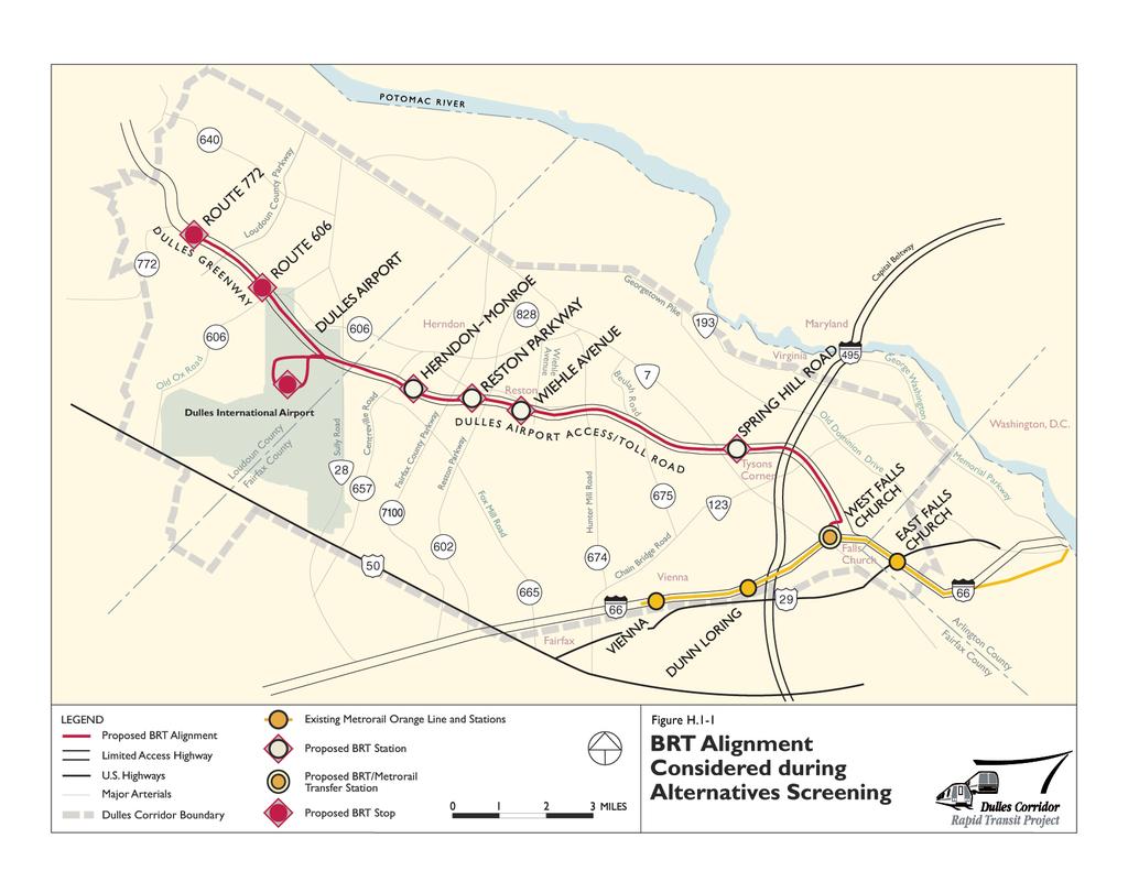
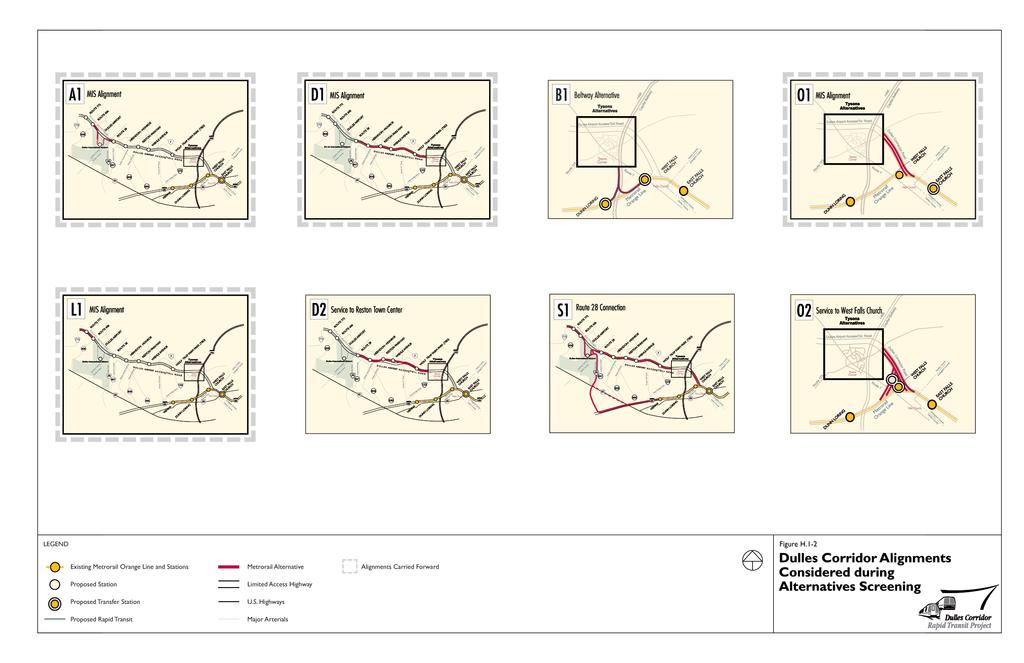
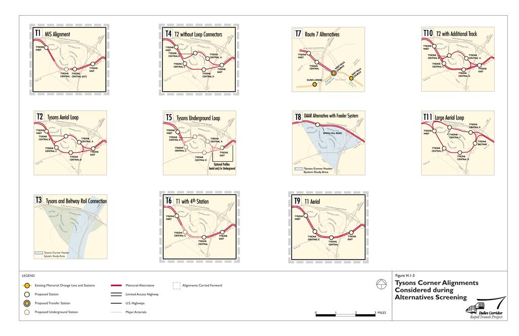
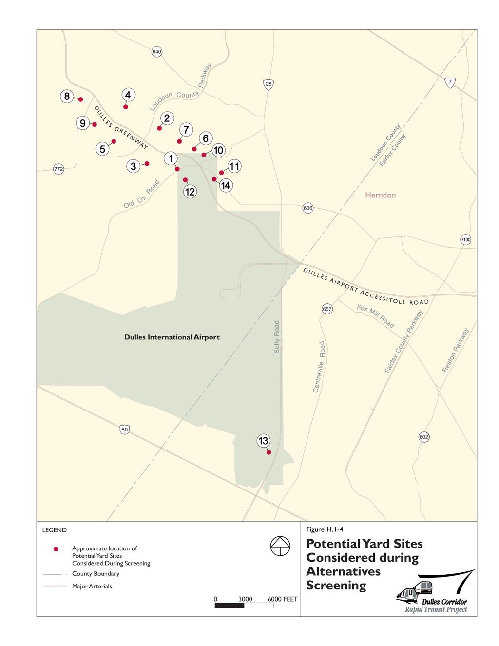
4 H.1.1 INITIAL NEPA ALTERNATIVES As shown in Table H-1.1 and in Figures H.1-1, H.1-2, H.1-3, H.1-4, the initial set of alternatives included various rapid transit modes, alignments, station locations, and ancillary facilities. These alternatives were developed based on recommendations from the MIS and MIS Supplement (see Section 2.1 of the Final EIS) and the scoping process for the Draft EIS. Table H-1.1: Initial NEPA Alternatives Modes Alignments Stations BRT Metrorail * Light rail transit (LRT) * Personal rapid transit * Monorail * Feeder system to Metrorail stations in Tysons Corner (LRT, people mover) BRT or express buses in a dedicated lane on the DIAAH BRT Alignment. Alignment recommended in MIS Supplement. Serves Tysons Corner via DIAAH with station at Spring Hill Road. Line O1. Orange Line through Tysons Corner via Dulles Connector Road. Line O2. MIS Alignment with western leg that provides service to West Falls Church Station. Line T1. Tysons Corner via Route 123 and Route 7. Line T2. Tysons Corner aerial loop via Route 123, Route 7, and Westpark Drive. Line T3. Alignment that connects the Dulles Corridor Rapid Transit Project to a possible rail line in the Capital Beltway Corridor. Line T4. Alignment T2 with pocket tracks instead of loop connectors. Line T5. Underground loop alignment. Line T6. Alignment T1 with an additional station. Line T7. Alignment from the Orange Line through Tysons Corner via Route 7. * Line T8. Station in DIAAH near Spring Hill Road that connects to a feeder system to serve Tysons Corner. Line T9. Alignment T1 with a completely aerial structure. Line T10. Alignment T2 with an additional track on the southern leg of the loop. Line T11. Large aerial loop that would include a station adjacent to the Capital Beltway. This alignment could connect to Alignment B1 as well as a possible future transit line in the Beltway Corridor. (This alignment was developed by WMATA subsequent to the scoping process.) Line B1. Orange Line connection via the Capital Beltway. Line D1. Tysons Corner to Washington Dulles International Airport via DIAAH or DIAAH median. * Line D2. Direct service to Reston Town Center via the Washington & Old Dominion Railroad Regional Park. Line A1. Dulles Airport via service roads for BRT and underground alignment for Metrorail. Line L1. Dulles Airport to Route 772 in Loudoun County via Dulles Greenway. Line S1. Combined rail alignments in Dulles, I-66, Route 50, and Route 28 corridors. Spring Hill Road (BRT) Tysons East (Metrorail) Tysons Central (Metrorail, T1) Tysons Central Alternative. Shift of Tysons Central Station for T1 to the east. (Metrorail) Tysons Central A, B, C, and D (Metrorail, T2) Tysons West (Metrorail) Tysons East and West with third tracks and second platform (comparable to configuration at National Airport). (Metrorail) BRT/Metrorail Transfer Station (location to be determined) * Wolf Trap Farm Park. Determine whether station is viable. (Metrorail) Addition of Hunter Mill Road Station (Metrorail) Wiehle Avenue (BRT to Metrorail) * Removal of Wiehle Avenue Station (BRT to Metrorail) Reston Parkway (BRT to Metrorail) Relocate Wiehle Avenue and Reston Parkway stations near or under the highway overpasses (BRT to Metrorail) Herndon-Monroe (BRT to Metrorail) Route 28 BRT Station. Addition of a BRT station in DIAAH median (BRT to Metrorail) Route 28 (Metrorail) Accommodate a future LRT station at Route 28 (Metrorail) Dulles Airport (BRT, Metrorail) Route 606 (BRT, Metrorail) Route 772 (BRT, Metrorail) Final Environmental Impact Statement H-2 Dulles Corridor Rapid Transit Project
5
6
7
8
9
10
11
12
13 Ancillary Facilities Three yard sites along Dulles Greenway north of Dulles Airport One yard site south of the airport, adjacent to Route 28 and south of the Dulles Toll Road (DTR) Additional yard sites identified during agency coordination West Falls Church Yard Complex Traction power substations Tie-breaker stations Indicates alternatives that were examined during the MIS process, but were eliminated from further evaluation. For the stations, BRT to Metrorail indicates BRT stations that would be convertible to Metrorail, and BRT, Metrorail indicates locations that would have BRT stops or Metrorail stations. During the alternatives analysis process, it was assumed that the BRT Maintenance and Storage Facility and the Metrorail S&I Yard would be collocated on a single site. Because of the large number of rail alignment alternatives, the corridor was divided into geographic sections to facilitate presentation and discussion. The labels of the alignments conform to the sections of the corridor below, and are presented in general east-to-west order: O is for the section of line connecting to the existing Metrorail Orange Line. B is for a transit line under study in the Beltway Corridor. T is for the section of line in Tysons Corner. D is for the section of line in the Dulles Airport Access Road. A is for the section of line at Dulles Airport. L is for the section of line in Loudoun County. S is for a rail line in the Sully Road (Route 28) corridor. The development of the initial National Environmental Policy Act of 1969 (NEPA) alternatives is described in more detail in the Scoping Process Report (September 2000). Some alternatives were added following publication of the Scoping Process Report, in response to either ongoing engineering studies or additional public comment. H.1.2 EVALUATION PROCESS To determine which alternatives would move forward for detailed evaluation in this Draft EIS, the initial NEPA alternatives were evaluated and screened in a two-phase process: initial screening and intermediate screening. As outlined in the Evaluation Methodology Report, the process applied increasingly detailed and comprehensive measures of effectiveness to a decreasing number of alternatives. The alternatives advanced or carried forward for further evaluation at the end of each phase were the ones that were determined to best achieve the following: Improved transportation service; Increased transit ridership; Supported future development; Supported environmental quality; Provided cost-effective, achievable transportation choices; and Served diverse populations. These project goals are based on those originally developed during the 1997 MIS. Final Environmental Impact Statement H-7 Dulles Corridor Rapid Transit Project
14 The intent of the initial and intermediate screening evaluations was to compare the relative performance of a large number of alternatives using a small number of criteria. The four basic categories of evaluation criteria identified in the Evaluation Methodology Report are social, environmental, economic, and transportation. Analysis of performance relative to these criteria enabled the project team to distinguish between those alternatives that were likely to be most effective in meeting the project s goals and those that were not. The results of the alternatives screening process are presented in Table H.1-2. Each of the alternatives eliminated from further consideration is discussed in more detail in the following sections. H.1.3 INITIAL SCREENING The initial screening criteria, as defined in the Evaluation Methodology Report, included consistency with land use plans, order of magnitude capital costs, service to activity centers within the Dulles Corridor and the region, and compatibility with existing infrastructure, among others. At this level of analysis, most measures were qualitative. Because not all of these criteria are sensitive to differences between modes, the initial screening was conducted as a two-part process. First, the modes (i.e., Metrorail, BRT, light rail, personal rapid transit, and monorail) were reviewed using appropriate measures of effectiveness. Then, the alternative alignments, stations, and ancillary facilities were evaluated. The following sections identify the alternatives that were eliminated from further study during initial screening and summarize why these alternatives were not carried forward for additional analysis. H Modes Several modes added to the list of alternatives during the scoping process were previously examined and eliminated from further study during the 1997 MIS. The project team reviewed the reasons for the decisions to eliminate these modes and reaffirmed the validity of these decisions based on current data. Light Rail Transit Light rail transit was suggested in lieu of Metrorail because it is a rail technology that can operate on alignments that are not grade-separated. Typically, light rail is a mode that consists of passenger rail cars operating in short trains. The cars are usually powered electrically by overhead catenary lines, although diesel-powered systems do exist. This mode was eliminated during the 1997 MIS. It was determined that light rail would not be as cost-effective as Metrorail because it would require a transfer at the Metrorail Orange Line, which would reduce ridership in the Dulles Corridor. Also, the capital costs for light rail would be similar to those for Metrorail because it would have to follow the same grade-separated alignment as a Metrorail alternative through Tysons Corner and at Dulles Airport, reducing any potential cost-savings benefits. For these reasons, light rail transit was eliminated from further consideration. Personal Rapid Transit Personal rapid transit is a technology typically envisioned to function like an automobile in an urban setting. The technology uses small, low-capacity vehicles (one to four persons) and, ideally, would have numerous closely spaced stations in a dense guideway network. Final Environmental Impact Statement H-8 Dulles Corridor Rapid Transit Project
15 This mode, eliminated during the 1997 MIS, was also suggested in lieu of Metrorail, but was eliminated from further consideration because it is not a technology intended to provide the long-distance, highspeed service required in the Dulles Corridor. Table H.1-2: Alternatives Considered During the Screening Process MODES ALIGNMENTS STATIONS ANCILLARY FACILITIES Alternatives Eliminated in Initial Screening Personal Rapid Transit Light Rail Transit (LRT) Monorail Feeder System to Metrorail stations in Tysons Corner BRT or Express Buses in a Dedicated Lane on the DIAAH Route 7 (T7) Tysons DIAAH Station with Feeder System (T8) Partial Double-Track Loop (T10) Large Aerial Loop (T11) Beltway Access thru Tysons (B1) Direct Service to Reston Town Center (D2) Dulles, I-66, Route 50, and Route 28 Connection (S1) Stations that were only associated with Alignments T7, T8, T11, and D2 Addition of Hunter Mill Road Station Removal of Wiehle Avenue Station Nine potential yard sites in Loudoun County Alternatives Eliminated in Intermediate Screening None Service to West Falls Church (O2) Tysons Loops (T2, T5) Interface with Beltway Rail Line (T3) (a) Platform connection to West Falls Church for O2 The MIS Tysons Central Station for T1 Wolf Trap Farm Park Station as a special use station (c) Relocation of the Wiehle Avenue and Reston Parkway stations under or near the highway overpasses Accommodation for Route 28 LRT (a) Two sites for BRT maintenance facility and rail yard near Route 606 interchange (Y6, Y10) Rail yard site at south end of Dulles Airport property (Y13) Two potential yard sites in Loudoun County and three sites on Dulles Airport as part of a supplemental study. Alternatives Evaluated in Draft EIS BRT Metrorail MIS Supplement BRT Alignment (b) MIS Rail Alignment (O1, T1, D1, A1, L1) Tysons MIS Alignment Variations (T6, T9) (d) Tysons Loop (T4) Stations and stops associated with the MIS Supplement BRT Alignment Stations associated with the MIS Metrorail Alignment and its variations (O1, T1, D1, A1, L1 and T6, T9) (d) Stations associated with the Tysons loop alignment (T4) Route 28 BRT Station Tysons Central Alternative Station Tysons East and West stations with third track One rail yard site near Route 606 interchange (Y7) (e) One BRT maintenance facility site at north end of Dulles Airport property (Y14) (e) Two additional sites south of the Dulles Greenway along Route 606 (Y15, Y20) (f) West Falls Church Yard Complex a In the future, the project team will cooperate with the groups implementing these projects and coordinate design with them to the extent feasible. b The BRT alignment was refined after Intermediate Screening. Two options were added with varying station and stop locations. c Only provisions to accommodate a future station at Wolf Trap Farm Park were evaluated in the Draft EIS. d Alignment T9 was refined after Intermediate Screening. It remained a largely aerial alignment, with a short underground section. A technical memorandum was prepared discussing the rationale for revising Alignment T9. e Site 14 was introduced after Intermediate Screening. It was carried forward in lieu of Site 7 for the BRT maintenance facility. f Sites 15 and 20 were introduced after Intermediate Screening as part of the Supplemental Rail Yard Study (described in more detail in Section 2.6.5). Site 15 would include a rail yard only. Site 20 could support both a BRT maintenance facility and a rail yard. Final Environmental Impact Statement H-9 Dulles Corridor Rapid Transit Project
16 Monorail Monorail consists of automated transit vehicles operating on or suspended from a single rail, beam, or tube. Even though it was eliminated during the 1997 MIS, monorail was considered in lieu of Metrorail in the Dulles Corridor. As was the case with light rail, monorail would not be as cost-effective as a Metrorail alternative due to comparable or higher capital costs and lower ridership resulting from the forced transfer at the Orange Line. Therefore, monorail was eliminated from further consideration. Feeder Systems Different feeder system alternatives considered for the project included light rail transit and an elevated people-mover within Tysons Corner as a feeder to Dulles Corridor stations. People-movers are typically automated rail systems that use passenger vehicles operating individually or in multi-car trains. The guideway for this mode must be grade-separated. These options for a fixed-guideway feeder system were eliminated from further consideration because they would not be cost-effective. Analysis conducted for the MIS demonstrated that a fixed-guideway feeder system would not enhance ridership on a Dulles Corridor line that followed either a Route 123- Route 7 alignment or a loop configuration in Tysons Corner. Moreover, the analysis showed that such a feeder system would substantially add to the cost of the project. Given that the feeder system would not substantially increase ridership on the Dulles Corridor line as a whole, it would be considered an unreasonable expenditure in the context of the Dulles Corridor Rapid Transit Project. BRT or Express Bus (in lieu of BRT) Operating in Dedicated Third Lane on the DIAAH These options were eliminated from further consideration because current and future traffic projections for the existing configuration of the DIAAH do not warrant construction of a dedicated lane as part of the Dulles Corridor Rapid Transit Project. Because the DIAAH only provides service to and from the airport and does not serve general traffic, it is expected that traffic flow on this road during peak periods will be, at worst, moderately congested. This flow of traffic would not interfere with the speed or reliability of bus operations in the DIAAH. When traffic flow on the DIAAH degrades, the Metropolitan Washington Airports Authority (MWAA) plans to build this additional lane for all airport traffic. Current express bus operations in the corridor and planned operational enhancements are part of the phased implementation program recommended in the MIS Supplement. These operations were analyzed as an alternative to BRT as part of the No Build Alternative. H Alignments With the exception of the BRT alignment, most of the alignment alternatives under consideration were variations of the rail alignment recommended in the MIS. Each of the alignments eliminated during initial screening and discussed below were proposed rail alignments. Route 7 Connection (T7) Alignment T7 was a connection from the Orange Line through Tysons Corner via Route 7. This alignment was eliminated from further consideration because it would not serve the eastern part of the Tysons Corner area as effectively as other proposed alternatives. Final Environmental Impact Statement H-10 Dulles Corridor Rapid Transit Project
17 DIAAH Alternative with a Feeder System (T8) Alignment T8 consisted of a rail station in the DIAAH near Spring Hill Road that connected to a feeder system to serve Tysons Corner. This alignment was examined during the MIS and was eliminated from further consideration because ridership would be lower due to the forced transfer between Metrorail and the feeder system. In addition, it was determined that this alternative might have impacts on residences and historic resources near the Spring Hill Road Station. The MIS assumptions were examined and verified during initial screening. Partial Double-Track Loop (T10) This alignment consisted of an aerial loop in Tysons Corner following Route 123, Route 7, and Westpark Drive with a double-track configuration on the southern leg of the loop. It was determined that T10 could provide operational flexibility in Tysons Corner; however, this flexibility could be provided through less costly options. The alternative was eliminated from further consideration because its additional costs and impacts would yield little or no additional benefit, particularly given that T10 was not likely to provide better service than the single-track loop configuration under consideration. Beltway Connection (B1 and T11) Alignment B1 provided an Orange Line connection via the Capital Beltway, while Alignment T11 consisted of a large aerial loop that would include a station adjacent to the Capital Beltway. Alignment T11 could connect to Alignment B1, as well as a possible future transit line in the Beltway Corridor. Alignments B1 and T11 were eliminated from further consideration because they would have higher costs but not greater benefits than other proposed alternatives. Because of the planned widening of the Beltway, I-66, Route 7, and Route 123, implementation of Alignment B1 would require significant right-ofway acquisition at substantial cost. In addition, the larger loop of Alignment T11 would provide inferior service coverage compared to other loop alternatives and would be more costly than the smaller loop. Alignment D2 Alignment D2 would provide direct service to Reston Town Center via the Washington & Old Dominion (W&OD) Railroad Regional Park, in lieu of the indirect service provided by an alignment in the DIAAH median. Alignment D2 is not consistent with existing land use, nor is it consistent with local or regional land use plans. Development of Alignment D2 would not preclude other planned improvements from occurring, but it would preclude the continued use of the W&OD Railroad Regional Park in certain areas because parkland would be converted for permanent use as a rail line. Because the DIAAH median alignment provides a prudent and feasible alternative to the use of this parkland, and would not have impacts on the park, Alignment D2 was eliminated from further consideration, consistent with Section 4(f) of the U.S. Department of Transportation Act of Alignment S1 Several alignments suggested during the scoping process involved connections to transit improvements in the corridor that are either currently under study or are identified in long-range plans. Alignment S1 combined the proposed Dulles Corridor alignment with two other rail alignments: one an Orange Line extension in the I-66 Corridor that is currently under study as a separate project, and the other a proposed rail line along the Route 28 and Route 50 corridors. This large loop alignment was eliminated from further consideration because it was inconsistent with federal guidelines for defining the scope of a project for evaluation in an EIS. The guidelines state that a proposed project should have logical endpoints and should be usable as an independent improvement, even if additional transportation Final Environmental Impact Statement H-11 Dulles Corridor Rapid Transit Project
18 improvements in the area are not made. The various segments of Alignment S1 would each have logical endpoints and would function as independent improvements if the other segments were not developed. Therefore, each should be studied as a separate project. H Stations Stations that were located only on alignments that were eliminated from further consideration were also eliminated. For example, Alignment D2 was eliminated from further consideration, precluding stations proposed along the former W&OD right-of-way at Wiehle Avenue and Reston Town Center. Summarized below is the initial screening analysis for eliminated station alternatives that were not alignment-specific. Hunter Mill Road Station The proposed Hunter Mill Road Station was eliminated from further consideration because the station is not consistent with current or planned land use in the vicinity. Low-density land uses surrounding the proposed site would not generate enough ridership to support a station at this location. In addition, the citizens in the area have expressed strong opposition to a station at Hunter Mill Road. The Dulles Corridor Land Use Task Force, appointed by the Fairfax County Board of Supervisors, stated strong opposition to a station at Hunter Mill Road in lieu of the proposed station at Wiehle Avenue. The Task Force voted at its session on February 26, 2001 to endorse the elimination of the Hunter Mill station and continued planning for the Wiehle Avenue station. The Comprehensive Plan changes adopted by the Fairfax County Board of Supervisors on May 21, 2001 support this position; no transit-oriented land use plans have been adopted or considered for a proposed station in the vicinity of Hunter Mill Road. Though it was suggested during scoping that the proposed Wiehle Avenue Station be eliminated from the project, this station was retained for further analysis based on the current and planned uses for the area surrounding the proposed station location. These uses generate demand that cannot be adequately served by the Reston Parkway Station. As described above, the Dulles Corridor Land Use Task Force endorsed the continued consideration of the Wiehle Avenue Station. H Ancillary Facilities During initial screening, 13 potential sites were examined for the BRT Maintenance and Storage Facility and the Metrorail Service and Inspection (S&I) Yard as shown in Figure H.1-4. Four sites were recommended during the MIS and additional sites were identified during agency coordination for the Draft EIS. Nine of the proposed sites were eliminated during initial screening because they were inconsistent with local land use plans and zoning designations or because they contained or were crossed by important water resources in Loudoun County. For instance, sites located in areas consisting of, or zoned for, residential development or mixed-use and office park development were eliminated because these uses were not considered consistent with a transit system maintenance and storage facility. In addition, sites that traversed or were located near Broad Run and Horsepen Run (two streams in Loudoun County) were eliminated from further consideration. Other ancillary facilities, such as traction power substations and tie-breaker stations, were not evaluated during initial screening because siting of these facilities was not complete at that time. Final Environmental Impact Statement H-12 Dulles Corridor Rapid Transit Project
19 H.1.4 INTERMEDIATE SCREENING The alternatives carried forward from initial screening were subjected to a more robust evaluation in intermediate screening. In this phase of evaluation, many of the criteria applied during initial screening were measured more quantitatively. For instance, the initial screening only considered the number of trip generators or the amount of employment within walking distance of a station to determine an alternative s ridership potential, whereas the intermediate screening used output from the travel demand model to generate preliminary ridership estimates for the remaining alternatives. Project staff also developed preliminary capital costs for the alternatives based on standard costs for various project elements. Alternatives that were eliminated during intermediate screening and the reasons they were not carried forward for full evaluation in the Draft EIS are discussed in the following sections. H Alignments Alignments eliminated during intermediate screening were proposed Metrorail alignment alternatives. Orange Line Connection (O2) Evaluation of the Orange Line Connection focused on the relative costs and benefits of a western leg that would allow trains from the Dulles Corridor to continue directly to the western end of the Orange Line. The configuration with the western leg, called Alignment O2, was a design variation of Alignment O1, the MIS configuration for connecting to the Orange Line. Alignment O1 is the basic configuration required to allow trains from the Dulles Corridor line to connect to the rest of the Metrorail system, but would require a transfer for passengers traveling west on the Orange Line. The intermediate screening evaluation showed that Alignment O2 would cost nearly twice as much as Alignment O1, but the expected increase in ridership for Alignment O2 was negligible. In addition, Alignment O2 was expected to have greater impacts on adjacent communities. Because the higher costs and impacts associated with Alignment O2 would not be warranted by the small expected increase in ridership, it was eliminated from further consideration. Should the Orange Line be extended to Centreville in the future, travelers from the western portions of the region would be able to access the Orange Line closer to their homes and avoid traffic congestion en route to Vienna. Riders from these areas may create demand for a direct connection between the Dulles Corridor and the western end of the Orange Line. Accordingly, the design of Alignment O1 does not preclude future development of a western connection to the Orange Line. Loop Alignment and Variations (T2 and T5) Three variations of the loop alignment for serving Tysons Corner were carried forward from initial screening. These alignments were evaluated relative to one another during intermediate screening, and it was determined that two of the loops would have significantly higher costs and impacts. Due to the inclusion of loop connectors, Alignment T2 would have greater potential for visual and noise impacts on adjacent residential communities than Alignment T4 (a similar alignment without the loop connectors). Alignment T2 would also have operational difficulties, and higher capital, operating, and maintenance costs than Alignment T4, but would only provide modest ridership benefits. Alignment T5 would avoid many of the impacts of Alignments T2 and T4, but would have much higher costs than these alignments, as well as additional risks associated with underground construction. While Alignment T4 Final Environmental Impact Statement H-13 Dulles Corridor Rapid Transit Project
20 would not be without impacts, it would not have the severity of impacts or the costs associated with Alignment T2, nor would it have the capital cost and level of risk associated with Alignment T5. Based on these findings, Alignments T2 and T5 were eliminated from further consideration. Connections to Future Transit Improvements (T3) During initial screening, study of Alignment T3 was suspended until additional information was available regarding possible modes and alignments for a future rail line in the Capital Beltway Corridor. The Capital Beltway Corridor Rail Feasibility Study, released in March 2001, included recommendations for three different modes, each with a different alignment and station locations. The current Beltway rail plans are not yet developed to a level that would make it appropriate or feasible to conduct detailed coordination efforts related to those improvements. Therefore, Alignment T3 was eliminated from further consideration, as they would not be developed in a time frame consistent with the schedule for the Dulles Corridor Rapid Transit Project. As work progresses on a future Capital Beltway rail line, the Dulles Corridor Rapid Transit Project team will coordinate with the groups implementing that project and coordinate with them to the extent feasible regarding a connection between the two transit systems. H Stations Tysons Central Station During initial screening, the possibility of shifting the Tysons Central Station farther to the east for Alignment T1 was carried forward for additional analysis. In intermediate screening, it was determined that the more easterly station location (Tysons Central Alternative Station) would be less costly and would likely have more benefits than the original Tysons Central Station location. Tysons Central Alternative Station would have better connections to existing employment concentrations and to proposed office developments. It also has higher potential for joint development at sites that are currently undeveloped or underdeveloped. Therefore, the original Tysons Central Station was eliminated from further consideration in favor of the alternative location. Wolf Trap Farm Park Station Based on coordination with the National Park Service (NPS) and the Wolf Trap Foundation (a non-profit organization associated with the park), it was determined that a station at Wolf Trap would not be constructed as part of the Dulles Corridor Rapid Transit Project. The project would include provisions to accommodate a future Wolf Trap station, but the station itself and its access facilities were eliminated from further consideration. Only the provisions required to accommodate the future station were fully evaluated in the Draft EIS. Should funding for a station be identified in the future, a separate environmental review process would be required to fully evaluate the proposed station. Relocation of the Wiehle Avenue and Reston Parkway Stations Under or Near the Highway Overpasses The project team proposed that the Wiehle Avenue and Reston Parkway stations be located in the median of the DIAAH west of their corresponding highway overpasses at places where the DTR has been realigned to accommodate transit stations in the DIAAH median. During the public scoping process, it was suggested that the stations be relocated under the highway overpasses to provide better access to all four quadrants of the interchanges at Wiehle Avenue and Reston Parkway. The feasibility of this Final Environmental Impact Statement H-14 Dulles Corridor Rapid Transit Project
21 relocation was examined during initial screening. It was determined that moving the stations would be costly and have substantial impacts, but additional analysis was recommended because the benefits of the relocation were not known at that time. Following the initial analysis, stakeholders suggested that the project team should examine the feasibility of moving the stations closer to the overpasses, rather than directly under them. The stakeholders also encouraged the provision of station access from all four interchange quadrants. This option and the options originally assessed during initial screening were examined during intermediate screening. In this second analysis, it was determined that moving the stations from the locations where the Toll Road was realigned would increase costs and impacts but would offer no significant benefits. For the central portion of the corridor, Fairfax County has amended their Comprehensive Plan to allow increased densities within the vicinity of transit stations. Because any proposed land use density bonuses would move with the stations (as discussed in the May 2001 recommendations of the Dulles Corridor Land Use Task Force), relocating the stations nearer to or under the overpasses and providing access to all four quadrants of the interchange would not increase ridership potential above that for the stations at the locations where the Toll Road was realigned. Placing the stations under the overpasses would also generate several safety concerns, including narrow shoulder widths and station security issues. These issues would necessitate rebuilding the DIAAH, the Toll Road, the highway overpasses, and the interchange ramps to accommodate the stations under the overpasses. The result would be substantial cost increases, a lengthier construction period, traffic delays, and extensive impacts on people living and working in the corridor, particularly in Reston. Similarly, moving the stations closer to the overpasses, as proposed by stakeholders, would necessitate rebuilding the highway overpasses because the proposed design would undermine the pier footings supporting the bridges. It is also possible that shoulder width considerations for this configuration could require rebuilding the DIAAH, the Toll Road, and the interchange ramps. Given these findings, such relocations of the Wiehle Avenue and Reston Parkway stations were eliminated from further consideration. Accommodation of Route 28 Light Rail Transit Accommodation of Route 28 light rail transit (LRT) was evaluated with currently available information about potential transit improvements in the Route 28 Corridor. Several studies have recommended future development of light rail transit in the Route 28 Corridor, including recent proposals by the area s transportation management agency (TMA) that would bring the alignment very near the proposed Route 28 Station for the Dulles Corridor Rapid Transit Project. However, a Route 28 LRT system is not currently included in the Virginia Transportation Development Plan, indicating that, while transit improvements have been identified as desirable in the Route 28 Corridor, no Route 28 transit study is currently being conducted nor is one currently planned by the Commonwealth. Because plans for a Route 28 LRT system have not been developed to a level that would make it appropriate or feasible to conduct detailed coordination efforts related to those improvements, accommodation of a Route 28 LRT system has been eliminated from further consideration. Final Environmental Impact Statement H-15 Dulles Corridor Rapid Transit Project
22 H Ancillary Facilities Four proposed sites for a BRT Maintenance and Storage Facility and a Metrorail S&I Yard were carried forward for further evaluation in intermediate screening. They include three sites near the Route 606 interchange with the Dulles Greenway (Sites 6, 7, and 10) and one site at the south end of Dulles Airport property near the National Air and Space Museum Udvar-Hazy Center (Site 13). During intermediate screening, the project team determined that each site would have the potential for the following impacts: Steep slopes, floodplains, and wetlands restrict the suitability of Site 6. Locating a maintenance and storage facility on Site 10 would require extensive property acquisition, including a historic property, from the federal government and from private properties housing existing business operations. Site 13 is inconsistent with the approved Airport Layout Plan for Dulles Airport and, like Site 6, may have environmental resources that could be affected by a S&I Yard. Furthermore, locating a S&I Yard on Site 13 would result in significantly higher capital and operating costs due to the required length of the yard lead. Although Site 7 also contains floodplains and wetlands that could be affected by a maintenance and storage facility, the relatively large size of the site allows a configuration that would minimize these impacts. In addition, Site 7 has a more optimal end-of-the-line location than Site 13 and it is closer to the mainline tracks. Based on these findings, Sites 6, 10, and 13 were eliminated from further consideration. Initially, Site 7 was carried forward as the site for both the BRT Maintenance and Storage Facility and the Metrorail S&I Yard. Following the publication of the Final Alternatives Analysis Report, MWAA made a parcel of land on the northern part of the Dulles Airport property available for use as the BRT Maintenance and Storage Facility. This new site, Site 14, was screened using the same criteria applied to potential yard sites during initial and intermediate screening. It was determined that though the site has some floodplain and wetland restrictions, it is consistent with local zoning designations and the Airport Layout Plan. Moving the BRT Maintenance and Storage Facility from Site 7 to Site 14 would also allow the S&I Yard at Site 7 to be reconfigured to further minimize environmental impacts at that site. Therefore, Site 7 was eliminated from further consideration as the site for the BRT Maintenance and Storage Facility. H.2 ALTERNATIVES CONSIDERED DURING CONTINUED DEVELOPMENT OF DRAFT EIS Following the publication of the Final Alternatives Analysis Report, the ongoing development and review of alternatives for the Draft EIS resulted in several design refinements of existing alternatives, as well as the identification of new alternatives. In order to provide an equivalent evaluation, these alternatives were assessed using the same criteria applied during initial and intermediate screening. The results of these analyses are documented in post-screening technical memoranda. Many of the refinements identified during this period were carried forward for further evaluation, some in lieu of alternatives that were previously carried forward. Those alternatives that were eliminated from further consideration, and the reasons for their elimination, are discussed below. Final Environmental Impact Statement H-16 Dulles Corridor Rapid Transit Project
23 H.2.1 ALIGNMENT T9 The T9 alignment carried forward from intermediate screening was an entirely elevated version of Alignment T1 with an optional station at the Tysons Central C location. The Tysons Central Station was configured as a side-platform station with narrow track centers, while the other three stations had center platforms with wide track centers. As part of conceptual design development in support of the Draft EIS, the design of Alignment T9 was refined. For T9 Revised, all stations had side platforms and narrow track centers and the profile of the alignment was lowered along Route 123. In addition, a short tunnel segment was added in the vicinity of the Route 123/Route 7 interchange. A screening evaluation of the revised alignment showed that, relative to the T9 alignment carried forward from the alternatives analysis phase, Alignment T9 (Revised) would likely offer cost savings, enhanced structural efficiencies, and several other benefits such as the reduction of visual impacts on surrounding communities. However, the revised alignment would also have a number of drawbacks including increased right-of-way requirements, and the increased potential for noise impacts in certain residential areas adjacent to the alignment. It was decided that Alignment T9 (Revised) should be carried forward in lieu of the original Alignment T9, because the trade-offs associated with the revised alignment could not be fully evaluated during screening due to the lack of detailed cost and environmental data. The original Alignment T9 was eliminated from further consideration so that a wider range of configurations could be examined in detail in the Draft EIS. H.2.2 STATION CONVERTIBILITY CONCEPTS The three Build Alternatives initially carried forward for evaluation in the Draft EIS were envisioned as three construction stages in a phased implementation program. The BRT Alternative would be constructed first; then Metrorail would be constructed from the Orange Line through Tysons Corner, connecting to BRT service between Tysons Corner and Loudoun County; and finally, Metrorail would be constructed between Tysons Corner and Loudoun County, replacing BRT service in the corridor. Although the three Build Alternatives were to be evaluated as stand-alone alternatives, it was initially proposed that the overall project move forward with the phased approach. As work on the Draft EIS progressed, it was decided to evaluate the phased implementation program as a fourth Build Alternative, called the Phased Implementation Alternative. A key element of this alternative was the DAAH median stations, which were to be constructed during the BRT phase for BRT use, then later converted to rail stations for Metrorail use. Seven concepts for converting the median BRT stations to Metrorail stations were explored. The range of concepts included center- and side-platform configurations and shared and exclusive guideway configurations. Several concepts involved constructing the full Metrorail platform prior to the beginning of BRT operations, with 260 feet of the platform temporarily configured as a low platform for BRT operations. These potential station configuration concepts were assessed against three main evaluation criteria: 1) Minimize downtime during conversion, that is, the time during which joint-use guideway areas and other station elements would be unavailable for BRT use during Metrorail start up and testing. Final Environmental Impact Statement H-17 Dulles Corridor Rapid Transit Project
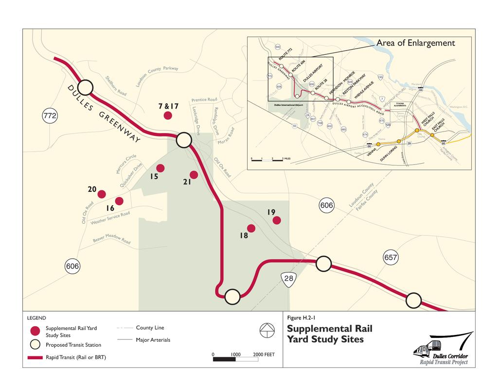
24 2) Limit BRT station width to a maximum of 80 feet so as to avoid additional widening of the DIAAH or the DTR. 3) To the extent feasible, preserve MWAA s ability to construct and operate future third lanes of the DIAAH independently of the Dulles Corridor Rapid Transit Project. In order to meet this criterion, overall station widths of 60 feet or less are necessary. Based on the evaluation, three conversion concepts were eliminated from further consideration because they violated one or both station width criteria. Two other concepts were eliminated because they would require reduced BRT running speeds, would have the potential for damage to the third rail during BRT operations, and would limit rail testing and startup to non-revenue hours. H.2.3 SUPPLEMENTAL RAIL YARD STUDY In November 2001, the Steering Committee for the Dulles Corridor Rapid Transit Project asked the DRPT and WMATA to consider alternative yard sites to Site 7. In response, the project team initiated a Supplemental Rail Yard Study to examine different end-of-line locations for a Metrorail S&I Yard. Sites were also assessed to determine the feasibility of collocating the BRT Maintenance and Storage Facility with the S&I Yard. As shown in Figure H.2-1, seven supplemental yard sites were investigated during the study, all of which were located in Loudoun County. Four of the sites were located on Dulles Airport property. All sites were evaluated using the same screening process applied to the Initial NEPA Alternatives. For initial screening, the supplemental sites were assessed at a lower level of detail against the same social, environmental, economic, and transportation criteria used during the previous alternatives analysis. Five sites were eliminated based on environmental constraints, inconsistencies with land use plans, or operational constraints. Use of two of the sites would result in impacts on the Horsepen Run wetlands system an important water resource in Loudoun County. For two other sites, the existing and planned land uses would be inconsistent with a BRT Maintenance and Storage Facility and/or an S&I Yard. A fifth site would be inconsistent with WMATA design and operational requirements. Because only two sites remained following the initial screening, consensus was reached that intermediate screening was not necessary. Both remaining sites, Site 15 and Site 20, were carried forward for detailed evaluation in the Draft EIS. H.3 ALTERNATIVES CONSIDERED IN RESPONSE TO PUBLIC COMMENTS On June 28, 2002, the Draft EIS and the General Plans for the Dulles Corridor Rapid Transit Project were made available for public review and comment. The Draft EIS was also circulated to federal, state, and local agencies to solicit comments. Public hearings on the Draft EIS and General Plans were held on July 29, 30, and 31. The Project Team accepted written comments for a period of 62 days from June 28, 2002 to August 28, Final Environmental Impact Statement H-18 Dulles Corridor Rapid Transit Project
25
26
27 During this public review and comment period, several new or modified alternatives were proposed for the project. Those alternatives that were eliminated from further consideration and the reasons they were not carried forward are discussed in the following sections. H.3.1 DULLES PLAN B Dulles Plan B was a proposal put forth by several citizens in the project area. In essence, the Dulles Plan B proposal represented a modified version of alternatives already studied in detail in the Draft EIS. The Dulles Plan B proposal contended that a combination of BRT and increased use of the high-occupancy lanes along the DTR could meet the projected demand for transit in the corridor at a much lower cost than Metrorail. The proposal also suggested the implementation of several forms of private transit, including just-in-time ridesharing (i.e., casual carpooling, slug lanes) and high-occupancy toll lanes. The Project Team reviewed the range of alternatives proposed on the Dulles Plan B website, but did not recommend the alternative for further study. Although the team s analysis confirmed that increased use of the HOV lanes could have benefits for the Dulles Corridor, such an increase would not dramatically increase the person-moving capacity of the corridor. Moreover, although the proposed combination of BRT with increased vehicle capacity and increased use of the HOV lanes would provide enough capacity to support the projected demand for Metrorail, it would only do so if all new HOV users are travelers that formerly drove alone. It is very unlikely that incentives to increase HOV use would appeal only to people who previously used the general traffic lanes. It is much more likely that some of the new HOV users would be persons that would have otherwise used the transit system, reducing rather than enhancing demand for transit in the corridor. Furthermore, capacity is not what truly limits the ability of the BRT Alternative in the Dulles Corridor to serve the same level of demand as Metrorail. BRT would not have the same drawing power as Metrorail due to a forced transfer at the Metrorail Orange Line and the lack of a direct connection to Tysons Corner. The other proposed private transit modes were determined to be either infeasible in the Dulles Corridor, or not as beneficial as suggested in Dulles Plan B. H.3.2 ALIGNMENT T12 Alignment T12 was a split-service alignment, with one branch extending along the DIAAH on the north side of Tysons Corner, and a second branch penetrating the core of Tysons Corner. The north branch of Alignment T12 (or the express leg) would be constructed first; allowing service to the remainder of the corridor to begin while construction of the south branch (or local leg) is completed. The local leg of the alignment would follow one of the four Metrorail Alignments evaluated in the Draft EIS. Alignment T12 was eliminated from further consideration because it would have greater costs and impacts than the alternatives considered in the Draft EIS, would not effectively serve corridor activity centers, and would likely result in ridership reductions. In addition, the service associated with the alignment would be difficult to integrate with operations along the rest of the Metrorail system and with the Virginia Department of Transportation (VDOT) expansion plans at the Capital Beltway/DTR/Connector Road interchange. Final Environmental Impact Statement H-20 Dulles Corridor Rapid Transit Project
Fairfax County Countywide Transit Network Study
 Fairfax County Countywide Transit Network Study Proposed High Quality Transit Network Concept Metropolitan Washington Council of Governments Travel Forecasting Subcommittee September 20, 2013 1 Presentation
DULLES CORRIDOR METRORAIL PROJECT Extension to Wiehle Avenue
 DULLES CORRIDOR METRORAIL PROJECT Extension to Wiehle Avenue Submitted to the Federal Transit Administration For Final Design Submitted by Metropolitan Washington Airports Authority In cooperation with
I-66 Corridor Improvements Outside the Capital Beltway in Northern Virginia, USA
 15th International Conference on Managed Lanes I-66 Corridor Improvements Outside the Capital Beltway in Northern Virginia, USA Case Study for Funding of Transit Service and Transportation Demand Management
ATTACHMENT A. Detailed Study Scope. I-66 (Inside) Multi-modal Study Scope
 Multi-modal Study Scope") ATTACHMENT A Detailed Study Scope I-66 (Inside) Multi-modal Study Scope EXECUTIVE SUMMARY The Virginia Department of Transportation (VDOT) seeks consultant assistance in identifying and evaluating a range
ATTACHMENT A Detailed Study Scope I-66 (Inside) Multi-modal Study Scope EXECUTIVE SUMMARY The Virginia Department of Transportation (VDOT) seeks consultant assistance in identifying and evaluating a range
Dulles Corridor Metrorail Project Phase 1 & Phase 2 Updates
 Dulles Corridor Metrorail Project Phase 1 & Phase 2 Updates June 30, 2017 Charles W. Stark Executive Project Director Phase 2 Station Tour 2 Phase 1 Phase 1 Cost Summary Quarter Expenditures (Feb, Mar,
NORTHWEST CORRIDOR PROJECT. NOISE TECHNICAL REPORT 2015 Addendum Phase IV
 Noise Technical Report 2015 Addendum NOISE TECHNICAL REPORT 2015 Addendum PREPARED FOR: Federal Highway Administration and Georgia Department of Transportation PREPARED BY: Parsons Brinckerhoff Project
METRA UP-W LINE. Locally Preferred Alternative Report
 METRA UP-W LINE Cook, Kane, and DuPage Counties Illinois Alternatives Analysis Study Document #9 Locally Preferred Alternative Report August 13, 2007 Prepared by Parsons Alternatives Analysis Documents
Regional Bus Rapid Transit
 Regional Bus Rapid Transit Efforts Board Transportation Committee October 20, 2009 There are a Variety of Regional Bus Rapid Transit Study Efforts They include: NVTA s TransAction 2030 Plan Transportation
VDOT ASSESSMENT DRAFT ENVIRONMENTAL DULLES AIR CARGO, PASSENGER METRO ACCESS HIGHWAY
 LOUDOUN COUNTY PROJECT NUMBER: R000-053-032, P101; UPC NO. 103929 FEDERAL PROJECT NUMBER: STP-5A01(454) VDOT U.S. DEPARTMENT OF TRANSPORTATION FEDERAL HIGHWAY ADMINISTRATION & VIRGINIA DEPARTMENT OF TRANSPORTATION
Dulles Corridor Metrorail Project Phase 1 & Phase 2 Updates
 Dulles Corridor Metrorail Project Phase 1 & Phase 2 Updates November 29, 2017 Charles W. Stark Executive Project Director Silver Line: Phase 2 Station Tour Phase 1 Phase 1 Cost Summary Expenditures (May
M E T R O P O L I T A N W A S H I N G T O N A I R P O R T S A U T H O R I T Y. Dulles Toll Road Highway Noise Wall Program
 Dulles Toll Road Highway Noise Wall Program 1 Purpose The purpose of the Dulles Toll Road Highway Noise Wall Program is to guide the repair or replacement of existing noise walls and assess requirements
3.0 REVIEW OF PREVIOUS STUDIES
 3.0 REVIEW OF PREVIOUS STUDIES This section of the highlights the significant features from previous plans and studies that could impact the development of the I-20 East Transit Initiative. Much of the
Long-Range Plan Task Force: Draft Analysis Results
 Long-Range Plan Task Force: Draft Analysis Results November 15, 2017 Prepared for: National Capital Region Transportation Planning Board Transportation Planning Board Item #9 Presentation Components Analysis
Sunrise Project South I-205 Corridor Improvement Project
 Sunrise Project South I-205 Corridor Improvement Project January 24, 2007 Sunrise and I-205 Project Summary Conclusions Sunrise Scoping Study Key Results South I-205 Scoping Study Key Results South I-205
Chapter 2: Alternatives
 Chapter 2: Alternatives Introduction An Environmental Impact Statement (EIS) is a procedural document. In other words, the environmental planning process follows a logical sequence of development. Subsequent
1.1 Purpose of the Project
 Chapter 1 Purpose and Need for East Link Project 1.1 Purpose of the Project The purpose of the East Link Project is to expand the Sound Transit Link light rail system from Seattle to Mercer Island, Bellevue
TransAction Plan October 2017
 Transportation Action Plan for Northern Virginia TransAction Plan October 2017 TransAction is the multimodal transportation master plan for Northern Virginia. It is a long range plan addressing regional
FAIRFAX COUNTY PARK-AND-RIDE DEMAND ESTIMATION STUDY
 FAIRFAX COUNTY PARK-AND-RIDE DEMAND ESTIMATION STUDY Michael Demmon GIS Spatial Analyst Fairfax County, DOT Fairfax, VA Scudder Wagg Planner Michael Baker Jr, Inc. Richmond, VA Additional support from:
Environmental Impact Statement (EIS)/ Section 106 Public Meeting Proposed Alternatives. December 14, 2017
/ Section 106 Public Meeting Proposed Alternatives. December 14, 2017") Environmental Impact Statement (EIS)/ Section 106 Public Meeting Proposed Alternatives December 14, 2017 Today s Agenda Project Overview Project Schedule Purpose and Need Concept Screening Process Level
Environmental Impact Statement (EIS)/ Section 106 Public Meeting Proposed Alternatives December 14, 2017 Today s Agenda Project Overview Project Schedule Purpose and Need Concept Screening Process Level
Metropolitan Washington Airports Authority. Phase 2: Extension To Dulles Airport/Route 772 STATEMENT OF WORK
 Phase 2: Extension To Dulles Airport/Route 772 STATEMENT OF WORK Design Build Package P Stormwater Management Facilities February 13, 2017 Rev. 0 Statement of Work February 13, 2017 THIS PAGE INTENTIONALLY
KNOXVILLE REGIONAL TRANSIT CORRIDOR STUDY
 KNOXVILLE REGIONAL TRANSIT CORRIDOR STUDY April 2013 Alignments Alignments Magnolia Ave Northeast corridor Knoxville Transit Center Hall of Fame Dr Magnolia Ave Prosser Rd. Corridor contains commercial,
ARLINGTON COUNTY TRANSIT DEVELOPMENT PLAN
 p EXECUTIVE SUMMARY Report Prepared by: ARLINGTON COUNTY TRANSIT DEVELOPMENT PLAN The Arlington County Transit Development Plan (TDP) is an effort to evaluate and assess the performance, connectivity,
Study of Transit Alternatives in the Dulles Airport Access Road Corridor
 TRANSPORTA TJON RESEARCH RECORD 1283 51 Study of Transit Alternatives in the Dulles Airport Access Road Corridor JEFFREY M. BRUGGEMAN The median of the Dulles Airport Access Road has long been considered
TPB Scenario Study Task Force: Proposal for Development and Analysis of Two New Scenarios
 ITEM 15 TPB Scenario Study Task Force: Proposal for Development and Analysis of Two New Scenarios February 20, 2008 Proposal for Two New Scenarios o At its January 16, 2008 meeting, the Scenario Study
Atlanta BeltLine Corridor Environmental Study. Technical Advisory Committee/Agency Coordination. Kick-Off Meeting
 Atlanta BeltLine Corridor Environmental Study Technical Advisory Committee/Agency Coordination Kick-Off Meeting July 17, 2008 Overview Project Overview Objectives Milestones Why GEPA and NEPA? Environmental
2 Purpose and Need. 2.1 Study Area. I-81 Corridor Improvement Study Tier 1 Draft Environmental Impact Statement
 2 Purpose and Need 2.1 Study Area Interstate 81 (I-81) is relied upon for local and regional travel and interstate travel in the eastern United States. It extends 855 miles from Tennessee to New York at
Identification and Evaluation of Alternatives Tier 1
 Vanasse Hangen Brustlin, Inc. DRAFT 4 Identification and Evaluation of Alternatives Tier This chapter describes the initial set of alternatives that were identified to address the Purpose and Need of the
Loudoun County Chamber of Commerce
 Loudoun County Chamber of Commerce INFRASTRUCTURE INVESTMENT The Loudoun County Chamber supports managed, thoughtful growth in the county. This includes support for well-planned commercial growth and development
ITEM 11 - Information January 21, Briefing on Project Submissions for the 2015 CLRP
 ITEM 11 - Information January 21, 2015 Briefing on Project Submissions for the 2015 CLRP Staff Recommendation: Issues: Background: Receive briefing on the major projects submitted for the 2015 CLRP by
Appendix D: Functional Classification Criteria and Characteristics, and MnDOT Access Guidance
 APPENDICES Appendix D: Functional Classification Criteria and Characteristics, and MnDOT Access Guidance D.1 Functional classification identifies the role a highway or street plays in the transportation
Executive Summary October 2017
 Executive Summary The King of Prussia Rail Draft Environmental Impact Statement/Draft Section 4(f) Evaluation (DEIS) describes and summarizes the transportation and environmental benefits and impacts of
Port Jervis Line Service Strategy Report. Appendix C: Port Jervis Line Capacity Improvements Analysis
 Port Jervis Line Service Strategy Report Appendix C: Port Jervis Line Capacity Improvements Analysis January 2018 TABLE OF CONTENTS Introduction... 1 1. Future PJL Service... 1 2. Project Alternatives...
APPENDIX A TIER 1 ANALYSIS
 SPN H.004100 FEASIBILITY STUDY APPENDIX A TIER 1 ANALYSIS 040-012-042AH Appendices Lead Sheets PROVIDENCE STATE PROJECT. H.004100 The following worksheets analyze various project alternatives at various
Alternatives Analysis Executive Summary
 Durham-Orange County Corridor APRIL 2012 Prepared for: TriangleTransit Prepared by: URS Team Executive Summary Introduction The 2035 Long Range Transportation Plan, jointly adopted by the Durham Chapel
LAFAYETTE RAILROAD RELOCATION, NORFOLK SOUTHERN CORRIDOR
 LAFAYETTE RAILROAD RELOCATION, NORFOLK SOUTHERN CORRIDOR July 12, 2002 A Paper Submitted for the AREMA Annual Conference by: Paul B. Satterly, P.E. HNTB CORPORATION 111 Monument Circle, Suite 1200 Indianapolis,
I-495 HOT LANES PROJECT VIRGINIA CONCRETE CONFERENCE CONCRETE: LEADING THE WAY. Dan Staron, P.E. HNTB Corporation MARCH 4, 2010
 VIRGINIA CONCRETE CONFERENCE CONCRETE: LEADING THE WAY Dan Staron, P.E. HNTB Corporation MARCH 4, 2010 PRESENTATION OVERVIEW Project Background/Highlights Design Challenges Technical Details Concrete Applications/Details
Executive Steering Committee Meeting #1: Minutes
 Executive Steering Committee Meeting #1: Minutes DATE/TIME: November 10, 2015 9:00-11:00 AM PLACE: VDOT Northern Virginia District Office, 4975 Alliance Drive, Fairfax, VA 22030 SUBJECT: Executive Steering
Northern Intermodal Transit Facility WHAT IS AN INTERMODAL TRANSIT FACILITY?
 WHAT IS AN INTERMODAL TRANSIT FACILITY? An intermodal transit facility gathers many modes of transportation together and is strategically located to increase destination alternatives. Intermodal facilities
Project Overview. A Collaborative Effort
 Project Overview A Collaborative Effort DRPT and FRA are working closely with CSX, which owns and operates the corridor, as well as with passenger operators Amtrak and Virginia Railway Express (VRE), the
PPTA Project Pipeline
 PPTA Project Pipeline Commonwealth of Virginia May 2012 Opening Remarks The Commonwealth of Virginia was developed in the 17 th century as a risky, but ultimately highly successful business venture between
Bonnie Doon Grade Separation
 6. 2 Bonnie Doon Grade Separation Recommendation: That the April 18, 2017, Integrated Infrastructure Services report CR_4461, be received for information. Report Summary This report provides information
Interchange Workshop Report (August 2004)
") U.S. Highway 14 Corridor Study New Ulm to North Mankato Table of Contents Section Interchange Workshop Report (August 2004) Page 1. Introduction and Next Steps 1 2. Interchange Workshop Participants &
U.S. Highway 14 Corridor Study New Ulm to North Mankato Table of Contents Section Interchange Workshop Report (August 2004) Page 1. Introduction and Next Steps 1 2. Interchange Workshop Participants &
BOARD OF SUPERVISORS BUSINESS MEETING ACTION ITEM. TRANSPORTATION AND LAND USE COMMITTEE REPORT: Silver Line Comprehensive Plan Amendment Update
 BOARD OF SUPERVISORS BUSINESS MEETING ACTION ITEM Date of Meeting: October 20, 2016 # 13c SUBJECT: ELECTION DISTRICT: TRANSPORTATION AND LAND USE COMMITTEE REPORT: Silver Line Comprehensive Plan Amendment
TransAction Plan Draft for Public Comment Spring/Summer 2017
 Transportation Action Plan for Northern Virginia TransAction Plan Draft for Public Comment Spring/Summer 2017 Comments are invited on this TransAction Plan, and associated TransAction Plan Project List.
2030 Transportation Policy Plan SUMMARY PRESENTATION. Land Use Advisory Committee November 15, 2012
 2030 Transportation Policy Plan SUMMARY PRESENTATION Land Use Advisory Committee November 15, 2012 Today s Topics Transportation Policy Plan (TPP) Requirements and Background Current TPP Policies, Issues
Douglas Woods Wind Farm
 Traffic Evaluation and Access Management Report Douglas Woods Wind Farm Douglas,Massachusets Prepared for American Pro Wind 195 Libbey Parkway - Unit Two Weymouth, MA 02189 Prepared by Transportation,
Durham-Orange Light Rail Transit Project
 Durham-Orange Light Rail Transit Project Scoping Information Booklet WHAT S INSIDE What is Scoping? p. 3 How was the LPA determined? p. 3 Project development process p. 4 Project Purpose & Need p. 5 Alternatives
PUBLIC HEARING LOOP 9
 PUBLIC HEARING LOOP 9 From Interstate (I)-35E to I-45 Dallas and Ellis Counties, Texas CSJ: Loop 2964-10-005 9: I-35E to I-45 Tuesday, June 20, 20, 2017 2017 Public Hearing Introductions ELECTED & PUBLIC
PRACTITIONER S HANDBOOK
 AASHTO PRACTITIONER S HANDBOOK 03 August 2016 MANAGING THE NEPA PROCESS FOR TOLL LANES AND TOLL ROADS This Handbook provides recommendations for conducting National Environmental Policy Act (NEPA) studies
3. STATION SPACING AND SITING GUIDELINES
 3. STATION SPACING AND SITING GUIDELINES The station spacing and siting guidelines are summarized in Table 3-1. Table 3-1 also includes benchmark information for local transit service and express bus as
KAW CONNECTS EXECUTIVE SUMMARY
 Executive Summary Page E-1 Introduction KAW CONNECTS EXECUTIVE SUMMARY The Kansas Department of Transportation (KDOT) and the Kansas Turnpike Authority (KTA) have both recognized the need to plan for the
Attachment E2 Noise Technical Memorandum SR 520
 Attachment E2 Noise Technical Memorandum SR 520 Prepared for: Prepared by: Jodi Ketelsen Michael A. Minor Date: November 4, 2012 Subject: Project: Noise Modeling Results: NE 51st Street to NE 65th Street
MIC Core Pre-Schematic Program Analysis
 MIC Core Pre-Schematic Program Analysis April 2001 MIAMI INTERMODAL CENTER (MIC) PROGRAM Work Program Item No. 6113820 State Project No. 87000-1528 Financial Management Item No. 249643 PRE-SCHEMATIC DESIGN
Capital Rail Constructors: Quarterly Update to MWAA Board of Directors
 Dulles Corridor Metrorail Project Phase 2, Package A Capital Rail Constructors: Quarterly Update to MWAA Board of Directors Keith Couch Capital Rail Constructors January 2018 Agenda 1. Safety 2. Schedule
TRANSIT ALTERNATIVES ANALYSIS OF THE ROUTE 7 CORRIDOR. Background Information Report Appendix
 TRANSIT ALTERNATIVES ANALYSIS OF THE ROUTE 7 CORRIDOR Background Information Report Appendix March 2013 Prepared for: Northern Virginia Transportation Commission Prepared by: Parsons Brinckerhoff Transit
WELCOME IL 47. Community Advisory Group Meeting #5 Waubonsee Community College Wednesday, May 31, 2017
 WELCOME IL 47 Community Advisory Group Meeting #5 Waubonsee Community College Wednesday, May 31, 2017 MEETING PURPOSE MEETING AGENDA 1. Welcome/Introduction 2. Review Previous Public Involvement 3. Process/Schedule
USING A SIMULATION ENVIRONMENT FOR DYNAMIC TOLL ANALYSIS
 USING A SIMULATION ENVIRONMENT FOR DYNAMIC TOLL ANALYSIS ABSTRACT Robert Kerns and Darryn Paterson Transurban, USA 1421 Prince Street, Suite 200 Alexandria, Virginia 22314 571-527-2050; rkerns@transurban.com;
Transit Service Guidelines
 G R E AT E R VA N CO U V E R T R A N S P O RTAT I O N A U T H O R I T Y Transit Service Guidelines PUBLIC SUMMARY REPORT JUNE 2004 Greater Vancouver Transportation Authority TRANSIT SERVICE GUIDELINES
BOSTON REGION METROPOLITAN PLANNING ORGANIZATION MEMORANDUM
 BOSTON REGION METROPOLITAN PLANNING ORGANIZATION State Transportation Building Ten Park Plaza, Suite 2150 Boston, MA 02116-3968 Tel. (617) 973-7100 Fax (617) 973-8855 TTY (617) 973-7089 www.bostonmpo.org
THE COMMONWEALTH OF MASSACHUSETTS NON-NHS BRIDGE R&R POLICY
 THE COMMONWEALTH OF MASSACHUSETTS Number: P-92-010 Date: 10-08-92 - ) HIGHWAY DEPARTMENT FROM: NON-NHS BRIDGE R&R POLICY The purpose of this Engineering Directive is to formally notify Department Personnel
Sunnyside Heights (Grandview Heights Area #2) Neighbourhood Concept Plan (NCP) - Engineering Servicing and Financial Strategies
 Neighbourhood Concept Plan (NCP) - Engineering Servicing and Financial Strategies") CORPORATE REPORT NO: R236 COUNCIL DATE: November 15, 2010 REGULAR COUNCIL TO: Mayor & Council DATE: November 10, 2010 FROM: General Manager, Engineering FILE: 6520-20 (GH#2) SUBJECT: Sunnyside Heights
CORPORATE REPORT NO: R236 COUNCIL DATE: November 15, 2010 REGULAR COUNCIL TO: Mayor & Council DATE: November 10, 2010 FROM: General Manager, Engineering FILE: 6520-20 (GH#2) SUBJECT: Sunnyside Heights
Dulles Corridor Metrorail Extension Project Tunneling Options for Tysons Corner
 Dulles Corridor Metrorail Extension Project Tunneling Options for Tysons Corner John Rudolf Bechtel Infrastructure Corporation, Vienna, Virginia Vojtech Gall Gall Zeidler Consultants, LLC, Ashburn, Virginia
November 8, RE: Harrah s Station Square Casino Transportation Analysis Detailed Traffic Impact Study Review. Dear Mr. Rowe:
 November 8, 2006 Mr. Glenn Rowe, P.E. Pennsylvania Department of Transportation Bureau of Highway Safety and Traffic Engineering Commonwealth Keystone Building 400 North Street, 6 th Floor Harrisburg,
5.3 Air Quality and Greenhouse Gas Emissions
 5. NEPA 5.3 Air Quality and Greenhouse Gas Emissions For a comprehensive discussion of the Project s affected environment and cumulative impacts as it relates to air quality and greenhouse gas (GHG) emissions,
U.S. Department of Transportation Federal Transit Administration and Metropolitan Atlanta Rapid Transit Authority
 ATLANTA BELTLINE CITY OF ATLANTA, FULTON COUNTY, GA TIER 1 DRAFT ENVIRONMENTAL IMPACT STATEMENT/ SECTION 4(F) EVALUATION U.S. Department of Transportation Federal Transit Administration and Metropolitan
The Folded Interchange: An Unconventional Design for the Reconstruction of Cloverleaf Interchanges
 The Folded Interchange: An Unconventional Design for the Reconstruction of Cloverleaf Interchanges I. ABSTRACT Keith A. Riniker, PE, PTOE This paper presents the Folded Interchange design and compares
South Boston. Transportation Plan. Transportation Planning Division. Virginia Department of Transportation
 2020 Transportation Plan Developed by the Transportation Planning Division of the Virginia Department of Transportation in cooperation with the U.S. Department of Transportation, Federal Highway Administration
Air Report. Project Information PPTA/LAP. Traffic Data I-495 NORTHERN SECTION SHOULDER USE. Project Number: , C501, P101 UPC:
 Air Report Project Information Project Name: I-495 NORTHERN SECTION SHOULDER USE Project Number: 0495-029-123, C501, P101 UPC: 105130 Route Number: 495 Project Limit - From: South of Old Dominion Drive
September Public Meetings. Developing a Blueprint for the Corridor
 September Public Meetings Developing a Blueprint for the Corridor Study Background Study initiated by the Commonwealth Transportation Board (CTB) and administered by VDOT in association with VDRPT. Addresses
FUTURE BUS RAPID TRANSIT PLANS
 ATTACHMENT 1 Preferred Configuration Saskatoon Bus Rapid Transit - Preferred Configuration FUTURE BUS RAPID TRANSIT PLANS Plan For Growth Transportation Plan BRT Plan October 2017 saskatoon.ca/engage 1
Environmental Assessment May 2007
 jurisdictional waters. It is assumed that, at a minimum, a USACE Section 404 Nationwide Permit would be necessary to construct these features. The impacts of the fill into the floodplain cannot be fully
TIER 1 DRAFT ENVIRONMENTAL IMPACT STATEMENT. 7. Affected Environment, Environmental Consequences, and Mitigation Strategies
 TIER 1 DRAFT ENVIRONMENTAL IMPACT STATEMENT 7. Affected Environment, Environmental Consequences, and Mitigation Strategies Table of Contents Chapter 7 7 Affected Environment, Environmental Consequences,
Congestion Management Process 2013 Update
 OVERVIEW OF THE DALLAS-FORT WORTH CONGESTION MANAGEMENT PROCESS Traffic Congestion In The Dallas-Fort Worth Region With the Dallas-Fort Worth (DFW) urban area as its center, the North Central Texas region
ITEM 8 Action May 17, 2017
 ITEM 8 Action May 17, 2017 Approval of Maryland Department of Transportation (MDOT) Additional Project Submission for the Out-Of-Cycle Air Quality Conformity Analysis for the Amendment to the 2016 CLRP
Memorandum. FROM: Jim Ortbal Rosalynn Hughey Barry Ng TO: HONORABLE MAYOR, CITY COUNCIL. DATE: June 16, 2017
 CITY OF SANjOSE CAPITAL OF SILICON VALLEY TO: HONORABLE MAYOR, CITY COUNCIL SUBJECT: TRANSPORTATION POLICY UPDATE REQUIRED BY STATE LAW - LOS TO VMT Memorandum FROM: Jim Ortbal Rosalynn Hughey Barry Ng
Commonwealth Transportation Board Sean T. Connaughton 1401 East Broad Street (804) Chairman Richmond, Virginia Fax: (804)
 Chairman Richmond, Virginia Fax: (804)") Commonwealth Transportation Board Sean T. Connaughton 1401 East Broad Street (804) 786-1830 Chairman Richmond, Virginia 23219 Fax: (804) 786-2940 RESOLUTION OF THE COMMONWEALTH TRANSPORTATION BOARD Made
Commonwealth Transportation Board Sean T. Connaughton 1401 East Broad Street (804) 786-1830 Chairman Richmond, Virginia 23219 Fax: (804) 786-2940 RESOLUTION OF THE COMMONWEALTH TRANSPORTATION BOARD Made
6.0 Indirect Effects and Cumulative Impacts
 6.0 Effects and Impacts 6.1 Introduction This chapter of the Draft EIS addresses potential indirect and cumulative impacts of the Bottineau Transitway project. effects are those that are caused by the
Members of the Board of Directors. Laurena Weinert, Clerk of the Board
 COMMITTEE TRANSMITTAL July, 06 To: From: Subject: Members of the Board of Directors Laurena Weinert, Clerk of the Board Update on the State Route Improvement Project Between Interstate 0 and Interstate
Notice of Preparation For Link Union Station (Link US) Project. Joint Environmental Impact Statement and Environmental Impact Report
 Project. Joint Environmental Impact Statement and Environmental Impact Report") Notice of Preparation For Link Union Station (Link US) Project Joint Environmental Impact Statement and Environmental Impact Report Date: May 27, 2016 To: Subject: Project Title: From: All Interested Agencies,
Notice of Preparation For Link Union Station (Link US) Project Joint Environmental Impact Statement and Environmental Impact Report Date: May 27, 2016 To: Subject: Project Title: From: All Interested Agencies,
PRTC Strategic Plan Recommendations
 PRTC Strategic Plan s September 2017 Strategic Plan Overview Phase I Potential Funding Alternatives Strategies for establishing alternative funding sources Draft report submitted to PRTC in November 2016
Transit Oriented Development Study
 Federal Way Link Extension Transit Oriented Development Study Table of Contents Executive Summary ES 1 Chapter 1: Introduction.. 1-1 Chapter 2: Methodology. 2-1 Chapter 3: Project Overview 3-1 Chapter
Congestion Management Process Update
 report Congestion Management Process Update prepared for Houston-Galveston Area Council prepared by Cambridge Systematics, Inc. 10415 Morado Circle, Building II, Suite 340 Austin, TX 78759 with Alliance
Dulles Toll Road Highway Traffic Noise Policy. February 2, 2011
 Dulles Toll Road Highway Traffic Noise Policy February 2, 2011 as revised February 1, 2012 Table of Contents 1. Purpose... 1 2. Definitions... 1 3. Applicability... 5 4. Sound Fundamentals... 6 5. Highway
NATIONAL CAPITAL REGION TRANSPORTATION PLANNING BOARD
 NATIONAL CAPITAL REGION TRANSPORTATION PLANNING BOARD September 18, 2013 District Department of Transportation Federal Railroad Administration AGENDA Vision History & Background Study Area Purpose & Need
McGraw Hill Yearbook of Science & Technology Traffic Operations and Structures: : Tampa's Reversible Express Lanes
 McGraw Hill Yearbook of Science & Technology 00 Traffic Operations and Structures: : Tampa's Reversible Express Lanes Journal: McGraw Hill 00 Yearbook of Science & Technology Manuscript ID: draft Manuscript
407 TRANSITWAY. Planning & Preliminary Design
 FROM EAST OF HIGHWAY 400 TO KENNEDY ROAD GWP #252-96-00 Public Information Centre #2 June 24 th and 29 th, 2010 Purpose of Public Information Centre #2 The first Public Information Centre (PIC #1) was
Skyweb Express Feasibility Study RESULTS SUMMARY
 Skyweb Express Feasibility Study RESULTS SUMMARY NTS Feasibility Report Contents EXECUTIVE SUMMARY...3 1. INTRODUCTION...7 1.1 Background...7 1.2 Objective...8 2. RIDERSHIP ANALYSIS...10 2.1 Introduction...10
Jim Alexander Director of Design and Engineering, Southwest Light Rail Transit Project
 Memorandum Date: January 15, 2014 To: CC: From: Subject: Jim Alexander Director of Design and Engineering, Southwest Light Rail Transit Project Paul Danielson, P.E. Project Manager, Southwest Light Rail
City of Brantford Chapter 3 TABLE OF CONTENTS
 Chapter 3 The Land Use & Transportation Connection TABLE OF CONTENTS 3.1 THE LAND USE & TRANSPORTATION LINK... 1 3.2 POPULATION & EMPLOYMENT GROWTH FORECASTS... 3 3.2.1 Proposed Places to Grow Plan Forecasts
INDIRECT EFFECTS AND CUMULATIVE IMPACTS TECHNICAL REPORT
 Tri-County Parkway Location Study INDIRECT EFFECTS AND CUMULATIVE IMPACTS TECHNICAL REPORT Prepared for: The Virginia Department of Transportation Prepared by: Parsons Brinckerhoff Quade and Douglas, Inc.
TRAFFIC ANALYSES TO SUPPORT NEPA STUDIES
 VIRGINIA DEPARTMENT OF TRANSPORTATION ENVIRONMENTAL DIVISION NEPA PROGRAM LOCATION STUDIES TRAFFIC ANALYSES TO SUPPORT NEPA STUDIES CONSULTANT RESOURCE GUIDANCE DOCUMENT Issued on: November 18, 2016 Last
GO RAIL NIAGARA SERVICE EXTENSION
 Business Case: Finch Avenue West Rapid Transit GO RAIL NIAGARA SERVICE EXTENSION INITIAL BUSINESS CASE Date: November, 2014 NOVEMBER 2015 Page 1 TABLE OF CONTENTS 1.0 Executive Summary...p.5 2.0 Introduction....p.6
National Capital Region Transportation Planning Board
 National Capital Region Transportation Planning Board Evaluating Alternative Scenarios for a Network of Variably Priced Highway Lanes in the Metropolitan Washington Region Final Report February, 2008 FUNDED
500 Interchange Design
 500 Interchange Design Table of Contents 501 Interchange Design... 5-1 July 2015 501.1 General... 5-1 501.2 Interchange Type... 5-1 501.2.1 General... 5-1 502 Interchange Design Considerations... 5-2 502.1
FEDERAL BOULEVARD (5 TH AVENUE TO HOWARD PLACE) PLANNING ENVIRONMENTAL LINKAGE STUDY TRAFFIC NOISE IMPACT ANALYSIS
 PLANNING ENVIRONMENTAL LINKAGE STUDY TRAFFIC NOISE IMPACT ANALYSIS") FEDERAL BOULEVARD (5 TH AVENUE TO HOWARD PLACE) PLANNING ENVIRONMENTAL LINKAGE STUDY TRAFFIC NOISE IMPACT ANALYSIS Prepared for: City and County of Denver 201 West Colfax Avenue, Department 509 Denver,
FEDERAL BOULEVARD (5 TH AVENUE TO HOWARD PLACE) PLANNING ENVIRONMENTAL LINKAGE STUDY TRAFFIC NOISE IMPACT ANALYSIS Prepared for: City and County of Denver 201 West Colfax Avenue, Department 509 Denver,
Northwest State Route 138 Corridor Improvement Project
 Northwest State Route 138 Corridor Improvement Project Los Angeles County, CA DISTRICT 7- LA- 138 (PM 0.0/36.8); DISTRICT 7- LA- 05 (PM 79.5/83.1); DISTRICT 7- LA- 14 (PM 73.4/74.4) 265100/ 0700001816
Corridors of Statewide Significance: Introduction
 Virginia s Long-Range Multimodal Transportation Plan Corridors of Statewide Significance: Introduction Prepared for: Commonwealth Transportation Board Prepared by: Office of Intermodal Planning and Investment
AGENDA COMMITTEE OF THE WHOLE COUNTY OF KANE
 AGENDA COMMITTEE OF THE WHOLE COUNTY OF KANE Tuesday, April 30, 2013 4:00 p.m. County Board Room Bldg. A A. CALL TO ORDER B. ROLL CALL C. PLEDGE OF ALLEGIANCE & PRAYER D. APPROVAL OF MINUTES: March 26,
3.2. Transportation Management Plan
 3.2 Transportation Management Plan August 2016 From: Lal, Tarsem (FHWA) [mailto:tarsem.lal@dot.gov] Sent: Tuesday, August 02, 2016 11:41 AM To: Allahdoust, Fatemeh (VDOT) Cc: Bill Lecos; Bondurant, Carol
Chapter 4: Transportation and Land Use
 Chapter 4: Transportation and Land Use Transportation and land use together make possible the wide range of destination opportunities in the region. Transportation provides the connections, and, in turn,