1.0 INTRODUCTION Study Context Study Approach LITERATURE REVIEW... 3
|
|
|
- Allyson Tyler
- 5 years ago
- Views:
Transcription

1
2 Table of Contents EXECUTIVE SUMMARY 1.0 INTRODUCTION Study Context Study Approach LITERATURE REVIEW Review of Literature and Guidelines Exposure Indices CRITERIA APPLIED IN PEEL ANALYSIS... ERROR! BOOKMARK NOT DEFINED. 4.1 Crossing Profiles Recommendations NEXT STEPS APPENDIX A APPENDIX B... ERROR! BOOKMARK NOT DEFINED. APPENDIX C... ERROR! BOOKMARK NOT DEFINED. APPENDIX D... ERROR! BOOKMARK NOT DEFINED.2 APPENDIX E... ERROR! BOOKMARK NOT DEFINED.6
3 List of Tables Table 1: Criteria for Separation... 3 Table 2: Criteria Applied for Prioritizing Locations for Grade Separation.6 Table 3: Criteria not Applied... 9 Table 4: Detailed Results of At-Grade Crossings Analysis Table 5: 2031 Forecasted Truck, Vehicle and Train Volumes and Resulting 2031 Exposure Index for Four Identified At-Grade Crossings. 15 Table B-1: Annual Growth Rate Calculated for the Bolton Area Table B-2: Summary of Current and Projected Average Annual Daily Traffic (AADT) Volumes for the King Street At-Grade Crossing Table B-3: Summary of Current and Projected Average Annual Daily Traffic (AADT) Volumes for the Coleraine Drive At-Grade Crossing Table B-4: Annual Growth Rate Calculated for the Winston Churchill Blvd. At-Grade Crossing Area 27 Table B-5: Summary of Current and Projected Average Annual Daily Traffic (AADT) Volumes for the Winston Churchill Blvd. At-Grade Crossing Table B-6: Annual Growth Rate Calculated for the Bovaird Drive At- Grade Crossing Area 30 Table B-7: Summary of Current and Projected Average Annual Daily Traffic (AADT) Volumes for the Bovaird Drive At- Grade Crossing Area Table C-1: Labels of Traffic Super Zone 35 List of Figures Figure B-1: King Street between Humber Station Road and Harvest Moon Drive, Caledon. 21 Figure B-2: Bolton Residential Expansion Area Figure B-3: Winston Churchill Blvd. between Wanless Drive and Adamson Street North, Brampton. 26 Figure B-4: Bovaird Drive between Van Kirk Drive and Gillingham Drive, Brampton... 29
4 EXECUTIVE SUMMARY Purpose Improving the efficiency of goods movement in and through the Regional Municipality of Peel (Peel or Region) is Peel Term of Council Priority 15. The Peel Goods Movement Task Force (PGMTF) was established in 2009 to realize this goal by advocating for transportation policy and infrastructure that: Supports the movement of goods by delivering services quickly and efficiently, Maximizes economic opportunities, and Reduces associated environmental and community impacts. The PGMTF s Technical Working Group identified 23 action items to be addressed over five years ( ) in response. Action item 4 called for prioritizing at-grade rail crossings on Regional roads for separation. The purpose of this study is to identify all at-grade rail crossings that occur on Regional roads in Peel and determine which crossings should be prioritized for separation. This would not only satisfy action item 4, but also compliments the Regional Official Plan and Long Range Transportation Plan. Background Goods movement makes up a large part of Peel s economy. There are over 2000 trucking companies in the Region and truck activity in Peel represents 25% of all truck activity in Ontario. When combined with manufacturing, goods movement accounts for 27% of the Region s employment. Peel s roads are congested which affects the reliability and predictability of the movement of goods and people, in turn threatening the Region s economic competitiveness. As such, infrastructure investments that reduce congestion, such as grade-separation of rail and road intersections, are a priority for the Region. Findings After reviewing various grade separation criteria used across North America and beyond and applying them in Peel, two at-grade crossings have been recommended for separation, pending further study, through a feasibility assessment. Recommendations As a result of applying a basic exposure index and criteria identified as appropriate for Peel s context, the following is being recommended:
5 1. The two at-grade rail crossings located in Bolton, on Coleraine Drive and King Street, should be further studied through a feasibility assessment to evaluate the impact of separation. It is important to note that it is not necessary to grade separate these crossings immediately as their exposure indices are currently below Transport Canada s threshold, but barring any significant unexpected issues grade separation should be considered within the next 10 years. 2. The other 10 crossings that were not identified for further grade separation assessment at this time should continue to be regularly maintained by the Region in accordance with the most current version of Transport Canada s Road/Railway Grade Crossings Technical Standards and Inspection, Testing and Maintenance Requirements until conditions warrant a reexamination of grade separation needs.
6 1.0 INTRODUCTION Improving the efficiency of goods movement within and through the Regional Municipality of Peel (Peel or Region) is Peel Term of Council Priority 15. To meet this priority Peel Regional Council directed staff to facilitate the formation of the Peel Goods Movement Task Force. The mission of the Task Force is to support businesses by advocating for transportation policy and infrastructure that: Moves goods and delivers services quickly and efficiently, Maximizes economic opportunities, and Reduces associated environmental and community impacts. The Task Force, through its Technical Working Group, identified 23 action items to be addressed over five years ( ). Action item 4 is to prioritize at-grade rail crossings for separation in partnership with Transport Canada, the Canadian National Railway, the Canadian Pacific Railway, the Orangeville-Brampton Railway (OBRY), and Peel s area municipalities. In addition to being a Term of Council Priority, both the Regional Official Plan (ROP) and Peel s Long Range Transportation Plan (LRTP) acknowledge the importance of goods movement. They both seek to efficiently use existing and new Regional transportation infrastructure to enhance economic vitality, sustain long-term growth and minimize adverse environmental and human health impacts caused by transportation. The purpose of this study is to identify all at-grade rail crossings that occur on Regional roads in Peel and determine which crossings should be prioritized for separation. This would not only satisfy action item 4, but also compliments the Regional Official Plan and Long Range Transportation Plan. 1.1 STUDY CONTEXT Peel Region is strategically located in the west-central portion of the Greater Toronto and Hamilton Area (GTHA). It is composed of the Cities of Brampton and Mississauga and the Town of Caledon which are referred to as the area municipalities. The Region covers approximately 1,254 square kilometers and consists of a diverse range of urban, suburban, rural, agricultural, industrial, commercial and undeveloped land. Peel is one of Ontario s fastest growing regions. By 2031, the population is expected to expand by 42%, reaching 1.64 million residents. Employment growth is expected to expand by 64%, from 530,000 to 870,000 workers by Rapid population and employment growth has, and will continue to, put pressure on Regional roads and infrastructure (1). Goods Movement Peel is one of Canada s most important goods movement hubs. Within the Region there are major arterials and highways that connect the Region to Canadian and US markets, the Toronto Pearson International Airport and both the Canadian National (CN) and the Canadian Pacific (CP) Railway 1
7 lines. There is also a major intermodal hub in Mississauga (CN) and two other intermodal hubs located just outside of the Region s borders, to the east and west. There are over 2000 trucking companies in Peel, and truck activity in Peel represents 25% of all truck activity in Ontario. Goods movement, when combined with manufacturing, accounts for 27% of Peel s employment (2). Peel s roads are congested which impacts the goods movement industry. Congestion affects the reliability and predictability of the movement of goods and people, thereby threatening the Region s economic competitiveness. Road and Rail Crossings Within Peel there are 35 intersections of railway lines (moving people or goods) and Regional Roads. Twenty-three of these intersections are grade separated (above or below ground) and 12 crossings occur at-grade (in the same location and elevation). At-grade rail crossings create conflicts between the movement of goods and people and have an impact on the quality of life in the surrounding communities. At these crossings, two distinct transportation modes meet differing in physical characteristics, speed and purpose. As a result, traffic flows are affected for one or the other transportation mode. Key Stakeholders Many stakeholders are impacted by this study and its outcomes. They either play a regulatory role or operate or maintain infrastructure in Peel. The stakeholders that were consulted by Peel staff in preparation of the study include: Transport Canada The Ministry of Transportation Metrolinx The City of Brampton The City of Mississauga The Town of Caledon Canadian National Railway Canadian Pacific Railway Orangeville Brampton Railway 1.2 STUDY APPROACH The study began with consultation with CN, CP and OBRY, to identify all at-grade rail crossings on the Region s roads (map in Appendix A). Next, a literature review was conducted to learn about criteria commonly used to determine whether crossings are candidates for separation. The process then considered the Regional context, the purpose of this study, and various data constraints to determine which criteria are appropriate for local use. Finally, four at-grade crossings in Peel that are candidates for further assessment were identified and two have been recommended for further study to understand the costs and benefits associated with their separation. 2
8 2.0 LITERATURE REVIEW Literature from North America and Australia was reviewed to understand how different criteria have been applied to at-grade rail crossings for determining if they are candidates for grade-separation. The review guided the development of screening criteria for the 12 at grade-rail crossings in Peel to determine which ones should be further assessed and prioritized for separation. 2.1 REVIEW OF LITERATURE AND GUIDELINES Reports and studies from cities, regions or states that have explicit methods for prioritizing crossings for separation and are applicable to Peel were examined. The reports came from: Melbourne, Australia Claremore, Oklahoma Riverside County, California Kern County, California Livingston, Montana Burlington, Ontario The following documents and guidelines were also reviewed: Pedestrian Safety at Grade Crossing Guide, Transport Canada Railroad-Highway Grade Crossing Handbook, US Department of Transportation Based on the literature review, criteria for prioritizing at-grade rail crossings for separation are shown in Table 1. Table 1: Criteria for Separation Criteria Reference Projected vehicular, truck and train volume growth Congestion relief/ travel time savings Melbourne, Australia Burlington, Ontario Riverside County, California Melbourne, Australia Livingston, Montana Riverside County, California Kern County, California Accident reduction Melbourne, Australia Claremore, Oklahoma Riverside County, California Kern County, California Kern County, California Livingston, Montana Claremore, Oklahoma Grade Crossing Handbook Transport Canada s Pedestrian Safety at Grade Crossing Guide Development impacts/future planning projects Melbourne, Australia Riverside County, California Burlington, Ontario Claremore, Oklahoma Emissions reduction Melbourne, Australia Riverside County, California Claremore, Oklahoma Burlington, Ontario Grade Crossing Handbook 3
9 Constructability/cost of treatment at that site Grade Crossing Handbook Emergency vehicle access Burlington, Ontario Claremore, Oklahoma Proximity of nearby crossings Melbourne, Australia Riverside County, California Current and anticipated transit Melbourne, Australia coverage Livingston, Montana Claremore, Oklahoma 2.2 EXPOSURE INDICES Many of the jurisdictions reviewed employ an exposure index as a primary screening tool. An exposure index looks at the average number of trains that cross a specific location along a road each day multiplied by the average daily traffic that cross the road at the same location. The resulting rate is objective and allows for crossings to be screened based on volumes of both trains and road vehicles. This approach quickly identifies whether a crossing would benefit from grade separation, based on minimizing traffic related delays and associated economic losses (4) (5) that result from delay. While the primary inputs of the exposure index are train and vehicular volumes, other measures can also be added depending on the objectives of the study such as train speed, vehicle speed, sight distance, protection factors (gates, lights, signs) and crossing width. Qualitative factors can also be used as input such as the types of vehicles using the crossing (passenger trains, those carrying hazardous goods, etc.) or requests from the public (4). The exposure index can be misleading as the length of the train and the time of day are not considered. Both of these factors can have a significant impact on the overall exposure of the at-grade crossing. For the purpose of this study, a basic exposure index was used, multiplying the number of vehicles using a crossing by the volume of trains at each crossing. This method has been used by the Town of Milton and York Region (which has 42 at-grade railway crossings on Regional roads) when assessing their at-grade crossings for separation. Transport Canada encourages the use of an exposure index threshold of 200,000 (includes all vehicles not just goods movement vehicles) as one of the factors in determining if a crossing should be funded for separation. None of the 12 crossings considered in this report currently meet this Transport Canada threshold, but some will exceed it in the next ten years. In its basic form the exposure index is only one level of evaluation. It should be considered with other criteria described previously to determine whether or not to grade separate a crossing. 4
10 3.0 CRITERIA APPLIED IN PEEL Although nine criteria emerged from the literature review, some criteria had more applicability to Peel than others. Table 2 describes the criteria derived from the literature review that were applied to all 12 at-grade crossings and used to determine which crossings required further analysis. Table 3 shows the reasons why other criteria were not considered. 5
11 Table 2: Criteria Applied for Prioritizing Locations for Grade Separation Criteria Applied Applicability to Peel Calculation Existing and projected vehicular, truck and train volume (2031) Development Impacts & future planning projects When considering train volumes at each of the 12 intersections the Region looked at both freight and passenger trains. It is important to note that the CP line in Caledon does not currently handle passenger movements and the OBRY line has a very limited number of passenger/excursion movements. The CN line does handle a large quantity of passenger movements for VIA Rail and GO Transit (for the Kitchener line- formerly the Georgetown line). The scope of this project is inherently focused on goods movement. As such, understanding current vehicular and truck volumes at an at-grade crossing is important to understanding how goods flow through the Region. Projecting those volumes into the future will also be important, as truck and vehicular volumes are expected to grow with new development and demographic changes. Understanding projected growth would allow the Region to predict which at-grade crossings will continue to impact goods movement flows. All railway organizations have indicated to Peel staff that their train volumes will increase in the future. However, no numbers were given at the time this study was complete. When those numbers become available Regional staff will take that into consideration. There are several important land use planning projects to consider in Peel. The Bolton Arterial Route (BAR) (Caledon): The BAR will bypass Bolton and connect King and Queen Streets, carrying vehicles north/south. Due to the industrial presence in the area, goods movement volumes are expected to increase, impacting vehicular movement around the at-grade crossings located in close proximity to the BAR. Bolton Master Plan (Caledon): Based on the Caledon Transportation Needs Study from the Bolton Master Plan will be designed to look specifically at the area of Bolton. Specifically it will take a closer look at the multi-modal transportation systems and needs in the area. Bolton Commuter Rail Service (Caledon): As part of Metrolinx s Big Move, GO commuter rail service is planned to be established in the Bolton area, although not for at least years due to Existing and projected train volumes used as input were provided by the respective railway owners. The existing truck and vehicular volumes were based on Average Annual Daily Traffic (AADT) numbers, as well as Automatic Traffic Recorder (ATR) data. Projected volumes were calculated using population and employment forecasts and applied to the traffic volumes in order to project to Calculations and a description of the process can be found in Appendix B. Information pertaining development impacts and future planning projects was gathered by Regional staff. Some of the listed projects will be expanded upon later in this report when profiling the crossings selected for 6
12 Criteria Applied Applicability to Peel Calculation funding and time constraints and low expected ridership. The preferred location for the station is at the intersection of Humber Station Road and King Street. This will lead to increased traffic flow in that area in the future. Pits and Quarries (Caledon): It is estimated that Caledon has a 100 year supply of aggregates (bedrock, sand, gravel), indicating that trucks will continue to be needed for extraction and transportation. At-grade rail crossings could interfere with the predictable and efficient flow of goods into and out of the area. Kitchener GO Transit Line (Brampton): Formerly the Georgetown Line, the Kitchener line extends from Union Station in Toronto to Kitchener and runs through Brampton at peak hours. While most of the crossings on Regional roads are separated on this line, the crossings at Mississauga Rd. and Winston Churchill Blvd. are not. Further, based on Schedule G of the Region s LRTP, this line will become a full-day service line by 2031 and because of demand, Metrolinx plans to expand the Kitchener Line to an all-day, two-way service in the future. Heritage Heights Planning Area (Brampton): Made up of Secondary Plan area 52 and 53, Heritage Heights is being planned to accommodate compact urban residential and commercial uses. This is in direct conflict with the presence of at-grade rail crossings. BramWest Parkway (Brampton): An Environmental Assessment is currently being done for the north-south arterial road that will be an extension of Financial Drive from Heritage Road to Winston Churchill Boulevard. The BramWest Parkway is intended to address capacity issues in the northwestern portion of Brampton and potentially around the nearby crossings. The Strategic Goods Movement Network (Peel Region): The systematic, hierarchical truck routes identified within the network will be protected, maintained and designed to accommodate heavy truck flows through the Region. Where a truck route intersects with an at-grade rail crossing, the flow of goods could be impacted. Meadowvale Conservation Area (Mississauga): Located south of Highway 407 and north of Old Derry Road, this area contains several natural, cultural and recreational resources that may be in conflict with at-grade rail crossings. Road Improvements (Peel Region): To cope with expected congestion and future travel demands Peel has initiated a Roads Improvement Program (RIP) to construct and maintain roads and structures. To ensure financial efficiencies, it will be important to ensure that any gradeseparations do not conflict with the improvement programs. For more detail, refer to Section 3 in Peel s Long Range Transportation Plan. further review. 7
13 Criteria Applied Applicability to Peel Calculation Other considerations In addition to the above listed criteria, there are other factors that played a role in prioritizing at-grade crossings for separation in Peel: The Orangeville Brampton Railway (OBRY): Running north-south through the western portion of Peel, the OBRY was formally owned by CP but was closed because there was not enough industry around the line for cost efficiency. Orangeville bought it for their local industry. Currently the line sees an average of 1 train per day and is primarily used for hauling of freight and tourism. Uploading of Roads: The Region, through the Arterial Road Rationalization Review, is working to upload the ownership of certain roads from the area municipalities. Currently, Coleraine Drive is being reviewed and is expected to be uploaded from Caledon in With the uploading of roads, the Region will take responsibility of all the municipal infrastructures in the right-of-way, including maintenance of rail crossings. 8
14 Table 3: Criteria Not Applied Criteria not Applied Congestion relief/ travel time savings Accident reduction Emissions reduction Constructability and the cost of treatment Explanation In order to estimate congestion relief, the length and speeds of the trains are required, along with time of day information. Train length and speed, along with projected train traffic, was requested from the railway corporations. Average speeds and number of cars were provided. While all the railway corporations said that volumes were to increase in the future, only OBRY provided this data. As such, Regional staff could not calculate the impacts based on this information. Rather than looking at congestion relief, vehicular, truck and train volumes were used instead. Maximum delay was estimated using the maximum lengths and number of cars, in order to provide information regarding the worst case delay possible. Accident data shows that there have been very few collisions at crossing locations over the last 5 years, with only one (non-fatal) collision occurring. This indicates that there is no collision trend. Modelled data may be necessary for areas that are identified for development, or if accident rates are otherwise anticipated to increase in the future. In order to measure emission reductions associated with a grade-separation, the Region would need to understand idling times. Idling times require both train length and speed as critical inputs. In addition, the emissions standards are always changing. Given the assumptions and needed data, this calculation will not yield dependable results for the Region. The need for this calculation can be re-evaluated at a later time, especially since it is a Term of Council Priority to lower greenhouse gas emissions. Depending on the number of crossings shortlisted, the constructability and cost of treatment will be valuable for the Region to understand. This factor should be explored in more detail through a feasibility analysis once the crossings prioritized for separation have been identified. This will allow for the calculation of net present values and benefit-cost ratios, which will help strengthen the go or no go decision on grade separation. 9
15 Criteria not Applied Crossing Condition Emergency vehicle access Proximity of nearby crossings Current and anticipated transit coverage Explanation Maintenance of at-grade crossings may be important to consider for those crossings not being separated. Bumps and irregular surfaces can lead to vehicles slowing down and collisions, especially during inclement weather. This factor will be important once the crossings prioritized for separation have been identified. Working with railways and the area municipalities to improve the crossings through design standards will be a cost effective way to allow for improved goods movement flow. The extent to which an at-grade crossing impacts the ability for emergency vehicles to travel to locations of emergencies in a timely manner can be considered. This is a relevant criterion in the event that an emergency occurs on the opposite side of the crossing that a hospital, fire station, etc. is located. This is particularly relevant in future build out areas in and around Bolton. Until those plans are finalized, the Region cannot use this criterion. The extent to which nearby at-grade crossings influence traffic operations can be considered. In particular, the grade separation of one crossing could lead to the ability to close a nearby at-grade crossing, thereby eliminating the corresponding maintenance and operations costs. Because of the geographic distribution of Regional Roads, this criterion may not be relevant at this time. The extent to which an at-grade crossing affects transit routes and rail and/or bus schedules can be considered since grade separation may facilitate the ability to improve transit operations and schedules. For example, with two-way-all-day service set to start on the line to Kitchener-Waterloo, the frequency of trains passing through the Winston Churchill crossing (highlighted in Section 4.1) will greatly increase. Given the evolving role of transit investments, this criterion may be better suited for a transit focused discussion rather than a goods movement conversation. 10
16 4.0 ANALYSIS All 12 at-grade crossings in Peel were considered for preliminary screening. A list of those crossings along with their estimated vehicular and truck volumes and train volumes are shown in Table 4. The exposure index based on truck and vehicular volumes are also provided. As a result of the preliminary screening four crossings were identified for grade separation consideration and described in section 4.1 (detailed profiles can be found in Appendix B) using the criteria established from the literature review. 1. King Street between Humber Station Road and Harvest Moon Drive in Caledon 2. Coleraine Drive between Ellwood Drive West and Manchester Court in Caledon 3. Winston Churchill Boulevard between Wanless Drive and Adamson Street North in Brampton 4. Bovaird Drive between Van Kirk Drive and Gillingham Drive in Brampton Note that in Table 4 the exposure index for the crossing on Mississauga Road between Bovaird Drive and Wanless Drive is 226,300, which exceeds the Transport Canada threshold. However, this crossing is already slated for grade separation in Therefore it was not considered as part of this study. Also note that crossings on the OBRY line were only considered if significant truck traffic volumes were present, as was the case for the crossing at Bovaird Drive (between Van Kirk Drive and Gillingham Drive), which sees the highest truck volumes of the 12 crossings studied. The OBRY line has extremely low train volumes at at-grade crossings so grade-separation is generally not warranted. Results After the preliminary screening, crossing profiles shown in section 4.1 were developed for the four crossings identified for further study (more detailed profiles for the locations can be found in Appendix B). While none of these crossings currently exceed the Transport Canada exposure index threshold of 200,000 they were selected for further study due to: Planned development growth in close proximity to the crossings in Caledon A combination of high volumes of either truck or train traffic combined with automobile traffic in Brampton The 2031 forecasted truck and total vehicle volumes are summarized in Table 5 and the exposure index was applied to the forecasted volumes. It is important to note that because the Region was unable to obtain data on forecasted train volumes to 2031, the EI estimate is on the conservative side, assuming no train volume increase from now until This process identified the two crossings recommended for further study: 1. King Street between Humber Station Road and Harvest Moon Drive in Caledon 2. Coleraine Drive between Ellwood Drive West and Manchester Court in Caledon 11
17 Table 4: Detailed Results of At- Grade Crossings Analysis Note: ORBY= Orangeville- Brampton Railway; CP= Canadian Pacific Railway; CN= Canadian National Railway Owner Town/City Regional Road at Railway Line Limits Truck Traffic Volumes (Daily, both directions) Truck Volume (%) Total Traffic Volumes (Total daily) Train Volumes (Both directions, total daily, approx.) Exposure Index (Trucks) Exposure Index (Total) OBRY Caledon Porterfield Rd Queen Street and Highpoint Side Road % 2, ,600 OBRY Caledon Queen St. E Main Street and Catherine Street % 2, ,600 OBRY Caledon Olde Baseline Rd McLaughlin Rd and Chinguacousy Road % 1, ,600 CP Caledon King St Humber Station Road and Harvest Moon Drive % 8, , ,800* CP Caledon Coleraine Dr Ellwood Dr W and Manchester Court % 11, , ,600* OBRY Caledon King St McLaughlin Rd and Chinguacousy Road % 6, ,500 OBRY Caledon/ Brampton Mayfield Rd McLaughlin Rd and Robertson Davies Drive/Cresthaven Road 1, % 14, ,020 14,800 OBRY Brampton Bovaird Dr W Van Kirk Drive and Gillingham Drive 4, % 46, ,800 46,700* OBRY Brampton Steeles Ave W Churchville Road and Polonia Avenue 3, % 22, ,610 22,300 CN Brampton Winston Churchill Blvd Wanless Drive and Adamson Street North % 2, ,410 74,400* CN Brampton Mississauga Rd Bovaird Dr W and Wanless Drive % 7, , ,300 OBRY Miss. Derry Rd Envoy Drive and Godwick Drive 2, % 30, ,680 30,600 *Crossings chosen for further analysis, Note: for more details on the calculation, see Appendix B 12
18 4.1 Crossing Profiles The following Crossing Profiles provide details about the four crossings identified in the preliminary screening. Additional information s can be found in Appendix B. Location & Map Crossing Characteristics Land Use Goods Movement Other Growth Forecast King Street between Humber Station Road & Harvest Moon Drive, Caledon - CP Railway line - Avg. of 16 freight trains daily - Avg. speed of 40 km/hr - Maximum train length of about 3,700m translates into a maximum delay of up to 100 minutes per day - Highest collision rate, with 7 collisions occurring between 2007 and All collisions in daylight hours and none with a train; 6 out of 7 were rear-end collisions - Automatic gates and flashing lights are sufficient in protecting pedestrian safety - Industrial/commercial land use at present and into the future - Nearby land proposed for the Bolton Employment Expansion Area, which could impact vehicular traffic - Close proximity to the Bolton Residential Expansion Study Area - Canadian Tire warehouse and distribution centre proposed for just south of the crossing, which could increase truck volumes - Limited vehicular impact expected - Concerns about the movement of paramedic vehicles from the paramedic station east of the track to residential areas west of the track - King St. intended to be a primary truck route under the Strategic Goods Movement Network (SGMN) - The Bolton Arterial Road (BAR) is planned to be complete in 2015 and will act as a goods movement route; it will be located just east of the crossing - Significant truck flow expected - Rail service between Bolton and Union Station is feasible based on estimated population and employment growth, with ridership projected to reach 4,400 daily by Preferred station location close in proximity to the crossing - While no work is expected to occur prior to 2031 on the Bolton commuter line, it is important to consider the increased vehicular traffic as well as train volumes that would be associated with it - Annual population / employment growth rates for the area: 2011 to 2021: 4.5% 2021 to 2031: 3% - Average Annual Daily Traffic (AADT) volumes, all vehicles: 2013: 8, : 13, : 17,000 - Average Annual Daily Traffic (AADT) volumes, trucks only: 2013: : 1, : 1,600 - Exposure index threshold of 200,000 will be reached in less than 10 years assuming the train frequency remains at 16 per day - Canadian Pacific Railway line is expected to grow Coleraine Drive between Ellwood Drive W & Manchester Court, Caledon - CP Railway line - Currently not on a Regional road but the Region will assume responsibility for Coleraine Dr. in Avg. of 16 freight trains daily - Avg. speed of 40 km/hr - Maximum train length of about 3,700m translates into a maximum delay of up to 100 minutes per day - 2 collisions occurred between 2007 and 2011, none involving a passing train - There was a collision with a train in 2012 as a result of the driver driving around the protective gates when they were down in an attempt to pass the train - Between residential and employment lands - Nearby land proposed for the Bolton Employment Expansion Area, which could impact vehicular traffic Close proximity to the Bolton Residential Expansion Study Area - Canadian Tire warehouse and distribution centre proposed for just south of the crossing, which could increase truck volumes - Expected further commercial and industrial development - This portion of Coleraine Dr. is classified as a primary truck route under the Strategic Goods Movement Network (SGMN) - Connections to Highway 50, the Bolton Arterial Road (BAR), and the planned GTA West corridor - Significant truck flow expected - Preferred station location close in proximity to the crossing - While no work is expected to occur prior to 2031 on the Bolton commuter line, it is important to consider the increased vehicular traffic as well as train volumes that would be associated with it - Annual population / employment growth rates for the area: 2011 to 2021: 4.5% 2021 to 2031: 3% - Average Annual Daily Traffic (AADT) volumes, all vehicles: 2013: 11, : 17, : 22,000 - Average Annual Daily Traffic (AADT) volumes, trucks only: 2013: : 1, : 1,600 - Exposure index threshold of 200,000 will be reached in less than 10 years assuming the train frequency remains at 16 per day 13
 - 14 passenger trains, 17 freight trains - Approx.")

19 Location & Map Crossing Characteristics Land Use Goods Movement Other Growth Forecast Winston Churchill Boulevard between Wanless Drive & Adamson Street N, Brampton - CN Railway line - Used for both freight and passenger trains (VIA Rail and GO Transit) - 14 passenger trains, 17 freight trains - Approx. 31 daily trains - VIA Rail: 113 km/hr - GO Transit: 93 km/hr - Freight Trains: 88 km/hr - Passenger trains take barely a minute to cross if travelling at maximum speed - Freight trains do not cause significant delays either - Maximum delay is approx. 65 minutes per day - No collisions associated with this crossing - Residential neighbourhood with greenbelt lands to the west - On border of Heritage Heights planning area - Winston Churchill Blvd. is slated to be a character road - Intention to include cycling paths, walking trails, trees, and bushes on either side of Winston Churchill Blvd. - More pedestrian oriented than goods movement oriented - Located in NW Brampton Urban Development Area, which is intended for high density development could impact traffic volumes - Not included in the Strategic Goods Movement Network (SGMN) and major truck flows are not anticipated - Anticipated that trucks will opt for GTA West and BramWest Parkway instead, after they are completed - Possible grade separation would be more for pedestrian safety and commuter convenience than goods movement - Road improvement on this portion of Winston Churchill Blvd. expected by At that time, additional safety measures for pedestrians at the crossing should be considered - Two-way-all-day commuter service expected from Toronto to Kitchener- Waterloo. This will result in an increase in the number of trains that pass through the crossing - Annual population / employment growth rates for the area: 2011 to 2021: 5% 2021 to 2031: 3% - Average Annual Daily Traffic (AADT) volumes, all vehicles: 2013: 2, : 4, : 5,000 - Average Annual Daily Traffic (AADT) volumes, trucks only: 2013: : : Well below exposure index threshold of grade separation - Future two-way, all-day GO service on this line will increase delay Bovaird Drive between Van Kirk Drive & Gillingham Drive, Brampton - OBRY line - Only one train crosses daily - Primarily a tourist function with some freight movement - Avg. speed of 40 km/hr - Maximum delay is approx. 1.5 minutes per day - 4 collisions occurred between 2007 and 2011, none involving a passing train - Industrial/commercial land use at present and into the future - Additional industrial uses expected along Bovaird Dr. - Bovaird Dr. is classified as a primary truck route under the Strategic Goods Movement Network (SGMN) - Highest vehicular volumes of any crossing in Peel Region - Members of the Ontario Trucking Association indicated that this crossing was problematic - Issues are related more to the crossing surface than the delay associated with passing trains; important to consider the role of the crossing surface on the safety and efficiency of passing vehicles - Road improvement on this portion of Bovaird Dr. expected by Annual population / employment growth rates for the area: 2011 to 2021: 4% 2021 to 2031: 2.5% - Average Annual Daily Traffic (AADT) volumes, all vehicles: 2013: 46, : 69, : 89,000 - Average Annual Daily Traffic (AADT) volumes, trucks only: 2013: 4, : 7, : 9,000 - Future AADT volumes will not be accommodated on Bovaird Dr. W under the current capital improvement plan - Well below exposure index threshold of grade separation 14
20 Table 5: 2031 Forecasted Truck, Vehicle and Train Volumes and Resulting 2031 Exposure Index for Four Identified At-Grade Crossings Owner Town/City Regional Road at Railway Line Location 2031 Truck AADT (Both directions) 2031 Vehicular AADT (Both directions) 2031 Exposure Index 2031 Total Daily Train Volumes (Minimum) Total Maximum Delay due to Trains (Minutes) Priority CP Caledon King Street Bolton 1,600 17, , High CP Caledon Coleraine Drive Bolton 1,600 22, , High CN Brampton Winston Churchill Boulevard North of the Community of Norval, Halton 250 5, , Low OBRY Brampton Bovaird Drive West West of Hurontario Street 9,000 89,000 89, Low 15
21 4.2 RECOMMENDATIONS As a result of applying the basic exposure index to 2031 forecasted volumes of vehicle, truck, and train volumes and considering the criteria identified as appropriate for Peel s context, the following is recommended: 1. The two at-grade rail crossings located in Bolton, the Coleraine Drive crossing followed by the King Street crossing, should be further studied for grade separation. It is important to note that it is not necessary to grade separate these crossings immediately as their exposure indices are currently below Transport Canada s threshold, but barring any significant unexpected issues, grade separation should be considered within the next 10 years. 2. The other 10 crossings that were not identified for further grade separation study at this time should continue to be regularly maintained by the Region in accordance with the most current version of Transport Canada s Road/Railway Grade Crossings Technical Standards and Inspection, Testing and Maintenance Requirements until conditions warrant a reexamination for grade separation. 5.0 NEXT STEPS Moving forward, the Region should conduct a feasibility assessments to better understand the costs and benefits associated with separating the Coleraine Drive and King Street at-grade rail crossings in Bolton. The feasibility assessment will explore, but not be limited to, the following: Land availability and requirements Preliminary design concepts (above or below grade separation) Impact on utilities Environmental, social and cultural impacts Cost estimates and potential funding sources Cost implications, cost sharing, and alternative strategies should also be considered moving forward. Through a preliminary review it has been noted that the average cost of a gradeseparation in Peel is estimated at $10-20 million (including the cost of physical separation, detours, staging, road closures), depending on several factors. The Region could benefit from the Government of Canada s $53 billion New Building Canada Plan (NBCP), specifically, the New Building Canada Fund (NBCF), in reduced costs. The NBCF is a ten year program with $14 billion in funding reserved for infrastructure projects that contribute to economic growth and prosperity. Out of this $14 billion, $2.72 billion has been reserved for Ontario projects. Up to one-third of the total grade separation cost could be covered by contributions from the NBCF and each project should be evaluated on a case-by-case basis. The Region should being considering different funding strategies (Appendix D). 16
22 17
23 Intentionally Blank 18
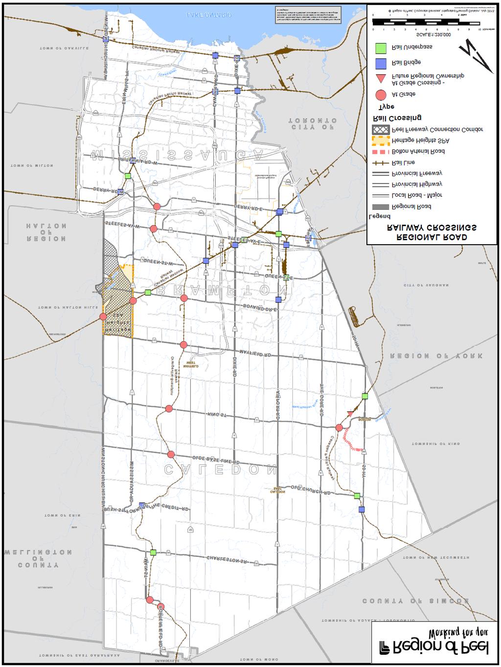
24 Appendix A Map of Rail Crossings on Regional Roads 19
25 20
26 Appendix B Crossing Profile Details 21

27 Crossing Profiles The following profiles have been created for the four crossings to give context to the at-grade rail crossings that Regional staff feels warrant closer consideration for prioritization. Documentation of the forecasting method and other analyses can be found in Appendix c. KING STREET BETWEEN HUMBER STATION ROAD AND HARVEST MOON DRIVE IN CALEDON Figure B-1: King Street between Humber Station Road and Harvest Moon Drive, Caledon (Source: Google maps) King Street CP Rail Line Coleraine Drive Crossing Characteristics Intersecting King Street between Humber Station Road and Harvest Moon Drive in Caledon, this Canadian Pacific Railway line sees an average of 16 freight trains daily, moving at an average speed of 40km/hr. Of all the at-grade rail crossings occurring on Regional roads, this crossing has seen the highest collision rate, with 7 collisions occurring between 2007 and None of the collisions were with a train, all occurred in the daylight hours and the majority (6 out of 7) were rear-end collisions. This indicates that the automatic gates and flashing lights used at this crossing to warn drivers of oncoming trains are sufficient in protecting pedestrian safety. 22

28 Land Use The land surrounding this crossing is currently designated as industrial/commercial and will remain industrial/commercial into the future. The Western side of Coleraine Drive has been proposed for the Bolton Employment Expansion Area by the Town of Caledon, which will have industrial and commercial uses. In June 2013 the Provincial government approved the location of a Canadian Tire warehouse and distribution centre at the corner of Coleraine Drive and Healey Road (just south of the crossing), which could increase truck volumes on Highway 50 and surrounding areas. While this crossing falls within the Bolton Residential Expansion Study Area, based on the preliminary report, it is not anticipated that the expansion area will be located in close proximity to the crossing since Option 1 and 3 have been chosen for further study (see figure below). As a result, limited vehicular impact is expected. It is important to note that there are concerns about the movement of paramedic vehicles from the paramedic station east of the track to residential areas west of the track. Figure B-2: The Bolton Residential Expansion Study Area (Source: Town of Caledon) Goods Movement In terms of goods movement, King Street is intended to be a primary truck route under the Strategic Goods Movement Network (SGMN), with connectors to Highway 50 and the future planned Bolton Arterial Road (BAR). The BAR is planned to be complete in 2015 and will act as a goods movement route, by-passing the Bolton community. With the presence of the BAR just east of the crossing and the designation of King Street as a primary goods movement road, it is anticipated that there will be significant truck traffic flow in this area. Other The Bolton Commuter Rail Service feasibility study has been completed and was released by GO Transit in Findings indicate that rail service between Bolton and Union Station is technically feasible based on estimated population and employment growth, with ridership projected to reach 4,400 daily by The feasibility study identified the preferred station location to be at the intersection of King Street and Humber Station Road, which is in close proximity to both the King 23
29 Street and Coleraine Drive crossings. While originally included in MoveOntario 2020 (which subsequently became the Big Move), Metrolinx has not included the Bolton commuter rail within the first or second wave of projects. While no work is expected to occur prior to 2031 on the Bolton commuter line, it is important to consider the increased vehicular traffic as well as train volumes that would be associated with it. Growth Forecast In order to forecast growth in the Bolton area, which includes both the at-grade crossings at King Street and Coleraine Drive, population, employment, historical traffic trends and impacts of new developments and land use changes were considered. Population from the surrounding traffic super zones was analyzed in order to calculate a population growth rate for the area. Likewise, super zones for the airport and those on the east border of Peel, between Bolton and the airport, were selected in addition to the surrounding areas to calculate the employment growth rate. Due to its location close to the Peel border, interregional traffic was also a consideration. Since Vaughan and Planning District 9 in Toronto also have industrial lands that will experience growth in the future, they were included in the analysis due to their proximity and connections with the Bolton area. The Canadian Pacific Intermodal Terminal in Vaughan is located just a few kilometers from Peel s border as well, which is a major generator of truck traffic. A summary of the growth percentages calculated is shown in Table B-1 below. In addition to the increase in traffic from population and employment growth as planned by the Residential Expansion Study and the industrial expansion in the Bolton Area, the construction of the BAR will also change the way King Street is utilized since the BAR acts as a bypass for the Rural Service Centre of Bolton, making it much more convenient for trucks to travel via this area in the future. Table B-1: Annual Growth Rates Calculated for the Bolton Area Period of Growth 2011 to to 2031 Annual Growth Rate 4.5% 3% The traffic volume projections for King Street yielded a volume of approximately 17,000 daily vehicles, in total for both directions in This is more than double the volume experienced on King Street today. Approximately 1,600 trucks can be expected on a daily basis in this area for 2031 based on the existing truck volume percentages, as shown in Table B-2. If road capacity remains the same, with no separation, congestion may be diverted to nearby roads. Table B-2: Summary of Current and Projected Average Annual Daily Traffic (AADT) Volumes for the King Street At-Grade Crossing Type of Traffic Current E/W AADT Projected 2021E/W Projected 2031E/W AADT AADT All 8,300 13,000 17,000 Truck 800 1,200 1,600 According to the exposure index established by Transport Canada, for the purposes of prioritizing grade separation of at-grade rail crossings, the threshold at which grade-separation is recommended, 200,000 points, will be reached in less than 10 years if the frequency of trains remains at 16 per day. Given the lack of available data train volumes for 2031 were not predicted, implying that this threshold may be reached earlier. Another factor affecting the truck traffic in this area is the nature of the railway line. Since this railway corridor is a primary Canadian Pacific Railway line, it experiences significantly higher train 24
30 volumes, especially when compared to the Orangeville-Brampton Railway (OBRY) line, and is expected to grow and continue to be an important link in the Canadian railway network. The speed at which the trains travel is dependent on the tracks and track classification (17). The operating speed for all trains throughout this section is 25mph (40km/hr) since it is only used by freight trains, which have a slower operating speed than passenger trains. At a maximum train length of about 3,700m, the delay caused by each train could be up to 6 minutes, totaling 100 minutes a day due to 16 daily trains at each at-grade rail crossing in this area. COLERAINE DRIVE BETWEEN ELLWOOD DRIVE W AND MANCHESTER COURT IN CALEDON (REFER TO FIGURE B-1) Crossing Characteristics Located on Coleraine Drive between Ellwood Drive West and Manchester Court on the CP line this crossing is currently not on a Regional road (refer to Figure 1). However, through the ARRASC process, Coleraine Drive will be uploaded to the Region from the Town of Caledon by 2014 and the Region will assume responsibility for it. This crossing sees an average of 16 freight trains daily, moving at an average speed of 40km/hr. Between 2007 and 2011 there were two collisions at the railway crossing, none involving a passing train. It is important to note that in 2012 there was a collision with a train however it was due to the fact that the driver drove around the protective gates when they were down in an attempt to pass the train. Land Use The crossing falls between residential and employment lands. Like the crossing located on King Street, just to the north-west, the most significant land use impact in the area is the new Canadian Tire distribution centre and other planned commercial industrial uses. This crossing also falls within the Bolton Residential Expansion Study Area but will not be in close proximity to the selected expansion area (1 and 3) (Refer to Figure 2 for more detail). Finally, it is important to note that Coleraine Drive is proposed for the Bolton Employment Expansion Ares which could impact the number of vehicles passing through the crossing. Goods Movement This portion of Coleraine Drive is classified as a primary truck route in the SGMN with connections to Highway 50, the BAR and the planned GTA West corridor. The GTA West corridor, which is to run east-west through the northern portion of Peel, is still in its planning stage but will be complete in With the primary route designation and the presence of planned goods movement corridors, it is anticipated that there will be significant truck flows in this area. Other Similar to the crossing at King Street, it will be important to consider the impact of the increased vehicular traffic as well as train volumes that would be associated with it the Bolton commuter line on the flow of goods around this crossing. Growth Forecast The rate of growth in traffic for the Coleraine at-grade rail crossing is the same as that on King Street due to the close proximity of their locations in the Bolton area. In order to forecast the increase in traffic at this at-grade rail crossing, the population of the surrounding areas was considered, in addition to the economic growth rate. This was calculated based on the corridors of goods movement that connect to Bolton, including Planning District 9 in Toronto, and the City of Vaughan due to the Canadian Pacific Railway Intermodal Terminal. Other relevant industrial hubs such as the airport in Peel were also used in the analysis. In Bolton, the employment and residential expansion plans play a major role in the future traffic patterns for this area. Table B-1 (shown above) shows the growth rate calculated for this area and 25
31 Table B-3 below summarizes the traffic projections for truck and vehicular traffic. There are 1,600 trucks expected to use Coleraine Drive daily by in 2031, out of a total daily traffic volume of 22,000 for both directions combined. These volumes are twice the volumes experienced on Coleraine Drive today, and are representative of the impact of the BAR. Table B-3: Summary of Current and Projected Average Annual Daily Traffic (AADT) Volumes for the Coleraine Drive At-Grade Crossing. Type of Traffic Current E/W AADT Projected 2021E/W Projected 2031E/W AADT AADT All 11,100 17,000 22,000 Truck 800 1,200 1,600 It should be noted that the King Street and Coleraine Drive rail crossings are both going to reach the threshold for grade separation set by Transport Canada in less than 10 years, at which point separation is strongly recommended. As mentioned for the at-grade crossing at King Street, the train volumes, lengths and speed at this crossing on Coleraine Drive can cause a maximum total delay of up to 100 minutes daily. 26

32 WINSTON CHURCHILL BOULEVARD BETWEEN WANLESS DRIVE AND ADAMSON STREET N IN BRAMPTON Figure B-3: Winston Churchill Boulevard between Wanless Drive and Adamson Street N, Brampton (Source: Google Maps) Winston Churchill Boulevard CN Rail Line Crossing Characteristics The at-grade rail crossing located on Winston Churchill Boulevard between Wanless Drive and Adamson Street N in Brampton is owned by the Canadian National Railway. This line, which is used for both freight and passenger (VIA Rail and GO Transit) trains, sees approximately 31 trains daily. The VIA passenger trains travel at an average speed of 113km/hr while the GO Trains travel at a slower speed (93km/hr). The freight trains move at about 88km/hr. There were no collisions reported at this crossing. Land Use This crossing falls within a residential neighborhood with greenbelt lands to the west, in Halton. It is also on the boarder of the Heritage Heights planning area, which is made up of Secondary Plan 52 and 53. Through the Preliminary Concept report for Heritage Heights, Winston Churchill Boulevard is slated to be a character road in order to respect the greenbelt lands in Halton Hills. The intention is to have the north-west portion of Winston Churchill Boulevard blend in with high density design by having cycling paths, walking trails, trees and bushes on either side of the road. This indicates that this road will not see significant goods movement but should anticipate higher pedestrian volumes. It is also important to note that, as indicated in Schedule A of Brampton s Official Plan, this crossing is located in the North West Brampton Urban Development Area, which 27
33 is intended for high density development to accommodate growth. As a result, GO train service on the tracks, which is currently run during rush hour times, will increase and could impact traffic flow in the future. Goods Movement The stretch of Winston Churchill in Brampton is not included in the SGMN, and as such major truck flows are not anticipated. Further, it is anticipated that in the future, with the completion of the GTA West and BramWest Parkway, trucks will opt for those roads rather than Winston Churchill Boulevard. This crossing may not require separation to meet the future needs of goods movement, but rather for pedestrian safety. Other The Region has developed the Road Improvement Program with the goal of maintaining safe and efficient roads. Within it, Winston Churchill Boulevard between Mayfield Road and just north of Bovaird Drive is scheduled for a road improvement by As part of that improvement, additional safety measures for pedestrians at the crossing should be considered. Growth Forecast The growth in traffic at Winston Churchill Boulevard was calculated in a similar way to the crossings mentioned previously. The growth rate was calculated by selecting the bordering Traffic Super Zones and analyzing the increase in population and employment over time, until The Halton area was not considered in this analysis since it is not expected to contribute to traffic significantly due to lower intensification targets. The Bramalea and airport super zones were included in addition to the surrounding areas for the employment growth rate calculation. The Bramalea super zone is connected to the area around this crossing well, via Bovaird Drive West, and the growth in employment in the airport super zone may have an impact in this area. Further, historical traffic trends were analyzed using ATR data and were also considered in the growth rate, summarized in Table B-4 below. Due to the Heritage Heights preliminary concept report and the planned BramWest Parkway, Winston Churchill Boulevard may be given the status of a character road in the future. This creates the possibility that BramWest Parkway, which will have a connection to the GTA West highway in the future, will primarily carry the industrial traffic for this area. It should be noted that the forecasts below in Table B-5 are therefore for the roads in that general area, and not necessarily Winston Churchill Boulevard alone. Table B-4: Annual Growth Rate for the Winston Churchill Blvd. At-Grade Crossing Area Period of Growth 2011 to to 2031 Annual Growth Rate 5% 3% Table B-5: Summary of Current and Projected Average Annual Daily Traffic (AADT) Volumes for the Winston Churchill Boulevard At-Grade Rail Crossing. Type of Traffic Current E/W AADT Projected 2021E/W Projected 2031E/W AADT AADT All 2,400 4,000 5,000 Truck
34 At 31 trains per day and growing, the projected daily traffic volume of 5,000 vehicles in 2031 is well below the threshold at which grade separation is recommended. The railway line that crosses Winston Churchill Boulevard here is a main line for Canadian National Railway, however, unlike the crossing at King Street and Coleraine Drive, it carries passenger trains in addition to freight. The speeds at which passenger trains and freight trains move is significantly different, as are the lengths of the trains. Fourteen out of 31 trains are passenger trains on this line, and passenger trains are shorter (at 10 cars) and also move much faster, taking barely a minute to cross if travelling at the maximum speed. Similar to the Canadian Pacific line near Bolton, 17 freight trains use this line per day, however due to the class of the tracks, they travel at more than double the speed, causing shorter delays on the road. The total maximum delay per day for this crossing is 59 minutes, slightly more than half of the crossings in the Bolton area. BOVAIRD DRIVE BETWEEN VAN KIRK DRIVE AND GILLINGHAM DRIVE IN BRAMPTON Crossing Characteristics The crossing located at Bovaird Drive between Van Kirk Drive and Gillingham Drive in Brampton is owned by the OBRY. As mentioned earlier, on average only one train crosses this track daily and serves primarily a tourist function with some freight movement. The average speed of the trains using these tracks is approximately 40km/h. Between 2007 and 2011, four collisions occurred at this crossing and none were with a train. Land Use This crossing falls within industrial/commercial lands and will remain industrial/commercial into the future with additional industrial uses expected along Bovaird Drive. Goods Movement Bovaird Drive is classified in the SGMN as a primary truck route. It currently has the highest vehicular volumes of any crossing in Peel Region. Other It is important to note that when members of the Ontario Trucking Association were surveyed, they indicated that this crossing was problematic. Due to the fact that there is low train frequency, it can be deduced that the issues related more to the crossing surface than the delay associated with passing trains. This portion of road is also scheduled for road improvements by 2023, as indicated in the Region s Long Range Transportation Plan. It will be important to consider the role of the crossing surface in the efficiency and safety of trucks and vehicles passing it at that time. Figure B-4: Bovaird Drive between Van Kirk Drive and Gillingham Drive, Brampton Source: (Google maps) 29

35 OBRY Line Bovaird Drive West Growth Forecast For both the population and employment growth rate calculations, the Traffic Super Zones bordering the area of this at-grade rail crossing on Bovaird Drive West were included in the analysis. For the employment growth rate, the airport super zone was included in addition to the surrounding areas, as with all other crossings. A summary of the growth rates calculated is in Table B-6 below. ATR data was used to study historical traffic growth, and a consistent increase in volumes was anticipated. The growth rates calculated for this area closely match this historical increase in traffic. Table 11 below summarizes the projected traffic volumes. Since Bovaird Drive West is already a 6-lane road, further widening of this corridor is unlikely based on current Regional practices, therefore traffic patterns will change once congestion levels increase on this road. Mayfield Road may be a potential alternative for many future origins and destinations in this area. As such, the volumes listed in Table B-7 will not be achieved on Bovaird Drive West alone, but will be dispersed as other communities and roads develop in the vicinity of this crossing. 30
36 Table B-6: Annual Growth Rates for the Bovaird Drive West At-Grade Crossing Area Period of Growth 2011 to to 2031 Annual Growth Rate 4% 2.5% Table B-7: Summary of Current and Projected Average Annual Daily Traffic (AADT) Volumes for the Bovaird Drive West At-Grade Rail Crossing. Note that these volumes will not be accommodated on Bovaird Drive West under the current capital improvement plan, and represent the growth for that general area instead. Type of Traffic Current E/W AADT Projected 2021E/W Projected 2031E/W AADT AADT All 46,700 69,000 89,000 Truck 4,800 7,000 9,000 At approximately just over one train per day in the future, the projected daily traffic volume of 89,000 vehicles in 2031 is well below the threshold at which grade separation is recommended. Given that the use of this railway line is limited to recreational passenger trains and some freight, the lengths of these trains is quite short and crossing time is anticipated to be about 1.3 minutes per train, just once a day. Delays to goods movement due to the rail crossing are therefore not significant in this area. 31
37 Appendix C Detailed Calculations 32
38 1.0 TRAFFIC VOLUME MEASUREMENT The two primary forms of data used in calculations to evaluate the at-grade rail crossings were Average Annual Daily Traffic (AADT), conveying vehicular traffic volumes per day, and Automatic Traffic Recorder (ATR) data, to gather information on the ratio of trucks and cars using the road of interest. These two types of data are described and discussed further below. 1.1 Automatic Traffic Recorder (ATR) Data Automatic Traffic Recorders collect data on how many vehicles use a particular roadway over a 24-hour period. ATR counts also provide information on the type and speed of vehicles (22). ATR also provides hourly traffic data, which is useful in order to gauge level of congestion during the peak hours of travel. Data is collected by using rubber tubing that is stretched across a roadway and connects to a counting device. There are approximately 232 ATR stations in Peel Region (22). For the purpose of this study, 2011 ATR data was used for Peel Regional roads, and 2012 data was used for Coleraine Drive. Adjustments in calculations were made as appropriate in order to account for the difference for the one year difference. 1.2 Average Annual Daily Traffic (AADT) Data Annual Average Daily Traffic is a calculation of the total number of vehicles that pass a certain place in an average weekday of the year. AADT measurements are based on the data collected using Automatic Traffic Recorders (22). 1.3 Preliminary Analysis AADT and ATR data was used at the initial stage of the study in order to gain information on the busiest Regional roads used for passenger travel and goods movement. For the purpose of this study, the total volume crossing each road-rail intersection was noted, i.e. the combined volumes for east and west, or north and south, travel. ATR vehicle classification data was used for deriving the truck volume passing each at-grade rail intersection at the closest location possible. These AADT and ATR stations are noted on each intersection profile in chapter 4. Trucks are those vehicles classified from Class 5 to Class 13 in the Federal Highway Administration (FHWA) Vehicle Classification Scheme F Report (23). This is the Regional standard of measurement for truck volumes in the various Transportation groups at Peel. The percentage of truck volume out of the total volume of traffic, as well as the corresponding truck volumes were used in the preliminary analysis using ATR data, in addition to the AADT. The relationship between these three pieces of data can be described as follows: V trucks = % truck volume x V all traffic 33
39 Where: V trucks = volume of truck traffic in trucks/day throughout the day % truck volume = percentage of truck volume out of total traffic volume in the day V all traffic = total traffic volume, including trucks, in vehicles/day Due to the nature of the data, there may be fluctuations in the volumes. This can be attributed due to many factors weather, road condition, sampling error, equipment condition, or even human error. For this reason, the traffic volumes have been rounded to 3 significant figures, and less where there are lower volumes present. The Exposure Index (EI), which is sometimes referred to as the cross product, was then calculated using these numbers, providing an approximate ranking for all at-grade rail crossings in Peel. Based on the literature review mentioned previously in section 2.2 of the document, the method for calculation the exposure index is described below. EI = (V all road traffic )(V train ) Where: V all road traffic = volume of all traffic, including automobiles and trucks in vehicles/day V train = volume of trains in trains/day This exposure index was applied to forecasted traffic volumes as well, in order to estimate when the threshold for grade-separation, as set by Transport Canada at 200,000 points, would be reached. It should be noted that no forecasts were done for train volumes, but the respective railway owners have indicated that growth in daily train volumes can be expected. 2.0 TRAFFIC VOLUME FORECASTS In order to account for future growth in traffic, and land use changes that can trigger changes in travel patterns, traffic volumes and associated increases in truck volumes were forecasted using growth projections. Existing population and employment data was used to project an annual growth percentage for a particular geographical area, which was then applied to the AADT and truck volumes in order to estimate the volumes in the future. Current and future land designation also played an important role in this process. Hourly data for the AM peak period was used from the ATR data in order to project congestion levels in the future, by comparing future volume with the future capacity resulting from planned road widening and capital investments. ATR data from previous years was also analyzed, however, with the new developments and evolving land uses in Peel, it may not be a reliable indicator for the future since the construction of new roads, among other changes, cannot be accounted for through this method of forecasting. The data was only used to contribute to the growth rate where applicable, based on professional judgment. 34
40 2.1 Exponential Growth The standard at the Region of Peel is to assume that an exponential growth rate best describes the population growth patterns in Peel, therefore all growth calculations have been made accordingly with the same assumption. The derived formula is explained further below. Standard Exponential Growth Equation: X t = X o (1 + r) t where: t = time in years, > 0 X t = population at time t X o = initial population at t = 0 r = growth rate Therefore, the equation to find the annual growth rate, (1 + r), is: (1 + r) = (X t /X o ) (1/t) 2.2 Data by Traffic Super Zones The estimation for the population and employment growth rates was done by utilizing data organized by geography. The Region is divided into Traffic Analysis Zones, which are then aggregated to form Traffic Super Zones (Figure C-1).The boundary for these zones is based on the land use, which is evident by the larger areas in rural Caledon, and smaller areas in urban Mississauga. The description of each super zone can be found in Table C-1. The most up-to-date forecasted population and employment numbers were calculated in 2009, for years 2011, 2021 and
41 Table C-1: Labels of Traffic Super Zone 1 Bolton 2 Mayfield West 3 Caledon S. 22 Commercial 23 Streetsville 24 Meadowvale 4 Caledon E. 5 Caledon N. 6 Caledon Village 7 Brampton E. 8 Bramalea 9 Downtown Brampton 10 Brampton W. 11 Wildfield 12 Snelgrove 13 Castlemore 14 NW Brampton 15 Port Credit 16 Clarkson 17 Applewood 18 Downtown Mississauga 19 Goodville 20 Erin Mills 21 Airport 36

42 At-Grade Rail Separation Study for Regional Roads Figure C-1: Map of Traffic Super Zones for the Region of Peel. 37
To provide an update on the progress of the Peel Goods Movement Task Force and the Peel Goods Movement Strategic Plan.
 9.2-1 REPORT Meeting Date: 2015-11-26 Regional Council For Information DATE: November 10, 2015 REPORT TITLE: REGION OF PEEL GOODS MOVEMENT STRATEGIC PLAN - 2015 STATUS UPDATE FROM: Dan Labrecque, Commissioner
To provide an update on the progress of the Peel Goods Movement Task Force and Peel Goods Movement Strategic Plan.
 8.4-1 REPORT Meeting Date: 2014-06-26 Regional Council For Information DATE: June 17, 2014 REPORT TITLE: PEEL GOODS MOVEMENT STRATEGIC PLAN UPDATE 2014 FROM: Dan Labrecque, Commissioner of Public Works
Sabbir Saiyed, PhD., P.Eng. Manager, Transportation System Planning
 Sabbir Saiyed, PhD., P.Eng. Manager, Transportation System Planning February 5, 2016 Goods Movement is a Major Part of Peel s Economy Peel is one of Canada s most important freight hubs Close to major
Niagara Region Transportation Master Plan Niagara-Hamilton Trade Corridor Technical Paper
 Niagara-Hamilton Trade Corridor Technical Paper 1. Purpose In the report to Council on the Regional Council Strategic Priorities Implementation Plan, pursuing Provincial commitment for the Niagara to Greater
GTA West Corridor Environmental Assessment. Executive Summary - November Transportation Development Strategy Report
 GTA West Corridor Environmental Assessment Transportation Development Strategy Report Executive Summary - November 2012 GTA West Corridor Environmental Assessment Executive Summary 1 Table of Contents
3. SYSTEM ANALYSIS Future (2031) AADT and SADT Estimates
 AADT and SADT Estimates") 3. SYSTEM ANALYSIS 3.1 Congestion Analysis As indicated in Section 2.1, a key component of the GTAW Corridor Planning and Environmental Assessment Study is the assessment of the inter-regional travel demands
3. SYSTEM ANALYSIS 3.1 Congestion Analysis As indicated in Section 2.1, a key component of the GTAW Corridor Planning and Environmental Assessment Study is the assessment of the inter-regional travel demands
3. STATION SPACING AND SITING GUIDELINES
 3. STATION SPACING AND SITING GUIDELINES The station spacing and siting guidelines are summarized in Table 3-1. Table 3-1 also includes benchmark information for local transit service and express bus as
City of Brantford Chapter 3 TABLE OF CONTENTS
 Chapter 3 The Land Use & Transportation Connection TABLE OF CONTENTS 3.1 THE LAND USE & TRANSPORTATION LINK... 1 3.2 POPULATION & EMPLOYMENT GROWTH FORECASTS... 3 3.2.1 Proposed Places to Grow Plan Forecasts
Niagara s Transportation Strategy 1. Introduction:
 Niagara s Transportation Strategy May 8, 2002 Niagara s Transportation Strategy 1. Introduction: Transportation is of pivotal importance in the development of Niagara. This, Niagara s first comprehensive
GTA West Corridor Environmental Assessment Study. Transportation Development Strategy Report - November 2012
 GTA West Corridor Environmental Assessment Study Transportation Development Strategy Report - November 2012 Table of Contents Executive Summary - Under Separate Cover 1. INTRODUCTION...1 1.1. STUDY BACKGROUND...1
PLANNING 2005 SERVICE STRATEGY BUSINESS PLAN
 TABLE OF CONTENTS A. Background A.1 Preparing the Service Strategy Business Plan... 1 A.2 Key Contacts... 1 A.3 Additional Information... 1 B. Description of Current Services B.1 Program Location Map...
DESIGN AND CONSTRUCTION OF DERRY ROAD AND CANADIAN NATIONAL RAIL GRADE SEPARATION
 DESIGN AND CONSTRUCTION OF DERRY ROAD AND CANADIAN NATIONAL RAIL GRADE SEPARATION Vireak Hinh, P.Eng. R.V. Anderson Associates Ltd., Toronto, Canada Jennifer Trimble Region of Halton, Oakville, Canada
407 TRANSITWAY. Planning & Preliminary Design
 FROM EAST OF HIGHWAY 400 TO KENNEDY ROAD GWP #252-96-00 Public Information Centre #2 June 24 th and 29 th, 2010 Purpose of Public Information Centre #2 The first Public Information Centre (PIC #1) was
Mobility and System Reliability Goal
 Mobility and System Reliability Goal Provide surface transportation infrastructure and services that will advance the efficient and reliable movement of people and goods throughout the state. Background:
Transit Service Guidelines
 G R E AT E R VA N CO U V E R T R A N S P O RTAT I O N A U T H O R I T Y Transit Service Guidelines PUBLIC SUMMARY REPORT JUNE 2004 Greater Vancouver Transportation Authority TRANSIT SERVICE GUIDELINES
Intelligent Transportation Systems Master Plan
 Space Coast Transportation Planning Organization Intelligent Transportation Systems Master Plan April 15, 2014 Version 1.0 Prepared for: Space Coast Transportation Planning Organization 2725 Judge Fran
3.6 GROUND TRANSPORTATION
 3.6.1 Environmental Setting 3.6.1.1 Area of Influence The area of influence for ground transportation consists of the streets and intersections that could be affected by automobile or truck traffic to
Graydon-Banning / Shevchenko (NORTH OAKVILLE)
") Graydon-Banning / Shevchenko (NORTH OAKVILLE) Tree Canopy Coverage Analysis Prepared by: NAK Design Strategies Prepared for: Martillac Estates Inc. September 9, 2016 02 GRAYDON-BANNING/SHEVCHENKO NORTH
Graydon-Banning / Shevchenko (NORTH OAKVILLE) Tree Canopy Coverage Analysis Prepared by: NAK Design Strategies Prepared for: Martillac Estates Inc. September 9, 2016 02 GRAYDON-BANNING/SHEVCHENKO NORTH
GO RAIL NIAGARA SERVICE EXTENSION
 Business Case: Finch Avenue West Rapid Transit GO RAIL NIAGARA SERVICE EXTENSION INITIAL BUSINESS CASE Date: November, 2014 NOVEMBER 2015 Page 1 TABLE OF CONTENTS 1.0 Executive Summary...p.5 2.0 Introduction....p.6
TOWN OF MILTON. Transit Master Plan MOVING MILTON FORWARD
 TOWN OF MILTON Transit Master Plan 2013-2017 MOVING MILTON FORWARD Appendix B - Strategic Plan Working Paper February 2013 Town of Milton Moving Milton Forward Transit Master Plan Strategic Plan Working
Building for Prosperity: Public Infrastructure in Ontario
 Building for Prosperity: Public Infrastructure in Ontario July 2012 Minister s Message Safe, modern and efficient public infrastructure is key to Canada s economic growth and long-term prosperity. Knowing
APPENDIX 2 GO Regional Express Rail 10-Year Program: New Stations Analysis. Board of Directors Report June 28, 2016
 APPENDIX 2 GO Regional Express Rail 10-Year Program: New Stations Analysis Board of Directors Report June 28, 2016 2 Defining RER The Vision RER 10-Year Program and New Stations Objectives of New Stations
THAT Council adopt the Congestion Management Strategy as outlined in this report
 RR3 ADMINISTRATIVE REPORT Report Date: May 2, 2017 Contact: Winston Chou Contact No.: 604.873.7913 RTS No.: 011564 VanRIMS No.: 08200020 Meeting Date: May 16, 2017 TO: FROM: SUBJECT: Vancouver City Council
APPENDIX B. Public Works and Development Engineering Services Division Guidelines for Traffic Impact Studies
 APPENDIX B Public Works and Development Engineering Services Division Guidelines for Traffic Impact Studies Revised December 7, 2010 via Resolution # 100991 Reformatted March 18, 2011 TABLE OF CONTENTS
Milton and CN A Partnership
 DID-5-15 APPENDIX A Milton and CN A Partnership Milton and CN A Partnership March 2014 0 Milton and CN CN has been in Milton for more than 100 years Our rail line runs through the community, carrying a
1 RICHMOND HILL CENTRE / LANGSTAFF URBAN GROWTH CENTRE - TRANSPORTATION STUDY
 Report No. 4 of the Transportation Services Committee Regional Council Meeting of April 22, 2010 1 RICHMOND HILL CENTRE / LANGSTAFF URBAN GROWTH CENTRE - TRANSPORTATION STUDY The Transportation Services
FREIGHT CORRIDORS AND GATEWAYS: DEVELOPMENT APPROACH AND EVALUATION CRITERIA COMPARISON IN NORTH AMERICA AND THE EUROPEAN UNION
 FREIGHT CORRIDORS AND GATEWAYS: DEVELOPMENT APPROACH AND EVALUATION CRITERIA COMPARISON IN NORTH AMERICA AND THE EUROPEAN UNION Juan Carlos Texas A&M Transportation Institute Introduction International
6.2.2 Environmental Consequences and Mitigation Measures
 6.2 6.2.1 Introduction The existing conditions, regulatory setting, and methods of analysis for transportation under CEQA are described in Chapter 3, NEPA and CEQA Analysis. Impacts that would result from
E X E C U T I V E S U M M A R Y BUSINESS CASE. - June CAMBRIDGE ON THE GO BUSINESS CASE page 1
 E X E C U T I V E S U M M A R Y BUSINESS CASE - June 2015 CAMBRIDGE ON THE GO BUSINESS CASE page 1 E X E C U E T X I E V C E U S T U I V M E M S A U R M Y M A R Y EXECUTIVE SUMMARY The partnering communities
NORTH I-75 MASTER PLAN Summary Report
 NORTH I-75 MASTER PLAN Summary Report Interstate 75 (SR 93) From the Florida s Turnpike Interchange to the I-10 Interchange Alachua, Bradford, Clay, Citrus, Columbia, Duval, Levy, Marion, and Sumter Counties,
The Policies section will also provide guidance and short range policies in order to accomplish the goals and objectives.
 4 Goals & Objectives INTRODUCTION The 2015-2040 MTP preserves and promotes the quality of life and economic prosperity of the MAB by providing a transportation system consistent with the regional goals.
Transportation and Works Department The Regional Municipality of York Yonge Street Newmarket, Ontario L3Y 6Z1
 TRANSPORTATION IMPACT STUDY (TIS) GUIDELINES FOR DEVELOPMENT APPLICATIONS Transportation and Works Department The Regional Municipality of York 17250 Yonge Street Newmarket, Ontario L3Y 6Z1 August, 2007
St. Stephen Calais Border Crossing Study Preliminary Assessment of Options. Table of Contents. 1.0 Background Information and Project Rationale...
 Table of Contents Page 1.0 Background Information and Project Rationale..... 1 2.0 Corridor Descriptions. 2 2.1 Option 2A: [Baileyville Option].. 2 2.2 Option 3: [Calais Industrial Park Option] 3 3.0 Preliminary
NORTHWEST GREATER TORONTO AREA INTEGRATED REGIONAL RESOURCE PLAN. Part of the GTA West Planning Region April 28, 2015
 NORTHWEST GREATER TORONTO AREA INTEGRATED REGIONAL RESOURCE PLAN Part of the GTA West Planning Region April 28, 2015 Integrated Regional Resource Plan Northwest Greater Toronto Area Sub-Region This Integrated
Draft Regional Transportation Plan Comments
 Draft Regional Transportation Plan Comments Pembina Institute s submission to Metrolinx 1 by Nithya Vijayakumar and Lindsay Wiginton November 15, 2017 Summary Metrolinx s draft Regional Transportation
2030 Transportation Policy Plan SUMMARY PRESENTATION. Land Use Advisory Committee November 15, 2012
 2030 Transportation Policy Plan SUMMARY PRESENTATION Land Use Advisory Committee November 15, 2012 Today s Topics Transportation Policy Plan (TPP) Requirements and Background Current TPP Policies, Issues
PLANNING FOR CHILDCARE IN THE GATEWAY DISTRICT NODE: CITY OF MISSISSAUGA
 APPENDIX F APPENDIX G APPENDIX H PROPOSED DRAFT AMENDMENT NO. TO THE OFFICIAL PLAN OF THE REGIONAL MUNICIPALITY OF PEEL 1.0 Statutory Provisions This Amendment No. to the Official Plan for
Jim Alexander Director of Design and Engineering, Southwest Light Rail Transit Project
 Memorandum Date: January 15, 2014 To: CC: From: Subject: Jim Alexander Director of Design and Engineering, Southwest Light Rail Transit Project Paul Danielson, P.E. Project Manager, Southwest Light Rail
Chapter 4: Transportation and Land Use
 Chapter 4: Transportation and Land Use Transportation and land use together make possible the wide range of destination opportunities in the region. Transportation provides the connections, and, in turn,
Factor Potential Effects Mitigation Measures
 Natural Environment No impacts of provincial significance to the natural environment are anticipated for the rapid transit project. Other impacts and how they will be mitigated are outlined in the table
Appendix D: Functional Classification Criteria and Characteristics, and MnDOT Access Guidance
 APPENDICES Appendix D: Functional Classification Criteria and Characteristics, and MnDOT Access Guidance D.1 Functional classification identifies the role a highway or street plays in the transportation
Chapter 3 - Goals, Objectives, & Strategies
 Chapter 3 - This chapter presents goals, objectives, and strategies that have been developed as part of the Richmond Area MPO 2026 Long-Range Transportation Plan (LRTP) update. Strategies have been developed
Appendix M. Noise Assessment
 Appendix M Noise Assessment 610 Chartwell Road, Suite 300 Oakville, ON Canada L6J 4A5 t: 905.823.8500 f: 905.823.8503 www.mmmgrouplimited.com www.wspgroup.ca MEMO RE: FROM: DATE: March 27, 2017 COPIES:
Stockton Freight & Passenger Rail Mobility Enhancement
 Stockton Freight & Passenger Rail Mobility Enhancement 2017 $10.34 million in 2017 FASTLANE Grant funding to complete engineering design, permitting, and construction of the Stockton Track Extension and
Shannon Noonan, City of Cambridge Don Drackley, IBI Group Scott Johnson, IBI Group PTSL
 100 175 Galaxy Boulevard Toronto ON M9W 0C9 Canada tel 416 679 1930 fax 416 675 4620 ibigroup.com Memorandum To/Attention From cc Shannon Noonan, City of Cambridge Don Drackley, IBI Group Scott Johnson,
TRANSPORTATION MOBILITY PLAN GUIDELINES
 TRANSPORTATION MOBILITY PLAN GUIDELINES for Development Applications November 2016 Executive Summary The Regional Municipality of York (the Region) is located in the heart of the Greater Toronto Area (GTA)
RURAL RESIDENTIAL COMMUNITY ROLE COUNCIL ROLE RURAL RESIDENTIAL ALL COMMUNITIES
 Orderly and Efficient Land Use Align land use, development patterns, and infrastructure to make the best use of public and private investment. Discourage future development of rural residential patterns
LAND USE POLICIES BY COMMUNITY DESIGNATION
 137 2040 138 Land Use Policies by Community Designation As discussed earlier in Thrive MSP 2040, the Council assigns a community designation to each city and township. This designation indicates the overall
1RUWKZHVW#:LFKLWD 0DMRU#,QYHVWPHQW#6WXG\
 1RUWKZHVW#:LFKLWD 0DMRU#,QYHVWPHQW#6WXG\ Executive Summary 3UHSDUHGýIRUã 3UHSDUHGýE\ã.DQVDVý'HSDUWPHQWýRI 7UDQVSRUWDWLRQ,QýDVVRFLDWLRQýZLWKã (DUWKý7HFKý,QFï EXECUTIVE SUMMARY Introduction This Northwest
May April 2016 DRAFT. London s Rapid Transit Initiative. Business Case
 May April 2016 London s Rapid Transit Initiative Business Case DRAFT Table of Contents EXECUTIVE SUMMARY...i Economic Environmental Scan iii Key Benefits of London s Rapid Transit Initiative iii Plan
Chapter 10 Goals, Objectives + Policies
 Chapter 10 Goals, + Policies Warehouse on Nestle Way near I-78 114 115 10.1 ESTABLISHMENT OF CONSISTENT GOALS 10.2 NATIONAL FREIGHT GOALS The Lehigh Valley s freight transportation investment decisions
MONITORING IMPLEMENTATION AND PERFORMANCE
 12 MONITORING IMPLEMENTATION AND PERFORMANCE The FAST Act continues the legislation authorized under MAP-21, which created a data-driven, performance-based multimodal program to address the many challenges
CITY OF VANCOUVER ADMINISTRATIVE REPORT. General Manager of Engineering Services in consultation with the Director of Current Planning
 CITY OF VANCOUVER ADMINISTRATIVE REPORT Date: September 1, 2005 Author: Dale Bracewell Phone No.: 604.871.6440 RTS No.: 5291 CC File No.: 8203 Meeting Date: September 20, 2005 TO: FROM: SUBJECT: Standing
3.0 REVIEW OF PREVIOUS STUDIES
 3.0 REVIEW OF PREVIOUS STUDIES This section of the highlights the significant features from previous plans and studies that could impact the development of the I-20 East Transit Initiative. Much of the
Project Initiation Form
 Meeting Date: The Project Initiation Form should be completed in conjunction with the Level 2 Screening Form. Process Leads and/or Planners should complete the Project Initiation Form to document coordination
Master Plan. Summary
 R e g i o n a l Tr a n s p ortat i o n Master Plan Summary Executive Summary With an increasing population and changing demographics, Waterloo Region must ensure that growth is both sustainable and affordable.
Airport Road from 1 km North of Mayfield Road to 0.6 km North of King Street Public Information Centre #1
 Municipal Class Environmental Assessment Airport Road from 1 km North of Mayfield Road to 0.6 km North of King Street Public Information Centre #1 Date: Thursday, June 20, 2013 Time: 6:30 p.m. 8:30 p.m.
- FACT SHEET - THE GUIDING PRINCIPLES
 THE GUIDING PRINCIPLES The General Plan begins with seven ideas that together create a vision for the City s future. When the City approved the General Plan in 1994, these idea were dubbed the Seven Guiding
CDTC NEW VISIONS FREIGHT & GOODS MOVEMENT
 CDTC NEW VISIONS FREIGHT & GOODS MOVEMENT White Paper January 2015 Draft Capital District Transportation Committee One Park Place Albany NY 12205 518-458-2161 www.cdtcmpo.org Contents Introduction... 2
Greater Golden Horseshoe Transportation Plan
 Greater Golden Horseshoe Transportation Plan Transportation Profile November 2017 PREPARED BY Urban Strategies Inc. and HDR for the Ministry of Transportation Prepared by Urban Strategies Inc. and HDR
Governor Baldacci s Transportation Bond Proposal
 Governor Baldacci s Transportation Bond Proposal Talking Points Highway and Bridge Investment The lifeblood of the Maine economy $100 HF Bond Maine s Bridges are old and getting older - Nearly 10% are
Local Planning for Goods Movement in Ontario
 Local Planning for Goods Movement in Ontario A survey of current municipal practices and opportunities Lindsay Wiginton Photo: Rachel Brown for the Pembina Institute October 2017 Local Planning for Goods
TRAFFIC STUDY GUIDELINES
 TRAFFIC STUDY GUIDELINES December 2013 The scope of the traffic impact analysis (TIA) should follow these guidelines and the requirements of VMC 11.80.130 and VMC 11.70, transportation concurrency (attached
Draft Noise Abatement Guidelines
 Document under Separate Cover refer to IMLC01-13 Draft Noise Abatement Guidelines April 2013 Legislative & Planning Services Table of Contents 1.0 Introduction...1 1.1 Key Definitions...1 2.0 Existing
2016 transit accessibility plan
 2016 transit accessibility plan This document is available in alternate formats upon request. 905-864-4141 transit@milton.ca miltontransit.ca Table of Contents Section 1 Executive Summary 3 Section 2 Milton
RER New Stations Initial Business Case BRESLAU STATION. Kitchener Corridor. July Draft
 RER New Stations Initial Business Case BRESLAU STATION Kitchener Corridor July 2016 Draft Draft: v1.2 Metrolinx RER New Stations Initial Business Case BRESLAU Draft Prepared by: IBI Group 55 St. Clair
LAS VEGAS STREET RAILROAD CROSSING RR/PUC CONNECTION AND PRELIMINARY DESIGN
 LAS VEGAS STREET RAILROAD CROSSING RR/PUC CONNECTION AND PRELIMINARY DESIGN Prepared for: City of Colorado Springs Prepared by: Felsburg Holt & Ullevig 508 South Tejon Street Colorado Springs, CO 80903
Project Evaluation Criteria
 Project Evaluation Criteria Goals and Objectives were developed to guide Envision 35 Long Range Transportation Plan (LRTP) Update. These guiding principles were based on the requirements included in the
THE REGION S PLAN POLICY FRAMEWORK. August 2015
 THE REGION S PLAN POLICY FRAMEWORK August 2015 2 What is The Policy Framework? Cover photo credit: Sinan Sinharoy for Atlanta BeltLine, Inc. Atlanta is one of the world s most dynamic metropolitan areas,
2018 transit accessibility plan DRAFT
 2018 transit accessibility plan Table of Contents Section 1 Executive Summary 3 Section 2 Milton Transit Services Profile 4 Conventional Service 2017 Service Profile 4 Specialized Service 2017 Service
Congestion Management Process 2013 Update
 OVERVIEW OF THE DALLAS-FORT WORTH CONGESTION MANAGEMENT PROCESS Traffic Congestion In The Dallas-Fort Worth Region With the Dallas-Fort Worth (DFW) urban area as its center, the North Central Texas region
COMPREHENSIVE PLAN Executive Summary C ITY OF ENNIS, TEXAS
 COMPREHENSIVE PLAN 2000-2020 Executive Summary CITY OF ENNIS, TEXAS COMPREHENSIVE PLAN 2000 2020 EXECUTIVE SUMMARY! The Future Land Use Plan! Public Facilities Plan (Map) Table of Contents! Parks, Recreation
General Guidelines for the Preparation of Traffic Impact Studies
 ENGINEERING & OPERATIONS DIVISION General Guidelines for the Preparation of Traffic Impact Studies April 2010 Prepared by: Highway Planning and Design Branch Table of Contents 1. INTRODUCTION 1 2. TRAFFIC
Memorandum. FROM: Jim Ortbal Rosalynn Hughey Barry Ng TO: HONORABLE MAYOR, CITY COUNCIL. DATE: June 16, 2017
 CITY OF SANjOSE CAPITAL OF SILICON VALLEY TO: HONORABLE MAYOR, CITY COUNCIL SUBJECT: TRANSPORTATION POLICY UPDATE REQUIRED BY STATE LAW - LOS TO VMT Memorandum FROM: Jim Ortbal Rosalynn Hughey Barry Ng
ENVIRONMENTAL IMPACTS OF TRANSPORTATION TO THE POTENTIAL REPOSITORY AT YUCCA MOUNTAIN
 ENVIRONMENTAL IMPACTS OF TRANSPORTATION TO THE POTENTIAL REPOSITORY AT YUCCA MOUNTAIN R.L. Sweeney, USDOE Yucca Mountain Project; R. Best, Jason and Associates; P. Bolton, P. Adams, Booz-Allen & Hamilton
Transit, Intercity Bus, Taxi 8-1
 8-1 Introduction Public transit is a critical element of any transportation system. It both provides an alternative form of transportation to the traditional use of the automobile and provides mobility
Transform 66 Multimodal Project: Prioritization Process and Evaluation Criteria Approved March 3, 2016
 Transform 66 Multimodal Project: Prioritization Process and Evaluation Criteria Approved March 3, 2016 The Memorandum of Agreement (MOA) for the Transform 66: Inside the Beltway Project directs NVTC to
News Release TRANSPORT MINISTER ANNOUNCES WINNING PROPOSAL FOR TORONTO AIR-RAIL LINK. No. H132/03 For release November 13, 2003
 News Release No. H132/03 For release November 13, 2003 TRANSPORT MINISTER ANNOUNCES WINNING PROPOSAL FOR TORONTO AIR-RAIL LINK TORONTO -- Transport Minister David Collenette today announced that Union
GUIDING PRINCIPLES MEMORANDUM
 M E T R O P O L I TAN TRA NS P O RTATI O N PLAN GUIDING PRINCIPLES MEMORANDUM El Paso Metropolitan Planning Organization INTRODUCTION The guiding principles for development of the El Paso MPO s Destino
Bonnie Doon Grade Separation
 6. 2 Bonnie Doon Grade Separation Recommendation: That the April 18, 2017, Integrated Infrastructure Services report CR_4461, be received for information. Report Summary This report provides information
Canadian Tire Real Estate Limited Proposed Warehouse Distribution Centre Coleraine Drive and Healey Road Town of Caledon
 Canadian Tire Real Estate Limited Proposed Warehouse Distribution Centre Coleraine Drive and Healey Road Town of Caledon Official Plan Amendment and Zoning By-law Amendment Applications POPA 12-03 & RZ
Technical Memorandum MULTIMODAL NEEDS. Prepared for: Oklahoma Department of Transportation. Prepared by:
 Technical Memorandum MULTIMODAL NEEDS Prepared for: Oklahoma Department of Transportation Prepared by: May 2015 Technical Memorandum The Technical Memos were written to document early research for the
SR 99 Incident Response After- Action Plan
 SR 99 Incident Response After- Action Plan Background On June 10, 2014 at 1:52 PM, a pickup truck and a passenger car collided on southbound SR 99 (E Marginal Way S), just south of S Spokane St. The SDOT
Brampton Rapid Transit Initiative. Submission to the Transportation Association of Canada Sustainable Urban Transportation Award
 Brampton Rapid Transit Initiative Submission to the Transportation Association of Canada Sustainable Urban Transportation Award March 31, 2005 Brampton Bus Rapid Transit: the AcceleRide Initiative Background
Chapter 1 Introduction
 Chapter 1 Introduction KEY POINTS The amount and value of freight are critical components of the overall economic health of Missouri. Missouri s multimodal freight system supports the movement of trucks,
Project Overview. A Collaborative Effort
 Project Overview A Collaborative Effort DRPT and FRA are working closely with CSX, which owns and operates the corridor, as well as with passenger operators Amtrak and Virginia Railway Express (VRE), the
Executive Summary October 2017
 Executive Summary The King of Prussia Rail Draft Environmental Impact Statement/Draft Section 4(f) Evaluation (DEIS) describes and summarizes the transportation and environmental benefits and impacts of
Chapter 8. Transportation Element
 Chapter 8. Transportation Element Introduction/Overview Element Requirements Transportation is a key issue and priority in Longview. State highways, local roads, transit, railroads, and the port are lifelines
URBAN CENTER COMMUNITY ROLE COUNCIL ROLE ALL COMMUNITIES URBAN CENTER
 Orderly and Efficient Land Use Align land use, development patterns, and infrastructure to make the best use of public and private investment. Plan for forecasted population and household growth at average
Transportation BUSINESS PLAN ACCOUNTABILITY STATEMENT
 Transportation BUSINESS PLAN 2003-06 ACCOUNTABILITY STATEMENT The for the three years commencing April 1, 2003 was prepared under my direction in accordance with the Government Accountability Act and the
INTEGRATED TRANSPORT PLANNING: A QUEENSLAND EXPERIENCE
 INTEGRATED TRANSPORT PLANNING: A QUEENSLAND EXPERIENCE Louw, J. Queensland Transport. ABSTRACT Transport plays a vital role in maintaining quality of life and enhancing attractiveness for industry development
Collaborative, sustainable & holistic: Integrated transport and land-use planning in Hume
 Collaborative, sustainable & holistic: Integrated transport and land-use planning in Hume Janet Rice Senior Strategic Transport Planner Hume City Council GAMUT Outer Metropolitan Transport Forum 21 July
Charlotte Region HOV/HOT/Managed Lanes Analysis. Technical Memorandum Task 1.3 EVALUATION CRITERIA
 Charlotte Region HOV/HOT/Managed Lanes Analysis Technical Memorandum Task 1.3 EVALUATION CRITERIA October 23, 2007 TABLE OF CONTENTS 1.0 EVALUATION PROCESS -------------------------------------------------------------------------------------------
CREATING CONNECTIONS IN THE CITY OF BURLINGTON
 CREATING CONNECTIONS IN THE CITY OF BURLINGTON PETER ZUK, CHIEF CAPITAL OFFICER, METROLINX LESLIE WOO, CHIEF PLANNING OFFICER, METROLINX BURLINGTON CITY COUNCIL OCTOBER 30, 2017 CONGESTION COSTS OUR ECONOMY
2040 Transportation Policy Plan Conversion to Performance Based Planning Basis. 25 th Annual CTS Transportation Research Conference May 21, 2014
 2040 Transportation Policy Plan Conversion to Performance Based Planning Basis 25 th Annual CTS Transportation Research Conference May 21, 2014 1 About the plan Long-range transportation plan for the Twin
Draft Newell Highway Corridor Strategy SUBMISSION June 2014
 Draft Newell Highway Corridor Strategy SUBMISSION June 2014 1 This Regional Organisation of Councils speaks for over 236,000 people covering an area of more than 70,000sq kms comprising Bathurst Regional,
TOWN OF MILTON. Transit Master Plan MOVING MILTON FORWARD
 TOWN OF MILTON Transit Master Plan 2013-2017 MOVING MILTON FORWARD Summary Document February 2013 Town of Milton Moving Milton Forward Transit Master Plan 2013-2017 February 2013 Summary Document TABLE
2 Purpose and Need. 2.1 Study Area. I-81 Corridor Improvement Study Tier 1 Draft Environmental Impact Statement
 2 Purpose and Need 2.1 Study Area Interstate 81 (I-81) is relied upon for local and regional travel and interstate travel in the eastern United States. It extends 855 miles from Tennessee to New York at
CRTPA Regional Mobility Plan Attachment 1 Agenda Item 4E Page 1 of 11
 CRTPA Regional Mobility Plan Attachment 1 Page 1 of 11 INTRODUCTION Everyone wants to have the ability to move around the city, county, region, country and world in the way that they see fit, when they
Acknowledgements. Project Manager. Noorani Khaderoo, Region of Peel Eric Chan, Region of Peel (Interim Project Manager) Steering Committee Members
 Steering Committee Members") Acknowledgements Project Manager Noorani Khaderoo, Region of Peel Eric Chan, Region of Peel (Interim Project Manager) Steering Committee Members David Kuperman, City of Brampton Linda Wu, City of Brampton
Acknowledgements Project Manager Noorani Khaderoo, Region of Peel Eric Chan, Region of Peel (Interim Project Manager) Steering Committee Members David Kuperman, City of Brampton Linda Wu, City of Brampton