CHAPTER 2 PURPOSE AND NEED
|
|
|
- Hillary Fields
- 6 years ago
- Views:
Transcription
1 CHAPTER 2 PURPOSE AND NEED Chapter 2 SH 121 IH 30 to FM 1187
2 2.0 PURPOSE AND NEED 2.1. for the Project Continued growth and urbanization in the DFW region has resulted in the need for more efficient transportation systems to accommodate existing and future traffic demand between the CBD of Fort Worth and newly developed and developing areas in southwest Tarrant County with a financially viable, effective and timely solution. According to the April 2003 NCTCOG s 2030 Demographic Forecast, the year 2000 total population for North Central Texas was 5,067,400 and was projected to grow approximately 56 percent to 9,107,900 by the year NTTA and TxDOT propose to construct a tollroad with controlled access beginning at IH 30 and proceeding generally southwest approximately 15 mi to FM 1187 in Tarrant County, Texas. The purpose of this recommended project is to: Improve regional mobility, Increase people and goods carrying capacity, Alleviate further overburdening of the local transportation system Supporting Documentation This section of the document provides a compilation of the supporting information for the purpose and need. It is provided as a reference and to add further clarification and background Demographics and Population Demand Population Growth Continued growth and urbanization in the DFW region, particularly in Tarrant County, has resulted in the need for more efficient transportation systems to accommodate existing and future traffic demand. According to an April 2003 report from NCTCOG, the Metroplex was one of the fastest growing areas in the United States. This trend is expected to continue through the year
3 According to the April 2003 NCTCOG s 2030 Demographic Forecast, North Central Texas is projected to have a 2030 population of 9.1 million persons in 3.4 million households and nonconstruction employment of 5.4 million jobs. The rate of growth projected through three decades represented in this forecast is at a magnitude never before experienced in the North Central Texas region. According to the NCTCOG Research and Information Services, the year 2004 total population for the Metroplex is 5,856,350. Since January 2003, the region added 146,400 new persons for a January 2004 total, which marks the eighth consecutive year to add over 100,000 persons to the region. Population Growth by County As the Metroplex continues to attract new industry and businesses, the associated increases in population and employment begin to inflict a measurable strain on the existing transportation systems. According to the April 2003 NCTCOG s 2030 Demographic Forecast, the four NCTCOG core counties, Collin, Dallas, Denton and Tarrant, captured 90 percent of all the household growth in the region in Tarrant County led all counties in the region by adding 39,950 persons from January 2003 to January 2004, pushing the total population of Tarrant County to 1,589,200 residents. Tarrant County is projected to lead all the NCTCOG counties in absolute growth by capturing 21 percent of all the projected household growth during the 30-year forecast period. Additionally, Johnson County is expected to triple its 2000 household total by the year Growth of Major Employers According to the NCTCOG s June 2004 Major Employers List, there are 944 major employers in the North Central Texas Region. Major employment establishments are those that have a minimum of 250 full-time and part-time workers. Major employers in the North Central Texas region combine to employ 790,450 persons, representing 25 percent of all employment in the region. Tarrant County has 227 major employer sites, most of which are concentrated in the City s CBD and along IH 35W north and south of downtown. Major employment centers that would be served by the proposed 2-2
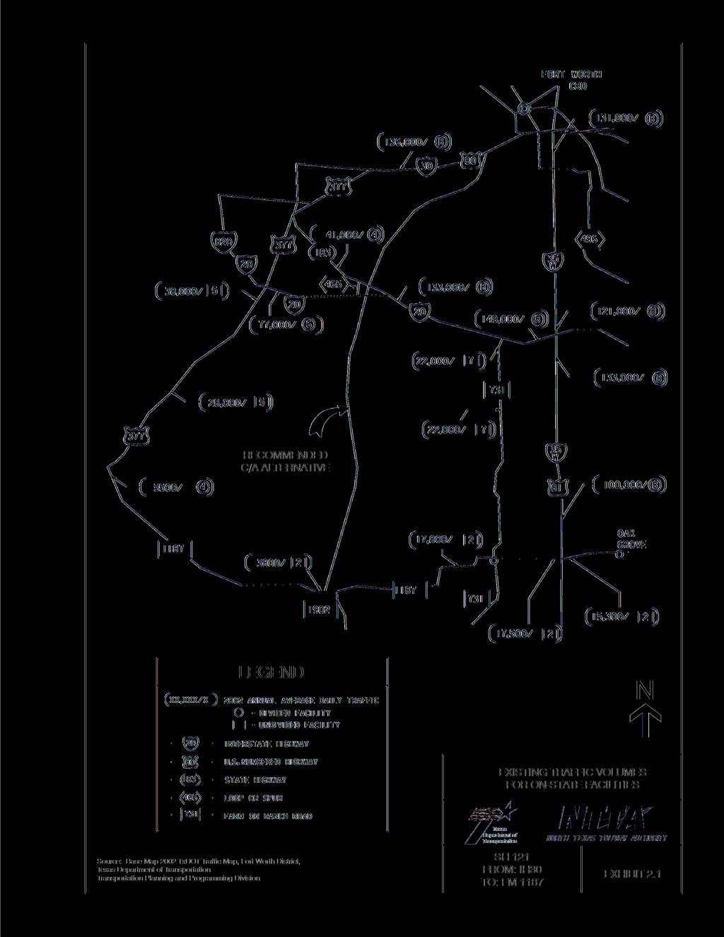
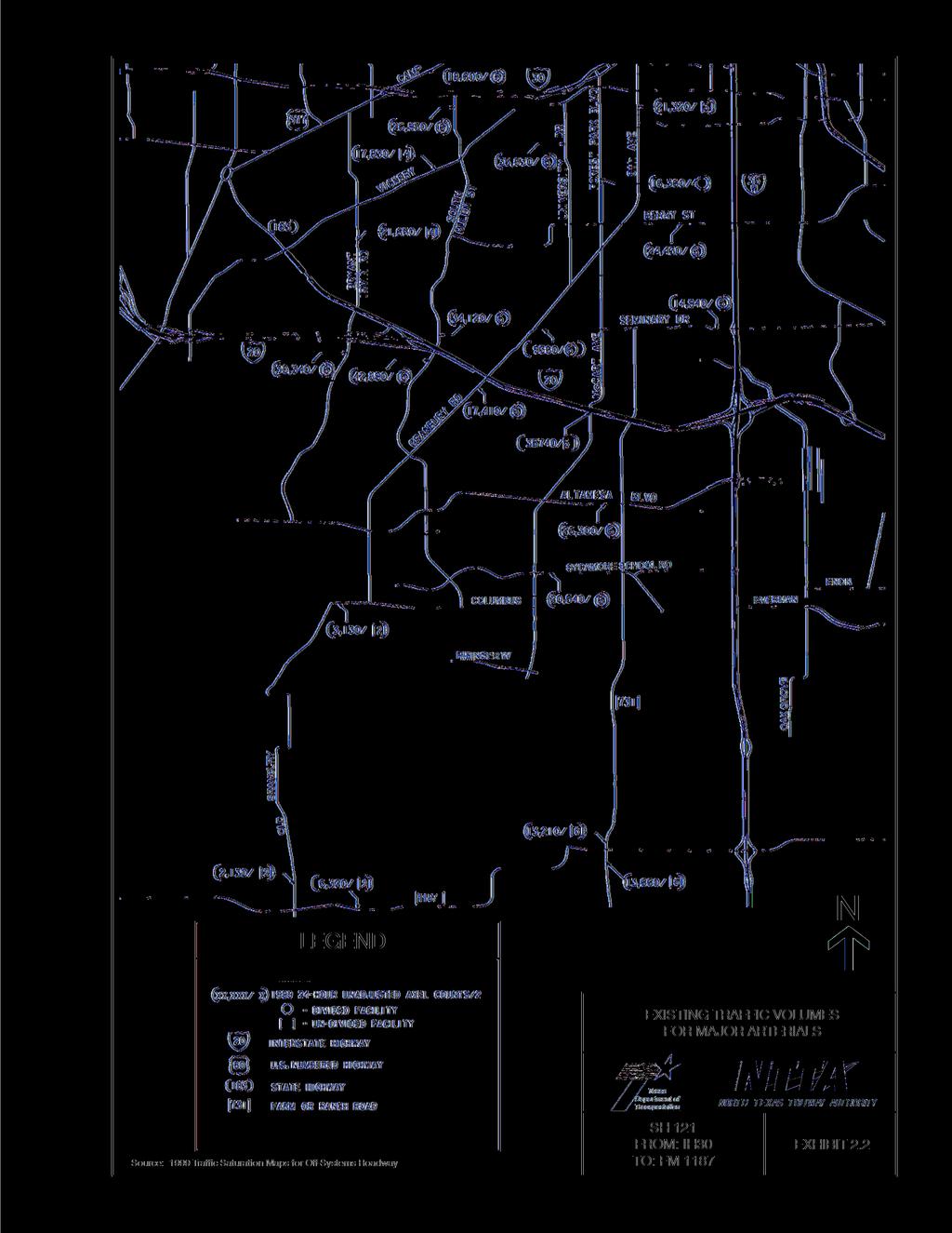
4 facility include the Fort Worth CBD, the West Fort Worth Hospital District and the Southwest Fort Worth market area. In 2004, Lockheed Martin Corporation in Fort Worth led all major employers in the 16-county region with 16,800 workers Growth and Traffic Demand Rapid growth in the DFW area is surpassing the area s transportation system s ability to accommodate traffic demand. Congestion is no longer limited to the traditional peak hour periods or to the CBD. Factors such as population growth, employment growth, automobile ownership, singleoccupant vehicle travel and increased development, have all contributed to the increase in vehicle miles traveled (VMT) across the region. According to NCTCOG s 2025 Mobility Update report, in 1999, transportation demand for the region was 125-million VMT. In the year 2025, this figure is expected to increase to over 200 million VMT. Major arterials that provide north-south access near the PSC (Exhibit 5.2 through Exhibit 5.5) are Bryant Irvin Road and South Hulen Street. Other arterials that provide northeast-southwest access include Vickery Boulevard, Granbury Road and Camp Bowie Boulevard. Motorists who wish to travel between the Fort Worth CBD and southwest Fort Worth currently use the existing freeway system, in combination with the various other major arterials. These movements are made difficult due to congestion on the freeways and because of frequent traffic lights and slower speed limits along local arterials. Observed traffic patterns on these facilities indicate heavy commuter use, with the average weekday traffic substantially higher than average weekend traffic. Existing traffic volumes were obtained for the various freeway and arterial facilities serving the project study area. Traffic data for arterials and for freeways are presented in Exhibit 2.1 and Exhibit 2.2. The level of service (LOS) is a letter designation that describes a range of operating conditions, from free flow operation at LOS A to forced, or breakdown conditions at LOS F. The LOS at which various facilities were operating can be determined by referring to Table 2-1 that shows the recommended maximum average daily traffic (ADT) volumes for various facility types at different 2-3
5 2-4
6 2-5
7 flow conditions. An examination of Table 2-1 and Exhibit 2.2 indicates Bryant Irvin Road (30,430), Hulen Street (42,890), University Drive (36,630) and McCart Avenue (35,740) are operating at worse than tolerable levels of service. Table 2-1 Recommended Maximum Average Daily Traffic* and Level of Service Roadway Class Good Flow Tolerable Flow Capacity Flow LOS A-B LOS C-D LOS E Urban Freeways 4-lane 44,000 52,800 64,400 6-lane 66,000 79,200 96,600 8-lane 88, , ,800 Urban Divided Streets 4-lane 16,100 19,100 23,000 6-lane 23,500 27,900 33,000 8-lane 29,400 34,900 42,000 Urban Undivided Streets 2-lane 7,700 9,100 11,000 4-lane 12,600 14,900 18,000 6-lane 19,800 23,500 28,300 Rural Freeways 4-lane 20,800 31,600 42,000 6-lane 31,200 47,400 63,000 Rural Divided Highways 4-lane 15,800 20,100 29,500 6-lane 23,400 29,800 43,400 Rural Undivided Highways Rolling Terrain 2-lane 2,200 3,800 10,000 Rural Undivided Highways Level Terrain 2-lane 3,200 5,300 13,500 4-lane 9,500 13,000 17,600 6-lane 15,000 19,500 27,100 Source: TxDOT Design Division, Austin, TX. * The volumes assume a percentage of trucks and do not require adjustment to passenger car equivalents. The table is not meant for design purposes but rather for planning evaluations to indicate when tolerable flows are no longer accommodated Regional Transportation Plan Background The regional transportation plan is Federally mandated and serves as a guide for Federal, State and local transportation expenditures. Beginning in the early 1970s, Metropolitan Planning Organizations (MPOs) have been responsible for developing and maintaining a MTP. Passage of the ISTEA and its successor, TEA-21, enacted June 9, 1998, greatly advanced the role of MPOs in the 2-6
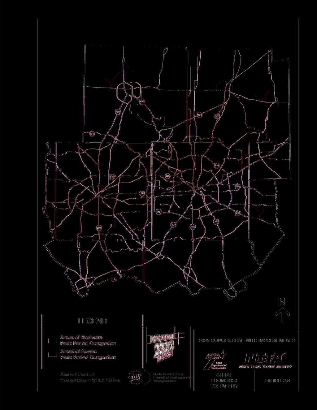
8 overall transportation planning process by placing more emphasis on the need for a centralized mechanism to guide and enhance transportation investments. NCTCOG and the MTP NCTCOG, together with the RTC serves as the MPO for the DFW region. Since the early 1970s, there have been seven transportation plans published by NCTCOG. These are, the Total Transportation Plan for the North Central Texas Region for 1990, completed in 1974; Mobility 2000 The Regional Transportation Plan for North Central Texas, completed in 1986; Mobility The Regional Transportation Plan for North Central Texas completed in 1990; Mobility 2010 Plan Update, completed in 1993; Mobility The MTP, completed and published in September 1997; and Mobility 2025 Plan Update - The MTP, completed and published in January of 2000 and Mobility Update, published in Following in the guidelines of the previous plan, Mobility 2020, the current plan, Mobility Update, was developed following completion of the transit and highway model validation for the base year The plan is based on regional transportation needs identified through the process of forecasting future travel demand, evaluating system alternatives and selecting those options which best meet the mobility needs of the region. A series of travel forecasts were performed including commuter and light rail alternatives, High Occupancy Vehicle (HOV) and express lanes, freeways, tollroads and arterial street improvements. In addition, a system of bicycle and pedestrian facilities was developed. Throughout the planning process, close coordination among local governments, NTTA, TxDOT and transit authorities was maintained. An evaluation of the 2025 baseline forecast was accomplished to identify future congested locations and quantify transportation system needs. In order to assess regional system performance and to further assess project specific system performance following implementation of congestion reduction strategies, a variety of quantifiable performance measures were included in the study. With the Mobility Update recommendations in place (which include proposed SH 121), peak hour congestion levels would occur as illustrated in Exhibit 2.3. Specific legislative requirements also had 2-7
9 2-8
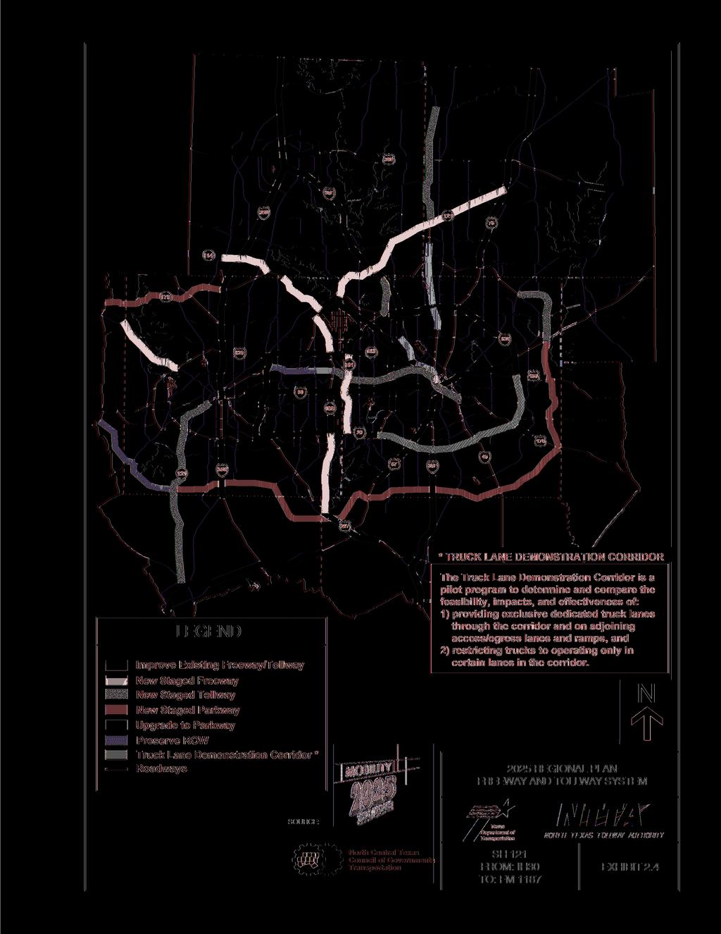
10 to be addressed in the MTP. The CAAA of 1990 established the requirement that all areas designated as non-attainment for exceeding the National Ambient Air Quality Standards (NAAQS) must make conformity determinations on MTPs and TIPs before they are approved. Collin, Dallas, Denton and Tarrant Counties are all designated non-attainment areas for ground level ozone (O 3 ) for 1-hour and 8-hour O3 standard. Under 8-hour standard, ozone concentrations for the average of the annual fourth highest daily eight-hour maximum over a three-year period cannot be at or above 85ppb. A demonstration of transportation conformity for added capacity projects to the 8-hour O3 standard is not required until the end of the EPA one-year grace period. The EPA one-year grace period will end June 15, Mobility Update is required to be in conformity with the SIP for air quality. In accordance with Federal regulations, Mobility Update is constrained to available financial resources. Currently, the proposed action is a part of the NCTCOG s Regional Transportation Plan (Mobility Update) and is included in the TIP for North Central Texas. The proposed action would provide a major link in the future regional transportation network. Mobility Update is the defining vision for transportation systems and services in the DFW Metroplex. In addition to the freeway/tollroad and rail proposals, Mobility Update recommends other improvements in the SH 121 study area, including TSM and travel demand management (TDM) strategies and non-motor vehicle alternatives. In order to aid financing the proposed action, a freeway system evaluation of Mobility Update recommended the construction of SH 121 as a new staged tollroad (Please see Exhibit 2.4). The recommendation was based on a tollroad study, submitted to the Texas Transportation Commission in July 1995, in which alternative financing was sought for the $750 million proposed freeway facility. The findings of this study are discussed in Chapter 3.0, Alternatives Analysis Transportation Demand The CMS is a systematic process for managing traffic congestion. The CMS provides information on transportation system performance, alternative strategies for alleviating congestion and enhancing the mobility of persons and goods to levels that meet State and local needs. Proposed SH 121 is 2-9
11 2-10
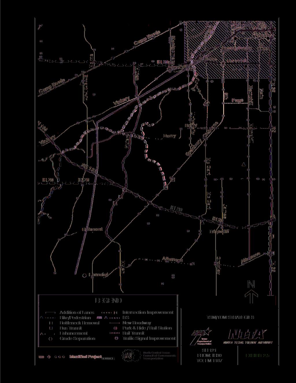
12 included in the NCTCOG s current operational CMS, which meets all requirements of 23 CFR Operational improvements and travel demand reduction strategies are commitments made by the region at two levels: program level and project level implementation. Program level commitments are inventoried in the regional CMS, which was adopted by NCTCOG. They are included in the financially constrained MTP. Future resources are reserved for their implementation. The CMS element of the plan carries an inventory of all project commitments (including those resulting from major investment studies) detailing type of strategy, implementing responsibilities, schedules and expected costs. At the project programming stage, travel demand reduction strategies and commitments would be added to the regional TIP or included in the construction plans. The regional TIP provides for programming of these projects at the appropriate time with respect to the Single Occupancy Vehicle (SOV) facility implementation and project specific elements. Various strategies, including TSM, TDM, capital improvements, land-use strategies and other transportation control measures (TCM) have been evaluated for their effectiveness and feasibility. TSM/TDM strategies in the project vicinity are depicted on Exhibit 2.5. Strategies have been recommended based on ease and cost of implementation, congestion benefits, air quality benefits as well as benefit-cost ratios. The evaluation of projects for inclusion in the TIP are based on current cost-effectiveness, air quality and energy conservation, local cost participation, intermodal/multimodal/social mobility and project inclusion in the Regional CMS or SIP as a Transportation Control Measure. Several regional and specific strategies to reduce congestion have been considered: operational improvements, traffic flow improvements, HOV lanes, improved transit service facilities, light/commuter rail service, bicycle and pedestrian improvements, TDM such as employer trip reduction (ETR) programs, area wide ridesharing (carpooling and van pooling) and voluntary nodrive days. Specific measures are discussed in the following. 2-11
13 2-12
14 Specific Transportation System Management and Transportation Demand Management Strategies Operational improvements: Operational improvements can range from implementation of incident detection and management programs to adding capacity. The CMS for the DFW region recommends that electronic surveillance and response technology (including intelligent transportation systems [ITS] and motorists information systems) be installed and operated on freeways to alleviate congestion. In addition, the CMS recommends that motorists assistance teams (i.e., TxDOT Courtesy Patrol) patrol congested freeway corridors during normal peak hours. The existing ITS is approximately 55 percent complete in Tarrant County. It includes dynamic message signs on roadways to alert drivers of traffic conditions and video cameras to monitor traffic conditions. ITS and motorists assistance programs are designed to detect and quickly respond to incidents and accidents in order to lessen the severity of nonrecurring traffic congestion. TxDOT Courtesy Patrol is presently being used to manage incidents on major freeway sections within Tarrant County. Duties of the Courtesy Patrol include aiding stranded motorists (flat tires, fuel and mechanical problems) and providing traffic control for police and fire departments during responses to roadway accidents. Additionally, these measures can also be used to manage the transportation system and help it operate more efficiently. Traffic flow improvements: The objectives of traffic flow improvements are to maximize the carrying capacity of the roadways, reduce the number of vehicles in queues, increase overall speed, increase roadway capacity and reduce stops and delays. These improvements, also known as TSM improvements, are relatively low cost and easily implemented. Included are items such as: traffic signal retiming/synchronization; restriping to gain additional lanes; adding turning bays; restricting turning movements; and removing bottlenecks. Mobility Update lists specific types of TSMs for the region, which include: retiming/synchronization of traffic signal locations (including across local jurisdictional boundaries); locations for intersection improvements; and freeway bottleneck removal. 2-13
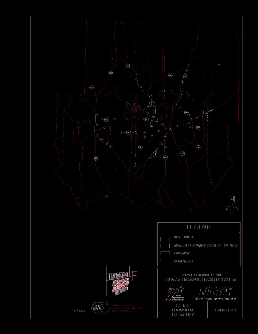
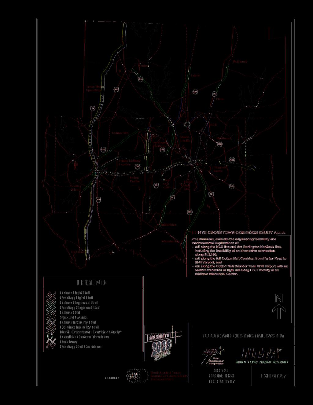
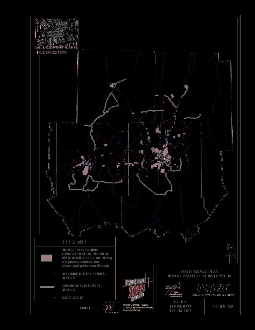
15 HOV lanes: Mobility Update recommends the use of HOV lanes based on current and projected traffic congestion. Candidate HOV corridors were analyzed by forecasting peak hour direction HOV usage for carpools/vanpools and express bus ridership using the DFW Regional Travel Model. Upon completion of the HOV forecast, the peak hour direction warrant of 2,200 persons was applied to each candidate HOV facility and was then checked for peak hour congestion. HOV lanes for the region are identified on Exhibit 2.6. Rail Systems: Mobility Update recommends the use of rail systems such as the Dallas Area Rapid Transit (DART) light rail system and the Trinity Railway Express (TRE). TRE operates between the Fort Worth and Dallas CBDs. The majority of this commuter line uses the former Chicago Rock Island & Pacific Railroad. Primarily, the line serves east-west commuters with stations at various locations in the cities of Dallas, Irving, Arlington, Richland Hills and Fort Worth. Future and existing rail lines under study by NCTCOG are depicted on Exhibit 2.7. Bicycle and pedestrian improvements: On a regional level, Mobility Update explores the opportunities for integrating bicycle and pedestrian traffic into the overall intermodal network in North Central Texas (Please see Exhibit 2.8). Bicycling and walking can also be considered as an effective mode of transportation for home to school, entertainment, shopping, movement between and within residential neighborhoods and recreation. Mobility Update suggests coordinating on-road bikeways with programmed roadway improvements or new construction and developing a regional veloweb, a companion off-system bicycle system. On-road bicycle provisions do not necessarily imply a separate lane would be dedicated for bicycle traffic. A 14-foot wide outside lane, 12-foot wide lane with a two-foot curb offset is beneficial to both bicyclists and motor vehicles. TDM: TDM describes a wide range of actions aimed at improving mobility by lessening the travel demand on the transportation system during peak periods. TDM is also a tool to reduce air pollution and help solve transportation-related problems at individual work sites. TDM strategies encourage 2-14
16 2-15
17 2-16
18 2-17
19 travelers to use other alternatives to driving alone, especially at the most congested times of the day. Examples include congestion-pricing schemes, incentives to increase use of alternative modes of travel and ETR (employee trip reduction) programs. The following describes the TDM strategies being promoted in the DFW area. ETR programs: An ETR program is a concept based on either voluntary or mandatory ETR ordinances to reduce employee commute vehicle trips. Such plans are primarily aimed at public and private employers with at least 100 employees at a single location and are predicted to increase vehicle ridership by 25 percent among participating employees. ETR programs can include numerous elements such as: variable work hours, telecommuting, carpooling/vanpooling incentives, parking management strategies, pedestrian/bicycle incentives and subsidized transit passes, etc. Telecommuting: Telecommuting is working at a location other than the conventional office. The place may be a home or an office close to home. Telecommuting does not necessarily require a computer nor does it have to be a full-time arrangement. One potential effect associated with telecommunicating is the opportunity for increased non-work related trips. Parking Management: Parking management techniques such as priority carpool/vanpool parking and parking pricing/allowance can be incorporated into an ETR program. Parking management, parkand-ride lots and fringe parking were also considered as options to reduce congestion. Parking management is a set of strategies used to balance the supply and demand for parking while addressing related issues such as traffic congestion, air pollution and commuter mobility. These strategies are applicable within the CBD where there is a high density of employment and parking fees. At this time, there are no ordinances requiring employers to charge for parking, provide bicycle parking or limit parking in the DFW region, nor has any local government passed an ordinance stipulating the rates to be charged for parking. 2-18
20 Park-and-Ride Lots: At least two park-and-ride lots have been constructed in the region since 1990 with additional opportunities being investigated. Mobility Update anticipates the construction of additional park-and-ride lots by the year Area-wide Ridesharing: Area-wide ridesharing is considered as a potential traffic congestion reduction measure. The DFW CMS cites ridesharing programs as key elements of the regions TDM efforts. Carpooling and vanpooling are likely to be of primary interest to people who live a long way from work - round trips averaging 25 mi or more for carpools and 30 mi or more for vanpools. For shorter trips, the added time to pick up and drop off passengers and the inconvenience of conforming to a fixed travel schedule would probably outweigh any cost savings or incentives. Home-based work trip information showed round trip work distances of 25 mi or more accounted for 40 percent of the trips in the study area while 33 percent were 30 mi or greater. The availability and cost of parking can be another consideration in the decision to carpool/vanpool. Vanpool Services Incorporated (VPSI) is a regional vanpool facilitator through the Fort Worth Transit Authority (FWTA). Currently, their service provides 15-person passenger vans for vanpools in the study area. FWTA offers rideshare-matching services to create compatible rideshare arrangements. Also, through the Congestion Mitigation and Air Quality Improvement Program(CMAQ), FWTA offers incentives to start and maintain vanpools Congestion Management Systems Summary NTTA, TxDOT and the NCTCOG would continue to promote appropriate congestion reduction strategies through the CMAQ program, the CMS and the MTP. According to NCTCOG, the congestion reduction strategies considered for the area would help alleviate congestion within the region but would not eliminate it Safety/Roadway Deficiencies Similar to most large cities, the existing roadway system in Fort Worth was originally laid out for a historical time period in a more centralized city. Although major reconstruction of the freeway 2-19
21 system is occurring, many of the thoroughfares and local streets forced to serve as thoroughfares, are inadequate in width (capacity), sight distances, safety design features and continuity. There is no direct route of a southwest-to-central orientation similar to what would be provided by the proposed facility. Additionally, the user demands for many of these urban roadways cause them to carry more traffic than they were designed for, thus leading to congested conditions. This congestion leads to higher costs to the traveling public. Without major improvements, including disruptive reconstruction of the existing roadway network, the existing system would continue to become more congested. The increased congestion would lead to hazardous and unsafe conditions that would likely result in higher accident rates. The proposed facility, by providing a direct and continuous southwest-to-central major traffic arterial, would improve access and travel time of public safety vehicles and emergency services. The proposed facility would also provide a controlled access highway that would complement the existing City of Fort Worth s Master Thoroughfare Plan Funding and Legislation Section 1602 of the Transportation Equity Act (TEA) for the 21st Century (TEA-21, P.L , June 9, 1998), known as the High Priority Projects Program provides designated funding for specific projects (commonly referred to as demonstration projects) identified by Congress and is now included in 23 USC.117. TEA-21 includes 1,850 of these projects, each with a specified amount of funding over the six years of TEA-21. The designated funding can only be used for the projects as described in the law [1601(a)]. With support from U.S. House of Representatives member Kay Granger of the 12th District (R-Texas), funding in the amount of $25 million has been earmarked specifically for the construction of SH 121 from IH 30 to the Tarrant/Johnson County Line (plus an additional $7 million to extend to US 67 in Cleburne), under this category of TEA
22 The SH 121 study was authorized by MOs No and and approved by the Texas Transportation Commission on August 29, 1985 and January 30, 1986, respectively. MO No was accepted by the City on October 15, 1985, by a Fort Worth City Council and Mayor communication (Number G-6454). The Commissioners Court of Tarrant County adopted MO No by resolution on November 25, Environmental review and approval of the proposed facility is governed by the National Environmental Policy Act (NEPA) and its implementing regulations; regulations and procedural guidelines of the FHWA (23 CFR 771 and 772) TxDOT guidelines and 43 Texas Administrative Code (TAC) Chapter 2, Subchapter C. 2-21
23 This page is intentionally left blank. 2-22
Congestion Management Process 2013 Update
 OVERVIEW OF THE DALLAS-FORT WORTH CONGESTION MANAGEMENT PROCESS Traffic Congestion In The Dallas-Fort Worth Region With the Dallas-Fort Worth (DFW) urban area as its center, the North Central Texas region
SECTION III - REGIONAL ARTERIAL SYSTEM. The Regional Arterial System is a subcomponent of a broader regional thoroughfare system.
 SECTION III - REGIONAL ARTERIAL SYSTEM SYSTEM IDENTIFICATION The Regional Arterial System is a subcomponent of a broader regional thoroughfare system. The NCTCOG Regional Thoroughfare Plan (RTP) recognizes
North Central Texas Council of Governments 157
 13. Transportation System Safety The goal of the Transportation System Safety Program Area is to improve transportation safety throughout the region by supporting planning efforts to develop safety policies,
IMPLICATIONS OF BEING DESIGNATED NONATTAINMENT
 IMPLICATIONS OF BEING DESIGNATED NONATTAINMENT WTS San Antonio/SWITE Professional Development Seminar Jenny Narvaez, Principal Air Quality Planner North Central Texas Council of Governments August 4, 2017
MONITORING IMPLEMENTATION AND PERFORMANCE
 12 MONITORING IMPLEMENTATION AND PERFORMANCE The FAST Act continues the legislation authorized under MAP-21, which created a data-driven, performance-based multimodal program to address the many challenges
Congestion Management Process Update
 report Congestion Management Process Update prepared for Houston-Galveston Area Council prepared by Cambridge Systematics, Inc. 10415 Morado Circle, Building II, Suite 340 Austin, TX 78759 with Alliance
PUBLICATIONS MAPS DATA
 PUBLICATIONS MAPS DATA REGIONAL INFORMATION CENTER North Central Texas Council of Governments Centerpoint Two, 616 Six Flags Drive, 76011 P. O. Box 5888, Arlington, Texas 76005-5888 Telephone: (817) 640-3300
AIR QUALITY AND CLIMATE CHANGE EVALUATION GUIDANCE
 AIR QUALITY AND CLIMATE CHANGE EVALUATION GUIDANCE The following guidance provides additional details regarding the process followed by PSRC to evaluate projects for potential air quality benefits. As
This page intentionally left blank.
 EXECUTIVE SUMMARY This page intentionally left blank. SATOMORROW MULTIMODAL TRANSPORTATION PLAN EXECUTIVE SUMMARY Introduction The City of San Antonio is anticipated to experience tremendous growth resulting
GUIDING PRINCIPLES MEMORANDUM
 M E T R O P O L I TAN TRA NS P O RTATI O N PLAN GUIDING PRINCIPLES MEMORANDUM El Paso Metropolitan Planning Organization INTRODUCTION The guiding principles for development of the El Paso MPO s Destino
Houston Galveston Area Council Congestion Management Process
 Houston Galveston Area Council Congestion Management Process APPENDIX G of the 2035 Regional Transportation Plan Update Prepared for: Houston-Galveston Area Council Transportation Department 3555 Timmons
The Policies section will also provide guidance and short range policies in order to accomplish the goals and objectives.
 4 Goals & Objectives INTRODUCTION The 2015-2040 MTP preserves and promotes the quality of life and economic prosperity of the MAB by providing a transportation system consistent with the regional goals.
DRAFT Congestion Management Process Keeping the Region Moving Efficiently, Reliably, and Safely
 Congestion Management Process Keeping the Region Moving Efficiently, Reliably, and Safely February 28, 2017 Prepared by the Tri-County Regional Planning Commission 3135 Pine Tree, Suite 2C Lansing, Michigan
Chapter 3 - Goals, Objectives, & Strategies
 Chapter 3 - This chapter presents goals, objectives, and strategies that have been developed as part of the Richmond Area MPO 2026 Long-Range Transportation Plan (LRTP) update. Strategies have been developed
Congestion Management Process Keeping the Region Moving Efficiently, Reliably, and Safely
 Congestion Management Process Keeping the Region Moving Efficiently, Reliably, and Safely Reviewed and Adopted By Tri-County Regional Planning Commission May 24, 2017 Prepared by the Tri-County Regional
Regional Initiatives on Land Use and Transportation
 Regional Initiatives on Land Use and Transportation Alicia Hopkins, AICP, Senior Transportation Planner North Central Texas Council of Governments SEE Development Excellence Day November 2005 North Central
NORTH CENTRAL TEXAS COUNCIL OF GOVERNMENTS. OU Meteorology Field Trip October 20, 2017
 NORTH CENTRAL TEXAS COUNCIL OF GOVERNMENTS OU Meteorology Field Trip October 20, 2017 THE BASICS: WHO WE ARE North Central Texas Council of Governments (NCTCOG) is: 1 of 24 COGs Across Texas 364 Employees;
2030 Transportation Policy Plan SUMMARY PRESENTATION. Land Use Advisory Committee November 15, 2012
 2030 Transportation Policy Plan SUMMARY PRESENTATION Land Use Advisory Committee November 15, 2012 Today s Topics Transportation Policy Plan (TPP) Requirements and Background Current TPP Policies, Issues
3. STATION SPACING AND SITING GUIDELINES
 3. STATION SPACING AND SITING GUIDELINES The station spacing and siting guidelines are summarized in Table 3-1. Table 3-1 also includes benchmark information for local transit service and express bus as
PINELLAS COUNTY MOBILITY PLAN SUMMARY REPORT
 PINELLAS COUNTY MOBILITY PLAN SUMMARY REPORT In September, 2013, the Pinellas County Mobility Plan Report was approved by the Metropolitan Planning Organization (MPO). This action endorsed a countywide
IH 820 Corridor Improvement Study Randol Mill Road To North SH 121 Interchange. Public Meeting. Thursday April 4, 2013
 IH 820 Corridor Improvement Study Randol Mill Road To North SH 121 Interchange Public Meeting Thursday April 4, 2013 1 Project Contacts: TxDOT-Fort Worth District John R. Tillinghast, P.E. IH 820 Project
ATTACHMENT A. Detailed Study Scope. I-66 (Inside) Multi-modal Study Scope
 Multi-modal Study Scope") ATTACHMENT A Detailed Study Scope I-66 (Inside) Multi-modal Study Scope EXECUTIVE SUMMARY The Virginia Department of Transportation (VDOT) seeks consultant assistance in identifying and evaluating a range
ATTACHMENT A Detailed Study Scope I-66 (Inside) Multi-modal Study Scope EXECUTIVE SUMMARY The Virginia Department of Transportation (VDOT) seeks consultant assistance in identifying and evaluating a range
From Policy to Reality
 From Policy to Reality Updated ^ Model Ordinances for Sustainable Development 2000 Environmental Quality Board 2008 Minnesota Pollution Control Agency Funded by a Minnesota Pollution Control Agency Sustainable
Blacklands Corridor Feasibility Study
 Blacklands Corridor Feasibility Study Public Meeting May 13, 2014 The Atrium at the Granville Arts Center 300 N. Fifth Street, Garland, Texas 1 Overview Welcome and Public Involvement Efforts Amanda Wilson
KAW CONNECTS EXECUTIVE SUMMARY
 Executive Summary Page E-1 Introduction KAW CONNECTS EXECUTIVE SUMMARY The Kansas Department of Transportation (KDOT) and the Kansas Turnpike Authority (KTA) have both recognized the need to plan for the
1RUWKZHVW#:LFKLWD 0DMRU#,QYHVWPHQW#6WXG\
 1RUWKZHVW#:LFKLWD 0DMRU#,QYHVWPHQW#6WXG\ Executive Summary 3UHSDUHGýIRUã 3UHSDUHGýE\ã.DQVDVý'HSDUWPHQWýRI 7UDQVSRUWDWLRQ,QýDVVRFLDWLRQýZLWKã (DUWKý7HFKý,QFï EXECUTIVE SUMMARY Introduction This Northwest
Travel Demand Modeling At NCTCOG
 Travel Demand Modeling At NCTCOG Arash Mirzaei North Central Texas Council Of Governments For University of Texas at Arlington ITE Student Chapter March 9, 2005 Agenda Background DFW Regional Model Structure
1.1 Purpose of the Project
 Chapter 1 Purpose and Need for East Link Project 1.1 Purpose of the Project The purpose of the East Link Project is to expand the Sound Transit Link light rail system from Seattle to Mercer Island, Bellevue
DENVER REGIONAL COUNCIL OF GOVERNMENTS 1290 BROADWAY, SUITE 100 DENVER, CO
 DENVER REGIONAL COUNCIL OF GOVERNMENTS 1290 BROADWAY, SUITE 100 DENVER, CO 80203 WWW.DRCOG.ORG Preparation of this report has been financed in part through grants from the U.S. Department of Transportation,
Los Angeles County Congestion Reduction Demonstration Project
 Los Angeles County Congestion Reduction Demonstration Project frequently asked questions update #1 /august 2008 Los Angeles County Metropolitan Transportation Authority (Metro), California Department of
CRTPA Regional Mobility Plan Attachment 1 Agenda Item 4E Page 1 of 11
 CRTPA Regional Mobility Plan Attachment 1 Page 1 of 11 INTRODUCTION Everyone wants to have the ability to move around the city, county, region, country and world in the way that they see fit, when they
The transportation needs described demonstrate that improvements are needed to meet the anticipated demands of travelers in the corridor and region.
 traveling to jobs in the corridor and in downtown Dallas, and residents from elsewhere in the region traveling to jobs in the corridor (reverse commute). Improve Accessibility and Increase Economic Development
6.1 INTRODUCTION 6.2 REGULATORY FRAMEWORK NATIONAL AMBIENT AIR QUALITY STANDARDS COMPLIANCE STATUS TRANSPORTATION CONFORMITY
 Chapter 6 Air Quality 6.1 INTRODUCTION This chapter presents a project-level analysis of the potential for air quality impacts that could result from mobile and stationary sources of air emissions generated
Intelligent Transportation Systems Master Plan
 Space Coast Transportation Planning Organization Intelligent Transportation Systems Master Plan April 15, 2014 Version 1.0 Prepared for: Space Coast Transportation Planning Organization 2725 Judge Fran
TCATS October 12-Michigan Works 5:30-7pm. NATS October 19-Niles District Library 6-7:30pm
 Goal Development Workshop TCATS October 12- Works 5:30-7pm NATS October 19-Niles District Library 6-7:30pm SAFETEA-LU Goals 2035 TwinCATS Goals 2030 TwinCATS Goals 1. Support the economic vitality of the
APPENDIX H: TRAVEL DEMAND MODEL VALIDATION AND ANALYSIS
 APPENDIX H: TRAVEL DEMAND MODEL VALIDATION AND ANALYSIS Travel demand models (TDM) simulate current travel conditions and forecast future travel patterns and conditions based on planned system improvements
Rapid City Area Metropolitan Planning Organization OPERATIONS PLAN
 Rapid City Area Metropolitan Planning Organization OPERATIONS PLAN Prepared for the Rapid City Area Metropolitan Planning Organization Endorsed by the Executive Policy Committee of the Rapid City Area
DART s Role in Transit - Oriented Development. Jack Wierzenski,, Director Economic Development & Planning Dallas Area Rapid Transit
 DART s Role in Transit - Oriented Development Jack Wierzenski,, Director Economic Development & Planning Dallas Area Rapid Transit The DART System Established in 1983 13 Member Cities Local Funding: $.01
- FACT SHEET - THE GUIDING PRINCIPLES
 THE GUIDING PRINCIPLES The General Plan begins with seven ideas that together create a vision for the City s future. When the City approved the General Plan in 1994, these idea were dubbed the Seven Guiding
Transform 66 Multimodal Project: Prioritization Process and Evaluation Criteria Approved March 3, 2016
 Transform 66 Multimodal Project: Prioritization Process and Evaluation Criteria Approved March 3, 2016 The Memorandum of Agreement (MOA) for the Transform 66: Inside the Beltway Project directs NVTC to
IH 35W/IH 820 Partial Interchange Fort Worth, TX TIGER Project Application. TIGER DISCRETIONARY PROGRAM Project Application
 TIGER DISCRETIONARY PROGRAM Project Application Name of Project: IH 35 W/IH 820 Partial Interchange Configuration Agency Submitting Project: North Central Texas Council of Governments Primary Contact:
Interstate 70 Corridor Study
 Clark County, Ohio Interstate 70 Corridor Study prepared by Clark County-Springfield Transportation Coordinating Committee with Ohio Department of Transportation Office of Urban and Corridor Planning and
NORTH I-75 MASTER PLAN Summary Report
 NORTH I-75 MASTER PLAN Summary Report Interstate 75 (SR 93) From the Florida s Turnpike Interchange to the I-10 Interchange Alachua, Bradford, Clay, Citrus, Columbia, Duval, Levy, Marion, and Sumter Counties,
Chapter 4: Transportation and Land Use
 Chapter 4: Transportation and Land Use Transportation and land use together make possible the wide range of destination opportunities in the region. Transportation provides the connections, and, in turn,
North Central Texas Council of Governments. Air Quality. Handbook Spring 2018
 Air Quality Handbook Spring 2018 This Air Quality Handbook presents the current status of regional air quality and a summary of the work undertaken by the North Central Texas as the metropolitan planning
VEHICLES MILES TRAVELED (VMT) TRAFFIC IMPACT METRIC
 TRAFFIC IMPACT METRIC") VEHICLES MILES TRAVELED (VMT) TRAFFIC IMPACT METRIC A project-specific quantified analysis of the MGA Campus has been undertaken to compare BAU to the project including the project s VMT reduction program
VEHICLES MILES TRAVELED (VMT) TRAFFIC IMPACT METRIC A project-specific quantified analysis of the MGA Campus has been undertaken to compare BAU to the project including the project s VMT reduction program
ENVIRONMENTAL ASSESSMENT INTERSTATE HIGHWAY 35W FROM INTERSTATE HIGHWAY 820 TO INTERSTATE HIGHWAY 30 CITY OF FORT WORTH TARRANT COUNTY, TEXAS
 ENVIRONMENTAL ASSESSMENT INTERSTATE HIGHWAY 35W FROM INTERSTATE HIGHWAY 820 TO INTERSTATE HIGHWAY 30 CITY OF FORT WORTH TARRANT COUNTY, TEXAS CSJ Nos. 0014-16-179 0014-16-268 PREPARED BY: UNITED STATES
TRANSPORTATION TRANSPORTATION 9-1
 TRANSPORTATION Community Vision 2028 Because we place such high value on our natural surroundings, we responsibly plan for, manage, and mitigate the impacts of growth on those surroundings. Kezziah Watkins
I-70 East ROD 1: Phase 1 (Central 70 Project) Air Quality Conformity Technical Report
 Air Quality Conformity Technical Report") I-70 East ROD 1: Air Quality Conformity Technical Report January 2017 I-70 East ROD 1: Air Quality Conformity Technical Report TABLE OF CONTENTS Chapter Page 1 PURPOSE OF THIS REPORT... 1 2 PROJECT DESCRIPTION...
I-70 East ROD 1: Air Quality Conformity Technical Report January 2017 I-70 East ROD 1: Air Quality Conformity Technical Report TABLE OF CONTENTS Chapter Page 1 PURPOSE OF THIS REPORT... 1 2 PROJECT DESCRIPTION...
Subarea Mobility Enhancements. 5.1 Transit and Pedestrian Improvements
 Section Five Section 5: Subarea Mobility Enhancements 5.1 Transit and Pedestrian Improvements From the outset of the master planning process, one of the primary goals was to integrate transit and pedestrian-oriented
Appendix D: Functional Classification Criteria and Characteristics, and MnDOT Access Guidance
 APPENDICES Appendix D: Functional Classification Criteria and Characteristics, and MnDOT Access Guidance D.1 Functional classification identifies the role a highway or street plays in the transportation
Transportation Concurrency
 2015 Frequently Asked Questions About. Transportation Concurrency Q. What is Transportation Concurrency? A. Transportation Concurrency is both a State law requirement and a City pre-application development
6.2.2 Environmental Consequences and Mitigation Measures
 6.2 6.2.1 Introduction The existing conditions, regulatory setting, and methods of analysis for transportation under CEQA are described in Chapter 3, NEPA and CEQA Analysis. Impacts that would result from
APPENDIX B. Public Works and Development Engineering Services Division Guidelines for Traffic Impact Studies
 APPENDIX B Public Works and Development Engineering Services Division Guidelines for Traffic Impact Studies Revised December 7, 2010 via Resolution # 100991 Reformatted March 18, 2011 TABLE OF CONTENTS
Current Trends in Traffic Congestion Mitigation
 Current Trends in Traffic Congestion Mitigation April 24, 2009 NCSL Spring Forum Washington, DC Jeff Lindley Associate Administrator, Office of Operations Federal Highway Administration U.S. Department
TRAFFIC FORECASTING REQUIREMENTS BY PROJECT TYPE. August Research Report
 I. Report No. 2. Government Accession No. FHWA/TX-95 I 1235-8 4. Tide and Subtitle TRAFFIC FORECASTING REQUIREMENTS BY PROJECT TYPE Technical Report Documentation Page 3. Recipient's Catalog No. 5. Report
Sustainability. Sustainability Principles. 1. Framework. Spokane Transit s definition of Sustainability is:
 Sustainability Spokane Transit s definition of Sustainability is: Sustainability at Spokane Transit is about providing services in ways that optimize our ability to meet the needs of present and future
CHAPTER 1: INTRODUCTION/ GOALS AND OBJECTIVES
 CHAPTER 1: INTRODUCTION/ GOALS AND OBJECTIVES 1.1: INTRODUCTION ABOUT THE FREDERICKSBURG AREA METROPOLITAN PLANNING ORGANIZATION (FAMPO) Established in 1992, the Fredericksburg Area Metropolitan Planning
Performance Measures: Roadway Safety and Transit Asset Management. Regional Transportation Council Information Item November 9, 2017
 Performance Measures: Roadway Safety and Transit Asset Management Regional Transportation Council Information Item November 9, 2017 Federally Required Performance Measures Highway Safety Improvement Program
LMPO 2040 Metropolitan Transportation Plan. Table of Contents
 Table of Contents Chapter 1: Introduction... 3 Changes... 3 Study Area Boundaries... 3 Metropolitan Planning Organization... 3 MAP-21... 3 Plan Preparation... 5 Study Area... 6 Map 1: Study Area Boundary...
Pima County Travel Reduction Ordinance
 Pima County Travel Reduction Ordinance Source: http://www.municode.com/resources/gateway.asp?pid=16119&sid=3 Chapter 17.40 TRAVEL REDUCTION ORDINANCE Sections: Article I. General Provisions 17.40.010 Short
SH 35 Public Meeting
 SH 35 Public Meeting Major Corridor Feasibility Study Environmental Impact Statement March 27 and 28, 2007 Good evening and welcome to the State Highway 35 Public Meeting. This meeting is being conducted
The Cost Savings Potential of Sustainability Practices
 The Cost Savings Potential of Sustainability Practices The Sustainability Triple Bottom Line The Triple Bottom Line (TBL) means addressing Environmental, Economic and Social Equity dimensions of a project
HCM 6th Edition Planning and Preliminary Engineering Applications Guide (PPEAG) to the HCM Bringing Back-of-the-Envelope Back.
 to the HCM Bringing Back-of-the-Envelope Back.") HCM 6th Edition Planning and Preliminary Engineering Applications Guide (PPEAG) to the HCM Bringing Back-of-the-Envelope Back April, 2017 Potential Use of the HCM in Planning The HCM is commonly used to
HCM 6th Edition Planning and Preliminary Engineering Applications Guide (PPEAG) to the HCM Bringing Back-of-the-Envelope Back April, 2017 Potential Use of the HCM in Planning The HCM is commonly used to
September Public Meetings. Developing a Blueprint for the Corridor
 September Public Meetings Developing a Blueprint for the Corridor Study Background Study initiated by the Commonwealth Transportation Board (CTB) and administered by VDOT in association with VDRPT. Addresses
10.2 SYSTEM DEVELOPMENT
 10.0 TRANSPORTATION 10.1 INTRODUCTION The purpose of the Irving Thoroughfare Plan, as a component of the Comprehensive Plan, is to accommodate the existing and future roadway transportation needs of the
CITY OF JACKSONVILLE 2030 MOBILITY PLAN STUDY UPDATE GOALS, OBJECTIVES, AND PERFORMANCE MEASURES PREPARED FOR: CITY OF JACKSONVILLE
 CITY OF JACKSONVILLE 2030 MOBILITY PLAN STUDY UPDATE GOALS, OBJECTIVES, AND PERFORMANCE MEASURES 3.20.2017 PREPARED FOR: CITY OF JACKSONVILLE 55 Railroad Row White River Junction, VT 05001 802.295.4999
Introduction to the Proposed Statewide Transportation Improvement Program (STIP) Transportation Planning and Programming
 Transportation Planning and Programming") Introduction to the Proposed 2015-2018 Statewide Transportation Improvement Program (STIP) Transportation Planning and Programming Public Hearing August 19 th, 2014 TABLE OF CONTENTS Introduction... 1
Introduction to the Proposed 2015-2018 Statewide Transportation Improvement Program (STIP) Transportation Planning and Programming Public Hearing August 19 th, 2014 TABLE OF CONTENTS Introduction... 1
Maximize Transportation System Capacity
 US 75 Integrated Corridor Management System Using Technology and Partnership to Using Technology and Partnership to Maximize Transportation System Capacity What is ICM? The integrated management of freeway,
USING TRAVEL TIME RELIABILITY DATA TO DEVELOP CONGESTION MANAGEMENT STRATEGIES IN THE TRANSPORTATION PLANNING PROCESS.
 USING TRAVEL TIME RELIABILITY DATA TO DEVELOP CONGESTION MANAGEMENT STRATEGIES IN THE TRANSPORTATION PLANNING PROCESS by Shuangshuo Wang B.S. Engineering, Tongji University, 2014 Submitted to the Graduate
TIGER DISCRETIONARY PROGRAM Project Application. Agency Submitting Project: North Central Texas Council of Governments
 TIGER DISCRETIONARY PROGRAM Project Application Name of Project: SH 121 (Section 13) Agency Submitting Project: North Central Texas Council of Governments Primary Contact: Name: Michael Morris Phone Number:
Memorandum. FROM: Jim Ortbal Rosalynn Hughey Barry Ng TO: HONORABLE MAYOR, CITY COUNCIL. DATE: June 16, 2017
 CITY OF SANjOSE CAPITAL OF SILICON VALLEY TO: HONORABLE MAYOR, CITY COUNCIL SUBJECT: TRANSPORTATION POLICY UPDATE REQUIRED BY STATE LAW - LOS TO VMT Memorandum FROM: Jim Ortbal Rosalynn Hughey Barry Ng
I-66 Corridor Improvements Outside the Capital Beltway in Northern Virginia, USA
 15th International Conference on Managed Lanes I-66 Corridor Improvements Outside the Capital Beltway in Northern Virginia, USA Case Study for Funding of Transit Service and Transportation Demand Management
City of Brantford Chapter 3 TABLE OF CONTENTS
 Chapter 3 The Land Use & Transportation Connection TABLE OF CONTENTS 3.1 THE LAND USE & TRANSPORTATION LINK... 1 3.2 POPULATION & EMPLOYMENT GROWTH FORECASTS... 3 3.2.1 Proposed Places to Grow Plan Forecasts
Texas Urban Mobility Plan: Breaking the Gridlock
 Texas Urban Mobility Plan: Breaking the Gridlock Laredo-Webb County Metropolitan Planning Organization Metropolitan Planning Organization Policy Committee Members STATE REPRESENTATIVES: Mr. Mario Medina,
Re: Mobility Plan 2035 FEIR Greenhouse Gas Emissions Analysis
 Sirius Environmental Claire Bowin, Senior City Planner City of Los Angeles, Department of City Planning 200 North Spring Street, Room 272 Los Angeles, California 90012 Dear Claire: Re: Mobility Plan 2035
ENVIRONMENTAL ASSESSMENT INTERSTATE HIGHWAY 35W FROM STATE HIGHWAY 114 TO INTERSTATE HIGHWAY 820
 ENVIRONMENTAL ASSESSMENT INTERSTATE HIGHWAY 35W FROM STATE HIGHWAY 114 TO INTERSTATE HIGHWAY 820 CITIES OF FORT WORTH AND HASLET TARRANT AND DENTON COUNTIES, TEXAS CSJ Nos. 0014-16-252 0014-16-255 0081-12-041
MULTIMODAL NEEDS ASSESSMENT
 6. FREIGHT INTRODUCTION Transportation systems not only move people throughout a region, but they also support the movement of goods in the form of freight, which is a vital component of the region s economy
Greenhouse Gas Emission Reduction Strategies
 Greenhouse Gas Emission Reduction Strategies 2011 ITE Quad Conference April 18 19, 2011, Embassy Suites; Lynnwood, WA Victor L. Sl Salemann, PE Senior Associate David Evans and Associates Bellevue, WA
3.6 GROUND TRANSPORTATION
 3.6.1 Environmental Setting 3.6.1.1 Area of Influence The area of influence for ground transportation consists of the streets and intersections that could be affected by automobile or truck traffic to
Appendix A: Land Transportation Glossary
 Appendix A: Land Transportation Glossary A Accessible Access to opportunities Americans with Disabilities Act (ADA) Alternatives Analysis (AA) Arterial routes Automatic vehicle location (AVL) Auto occupancy
Alternatives Analysis, New Starts
 Alternatives Analysis, New Starts E. Beimborn, University of Wisconsin-Milwaukee 1 Outline Overview The process at the local level FTA new starts process Project justification Financial rating Forecasting
3.0 REVIEW OF PREVIOUS STUDIES
 3.0 REVIEW OF PREVIOUS STUDIES This section of the highlights the significant features from previous plans and studies that could impact the development of the I-20 East Transit Initiative. Much of the
1.0 INTRODUCTION. Athens Transit System Transit Development Plan 1.0 Introduction. 1.1 System Overview
 1.0 INTRODUCTION 1.1 System Overview Athens Transit System (ATS) is the public transportation provider for Athens-Clarke County Georgia. ATS bus transit services consist of 18 fixed routes (referred to
TRAFFIC STUDY GUIDELINES
 TRAFFIC STUDY GUIDELINES December 2013 The scope of the traffic impact analysis (TIA) should follow these guidelines and the requirements of VMC 11.80.130 and VMC 11.70, transportation concurrency (attached
Integrated Corridor Management --An Overview --
 Integrated Corridor Management --An Overview -- Neil Spiller FHWA Office of Operations Program Manager: ICM KBPS video 1 Integrated.. combining or coordinating separate agencies so as to provide a harmonious,
A Win/Win Strategy: Fixing Transportation and Reducing Greenhouse Gas Emissions in Massachusetts
 Northeastern University Dukakis Center for Urban & Regional Policy A Win/Win Strategy: Fixing Transportation and Reducing Greenhouse Gas Emissions in Massachusetts E2/T4MA/NRDC EcoSalon Full Speed Ahead:
Transit Service Guidelines
 G R E AT E R VA N CO U V E R T R A N S P O RTAT I O N A U T H O R I T Y Transit Service Guidelines PUBLIC SUMMARY REPORT JUNE 2004 Greater Vancouver Transportation Authority TRANSIT SERVICE GUIDELINES
THE REGION S PLAN POLICY FRAMEWORK. August 2015
 THE REGION S PLAN POLICY FRAMEWORK August 2015 2 What is The Policy Framework? Cover photo credit: Sinan Sinharoy for Atlanta BeltLine, Inc. Atlanta is one of the world s most dynamic metropolitan areas,
Dallas Integrated Corridor Management (ICM) Update
 Update") Dallas Integrated Corridor Management (ICM) Update North Central Texas Council of Governments Surface Transportation Technical Committee April 26, 2013 What is ICM? The integrated management of freeway,
Dallas Integrated Corridor Management (ICM) Update North Central Texas Council of Governments Surface Transportation Technical Committee April 26, 2013 What is ICM? The integrated management of freeway,
1.1.1.b. Agencies share best practices as they integrate COMPASS facilitates
 Transportation Goals 1.1 Enhance the system to improve accessibility and connectivity to jobs, schools, and services; allow the efficient movement of people and goods; and ensure the reliability of travel
Chapter 4: Developing the Recommendations
 Virginia s continued investment in its transportation system is vital to the safe and efficient movement of people and goods and to the entire Commonwealth s economic wellbeing. Every element of Virginia
METRA UP-W LINE. Locally Preferred Alternative Report
 METRA UP-W LINE Cook, Kane, and DuPage Counties Illinois Alternatives Analysis Study Document #9 Locally Preferred Alternative Report August 13, 2007 Prepared by Parsons Alternatives Analysis Documents
Incorporating TMS into Planning. Jianming Ma, Ph.D., P.E.
 Incorporating TMS into Planning Jianming Ma, Ph.D., P.E. Table of Contents 1 What is TMS 3-4 2 Transportation Environment is Changing 5-6 3 Benefits from TMS 7-8 4 Traditional Approach to Managing Transportation
US 75 Integrated Corridor Management System Using Technology and Partnership to Maximize Transportation System Capacity
 US 75 Integrated Corridor Management System Using Technology and Partnership to Maximize Transportation System Capacity Ahmad Sadegh, Ph.D. Schneider Electric US 75 Corridor Networks Freeway with continuous
FLORIDA DEPARTMENT OF TRANSPORTATION Planning and Environmental Management Office INTERCHANGE MODIFICATION REPORT
 FLORIDA DEPARTMENT OF TRANSPORTATION Planning and Environmental Management Office INTERCHANGE MODIFICATION REPORT District 2 1109 South Marion Avenue Lake City, FL 32025-5874 INTERSTATE 10 (SR 8) / SR
Mobility and System Reliability Goal
 Mobility and System Reliability Goal Provide surface transportation infrastructure and services that will advance the efficient and reliable movement of people and goods throughout the state. Background:
I-710 Project Committee Meeting
 Los Angeles County Metropolitan Transportation Authority I-710 Project Committee Meeting January 29, 2009 Meeting Expectations Review I-710 planning context Concur on a port cargo forecast scenario to
Downtown Estes Loop Project Frequently Asked Questions
 May 15 th, 2015 Project Status 1) Has Alternative 1 already been selected? Is it a done deal? Response: The NEPA process will proceed with environmental analysis of both the No Action and Alternative 1.
OZONE IN NORTH TEXAS AND THE CLEAN AIR ACT
 OZONE IN NORTH TEXAS AND THE CLEAN AIR ACT North Texas Commission Topics: North Texas Webinar Series June 25, 2014 Chris Klaus, Senior Program Manager Mindy Mize, Program Manager Air Quality Planning &