Analysis of Major Transport Corridors. 4.1 Introduction and Methodology of Evaluation
|
|
|
- Teresa Ross
- 5 years ago
- Views:
Transcription
1 CHAPTER 4 Analysis of Major Transport Corridors 4.1 Introduction and Methodology of Evaluation In this section, the infrastructure development options, including the improvement of public transport services, were evaluated for each corridor based on the circumstances of land use, urban development, transport conditions and future estimation with tested options. The corridors are identified as the seven major corridors connecting the central area of Colombo and the suburbs, such as Malabe, Galle, Kandy, Negombo, High level road, Horana and Low level road corridors, which are described in Figure In the beginning, each corridor is reviewed and summarised in the view of current corridor characteristics such as land use and environment, urban development potential, and transport infrastructures and issues. The following analysis was made based on the assumptions of urban structure with the residence and employment populations along the corridor in the current year and future year of Based on the current analysis and urban structure, the transport options such as candidate projects are screened for further analysis by multi-criteria with efficiency, environmental impact, land acquisition and incompatibility of other transport options. Note that Table shows the comparison table for selection of suitable public transport options with various criteria. Figure Target Seven Corridors Figure Process of Corridor Analysis 14
2 Table Comparison of Public Transport Options Regarding the selected transport option, further evaluation is to be conducted to find the most appropriate option for each corridor by JICA-STRADA, which is the software for transport network analysis with a 4 step model of trip generation/attraction, distribution, modal share and network assignment. This is a network simulation with the selected option which was then combined with the status quo scenario projection for 2035 for both public transport infrastructure and roads. The results are compared by the key performance indicators (KPIs) of the four points to be considered, Economic efficiency, Environmentally friendly, Equity in society and Safety. Because the transport options are not functioning well and are only provided on each corridor, these options will function when these are linked and formed into a network, thus, only the improvement of the seven corridors is not enough for the urban transport system, there are also the inner city area and the remaining area covered by the planning area of Colombo Metropolitan Area. The KPIs are set for the measurable indicators for describing the system benefit from the entire transport system development as well as evaluation criteria for selection of transport options. The Figure below shows the idea of the KPIs. Evaluation indicators in 2035 which were estimated by JICA-STRADA and set for the four criteria are; 15
3 Economic efficiency: Annual net benefit (billion Rs/year of 2035), Network averaged speed (km/h) Environmentally friendly: CO2 emission (million ton/year in 2035) Equity in society: Accessibility to transit stations (million population) Safety: Loss due to accidents (billion Rs./ year of 2035) Figure Key Performance Indicators (KPIs) for the Four Points to be considered Annual Net Benefit in 2035 is defined as the difference in total cost between Status Quo and Options. The total cost is the concept of the sum of supply cost and Infrastructure cost. The supply cost consists of vehicle operation cost (VOC), travel time cost (TTC) and Operation and maintenance cost. The Infrastructure cost is to be the annual cost, therefore, it is divided by 20 years for the assumptions of life cycle. Network averaged speed includes both public and private transport for all the Western province trips. Accessibility to transit stations is estimated by the number of population in areas within 800m from transit stations using the GIS. 4.2 Malabe Corridor Malabe corridor supports the connection from Colombo central area to Malabe via the Battaramulla with the A0 road. The following characteristics are identified through data collection and analysis under the CoMTrans study. 16

4 (1) Characteristics in the view of Land use and the Environment Malabe corridor has the new administrative and commercial capitals around Battaramulla, and the area population has increased since There are aesthetically sensitive areas such as Town Hall and Diyawannawa Lake. (2) Characteristics in the view of Urban Development Potentials There are many urban development plans/ projects as indicated in the figure. Therefore, high population growth for both residents and employees around this corridor is expected to be realised in the near future. Major impacts are expected at the Defence headquarters relocated from fort area, Sethsiriyapa II for government offices and an IT Park at Malabe with new universities. The figure shows the location of urban development areas. Figure Urban Development Potentials in Malabe Corridor (3) Characteristics in the view of Transport Infrastructures and Issues In the view of current transport infrastructure provision, Malabe corridor does not have a railway line and only has Malabe road (A0). Although there are 10 lanes in the section at the CMC boundary with Parliament road & Kotte road, some other sections are not wide enough such as less than 20m. The index of current transport conditions of Malabe corridor is summarised in the table (Note: the index value is at the CMC boundary. For travel speed, the section at Rajagiriya is utilised for analysis). It is clear that the over capacity of vehicle traffic on roads and buses are dominant for passenger movement at peak hour. Issues of current transport conditions are as follows; Malabe corridor has the highest modal share of private cars among the seven 17

5 corridors. Urban Transport System Development Project for Colombo Metropolitan Region and Suburbs In terms of road network, many branch roads are connecting such as New Kandy road, Kotte road, Buthgamuwa road, Pannipitiya road etc., therefore, many private cars and buses are concentrated on one road for entering CMC. Table Index of Current Transport Conditions in Malabe Corridor (4) Screening of Possible Options Under the above situation, possible transport options are examined and evaluated in the screening stage. The results of screening are listed in the table. Table Screening Result for Malabe Corridor 18
6 The points of this screening result are summarised as follows; Possible maximum total public transport demand in 2035 is estimated at around 20,000 to 30,000 PPHPD (passenger per peak hour per direction), therefore, Modernised railway and MRT (elevated and underground) are not adequate in terms of demand and cost, especially railway is not applicable in the current land use pattern along the corridor. In order to meet this demand, LRT, Monorail, AGT and BRT are possible options, but not bus priority. Applying the environmental impact and land acquisition availability, monorail is the most suitable with less land acquisition and daylight interference. Therefore, monorail is the option to be checked further for the network analysis. Another possible option is to provide an expressway parallel to Malabe corridor to connect from the centre of Colombo to the Outer Circular Highway (OCH) via Battalamurra and Malabe, even though there would be a heavy environmental impact and land acquisitions. How the network benefits will be expected comparing to the monorail is also tested. Based on the above discussion, the selected options are listed and tested for the network analysis. Monorail system between Fort to Malabe Urban expressway in parallel with Malabe Corridor (5) Evaluation of Selected Options Economic Efficiency Quantitative network simulation was conducted utilizing JICA-STRADA for each transport option which was then combined with the status quo scenario projection for 2035 for both public transport infrastructure and roads. The table below shows the result of the network simulation. Environmentally Friendly Equity in Society Safety Table Annual Net Benefit (billion Rs./year in 2035) Network Average Speed (km/h) CO 2 Emission (million tonne/year in 2035) Ref. Modal share of Public transport (%) Accessibility to Transit Stations (million population) Loss due to Accidents (billion Rs./year in 2035) Note: Definitions are described in the Evaluation Results for each Development Option Status Quo in 2035 Monorail System Fort - Malabe Urban Expressway Parallel to Malabe Corridor
7 The above results are summarised and evaluated as follows; Regarding the efficiency, both options produce greater benefits in comparison to the status quo in 2035; monorail has more beneficial options than urban expressways in terms of annual net benefit. Network speed is improved more than with urban expressway construction. In terms of Environmentally Friendly and Safety, monorail systems provide improvements and expressways are better than status quo. Monorail creates more Accessibility to transit stations. In addition to the results described above, land acquisition for expressways is considered as a huge issue. Therefore, the development proposal in Malabe Corridor is a monorail system which runs from Battaramulla/ Malabe to Fort with the stretch of 14.5 km. It is also proposed that the monorail system should be developed together with Transit Oriented Development (TOD). The figure below shows the image of the proposed transport development in Malabe Corridor. Figure Proposed Transport Development Options in Malabe Corridor Note that this figure shows the concept of a development options network. Detailed alignment will be examined and identified in the feasibility study stage. 4.3 Galle Corridor Galle corridor connects Colombo central area to Kalutara via the Galle road (A02) and the Coast line. The following characteristics are identified through data collections and analysis under the CoMTrans study. (1) Characteristics in the view of Land use and the Environment Ribbon development is occurring along the Galle road (A02) with high population density. 20

8 There are a series of urban centres such as Bambarapitiya, Dehiwala, Mt. Lavinia, Rathmalana, Moratuwa, Panedura and Kalutara, with universities and colleges. According to the home visit survey, the person trips related to the centre of Colombo are limited in Kalutara in the Western province. Because of the coast area, there are tourist spots (coastal hotels and restaurants) along the corridor. Table Index of Current Transport Conditions in Galle Corridor Figure Urban Development Potentials in Galle Corridor (2) Characteristics in the view of Urban Development Potentials There are limited areas around existing urban centres for urban development. The figure shows the location of urban development areas. (3) Characteristics in the view of Transport Infrastructures and Issues In the view of current transport infrastructure provision, Galle corridor has a railway line (Coast Line) which operates 92 trains per day for both directions. Galle road (A02) has 4 21

9 lanes at the CMC boundary in the section of Wellawatta Dehiwala, however some sections are less than 20m wide. Marin drive road is being extended as a 4 lane road from Wellawatta to Dehiwala. The index of current transport conditions of Galle corridor is summarised in the table (Note: the index value is at the CMC boundary. For travel speed, the section from Wellawatta to Dehiwala is utilised for analysis). Railway and bus covers the passenger movement at peak hour. Issues of current transport conditions are as follows; Galle corridor utilises the railway transport mode and has the highest railway modal share among the seven corridors. There is a bottleneck for Galle road at the Dehiwala fly-over section. (4) Screening of Possible Options Under the above situation, possible transport options are examined and evaluated in the screening stage. The results of screening are listed in the table. Table Screening Result for Galle Corridor The points of this screening result are summarised as follows; Possible maximum total public transport demand in 2035 is estimated at around 22
10 40,000 to 50,000 PPHPD (passenger per peak hour per direction). Therefore, even if the current railway will be modernised and other public transport supported, MRT (elevated and underground) alone is not an acceptable option because of the huge additional investments. Therefore, modernization of the Coast Line railway is the first possible option. In order to meet the demand remaining after railway modernization, LRT, Monorail, AGT and BRT are possible options, but not bus priority. Applying the conditions of road infrastructure, a BRT system will be a possible option together with the road development of Marine Drive Extension from Dehiwala to Ratmalana to secure the traffic capacity for Galle road and Marine Drive. Therefore, a BRT system together with the road development is the option to be checked further by network analysis. Based on the above discussion, the selected options are listed and tested for network analysis. Modernization of Coast Railway Line from Fort to Panadura BRT system from Fort to Moratuwa together with Marine Drive Extension (Dehiwala Ratmalana) (5) Evaluation of Selected Options Economic Efficiency A quantitative network simulation was conducted utilizing JICA-STRADA for each transport option which was then combined with the status quo scenario projection for 2035 for both public transport infrastructure and roads. The table below shows the result of the network simulation. Environmentally Friendly Equity in Society Safety Table Evaluation Results for each Development Option Annual Net Benefit (billion Rs./year in 2035) Network Average Speed (km/h) CO 2 Emission (million tonne/year in 2035) Ref. Modal share of Public transport (%) Accessibility to Transit Stations (million population) Loss due to Accidents (billion Rs./year in 2035) Note: Definitions are described in Status Quo in 2035 Above results are summarised and evaluated as follows; Modernised Railway to Panadura BRT on A2 to Moratuwa Regarding the efficiency, both options have benefit in comparison to the status quo in
11 In terms of Environmentally Friendly and Safety, both options ensure the same level of improvement. BRT stations cover more people for improvement of accessibility. Based on the results described above, both railway modernization and BRT system will be the appropriate options to be implemented. The development proposal in Galle Corridor is as follows; Modernization of Coast Railway Line from Fort to Panadura (28 km) as a suburban railway, with electrification, and signal, telecommunication and track improvements BRT system from Fort to Moratuwa (20 km) together with Marine Drive extension (Dehiwala-Ratmalana) to secure enough capacity for the traffic volume on Galle road (A02) Figure Proposed Transport Development Options in Galle Corridor It is also proposed that the multi-modal centre at Moratuwa be established to realise smooth transit between railway, BRT and feeder buses. The figure shows the image of the proposed transport development in Galle Corridor. Note that this figure shows the concept of the development option network. Detailed alignment will be examined and identified in the feasibility study stage. 24

12 4.4 Kandy Corridor Urban Transport System Development Project for Colombo Metropolitan Region and Suburbs Kandy corridor connects Colombo central area to Kandy and various areas in the east and north of Sri Lanka with the principal national road A01, as well as the main line of the railway in parallel with A01. The following characteristics are identified through data collection and analysis under the CoMTrans study. (1) Characteristics in the view of Land use and the Environment Ribbon development has occurred along the Kandy road (A01), therefore, difficulties regarding resettlements are a concern with the road infrastructure development. In addition, population density is higher along the A01. There are a series of urban centres along the A01 road and the main line such as; Kandy Road based: Kelaniya, Kiribathgoda, Kadawatha Rail based: Kelaniya, Ragama, Gampaha (2) Characteristics in the view of Urban Development Potentials Currently, due to the CKE being developed, Kelaniya is focused on as the new development area with industrial developments, logistics centre (inland container depot) and commercial markets such as a fish market and vegetable market. Kadawatha is planned for mixed development because the OCH connects with A01. Figure Urban Development Potentials in Kandy Corridor The figure shows the location of urban development areas. 25
13 (3) Characteristics in the view of Transport Infrastructures and Issues There are several forms of transport infrastructure developed in the Kandy corridor as follows; Railway Main Line, which operates 116 trains per day for both directions. Kandy Road (A01) has 6 lanes at the new Kelani bridge section, however, other sections are only 2-4 lanes. OCH will be connected with A01 road at Kadawatha. Northern Expressway is now under feasibility study to connect nationwide as part of the national expressway network. CKE has been opened and its interchange is located in the Kelaniya area. Table Index of Current Transport Conditions in Kandy Corridor The index of current transport conditions of Kandy corridor is summarised in the table (Note: the index value at the CMC boundary). For travel speed, the section at Kelani bridge is utilised for analysis). Passenger based peak hour volume is more than 35,000 passengers per direction with bus and railway supporting its flow. Issues of current transport conditions are as follows; Kandy corridor has the highest passenger volume among the seven corridors by bus and railway modes. Kandy road (A01) serves not only urban transport but also inter-provincial passenger and freight traffic. 26

14 (4) Screening of Possible Options Urban Transport System Development Project for Colombo Metropolitan Region and Suburbs Under the above situation, possible transport options are examined and evaluated in the screening stage. The results of the screening are listed in the table. Table Screening Result for Kandy Corridor The points of this screening result are summarised as follows; Possible maximum total public transport demand in 2035 is estimated at around 30,000 to 45,000 PPHPD (passenger per peak hour per direction). Therefore, the current railway will be modernised along with other public transport support, because MRT (elevated and underground) is not an acceptable option because of the huge additional investments. Therefore, modernization of the Main Line railway is the first possible option. In order to meet the rest of the demand after railway modernization, LRT, Monorail, AGT and BRT are possible options, but not bus priority. Applying the conditions of road infrastructure on A01, a BRT system will be a possible option if the road width is secured for the BRT system (partially, a reversible BRT lane is adequate for the peak hour treatment). Therefore, a BRT system is the option to be checked further in the network analysis. In addition, another option is thought to be the monorail system in case of limited land acquisition condition and adequate financial affordability. Based on the above discussion, the selected options are listed and tested for network analysis. Modernization of Main Railway Line from Fort to Veyangoda 27
15 BRT system on A01 from Fort to Kadawatha Monorail system on A01 from Fort to Kadawatha (5) Evaluation of Selected Options A quantitative network simulation was conducted utilizing JICA-STRADA for each transport option which was then combined with the status quo scenario projection for 2035 for both public transport infrastructure and roads. The table below shows the result of the network simulation. Table Evaluation Results for each Development Option Economic Efficiency Environmentally Friendly Equity in Society Safety Annual Net Benefit (billion Rs./year in 2035) Network Average Speed (km/h) CO 2 Emission (million tonne/year in 2035) Ref. Modal share of Public transport (%) Accessibility to Transit Stations (million population) Loss due to Accidents (billion Rs./year in 2035) Status Quo in 2035 Modernised Railway to Veyangoda Monorail on A01 to Kadawatha BRT system on A01 to Kadawatha Note: Definitions are described in Above results are summarised and evaluated as follows; Regarding the efficiency, a simple calculation shows that the monorail system has the highest annual net benefit. However it should be discussed carefully because a monorail system requires a huge investment and should be implemented for enough networks, not only Kandy corridor but others. In this context, the current railway transport infrastructure should be improved first. Even the BRT system may have several benefits and give more people access to the transit stations, so that railway modernization and BRT are the adequate options for Kandy corridor. Based on the results described above, both railway modernization and a BRT system will be the appropriate options to be implemented. The development proposal in Kandy Corridor is as follows; Modernization of the Main Line from Fort to Veyangoda (38 km) as a suburban railway with electrification, and signal, telecommunication and track improvements. Note that the Fort-Maradana section should be improved for the track arrangements. BRT system from Fort to Kadawatha (16.5 km) including several sections of road widening to secure BRT operation. 28
16 Re-routing of bus service is also proposed to connect railway stations and BRT stations with the surrounding area. If the BRT system stretches to Kadawatha, the Multi-modal centre will be a future option for connecting the BRT system from the centre of Colombo to Kadawatha with an inter-provincial transport mode used by the expressway network of OCH and the Northern expressway. The figure shows the image of the proposed transport development in Kandy Corridor. Note that this figure shows the concept of the development option network. Detailed alignment will be examined and identified in the feasibility study stage. Figure Proposed Transport Development Options in Kandy Corridor 4.5 Negombo Corridor Negombo corridor connects Colombo central area to Negombo with the Negombo road (A03) and the Puttalam railway line. The following characteristics are identified through data collection and analysis under the CoMTrans study. (1) Characteristics in the view of Land use and the Environment The international airport is located along the corridor and CKE opened in October Ribbon development occurred along the Negombo road (A03), therefore, the difficulties of resettlements are a concern regarding the road infrastructure development. There are some urban centres such as Wattala and Ja-Ela. 29

17 Figure Urban Development Potentials in Negombo Corridor 30
18 Table Index of Current Transport Conditions in Negombo Corridor (2) Characteristics in the view of Urban Development Potentials There are industrial developments around the airport. It is expected that there are some commercial developments around CKE. (3) Characteristics in the view of Transport Infrastructures and Issues Puttalam railway line operates 30 trains per day for both directions from Negombo to Ragama station, some railway directly reaches to Fort. In terms of road transport, CKE opened as the toll expressway with the connection of international airport to Kelani river and the expected extension for crossing the Kelani bridge and port access. Road traffic is mainly carried on the Negombo road (A03) connecting from Japan Friendship bridge to Negombo with a 4 lane road with only 20m width. It will be connected by OCH in the future. The index of current transport conditions of Negombo corridor is summarised at the table (Note: the index value is at the CMC boundary. For travel speed, the section at Japan Friendship bridge and Mattakuliya bridge are utilised for analysis). Railway and bus covers the passenger movement at peak hour. Issues of current transport conditions are as follows; Highest number of heavy trucks and trailers are running on A03 among the seven corridors. It is assumed that CKE will create impacts on new trip patterns. 31

19 (4) Screening of Possible Options Under the above situation, possible transport options are examined and evaluated in the screening stage. The results of the screening are listed in the table. Table Screening Result for Negombo Corridor The points of this screening result are summarised as follows; Possible maximum total public transport demand in 2035 is estimated at around 30,000 to 45,000 PPHPD (passengers per peak hour per direction). Therefore, the current railway will be modernised along with other public transport support, because MRT (elevated and underground) is not an acceptable option because of the huge additional investments. Therefore, modernization of Puttalam Line railway is the first possible option. In order to meet the rest of the demand after railway modernization, LRT, Monorail, AGT, BRT and Bus priority are possible options because of less demand than in other corridors. Applying the current conditions of road infrastructure and land use pattern as well as the consideration of the investment cost, a Bus priority system will be a possible option. Based on the above discussion, the selected options are listed and tested for the network analysis. 32
20 Modernization of Puttalam Railway Line Bus priority system in Negombo road (A03) (5) Evaluation of Selected Options A quantitative network simulation was conducted utilizing JICA-STRADA for each transport option which was then combined with the status quo scenario projection for 2035 for both public transport infrastructure and roads. The table below shows the result of the network simulation. Table Evaluation Results for each Development Option Economic Efficiency Environmental Friendly Equity in Society Safety Annual Net Benefit (billion Rs./year in 2035) Network Average Speed (km/h) CO 2 Emission (million tonne/year of 2035) Ref. Modal share of Public transport (%) Accessibility to Transit Stations (million population) Loss due to Accidents (billion Rs./year in 2035) Status Quo in 2035 Modernised Railway Puttalam Line Bus Priority in Negombo Road (A03) Note: Definitions are described in the Above results are summarised and evaluated as follows; Regarding the efficiency, both options have some benefit in comparison to the status quo in Even though the bus priority system has less benefit, it can improve all criteria of economic efficiency, environmentally friendly, equity in society and safety, so that it will remain as an option because of less investment cost. Based on the results described above, both railway modernization and Bus priority system will be the appropriate options to be implemented. The development proposal in Negombo Corridor is as follows; Modernization of Puttram Railway Line from Ragama to Negombo (12.6 km) as a suburban railway connected with the main railway line, with electrification, and signal, telecommunication and track improvements. The airport connection from Katunayake South to the airport terminal, which is 2km long, will also create a more public transport oriented network. Bus priority system on Negombo road (A03) It is also proposed that a BRT open system utilizing CKE will be a more useful connection to Negombo and the airport. 33
21 The figure shows the image of the proposed transport development in Negombo Corridor. Note that this figure shows the concept of the development option network. Detailed alignment will be examined and identified in the feasibility study stage. Figure Proposed Transport Development Options in Negombo Corridor 4.6 High Level Road Corridor High level road corridor connects the southern part of CMC, Kirulapone to Homagama via Kottawa with the High level road (A04) and the KV line. The following characteristics are identified through data collection and analysis under the CoMTrans study. (1) Characteristics in the view of Land use and the Environment Ribbon development has occurred along the high level road (A04), therefore, the difficulties of resettlements are a concern regarding the road infrastructure development along the A04. There is a series of urban centres such as Nugegoda, Maharagama, Kottawa and Homagama. 34
 Characteristics in the view of Urban Development Potentials Under the development of OCH and the Southern expressway, Kottawa is the one")
22 Figure Urban Development Potentials in High Level Road Corridor (2) Characteristics in the view of Urban Development Potentials Under the development of OCH and the Southern expressway, Kottawa is the one potential area for mixed development. UDA plans the 3K project around Kottawa Interchanges. Several commercial developments are along A04. (3) Characteristics in the view of Transport Infrastructures and Issues Regarding public transport services, the KV line operates only 18 trains per day for both directions. In the case of road infrastructure, High level road (A04) has 4 lanes with 12 to 18m width. It connects to OCH/Southern expressway. The index of current transport conditions of High Level Road corridor is summarised in the table (Note: the index value is at the CMC boundary. For travel speed, the section at Kirulapone is utilised for analysis). Buses carry the majority of the passenger movement, and railway covers a smaller amount. Issues regarding the current transport conditions are as follows; Low share of railway (KV line) and difficulties of double tracking with concerns regarding land acquisition and resettlements. Currently, there is only the one access road (A04) linking CMC to the Southern expressway. Therefore, both urban related traffic and long distance traffic are mixed on the same road. 35
23 Table Index of Current Transport Conditions in High Level Road Corridor (4) Screening of Possible Options Under the above situation, possible transport options are examined and evaluated in the screening stage. The results of screening are listed in the table. The points of this screening result are summarised as follows; Possible maximum total public transport demand in 2035 is estimated at around 20,000 to 30,000 PPHPD (passengers per peak hour per direction). Therefore, heavy railway and MRT is not adequate for the demand. If the KV line can be improved regarding its operational frequency, this would be one of the options for this corridor. Note that it is limited as single track improvement due to the land acquisition issue. In order to meet the demand, LRT, Monorail, AGT and BRT are possible options, but not bus priority. Applying the conditions of road infrastructure and land acquisition issues, BRT and other elevated LRT and AGT would be difficult to construct. In this context, a monorail system is the option to be tested, and there are two possible solutions, one is on the current KV line and the other is on high level road. Due to the current condition of long distance trips from the centre of Colombo to the Southern expressway, there is the option to connect by expressway. Therefore, an expressway along the High level road should be investigated. 36
 Monorail system on High level road Urban expressway along High level road to connect with")
24 Table Screening Result for High Level Road Corridor Based on the above discussion, the selected options are listed and tested for the network analysis. Modernised railway of KV line with single track Monorail system on KV line (Replacement of current KV line) Monorail system on High level road Urban expressway along High level road to connect with the Southern expressway (5) Evaluation of Selected Options A quantitative network simulation was conducted utilizing JICA-STRADA for each transport option which was then combined with the status quo scenario projection for 2035 for both public transport infrastructure and roads. The table below shows the result of the network simulation. 37
25 Table Evaluation Results for each Development Option Economic Efficiency Environmentally Friendly Annual Net Benefit (billion Rs./year in 2035) Network Average Speed (km/h) CO 2 Emission (million tonne/year of 2035) Ref. Modal share of Public transport (%) Equity in Society Accessibility to Transit Stations (million population) Safety Loss due to Accidents (billion Rs./year in 2035) Status Quo in 2035 Note: Definitions are described in Sub-section Modernised Railway of KV line (single) The above results are summarised and evaluated as follows; Monorail on KV line Monorail on High level road Urban Expressway along High level road For the evaluation criteria of economic efficiency, monorail on the high level road is the most suitable option among them. It also improves the accessibility to transit stations. An expressway is estimated to be worse than status quo in terms of CO2 emission and accidents due to foreseen induced private traffic along the road. In addition, there are difficulties regarding how to develop a 4 lane elevated road on the 4 lane road of the A04 as well as interchanges under current land use condition and patterns. Based on the results described above, the expressway along the A04 is dropped and will be treated in Horana corridor s options. The development proposal in the High level road corridor is as follows; Monorail System from Borella to Homagama (20km) to connect with the Malabe Monorail System, as well as the connection to Wellawatta for establishment of the monorail network It is also proposed that the multi-modal centre at Makumbura (near Kottawa) be established to realise smooth transit after development of the monorail system with secured capacity of passenger movement to the urban core centre from feeder buses as well as long distance buses using the OCH and Southern expressway. The figure shows the image of the proposed transport development in the High level road corridor. 38
26 Urban Transport System Development Project for Colombo Metropolitan Region and Suburbs Figure Proposed Transport Development Options in High Level Road Corridor Note that this figure shows the concept of the development option network. Detailed alignment will be examined and identified in the feasibility study stage. 4.7 Horana Corridor Horana corridor connects f Colombo central area to Horana via Peliyandara Kalutara with the Horana road (B84). The following characteristics are identified through data collection and analysis under the CoMTrans study. (1) Characteristics in the view of Land use and the Environment Ribbon development is occurring along the Horana road (B84) Along the B84, there are many wet lands. There are urban centres at Peliyandara. (2) Characteristics in the view of Urban Development Potentials There are no foreseen major urban developments along the corridor. 39
27 Table Index of Current Transport Conditions in Horana Corridor Figure Urban Development Potentials in Horana Corridor (3) Characteristics in the view of Transport Infrastructures and Issues In terms of public transport service, only the bus is operated. There are no railway lines and it would be difficult to develop the railway line in the future due to the land use and conditions along the road. Horana road (B84) is mainly a 2 lane road with 12m width. Only the section around the CMC boundary has 4 lanes. 40
28 The index of current transport conditions of Horana corridor is summarised in the table (Note: the index value is at the CMC boundary. For travel speed, the section at Vilawala is utilised for analysis). Passengers mainly use bus services and private cars. Issues of current transport conditions are as follows; There are only limited spaces for public transport installation, therefore bus service is the only possible option in this corridor. (4) Screening of Possible Options Under the above situation, possible transport options are examined and evaluated in the screening stage. The results of the screening are listed in the table. Table Screening Result for Horana Corridor The points of this screening result are summarised as follows; Possible maximum total public transport demand in 2035 is estimated at around only 10,000 to 15,000 PPHPD (passengers per peak hour per direction). Therefore, railway based options are not adequate based on the demands. There is only the bus priority option. Based on the previous discussions regarding the high level road corridor, there are options to connect from the Southern expressway to CMC by an expressway. With the careful consideration of land availability, two options are possible for the route, one is via Battaramulla to connect around Baseline road, the other is via Nugegoda and the 41
29 interchange attached to B84 to connect around Kirulapone. Based on the discussion above, the selected options are listed and tested for network analysis. Bus priority system on B84 to Kesbewa Urban Expressway (CMC - Battalamura Kahathuduwa IC of the Southern expressway) Urban Expressway (CMC (Kirulapone) Nugegoda - B84 Kahathuduwa IC on the Southern expressway) (5) Evaluation of Selected Options A quantitative network simulation was conducted utilizing JICA-STRADA for each transport option which was then combined with the status quo scenario projection for 2035 for both public transport infrastructure and roads. The table below shows the result of the network simulation. Table Evaluation Results for each Development Option Economic Efficiency Environmentall y Friendly Equity in Society Safety Annual Net Benefit (billion Rs./year of 2035) Network Average Speed (km/h) CO 2 Emission (million tonne/year in 2035) Ref. Modal share of Public transport (%) Accessibility to Transit Stations (million population) Loss due to Accidents (billion Rs./year in 2035) Note: Definitions are described in Status Quo in 2035 Bus Priority on Horana road (B84) Urban Expressway via Battaramulla Urban Expressway via Nugegoda Above results are summarised and evaluated as follows; Bus priority system has the economic efficiency with low cost investment and produces some improvement. An urban expressway will produce some improvement of economic efficiency. Other indexes are worse due to the road oriented developments. This means that the reason to invest in this expressway to connect CMC to the Southern expressway and Nugegoda route is that it is more effective than others, maybe because of capturing some traffic related to the B84 road. Based on the results described above, the development proposal for Horana Corridor is as follows; 42
30 Urban Transport System Development Project for Colombo Metropolitan Region and Suburbs Bus Priority System on Horana road (B84) with bus priority lanes and signalling. This is based on the committed project for road widening to 4 lanes with redesigning. It is also effective if the feeder bus services will be able to connect with the high level road and the monorail stations. Urban expressways connect CMC to B84 and to Hahathuduwa IC of the Southern expressway. This helps not only the Horana corridor but also increases the number of long distance trips towards the southern direction from CMC. The figure shows the image of the proposed transport development in Horana Corridor. Note that this figure shows the concept of the development option network. Detailed alignment will be examined and identified in the feasibility study stage. Figure Proposed Transport Development Options in Horana Corridor 4.8 Low Level Road Corridor The low level road corridor connects Colombo central area to Avissawella via Kaduwela with the low level road (B435). The following characteristics are identified through data collection and analysis under the CoMTrans study. (1) Characteristics in the view of Land use and the Environment Ribbon development has occurred along the low level road (B435) since the early stage of Colombo. Thus the difficulties of resettlement are a concern. Left bank of Kelani river is at a low elevation. There are only a few urban centres such as Kaduwela where the new Kandy road passes. 43
 Characteristics in the view of Urban Development Potentials Kaduwela is planned for mixed development because the OCH connects with B435.")
31 Figure Urban Development Potentials in Low Level Road Corridor (2) Characteristics in the view of Urban Development Potentials Kaduwela is planned for mixed development because the OCH connects with B435. (3) Characteristics in the view of Transport Infrastructures and Issues The low level road does not have any railway based public transport. There is only the low level road (B435), with 2 lanes of only 10 ~ 12m width provided. It will connect with OCH at Kaduwela, which is currently well-known as the new Kandy road passed from A01 to Malabe corridor. The index of current transport conditions of the Low level road corridor is summarised in the table (Note: the index value is at the CMC boundary. For travel speed, the section at Orugodawatta is utilised for the analysis). Bus is the only public transport service. Issues of current transport conditions are as follows; There are only limited spaces for public transport installation, therefore bus services are the only possible option for this corridor. 44
32 Table Index of Current Transport Conditions in Low Level Road Corridor (4) Screening of Possible Options Under the above situation, possible transport options are examined and evaluated in the screening stage. The results of the screening are listed in the table. Table Screening Result for Low Level Road Corridor 45
33 The points of this screening result are summarised as follows; Possible maximum total public transport demand in 2035 is estimated at around only 10,000 to 15,000 PPHPD (passengers per peak hour per direction). Therefore, railway based options are not adequate based on the demands. There is only the option for bus priority. Based on the above discussion, the selected options are listed and tested for the network analysis. Bus priority system on B435 to Kaduwela (5) Evaluation of Selected Options A quantitative network simulation was conducted utilizing JICA-STRADA for each transport option which was then combined with the status quo scenario projection for 2035 for both public transport infrastructure and roads. The results above are summarised and evaluated as follows; The level of improvement is not great, however, most of the indicators are positive and no negative impacts exist. Based on the results described above, the development proposal for the Low level road corridor is as follows; Bus priority system on the low level road (B435) with priority lanes and signalling. This is based on the committed project for road widening for 4 lanes with redesigning. This priority lane should be well coordinated with the BRT system on Baseline road. Table Evaluation Results for each Development Option Economic Efficiency Environmentall y Friendly Equity in Society Safety Status Quo in 2035 Bus Priority on Low Level Road (B435) Annual Net Benefit - 12 (billion Rs./year in 2035) Network Average Speed (km/h) CO 2 Emission (million tonne/year in 2035) Ref. Modal share of Public transport (%) Accessibility to Transit Stations (million population) Loss due ti Accidents (billion Rs./year in 2035) Note: Definitions are described in the The figure shows the image of the proposed transport development in High level road corridor. Note that this figure shows the concept of the development option network. Detailed 46
34 alignment will be examined and identified in the feasibility study stage. Figure Proposed Transport Development Options in Low Level Road Corridor 47

35 4.9 Summary of Development Options for the Seven Corridors Through the discussions on each corridor analysis, the table shows the summary of the development options for the seven corridors. Note that these are results on a corridor basis so that it should be discussed in the view of network enhancement, especially the public transport network, such as monorail network, railway network and BRT network to link closely. Table Summary of Development Options for the Seven Corridors 48
36 CHAPTER 5 Urban Transport System Development Project for Colombo Metropolitan Region and Suburbs Phasing of Urban Transport Projects 5.1 Points Considered for Prioritisation The policy measures listed above can be regarded as a long list of projects to improve the transport situation. Among these policy measures, in general the following policy measures are planned to be implemented in the short term. (1) Extensive Public Transport Network Development It is essential to develop an extensive network of high quality public transport to alleviate traffic congestion in the Colombo metropolitan area; otherwise, people would shift from public transport to private modes and would bring about more serious traffic congestion. (2) Rehabilitation and Repair of the Existing Transport Facilities Rehabilitation and repair the existing transport facilities are regarded as short-term measures since it is usually economical to make the most use of the existing infrastructure and it is required for securing safety. (3) Development of Flyovers and Underpasses at Bottleneck Intersections Traffic congestion often occurs at intersections in the urbanised area where traffic capacity is reduced compared to a single road section since various traffic flows share the traffic capacity of the intersections. One of countermeasures to alleviate traffic congestion at intersections is to provide grade separation facilities such as flyovers and underpasses. (4) Missing Link of Expressway Network Colombo Natunayake Expressway has been operating since November 2013 and the Outer Circular Highway, Kottawa - Kaduwela section was recently opened to the public in March Elevated roads around the new Kelaniya bridge with connection to CKE will be developed in the short-term. If the end of the elevated road is located in the middle of the city centre, it is anticipated that it would cause serious traffic congestion at that exit point. From the transport engineering and planning point of view, a dead end should not be in the city centre but the expressway link should be extended to the south and should be connected to the OCH or Southern Expressway to distribute traffic flows to various destinations. Furthermore these expressway developments would not serve the southern part of the CMC thus they should cover the southern part of CMC to promote spatial equity among the districts. (5) Logical Sequential Order of Infrastructure Development Transport facilities are usually composed of networks. Road and railway networks consist of several links in sequence. When developing a new road or railway line, logically the sequence of development is starting from the end of the road or the railway line, when it is long and has to be divided into several phases for development. 49
37 (6) Soft Measures Urban Transport System Development Project for Colombo Metropolitan Region and Suburbs Soft measures such as improvement of regulation regarding public transport operation, improvement of management of public transport operation, establishment of technical standards, establishment of road network master plan and education on traffic safety and so forth are relatively easy to implement in terms of budget and time. (7) Traffic Control Traffic control, including traffic signal installation can be implemented in the short term for certain areas to smooth traffic flows at intersections. An area wide traffic control system would be the system for the city centre. Extension of the traffic signal system will be implemented in the following phase. (8) Transport Demand Management Transport demand management aims to control transport demand by various policy measures. This includes car traffic restraint schemes such as road pricing in congested areas. Electric Road Pricing (ERP) has already been implemented in Singapore and London. A prerequisite for employing car traffic restraints is quality public transport systems. Since car traffic restraint schemes force car drivers and passengers to shift from private car use to public modes of transport, if there is no reasonable public transport system, people are reluctant to switch their modes. In terms of timing, these policy measures can be taken after the public transport system is developed extensively. (9) Initial Prioritisation of Urban Transport Projects According to the criteria and conditions mentioned above, the projects are tentatively divided into three phases; namely, short-term, intermediate-term and long-term development plans. This phasing shall be reviewed after the evaluation is made and budget constraints are also taken into consideration. 5.2 Urban Transport System Development Scenarios Preparation of Urban Transport System Development Scenarios The base case scenario and three urban transport system development scenarios are prepared to compare the advantages and disadvantages of each development scenario. Base Case Scenario Intensive public transport system development scenario Mixed public transport and road network development scenario Intensive road network development scenario The base case scenario includes the transport system development identified in the corridor analysis. Obviously the improvements consist of the selected option for each radial corridor. The other three cases include other facilities including transport facilities and services in the circumferential direction as well. 50
38 In addition, transport demand management (hereinafter referred to as TDM ) such as electric road pricing can be included as an option to reduce traffic congestion on the road network and to promote a modal shift from the private mode of transport to public transport Preparation of Public Transport Network and Road Network The guiding principal for formulating a public transport network is to prepare a congestion free public transport network as much as possible to promote public transport use. Public modes of transport for a congestion-free network include 1) Railway 2) Monorail 3) Bus Rapid Transit. (1) Alternatives for Public Transport Network BRT is proposed on the roads with three lanes per direction. Those roads include Base Line Road, Galle road together with Marine Drive and Duplication road. It is proposed to develop the Middle Ring road with 3 lanes per direction to prepare for future development of BRT. Heavy rail basically focus on the rehabilitation and improvement of the existing railway system except for the short-distance airport access and Dompe freight line. In other areas and corridors where wide road space is not available, development of an elevated rail-based transit system is planned. Major components of this category include the Fort-Malabe corridor, High level road corridor and north south corridor in the city centre. (2) Alternatives for Road Network The expressway network is formulated taking on-going road development projects and connection with the existing expressways such as the southern expressway as well as the outer circular highway into account. This includes connection between the southern expressway and the CKE and Pore - Malabe - Borella connection. The port access road is an extension of the elevated road connecting to CKE and is also included in the expressway network. The arterial road development scenario includes those for supporting public transport and major and minor arterial road development is proposed to formulate neighbourhood units in suburban areas. Alternatives for the transport network are prepared by combining projects in public transport as well as the road network taking budget constraints into consideration. An intensive public transport system development scenario consists of more public transport options compared to that of an intensive road network development scenario as indicated in Table The most appropriate development scenarios will be selected based on the evaluation of the transport system development scenarios and then the urban transport master plan will be formulated. 51
39 Sub Transpo rt Sector Project ID Table Project Name TDM TM-ERP Electric Road Pricing (CMC) BRT BRT-1 Fort-(Galle Road)-Moratu wa BRT-1 Kelaniya-Fort -(Galle Road)-Wellaw atta-kirillapon e-(baseline) BRT-1 Kelaniya-(Ka ndy Road)-Kadaw ata BRT-2 Middle Ring Road BRT-2 BRT Base Line Extension BRT-2 BRT Moratuwa Monora il Railway Arterial Roads RT-NT1 RT-NT2 RT-NT3 and 4 Extension Battaramulla Line(East West Line) North - South Line Borella- Kirillapone-H omagama RT-NT5 Kirillapone Wellawatta RL-M1 Electrification to M5, Signal improvement, Procurement of Electric Cars RL-NR2 Dompe Line RD-RN3 RD-RN4 RD-RN2 Base Line Extension Marine Drive Extension Middle Ring Road Urban Transport System Development Project for Colombo Metropolitan Region and Suburbs Alternatives for Transport System Development Scenario Transport System Development Scenario A1 A2 B1 B2 C1 C2 Intensive Highway Develop ment Intensive Highway Develop ment & TDM Combined Public Transport and Highway Developm ent Combined Public Transport and Highway Developm ent & TDM Public Transport Intensive intensive Public Transport Developm ent & TDM Note Private investment required for BRT required for BRT required for BRT 52
40 Sub Transpo rt Sector Urban Express ways Project ID RD-RN1, 5,6,7and 8 RD-RN9, 10 RD-EX1 Project Name Major Arterial Roads Minor Arterial Roads Kelani-Borell a-kirillapone- Urban Transport System Development Project for Colombo Metropolitan Region and Suburbs Transport System Development Scenario A1 A2 B1 B2 C1 C2 Intensive Highway Develop ment Intensive Highway Develop ment & TDM Combined Public Transport and Highway Developm ent Combined Public Transport and Highway Developm ent & TDM Public Transport Intensive intensive Public Transport Developm ent & TDM 4 lanes 4 lanes 2 lanes 2 lanes 2 lanes 2 lanes RD-EX2 Pore-Malabe- Borella RD-EX3 Port Access Port access is prerequisite for direct ramp to Fort MmTH RD-EX4 Direct Ramp required for to Fort - - connecting MmTH to Intercity Bus Terminal in MmTH Note: indicates the project is included in the development scenario. indicates that the project is not included in the scenario. Note 53


41 CHAPTER 6 Evaluation of Urban Transport Development Scenarios 6.1 Evaluation of Urban Transport Development Scenarios Four urban transport system development scenarios were evaluated to find the most appropriate option for long term transport system development for the CMA. The Base case scenario consists of the modes of transport selected as a most suitable mode for each corridor in the corridor analysis. In the evaluation of the Base case scenario, the total network capacity is examined for the year The Base case scenario focuses on enhancement of seven transport radial corridors but not as much focus is put on places that have lower priority such as roads in the circumferential direction. Since it is expected that the urbanised area will expand outward from the city centre, it examines overall sufficiency of the transport network capacity against increasing transport demand. Comparison of simulation results between Base Case and Case C2 clearly indicates the significant traffic flows on the circumferential roads and traffic demand will be distributed more evenly in Case 2. If ring roads are developed the traffic demand on Base Line road could be reduced as illustrated in Figure Base Case Case C2 Figure Comparison of Base Case and Development Scenario C2 in
42 Alternative transport system development scenarios were prepared to analyse the future direction of the transport network; to determine whether an intensive road network is appropriate for the Colombo metropolitan area or a public transport network should be developed intensively to meet the future transport demand. Consequently, an intensive highway development scenario and intensive public transport development scenario were prepared and compared. The advantages and disadvantages of each development scenario were examined from various aspects. In addition, if these cases will not be able to alleviate traffic congestion, a further option is also studied. Employment of transport demand management is this option and it includes car traffic restraint schemes such as ERP. 1) Base Case 2) Intensive Highway Network Development Scenario 3) Mixed Highway and Public Transport Development Scenario 4) Intensive Public Transport System development Scenario Performance of each transport system development scenario is evaluated from the following aspects. 1) Efficiency: Economic Internal rate of Return EIRR and NPV(net Present Value) 2) Equity: Service area of quality public transport (railway, monorail and BRT) 3) Environmentally Friendly: Global Warming: Emission of CO2 4) Traffic Safety: Economic loss due to traffic accidents Traffic simulation results indicate that the transport network capacity is not sufficient in the Base case transport system development scenario. The transport capacity in the radial corridors does not have a significant problem regarding shortage of capacity based on the corridor analysis that examined the required increase in capacity. However, shortage of transport capacity in suburban areas is observed. Then the performances of the three transport system development scenarios were compared as shown in Figure 6.1.2, Figure 6.1.3, Figure 6.1.4, Figure 6.1.5, Figure and Figure The intensive public transport system development scenario indicates better performance compared to the intensive highway development scenario. Thus it is recommended to develop the public transport system intensively to formulate future transport systems for the Colombo metropolitan area. However, even if the public transport system is developed intensively, a shift to private modes of transport is inevitable due to the increase in household income and increase in car ownership. As a result, the public transport share would not increase significantly; and it would not be easy to alleviate traffic congestion. To deal with this problem, transport demand should be controlled. By employing traffic restraint schemes such as ERP, the traffic flows into the city centre could be reduced in peak hours and this would lead to a shift to public transport. This can be observed by comparing Case C1 and Case C2. Traffic congestion would be alleviated with TDM as illustrated in Figure and public transport demand would increase by shifting from private modes to public modes as shown in Figure If the public transport system is developed intensively and, furthermore, transport demand management (TDM) is also employed, the projected performances of the transport system indicate that it will be better than without TDM. 55

43 Urban Transport System Development Project for Colombo Metropolitan Region and Suburbs Case A1 w/o TDM Case A2 with TDM Case A1 w/o TDM Figure V/C for Simulation of Cases A1 and A2 in Case A2 with TDM Public Transport Passenger Volume ( A1 - Master Plan ) Numbers represent daily sectional passengers volume of transit in 1,000 (bidirectional). Kilometers Legend BRT Mono-Rail Rail Bus Public Transport Passenger Volume ( A2 - Master Plan ) Numbers represent daily sectional passengers volume of transit in 1,000 (bidirectional). Kilometers Figure Passenger Demand on Public Transport of Cases A1 and A2 in 2035 Legend BRT Mono-Rail Rail Bus 56
44 Urban Transport System Development Project for Colombo Metropolitan Region and Suburbs Case B1 w/o TDM Case B2 with TDM Case B1 w/o TDM Figure V/C for Simulation of Cases B1 and B2 in Case B2 with TDM Public Transport Passenger Volume ( B1 - Master Plan ) Numbers represent daily sectional passengers volume of transit in 1,000 (bidirectional). Kilometers Legend BRT Mono-Rail Rail Bus Public Transport Passenger Volume ( B2 - Master Plan ) Numbers represent daily sectional passengers volume of transit in 1,000 (bidirectional). Kilometers Figure Passenger Demand on Public Transport of Cases B1 and B2 in 2035 Legend BRT Mono-Rail Rail Bus 57
45 Urban Transport System Development Project for Colombo Metropolitan Region and Suburbs Case C1 w/o TDM Case C2 with TDM Case C1 w/o TDM Figure V/C for Simulation of Cases C1 and C2 in Case C2 with TDM Public Transport Passenger Volume ( C1 - Master Plan ) Numbers represent daily sectional passengers volume of transit in 1,000 (bidirectional). Kilometers Legend BRT Mono-Rail Rail Bus Public Transport Passenger Volume ( C2 - Master Plan ) Numbers represent daily sectional passengers volume of transit in 1,000 (bidirectional). Kilometers Legend BRT Mono-Rail Rail Bus Figure Passenger Demand on Public Transport of Cases C1 and C2 in
46 In conclusion, for the urban transport system development scenario it is recommended to develop the public transport system extensively and at the same time employ TDM to promote the shift to public transport. Table Evaluation of Urban Transport System Development Scenarios Evaluation Item Economic Internal Rate of Return (%) Net Present Value (billion Rs.) Population in the Public Transport Service Area 1) Reduction of CO2 Emission (million ton) Reduction of Loss due to Traffic accidents (billion Rs. ) 2) A1 A2 B1 B2 C1 C2 Intensive Combined Combined Intensive Highway Public Public Public Development Transport Transport Transport & TDM and Highway and Highway Development Development & TDM Intensive Highway Development Intensive Public Transport Development & TDM 19.7% 21.2% 19.3% 22.7% 19.1% 22.9% million people 1.36 million people 1.40 million people Overall Evaluation B- B+ B- A- B- A Note: 1) Public transport service area is defined as the area within an 800 meter radius from railway stations and BRT shelters. 2) Loss due to traffic accidents is discounted 12%. Source: CoMTrans Estimate 59
47 CHAPTER 7 Strategies for Urban Transport System Development The strategies for developing Urban Transport Systems in the Colombo Metropolitan Area can be divided into two stages; the first set includes the strategies that are developed at the planning stage and those strategies should be taken into consideration when planning urban transport systems and land use. The other strategies are those related to project implementation. 7.1 Strategies for Integration with Urban Planning Centre Development for Mass Transit Systems Urban structure and transport systems should be integrated. For instance, a highway oriented transport network is suitable for low-density land use which can be seen in the suburbs of the United States. In contrast, a mass transit system is appropriate for high-density urban land use. As mentioned in as one of the planning issues, sub-centre development is one way to deal with traffic concentration in the city centre. In order to develop the sub centres, strong transport linkage is required between the city centre of Colombo and the sub centres. Mass transit systems should be installed between these centres to support the travel needs of the people and goods. Conceptually, to support the viability of public transport systems, it is preferable that a city grows compactly in a form of poly-centric decentralization. Guided urban development is essential to develop cities that will be consistent with urban transport systems. In this regard, metropolitan-wide urban land use planning is also required. 60

48 Source: Shigeru Morichi and Surya Raj Acharya Editors; Transport Development in Asian Megacities A New Perspective, 2013 Figure Spatial Patterns and Suitable Transport Options Development of Public Transport Systems to be Synchronised with Urban Development The Colombo Metropolitan area has expanded outward from the city centre. In suburban areas the population density has not been high and travel demand is not high in the area. In the future, as urbanisation continues, travel demand would increase and then mass transit systems might be required. Mass transit systems should be developed in accordance with urban development. Travel demand along the corridor should be monitored to determine the development timing of the mass transit system. This phased development should be taken into account in particular for the BRT system to be developed along the planned Middle Ring road in the suburban area Transit Oriented Development (TOD) To make mass transit systems viable, high density urban development in the areas surrounding rail-based transit system stations is preferable. In the city centre, high-rise office buildings and commercial facilities, such as shopping malls within walking distance from a station are desirable to increase passenger demand on the transit system. In suburban areas, high rise apartments near stations are a preferable form of land use for the mass transit system. To materialise these developments, high floor ratios should be promoted in the urban development plan. On the other hand, outside of the area surrounding the station, the floor area ratios should be limited to prevent high density urban development. 61

49 Interval of Bus Stops: m BRT/Bus Rail-based Transport Interval of Station: m Ribbon Development and BRT/Bus Centre Development and Rail-based Transport Source: CoMTrans Study Team Figure Transit Oriented Development The CoMTrans land use survey found the following issues in the Colombo Metropolitan Area as described in Sub section Urban Development Characteristics. Ribbon development along the major roads and Spatial fragmentation/scattered residential areas. The urban transport master plan should take into consideration urban development structures. 62


 are resulted")


50 Concentration in CMC Most of Commercial/Business activities concentrated in CMC rather than other urban centres. Ribbon Development Local commercial/business activities are located along major roads. It causes traffic congestion on the roads Spatial Fragmentation / Scattered Residential Area Low Density sprawls (mainly for residential area) are resulted inefficient land use pattern. Source: CoMTrans Land Use Survey, 2013 Figure Present Land Use Patterns and Issues Therefore, CoMTrans proposes that the integration of urban development with urban transport systems is of utmost importance. The strategy for the integration includes sub-centre development as illustrated in Figure and Transit Oriented Development as in Figure Sub-Centre Development Provide Job Opportunities in Sub Centres Reduce Concentration of Commuter Trips to City Centre Alleviate Traffic Congestion Figure Integration of Urban Development and Transport Systems: Sub-Centre 63
51 Transit Oriented Development High Density Urban Development in the Areas Surrounding the Railway Easy Access to Railway Stations Increase Railway Passenger Demand by Shifting from Private Modes of Transport Figure Integration of Urban Development and Transport Systems: Transit Oriented Development 7.2 Strategies for Transport Planning Development of Extensive Public Transport Networks Public transport systems at a higher level of service should be developed in the form of networks so that people can reach their destinations within the system. A higher level of public transport service means a congestion free transport system; namely, heavy railway, medium-size transit systems and bus rapid transit (BRT). A public transport network should consist of several trunk lines with feeder services and it should cover as wide an area as possible Application of Transport Demand Management (TDM) and Car Traffic Restraint Scheme Transport demand management (TDM) is necessary to alleviate traffic congestion in the CBD because new road construction, or even road widening is very difficult in the CBD and will be limited due to physical constraints such as availability of land for the roads. Road pricing is a scheme to alleviate traffic congestion by charging vehicles entering congested areas in the city centre and it also raises funds for developing and improving the urban transport systems. Improvement of public transport is prerequisite for employing TDM. 64
52 7.3 Strategies in Project Implementation Public-Private Partnership: This system reduces the government investment for transport infrastructure development, which is replaced by private sector funding and encourages the participation of private organizations for operation and maintenance. It is common that urban highways are developed under BOT (Build Operate Transfer) schemes or PPP (Public Private Partnership) schemes in many cities, thus when urban expressways are developed, the private sector should be encouraged to participate in the form of BOT or PPP. However public transport system development is usually difficult to finance by only the private sector. In most common cases, public transport fares are regulated by the government at low levels since the government should provide means of transport for group C households (monthly income: less than 40,000). Therefore it seems difficult to make public transport projects financially profitable merely with passenger fare revenue. In many countries common practice for financing public transport is to provide infrastructure by the public sector and provide operation by the private sector Introduction of a Value-Capture System for Public Transport Development The rail-based transport is not disturbed by ordinary traffic and the mode can provide fast speed and large passenger capacity transport service. Railway passengers enjoy the railway service for travelling in the urban areas. In addition, railway service can increase sales of department stores, and shopping malls near stations and promote the values of land and housing along the railway corridor. However the railway company is not able to gain all the value added accrued from the railway development. Since a rail-based transport system requires a huge initial investment, the methodology of cost recovery should be considered through value capture of development. In the case of private railway companies in Japan, they develop housing areas along the railway corridor. After they provide new railway service, the land value increases and they sell the housing at a higher price and profit from the real estate business. They are also starting retail businesses as well by building shopping malls at the terminal stations. From this kind of commercial business they can profit in addition to passenger transport service. To support rail-based transit development projects financially it is recommended to take this kind of business model into consideration as illustrated in Figure
53 Improve Accessibility Increase Property Value Public Transport Service Improvement Urban Development: Commercial and Housing Development Increase Passenger Demand Increase Fare Revenue Improve Railway Facility and Service Figure Value Capture Mechanism for Public Transport Development Land Readjustment Methodology To achieve an effective urban structure, new implementation methods should be introduced in Sri Lanka. Especially, the structure requires high capacity roads, therefore, land acquisition is necessary. There are 2 examples described below that can be considered for the implementation. Land Re-adjustment This is a typical method that is used in Japan s urban development to create a comfortable residential area. It is illustrated in Figure An irregular-shaped plot is re-plotted into a rectangular shape by reducing the site area. The reduced site area is provided for roads and sometimes parks or community facilities, and part of the land is sold to cover expenses to compensate for the cost for road construction and improvement. Then all lands are re-plotted and roads can be constructed. Although each land owner lost a part of the land, the land owners will gain more value since the land value will be increased as the road condition becomes much better than before. 66


54 Figure Conceptual Method of Land Re-plotting Urban Renewal Project This is also a typical method in the Japanese context to create urban centres with a commercial or business district. Figure illustrates the simplified method of urban renewal. Land owners can be organising an urban renewal association. Often a developer coordinates to organise the association and the government is also involved. The lands are unified and shared with the owners and the developer. A part of the land is provided for public purposes, mainly roads. Thus, a building is constructed and all the members gain profits by allocating the floors. Figure Conceptual Method of Urban Renewal Actually, there is a practice of this kind of urban renewal method in the Slave Island Project by UDA and the private sector. A plot of land is being developed and some of the land owners are allocated floors in a newly built building. Although the above mentioned 2 methods are just hypothetical examples, they could guide to some potential method for implementation. In order to carry this out, collaboration between the communities, land owners, the private sector such as developers, and the public sector such as the local government is required. They are still challenging methods for the Sri Lankan context. However, implementation methods are essential and should be recommended in order to achieve the Master Plan. 67
55 CHAPTER 8 Inter-City Transport Systems Transport systems are divided into Inter-city transport systems and urban transport systems. Inter-city transport systems provide transport services between cities. Before discussing urban transport system development, development of inter-city transport systems is described. 8.1 Inter-city Passenger Transport Systems Currently, inter-city bus services are concentrated in Pettah bus terminals and most of the city bus services are also departing from and arriving at the Pettah bus terminals. Around 7400 intra provincial buses depart from and arrive at Pettah and some 3300 inter-provincial buses leave and arrive at Pettah. The number of passengers departing from Pettah bus terminal is estimated to be about 38,000 passengers per day for intercity bus services and some 14,000 passengers per day for intracity bus services. This concentration of bus operation causes traffic congestion in the Pettah area. On the other hand, the majority of inter-city railway passengers depart from and arrive at the Fort railway station. In terms of inter-regional passenger movement, the Fort and Pettah areas are the hubs of the inter-regional transport systems. People travelling from the northern part, eastern part and southern part of the country can change their mode of transport at these transport hubs. The Multi-modal transport hub is an interchange point of inter-regional transport and intra-regional transport as shown in Figure

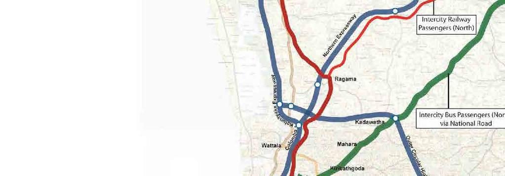
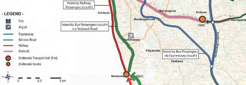
56 Figure Inter-city Passenger Public Transport Systems 69


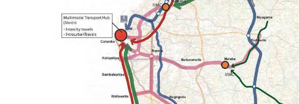
57 The intercity passenger public transport system is connected with the urban transport systems at the Multi-modal Transport Hubs and Multi Modal Centres. Passengers from outside of the metropolitan area transfer at these transport nodes and go to final destinations by urban transport systems in the metropolitan area as shown in Figure Figure Urban Passenger Public Transport Systems 70
Draft Urban Transport Master Plan for Colombo Metropolitan Region and Suburbs
 Draft Urban Transport Master Plan for Colombo Metropolitan Region and Suburbs Draft Version December, 2013 Scope of Urban Transport Master Plan Land Use & Urban Structure 1. Formulation of Suitable Urban
Urban Transport System Development Program (1) for Promotion of Public Transport Use
 for Promotion of Public Transport Use") CHAPTER 9 Urban Transport System Development Program (1) for Promotion of Public Transport Use The urban transport system development program (1) consists of the projects for the urban transport policy
CHAPTER 9 Urban Transport System Development Program (1) for Promotion of Public Transport Use The urban transport system development program (1) consists of the projects for the urban transport policy
URBAN TRANSPORT SYSTEM DEVELOPMENT PROJECT
 DEMOCRATIC SOCIALIST REPUBLIC OF SRI LANKA MINISTRY OF TRANSPORT URBAN TRANSPORT SYSTEM DEVELOPMENT PROJECT FOR COLOMBO METROPOLITAN REGION AND SUBURBS URBAN TRANSPORT MASTER PLAN FINAL REPORT SUMMARY
PREPARATORY SURVEY FOR NEW INTEGRATED URBAN PUBLIC TRANSPORT SYSTEM INTRODUCTION PROJECT FINAL REPORT
 MINISTRY OF TRANSPORT THE DEMOCRATIC SOCIALIST REPUBLIC OF SRI LANKA PREPARATORY SURVEY FOR NEW INTEGRATED URBAN PUBLIC TRANSPORT SYSTEM INTRODUCTION PROJECT FINAL REPORT JANUARY 2015 JAPAN INTERNATIONAL
PREPARATORY SURVEY FOR NEW INTEGRATED URBAN PUBLIC TRANSPORT SYSTEM INTRODUCTION PROJECT FINAL REPORT SUMMARY
 MINISTRY OF TRANSPORT THE DEMOCRATIC SOCIALIST REPUBLIC OF SRI LANKA PREPARATORY SURVEY FOR NEW INTEGRATED URBAN PUBLIC TRANSPORT SYSTEM INTRODUCTION PROJECT FINAL REPORT SUMMARY JANUARY 2015 JAPAN INTERNATIONAL
Ex-Ante Evaluation (for Japanese ODA Loan)
") Ex-Ante Evaluation (for Japanese ODA Loan) 1. Name of the Project Country: The Democratic Socialist Republic of Sri Lanka Project: Greater Colombo Urban Transport Development Project Phase 2 (II) Loan
Ex-Ante Evaluation (for Japanese ODA Loan) 1. Name of the Project Country: The Democratic Socialist Republic of Sri Lanka Project: Greater Colombo Urban Transport Development Project Phase 2 (II) Loan
SECTOR ASSESSMENT (SUMMARY): URBAN TRANSPORT 1
: URBAN TRANSPORT 1") Greater Dhaka Sustainable Urban Transport Project (RRP BAN 42169) Sector Road Map SECTOR ASSESSMENT (SUMMARY): URBAN TRANSPORT 1 1. Sector Performance, Problems, and Opportunities 1. Dhaka, the capital
Greater Dhaka Sustainable Urban Transport Project (RRP BAN 42169) Sector Road Map SECTOR ASSESSMENT (SUMMARY): URBAN TRANSPORT 1 1. Sector Performance, Problems, and Opportunities 1. Dhaka, the capital
Project No 2 CONSTRUCTION OF MULTI MODAL TRANSPORT HUB (MMTH) COLOMBO FORT/PETTAH
 COLOMBO FORT/PETTAH") Project No 2 CONSTRUCTION OF MULTI MODAL TRANSPORT HUB (MMTH) COLOMBO FORT/PETTAH 1. Project implementation agency: Urban Development Authority 2. Estimated project cost; US $ 7 billion 3. Method of procurement:
Project No 2 CONSTRUCTION OF MULTI MODAL TRANSPORT HUB (MMTH) COLOMBO FORT/PETTAH 1. Project implementation agency: Urban Development Authority 2. Estimated project cost; US $ 7 billion 3. Method of procurement:
DEVELOPMENT OF A MULTI-MODAL TRANSPORT CENTER FOR SUSTAINABLE URBAN TRANSPORT - A CASE STUDY IN COLOMBO METROPOLITAN AREA -
 DEVELOPMENT OF A MULTI-MODAL TRANSPORT CENTER FOR SUSTAINABLE URBAN TRANSPORT - A CASE STUDY IN COLOMBO METROPOLITAN AREA - Hirohisa KAWAGUCHI, Oriental Consultants Global Co., Ltd, kawaguchih@oriconsul.com
DEVELOPMENT OF A REGIONAL TRANSPORT PLAN: CASE STUDY OF PROPOSED HORANA GROWTH CENTER
 DEVELOPMENT OF A REGIONAL TRANSPORT PLAN: CASE STUDY OF PROPOSED HORANA GROWTH CENTER Amal S Kumarage, J Baratha Dodankotuwa, Ravindra Wijesundara, and Namali Sirisoma Department of Civil Engineering,
THE STUDY ON THE URBAN TRANSPORT DEVELOPMENT OF THE COLOMBO METROPOLITAN REGION
 No. THE DEMOCRATIC SOCIALIST REPUBLIC OF SRI LANKA MINISTRY OF RAILWAYS AND TRANSPORT MINISTRY OF HIGHWAYS ROAD DEVELOPMENT AUTHORITY THE STUDY ON THE URBAN TRANSPORT DEVELOPMENT OF THE COLOMBO METROPOLITAN
Sustainable Urban Mobility Planning. Dr. Toe Aung Director of Urban Planning Division Yangon City Development Committee
 Sustainable Urban Mobility Planning Dr. Toe Aung Director of Urban Planning Division Yangon City Development Committee Background and Objectives Yangon City, with a population of about 5.21 million as
Ex-Ante Evaluation (for Japanese ODA Loan)
") Ex-Ante Evaluation (for Japanese ODA Loan) 1. Name of the Project Country: The People s Republic of Bangladesh Project: Dhaka Mass Rapid Transit Development Project (Line 1) (E/S) Loan Agreement: June
Ex-Ante Evaluation (for Japanese ODA Loan) 1. Name of the Project Country: The People s Republic of Bangladesh Project: Dhaka Mass Rapid Transit Development Project (Line 1) (E/S) Loan Agreement: June
Japanese ODA. Ex-ante Evaluation
 Japanese ODA Ex-ante Evaluation 1. Name of the Project Country: The Socialist Republic of Vietnam Project: North-South Expressway Construction Project (Da Nang Quang Ngai Section) (I) (II) (III) L/A signed
ASSESSING THE PARADIGM SHIFT IN SRI LANKA S DEVELOPMENT OF THE TRANSPORT SECTOR
 ASSESSING THE PARADIGM SHIFT IN SRI LANKA S DEVELOPMENT OF THE TRANSPORT SECTOR AMAL S. KUMARAGE UNIVERSITY OF MORATUWA KUMARAGE@SLTNET.LK AMALK@UOM.LK 30th January 2014 Public Lecture Central Bank of
1. Name of the Project 2. Necessity and Relevance of JBIC Assistance 1. Situation and issues of the road sector in Sri Lanka
 Ex-ante Evaluation 1. Name of the Project Country: The Democratic Socialist Republic of Sri Lanka Project: Southern Highway Construction Project II Loan Agreement: July 29, 2008 Loan Amount: 17,499 million
Ex-Ante Evaluation (for Japanese ODA Loan)
") Japanese ODA Loan Ex-Ante Evaluation (for Japanese ODA Loan) 1. Name of the Project Country: The People s Republic of Bangladesh Project: Dhaka Mass Rapid Transit Development Project (Line 5) (E/S) Loan
Japanese ODA Loan Ex-Ante Evaluation (for Japanese ODA Loan) 1. Name of the Project Country: The People s Republic of Bangladesh Project: Dhaka Mass Rapid Transit Development Project (Line 5) (E/S) Loan
Ex-Ante Evaluation (for Japanese ODA Loan)
") Japanese ODA Loan Ex-Ante Evaluation (for Japanese ODA Loan) 1. Name of the Project Country: The People's Republic of Bangladesh Project: Dhaka Urban Transport Development Project (I) Loan Agreement: February
Japanese ODA Loan Ex-Ante Evaluation (for Japanese ODA Loan) 1. Name of the Project Country: The People's Republic of Bangladesh Project: Dhaka Urban Transport Development Project (I) Loan Agreement: February
WELLINGTON NORTHERN CORRIDOR. Project Summary Statement 21 December 2009
 WELLINGTON NORTHERN CORRIDOR Project Summary Statement 21 December 2009 1 Table of Contents 1. Purpose of Document 2. Strategic Context 3. Benefits 4. Project Scope and Economics 5. Implementation Plan
Japanese ODA loan. Ex-ante Evaluation
 Japanese ODA loan Ex-ante Evaluation 1.Name of the Project Country: The Socialist Republic of Vietnam Project: North-South Expressway Construction Project (Da Nang Quang Ngai Section)(I) L/A signed on:
TRANSPLAN V2: A REGIONAL TRAFFIC ESTIMATION MODEL
 TRANSPLAN V2: A REGIONAL TRAFFIC ESTIMATION MODEL Paper Presented at the Engineering Research Symposium, University of Moratuwa Amal S. Kumarage; J.M.S.J. Bandara; I.K. Weratne and M.G.G. Vidyarathne,
Chapter 6 Freight Plan
 Chapter 6 Freight Plan Overview This chapter presents a review and assessment of needs, deficiencies, policies and improvement options affecting the freight transportation system within the Medford Urban
Niagara s Transportation Strategy 1. Introduction:
 Niagara s Transportation Strategy May 8, 2002 Niagara s Transportation Strategy 1. Introduction: Transportation is of pivotal importance in the development of Niagara. This, Niagara s first comprehensive
Intergovernmental Tenth Regional Environmentally Sustainable Transport (EST) Forum in Asia
 Forum in Asia") 10 th Regional EST Forum in Asia, 14-16 March 2017, Vientiane, Lao PDR Intergovernmental Tenth Regional Environmentally Sustainable Transport (EST) Forum in Asia 2030 Road Map for Sustainable Transport
10 th Regional EST Forum in Asia, 14-16 March 2017, Vientiane, Lao PDR Intergovernmental Tenth Regional Environmentally Sustainable Transport (EST) Forum in Asia 2030 Road Map for Sustainable Transport
Ex-Ante Evaluation (for Japanese ODA Loan)
") Japanese ODA Loan Ex-Ante Evaluation (for Japanese ODA Loan) 1. Name of the Project Country: Federative Republic of Brazil Project: Belem Metropolitan Trunk Bus System Project Loan Agreement: September
Japanese ODA Loan Ex-Ante Evaluation (for Japanese ODA Loan) 1. Name of the Project Country: Federative Republic of Brazil Project: Belem Metropolitan Trunk Bus System Project Loan Agreement: September
Transportation Problems and Issues Excerpts from WWW Links
 Transportation Problems and Issues Excerpts from WWW Links Reference Bok, D. (2018). Transportation policy and planning. https://www.hks.harvard.edu/courses/transportation-policy-and-planning Transportation
Northern Virginia Region Draft Needs Summary
 Needs Map: Need A A DEMAND The ability of communities around transit stations (particularly the areas within 1-2 miles of the stations and other travel hubs) to attract skilled workers and grow businesses
SECTOR ASSESSMENT (SUMMARY): TRANSPORT
: TRANSPORT") Country Partnership Strategy: Pakistan, 2015 2019 SECTOR ASSESSMENT (SUMMARY): TRANSPORT Sector Road Map 1. Sector Performance, Problems, and Opportunities 1. Sector performance and problems. The transport
Country Partnership Strategy: Pakistan, 2015 2019 SECTOR ASSESSMENT (SUMMARY): TRANSPORT Sector Road Map 1. Sector Performance, Problems, and Opportunities 1. Sector performance and problems. The transport
Karachi Transportation Improvement Project. Table Number of Trips by Mode
 (3) Future Modal Share The next step is to distribute the trips in the estimated OD matrix into each mode: walking, motorbike, car and public transport, by applying the three modal split models. The modal
PROPOSED LOGISTIC PARK AT WELISARA
 2017 PROPOSED LOGISTIC PARK AT WELISARA CONCEPTUAL PLAN Contents 1. Introduction... 2 2. Goals of the Proposed Logistic Park... 4 3. Objectives of the Proposed Logistic Park... 5 4. Components expected
Liverpool City Region Candidate Major Schemes April 2013
 Region Candidate April 2013 Sponsoring Halton Borough Halton Borough Halton Borough Scheme Name: Detail: Estimated Silver Jubilee Bridge Major Maintenance M56 J11A Daresbury Enterprise Zone / East Runcorn
TransPlan TransPlan v1 for CMC area (1995) TransPlan v2 for Western Province (1998) TransPlan v3 for A & B Sri Lanka (2001) TransPlan v4 for A & B Sri
 TransPlan v2 for Western Province (1998) TransPlan v3 for A & B Sri Lanka (2001) TransPlan v4 for A & B Sri") TransPlan V5 Traffic Forecasting Model Amal S. Kumarage University of Moratuwa 2005 TransPlan TransPlan v1 for CMC area (1995) TransPlan v2 for Western Province (1998) TransPlan v3 for A & B Sri Lanka
TransPlan V5 Traffic Forecasting Model Amal S. Kumarage University of Moratuwa 2005 TransPlan TransPlan v1 for CMC area (1995) TransPlan v2 for Western Province (1998) TransPlan v3 for A & B Sri Lanka
INDIANA S INTERMODAL MANAGEMENT SYSTEM Stephen C. Smith Planning Manager, Transportation Planning Division Indiana Department of Transportation
 96 INDIANA S INTERMODAL MANAGEMENT SYSTEM Stephen C. Smith Planning Manager, Transportation Planning Division Indiana Department of Transportation Indiana is in the process of developing an Intermodal
The Victorian Transport Plan (Department of Transport, 2008).
.") 18 TRANSPORT Planning should ensure an integrated and sustainable transport system that provides access to social and economic opportunities, facilitates economic prosperity, contributes to environmental
18 TRANSPORT Planning should ensure an integrated and sustainable transport system that provides access to social and economic opportunities, facilitates economic prosperity, contributes to environmental
Capacity Building Workshop on Sustainable Urban Transport Index st Oct. 2017, Colombo, Srilanka.
 Capacity Building Workshop on Sustainable Urban Transport Index Piloting Sustainable Urban Transport Index in Kathmandu Valley towards Implementation of Sustainable Urban Transport. 30-31st Oct. 2017,
GLOBELINK A STRONG PLAN FOR REAL CHANGE 1
 GLOBELINK A STRONG PLAN FOR REAL CHANGE 1 We re ready. Over the last four years, we ve been working hard developing our vision for the future of South Australia. Not just policies, but a series of achievable
Intergovernmental Eleventh Regional Environmentally. Sustainable Transport (EST) Forum in Asia. 2-5 October 2018 Ulaanbaatar, Mongolia
 Forum in Asia. 2-5 October 2018 Ulaanbaatar, Mongolia") Intergovernmental Eleventh Regional Environmentally Sustainable Transport (EST) Forum in Asia 2-5 October 2018 Ulaanbaatar, Mongolia Sustainable Urban Design and Development ~ Role of EST Country Report
Intergovernmental Eleventh Regional Environmentally Sustainable Transport (EST) Forum in Asia 2-5 October 2018 Ulaanbaatar, Mongolia Sustainable Urban Design and Development ~ Role of EST Country Report
IPSWICH NORTHERN ROUTES STUDY. Stage 1 Progress
 IPSWICH NORTHERN ROUTES STUDY Stage 1 Progress 17 th January 2017 STUDY CONTEXT 2 The study is being funded in partnership with the Suffolk district and borough councils. Work forms part of the Suffolk
Ex-ante Evaluation 1. Name of the Project 2. Background and Necessity of the Project
 Ex-ante Evaluation 1. Name of the Project Country: India Project Title: Hyderabad Outer Ring Road Project (Phase 2) Loan Agreement: November 21, 2008 Loan Amount: 42,027 million Yen Borrower: The President
Economic Analysis of Public Policy Graduate School of Public Policy, University of Tokyo. Final Report
 Economic Analysis of Public Policy 2014 Graduate School of Public Policy, University of Tokyo Final Report Southern Expressway in Sri Lanka: A Cost Benefit Analysis Aswathi John K Graduate School of Public
Contents i Contents Page 1 A New Transportation Plan Community Involvement Goals and Objectives... 11
 Contents i Contents 1 A New Transportation Plan... 1 Why develop a new plan?... 1 What area does the LRTP focus on?... 2 Why is this LRTP important?... 3 Meeting Requirements for Transportation Planning...
SECTOR ASSESSMENT (SUMMARY): TRANSPORT, AND INFORMATION AND COMMUNICATION TECHNOLOGY. 1. Sector Performance, Problems, and Opportunities
: TRANSPORT, AND INFORMATION AND COMMUNICATION TECHNOLOGY. 1. Sector Performance, Problems, and Opportunities") Hubei Yichang Sustainable Urban Transport Project (RRP PRC 45023) SECTOR ASSESSMENT (SUMMARY): TRANSPORT, AND INFORMATION AND COMMUNICATION TECHNOLOGY A. Sector Road Map 1. Sector Performance, Problems,
Hubei Yichang Sustainable Urban Transport Project (RRP PRC 45023) SECTOR ASSESSMENT (SUMMARY): TRANSPORT, AND INFORMATION AND COMMUNICATION TECHNOLOGY A. Sector Road Map 1. Sector Performance, Problems,
Ex-Ante Evaluation (for Japanese ODA Loan)
") Ex-Ante Evaluation (for Japanese ODA Loan) 1. Name of the Project Country: The People s Republic of Bangladesh Project: The Kanchpur, Meghna and Gumti 2nd Bridges Construction and Existing Bridges Rehabilitation
Ex-Ante Evaluation (for Japanese ODA Loan) 1. Name of the Project Country: The People s Republic of Bangladesh Project: The Kanchpur, Meghna and Gumti 2nd Bridges Construction and Existing Bridges Rehabilitation
NEED ECONOMIC TRANSPORTATION LOCATIONS EXAMPLE
 A. Enhance multimodal networks and facilities around transit access points such as existing and emerging rail stations, high capacity bus stops, and intermodal transfer centers There is a need for improved
Seminar on Importance of Transport Infrastructure for National Development Chamber of Construction Industry 26th August 2008
 Amal S. Kumarage kumarage@sltnet.lk Seminar on Importance of Transport Infrastructure for National Development Chamber of Construction Industry 26th August 2008 Constraints for Development Infrastructure
Content of the module
 Content of the module Methodology approach Planning process Definition of working area Population and territorial context Supply Infrastructure Transport service Demand On board / at the stations or bus
Sample TOR for CMP Preparation
 Annex 6 Sample TOR for CMP Preparation This annex provides a sample terms of reference (TOR) for use in appointing consultants to assist with the preparation of a CMP. The TOR should be amended where necessary
NAMASKAR and Good Morning from the country of Mt. Everest and Buddha
 NAMASKAR and Good Morning from the country of Mt. Everest and Buddha Strengthening Integrated Intermodal Transport Connectivity for Southeast and South-Southwest Asia Country presentations on policies,
Benefit Cost Analysis Narrative
 Chicago Region Environmental and Transportation Efficiency Program (CREATE) Grade Separations of: GS21a - Union Pacific and 95 th Street GS11 - Belt Railway Company of Chicago and Columbus Ave. GS 9 -
GLOBE LINK CONNECTING SOUTH AUSTRALIA TO THE WORLD
 GLOBE LINK CONNECTING SOUTH AUSTRALIA TO THE WORLD 2036 WILL MARK OUR STATE S BICENTENARY By the time our State turns 200 years old, I want South Australia to be a place of prosperity. Planning and delivering
Illawarra Business Chamber/Illawarra First. Submission on NSW Draft Freight and Ports Plan
 Illawarra Business Chamber/Illawarra First Submission on NSW Draft Freight and Ports Plan Illawarra Business Chamber A division of the NSW Business Chamber Level 1, 87-89 Market Street WOLLONGONG NSW 2500
7 Infrastructure Development Plan
 7 Infrastructure Development Plan 7.1 Roads and Public Transport 7.1.1 Sector Overview Major industrial linkage to/from Krishnapatnam node will be developed with Bengaluru, Chennai, Vijaywada, Guntur,
Sustainable Transportation & Land Use Integration Study
 Sustainable Transportation & Land Use Integration Study Stakeholders Group Meeting Two Includes additions made after meeting March 28, 2011 Hot Topics: Emerging themes, technologies, and techniques Outline
Assessing the paradigm shift in Sri Lanka's development of the transport sector. 1. Identifying the Changing Demand Function for Transport
 Assessing the paradigm shift in Sri Lanka's development of the transport sector 1. Identifying the Changing Demand Function for Transport A country requires transport for a multitude of different functions.
CASE STUDY 5. Extension of the Adriatic-Ionian ferry corridor from Peloponnese to Crete" University of the Aegean Dpt. Shipping, Trade & Transport
 Lisbon, 15 December 2011 CASE STUDY 5 Extension of the Adriatic-Ionian ferry corridor from Peloponnese to Crete" University of the Aegean Dpt. Shipping, Trade & Transport The concept of the Case Study
Niagara Region Transportation Master Plan Niagara-Hamilton Trade Corridor Technical Paper
 Niagara-Hamilton Trade Corridor Technical Paper 1. Purpose In the report to Council on the Regional Council Strategic Priorities Implementation Plan, pursuing Provincial commitment for the Niagara to Greater
PROPOSED CAIRO URBAN TRANSPORT STRATEGY & PRIORITY PROGRAM
 PROPOSED CAIRO URBAN TRANSPORT STRATEGY & PRIORITY PROGRAM Greater Cairo Development Project Proposed Cairo Urban Transport Strategy & Priority Program Ministry of Housing World Bank General Organization
Concept of Sustainable Transport: Planning and Designing for Sustainable and Inclusive Transportation Systems UNESCAP Transport Division
 National Capacity Building Workshop on Sustainable and Inclusive Transport Development Colombo, Sri Lanka 9-10 July 2015 Concept of Sustainable Transport: Planning and Designing for Sustainable and Inclusive
Chapter 10 Goals, Objectives + Policies
 Chapter 10 Goals, + Policies Warehouse on Nestle Way near I-78 114 115 10.1 ESTABLISHMENT OF CONSISTENT GOALS 10.2 NATIONAL FREIGHT GOALS The Lehigh Valley s freight transportation investment decisions
Evaluation of Alternatives
 Chapter 9.0 Evaluation of Alternatives Chapter 9.0 provides a summary evaluation of the No Build Alternative and the Preferred Alternative. The evaluation contained within this chapter is an assessment
Ex-ante Evaluation - 1 -
 Ex-ante Evaluation 1. Name of the Project Country: The Socialist Republic of Vietnam Project: The North-South Expressway Construction Project (Ho Chi Minh City Dau Giay) (I) (Loan Agreement: March 31,
Chapter 9: Vision Plan. Chapter 9. Vision Plan. Lake Loveland. Image 179 Credit: City of Loveland
 Chapter 9 Vision Plan Lake Loveland. Image 179 Credit: City of Loveland Chapter 9: Vision Plan A. Regionally Significant Corridor and Regional Bike Corridor Visions Corridor visioning seeks to develop
FLORIDA DEPARTMENT OF TRANSPORTATION PROCEDURE DEVELOPMENT OF THE
 FLORIDA DEPARTMENT OF TRANSPORTATION PROCEDURE DEVELOPMENT OF THE FLORIDA INTRASTATE HIGHWAY SYSTEM Topic No.: 525-030-250-f Office: Systems Planning Effective Date: May 16, 2002 DEVELOPMENT OF THE FLORIDA
Findings to Date UBC LINE RAPID TRANSIT ALTERNATIVES ANALYSIS 1. UBC Line Rapid Transit Alternatives Analysis Findings to Date
 Findings to Date LINE RAPID TRANSIT ALTERNATIVES ANALYSIS 1 Line Rapid Transit Alternatives Analysis Findings to Date March 2013 Findings to Date LINE RAPID TRANSIT ALTERNATIVES ANALYSIS 2 This document
Review of Sri Lanka Transport Sector
 Review of Sri Lanka Transport Sector FINAL REPORT AMAL S. KUMARAGE Assisted by Tissa Liyanage, 1 Janaka Weerawardena and Pradeepa Jayaratne 31/07/ TABLE OF CONTENTS EXECUTIVE SUMMARY Introduction Growth
Massachusetts Rail Plan. September 16, 2010
 Massachusetts Rail Plan September 16, 2010 State Freight and Rail Plans State Rail Plan The plan describes state policy for freight and passenger rail transportation, including commuter rail Provides priorities
10. PROJECT DEVELOPMENT, LEADERSHIP, AND OVERSIGHT GUIDELINES
 10. PROJECT DEVELOPMENT, LEADERSHIP, AND OVERSIGHT GUIDELINES It is important to note that the Transitway Guidelines are not intended to be prescriptive, but rather to provide a consistent basis for planning,
WORKSHOP ON NATIONAL CAPACITY BUILDING FOR SUSTAINABLE TRANSPORT COLOMBO, SRI LANKA JULY 2015
 WORKSHOP ON NATIONAL CAPACITY BUILDING FOR SUSTAINABLE TRANSPORT COLOMBO, SRI LANKA 09-10 JULY 2015 SUMANT CHAK DIRECTOR(INTERNATIONAL RELATIONS) ASIAN INSTITUTE OF TRANSPORT DEVELOPMENT, NEW DELHI Organisations
SOUTHWEST LRT (METRO GREEN LINE EXTENSION)
") 8 Evaluation of Alternatives This chapter evaluates the effectiveness of the No Build Alternative and the Southwest Light Rail Transit (LRT) Project (the Project) based on the information contained in
8 Evaluation of Alternatives This chapter evaluates the effectiveness of the No Build Alternative and the Southwest Light Rail Transit (LRT) Project (the Project) based on the information contained in
South East Transport Strategy
 South East Transport Strategy Executive Summary August 2018 www.jacobs.com worldwide The strategy The South East Transport Strategy is a plan for the region s transport network over the next 10 years.
2040 Transportation Policy Plan Conversion to Performance Based Planning Basis. 25 th Annual CTS Transportation Research Conference May 21, 2014
 2040 Transportation Policy Plan Conversion to Performance Based Planning Basis 25 th Annual CTS Transportation Research Conference May 21, 2014 1 About the plan Long-range transportation plan for the Twin
Workshop on enabling Inclusive Cities ADB 29 October PAKISTAN: Karachi Mass-Transit Project (KMTP)
") Workshop on enabling Inclusive Cities ADB 29 October 2013 PAKISTAN: Karachi Mass-Transit Project (KMTP) Agenda 1. Karachi - Context 2. Rapid Project Description 3. Urban Transport and Inclusiveness: Different
Workshop on enabling Inclusive Cities ADB 29 October 2013 PAKISTAN: Karachi Mass-Transit Project (KMTP) Agenda 1. Karachi - Context 2. Rapid Project Description 3. Urban Transport and Inclusiveness: Different
6.0 CONGESTION HOT SPOT PROBLEM AND IMPROVEMENT TRAVEL DEMAND MODEL ANALYSIS
 6.0 CONGESTION HOT SPOT PROBLEM AND IMPROVEMENT TRAVEL DEMAND MODEL ANALYSIS 6.1 MODEL RUN SUMMARY NOTEBOOK The Model Run Summary Notebook (under separate cover) provides documentation of the multiple
Ex-Ante Evaluation (for Japanese ODA Loan)
") Japanese ODA Loan Ex-Ante Evaluation (for Japanese ODA Loan) 1. Name of the Project Country: The Republic of Indonesia Project: Construction of Jakarta Mass Rapid Transit Project (II) Loan Agreement: December
Japanese ODA Loan Ex-Ante Evaluation (for Japanese ODA Loan) 1. Name of the Project Country: The Republic of Indonesia Project: Construction of Jakarta Mass Rapid Transit Project (II) Loan Agreement: December
407 TRANSITWAY - KENNEDY ROAD TO BROCK ROAD MINISTRY OF TRANSPORTATION - CENTRAL REGION
 Executive Summary 407 TRANSITWAY - KENNEDY ROAD TO BROCK ROAD MINISTRY OF TRANSPORTATION - CENTRAL REGION E. EXECUTIVE SUMMARY E.1. E.1.1. Background 407 Transitway Background and Status The planned 407
Fishermans Bend Integrated Transport Plan Peer Review John Kiriakidis, GTA Consultants 28/03/2018
 Fishermans Bend Integrated Transport Plan Peer Review John Kiriakidis, GTA Consultants 28/03/2018 GTA creating transport that works 01 Preliminaries GTA creating transport that works Review scope : Review
POLK COUNTY TPO Polk County 2060 Transportation Vision Plan Final Report. ADOPTED June 18, 2009
 POLK COUNTY TPO Polk County 2060 Transportation Vision Plan Final Report ADOPTED June 18, 2009 TABLE OF CONTENTS CHAPTER 1 Introduction and Prior Planning Effort...Page 1-1 CHAPTER 2 Population and Employment
Weerawardana & Kumarage 293
 Weerawardana & Kumarage 293 SYSTEM COST ESTIMATION FOR AN URBAN MULTI-MODAL TRANSPORT CORRIDOR J. WEERAWARDANA a and A.S. KUMARAGE b a Department of Transport & Logistics Management, University of Moratuwa,
Report to: Greater Cambridge Partnership Joint Assembly 18 January 2018
 Report to: Greater Cambridge Partnership Joint Assembly 18 January 2018 Lead officer: Chris Tunstall Greater Cambridge Partnership Recommendations from the Ely to Cambridge A10 Transport Study and proposed
A Better Connected South Hampshire
 A Better Connected South Hampshire DfT Local Sustainable Transport Fund Bid December 2011 Executive Summary Executive Summary Transport for South Hampshire (TfSH) is delighted to submit a business case
TRANSPORT SYSTEM IN URBAN INDIA
 MULTI MODAL TRANSPORT SYSTEM IN URBAN INDIA Pawan Kumar, Asstt TCP, Town & Country Planning Organization,, MoUD, New Delhi 1 Urban India(2001) Total Urban Population = 286.11 million = 27.78 % of total
Appendix A: Project Planning and Development A-1 White Paper on Transit and the Tappan Zee Hudson River Crossing Project
 Appendix A: Project Planning and Development A-1 White Paper on Transit and the Tappan Zee Hudson River Crossing Project Purpose of White Paper White Paper on Transit and the Tappan Zee Hudson River Crossing
Freight transport policy and measures in Norway
 PIARC meeting and seminar 13-15 June 2005 in Ouagadougou Freight transport policy and measures in Norway Senior Adviser Hans Silborn, Norwegian Public Roads Administration Norway is a sparsely inhabited
TRANSPORTATION MASTER PLAN DRAFT A TARGET TRANSIT MODE SHARE STRATEGY TECHNICAL MEMORANDUM # 1
 TRANSPORTATION MASTER PLAN DRAFT A TARGET TRANSIT MODE SHARE STRATEGY TECHNICAL MEMORANDUM # 1 16 FEBRUARY 2010 TABLE OF CONTENTS 1 INTRODUCTION... 1 2 EXPERIENCE With target transit mode shares... 2 2.1
VTrans2040 Multimodal Transportation Plan Corridors of Statewide Significance Needs Assessment Western Mountain Corridor (L)
") VTrans2040 Multimodal Transportation Plan Corridors of Statewide Significance Needs Assessment Western Mountain Corridor (L) 77 Table of Contents I. Corridor Overview Land Use and Demographics Corridor
VTrans2040 Multimodal Transportation Plan Corridors of Statewide Significance Needs Assessment Western Mountain Corridor (L) 77 Table of Contents I. Corridor Overview Land Use and Demographics Corridor
Infrastructure and Growth Leadership Advisory Group Ideas and Approaches Survey
 Infrastructure and Growth Leadership Advisory Group Ideas and Approaches Survey Maintain transportation system in state of good repair 1. Increase focus on maintenance of existing infrastructure in poor
Retour au sommaire. Back to menu
 1 Kamal Shoar (KamalShoar@yahoo.co.uk) Director, Tarh-e-Haftom Consulting Engineers Leila Kazemnezhad Leila Kazemnezhad (leilakazemnezhad@gmail.com) Senior transport consultant, Tarh-e-Haftom Consulting
RAILWAY BASED CONTAINER TRANSPORTATION TO GREENING SUPPLY CHAINS: A CASE STUDY IN SRI LANKA
 RAILWAY BASED CONTAINER TRANSPORTATION TO GREENING SUPPLY CHAINS: A CASE STUDY IN SRI LANKA K.D.P.R Jayatilaka 1, L.Y.D.J Abanwela 2, K.W.D.W.S. Dahanayake 3, A.K. Kulatunga 4, U.S.S Dharmapriya 5 1 Dept.
AMPO Annual Conference Session: Performance (Part 1) October 18, 2017 Savannah, GA
 October 18, 2017 Savannah, GA") AMPO Annual Conference Session: Performance (Part 1) October 18, 2017 Savannah, GA Introduction: North Jersey Transportation Planning Authority NJTPA Congestion Management Process Study Goals Analysis
AMPO Annual Conference Session: Performance (Part 1) October 18, 2017 Savannah, GA Introduction: North Jersey Transportation Planning Authority NJTPA Congestion Management Process Study Goals Analysis
Summary of transportation-related goals and objectives from existing regional plans
 SMTC 2050 Long Range Transportation Plan Appendix A: Summary of transportation-related goals and objectives from existing regional plans SMTC 2050 Long Range Transportation Plan Summary of transportation-related
Proposed Comprehensive Update to the State of Rhode Island s Congestion Management Process
 Proposed Comprehensive Update to the State of Rhode Island s Statewide Planning Program January 2018 Summary Outline of of Action Steps 1. Develop Objectives for Congestion Management What is the desired
AUSTRALASIAN RAILWAY ASSOCIATION SUBMISSION
 AUSTRALASIAN RAILWAY ASSOCIATION SUBMISSION To The House of Representatives Standing Committee on Infrastructure, Transport and Cities On Australian Government s role in the development of cities Sub-Inquiry
Maharashtra Rail Infrastructure Development Limited. Pune Nasik Double Line
 Maharashtra Rail Infrastructure Development Limited (MRIDL) Name of the project Pune Nasik Double Line (With electrification) Term of Reference For Traffic Study and Financial Analysis for Green Field
Call For Papers: 13th EASTS (Eastern Asia Society for Transportation Studies) Conference in Colombo, Sri Lanka, September 9-12, 2019 CALL FOR PAPERS
 Conference in Colombo, Sri Lanka, September 9-12, 2019 CALL FOR PAPERS") CALL FOR PAPERS 13th EASTS Conference in Colombo, Sri Lanka I. General Information 1. Conference Schedule and Venue Date: Venue: Colombo, Sri Lanka 2. Notification: Paper Reviewing Process Reviewed Papers:
CALL FOR PAPERS 13th EASTS Conference in Colombo, Sri Lanka I. General Information 1. Conference Schedule and Venue Date: Venue: Colombo, Sri Lanka 2. Notification: Paper Reviewing Process Reviewed Papers:
2004 FEASIBILITY STUDY UPDATE
 Austin-San Antonio Intermunicipal Commuter Rail District 2004 FEASIBILITY STUDY UPDATE December 2004 EXECUTIVE SUMMARY INTRODUCTION Almost 3 million people in Central Texas, living and working between
Ex-Ante Evaluation (for Japanese ODA Loan)
") Japanese ODA Ex-Ante Evaluation (for Japanese ODA Loan) 1. Name of the Project Country: The Republic of Indonesia Project: Engineering Services (E/S) for Construction of Jakarta Mass Rapid Transit East-West
Japanese ODA Ex-Ante Evaluation (for Japanese ODA Loan) 1. Name of the Project Country: The Republic of Indonesia Project: Engineering Services (E/S) for Construction of Jakarta Mass Rapid Transit East-West
EIGHT PLANNING FACTORS
 EIGHT PLANNING FACTORS Under the provisions of SAFETEA-LU, all Metropolitan Planning Organizations (MPOs) are required to consider eight (8) broad planning factors in the development of multi-modal transportation
Rail Freight and Passenger
 Take Care of the System Critical Investments in the areas of: Rail Freight rehabilitate rail bridges o Rail Bridge Inventory Database... $0.5 - $1.0 million (one time) Rail Freight rail replacement and
GUIDE FOR THE PREPARATION OF TRAFFIC IMPACT STUDIES
 GUIDE FOR THE PREPARATION OF TRAFFIC IMPACT STUDIES Adopted by Town Council on November 25, 2008 Prepared By: HNTB Engineering Department Planning Department TABLE OF CONTENTS I. INTRODUCTION... 1 II.
Passenger service for the Dudding Hill line: brief for feasibility study
 Appendix 1: Specification for a Study Passenger service for the Dudding Hill line: brief for feasibility study Introduction The West London Alliance is currently investigating ways of accommodating the