Oregon Department of Transportation. OR217: Active Traffic Management
|
|
|
- Wilfrid Brown
- 5 years ago
- Views:
Transcription


1 Oregon Department of Transportation OR217: Active Traffic Management Dec. 29, 2015
2 Table of Contents Executive Summary Introduction Travel Time Reliability Average Corridor Travel Time Crash Rates ADT Systems Overview Travel Time Queue Warning Congestion Responsive Variable Speed Weather Responsive Variable Speed and Weather Warning Curve Warning Central Ramp-Metering System (CRMS) Results Crash Rates ADT TT Reliability Avg TT System Adjustments Next Steps Appendix Contact Information Michael Burkart Oregon Department of Transportation Phone: (503) michael.burkart@odot.state.or.us 2 P age
3 Executive Summary Oregon Route 217 is a 7.5 mile limited access highway that runs north-south between US 26 and Interstate 5 through the cities of Beaverton and Tigard. Traffic on this highway has more than doubled over the last three decades, which has significantly degraded its safety and reliability, as it is operating at or above capacity. The Oregon Department of Transportation (ODOT) has focused on lower-cost safety and efficiency improvements due to limited public funding for expansion and improvement projects. To help address the increasing safety and reliability concerns, the OR217 Active Traffic Management (ATM) project was deployed in July, The OR217 ATM system is a comprehensive implementation of automated technologies to improve the operations and safety of the freeway system. ATM strategies improve traffic flow and safety using integrated systems and coordinated responses to dynamically managing traffic based on prevailing roadway conditions. The OR217 ATM project is composed of six systems that work together to address safety and reliability goals. These systems include Travel Time, Queue Warning, Congestion Responsive Variable Speed, Weather Responsive Variable Speed, Dynamic Ramp-Metering and Curve Warning. The following report evaluates the safety, mobility and reliability of the applied ATM strategies using the performance measures summarized below. Pre: 08/ /2014, Post: 08/ /2015, AM Peak 7-10, PM Peak 4-6 Total Combined: Total Crashes Table 1. Performance Measures Summary Volume (VPLPH) Avg TT (min) 95% TT (min) Buffer Time (min) % 5.07% 0.03% -5.01% % In this study, the effectiveness of the OR217 ATM system on the improvement of operational and safety goals was evaluated with real traffic data. The analysis results indicate there was a significant reduction in crashes and crash severity as well as improvements in reliability indices all while incurring an increase in peak period vehicles per lane per hour (VPLPH). 3 P age
4 1.0 Introduction OR 217 is a 7.5 mile limited access highway with closely spaced interchanges located in the Portland metropolitan area between US 26 and I-5. With over 122,000 vehicles per day, it often operates at or above capacity during both peak and off-peak hours with highly unpredictable traffic patterns. The total traffic volumes doubled between 1985 and 2005 and by 2025, traffic volumes are expected to increase by another 30%. The use of Active Traffic Management (ATM) strategies to manage existing transportation systems efficiently has increased as major capacity increases are limited by financial and land availability constraints, especially in urban areas. The OR217 ATM project was deployed in July, 2014 to help manage the transportation system by responding to prevailing road, traffic and weather conditions in real time, in order to increase safety and operational reliability. To achieve these goals, a synthesis of overlying systems and physical infrastructure were utilized to provide travelers with information to safely and efficiently travel throughout the corridor. Key performance measures to assess these goals were analyzed before and after the installation and implementation of the OR217 ATM project. These key performance measures include Crash Rates, VPLPH, Average Corridor Travel Time and Travel Time Reliability. 1.1 Travel Time Reliability Travel Time Reliability is defined through the relationship between 95 th, average, and free-flow weekday travel times on a (directional) corridor between defined start and end points. Objectives in the area of travel time reliability aim to reduce the variability in travel time so that transportation system users experience a consistent and predictable trip time and unexpected delay is reduced for people and goods travelling throughout the network. System reliability can be quantified using Travel Time index, Buffer Index and Planning Time index. The Travel time index indicates the average delay to free-flow conditions that can be expected along a corridor due to recurring congestion. The Buffer Time Index reflects the amount of extra time that travelers need to add to their average travel time to account for non-recurring delay. The planning time index illustrates the amount of extra time that travelers need to add to free-flow or posted speed limit travel time in order to arrive on-time for almost all situations. The planning time index takes into account both recurring and non-recurring sources of delay. These relationships are represented below in Figure 1. 4 P age
5 Travel Time (min) Reliability Measures Relationship Buffer Time Planning Time Index (PTI) Travel Time Index (TTI) Free-Flow Average 95% TOD Figure 1. Reliability Measures Relationship example 1.2 Average Corridor Travel Time Average Corridor Travel Time consists of the 50 th percentile (mean) travel time on a (directional) corridor between defined start and end points. Average travel times help establish baseline recurring congestion levels which are based on geometric limitations or lack of capacity. Average travel times are evaluated with 95 th percentile travel times to quantify reliability goals of the OR217 Active Traffic Management system. Traffic volumes are also assessed with average travel times to evaluate throughput objectives. 1.3 Crash Rates Crash rates were evaluated based on type, severity and roadway condition along defined segments of the treated corridors. One objective of the OR217 ATM system is to reduce the frequency and severity of crashes associated with congestion, unpredictable traffic queues or possible hazardous roadway conditions such as low visibility or slippery surfaces 1.4 ADT Vehicles per lane per hour (VPLPH) information was evaluated for directional peak periods along the corridor. 5 P age
6 Volumes were evaluated with average travel times to measure throughput objectives. Decreasing average travel times along with higher VPLPH s signify improvement in spatial variations between vehicles throughout a corridor. 2.0 Systems Overview The OR217 ATM project was composed of six systems that work together to address safety and reliability goals. These systems include Travel Time, Queue Warning, Congestion Responsive Variable Speed, Weather Responsive Variable Speed, Dynamic Ramp-Metering and Curve Warning. These systems interact together and share much of the same physical and informational infrastructure. The informational relationships are outlined below in Figure 2. Figure 2. ATM Information Flow Diagram 6 P age
7 System information is obtained and exhibited through physical infrastructure. The OR217 ATM system utilizes a robust set of sensors including Bluetooth, radar and inductive loop detectors to gather vehicle speed, occupancy and volume data along with roadway weather sensors to detect hazardous roadway conditions. This information is processed and distributed to the motorist by means of variable message and variable speed signs located throughout the corridor. Figure 3. ATM infrastructure Diagram The traveler information dispersed is described in the following sections. 7 P age


 systems are used to proactively manage vehicle speeds.")
8 2.1 Travel Time The Travel Time system calculates how long it should take drivers to reach common destinations using realtime traffic information. By providing travel time information, drivers can choose an alternate route or alter an existing trip. Travel time information also improves safety by alerting motorists to the potential level of congestion along a route. All variable message systems must meet driver expectations, be easily understood, relevant and up-to-date. 2.2 Queue Warning The Queue Warning system notifies drivers that slowing or stopped vehicles exist ahead signifying a reduction in expected speed. The primary purpose of the queue warning system is to alert drivers to the significant difference in speeds and considerably reduce the number and severity of crashes, especially rear-end type, that are related to unpredictable congestion throughout the corridor. 2.3 Congestion Responsive Variable Speed Variable Advisory Speed (VAS) systems are used to proactively manage vehicle speeds. This system automatically adjusts the advised speeds on the highway based on current downstream traffic conditions. The primary purpose of the Congestion Responsive Variable Speed system is to minimize the spatial and temporal variations in speed that can lead to additional crashes and increased congestion. 8 P age
 sensor data for corridor level roadway conditions.")

9 2.4 Weather Responsive Variable Speed and Weather Warning The Weather Responsive Variable Speed system automatically adjusts the advised speeds on the highway based on Roadway Weather Information Systems (RWIS) sensor data for corridor level roadway conditions. The primary purpose of the Weather Responsive Variable Speed system is to notify drivers of inclement weather and display appropriate advised speeds and weather warnings for possible hazardous roadway conditions such as low visibility or slippery surfaces. Speed reduction values are based on grip factor as outlined below in Figure 4. SSD Speed Limit Speed in icy conditions Speed in wet conditions Figure 4. Speed Reduction per Grip Factor Appropriate traveling speeds are based on visibility and grip factor values for various weather conditions. Weather speed categories are defined below in Table 2. 9 P age

 USE CAUTION USE CAUTION (None)* > 500' Frosty, Snowy, Icy, or Slushy N/A ICE USE CAUTION ICE USE CAUTION (None)* Moist or Wet LOW VISIBILITY USE CAUTION USE")
10 Weather Speed Lookup Table Grip Factor > > X > 0.30 < 0.30 Chain Requirement Visibility > 500' Speed Limit Speed Limit - 10 MPH Speed Limit - 20 MPH Chain Speed < 500' Speed Limit - 10 MPH Speed Limit - 20 MPH Minimum Speed Chain Speed Weather VMS Message Lookup Table Grip Factor Visibility Classification > > X > 0.30 < 0.30 Chain Requirement Moist or Wet (None) USE CAUTION USE CAUTION (None)* > 500' Frosty, Snowy, Icy, or Slushy N/A ICE USE CAUTION ICE USE CAUTION (None)* Moist or Wet LOW VISIBILITY USE CAUTION USE CAUTION USE CAUTION (None)* < 500' Frosty, Snowy, Icy, or Slushy LOW VISIBILITY USE CAUTION ICE USE CAUTION ICE USE CAUTION (None)* Table 2. Weather Speed Categories *Snow zone chain requirement messages for VMS will come from ATMS/TOCS 2.5 Curve Warning The Curve Warning system provides roadway surface information to motorists at localized high risk areas. The intent of the system is to lower motorists speeds accordingly by posting appropriate curve warning messages based on current pavement conditions. The primary goal of the Curve Warning system is to reduce the occurrence and severity of wet and icy weather crashes at these confined locations. 2.6 Central Ramp-Metering System (CRMS) The Central Ramp Meter Control System (CRMS) is an application that collects field data from station locations, processes this data, and distributes the data to appropriate applications. The system controls the dynamic ramp meter functionality through SWARM and includes user interface capabilities required to allow users to both monitor system performance and alter parameters as needed. 10 P age
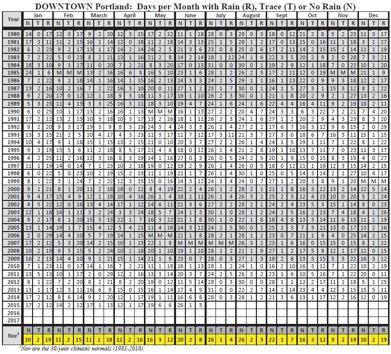
11 4.0 Results The effectiveness of the OR217 ATM system on the improvement of operational and safety goals was evaluated utilizing real traffic data. The results indicate a significant reduction in crashes and crash severity as well as improvements in reliability indices all while incurring an increase in peak period vehicles per lane per hour (VPLPH). 4.1 Crash Rates Crash data was collected from several independent sources including Transportation Data Services (TDS) Crash Reports and Washington County Consolidated Communications Agency (WCCCA) data. The information contained in the TDS Crash reports is compiled from individual driver and police crash reports submitted to the Oregon Department of Transportation as required in ORS TDS Crash reports are updated monthly with data currently available up to 12/31/2014. The crash data for the latest available year is preliminary and subject to change until finalized on approximately June 30 of the following calendar year. As shown below in Table 3, available TDS data indicates a reduction in total crashes with a significant (60%) reduction in severity. The targeted crash type (rear-end and side-swipe overtaking) associated with congestion were also reduced. Wet/Icy surface condition crashes increased by 17.5% but the number of days with rain recorded by the National Weather Service for downtown Portland during the same time periods evaluated increased from 51 days prior to OR217 ATM activation to 63 days after activation. The increase in days with rain is compounded by a nearly 55% increase in precipitation levels over the same period. Not only did it rain more often, it rained harder. ODOT TDS data: Total Crashes Severity: Fatal/InjA Colision Type: Rear/SS-O Surface Condition: Ice/Wet Pre 7/22/ /31/ Post 7/22/ /31/ % -60.0% -18.6% *17.5% * Time period evaluated includes 23% increase in Days/Month with Rain & 55% increase in Precipitation levels Table 3. TDS Crash Results Crash data was also evaluated using Washington County Consolidated Communications Agency (WCCCA) information. WCCCA was established to provide provisions and public safety communications for police, fire, and emergency medical services for the participating jurisdictions and for other governments under contract. WCCCA dispatches and logs all calls for police, fire, or medical assistance throughout the OR217 corridor and surrounding areas. As shown below in Table 4, the WCCCA data supports the TDS data evaluated above. 11 P age
12 WCCCA data: Total Crashes Pre 7/22/2013-7/21/ Post 7/22/2014-7/21/ % Table 4. WCCCA Crash Results The most dramatic reductions in WCCCA reported incidents were revealed in the seasonal transition months. These time periods are critical for appropriate weather speed advisories based on the conditioned response of motorists travelling in familiar conditions. As the conditions change or are inconsistent, the importance of traveler information to inform the driver of potentially hazardous roadway conditions is magnified. Figure 5. Monthly WCCCA Data The OR217 ATM system safety benefits also include localized Curve Warning applications. The Weather Responsive system was utilized to activate Curve Warning VMS on three of the four ramps at the 12 P age


 to generate a")
13 interchange of US26 and OR217. Before and after crash results indicate a significant decrease in crashes and crash severity at these historically volatile locations % Reduction in Crashes 70-92% Reduction in Severity Figure 6. Curve Warning System Three years of data were compiled prior to CWS activation to compute a yearly average. These averages were compared to the yearly average for 2014 based on nine months of data. Severity scoring uses the same data and applies the SPIS multipliers (100x fatal or Injury A, 10x Injury B or C, 1x PDO) to generate a composite score as reference. CWS data: Table 5. CWS Data Results 4.2 ADT Volume data was collected through PORTAL using two week samples of hourly peak period weekday volumes for the months of August, November, February and May. This data indicates a 5.8% combined 13 P age
14 increase in vehicles per lane per hour (VPLPH). The NB corridor saw the largest increases in volume with PM peak seeing increases of over 9.3%. VPLPH data: Pre: 08/ /2014, Post: 08/ /2015, AM Peak 7-10, PM Peak 4-6 Aug Nov Feb May Combined Directional Avg: Pre SB AM Peak (VPLPH) Post SB AM Peak (VPLPH) % Change % 0.22% 30.69% -6.90% 0.89% Pre SB PM Peak (VPLPH) Post SB PM Peak (VPLPH) % Change % 8.48% 40.71% -9.54% 4.13% Pre NB AM Peak (VPLPH) Post NB AM Peak (VPLPH) % Change 2.59% 1.76% 29.84% -5.72% 5.78% Pre NB PM Peak (VPLPH) Post NB PM Peak (VPLPH) % Change 2.14% 8.79% 48.10% -8.94% 9.34% Table 6. VPLPH Data Results Total AVG: 5.03% 4.3 TT Reliability Travel time reliability aims to quantify the variation of travel times along a segment for a selected time period. Reliability measures require a sufficient history of travel time information which was collected from several independent sources including HERE data and PORTAL data. HERE Data: FHWA has acquired a national data set of average travel times for use in performance measurement from the software provider HERE. HERE aggregates and analyzes traffic data from a compilation of both commercial and consumer probe data, a fixed sensor network, publicly available event-based data and historical traffic records. Passenger probe data is obtained from a number of sources including mobile phones, vehicles, and portable navigation devices. Freight probe data is obtained from the American Transportation Research Institute leveraging embedded fleet systems. HERE data was evaluated on the OR217 corridor using a SB route from MP1.11 to MP6.19 and NB route from MP6.51 to MP1.24. These routes utilize available HERE segments to isolate the treated corridors from untreated corridors by excluding the north end interchanges with US 26 and the south end interchanges with I P age
15 As shown below in Table 6, with the steadily increasing traffic volumes, the corridor was able to maintain overall average travel times while the 95% travel times were reduced by over five percent. The average travel time represents recurring congestion which is based on geometric limitations or lack of capacity. With increased volumes, there are more vehicles travelling through the corridor with approximately the same travel time. While overall average travel times have been preserved, nonrecurring congestion caused by crashes, hazardous roadway conditions, construction or other traffic events was reduced by over five percent. These reductions in non-recurring congestion equate to a significant decrease in the in the travel time buffer index which results in a ten percent decrease in the amount of time needed to plan a trip successfully. HERE data: Pre: 08/ /2014, Post: 08/ /2015, AM Peak 7-10, PM Peak 4-6 AVG TT (min) 95th TT (min) Buffer Index Buffer Time (min) Planning Time Index Travel Time Index Pre SB AM Peak Post SB AM Peak % -7.1% -6.3% -10.9% -7.1% -2.2% Pre SB PM Peak Post SB PM Peak % -14.1% -14.1% -19.9% -14.1% -8.2% Pre NB AM Peak Post NB AM Peak % -5.5% -11.6% -11.4% -5.5% 0.3% Pre NB PM Peak Post NB PM Peak % 6.6% -7.1% 1.8% 6.6% 10.3% Total Combined: 0.04% -5.02% -9.78% % -5.02% 0.04% Table 7. HERE Data Results PORTAL Data: ODOT has an agreement with Portland State University (PSU) to share raw sensor in the Portland metro area. PSU developed The Portland Regional Transportation Archive Listing (PORTAL) which archives multi-modal transportation related data for research and data preservation. PSU utilizes raw sensor data to perform various analyses including a standard mid-point algorithm for travel time calculations. PORTAL data was evaluated along the OR217 corridor using prior data from 8/2012-6/2013. Sensor data was not available in 2013 due to project construction. Data sets also excluded sensor information with recurring data gaps as well as all radar stations which were installed within the scope of the project. PORTAL data shows no improvement in average travel time but does demonstrate a consistent improvement in the buffer index or 95% travel time over the average time. This follows the same 15 P age
16 pattern as the HERE data and indicates that the corridor is running at or above capacity and there have been improvements in non-recurring congestion conditions. PORTAL data: Pre: 07/ /2013, Post: 07/ /2015, AM Peak 7-11, PM Peak 2-7 AVG TT (min) 95th TT (min) Buffer Index Buffer Time (min) Planning Time Index Travel Time Index Pre SB AM Peak % Post SB AM Peak % % 17.8% 24% 44.2% 17.8% 11.2% Pre SB PM Peak % Post SB PM Peak % % 6.4% 2% 8.4% 6.4% 5.9% Pre NB AM Peak % Post NB AM Peak % % -2.8% -15% -11.2% -2.8% -0.3% Pre NB PM Peak % Post NB PM Peak % % -9.0% -23.8% -26.5% -9.0% -3.5% Total Combined: 3.4% 3.1% -3.1% 3.7% 3.1% 3.3% Table 8. PORTAL Data Results 4.4 Avg TT The average travel time indicates the delay to free-flow conditions that can be expected along a corridor due to recurring congestion. Average travel times help establish baseline recurring congestion levels which are based on geometric limitations or lack of capacity. Using the HERE travel time data, overall average travel times along the OR217 corridor changed by less than one percent while the vehicles per lane per hour values increased by over five percent. This indicates a higher throughput throughout the corridor and essentially redefines the maximum capacity level for AM and PM peak periods. The relationship between VPLPH and Average Travel Time are shown below in table 9. VPLPH AVG TT (min) SB AM Peak 0.89% -2.20% SB PM Peak 4.13% -8.20% NB AM Peak 5.78% 0.30% NB PM Peak 9.34% 10.30% Total Combined: 5.03% 0.04% Table 9. %Change: VPLPH & Avg TT 16 P age
17 5.0 System Adjustments ATM strategies can help improve reliability and safety in various locations and conditions by utilizing integrated systems with new technology to maximize the effectiveness and efficiency of a facility. With technological advancements and innovations in ATM applications, agencies are continually evolving best practices for deployment and operation. The OR217 ATM project utilizes an adaptable network of systems to optimize existing infrastructure and is compatible with a variety of conditions and facilities. The integrated systems allow users to both monitor system performance and alter parameters as needed. Existing parameters can be adjusted for failure management conditions as well as application logic to adapt system responses to meet the unique challenges of various corridors. These parameters can be applied at global, jurisdictional or segment levels. Global Settings apply to the entire application and include system parameters, time period and rounding rules: Figure 7. ATM Global Application Parameters A jurisdiction is an area or Region that shares the same parameters, time periods and volume settings. Jurisdictions may have one or more Corridors and include defined Segments used in the Variable Speed, Queue Warning or Weather modules. Jurisdiction level parameters for ATM help control failure 17 P age
18 management and provide system logic for variable speed and queue warning. These parameters have also been adjusted to be more responsive to unpredictable traffic conditions on the OR217 corridor: Figure 8. Edit Jurisdiction Variable Speed Settings Default Impact of Changing Value Value Percent Occupancy Threshold 90 This threshold indicates the percentage of traffic needed for stopped traffic scenario to be considered. Default Step Speed 10 The speed difference when system is slowing traffic Upward Minimum Time Lapse 2 The time interval for changing a sign if speed is moving upward or higher Repost Frequency 2 The number of minutes before the system will repost a current message Advisory Message Duration 5 The number of minutes a message will remain displayed on the sign for a corridor s speed type of Advisory Regulatory Message Duration 20 The number of minutes a message will remain displayed on the sign for a corridor s speed type of Regulatory Minimum Duration 5 The number of minutes a Variable Speed message will display on the sign 18 P age

19 Figure 9. Queue Warning Details Queue Warning Parameter Default Impact of Changing Value Value Number of Polls 2 Number of 20 second data used by the Queue Warning calculations. Ratio of Good Polls 0.5 Percentage of polls within an acceptable range Ratio of Good Lanes 0.35 Percentage of number of lanes with acceptable data Lane Congested Threshold 45 Speed where system will determine traffic is congested Lane Freeflow Threshold 60 Speed where system will determine traffic is in free flow. Lane to Lane Speed Threshold 10 Speed difference between lanes in the same segment Message Duration 10 Default number of minutes a Queue Warning message will display on the sign Upstream Station Failure Threshold 2 Number of upstream station reporting no data before the station is ignored. Message Minimum Time Lapse 30 Minimum time a message must stay up when we are removing the message due to there no longer being a congested station 19 P age

20 System response and data smoothing can be controlled through jurisdictional details as well. The Details screen controls parameters for required Read Cycles and minimum Volumes located in the Adjust Time Periods and Volume Settings: Figure 10. Jurisdiction Volume Parameters Time Period Volume Default Impact of Changing Value Parameter Value Read Cycles 3 Number of valid 20 second cycles to use for calculation Minimum Required Volume 5 Minimum number of vehicles needed for calculation The Details screen also displays the settings for Variable Speed and Queue Warning corridors. Settings are edited from the associated corridor. Disabling a corridor will remove Variable Speed and Queue Warning calculations for any segments located within the affected corridor. 20 P age
21 Figure 11. Edit Corridor Corridor Settings Default Value Impact of Changing Value Enabled Yes The application will ignore a disabled corridor Variable Speed Type Advisory The speed type can be Advisory or Regulatory Congestion Responsive Mode Enabled A corridor with a Congestion Responsive mode of disabled will be ignored by the Queue Warning module Weather Responsive Mode Disabled A corridor with a Weather responsive mode of disabled will be ignored by the Weather module Variable Speed Enabled When this is disabled the corridor will be ignored by the Queue Warning module Maximum Speed 55 Maximum speed for the corridor Minimum Speed 25 Minimum speed for the corridor Queue Warning Enabled A corridor with a Queue Warning mode of disabled will be ignored by the Weather module Weather Disabled Settings can also be managed at the segment level. Disabling a segment removes the segment from Variable Speed and Queue Warning Calculations. The Edit Segment screen allows the user to define associated signs and stations. 21 P age
22 Figure 12. Edit Segment Through monitoring and evaluation, configuration adjustments have been made on OR217 corridors to improve desired system responses and performance levels. There have also been several software upgrades for system stability and to better adapt system responses stemming from lessons learned through operations. These lessons learned have led to additional parameters for current or future deployments. The versatility of the ATM systems allow for a high level of control over specific treatments for individual roadway facilities. System upgrades have expanded Weather Condition Logic by adding configuration options to support the concept that the user will be able to configure requirements on all data inputs that are generated by RWIS sensors associated to a weather segment. Additionally, the new logic would include configuration options for the following: Setting threshold values (at the site level) and failure management (at the segment level) Creating specific weather conditions (e.g., icy condition with high grip factor) and marking those as error cases. The system would then ignore those readings if that particular condition is determined. [Scheduled for Iteration 3.] 22 P age
23 System upgrades for queue warning address system logic for displaying messages which include: Minimum Occupancy Adding a minimum occupancy factor to the Corridor settings that must be met to generate a queue warning message. The new requirements account for lane patterns as well. This will help prevent middle of the night scenarios where low-density, low-speed traffic might otherwise trigger a queue warning message. This is also a requirement to support the scenario on Delta Highway in Eugene. [Scheduled for Iteration 1.] Free Flow Threshold Adding a Freeflow Threshold Speed (to the Corridor settings) that will be compared against the upstream station speed. When the upstream station speed is lower than the Freeflow Threshold Speed, a message will not be displayed. In this case, it is assumed the density of vehicles is high and Congestion is likely occurring. [Scheduled for Iteration 3.] Thresholds at Corridor Level Queue Warning threshold parameters are currently implemented at the Jurisdiction level. To better accommodate scalability and provide the greatest degree of flexibility, the following threshold parameters need to be implemented at the Corridor level: Lane Congested Threshold; Freeflow Threshold; and Lane to Lane Speed Thresholds. [Scheduled for Iteration 3.] Multiple Sets of Message Templates per Sign Type - Both signs and message templates are global parameters in ATM. Currently, the system is designed with the idea that there would only be one set of templates per sign type. That design has worked for each deployment to date. However, it will not work for the upcoming deployment at I-5 (Southbound) and Kuebler BLVD because ODOT anticipates using the same sign type(s) as those used in other Corridors, but it will require a different set of message templates to support queue warning. [Scheduled for Iteration 1.] System upgrades for the variable speed module support failure management and address undefined scenarios for system expansion: Insufficient Volume Action the system currently uses the last calculated 85th percentile speed for a given segment when there is insufficient volume to properly calculate the current 85th percentile speed. In the future, the system will be configurable to specify which speed the system will post when there is insufficient volume (i.e., the last calculated segment speed, the default maximum [or minimum] speed for the corridor, or another user-defined speed for the corridor). This is also needed to accommodate Staley s Junction. [Scheduled for Iteration 1.] One Station Related to Two Segments Currently, there is a gap in the logic for displaying messages. The system posts messages based on the downstream freeflow speed. It ignores the fact that there's congestion around the sign. In the future, the logic will continue to assess the 23 P age
24 downstream freeflow, but it will also assess the speed of the upstream segment. If the upstream speed is slower, then the system will post the slower speed. [Scheduled for Iteration 2.] Speed Association in Message Templates In the current implementation, there must be a fixed speed value associated with each message template per sign type. The issue may arise where the same sign type on two highways that have different maximum speed limits and the corridors are using the Advisory Speed mode. This will be a problem it is needed to blank the message at the maximum (or minimum ) speed. (The problem is that maximum is a different speed in one Corridor than it is in the other.) Therefore, it is needed to be able to set a relative speed for a given message template. [Scheduled for Iteration 2.] Weather and Speed on a Message Template - The upcoming deployment at Baker City is likely to use one Type 2 Variable Message Sign that will display both a speed graphic and weather graphic (as one image) to let the traveler know why the speed was reduced. From a system administration perspective, this will create a situation with multiple permanent message templates that use the same speed parameter, but each of those templates would have a different weather condition. For example: Template ID Variable Speed Surface Condition Grip Factor (compared to threshold) T01 30 Icy Less Less T02 30 Slushy Less Greater T03 30 Wet Greater Less Visibility (compared to threshold) Currently, the system lacks logic to select the correct message template (i.e., because weather condition is not a factor). Therefore, we need the ability to optionally specify a weather condition when we configure message templates, and the system logic needs to account for weather condition as a factor to select a message template. [Scheduled for Iteration 2.] Dual Speed provides Variable Speed functionality in a regulatory speed zone with two different maximum speeds: one for trucks and the other for all other vehicles. This ensures the correct speeds will be posted on the correct signs. These changes are needed to support the implementation of ATM at Baker City. [Scheduled for Iteration 2.] 24 P age
25 6.0 Next Steps The initial deployment and operation of the OR217 ATM project indicate the potential of ATM strategies to improve safety and reliability measures. This evaluation reveals an 18% decrease for targeted congestion crash types with a nearly 10% improvement in overall travel time variability as indicated by the buffer time index. The average travel time has been maintained through an increase in vehicles per lane per hour of over 5%. The relationship between volume, reliability and safety can be seen below in Table 10. Further evaluation will provide guidance to refining these strategies to maximize benefits. VPLPH AVG TT (min) 95th TT (min) Buffer Index Total Crashes SB AM Peak 0.89% -2.20% -7.10% -6.30% % SB PM Peak 4.13% -8.20% % % % NB AM Peak 5.78% 0.30% -5.50% % % NB PM Peak 9.34% 10.30% 6.60% 0.00% % Total Combined: 5.03% 0.04% -5.02% -9.78% % Table 10. %Change: VPLPH, Reliability, Total Crashes Evaluating the performance of the OR217 ATM project has also helped generate valuable insight into applying the various available parameters and thresholds to achieve desired responses in various conditions and roadway types. This process helps set a baseline for future enhancements and alterations and will be vital in determining how and where to implement similar systems around the state. Congestion continues to deteriorate in many locations, and understanding how best to utilize ATM strategies will be a valuable tool to counter the safety and reliability problems associated with increasing traffic demand. ATM strategies can take advantage of developed software and infrastructure to capture the full capabilities of the existing roadway facilities and improve safety. The quantitative evaluation process will establish a methodology to allow for objective measurement of the potential benefits of this and similar systems that may be deployed elsewhere in the future. 25 P age
26 7.0 Appendix HERE Reliability Measures TT (min) NB OR217 AM Peak AVG TT_8/13-7/14 95th TT_8/13-7/14 AVG TT_8/14-7/15 95th TT_8/14-7/15 TT (min) NB OR217 PM Peak AVG TT_8/13-7/14 95th TT_8/13-7/14 AVG TT_8/14-7/15 95th TT_8/14-7/15 26 P age
27 TT (min) SB OR217 AM Peak AVG TT_8/13-7/14 95th TT_8/13-7/14 AVG TT_8/14-7/15 95th TT_8/14-7/15 TT (min) SB OR217 PM Peak AVG TT_8/13-7/14 95th TT_8/13-7/14 AVG TT_8/14-7/15 95th TT_8/14-7/15 27 P age
28 PORTAL Reliability Measures SB OR217 AM Peak TT (min) Pre AVG 8/13-7/14 Pre 5th 8/13-7/14 Pre 95th 8/13-7/14 Post AVG 8/14-7/15 Post 5th 8/14-7/15 Post 95th 8/14-7/ TOD SB OR217 PM Peak TT (min) Pre AVG 8/13-7/14 Pre 5th 8/13-7/14 Pre 95th 8/13-7/14 Post AVG 8/14-7/15 Post 5th 8/14-7/15 Post 95th 8/14-7/ TOD 28 P age
29 16.00 NB OR217 AM Peak TT (min) Pre AVG 8/13-7/14 Pre 5th 8/13-7/14 Pre 95th 8/13-7/14 Post AVG 8/14-7/15 Post 5th 8/14-7/15 Post 95th 8/14-7/ TOD NB OR217 PM Peak TT (min) Pre AVG 8/13-7/14 Pre 5th 8/13-7/14 Pre 95th 8/13-7/14 Post AVG 8/14-7/15 Post 5th 8/14-7/15 Post 95th 8/14-7/ TOD 29 P age

30 TDS Crash data: 200 Crashes by Year Number of Crashes Number of Crashes Crashes by Injury Severity FATAL INJ A INJ B INJ C PDO Number of Crashes Crashes by Collision Type ANGL HEAD REAR SS-M SS-O TURN PARK NCOL BACK PED FIX OTH P age
31 Number of Crashes Crashes by Surface Condition DRY ICE WET SNO UNK WCCCA Crash Data 31 P age

32 National Weather Service 32 P age
33 33 P age
Automating Variable Speeds and Traveler Information with Real-Time Traffic and Weather
 Automating Variable Speeds and Traveler Information with Real-Time Traffic and Weather Joshua Crain, Jim Peters, P.E., PTOE, and Carl S. Olson ABSTRACT The Highway 217 freeway in Portland, Oregon was the
Using INRIX Data in Iowa. Kyle Barichello, Iowa DOT Skylar Knickerbocker, InTrans
 Using INRIX Data in Iowa Kyle Barichello, Iowa DOT Skylar Knickerbocker, InTrans What is probe data? What is INRIX data? INRIX Data Overview Purchased traffic data Covers Interstates, State Highway, some
Chapter 10. Intelligent Transportation Systems. Ohio Kentucky Indiana Regional Council of Governments Regional Transportation Plan
 Chapter 10 Intelligent Transportation Systems Ohio Kentucky Indiana Regional Council of Governments 2030 Regional Transportation Plan Chapter 10 Intelligent Transportation Systems INTRODUCTION Intelligent
Smarter Work Zones Paul Pisano FHWA Work Zone Management Team
 Smarter Work Zones Paul Pisano FHWA Work Zone Management Team National Rural ITS Conference Snowbird, UT August 2015 Efficiency through technology and collaboration Agenda Smarter Work Zones (SWZ) Overview
National Capital Region Congestion Report
 NATIONAL CAPITAL REGION TRANSPORTATION PLANNING BOARD National Capital Region Congestion Report 2nd Quarter 2014 Metropolitan Washington Council of Governments 777 North Capitol Street, N.E., Suite 300,
Operations in the 21st Century DOT Meeting Customers Needs and Expectations
 Operations in the 21st Century DOT Meeting Customers Needs and Expectations 1 Purpose of this Meeting: Share Thoughts & Discuss Challenges brought about by the changing transportation environment and public
Policy Research CENTER
 TRANSPORTATION Policy Research CENTER New Approaches to Transportation Management (Task 1) Congestion continues to be a challenge in Texas and throughout the United States, and it is increasing, leading
Variable Speed Warnings on DMS
 Variable Speed Warnings on DMS Evolving Tools for Better Safety and Service Jeanne Olubogun, P.E. District Traffic Engineer - St. Louis Region Jeanne.Olubogun@modot.mo.gov 314-275-1536 2014 Traffic and
ITS and Work Zones. ARTBA Work Zone Conference November Tracy Scriba FHWA Office of Operations Work Zone Team
 ITS and Work Zones ARTBA Work Zone Conference November 2004 Tracy Scriba FHWA Office of Operations Work Zone Team Presentation Outline What is Work Zone ITS? Why Use It? Examples of Applications FHWA WZ
Smarter Work Zones Webinar Series
 Smarter Work Zones Webinar Series Webinar #12: Integrating Technology Applications Massachusetts DOT Todd Peterson and Neil Boudreau April 26, 2016 1:00-2:30pm EST Efficiency through technology and collaboration
NDOT Active Traffic Management System Las Vegas, Nevada
 CONCEPT OF OPERATIONS NDOT Active Traffic Management System Las Vegas, Nevada Prepared for: Prepared by: Prepared In Accordance With: TABLE OF CONTENTS NDOT Active Traffic Management (ATM) 1 Overview...
Management. VA SITE Annual Meeting June 27, 2013 Jay Styles Performance and Strategic t Planning Manager, Business Transformation Office
 VDOT and MAP-21 Performance Management VA SITE Annual Meeting June 27, 2013 Jay Styles Performance and Strategic t Planning Manager, Business Transformation Office Overview Map-21- How is VDOT Preparing?
GOOD ONYA, AUSTRALIA!
 International Experiences Driving Managed Mobility GOOD ONYA, AUSTRALIA! Darren Henderson, WSP USA M1, Melbourne, VIC MANAGED FREEWAYS The most important transportation strategy you ve probably never
Urban Street Safety, Operation, and Reliability
 Urban Street Safety, Operation, and Reliability March 2012 Overview Background Urban Street Operation Urban Street Safety Combined Operation and Safety Evaluation Reliability Evaluation 2 1 Background
ODOT Transportation Systems Management & Operations Plan
 ODOT Plan Performance Measures Prepared for: Prepared by: May 2017 Updated December 2017 This page intentionally left blank Table of Contents List of Tables Introduction 1 ODOT s TSMO Performance Measures
MnDOT TSMO Implementation Planning TSMO Objective Profiles 8/15/18 DRAFT
 MnDOT TSMO Implementation Planning TSMO Objective Profiles 8/15/18 DRAFT The MnDOT TSMO Program Planning Support Project has developed an overall MnDOT TSMO Strategic Plan outlining key goals and identifying
Active Direction to Managing Transportation ATDM: Ohio s Perspective
 Active Direction to Managing Transportation ATDM: Ohio s Perspective John Gray, Associate Vice President AECOM Brenton, Bogard, P.E. Studies Engineer Ohio Department of Transportation Ohio Transportation
SMART WORK ZONE SOLUTIONS
 SMART WORK ZONE SOLUTIONS JAMLOGIC WHY USE JAMLOGIC IN SMART WORK ZONES? IN US WORKZONES, THERE WERE: 669 47,758 FATALITIES IN 2014 41% INJURIES IN 2013 OF FATAL CRASHES WERE REAR-END COLLISIONS IN 2014
Dec 20, 2007 Operations Performance Measures Conference Call
 Dec 20, 2007 Operations Performance Measures Conference Call Required Accuracy of Measures Performance Measure Traffic Engineering Transportation Planning Applications Traffic Management OPERATIONS Traveler
Congestion Management Process (CMP)
") Congestion Management Process (CMP) Introduction The Congestion Management Process (CMP) is a systematic, data-driven, and regionally accepted approach that aims to improve the performance of the transportation
Congestion Management Process (CMP) Introduction The Congestion Management Process (CMP) is a systematic, data-driven, and regionally accepted approach that aims to improve the performance of the transportation
Tracy Scriba, FHWA Work Zone Conference March 2009
 Crash Reduction Strategies for Work Zones Tracy Scriba, FHWA Work Zone Conference March 2009 Presentation Outline Work Zone Safety and Mobility Challenges Work Zone Crash Reduction Strategies ITS Effective
Deployment and Evaluation of ITS Technology in Work Zones
 Deployment and Evaluation of ITS Technology in Work Zones Rob Bushman, P. Eng. Department of Civil Engineering University of Saskatchewan Saskatoon, SK, Canada Curtis Berthelot, Ph. D., P. Eng. Department
4.0 Method of Measurement. Measurement for Optional Temporary Pavement Marking will be made to the nearest linear foot.
 4.0 Method of Measurement. Measurement for Optional Temporary Pavement Marking will be made to the nearest linear foot. 5.0 Basis of Payment. Payment for OPTIONAL TEMPORARY PAVEMENT MARKING as described
Traffic/Mobility Analytics
 Daniel P. Farley Section Chief Traffic Operations Deployment and Maintenance dfarley@pa.gov 717-783-0333 How PennDOT is using large vehicle probe and crowd source information to begin to better plan, design,
Deployment and Evaluation of ITS Technology in Work Zones
 Deployment and Evaluation of ITS Technology in Work Zones Authors: Rob Bushman, P.Eng. University of Saskatchewan Saskatoon, Saskatchewan, Canada e-mail: rjb230@mail.usask.ca phone: (306) 653-6600 fax:
US-23 Flex Route First Active Traffic Management (ATM) System in Michigan
 System in Michigan") Jennifer Foley Michigan Department of Transportation, Jackson, Michigan 49201 United States of America Karianne Steffen, P.E. PTOE HNTB Michigan, Inc. 3100 West Road Building 2, Suite 202 East Lansing,
Jennifer Foley Michigan Department of Transportation, Jackson, Michigan 49201 United States of America Karianne Steffen, P.E. PTOE HNTB Michigan, Inc. 3100 West Road Building 2, Suite 202 East Lansing,
Evaluation of A Dynamic Late Merge System PART I EVALUATION OF A DYNAMIC LATE MEREGE SYSTEM
 PART I EVALUATION OF A DYNAMIC LATE MEREGE SYSTEM 3 1. Overview of Dynamic Late Merge Systems 1.1 Core concept of Dynamic Late Merge control PCMS 1 PCMS 2 PCMS 3 PCMS 4 TAKE YOUR TURN USE BOTH LANES USE
National Capital Region Congestion Report
 NATIONAL CAPITAL REGION TRANSPORTATION PLANNING BOARD National Capital Region Congestion Report 4th Quarter 2014 Metropolitan Washington Council of Governments 777 North Capitol Street, N.E., Suite 300,
Proposed Comprehensive Update to the State of Rhode Island s Congestion Management Process
 Proposed Comprehensive Update to the State of Rhode Island s Statewide Planning Program January 2018 Summary Outline of of Action Steps 1. Develop Objectives for Congestion Management What is the desired
Goleta Ramp Metering Study
 DRAFT Technical Memorandum Goleta Ramp Metering Study Subtasks 2.1 and 2.2: Data Collection and Existing Baseline Analysis June 5, 2017 DRAFT Technical Memorandum Goleta Ramp Metering Study Subtasks 2.1
Project Title: Using Truck GPS Data for Freight Performance Analysis in the Twin Cities Metro Area Prepared by: Chen-Fu Liao (PI) Task Due: 12/31/2013
 Task Due: 12/31/2013") Project Title: Using Truck GPS Data for Freight Performance Analysis in the Twin Cities Metro Area Prepared by: Chen-Fu Liao (PI) Task Due: 12/31/2013 TASK #5: IDENTIFY FREIGHT NODE, FREIGHT SIGNIFICANT
Project Title: Using Truck GPS Data for Freight Performance Analysis in the Twin Cities Metro Area Prepared by: Chen-Fu Liao (PI) Task Due: 12/31/2013 TASK #5: IDENTIFY FREIGHT NODE, FREIGHT SIGNIFICANT
SIEMENS CONCERT: City of Seattle
 SIEMENS CONCERT: City of Seattle Use of ATMS to Enhance and Extend Signal Operations Abstract: Today s signal systems are part of a complex environment that includes varied and disparate data sources and
Travel Time Reliability in the SLOCOG Region. October 27, 2014 San Luis Obispo Council of Governments Transportation Education Series
 Travel Time Reliability in the SLOCOG Region October 27, 2014 San Luis Obispo Council of Governments Transportation Education Series 1 Transportation Education Series - Agenda Grab Some Free Lunch!! Introductions
COOPERATIVE APPLICATIONS ON A MANAGED LANE
 Turner-Fairbank Highway Research Center COOPERATIVE APPLICATIONS ON A MANAGED LANE McLean, VA Saxton Transportation Operations Lab - Office of Operations R&D Oct 2, 2018 Jiaqi Ma, University of Cincinnati
M D 355 [FR E D E R IC K R O A D] OVER
![M D 355 [FR E D E R IC K R O A D] OVER](/thumbs/79/79553721.jpg "M D 355 [FR E D E R IC K R O A D] OVER") M D 355 [FR E D E R IC K R O A D] OVER LITTLE BENNETT CREEK MAINTENANCE OF TRAFFIC ALTERNATIVE ANA LYSIS Prepared by: INTRODUCTION The purpose of this report is to present the results of traffic analyses
M D 355 [FR E D E R IC K R O A D] OVER LITTLE BENNETT CREEK MAINTENANCE OF TRAFFIC ALTERNATIVE ANA LYSIS Prepared by: INTRODUCTION The purpose of this report is to present the results of traffic analyses
A Probabilistic Approach to Defining Freeway Capacity and Breakdown
 A Probabilistic Approach to Defining Freeway Capacity and Breakdown MATT LORENZ LILY ELEFTERIADOU The Pennsylvania Transportation Institute The Pennsylvania State University 201 Transportation Research
End of Queue Warning Systems. Systems Requirements
 End of Queue Warning Systems Systems Requirements December 2015, Revised 2/14/2018 Acknowledgements This document was prepared for Minnesota Department of Transportation s (MnDOT) Systems Engineering to
University of Kentucky 1 Southeastern Transportation Center Safety Performance in a Connected Vehicle Environment. FIGURE 1: V2V and V2I Connectivity
 PROBLEM STATEMENT The US Department of Transportation has advised planning agencies across the country to begin considering how their local transportation systems will function in a connected vehicle environment.
Analysis of Travel Time Reliability for Freight Corridors Connecting the Pacific Northwest
 Portland State University PDXScholar Civil and Environmental Engineering Faculty Publications and Presentations Civil and Environmental Engineering 11-2012 Analysis of Travel Time Reliability for Freight
Chapter 3 Transportation System Management & Operations and Travel Demand Management
 Chapter 3: Transportation System Management & Operations and Travel Demand Management As roadways in Washington County grow more congested, it becomes increasingly important to focus on costeffective strategies
TAMING BIG DATA FOR SMARTER FUTURE
 2015 APA National Planning Conference Function Code: S585 TAMING BIG DATA FOR SMARTER FUTURE Ed Hutchinson OVERVIEW 1. Enterprise Information Management (EIM) 2. Data Clearing House 3. Florida Transportation
6.0 CONGESTION HOT SPOT PROBLEM AND IMPROVEMENT TRAVEL DEMAND MODEL ANALYSIS
 6.0 CONGESTION HOT SPOT PROBLEM AND IMPROVEMENT TRAVEL DEMAND MODEL ANALYSIS 6.1 MODEL RUN SUMMARY NOTEBOOK The Model Run Summary Notebook (under separate cover) provides documentation of the multiple
Regional Integrated Multi-Modal Information Sharing (RIMIS) System Project Concept of Operations Executive Summary
 System Project Concept of Operations Executive Summary") Regional Integrated Multi-Modal Information Sharing (RIMIS) System Project Concept of Operations Executive Summary 190 North Independence Mall West Philadelphia, Pennsylvania EXECUTIVE SUMMARY Background
Regional Integrated Multi-Modal Information Sharing (RIMIS) System Project Concept of Operations Executive Summary 190 North Independence Mall West Philadelphia, Pennsylvania EXECUTIVE SUMMARY Background
ITS Concept of Operations: End of Queue Warning System for Work Zone
 ITS Concept of Operations: End of Queue Warning System for Work Zone August 2015 Prepared for: The Minnesota Department of Transportation Acknowledgements This document was prepared for Minnesota Department
Predicting Travel Time Reliability: Methods and Implications for Practice
 Predicting Travel Time Reliability: Methods and Implications for Practice Today s Agenda SHRP 2 background (slides 2 6) L03 Overview (slides 7 19) Exploratory Analyses (slides 20 32) Before/After Studies
A Tutorial on Establishing Effective Work Zone Performance Measures
 A Tutorial on Establishing Effective Work Zone Performance Measures Tracy Scriba, Federal Highway Administration and Gerald Ullman, Texas Transportation Institute Percent Increase in Injury Crashes Lane-Mile-
ADOT ITS URBAN FMS. Operate a system that builds and maintains credibility with the motoring public.
 ADOT ITS Introduction Widespread residential and industrial expansions have become as much a symbol of Arizona as the state s famous Saguaro cactus. People from across the country are flocking to Arizona
Congestion Management Process 2013 Update
 Congestion Management Process 2013 Update TRAVEL DEMAND MANAGEMENT AND TRANSPORTATION SYSTEM MANAGEMENT AND OPERATIONS STRATEGIES AND PROJECTS TDM and TSM&O Strategies Commuter Transportation Options Associated
Explore Portal. Maseeh College of Engineering and Computer Science. Kristin Tufte, Morgan Harvey, Hui Zhang, Chris Giossi Metro, Jan 25, 2015
 + Explore Portal Maseeh College of Engineering and Computer Science Kristin Tufte, Morgan Harvey, Hui Zhang, Chris Giossi Metro, Jan 25, 2015 + Portal in one slide...! Portland-Vancouver Transportation
City of Dubuque: Smart Traffic Routing with Efficient & Effective Traffic System (STREETS) Final Report version 1.1
 Final Report version 1.1") City of Dubuque: Smart Traffic Routing with Efficient Final Report version 1.1 June 22, 2018 Submitted to: 17J18 0640 Prepared by Iteris, Inc. Iteris, Inc. i DOCUMENT VERSION CONTROL DOCUMENT NAME SUBMITTAL
City of Dubuque: Smart Traffic Routing with Efficient Final Report version 1.1 June 22, 2018 Submitted to: 17J18 0640 Prepared by Iteris, Inc. Iteris, Inc. i DOCUMENT VERSION CONTROL DOCUMENT NAME SUBMITTAL
Appendix A: Equipment Packages for St. Louis Regional ITS Architecture
 Appendix A: Equipment Packages for St. Louis Regional ITS Architecture Appendix A: Equipment Packages for St. Louis Regional ITS Architecture... 1 1.1 ATMS01: Network Surveillance - Supporting Equipment
National Capital Region Congestion Report
 Item #6 TPB Technical Committee May 2, 2014 NATIONAL CAPITAL REGION TRANSPORTATION PLANNING BOARD National Capital Region Congestion Report 4th Quarter 2013 (DRAFT) Metropolitan Washington Council of Governments
Rural Intelligent Transportation Systems Toolbox. A National Highway Institute Training Program
 Rural Intelligent Transportation Systems Toolbox A National Highway Institute Training Program Course Goals Introduce the Rural ITS (Intelligent Transportation Systems) Toolbox Increase familiarity with
Variable Speed Advisory/Limit and Coordinated Ramp Metering for Freeway Traffic Control
 Variable Speed Advisory/Limit and Coordinated Ramp Metering for Freeway Traffic Control Project Meeting Caltrans DRI Xiao-Yun Lu and Steven Shladover California PATH Program, U. C. Berkeley Sept 7, 2012
Iowa Department of Transportation Intelligent Work Zone Deployments
 Iowa Department of Transportation Intelligent Work Zone Deployments SMARTER WORK ZONES TECHNOLOGY APPLICATIONS CASE STUDY The Every Day Counts Initiative (EDC-3) aims to accelerate the deployment of identified,
Congestion Management Safety Plan Phase 4
 AUGUST 2018 Congestion Management Safety Plan Phase 4 Executive Summary Report for MnDOT Metro District Prepared by: SRF Consulting Group, Inc. and Sambatek, Inc. BACKGROUND The Congestion Management Safety
USING A SIMULATION ENVIRONMENT FOR DYNAMIC TOLL ANALYSIS
 USING A SIMULATION ENVIRONMENT FOR DYNAMIC TOLL ANALYSIS ABSTRACT Robert Kerns and Darryn Paterson Transurban, USA 1421 Prince Street, Suite 200 Alexandria, Virginia 22314 571-527-2050; rkerns@transurban.com;
ITS Multimodal Initiatives in Virginia HRTO Subcommittee Meeting Hampton, VA, June 11, 2013
 ITS Multimodal Initiatives in Virginia HRTO Subcommittee Meeting Hampton, VA, June 11, 2013 Chris Francis ITS Program Development Manager Operations and Security Division Advancing VDOT s Operations Program
I-270 NORTH EA PERFORMANCE MEASURES IN NEPA
 I-270 NORTH EA PERFORMANCE MEASURES IN NEPA Buddy Desai, PE CH2M St. Louis THE ISSUE US State Departments of Transportation continue to struggle with addressing current and emerging problems with increasingly
Estimating Work Zone Performance Measures on Signalized Arterial Arterials
 Estimating Work Zone Performance Measures on Signalized Arterial Arterials Minneapolis, MN Prepared By: Alliant Engineering, Inc. 233 Park Avenue South, Suite 300 Minneapolis, MN 55415 Prepared For: Minnesota
Prioritization for Infrastructure Investment in Transportation
 FREIGHT POLICY TRANSPORTATION INSTITUTE Prioritization for Infrastructure Investment in Transportation Jeremy Sage Motivation Why do we (and should we) care about the productivity of Freight Transportation?
Active Traffic Management in Michigan. Patrick Johnson, P.E. HNTB Michigan Inc.
 Active Traffic Management in Michigan Patrick Johnson, P.E. HNTB Michigan Inc. Active Traffic Management (ATM) Active Traffic Management Strategies: Dynamic Lane Use Dynamic Shoulder Use Queue Warning
Architecture Flow Descriptions
 s Architecture Flow alert notification alert notification coordination alert status alerts and advisories archive requests archive status archived data product requests archived data products broadcast
Woodburn Interchange Project Transportation Technical Report
 Final Report Woodburn Interchange Project Transportation Technical Report Prepared for Oregon Department of Transportation April 212 Prepared by DKS Associates Contents Methodologies... 4 Volume Development...
An Application of ITS for Incident Management in Second-Tier Cities: A Fargo, ND Case Study
 30 MID-CONTINENT TRANSPORTATION SYMPOSIUM 2000 PROCEEDINGS An Application of ITS for Incident Management in Second-Tier Cities: A Fargo, ND Case Study SHAWN BIRST AND AYMAN SMADI Congestion on urban freeways,
The Secrets to HCM Consistency Using Simulation Models
 The Secrets to HCM Consistency Using Simulation Models Ronald T. Milam, AICP David Stanek, PE Chris Breiland Fehr & Peers 2990 Lava Ridge Court, Suite 200 Roseville, CA 95661 r.milam@fehrandpeers.com (916)
Concept of Operations
 Concept of Operations Truck Rollover Warning System (TROWS) Minnesota Department of Transportation Innovative Ideas Program MnDOT Contract No. 02200 SEH No. MNTMD 123391 April 15, 2013 Table of Contents
Since the Vision 2000 effort under taken in 1995, ODOT has operated under a Mission,
 , and ODOT s Updated, and Since the Vision 2000 effort under taken in 1995, ODOT has operated under a, Vision, and. These were updated in 2000 and are updated again here by Senior Leadership to reflect
Advanced Transportation Management System (ATMS)
") Advanced Transportation Management System (ATMS) Presentation to the ITS Technology Workshop for Municipalities February 15, 2017 ATMS Project Background Increasing traffic volumes Roadway network is near
Advanced Transportation Management System (ATMS) Presentation to the ITS Technology Workshop for Municipalities February 15, 2017 ATMS Project Background Increasing traffic volumes Roadway network is near
AVL DMS Automation & BlueTooth for Arterial Travel Time March 27, 2013
 AVL DMS Automation & BlueTooth for Arterial Travel Time March 27, 2013 To create a Master Plan that will guide the expansion of an efficient, scalable, transparent, and dynamic traffic signal system SCorE
OKI Congestion Management System Analysis. Data Collection Report Year 1
 OKI Congestion Management System Analysis Data Collection Report Year 1 May 2002 Prepared by the Ohio-Kentucky-Indiana Regional Council of Governments Acknowledgments Title OKI Congestion Management System
OPTIMIZING RAMP METERING STRATEGIES
 OPTIMIZING RAMP METERING STRATEGIES Presented by Kouros Mohammadian, Ph.D. Saurav Chakrabarti. ITS Midwest Annual Meeting Chicago, Illinois February 7, 2006 Background Ramp control is the application of
Association for Commuter Transportation Recommendations to USDOT on MAP-21 Performance Measures
 Association for Commuter Transportation 1341 G Street, NW, 10th Floor Washington, DC 20005 Tel: 202.719.5331 www.actweb.org Association for Commuter Transportation Recommendations to USDOT on MAP-21 Performance
Linking Planning to Programming
 AASHTO SCOP Corridor Profile Studies Linking Planning to Programming Dave Perkins, Kimley-Horn P2P Link Corridor Performance-Based Needs Assessment Primary Measure Pavement Bridge Mobility Safety Freight
PROPOSED AMENDMENT OF THE I 76 INTEGRATED CORRIDOR MANAGEMENT PROJECT TO THE CONNECTIONS 2040 PLAN FOR GREATER PHILADELPHIA
 PROPOSED AMENDMENT OF THE I 76 INTEGRATED CORRIDOR MANAGEMENT PROJECT TO THE CONNECTIONS 2040 PLAN FOR GREATER PHILADELPHIA Background and Project Description In July 2013, the Delaware Valley Regional
SR 99 Incident Response After- Action Plan
 SR 99 Incident Response After- Action Plan Background On June 10, 2014 at 1:52 PM, a pickup truck and a passenger car collided on southbound SR 99 (E Marginal Way S), just south of S Spokane St. The SDOT
North Central Region Wausau Area ITS Benefit/Cost Analysis Final Report
 North Central Region Wausau Area ITS Benefit/Cost Analysis Final Report prepared for Wisconsin Department of Transportation prepared by SRF Consulting Group, Inc. in conjunction with Cambridge Systematics,
SANTA CLARA COUNTY I-280 CORRIDOR STUDY
 SANTA CLARA COUNTY I-280 CORRIDOR STUDY Appendix C Active Traffic Management Strategies SANTA CLARA VALLEY TRANSPORTATION AUTHORITY (VTA) 1-1 MEMORANDUM From: To: Kimley-Horn and Associates Shanthi Chatradhi,
Adaptive Signal Control Technology (ASCT) for Rural Applications Lessons Learned from the Bell Rd ASCT Pilot Project
 for Rural Applications Lessons Learned from the Bell Rd ASCT Pilot Project") Adaptive Signal Control Technology (ASCT) for Rural Applications Lessons Learned from the Bell Rd ASCT Pilot Project NRITS & ITS AZ Annual Conference October 2018 Presented by: April Wire, P.E., PTOE ITS
Adaptive Signal Control Technology (ASCT) for Rural Applications Lessons Learned from the Bell Rd ASCT Pilot Project NRITS & ITS AZ Annual Conference October 2018 Presented by: April Wire, P.E., PTOE ITS
Congestion Management Process. Procedures and Responsibilities Report
 Congestion Management Process Procedures and Responsibilities Report Durham-Chapel Hill-Carrboro Metropolitan Planning Organization June 2011 The Congestion Management Process Procedures and Responsibilities
Eisele, Lomax, Gregor, Arnold 1
 Eisele, Lomax, Gregor, Arnold 1 Developing and Implementing Statewide Operations Performance Measures in the State of Oregon: Methodology and Application for Using HERS-ST and Archived Real-time Data by
SHRP Project C11: Reliability Analysis Tool: User s Guide
 SHRP Project C11: Reliability Analysis Tool: User s Guide This document represents Section 2.2 of the full report: SHRP2 Project C11 Final Report: Development of Tools for Assessing Wider Economic Benefits
The future of cellular communication on transportation systems
 The future of cellular communication on transportation systems and why we need 5G Thomas Cooper Director of Government Accounts Traffic Technology Services, Inc Everything You Need to Know About 5G-
Regional Transportation Performance Measures
 Regional Transportation Performance Measures March 5, 2014 Presented by Tom Murtha Regional Transportation Performance 2 Measures: Introduction Regional Transportation Performance Measures address needs
Intelligent Transportation System - I
 Intelligent Transportation System - I Lecture Notes in Transportation Systems Engineering Prof. Tom V. Mathew Contents 1 Overview 2 2 Introduction 2 3 ITS user services 3 3.1 Travel and traffic management..........................
Safety. Introduction. Total System
 Safety Introduction Ohio is the 35 th largest state in the nation based on geographic size, however it carries the 5 th largest total traffic volume and the 4 th largest truck traffic volume. With such
The ipems MAP-21 Module
 The ipems MAP-21 Module Producing the information you need from the National Performance Management Research Data Set (NPMRDS) January 2015 Innovation for better mobility Use the ipems MAP-21 Module to
What is the Dakota County Principal Arterial Study?
 What is the Dakota County Principal Arterial Study? The Dakota County is underway and will address future designations of certain highways as Principal Arterials. What Are Principal Arterials? Principal
Origin-Destination Trips and Skims Matrices
 Origin-Destination Trips and Skims Matrices presented by César A. Segovia, AICP Senior Transportation Planner AECOM September 17, 2015 Today s Webinar Content Matrix Estimation Data sources Florida Application
OKLAHOMA DEPARTMENT OF TRANSPORTATION SPECIAL PROVISIONS FOR SMART WORK ZONE SYSTEM PROJECT NUMBER, JP NO (04), COUNTY
, COUNTY") 882-2(a-j) 09 OKLAHOMA DEPARTMENT OF TRANSPORTATION SPECIAL PROVISIONS FOR SMART WORK ZONE SYSTEM NUMBER, JP NO. 00000(04), COUNTY This special provision amends and where in conflict, supersedes applicable
882-2(a-j) 09 OKLAHOMA DEPARTMENT OF TRANSPORTATION SPECIAL PROVISIONS FOR SMART WORK ZONE SYSTEM NUMBER, JP NO. 00000(04), COUNTY This special provision amends and where in conflict, supersedes applicable
Performance Measures for Transportation Planning Part 1
 Performance Measures for Transportation Planning Part 1 Flint, MI July 12, 2011 Brian Betlyon FHWA Resource Center Overview Performance Measurement in Transportation Planning Module Outcomes Describe performance
SMART HIGHWAYS & TUNNELS
 A LEADING LAYER SWARCO specializes in the development of smart solutions in transport and infrastructure, and is a leading player in the market for intelligent transportation systems. Our solutions are
Sunrise Project South I-205 Corridor Improvement Project
 Sunrise Project South I-205 Corridor Improvement Project January 24, 2007 Sunrise and I-205 Project Summary Conclusions Sunrise Scoping Study Key Results South I-205 Scoping Study Key Results South I-205
Performance you can see
 Performance you can see Features and benefits of Siemens SCOOT and ACS Lite Adaptive Signal Coordination software SCOOT Adaptive Traffic Management Why manually update your coordination timings every three
9.0 Meeting the Challenges
 9.0 Meeting the Challenges 9.1 SLRTP Goals The SLRTP is built around the six TxDOT Strategic Plan goals. 1. Develop an organizational structure and strategies designed to address the future multimodal
EXECUTIVE SUMMARY. 1. Introduction
 EXECUTIVE SUMMARY 1. Introduction A safety review of the Highway 2:15 (Deerfoot Trail) corridor was commissioned by Alberta Transportation in conjunction with the City of Calgary (City). The review was
PROJECT SUBMISSION FORM
 PROJECT SUBMISSION FORM Basic Project Information CEID 1182 1. Submitting Agency: MDOT/State Highway Administration 2. Secondary Agency: 3. Agency Project ID: 4. Project Type: Interstate Primary Secondary
INTELLIGENT TRANSPORTATION SYSTEMS APPENDIX
 INTELLIGENT TRANSPORTATION SYSTEMS APPENDIX Southern California Association of Governments ADOPTED APRIL 2012 INTELLIGENT TRANSPORTATION SYSTEMS Introduction 1 Existing System Description 1 Existing System
ITS NEWS. Building Southern California s Goods Movement System for the Next Century. Gateway Cities. I-710 Zero Emissions Freight Corridor
 Building Southern California s Goods Movement System for the Next Century Gateway Cities ITS NEWS Summer 2013 I-710 Zero Emissions Freight Corridor PAGE 4 FRATIS Demonstration Advances PAGE 10 ALSO IN
STATE HIGHWAY ADMINISTRATION RESEARCH REPORT APPLYING ITS TECHNOLOGIES TO CONTEND WITH HIGHWAY CONGESTION
 MD-10-SP608B4J Martin O Malley, Governor Anthony G. Brown, Lt. Governor Beverley K. Swaim-Staley, Secretary Neil J. Pedersen, Administrator STATE HIGHWAY ADMINISTRATION RESEARCH REPORT APPLYING ITS TECHNOLOGIES