Land Use and Transportation Scenario Analysis and Microsimulation. 14 th TRB National Planning Applications Conference Columbus, OH 2013
|
|
|
- Tyler Stokes
- 5 years ago
- Views:
Transcription


1 Land Use and Transportation Scenario Analysis and Microsimulation 14 th TRB National Planning Applications Conference Columbus, OH 2013
2 SMART TRANSPORTATION ANALYSIS Project Need: How to quantify the benefits of Smart Transportation and Land Use Investments? Need a transferable process that will produce reasonable results statewide in a streamlined manner.
3 GOAL: EVALUATING MULTIPLE, DETAILED LAND USE AND INFRASTRUCTURE SCENARIOS Rural Traditional Suburban Neo-traditional Smart Growth Density 1 Unit/Acre 4 Units/Acre 8 Units/Acre 15 Units/Acre Net Units 10 Units 50 Units 75 Units 75 Units Transit None None Yes Yes Sidewalks None Partial Complete Complete Trails & Bikepaths Interconnected None None Partial Complete None 30% Cul-de-Sac Partial Grid Highly Connected
4 BACKGROUND: PENINSULA MODEL OVERVIEW Model Maintenance (Network, TAZ, & Count Update Utilities) Core Model (5 Step Travel Demand Model Equations) Single Network Processor GIS TAZ Land Use Layer Feature Models Air Quality Conformity EZPass Toll/Mode Split Model Build/No Build Model Statewide Evacuation Model Seasonal Tourist Model Junction Model TIS Model (Extra P s & A s) Subarea Model (GIS Network, Fratar Trip Table) Micro Model (GIS Network, Tax Parcel TAZ ) Outputs (Reports, GIS Files, Loaded Networks, etc) 4

5 BACKGROUND: DELDOT S PENINSULA MODEL Two Levels of Resolution Standard Resolution: 13,491 Links 2108 TAZs Enhanced Resolution: 177,211 Links 19,640 TAZs Can be applied using windowing process in GIS for a hybrid setup 5
6 LUTSAM (Land Use and Transportation Scenario Analysis and Microsimulation) 6 6
7 WHAT IS LUTSAM? LUTSAM is a modeling tool and process resulting from a collaboration between the Delaware Department of Transportation (DelDOT) and the State Smart Transportation Initiative (SSTI) at the University of Wisconsin Madison. LUTSAM tests land use alternatives along with multi-modal investments, by integrating GIS, land use, travel demand and microsimulation. 7
8 SSTI - MODELING PROCESS FLOW Land Use Scenario Development (LUTSAM) Travel Demand Modeling Sub Area Model Sub Area Microsimulation 8

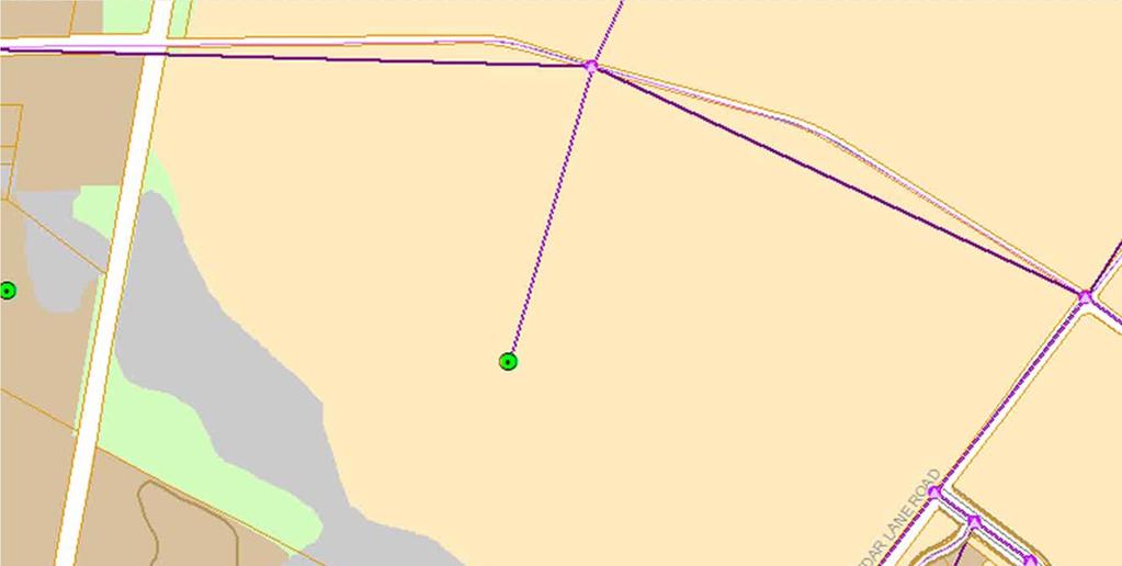
9 9 LUTSAM USER INTERFACE
10 10
11 REGIONAL MODEL FLOW MTDM Demographic Data Processor Peninsula Model TAZ Demographic Data Parcel (Micro TAZ) Database from LUTSAM Define Macro TAZs to be Micromodeled Run Demographic Data Processor Randomly Assigns Household Type to each New Household Re-allocates remaining people, vehicles, and workers to parent TAZ households Refined Trip Generation Refined Trip Distribution Refined Mode Split Refined Traffic Assignment Master Input Network Link and Node Database from LUTSAM Run Network Processor Combines Micro Model and Peninsula Model Links and Nodes into Single Model Network Extract AM/PM peak hour subnetwork and trip tables for microsimulation MTDM Network Processor 11
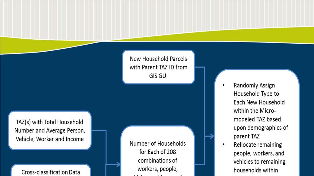
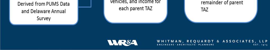
12 HOUSEHOLD SYNTHESIZER
13 LUTSAM - Test Scenario 13 13

14 SCENARIO LOCATIONS 1. Suburban Traditional 2. Urban 14
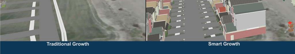
15 SCENARIO DESCRIPTIONS Suburban Traditional 200 single/multi family homes with a big box store Traditional design Four entrances to adjacent roadways Poor connections and pedestrian facilities Urban 200 single/multi family homes with one big box store Compact, dense design Two entrances to adjacent roadways Well connected and completely walkable/bikeable community 15

16 16 SUBURBAN TRADITIONAL

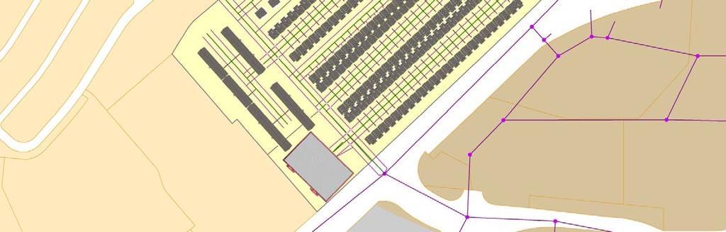
17 17 URBAN GRID
18 WALK/BIKE TRIPS (DAILY) Traditional Urban Walk Bike 18
19 VMT & VMT/TRIP 35, , , ,000 15,000 Traditional Urban 6 Traditional Urban 10, ,000 2 VMT VMT/Trip 19
20 VHT & DELAY Traditional Urban Congested VHT Free VHT Delay 20

21 SMYRNA TRANSPORTATION AND LAND USE STUDY
22 SMYRNA TRANSPORTATION AND LAND USE STUDY Regional Model TAZ = 2,136 Census Block TAZ = 22,500 Tax Parcel TAZ = 7,700


23 SMYRNA TRANSPORTATION AND LAND USE STUDY Sheridan s Pub Christiana Hospital Downtown Smyrna William Henry Middle School Southern Elementary School


24 SMYRNA TRANSPORTATION AND LAND USE STUDY Townhomes Retail Single Family Units Can the Design Form of Potential Development Locations AND Improved Bike & Pedestrian Connections Contribute to Travel Patterns Shifts? US 13 Bike & Pedestrian Improvements
25 SMYRNA TRANSPORTATION AND LAND USE STUDY Results: Significant Increase in Bike/Walk Trips 10% Decrease in Auto Trips to Shopping Pedestrian Trips to Adjacent Shopping Center 10% Less VMT / Unit Vehicle Trips Less Travel on Arterials & Key Intersections 11% Less Emissions / Unit 25

26 26 SMYRNA SAMPLE VIDEO
27 Conclusions Useful for a variety of applications Regional studies Small area studies Corridor studies Transit evaluations Multimodal Studies Allows Standard MPO and Statewide Travel Demand Models to operate at the tax parcel level, taking advantage of the benefits of both regional and parcel based models.


28 Contacts Scott Thompson Graves sthompson Mike DuRoss Rafey Subhani Eric Sundquist Bill Holloway
LINKING LAND FORM AND DEVELOPMENT LOCATION TO MULTIMODAL TRAVEL DEMAND: CASE STUDIES OF TRANSPORTATION AND LAND USE STUDIES IN DELAWARE
 0 0 0 0 LINKING LAND FORM AND DEVELOPMENT LOCATION TO MULTIMODAL TRAVEL DEMAND: CASE STUDIES OF TRANSPORTATION AND LAND USE STUDIES IN DELAWARE CORRESPONDING AUTHOR: Scott Thompson-Graves, P.E., PTOE Whitman,
APPENDIX TRAVEL DEMAND MODELING OVERVIEW MAJOR FEATURES OF THE MODEL
 APPENDIX A TRAVEL DEMAND MODELING OVERVIEW The model set that the Central Transportation Planning Staff (CTPS), the Boston Region Metropolitan Planning Organization s (MPO) technical staff, uses for forecasting
APPENDIX H: TRAVEL DEMAND MODEL VALIDATION AND ANALYSIS
 APPENDIX H: TRAVEL DEMAND MODEL VALIDATION AND ANALYSIS Travel demand models (TDM) simulate current travel conditions and forecast future travel patterns and conditions based on planned system improvements
Des Moines Area MPO. MPO Planning Subcommittee Meeting March 3, Des M oines Area M etropolitan Planning Organization
 Des Moines Area MPO MPO Planning Subcommittee Meeting March 3, 2014 2014 Des M oines Area M etropolitan Planning Organization Agenda 1. Call To Order 2. VOTE: Approval of Agenda 3. VOTE: Approval of Meeting
Porter, D.R., Performance Standards for Growth Management. PAS Report 461. APA Planning Press: Chicago, IL. ed
 Porter, D.R., Performance Standards for Growth Management. PAS Report 461. APA Planning Press: Chicago, IL. ed. 1996. The first five chapters of this report discuss the various performance measures, including
Summary of transportation-related goals and objectives from existing regional plans
 SMTC 2050 Long Range Transportation Plan Appendix A: Summary of transportation-related goals and objectives from existing regional plans SMTC 2050 Long Range Transportation Plan Summary of transportation-related
SCENARIO PLANNING 12
 12 SCENARIO PLANNING Scenario planning represents the next generation of analytical processes created to evaluate the influence of development intensities and land use patterns on the efficiency of a proposed
Database and Travel Demand Model
 Database and Travel Demand Model 7 The CMP legislation requires every CMA, in consultation with the regional transportation planning agency (the Metropolitan Transportation Commission (MTC) in the Bay
Travel Demand Modeling At NCTCOG
 Travel Demand Modeling At NCTCOG Arash Mirzaei North Central Texas Council Of Governments For University of Texas at Arlington ITE Student Chapter March 9, 2005 Agenda Background DFW Regional Model Structure
VEHICLES MILES TRAVELED (VMT) TRAFFIC IMPACT METRIC
 TRAFFIC IMPACT METRIC") VEHICLES MILES TRAVELED (VMT) TRAFFIC IMPACT METRIC A project-specific quantified analysis of the MGA Campus has been undertaken to compare BAU to the project including the project s VMT reduction program
VEHICLES MILES TRAVELED (VMT) TRAFFIC IMPACT METRIC A project-specific quantified analysis of the MGA Campus has been undertaken to compare BAU to the project including the project s VMT reduction program
Metropolitan sustainability and the Interstate System: A new professional paradigm. Eric Sundquist Future of the Interstate Study March 27, 2017
 Metropolitan sustainability and the Interstate System: A new professional paradigm Eric Sundquist Future of the Interstate Study March 27, 2017 Starting point Interstates imagined as inter-city facilities
EXECUTIVE SUMMARY REGIONAL TRANSPORTATION PLAN 2050
 EXECUTIVE SUMMARY REGIONAL TRANSPORTATION PLAN 2050 Introduction Goals Policies, and Performance Measures Growth Forecast and Planned Land Use Development Key Recommendations i Executive Summary April
Urban Transport Modeling (based on these two sources)
") Urban Transport Modeling (based on these two sources) A Transportation Modeling Primer May, 1995 Edward A. Beimborn Center for Urban Transportation Studies University of Wisconsin- Milwaukee http://www.uwm.edu/dept/c
Urban Transport Modeling (based on these two sources) A Transportation Modeling Primer May, 1995 Edward A. Beimborn Center for Urban Transportation Studies University of Wisconsin- Milwaukee http://www.uwm.edu/dept/c
CITY OF JACKSONVILLE 2030 MOBILITY PLAN STUDY UPDATE GOALS, OBJECTIVES, AND PERFORMANCE MEASURES PREPARED FOR: CITY OF JACKSONVILLE
 CITY OF JACKSONVILLE 2030 MOBILITY PLAN STUDY UPDATE GOALS, OBJECTIVES, AND PERFORMANCE MEASURES 3.20.2017 PREPARED FOR: CITY OF JACKSONVILLE 55 Railroad Row White River Junction, VT 05001 802.295.4999
9. TRAVEL FORECAST MODEL DEVELOPMENT
 9. TRAVEL FORECAST MODEL DEVELOPMENT To examine the existing transportation system and accurately predict impacts of future growth, a travel demand model is necessary. A travel demand model is a computer
Transportation Model Report
 1. Introduction The traffic impacts of the future developments in the IL130/High Cross Road corridor for different scenarios were analyzed using a Travel Demand Model (TDM). A four step modeling process
6.0 CONGESTION HOT SPOT PROBLEM AND IMPROVEMENT TRAVEL DEMAND MODEL ANALYSIS
 6.0 CONGESTION HOT SPOT PROBLEM AND IMPROVEMENT TRAVEL DEMAND MODEL ANALYSIS 6.1 MODEL RUN SUMMARY NOTEBOOK The Model Run Summary Notebook (under separate cover) provides documentation of the multiple
Travel Demand Modeling Applications How Modeling is Being Used to Address the Big Issues of Transportation Planning
 How Modeling is Being Used to Address the Big Issues of Transportation Planning Presented by: Dean Munn The Corradino Group Topics This Presentation is organized around two main topics: What is a travel
4: Transportation and Land Use
 Chapter Figure 4-1: Recent development has brought more housing and mixed use Downtown Minneapolis - looking north from E 15th Street at the Grant Street / 11th Street exit 4: Transportation and Land Use
1003 K Street NW, Suite 209 Washington, DC MEMORANDUM. Matthew Ridgway, Nat Bottigheimer, and Alex Rixey, Fehr & Peers
 1003 K Street NW, Suite 209 Washington, DC 20001 202.854.2750 MEMORANDUM Date: To: From: Subject: Eric Graye, M-NCPPC Matthew Ridgway, Nat Bottigheimer, and Alex Rixey, Fehr & Peers Performance Metrics
CHAPTER 2: MODELING METHODOLOGY
 CHAPTER 2: MODELING METHODOLOGY 2.1 PROCESS OVERVIEW The methodology used to forecast future conditions consisted of traditional traffic engineering practices and tools with enhancements to more accurately
Chris Gray (WRCOG), Chris Tzeng (WRCOG), Sarah Dominguez (SCAG), Mike Gainor (SCAG)
, Chris Tzeng (WRCOG), Sarah Dominguez (SCAG), Mike Gainor (SCAG)") TECHNICAL MEMORANDUM Date: 12.17.18 To: Chris Gray (WRCOG), Chris Tzeng (WRCOG), Sarah Dominguez (SCAG), Mike Gainor (SCAG) From: Ronald T. Milam, AICP, PTP and Jason Pack, PE Subject: Review and Assessment
TECHNICAL MEMORANDUM Date: 12.17.18 To: Chris Gray (WRCOG), Chris Tzeng (WRCOG), Sarah Dominguez (SCAG), Mike Gainor (SCAG) From: Ronald T. Milam, AICP, PTP and Jason Pack, PE Subject: Review and Assessment
Appendix O Level of Service Standard and Measurements
 July 8, 2016 Appendix O. Appendix O Standard and Measurements Definition Level of service (LOS) is a mechanism used to determine how well a transportation facility is operating from a traveler s perspective.
Smart Growth Impact Fees
 Smart Growth Impact Fees Presentation to National Impact Fee Roundtable October 10, 2008 Deb Galardi, Galardi Consulting Donald Samdahl, Fehr & Peers Smart Growth and Impact Fees Enhanced ability to fund
Appendix D: Functional Classification Criteria and Characteristics, and MnDOT Access Guidance
 APPENDICES Appendix D: Functional Classification Criteria and Characteristics, and MnDOT Access Guidance D.1 Functional classification identifies the role a highway or street plays in the transportation
New Mexico Statewide Model
 New Mexico Statewide Model Fifth Largest State in land area 2005 Population 1.97 million 42% of state in Albuquerque and Santa Fe area Outside urban areas population density very low New Mexico Planning
Chapter #9 TRAVEL DEMAND MODEL
 Chapter #9 TRAVEL DEMAND MODEL TABLE OF CONTENTS 9.0 Travel Demand Model...9-1 9.1 Introduction...9-1 9.2 Overview...9-1 9.2.1 Study Area...9-1 9.2.2 Travel Demand Modeling Process...9-3 9.3 The Memphis
MOBILITY AND ALTERNATIVES ANALYSIS
 6 MOBILITY AND ALTERNATIVES ANALYSIS BACK OF SECTION DIVIDER 6.0 Mobility and Alternatives Analysis Travel demand analysis provides a framework for the identification of transportation facilities and services
Appendix D Functional Classification Criteria and Characteristics, and MnDOT Access Guidance
 Appendix D Functional Classification Criteria and Characteristics, and MnDOT Access Guidance Functional classification identifies the role a highway or street plays in the transportation system. Some highways
Proposed Comprehensive Update to the State of Rhode Island s Congestion Management Process
 Proposed Comprehensive Update to the State of Rhode Island s Statewide Planning Program January 2018 Summary Outline of of Action Steps 1. Develop Objectives for Congestion Management What is the desired
Moving the first state forward! Delaware s Statewide Long- Range Transportation Plan November 17, 2010 WILMAPCO Our Town
 Moving the first state forward! Delaware s Statewide Long- Range Transportation Plan November 17, 2010 WILMAPCO Our Town Moving the First State t Forward Today s problems yesterday s decisions. Implementation
The Consultant (team) will be required to have knowledge and expertise in the following areas:
 will be required to have knowledge and expertise in the following areas:") SNS Livable Centers Study - Consultant Scope Elements - DRAFT PROJECT DESCRIPTION OBJECTIVE The overall goal of the Livable Centers Study is to foster multimodal access and connectivity, a mix of uses,
SNS Livable Centers Study - Consultant Scope Elements - DRAFT PROJECT DESCRIPTION OBJECTIVE The overall goal of the Livable Centers Study is to foster multimodal access and connectivity, a mix of uses,
Lesson 2. Principles of. Transportation. Land Use 2-1
 Lesson 2 Principles of Transportation & Land Use 2-1 Learning Outcomes Explain transportation s impact on land use and development patterns, including historical growth patterns Explain how land use patterns
Long Range Transportation Plan Project Status Update
 HEPMPO Webinar Meeting Long Range Transportation Plan Project Status Update Michael Baker Jr., Inc. Foursquare Integrated Transportation Planning December 4, 2013 1 Meeting Agenda 1. Project Overview 2.
Land Use Assumptions and the Plan Development Process
 Land Use Assumptions and the Plan Development Process Regional Transportation Plan 2030 115 Regional Transportation Plan 2030 116 Land Use Assumptions and the Plan Development Process Travel demand is
Overcoming Barriers to Mixed-Use Infill Development: Let s Get Trip Generation Right
 Overcoming Barriers to Mixed-Use Infill Development: Let s Get Trip Generation Right By: Matt Goyne, Mackenzie Watten, and Dennis Lee with Fehr & Peers Please contact Matt Goyne at m.goyne@fehrandpeers.com
Utilizing GIS to Assess Win-Win Built Environment Investments: Transportation Modeling Methodologies and Economic Analysis Applications
 Utilizing GIS to Assess Win-Win Built Environment Investments: Transportation Modeling Methodologies and Economic Analysis Applications GIS-T Symposium, April 2009 Sasanka Gandavarapu Wilbur Smith Associates
Project Summary. Project Objectives
 M2D2 Multi Modal Development and Delivery A project to support Michigan s economic recovery by improving MDOT s institutional capacity to plan, design, construct, operate and maintain Michigan s transportation
Transportation and Utilities
 4 Section 4 Transportation and Utilities 4.0 Introduction Transportation and utility systems are essential to accommodate and support development proposed in the Future Land Use Map. The following pages
Land Use and Traffic Congestion
 LandUse andtrafficcongestion FinalReport618 March2012 Preparedby: J.RichardKuzmyak TransportationConsultant,LLC SilverSpring,Maryland InAssociationwith: CaliperCorporation Newton,Massachusetts and PolyTechCorporation
Performance Measures for Transportation Planning Part 1
 Performance Measures for Transportation Planning Part 1 Flint, MI July 12, 2011 Brian Betlyon FHWA Resource Center Overview Performance Measurement in Transportation Planning Module Outcomes Describe performance
Regional Evaluation Decision tool for Smart Growth
 Regional Evaluation Decision tool for Smart Growth Maren Outwater, Robert Cervero, Jerry Walters, Colin Smith, Christopher Gray, Rich Kuzmyak Objectives This project is one of the SHRP 2 Capacity projects
2016 Subdivision Staging Policy TISTWG 6/7/16. Draft Review of Worksession #1 on 6/9/16
 206 Subdivision Staging Policy TISTWG 6/7/6 Draft Review of Worksession # on 6/9/6 Reflect: current land use patterns, travel modes, and planning vision. Organize the County Policy Areas into four (4)
Appendix E Technical Description of the Modeling Framework
 Appendix E Technical Description of the Modeling Framework Appendix E Technical Description of Modeling Framework Appendix E Technical Description of Modeling Framework 1 In general terms, what analysis
CHAPTER 7. TRAVEL PATTERNS AND TRAVEL FORECASTING
 CHAPTER 7. TRAVEL PATTERNS AND TRAVEL FORECASTING TRAVEL PATTERNS Northwest Arkansas has experienced unprecedented growth in population and employment in the past 25 years. The economic vitality and diversity
Maryland Statewide Transportation Model (MSTM)
") Maryland State Highway Administration (MD SHA) Maryland Statewide Transportation Model (MSTM) TRB Meeting Federal Surface Transportation Requirements in Statewide and Metropolitan Transportation Planning:
Maryland State Highway Administration (MD SHA) Maryland Statewide Transportation Model (MSTM) TRB Meeting Federal Surface Transportation Requirements in Statewide and Metropolitan Transportation Planning:
Subdivision Staging Transportation Recommendations. Subdivision Staging Policy Community Meeting II April 12, 2016
 Subdivision Staging Transportation Recommendations Subdivision Staging Policy Community Meeting II April 12, 2016 DISCUSSION TOPICS Re-cap of 3/15 Public Meeting Background and context Recommended approach
- FACT SHEET - THE GUIDING PRINCIPLES
 THE GUIDING PRINCIPLES The General Plan begins with seven ideas that together create a vision for the City s future. When the City approved the General Plan in 1994, these idea were dubbed the Seven Guiding
Buffalo Niagara Integrated Corridor Management Project. ENTERPRISE Webinar Keir Opie, Cambridge Systematics September 26, 2016
 Buffalo Niagara Integrated Corridor Management Project ENTERPRISE Webinar Keir Opie, Cambridge Systematics September 26, 2016 1 Buffalo-Niagara ICM Corridors I-190 ICM Corridor Cross Border Corridor 2
Transportation and Smart Growth ITE Traffic Engineering Workshop, March, 2004 Edward Beimborn, UWM
 Transportation and Smart Growth ITE Traffic Engineering Workshop, March, 2004 Edward Beimborn, UWM 1 Acknowledgements CE 790, Transportation Systems Design, Fall, 2003. Theme: Transportation 2050 Joe Blakeman,,
Table II.B.3.1: Regional Trends, Concord-Kannapolis UA. Year Pct Ch Pct Ch
 3. Concord-Kannapolis-Rowan A. Regional trends The Concord-Kannapolis region, situated about 20 miles northeast of the greater Charlotte region, was until the 1970 s a largely independent region with a
Contents i Contents Page 1 A New Transportation Plan Community Involvement Goals and Objectives... 11
 Contents i Contents 1 A New Transportation Plan... 1 Why develop a new plan?... 1 What area does the LRTP focus on?... 2 Why is this LRTP important?... 3 Meeting Requirements for Transportation Planning...
Transportation Concurrency
 2015 Frequently Asked Questions About. Transportation Concurrency Q. What is Transportation Concurrency? A. Transportation Concurrency is both a State law requirement and a City pre-application development
Transportation Concurrency
 2017 Frequently Asked Questions About. Transportation Concurrency Q. What is Transportation Concurrency? A. Transportation Concurrency is both a State law requirement and a City pre-application development
Performance Based Transportation Project Assessment. Utilizing Travel Demand Model Data and Dynamic Economic Modeling
 Performance Based Transportation Project Assessment Utilizing Travel Demand Model Data and Dynamic Economic Modeling Colin Belle, Metropolitan Planner Region 1 Planning Council (R1PC), Rockford Illinois
Chapter 4: Transportation and Land Use
 Chapter 4: Transportation and Land Use Transportation and land use together make possible the wide range of destination opportunities in the region. Transportation provides the connections, and, in turn,
Standardization of Travel Demand Models
 Standardization of Travel Demand Models TNMUG Meeting November 14, 2013 The North Carolina Experience Leta F. Huntsinger, Ph.D., P.E. and Rhett Fussell, P.E. Background } North Carolina Profile } 18 MPOs,
USING TRAFFIC IMPACT FEES TO FUND ALTERNATIVE TRANSPORTATION PROJECTS AND IMPACT MODAL CHOICE IN URBAN AREAS. Mark J. Magalotti P.E.
 USING TRAFFIC IMPACT FEES TO FUND ALTERNATIVE TRANSPORTATION PROJECTS AND IMPACT MODAL CHOICE IN URBAN AREAS by Mark J. Magalotti P.E. BS, University of Pittsburgh, 1976 MS, University of Pittsburgh, 1981
Recommended Roadway Plan Section 3 Existing Facilities & System Performance
 Recommended Roadway Plan Section 3 Existing Facilities & System Performance RECOMMENDED ROADWAY PLAN SECTION 3 Existing Facilities and System Performance 3.1 Introduction An important prerequisite to transportation
Greenhouse Gas Emission Reduction Strategies
 Greenhouse Gas Emission Reduction Strategies 2011 ITE Quad Conference April 18 19, 2011, Embassy Suites; Lynnwood, WA Victor L. Sl Salemann, PE Senior Associate David Evans and Associates Bellevue, WA
Congestion Management Process 2013 Update
 OVERVIEW OF THE DALLAS-FORT WORTH CONGESTION MANAGEMENT PROCESS Traffic Congestion In The Dallas-Fort Worth Region With the Dallas-Fort Worth (DFW) urban area as its center, the North Central Texas region
Sustainable Transportation Performance Measures
 Sustainable Transportation Performance Measures Christopher Forinash EPA Office of Sustainable Communities Conference on Performance Measures for Transportation and Livable Communities Austin, Texas 7
To Market, To Market. Discussion Contents. Part 1: Land Use & Infrastructure
 To Market, To Market Discussion Contents Part 1: Land Use & Infrastructure Internal Capture & Pass By Traffic Urban Calculations Rural Realities Case Study 1: Rural Pass-By Community Capture Case Study
INTEGRATED MOBILITY PLAN
 Re: Item No. 3 INTEGRATED MOBILITY PLAN Committee of the Whole December 5, 2017 halifax.ca/integratedmobility Presentation Outline Why the IMP Now? Big Transportation Moves in HRM IMP Vision and Transportation
Appendix C: Scenarios and Future Drivers Impacting Transportation
 Prepared for Washington County Prepared by David Evans and Associates, Inc. 2100 SW River Parkway Portland, Oregon 97201 TABLE OF CONTENTS 1. INTRODUCTION... 2 2. SCENARIOS PLANNING OVERVIEW... 2 3. SCENARIOS
2040 Addendum Performance-Based Planning November 2018
 2040 Long Range Transportation Plan 2040 Addendum Performance-Based Planning November 2018 Adopted June 13, 2018 250 S. Orange Ave, Suite 200, Orlando, FL 32801 407-481-5672 www.metroplanorlando.org MetroPlan
Regional Transit Framework Study
 MARICOPA ASSOCIATION OF GOVERNMENTS Regional Transit Framework Study Regional Stakeholders Group Meeting #1 February 29, 2008 Copyright 2008 AGENDA Welcome and Introductions Project Process Regional Transit
Context. Case Study: Albany, New York. Overview
 Case Study: Albany, New York Overview The Capital District, a four-county region surrounding Albany, New York, has experienced dramatic growth in vehicle-miles of travel (VMT) in recent years, which has
Market-to-Market Market influences on Transportation and Development. Dawn Cartier & Tom Hester January 2015
 Market-to-Market Market influences on Transportation and Development Dawn Cartier & Tom Hester January 2015 To Market, To Market Discussion Contents Part 1: Land Use & Infrastructure Internal Capture &
State of the Practice - How Public Transportation is addressed in Traffic Impact Studies ITE Transit and Traffic Impact Studies Committee
 State of the Practice - How Public Transportation is addressed in Traffic Impact Studies ITE Transit and Traffic Impact Studies Committee Purpose of Report Relevant Literature Survey Results Current and
Executive Summary. Reimagining a Legacy Transit System: Lessons from Wilmington, Delaware
 Executive Summary Executive Summary Delaware Transit Corporation (DTC) is a wholly owned subsidiary of the Delaware Department of Transportation. DTC operates fixed-route bus, paratransit, commuter rail,
City of Tacoma TRANSPORTATION MASTER PLAN DRAFT
 City of Tacoma TRANSPORTATION MASTER PLAN 140 APPENDICES Appendix A Model Documentation MEMORANDUM Date: November 26, 2014 To: City of Tacoma, Department of Public Works From: Chris Breiland, Fehr & Peers
Kentucky Statewide Travel Model (KYSTM) Rob Bostrom Wilbur Smith Associates Combined Kentucky-Tennessee Model Users Group Meeting Bowling Green, KY
 Rob Bostrom Wilbur Smith Associates Combined Kentucky-Tennessee Model Users Group Meeting Bowling Green, KY") Kentucky Statewide Travel Model (KYSTM) Rob Bostrom Wilbur Smith Associates Combined Kentucky-Tennessee Model Users Group Meeting Bowling Green, KY October 26, 2006 Presentation Overview Overview of statewide
Kentucky Statewide Travel Model (KYSTM) Rob Bostrom Wilbur Smith Associates Combined Kentucky-Tennessee Model Users Group Meeting Bowling Green, KY October 26, 2006 Presentation Overview Overview of statewide
MTP VISIONS, GOALS, AND OBJECTIVES
 2 MTP VISIONS, GOALS, AND OBJECTIVES El Paso MPO 2045 Metropolitan Transportation Plan 2. GUIDING PRINCIPLES This chapter describes the process by which the vision and goals of the planning process were
Congestion Management Strategy
 Congestion Management Strategy Vancouver as of 2018 50% of trips are made on foot, by bike or transit. 6 major bridges in Vancouver. 32% decrease in distance driven per person since 2007. 4.6% population
SHIFT Model Training: Scenario 3A
 SHIFT Model Training: Scenario 3A ITTS Freight in the Southeast Conference 2017 Liza Amar February 15 th 2017 Overview SHIFT Model Scope Model Scenario Examples Coding the Scenario Running the Model Evaluating
Chapter 2 Transportation Element Goals, Objectives and Policies
 Chapter 2 Transportation Element Goals, Objectives and Policies City of Belleview Comprehensive Plan Adopted by Ord 2016-10 on July 5, 2016 GOALS, OBJECTIVES AND POLICIES Goal 2 Transportation...1 Objective
Memorandum. FROM: Jim Ortbal Rosalynn Hughey Barry Ng TO: HONORABLE MAYOR, CITY COUNCIL. DATE: June 16, 2017
 CITY OF SANjOSE CAPITAL OF SILICON VALLEY TO: HONORABLE MAYOR, CITY COUNCIL SUBJECT: TRANSPORTATION POLICY UPDATE REQUIRED BY STATE LAW - LOS TO VMT Memorandum FROM: Jim Ortbal Rosalynn Hughey Barry Ng
Performance Measures Workshop, May 18, 2017
 Measuring What Matters: Above and Beyond Requirements Performance Measures Workshop, May 18, 2017 Presentation Overview Background - origin and evolution of the Regional Outcomes Framework. Regional Outcomes
GUIDE FOR THE PREPARATION OF TRAFFIC IMPACT STUDIES
 GUIDE FOR THE PREPARATION OF TRAFFIC IMPACT STUDIES Adopted by Town Council on November 25, 2008 Prepared By: HNTB Engineering Department Planning Department TABLE OF CONTENTS I. INTRODUCTION... 1 II.
Scope of Work. Land Use, Transportation, and Resilience: Scenario Planning Study East Tangipahoa Area State Project No. H RPC Task: ETangi
 Scope of Work Land Use, Transportation, and Resilience: Scenario Planning Study East Tangipahoa Area State Project No. H.013576 RPC Task: ETangi Project Description The Regional Planning Commission is
THAT Council adopt the Congestion Management Strategy as outlined in this report
 RR3 ADMINISTRATIVE REPORT Report Date: May 2, 2017 Contact: Winston Chou Contact No.: 604.873.7913 RTS No.: 011564 VanRIMS No.: 08200020 Meeting Date: May 16, 2017 TO: FROM: SUBJECT: Vancouver City Council
TRAFFIC ANALYSES TO SUPPORT NEPA STUDIES
 VIRGINIA DEPARTMENT OF TRANSPORTATION ENVIRONMENTAL DIVISION NEPA PROGRAM LOCATION STUDIES TRAFFIC ANALYSES TO SUPPORT NEPA STUDIES CONSULTANT RESOURCE GUIDANCE DOCUMENT Issued on: November 18, 2016 Last
REGIONAL PLANNING AND POLICY FRAMEWORK A Preferred Approach for our Regional Growth
 REGIONAL PLANNING AND POLICY FRAMEWORK A Preferred Approach for our Regional Growth The Regional Comprehensive Plan (RCP) establishes a new approach to planning in the San Diego region. This approach is
Nashville Southeast Corridor High-Performance Transit Alternatives Study. Final Report
 Nashville Southeast Corridor High-Performance Transit Alternatives Study Final Report August 2007 - Nashville Southeast Corridor Executive Summary I. Introduction The southeast corridor is a 30 mile long
CALIFORNIA URBAN INFILL TRIP GENERATION STUDY. Luke Schwartz Kimley-Horn and Associates
 CALIFORNIA URBAN INFILL TRIP GENERATION STUDY Luke Schwartz Kimley-Horn and Associates Overview What is the CA Urban Infill Trip Generation Study Why was this study undertaken? Research methodology Trip
A Shift from LOS to VMT in the California Environmental Quality Act
 A Shift from LOS to VMT in the California Environmental Quality Act General Goal: Protect natural resources and improve quality of life by directing new growth to existing cities and suburbs October 2014
Improved Software Tools for Regional & Local Integrated Land Use/Transportation Planning in California (funded by Caltrans)
") Improved Software Tools for Regional & Local Integrated Land Use/Transportation Planning in California (funded by Caltrans) Training Session Tuesday June 26, 2012 10:00 to 12 noon AGENDA Opening: Introductions
Improved Software Tools for Regional & Local Integrated Land Use/Transportation Planning in California (funded by Caltrans) Training Session Tuesday June 26, 2012 10:00 to 12 noon AGENDA Opening: Introductions
CHAPTER 2. VISION, GOALS AND MTP FRAMEWORK
 CHAPTER 2. VISION, GOALS AND MTP FRAMEWORK MTP VISION In order to create a framework for the 2040 Metropolitan Transportation Plan (MTP), a vision statement was drafted by the Vision/Goals Committee and
TRANSPORTATION AND LAND USE
 TRANSPORTATION AND LAND USE INTRODUCTION The 2020 and 2030 GHG projections estimate that transportation emissions in the unincorporated area will increase considerably in the next two decades. Minimizing
Multi-Resolution Traffic Modeling for Transform 66 Inside the Beltway Projects. Prepared by George Lu, Shankar Natarajan
 Multi-Resolution Traffic Modeling for Transform 66 Inside the Beltway Projects Prepared by George Lu, Shankar Natarajan 2017 VASITE Annual Meeting, June 29, 2017 Outline Transform I-66 Inside the Beltway
TRANSPORTATION IMPACT STUDIES
 January 28, 2009 POLICIES AND PROCEDURES FOR TRANSPORTATION IMPACT STUDIES Related to Highway Occupancy Permits Pennsylvania Department of Transportation Bureau of Highway Safety and Traffic Engineering
INDIANA S INTERMODAL MANAGEMENT SYSTEM Stephen C. Smith Planning Manager, Transportation Planning Division Indiana Department of Transportation
 96 INDIANA S INTERMODAL MANAGEMENT SYSTEM Stephen C. Smith Planning Manager, Transportation Planning Division Indiana Department of Transportation Indiana is in the process of developing an Intermodal
Section 1.0 INTRODUCTION. Section 2.0 MODEL ARCHITECTURE RECOMMENDATIONS, PHASE I, TIER I - PASSENGER CAR AND TRUCK..
 TABLE OF CONTENTS Section 1.0 INTRODUCTION Section 2.0 MODEL ARCHITECTURE RECOMMENDATIONS, PHASE I, TIER I - PASSENGER CAR AND TRUCK.. Section 2.1 General Software and Forecast Year Recommendations. Section
TRANSPORTATION DEMAND FORECASTING INFORMATION SESSION
 GTA WEST CORRIDOR PLANNING AND EA STUDY-STAGE STAGE 1 TRANSPORTATION DEMAND FORECASTING INFORMATION SESSION JUNE 2008 Topics for this Session 1. The Challenge of Growth 2. Overview of GTAW Study 3. The
MULTIMODAL TRANSPORTATION IMPACT STUDY GUIDELINES
 MULTIMODAL TRANSPORTATION IMPACT STUDY GUIDELINES 1 st Edition City of San Luis Obispo 2035 Circulation Element 1 Table of Contents Introduction... 2 Process... 2 When Impact Studies Are Required... 3
6.1 Integrated Land Use and Transportation Planning Approach
 6. ANALYSIS OF ALTERNATIVES 6.1 Integrated Land Use and Transportation Planning Approach In 2003, the initiated the Growth Related Integrated Development Strategy study, known as GRIDS. The GRIDS Study
Measuring Success: Using data wisely for a healthier, wealthier, more equitable city. NACTO Conference, October 2013.
 Measuring Success: Using data wisely for a healthier, wealthier, more equitable city NACTO Conference, October 2013 Jeffrey Tumlin Commonly Used Performance Measures Source: Reid Ewing Old Speed Paradigm
Final Regional 2035 Transportation Plan Adopted: January 21, 2010
 Final Regional 2035 Transportation Plan Adopted: January 21, 2010 Paul T. Hamilton, Chief Planner Tri-County Regional Planning Commission Federal Requirement Safe Accountable Fair and Efficient Transportation