4. IDENTIFICATION OF SPECIFIC TRANSPORTATION PROBLEMS WITHIN THE STUDY AREA
|
|
|
- Easter Warren
- 5 years ago
- Views:
Transcription
1 4. IDENTIFICATION OF SPECIFIC TRANSPORTATION PROBLEMS WITHIN THE STUDY AREA 4.1 Introduction The primary function of the inter-regional transportation system is to facilitate the movement of people and goods within and through the Study Area by all modes. At a baseline level, the road network connects all modes of the transportation system for moving people and goods by private automobiles, commercial vehicles, transit, air, marine and rail services. From earlier sections of this report, it is understood that the transportation system and the movement of people and goods are influenced by policy, land use, economy and tourism and recreation. Forecasts for the GTA West Study Area show substantial growth to 2031: population and employment are expected to more than double between 2001 and 2031, including growth of more than 1 million people and more than 450,000 jobs. Accordingly, Study Area travel is expected to increase significantly: PM peak period person trips are forecast to increase by over 170% between 2001 and 2031 (by approximately 700,000 trips), based on Greater Golden Horseshoe (GGH) Model outputs. In addition to the increase in commuting trips, the GGH s growth in population and employment will result in increased tourism and recreation trips to/from and through the GTA West Corridor. The projected growth will also result in increased goods movement throughout the GGH. Trucks will continue to be the dominant mode for shipping in the Study Area. The overarching problem of the inter-regional transportation system in 2031 relates to the road network. Much of the higher order road system (i.e., highways and inter-regional roads) is expected be heavily congested during peak periods and increasingly throughout the day. Road congestion in summer is higher due to the overlay of tourism and recreation travel. The fact that every mode connects to and relies on the road network creates significant issues for the efficient movement of people and goods in the future. Transportation in the GTA West Study Area in 2031 can be considered in the context of two sub-areas with differing geographic, land use and transportation system characteristics: East Study Area Milton to Vaughan The Study Area's highways (Highways 401, 400, 410, 427 and 407 ETR) are concentrated in the east and south of the GTA West Corridor. While a number of interregional road connections are in place, all highways in the Study Area (with the exception of some sections of the 407 ETR) will continue to experience major congestion throughout the day, particularly as population and employment growth intensifies to the west and north of existing built up areas. Highway 401 provides the major east-west connection across the Study Area s southern boundary and continues to be heavily congested. Inter-regional rail transit service will be provided by GO Transit and will include rail expansion/improvements to Brampton, Bolton and Milton. The Metrolinx RTP identifies July 2009 DRAFT Page 101
2 Bus Rapid Transit service along the 407 ETR and Other Rapid Transit into the southeast portion of the Study Area. Major congestion along the area highways constrains commuter travel and trucking transport, and is a major concern for economic growth and prosperity. West Study Area Milton to Guelph There are few highway and transit connections to the west and north of the Study Area. Highway 7 provides a lower capacity east-west connection to Guelph, and is expected to operate with minor congestion by Highway 6 runs north-south along the Study Area's western boundary, and is expected to operate with major congestion south of Guelph. Higher order inter-regional GO Transit service is being examined to extend to Guelph/Kitchener but there are limited planned inter-regional transit services between communities north and west of Toronto. There are opportunities in this portion of the GTA West Corridor for improved roadway and transit connections to Toronto and to areas farther west and south toward Hamilton, Niagara and the U.S. border in the Niagara to GTA Corridor. 4.2 Moving People The movement of people in the GTA West Study Area is predominantly comprised of trips for commuting and for tourism and recreation. Although these types of travel have different characteristics and service requirements, many of the future transportation problems are similar. In general, the limited choice of alternate travel modes in the Study Area increases reliance on the automobile. In order to better identify transportation problems and opportunities, the Study Team adopted a two-pronged approach. Firstly, a range of background reports and secondary sources was reviewed to understand the views of others studying this area and the transportation problems and opportunities identified. These include area municipalities Official Plans, Transportation and Transit Master Plans, and Metrolinx reports. Subsequently, the Study Team initiated a thorough consultation with Business and Commercial Stakeholders (BCS) and Transportation Service Providers (TSP), through face-to-face interviews, phone interviews and mail-back questionnaires. These stakeholders represent a range of large corporations, business associations, logistics specialists as well as rail, marine and transit operators. In general, these stakeholders confirmed that a number of transportation problems do currently exist and are likely to continue through the foreseeable future. Further details of stakeholder consultation are provided in Appendix A Commuter Transit The Study Area s planned increase in population and employment, as per the Growth Plan, alongside the significant transit improvements contained in the Metrolinx RTP and GO Transit s Strategic Plan, are expected to result in a substantial number of additional transit trips in While the automobile is expected to remain the dominant mode of travel, PM peak period transit trips in the GTA West Corridor are forecast to increase by more than 540%, increasing the PM peak period transit mode share from 4% of total trips in 2001 to 9% in July 2009 DRAFT Page 102
3 Inter-regional transit services are generally focused on connecting urban centres and major gateways that are integrated with local transit service or integrated with park-andride facilities. A number of bus and rail services operate throughout the GTA West Study Area, including GO Rail, VIA Rail, GO Bus, Greyhound Bus and Coach Canada Bus. The inter-regional buses generally follow the main Study Area highways discussed in Section 4.2.2, and rail services generally operate radially into Toronto s Central Business District (CBD). Exhibit 4-1 shows the existing regional rapid transit and highway network, including peak and full-day rail services, subways, and bus and light rail rapid transit. Inter-regional transit services within the context of the Study Area are shown in Exhibit 4-2, including inter-regional bus services. The following constraints have been identified relating to the GTA West Study Area transit system: there is limited community-to-community inter-regional transit, with some services such as VIA Rail passing through without serving any communities within the Study Area; municipal transit operators may not provide for convenient transfers between different services; and there is no overarching mechanism to make inter-regional travel seamless. Increased roadway congestion limits the efficiency of bus transit services, and increases travel times and unpredictability. A substantial effort is being made toward improvements in transit in the GTHA. Initiatives such as MoveOntario 2020, GO Transit s Strategic Plan and Metrolinx s RTP will increase transit provisions and improve existing services. Both GO Transit and Metrolinx are committed to work actively with public and private sector transportation providers to provide co-ordinated, convenient, integrated transit services in the GO Transit service area. The provincial gas tax program supports such transit improvements through its provision of funding to municipalities for expansion and improvement of transit services. Since 2004, the province has committed over $1.3 billion in gas tax funding to Ontario municipalities, including more than $183 million to transit systems in the Regions of York, Peel and Halton, County of Wellington, and City of Guelph. The 2008/2009 program year includes up to $321 million for transit systems across the province. The Metrolinx 25-year plan for the regional rapid transit and highway network is presented in Exhibit 4-3; it includes plans to more than double the length of rapid transit service within the region, provide increased transit capacity and introduce new bus and rail services. Although these initiatives will improve the transit system, issues such as limits of transit frequency and service areas outside of urban centres, and impacts of road congestion on bus services will still affect its efficiency and ability in providing interregional transportation services to commuters. The inter-regional transit market could also be potentially limited due to the Growth Plan objective toward more self-contained urban centres. July 2009 DRAFT Page 103
4 Exhibit 4-1: Existing Regional Rapid Transit and Highway Network (Metrolinx) July 2009 DRAFT Page 104
5 Exhibit 4-2: Existing Inter-Regional Transit Services July 2009 DRAFT Page 105
6 Exhibit 4-3: 25-Year Plan for the Regional Rapid Transit and Highway Network (Metrolinx) July 2009 DRAFT Page 106
7 As discussed in Section and Section 2.6.5, there are a number of GO Transit plans in various stages of planning and development and with varying degrees of committed funding. The initiatives within the GTA West Study Area include the following: GO Rail expansion to Guelph/Kitchener GO Transit service extension from Milton to Cambridge GO Transit service extension from Hamilton to Brantford GO Rail expansion to Bolton GO Rail frequent all day service between Mount Pleasant, Brampton and Union Station GO Rail frequent all day service between Meadowvale and Union Station Brampton Acceleride (enhanced bus rapid transit along five arterial corridors) Main Street/Hurontario Rapid Transit GO Transit BRT linking Oakville, Square One in Mississauga, and Vaughan City Centre GO Bus to Kitchener-Waterloo As discussed, the automobile is currently the predominant mode for commuting travel in the GTA West corridor. It is intended that future transit improvement initiatives will increase the competitiveness of transit compared to the automobile and thereby increase transit s mode share for commuter travel. Exhibit 4-4 presents the 2031 PM peak period person trips and transit mode shares anticipated to the Study Area s Urban Growth Centres (Guelph, Milton, Brampton and Vaughan). PM peak transit mode shares from Downtown Toronto to these Urban Growth Centres are expected to be significant, upwards of 50%. Outside of Toronto (Downtown and other areas), there is greater variability in PM peak period inter-regional transit mode shares. Transit mode shares for trips to Guelph range from 0% from Milton and Cambridge to 7% from Brampton. Trips to Milton range from 0% transit use from Guelph and Cambridge to 14% from Markham. To Brampton, transit mode shares are as low as 0% from Cambridge and as high as 12% from Vaughan and Oakville and 15% from Mississauga. Finally, PM peak period transit mode shares to Vaughan are 1% from Cambridge and up to 16% and 23% from Mississauga and Oakville, respectively. Generally speaking, experience in Ontario suggests that the interregional transit mode share between communities at the fringe of urban areas will range between 5% and 15%. July 2009 DRAFT Page 107
8 Exhibit 4-4: 2031 PM Peak Period Total Person Trips and Transit Mode Share Transit travel times between many Urban Growth Centres should decrease between now and 2031 with the implementation of the 25-year RTP. PM peak period transit travel times from the GTA West corridor s four Urban Growth Centres were assessed for 2001 and As shown in Exhibit 4-5, transit travel times from these Urban Growth Centres are expected to decrease considerably. These model results are a reflection of the significant growth in automobile travel on an increasingly congested road network, and the planned transportation measures throughout the GGH. The anticipated decrease in transit times assumes the significant infrastructure and service improvements for transit that are included in the RTP. Presently, these linkages and high frequencies are not in place and the measures that will be required to improve transit services and therefore increase transit mode shares are substantial. The province has charged Metrolinx with the responsibility of moving forward with the implementation of the RTP, in consultation with all municipalities in the GTHA. July 2009 DRAFT Page 108


9 Exhibit 4-5: Change in PM Peak Period Transit Travel Times to 2031 between Urban Growth Centres From Vaughan Corporate Centre From Downtown Brampton From Downtown Milton From Downtown Guelph July 2009 DRAFT Page 109
10 Analysis conducted for the current study, supported by background reports and findings from stakeholder consultation, identifies future problems on the inter-regional commuter transit network. There are four main future problems associated with commuting by the inter-regional transit system: Limited integration between local and inter-regional transit, particularly beyond corridors served by GO Transit, reduces transit s attractiveness to commuters and its competitiveness compared to the automobile Limited community to community transit service can result in extra transfers between services, decreasing convenience and increasing travel times Passenger rail services can conflict with freight for use of rail capacity Buses are impacted by road congestion, increasing unreliability and travel times The lack of integration results from: Limited connections between local transit and inter-regional transit Incompatible fare structure and payment systems Differing timetables and hours of operation Inadequate waiting/transfer areas and amenities Transit services are generally radially oriented, providing connections to Toronto Even with the planned connections, transit between UGCs such as Milton-Brampton and Milton-Guelph is more limited and indirect, requiring transfers and circuitous routes 2031 PM transit mode shares indicate the low usage expected for inter-regional trips between UGCs: Guelph-Milton 0% Guelph-Brampton 7% Guelph-Vaughan 2-4% Milton-Brampton 2-3% Milton-Vaughan 4-7% Brampton-Vaughan 11-12% Expansion of passenger and freight rail services within existing rail corridors creates potential for conflicts, particularly during peak commuting periods, as well as issues of scheduling and integration of rail services Issues of congestion, increasing travel time, and unreliability due to non-recurring incidents limit the efficiency and attractiveness of bus services operating in mixed traffic Commuter Automobile The substantial growth in population and employment in the Study Area, as per the Growth Plan, is expected to result in an increase in PM peak period automobile trips of July 2009 DRAFT Page 110
11 approximately 140% between 2001 and While the automobile is expected to remain the transportation mode of choice in the GTA West Corridor, its PM peak period mode share is anticipated to decrease from approximately 79% in 2001 to 70% in 2031, largely due to the substantial transit improvements planned for the Greater Golden Horseshoe (GGH). Mode choice for commuter travel depends on a number of factors, including trip purpose, origins and destinations of trips and available network connections, as discussed in Section 2.1. The origin-destination analysis reveals significant numbers of trips made internally within the Study Area s upper tier municipalities. Approximately 77% of trips in Wellington, 71% in Peel and 70% in Halton are expected to remain within each respective region during the weekday PM peak hour. This represents a slight reduction from 2006 levels (83% in Wellington, 77% in Peel and 73% in Halton). Trips across municipal boundaries are expected to be more substantial between Peel and Toronto/York/Durham Regions, with the numbers of cross-boundary trips decreasing toward the west. The road transportation system is the main mode used for commuting in the Study Area, especially where trips are not served by a higher order transit alternative. Although transit mode shares are expected to remain low, transit does play an important role in commuter travel, where connections are available. Travel for commuting generally occurs in the AM and PM peak periods and this has an impact on the overall operation of the transportation network. As traffic volumes increase throughout the day, the traditional AM and PM peak periods are becoming longer, resulting in major roadways, such as Highway 401, being congested throughout much of the day. Significant growth is expected in commuter travel demand through to 2031, resulting in significant capacity deficiencies on the road and transit networks. Highway 401 is the main highway corridor through the Study Area, with Highways 400, 427 and 410 providing key highway links for automobile commuters. There are a number of heavily congested links on the major highways. Exhibit 4-6 illustrates PM peak hour congestion in Significant congestion is experienced along much of Highway 401 in the GTA West Study Area, as well as on Highways 400, 427 and 410. All of these major routes experience Levels of Service of E or F, indicating that the volume/capacity ratio is over 0.9 and Congested, Stop-and-Go conditions are experienced, as described in the table below. Traffic volumes are increasing throughout the day such that congestion is spreading beyond the traditional AM and PM peak periods. Congestion Type Approximate V/C Description Minor Less than 0.80 Non-recurring Congestion* Moderate 0.80 to 0.90 Unstable Conditions Major 0.90 and above Congested Conditions (Stop-and-Go) * Traffic conditions may be adversely affected by incidents, accidents, weather, and construction / maintenance activities July 2009 DRAFT Page 111


12 Exhibit 4-6: 2006 Weekday (AADT) Highway Congestion The highways within the Study Area currently operate with considerable peak hour congestion, with the following major automobile commuter transportation system constraints: Highway 401 along its entire length in the Study Area, with the most severe constraints in the Region of Peel and City of Toronto Highway 400 south of Major Mackenzie Drive, north of the 407 Electronic Toll Route (ETR) Highway 427 between Highway 401 and Highway 7 Highway 410 north of the 407 ETR Summer average daily traffic (SADT) is generally greater than the AADT that occurs throughout the year. SADT is characterized by longer peak periods and more balanced traffic volumes by direction as commuter and tourism and recreation trips overlap. As discussed in Section 4.2.4, tourism and recreation traffic contributes to summer roadway July 2009 DRAFT Page 112

 Highway Congestion Exhibit 4-8 illustrates the substantial growth forecast for westbound PM peak period travel by automobile, at specific GTA West")

13 congestion, with trips to, from and through the Study Area. As shown in Exhibit 4-7, 2006 SADT conditions are more congested than AADT conditions, with additional congestion on Highway 400 south to Highway 401, and on the 407 ETR between Highways 400 and 410. Exhibit 4-7: 2006 Weekend (SADT) Highway Congestion Exhibit 4-8 illustrates the substantial growth forecast for westbound PM peak period travel by automobile, at specific GTA West screenlines (a boundary that defines a broad corridor across which traffic flows). In the eastern part of the Corridor, west of Highway 427, westbound PM peak hour flows are expected to increase by as much as 25%. Traffic volumes farther west, east of Winston Churchill Boulevard, are to increase significantly, by 80% to 95%. In the western-most part of the GTA West Study Area, east of Guelph, PM peak hour traffic flows are expected to increase by 70 to 130% by The large range of percentage growth by screenline is reflective of large differences in existing traffic volumes as well as future growth volumes to July 2009 DRAFT Page 113


14 Exhibit 4-8: Future Regional PM Peak Hour Auto Flows With the additional population and employment projected for the Study Area and its surroundings, 2031 highway volumes and associated congestion are expected to increase. This projected rise in traffic volumes is anticipated to be accompanied by worsening congestion and travel conditions during peak periods and throughout the day. Much of the highway network is expected to operate at capacity throughout the Study Area in 2031 (particularly Highways 401, 400, 427 and 410), as shown in Exhibit 4-9. The 407 ETR is anticipated to operate with major congestion between Highways 400 and 427, and minor congestion between Highways 427 and 401. Future roadway congestion is expected even with the highway improvements planned by MTO and area municipalities, and the transit improvements planned by the Metrolinx RTP. July 2009 DRAFT Page 114


15 Exhibit 4-9: 2031 Weekday (AADT) Highway Congestion In 2031, SADT volumes are expected to continue to be higher than AADT volumes, with corresponding worsening of highway congestion. Travel conditions on the main highways used for tourism and recreation (Highways 401 and 400) will continue to deteriorate. Exhibit 4-10 presents 2031 daily summer highway congestion, showing worsening conditions on the 407 ETR, which will experience major congestion on the segments between Highways 400 and 410. These summer conditions represent the greatest pressure on the highway network. July 2009 DRAFT Page 115
 to 65% (Brampton to Toronto, and Guelph to Milton), increasing")

16 Exhibit 4-10: 2031Weekend (SADT) Daily Congestion A result of the increased average daily and summer road network congestion is increased roadway travel times throughout the Study Area. Average automobile travel times are expected to increase throughout the Study Area between 2006 and 2031, from 10% (Vaughan to Brampton) to 65% (Brampton to Toronto, and Guelph to Milton), increasing the length of time commuters spend in their automobiles, and decreasing the time available for work and family/home activities. Delays due to road works, inclement weather and collisions will exacerbate overall congestion. Exhibit 4-11 shows the changes in PM peak hour travel times anticipated to 2031 from the Study Area s Urban Growth Centres of the Vaughan Corporate Centre, Downtown Milton, Downtown Guelph and Downtown Brampton. These graphics illustrate that significant increases in travel times are expected for automobile journeys from these centres. These model results are a reflection of the significant growth in automobile travel on an increasingly congested road network. July 2009 DRAFT Page 116
17 Exhibit 4-11: Change in PM Peak Hour Auto Travel Times to 2031 between Urban Growth Centres From Vaughan Corporate Centre From Downtown Brampton From Downtown Milton From Downtown Guelph As presented in Section 3.4.5, screenline analyses (across a boundary that defines a broad corridor across which traffic flows) were undertaken to identify roadway capacity problems at specific locations throughout the GTA West Corridor. The analysis included a review of the existing (2006) and future (2031) roadway capacity at each screenline and July 2009 DRAFT Page 117
18 assessment of existing and future vehicle demand. In 2031, congested conditions are expected at each of the Study Area s north-south screenlines (assessing east-west travel) in the absence of roadway capacity improvements. The addition of future planned capacity is expected to result in Unstable and Congested conditions at a number of locations. Similarly, congested 2031 conditions are expected at each of the Study Area s east-west screenlines (assessing north-south travel) in the absence of additional roadway capacity. The addition of the planned roadway capacity is expected to relieve congestion at some locations, but the majority are expected to operate in a Congested state. These screenline analyses indicate that capacity shortfalls are anticipated at a number of locations on the planned future roadway network. Additionally, individual facility analysis concluded that capacity shortfalls and corresponding major congestion are expected on the main highways in the Study Area. Within the extent of the Study Area s screenlines, analysis of locations along Highways 401, 400 and 410 was conducted to determine these expected future capacity shortfalls. Section provides details of this analysis, illustrating that AADT and SADT volumes are expected to increase significantly. SADT volumes are generally greater than AADT volumes, and are projected to remain greater through to Forecast 2031 AADT and SADT volumes were used to identify the capacity shortfall in equivalent number of highway-lanes. The order of magnitude of the anticipated 2031 capacity problem, in relation to existing and planned facility capacity, is presented in equivalent lane deficiencies for specific highway corridors, beyond future planned roadway capacity, within the Study Area. A summary of the analysis is presented in Exhibit 4-12, based on AADT and SADT volumes and the future planned roadway capacity. Analysis indicates that two additional lanes of capacity are expected to be required on Highways 401, 410 and 400 (except for Highway 401, between the 407 ETR and Highway 410). Some of the identified capacity deficiencies could be addressed through transportation strategies, potentially including optimization of the existing network and improvements to other modes. Such options will be examined as part of the generation and evaluation of alternatives in the next stage of this study. Exhibit 4-12: Summary of Year 2031 Hour Lane Deficiency by Highway Corridor Highway Corridor Existing Number of Lanes Planned Number of Lanes 2031 Demand in Equivalent Number of Lanes Equivalent Lane Deficiency Highway 401 Guelph to Highway Highway 25 to Highway HOV 14 2 Highway 407 to Highway HOV 14 - West of Highway West of Highway Highway 410 South of Bovaird Drive Highway 400 North of Highway North of Major Mackenzie Drive 6 8+HOV 12 2 July 2009 DRAFT Page 118
 and Mississauga (26%), and 7% of trips to originate in Milton.")

19 The 2031 travel characteristics and flows on Highway 401 to the west and east of Milton (in the central portion of the Study Area) are illustrated in Exhibit 4-13 and Exhibit 4-14, respectively. On Highway 401 west of Milton, the concentration of westbound flows is expected to generally originate to the southeast, in Toronto (29%) and Mississauga (26%), and 7% of trips to originate in Milton. Trip destinations are generally expected to be toward the north and west: to the Region of Waterloo (28%), Guelph (25%) and beyond the Region of Waterloo (24%). East of Milton, westbound flows on Highway 401 are anticipated to have similar but slightly different characteristics. Similar to the link west of Milton, the main origins of travel are expected to be Mississauga (37%) and Toronto (31%). Milton is projected to be the destination of 44% of the westbound trips, followed by the Region of Waterloo (16%), beyond the Region of Waterloo (15%) and Guelph (14%). Exhibit 4-13: Future Highway 401 Westbound Flows West of Milton July 2009 DRAFT Page 119


 Highway 410 2 lanes south of Bovaird Dr. Highway 400 2 lanes between 407 and Major Mackenzie Dr.")
20 Exhibit 4-14: Future Highway 401 Flows East of Milton The road transportation system is the main mode used for commuting in the Study Area, especially where trips are not served by a higher order transit alternative. The three key commuter problems associated with the future inter-regional road transportation system are as follows: Congestion will increase during weekday commuting periods, particularly on the provincial highway network during AM and PM peak periods and increasingly throughout the day Major congestion is forecast for the length of Highways 401, 400, 410 and 427, and on parts of the 407 ETR Demand is anticipated to exceed capacity with substantial capacity shortfalls (in equivalent lane deficiencies): Highway lanes between Guelph and Hwy 400 (except between Hwy 407 ETR and Hwy 410) Highway lanes south of Bovaird Dr. Highway lanes between 407 and Major Mackenzie Dr. July 2009 DRAFT Page 120
21 Travel times for commuter trips will increase and become less predictable as a result of increasing congestion, on highways as well as on regional and local roadways The projected capacity shortfall will increase travel times between the Study Area s Urban Growth Centres, with 2031 travel time increases ranging as high as 30% to 40% for some commuter trips Variability and duration of travel times on the area road system will be affected by non-recurring incidents Delays that occur due to such non-recurring incidents (collisions, inclement weather, maintenance, construction) will contribute to future congestion There is a lack of alternate higher order interregional routes to avoid congested conditions, particularly for travellers using the Highway 400/Highway 401 corridors Tourism and Recreation Transit Tourism to the GTA West Study Area includes trips made by Ontarians, other Canadians, Americans and overseas tourists. In 2007, a total of 9.2 million trips were made to the region, and 15.7 million trips were made by residents of the GTA West Corridor (13.8 travelled out of the Study Area and 1.9 million remained within it). As discussed in Section 2.5, intra-provincial trips make up the vast majority of tourism and recreational travel to the Study Area. The vast majority of tourism and recreation trips within the GTA West Study Area are made by automobile. Although there are area bus and rail transit services, they are generally not designed to provide linkages to tourist and recreational centres. Much of the above discussion about the inter-regional transit-based commuter transportation system (Section 4.2.1) is relevant to tourism and recreation travel by transit, including the constraints of limited community-to-community inter-regional transit, lack of provision for convenient transfers between services, and the impacts of road congestion on bus transit. The Study Team s analysis, background reports and stakeholder consultation point toward three major future problems for tourism and recreation travel on the interregional transit-based transportation system: Inadequate transit connections between urban centres, tourist gateways (airports, rail stations), and tourist destinations Public transit schedules cater to commuters rather than tourists Where connections are available, there is a lack of direct services Increased travel times and decreased convenience makes transit less competitive compared to the automobile for tourist travel Where publicly funded transit services are in place or planned, schedules tend to cater to commuters rather than tourists, with services July 2009 DRAFT Page 121
22 focused on AM and PM commuting times and limited during weekends There is limited availability of transit for tourism and recreation purposes, especially to tourist destinations that are outside of urban centres Limited multi-modal connections (e.g., train stations, airports) to key destinations (i.e., a lack of choice using transit) Limited connections between tourist gateways, urban centres and tourist destinations result in the automobile being the only viable option for some tourism and recreation trips Lack of modal options can increase car use even for those who travel to the Study Area by rail or air Tourism and Recreation Automobile The area s tourism and recreation travel is served by the major 400 series highways (401, 400, 427 and 410) and a number of bus and rail lines. The Toronto Pearson International Airport and the Hamilton International Airport (HIA) are in close proximity, as well as smaller, regional airports such as Buttonville Municipal Airport, Guelph Aerodrome, the Toronto City Centre Airport and the Region of Waterloo International Airport. However, almost all tourists to the GTA West Study Area use the highway network to reach their destinations. As there is currently no rail link to Toronto Pearson International Airport or to other area airports, even those travelling by plane must use Highway 401 for local travel. Domestic visitors are the most likely to use the automobile as their mode of transportation, followed by visitors from the U.S. and overseas. Of all 2007 inbound trips, approximately 91% travelled by automobile, almost 4% of trips were made by bus and about 2% by train, as shown in Exhibit This predominance of automobile use by tourists is expected to continue into the future. Exhibit 4-15: Visitor Mode of Transportation (2007) Train 2% Bus 4% Other 2% Plane 1% Auto (private and rented) 91% Source: PKF Consulting, TSRC/ITS 2007 July 2009 DRAFT Page 122
23 Continued growth in tourism and recreation trips to the Study Area through to 2031 will be affected by the anticipated capacity deficiencies on the road and transit networks. Exhibit 4-16 shows the linkages between the major tourist centres of Toronto, northern Ontario ( Cottage Country ) and the Niagara region, all connected by highways and with limited accessibility by other modes. In addition to travel to and from the GTA West Study Area, trips through this area are another important aspect of tourism and recreation travel. Highways 401 and 400 are heavily used to reach tourism and recreation destinations in Toronto and northern Ontario, and some travellers from origins outside of the Study Area need to use these corridors to reach their tourism and recreation destinations. Exhibit 4-16: Major Tourist and Recreational Destinations As discussed in Section 4.2.2, SADT volumes are greater in the Study Area than the AADT volumes that occur throughout the year. SADT volumes are typically used in the assessment of the tourism and recreation road transportation network, to correspond with the peak tourist and recreational travel periods. Note that, unlike typical tourist travel, which peaks during the summer months, visits to the GTA West Study Area peak during the fall and are relatively well distributed throughout the year, due to the high proportion of trips to visit friends and relatives. Tourism and recreation trips originating in the Study Area peak during the summer but are also well distributed throughout all seasons. Trips through the Study Area, to destinations in Toronto, Niagara and especially northern Ontario/Cottage Country via Highway 400, are more likely to be oriented to the summer season. All of the highways used for reaching tourist and recreational destinations will continue to experience heavy AADT and SADT congestion, as illustrated in Exhibit 4-7 (2001 SADT) and Exhibit 4-10 (2031 SADT). As shown, Highways 401, 400, 427 and 410 are July 2009 DRAFT Page 123
24 anticipated to be heavily congested, which will increase travel times. Such conditions can negatively impact the experience of tourism and recreation travel. The analysis conducted for the current study, supported by background reports and stakeholder consultation, indicates that four key future problems are expected for tourism and recreation travel on the inter-regional road transportation system: Travel delays result from recurring congestion during peak tourism and recreation travel times Unpredictable travel times on inter-regional roads result when incidents occur on an already congested road system Inadequate road connections between tourist gateways (airports, rail stations), urban centres and tourist destinations Truck traffic on inter-regional roads can conflict with tourism Major congestion is forecast for the length of Highways 401, 400, 410 and 427, and on parts of the 407 ETR Summer traffic volumes and therefore congestion are higher than the average throughout the year, negatively affecting the tourism and recreation trip experience Demand is anticipated to exceed capacity with substantial capacity shortfalls (in equivalent lane deficiencies): Highway lanes between Guelph and Hwy 400 (except between Hwy 407 ETR and Hwy 410) Highway lanes south of Bovaird Dr. Highway lanes between 407 and Major Mackenzie Dr. Unreliable travel times due to non-recurring incidents (collisions, inclement weather conditions, maintenance, construction) contribute to high levels of congestion There is a lack of alternate higher order interregional routes to avoid delays A lack of higher order route options can divert inter-regional travellers to regional and local roadways and circuitous routes Inadequate connections can place increased demand on the highway system and increase traffic on roadways that were not intended as interregional routes Hwy 400 is the primary highway to northern Ontario for tourism and recreation activities, and Hwy 401 is the major highway for visitors to Toronto There is no equivalent recourse if there are major delays or highway closures Goods and people movement compete for limited road space July 2009 DRAFT Page 124
25 and recreation travel High volumes of truck traffic on major corridors can be a deterrent to tourism and recreation travel, especially during the summer months 4.3 Moving Goods Goods movement is a vital part of transportation demand within the GTA West Study Area. A range of information sources were consulted and referenced to identify and assess the future problems associated with goods movement, including a review of background information, interviews with Transportation Service Providers (TSPs) and Business and Commercial Stakeholders (BCS) and modelling and forecasting analysis conducted by the Study Team. These sources of information indicate future problems in the Study Area relating to the movement of goods by the truck, rail, air and marine transportation systems. Although most goods experience a multi-modal journey, trucking accounts for almost 70% of the trade value between Canada and the U.S. in terms of mode distribution and 45% of all tonnage (refer to Exhibit 4-17). These values indicate the importance of trucks and the road system to the movement of goods through and within the Study Area. Marine and rail transport play a very important role in terms of tonnage, capturing more than half of all tonnage of trade between Canada and the U.S. Air transport plays an important role in moving goods; however, the mode distribution by value and tonnage is much lower at 7% and 2%, respectively. Exhibit 4-17: Goods Movement Mode Use by Value and Tonnage Source: Transport Canada, Transportation in Canada 2007: An Overview, May 2008 The population and employment growth identified in the Growth Plan (discussed in previous sections of this report) will result in the increased movement of goods within and through the Study Area. The historical trends indicate a general increase in goods movement by road, rail, air and marine. Although discussions with TSPs indicate that July 2009 DRAFT Page 125
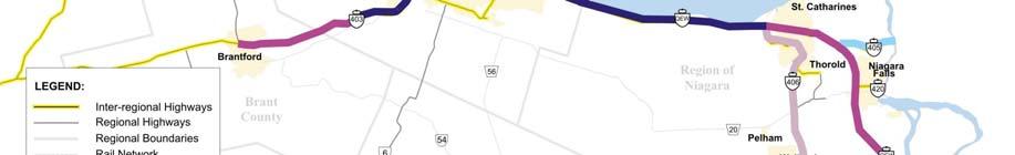
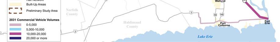
26 4.3.1 Truck rail, marine and air have the capacity to absorb increased goods movement, trucking will continue to play a major role in the transportation of goods. The following sections discuss each mode individually in terms of existing conditions, constraints, future conditions and specific problems identified. The inter-regional road system is the primary mode for goods movement in the area. A Commercial Vehicle Survey (1999, recorded at Putnam) indicates that over half (57%) of all commercial vehicle trips are 500 km or less in length. Additionally, almost half (46%) of all truck trips are within Ontario with an annual commodity value of over $200 million; 52% of all commercial vehicle trips are international in nature with an annual commodity value of over $400 million and a mean travelling distance of more than 1,000 km. Route Type Percent of Trips Annual Commodity Value (M$) Mean Distance (km) Intra-Ontario 46% Inter-Provincial 2% 11 1,095 International 52% 414 1,150 All Trips 100% 634 2,500 Highway 401 is the largest and busiest highway in the GTA West Study Area. As shown in Exhibit 4-18, all of the 400 series highways are heavily used for goods movement throughout the day. In 2006, commercial vehicle volumes in the Study Area were highest on Highway 401, which carries more than 20,000 trucks per day along the majority of its length in the Study Area, with the exception of the section at Milton that carries 10,000-20,000 trucks per day. The Kitchener-Waterloo area is an emerging trucking hub, as industries and logistic firms are relocating from the Toronto Pearson International Airport area to the west along the Highway 401 corridor. Daily truck volumes are also relatively high (between 10,000 and 20,000) on Highway 427 and stretches of Highway 400 (from Highway 401 to north of Highway 407 and again at the Study Area s northern boundary). The shift in trucking logistics firms is expected to result in higher truck volumes on Highway 401 west of Mississauga than would be anticipated with historical trend growth. July 2009 DRAFT Page 126
 in Section 4.2.")
.")


27 Exhibit 4-18: 2006 Daily Commercial Vehicle Volumes As illustrated in Exhibit 4-6 (Annual Average Daily Traffic - AADT) and Exhibit 4-7 (Summer Average Daily Traffic SADT) in Section 4.2.2, all of the Study Area s 400 series highways experience major congestion in 2006 (with the exception of some sections of the 407 ETR, which is not heavily used for truck movements). This congestion is an issue for goods movement, as trucks are the principal means of transporting goods in south-central Ontario, and the existing provincial highway system links to all major manufacturing centres and international border crossings. Further, trucking provides connectivity between rail and marine transport facilities using provincial highways and arterial road networks. The problems associated with commercial vehicle goods movement are therefore of significant concern. It is evident that the major congestion on highway facilities impacts the efficient movement of goods, as Highways 400 and 401 are the primary roads used for the movement of goods within and through the Study Area. Although the majority of the commercial vehicle trips uses the 400 series highways, the extensive road congestion within the GTA West Study Area can result in commercial vehicles shifting to regional and local roads. The extent of the commercial vehicle July 2009 DRAFT Page 127
28 diversion that can occur is presented in Exhibit 4-19, a snapshot of daily commercial vehicle trips to and from Simcoe County located to the north of the Study Area. This area includes the Honda manufacturing plant and several automobile parts manufacturers. Data from the MTO Commercial Vehicle survey indicates that the congestion and unreliability of the Highway 400/Highway 401 interchange complex results in longer distance truck travel using the secondary road network to travel from Simcoe/Highway 400 to Guelph/Highway 401. The secondary roads being used include Highway 89, Highway 9, Highway 50, RR 124 and Hanlon Expressway. This cut-through practice of commercial vehicles using the secondary road system to avoid severely congested areas on the provincial 400 series highways is currently commonplace and will continue to increase as traffic flows increase, thereby increasing associated community, social, noise and safety concerns. Exhibit 4-19: Daily Commercial Vehicle Trips to and from Simcoe County (2006) As the automobile manufacturing industry is one of the major drivers of the trucking industry, reduced activity of the automobile plants will impact trucking activities, especially in the Windsor, Oakville, Oshawa and Alliston areas. However, with the substantial population and employment growth forecast for the GGH in the next 25 years, along with the continued desire of Canada and Ontario to build upon a world class transportation system that will drive international trade and economic growth, the forecast of commercial vehicle volumes increasing by approximately 90% over the next 25 years is considered reasonable. Goods movement in the GTA by commercial vehicles is expected to continue to increase through to Exhibit 4-20 shows the steady increase in commercial vehicle volumes on Highway 401 since July 2009 DRAFT Page 128
29 Exhibit 4-20: Commercial Vehicle Traffic Projections (Hwy 401 East of Highways 403/410) By 2031, truck volumes are expected to increase substantially on all major highways in the Study Area, resulting in increased congestion and delays, particularly on Highways 401, 400, 410 and 427. It is apparent that this major congestion will impact the efficient movement of goods within and through the Study Area. Exhibit 4-21 illustrates the forecast increases in commercial vehicle volumes to The heavy congestion projected on these trucking routes is shown in Exhibit 4-9 (AADT) and Exhibit 4-10 (SADT) in Section July 2009 DRAFT Page 129


30 Exhibit 4-21: 2031 Daily Commercial Vehicle Volumes July 2009 DRAFT Page 130
31 The problems for commercial vehicles travelling in the Study Area are similar to those for commuter and tourism/recreation travel by road. Four key problems emerged from research, consultation and analysis for goods movement by the interregional commercial vehicle system: Travel delays result from recurring congestion during peak periods and increasingly throughout the day Unpredictable travel times on inter-regional roads are a result of incidents on an already congested road system Inadequate road connections between Urban Growth Centres, commercial centres and intermodal facilities Diversion of inter-regional trucks to regional and local roads Major congestion is forecast for the length of Highways 401, 400, 410 and 427, and on parts of the 407 ETR, resulting in increased travel times Demand is anticipated to exceed capacity with substantial capacity shortfalls (in equivalent lane deficiencies): Highway lanes between Guelph and Hwy 400 (except between Hwy 407 ETR and Hwy 410) Highway lanes south of Bovaird Dr. Highway lanes between 407 and Major Mackenzie Dr travel times are expected to increase, in some cases substantially, between Urban Growth Centres Unreliable travel times due to non-recurring incidents (e.g., collisions, inclement weather, maintenance, construction) contribute to high levels of congestion Inadequate connections result from a lack of infrastructure and from congestion on existing facilities, and can result in the use of regional and local roads and circuitous routes Lack of connections impacts the efficiency of goods movement and can create a disincentive to the use of inter-modal facilities Diversion can occur due to a lack of equivalent parallel routes, to avoid congested routes or to avoid unexpected delays A lack of alternate routes suitable for trucks can result in use of regional and local roads, causing community, social, noise and safety concerns July 2009 DRAFT Page 131
. CP and CN provide Class I rail service in south-central Ontario (i.e., they are the largest area freight railways, as classified based on operating revenue) and Class II service is provided by the smaller railroad companies.")
 Terminal and the CN MacMillan Yard Road-Rail Terminal.")


32 4.3.2 Rail A number of rail lines provide services for goods movement within and through the GTA West Study Area, including Canadian Pacific (CP), Canadian National (CN) and a number of shortline railways including the Goderich - Exeter Railway (GEXR). CP and CN provide Class I rail service in south-central Ontario (i.e., they are the largest area freight railways, as classified based on operating revenue) and Class II service is provided by the smaller railroad companies. Inter-modal facilities accommodate the movement of freight between transportation modes. Such facilities within the Study Area include the CP Vaughan Terminal, the CP Trafalgar Road-Rail Terminal, the CN Brampton (Toronto) Terminal and the CN MacMillan Yard Road-Rail Terminal. Typically, rail and inter-modal transportation is used to move bulk goods and containers, including forest products, chemicals, automotive commodities and ores/minerals. Exhibit 4-22 provides an overview of the area rail connections. Exhibit 4-22: Southern Ontario Rail Lines Source: Railway Association of Canada Railway Atlas, November 2004 Rail traffic has experienced strong growth, with a steady increase between 1995 and Much of this growth was driven by marine imports by container. Moving forward, the volume of goods carried by rail is anticipated to increase, as shown in Exhibit This growth in volume is expected to be driven largely by continued growth in the movement of containerized units. July 2009 DRAFT Page 132
33 Exhibit 4-23: Volume of Goods Carried by Rail Source: Trends in Containerization and Capacity at Canadian Ports, Economics Division, January 2006 Rail connections between Urban Growth Centres in the GTA West Corridor are limited in some areas, requiring transfers and circuitous routes: Guelph to Milton no direct connection, circuitous and exchange of traffic required from GEXR to CN to CP Guelph to Brampton connection in place, terminus needed at Brampton Guelph to Vaughan no direct connection, possible exchange of traffic from GEXR to CN to CP Milton to Brampton connection in place Milton to Vaughan no direct connection, exchange of traffic required from CP to CN Brampton to Vaughan no direct connection, exchange of traffic from CN to CP July 2009 DRAFT Page 133
34 Analysis conducted for the current study, supported by background reports and the findings from stakeholder consultation, indicates that three future problems are expected for inter-regional rail goods movement: Limited connectivity of intermodal facilities and growth centres poses constraints to nonroad travel and can produce bottlenecks at the trucking interface Limited rail and road connections reduce efficiency and viability of rail options and increase travel times for deliveries Road congestion at rail inter-modal facilities increases travel times and can affect scheduling to/from local customers Road congestion is affecting the CN Brampton inter-modal terminal and MacMillan yard (Vaughan) Road access at CP Vaughan inter-modal terminal is an issue; improvement is expected from Hwy 427 extension Operational constraints in some areas limit rail options for goods movement Conflicts with transit for the use of rail capacity Potential constraints: introduction/ expansion of passenger services on CP MacTier (Toronto) and Guelph corridors, and CN Halton corridor may require new infrastructure Rail expansion may be constrained by road grade and rail to rail grade separations Progression toward sustainable choices for moving people is occurring in an environment of limited rail capacity and expansion Potential CN passenger-freight conflicts: Bramalea-Georgetown: GO Transit is planning service expansions in primary CN corridor just outside of major freight terminals Potential CP passenger-freight conflicts: currently no passenger services in the Study Area potential GO service from Toronto-Bolton could conflict with freight, particularly at Vaughan inter-modal terminal additional GO service from Toronto-Milton could conflict with Toronto-Chicago corridor Air Although no air transportation facilities are located within the GTA West Corridor, there are several air transportation services in close proximity to the Study Area, as shown in Exhibit The Toronto Pearson International Airport, approximately 3 km to the southeast of the Study Area, is Canada s largest international airport for moving people and goods. Pearson International Airport served over 30 million passengers in 2006 and is ranked 29 th globally for total passenger movements; it is projected to accommodate 66 July 2009 DRAFT Page 134

35 million passengers per year by Also in 2006, 517,000 metric tons of cargo were moved through the airport, positioning the airport as the 28 th busiest in the world for air cargo. Cargo volumes are projected to reach 1.27 million tons by Other airports in the vicinity include Waterloo International, Hamilton International, Buttonville Municipal, Guelph Aerodrome and Toronto City Centre. Air transportation is typically used to ship high value, time-sensitive goods over long distances. Products travelling by air generally include light machinery/electrical goods, manufactured goods, perishable foods, transportation equipment, medical supplies and plastic/chemical products. Exhibit 4-24: Airport Locations Goods movement by air relies on trucking for some portion(s) of the journey to/from the Study Area. Therefore, the problems associated with goods movement by commercial vehicles, discussed in Section 4.3.1, also apply here. Anticipated increased road congestion in the vicinity of Pearson International Airport will increase future travel times to and from the airport in the vicinity of the Study Area, in peak periods and throughout the day, as shown in Exhibit Taking Flight: The Airport Master Plan , GTAA December 2007, Chapter 3 July 2009 DRAFT Page 135
36 Exhibit 4-25: Morning Peak Congestion Indices to Toronto Pearson International Airport 2001 and 2031 Source: Taking Flight: The Airport Master Plan , GTAA December Global air cargo is anticipated to grow significantly through to Exhibit 4-26 shows the expected increase in air cargo demand at Pearson International, particularly transborder and international air cargo, over the next 25 years. Goods movement by air is also becoming increasingly important at HIA, and Waterloo International Airport also provides some air cargo services. Exhibit 4-26: Pearson International Airport Air Cargo Demand Forecast Source: Taking Flight: The Airport Master Plan , GTAA December 2007 As air cargo movements increase into the future, ground transportation requirements will also become greater. Expected increases in road congestion will ultimately affect goods shipped by air, within and through the Study Area. Exhibit 4-25 shows the decrease in morning peak period road accessibility to Pearson International Airport in Runway July 2009 DRAFT Page 136
37 capacity for goods movement is another issue as passenger and air cargo demand at the airport are forecast to increase significantly. Based on Transport Canada forecasts, airside congestion could begin to develop in , with maximum capacity reached by Environmental approval has already been obtained for an additional runway at Toronto Pearson but no definite plans for construction are in place. Plans for a potential airport in Pickering, currently on hold, could relieve some of the capacity constraints at Pearson International Airport but would not be likely to considerably alter the movement of people and goods to, from and through the GTA West Study Area. Future problems associated with goods movement by air have been determined by the Study Team s analysis as well as information gathered from background reports and stakeholder consultation. Again, as trucking is required for the final connection to suppliers and markets, the problems associated with the commercial vehicle transportation system affect air transportation of goods. Two major future problems associated with goods movement by the air transportation system have been identified as follows: Limited multi-modal connections to airports can result in increased dependence on the (often congested) road network Limited runway capacity at Toronto Pearson International Airport will influence the future growth of goods movement by air Existing area roadways are already congested and the forecast is for congestion to worsen A lack of connectivity limit options for goods movement to market/suppliers, which can result in increased travel times and further increased roadway congestion as air cargo movements increase Passenger and goods movements will be restricted by runway capacity constraints in the period and, although environmental approval has been obtained, no firm plans for construction of an additional runway are currently in place Marine Although there are no major marine transportation facilities within the GTA West Study Area, the Port of Hamilton and the Port of Toronto are two major facilities in relatively close proximity to the south and east, along the Great Lakes St. Lawrence Seaway. Other marine facilities in the vicinity of the Study Area include the Welland Canal, Port Dalhousie, Port Colborne and Petro Canada-Oakville. Marine transportation is generally used to carry bulk goods and containers, including grain, coal, iron ore and steel, as well as general cargo and consumer goods. Typically, this mode is used for long distance shipments of large quantities of goods, and is costeffective for long distance shipments compared to other transportation options. 13 Source: Taking Flight: The Airport Master Plan , GTAA December 2007 July 2009 DRAFT Page 137


38 There are a number of major marine facilities in the vicinity of the Study Area, including the following: The St. Lawrence Seaway the Seaway is a deep waterway connecting the Atlantic Ocean to the Great Lakes, extending from Montreal to Lake Erie, and the Welland Canal is a component of it connecting Lake Ontario and Lake Erie. The Seaway can accommodate vessels with a maximum length of m 14 (a number of large container ships are over 300 m in length 15 ). Area marine transportation facilities have a limited operating period as the St. Lawrence Seaway closes during the winter season. Port of Hamilton in 2007 the Port of Hamilton handled approximately 11.8 million tons of cargo and was visited by 750 vessels 16. Port of Toronto the Port of Toronto (located outside of the Study Area) is one of the largest city and inland ports in Canada, moving 2.1 million tonnes of cargo in Marine transportation is generally used more for overseas trade than for trade between Canada and the U.S. 18. Trends in marine cargo traffic indicate a relatively consistent movement of goods by this mode over the past fifteen years. As shown in Exhibit 4-27, the main commodities transported by the St. Lawrence Seaway in 2007 were iron ore and grain. Exhibit 4-27: St Lawrence Seaway Traffic by Commodity Source: Transport Canada, Transportation in Canada 2007: An Overview, May St Lawrence Seaway web site ( 15 Container ship database ( 16 Hamilton Port Authority web site ( 17 Toronto Port Authority web site ( 18 Transport Canada, Transportation in Canada 2007: An Overview, May 2008 July 2009 DRAFT Page 138
39 Goods movement by marine transportation can be limited by bottlenecks at locations that interface with rail/trucking. From the Great Lakes/St. Lawrence Seaway ports, a multimodal transportation network extends across the province and beyond. As marine transportation eventually relies on trucking to connect with suppliers and markets, the problems associated with goods movement by commercial vehicles also apply to it. Due to the global nature of marine shipping, conditions around the world impact the future potential of marine transportation within the Study Area. As seen in Exhibit 4-28, trends on the St. Lawrence Seaway indicate that cargo tonnage is expected to remain relatively consistent, fluctuating with western Canadian crop yields and demands for coal. Exhibit 4-28: Historical Marine Tonnage on the St. Lawrence Seaway 45,000 Historical Marine Tonnage on St. Lawrence Seaway 1000 Tonnes 40,000 35,000 30,000 25,000 20,000 15,000 10,000 5,000 Tonnage through the Welland Canal will likely remain relatively constant, fluctuating with Western Canadian crop yields and demand for coal Year Montreal-Lake Ontario Welland Canal Source: Transport Canada, Transportation in Canada 2007: An Overview, May 2008 (historical data only) * Trends based on extrapolation from reported past St. Lawrence Seaway shipments There is potential for this flat growth trend to change by improved infrastructure and policy measures for short-sea shipping (movement of cargo by inland waterways, within the same continent). Such services could provide environmental benefits and relieve highway congestion, and have been actively promoted in Europe by the European Commission since the early 1990s. Transport Canada and the U.S. Maritime Administration are investigating the feasibility of short-sea shipping across the Great Lakes. July 2009 DRAFT Page 139
40 Analysis, background reports and stakeholder consultation indicate that future problems associated with goods movement by marine transportation are anticipated. Future problems associated with goods movement by the marine transportation system are as follows: Inadequate connections between inland ports and the inter-regional road system, and limited capacity of the road system pose constraints on the effectiveness and efficiency of marine transportation of goods Large ocean vessels being unable to enter the St. Lawrence Seaway results in goods being transferred to rail or truck Congestion can result in increased travel times for shipments and further increased roadway congestion where rail-marine connections are unavailable Insufficient connections to the higher order roadway network can result in the use of local and regional roads Early transfer from marine to rail and truck can reduce the effectiveness of marine transportation for goods movement to southcentral Ontario The Seaway s limitations increase the importance of multi-modal connections with trucking/rail routes into the Study Area The result can be additional trucks shipping goods for longer distances than would be required where vessels can reach ports farther inland Winter Seaway closure limits the shipping season, which reduces potential year-round customers and can result in increased dependence on other modes The Seaway s winter limitations increase dependence on rail and truck transportation into south-central Ontario July 2009 DRAFT Page 140
41 4.4 Community, Environment and Economic Effects The transportation problems associated with the inter-regional movement of people and goods have wider implications for the implementation of provincial policies relating to the community, environment and economy. As outlined in Section 1.5.2, goals and objectives for this study were developed based on relevant approved planning policies and in support of the triple bottom line philosophy comprised of the following three factors: Compact, vibrant and complete communities; A prosperous and competitive economy; and A protected environment. The effects on these key factors are outlined below. Community Road congestion results in increased costs (i.e. travel time, fuel costs) for goods movement which is passed on to consumers Congested roadways increase potential for traffic collisions Trucks using secondary routes impact communities, increase deterioration of infrastructure and increase conflicts with cyclists and pedestrians Reduced quality of life from time lost to commuting Lack of transit services and large volumes of heavy trucks on the interregional road system may deter tourists/recreational travellers Potential for job losses with reduced tourism Environment Congestion increases fuel consumption and increases air and noise emissions Economic Congestion and travel time uncertainty reduces economic competitiveness of local businesses and industries and results in excessive wear on vehicles Businesses are less likely to expand or be attracted to areas with major congestion Congestion negatively impacts the shipping industry and the effectiveness of all inter-modal travel Reduced tourism negatively affects the economies of GTA July 2009 DRAFT Page 141
42 5. IDENTIFICATION OF SPECIFIC TRANSPORTATION PROBLEMS OUTSIDE THE STUDY AREA The transportation system problems and opportunities discussed in the previous sections focused on the specific problems and opportunities within the Study Area as well as the broader transportation system issues adjacent to the Study Area. Within the area of influence shown in Exhibit 1-4, there are specific areas where existing transportation problems indirectly impact the GTA West transportation network. The following discussion provides an overview of these issues & 401 Interchange The Highway 401 and Highway 400 interchange complex currently accommodates weekday daily traffic volumes in the order of 600,000 vehicles and upwards of 650,000 vehicles on a typical summer weekday. The significant traffic volume in conjunction with current ramp configurations and a high percentage (10%) of commercial vehicles results in this interchange complex operating in a congested state for several hours every day of the week. These factors contribute to major collision occurrences on the ramps. It is not uncommon to have an overturned tractor-trailer that effectively prevents traffic flows at specific ramps for a long period of time until the debris has been collected and the vehicle towed off site. The extremely high traffic flows in a congested environment at the interchange complex result in a certain degree of travel unreliability (operating Level of Service, travel time, etc.) that motivates the travelling public to alter their travel routes by using the secondary road system (highways, arterial roads, etc.). At the GTA West Public Information Centres (PICs) held in March 2009, several members of the public noted that residents of Wellington County and North Halton (Milton, Georgetown) areas prefer to utilize the secondary roads to travel to the tourist/recreation areas of Muskoka and Haliburton due to the travel reliability of these roads over the unreliability of the Highway 400/Highway 401 interchange complex. The trucking industry also changes travel patterns to avoid the unreliable travel characteristics. Public comments from both PIC #1 and PIC #2 indicated that over the last decade, there has been a noticeable increase in the amount of truck traffic that uses the secondary road system to travel between the Highway 400 corridor and the Guelph/Highway 6/Highway 401 area. An example of the recorded truck diversion using the secondary road system is shown in Exhibit The transportation system congestion and unreliability of travel associated with the Highway 400 and Highway 401 interchange complex is an important element of the transportation system that has a bearing on traffic operations in the GTA West Study Area Cambridge to Guelph Link (Regional Road 24/124) Originally, Highway 24 provided a major north-south transportation link in the province of Ontario extending from Lake Erie northerly some 250 km to Collingwood on the shores of Georgian Bay. In 1998, the Ministry of Transportation (MTO) transferred jurisdiction for the 64 km section of Highway 24 from Highway 401 at Cambridge to July 2009 DRAFT Page 142
43 Highway 9 to municipalities that it passed through (Waterloo Region, Wellington County and Peel Region). Specific to the 11 km section of Former Highway 24 (RR 24 / CR 124) between the City of Cambridge (Highway 401) and the City of Guelph (Highway 6), MTO undertook an Environmental Study Report in 1996 that indicated that there was justification for this section of road to be widened to a four-lane facility. The County of Wellington Report, Role and Function of Former Highway 24 from Highway 401 at Cambridge to Highway 10 at Caledon (2007), indicated that this section of road functions as an integral part of a significant longer economic corridor, and that this corridor serves as a bypass for the congested GTA highway system for travel between Highway 401 west of Waterloo Region and locations north of the GTA. Traffic counts undertaken in 2007 indicate that the section of Former Highway 24 (RR 24/CR 124) between Highway 401 and Highway 6 accommodates upwards of 24,000 vehicles per day on the existing two-lane cross-section with upwards of 1,000 vehicles observed in the peak direction in the afternoon peak hour. A summary of the typical weekday and weekend daily traffic flows are presented in Exhibit 5-1. Generally, the weekend traffic flows are approximately 25% to 30% lower than the weekday traffic flows. Exhibit 5-1: Summary of Year 2007 Weekday and Weekend Traffic Flows RR 24 / CR 124 Traffic Count Locations Weekday Daily Vehicles Weekend Daily Vehicles NB SB Total NB SB Total North of Wellington Road 32 7,130 7,250 14,380 5,070 5,180 10,250 Wellington Road 32 to Township Road 1 Township Road 1 to Maple Grove Road South of Maple Grove Road to Highway 401 9,140 9,090 18,230 6,080 5,970 12,050 11,710 12,630 24,340 8,800 9,720 18,520 11,830 11,740 23,570 7,780 7,620 15,400 A typical weekday and weekend traffic profile for RR 24 northeast of Maple Grove Road is presented in Exhibit 5-2. The weekday traffic profiles indicate that the morning commuter travel peak occurs between 7:00 AM and 8:00 AM on a typical weekday, whereas the afternoon commuter travel peak occurs between 5:00 PM and 6:00 PM. The weekend traffic profile indicates that traffic peaks during the midday (10:00 AM to 5:00 PM). July 2009 DRAFT Page 143
44 Exhibit 5-2: RR 24 Typical Weekdays and Weekend Traffic Profiles RR 24 - North-East of Maple Grove 2-Way Traffic Traffic Volume NB+SB 2 Way Weekday NB+SB 2 Way Weekend Traffic AM 1 AM 2 AM 3 AM 4 AM 5 AM 6 AM 7 AM 8 AM 9 AM 10 AM 11 AM 12 PM Time of Day 1 PM 2 PM 3 PM 4 PM 5 PM 6 PM 7 PM 8 PM 9 PM 10 PM 11 PM To assess existing and future operating conditions, roadway Levels of Service (LOS) calculations were performed for both existing and forecast PM peak hour volumes at specific road sections along RR 24/CR 124. The HCS-2000 Two Lane Capacity Analysis Process was applied to assess LOS for the two-lane highway segments and the HCS Multilane Capacity Analysis Process was used to assess LOS for the fourlane segment. The existing (2007) peak hour volumes and resulting LOS analysis for the existing lane geometry are presented in Exhibit 5-3. The LOS analysis indicates that CR 124 north of Wellington Road 32 is currently operating at LOS D which reflects an Unstable condition (see Section for operating condition descriptions). The roadway segment from Wellington Road 32 to Maple Grove Road is currently operating at LOS E, which reflects a Congested condition. RR 24 from south of Maple Grove Road to Highway 401 is a 4-lane highway facility. The LOS analysis for this segment indicates that it is currently operating at LOS B. July 2009 DRAFT Page 144
45 Exhibit 5-3: Existing (2007) PM Peak Hour Volumes and Operation LOS RR 24 / CR 124 Existing PM Peak Hour Vehicles Operating Level of Service and V/C Ratio Traffic Count Locations NB SB Total LOS North of Wellington Road D Wellington Road 32 to Township Road ,044 1,778 E Township Road 1 to Maple Grove Road 1, ,066 E South of Maple Grove Road to Highway 401 (4-lane Highway) 1,033 1,044 2,077 B The forecast (2031) total vehicles were calculated by using assigned automobile volumes from the GGH Model and assuming that trucks and buses represent 10% of total vehicles. The forecast 2031 PM peak hour traffic volume and associated LOS by road segment are presented in Exhibit 5-4. The LOS analysis indicates that the road section of CR 124 from north of Township Road 1 is anticipated to operate at LOS E, reflecting a congested operating condition. The CR 124 / RR 24 road segments from Township Road 1 to Maple Grove Road are forecast to operate at a Congested state. The four-lane segment of RR 24 from south of Maple Grove Road to Highway 401 is anticipated to operate at LOS D, which reflects Unstable operating condition. The LOS analysis in relation to the existing lane geometry indicates that RR 24 north of Maple Grove Road is expected to operate in a Congested state if no additional road capacity is provided. Exhibit 5-4: Future (2031) PM Peak Hour Volumes and Operation LOS RR 24 / CR 124 Traffic Count Locations Year 2031 PM Peak Hour Vehicles Operating Level of Service NB SB Total LOS North of Wellington Road E Wellington Road 32 to Township Road 1 1,109 1,101 2,210 E Township Road 1 to Maple Grove Road 1,286 1,297 2,583 F South of Maple Grove Road to Highway 401 (4-lane Highway) 1,745 1,856 3,6011 D As noted, CR 124 provides a key transportation linkage between the City of Guelph and the City of Cambridge. The 2006 Transportation Tomorrow Survey (TTS) database indicates upwards of 1,900 person trips interact between the Cities during the PM peak hour. This interaction is forecast to increase by over 30% by year A review of future 2031 PM peak hour travel flows on CR 124 northeast of Maple Grove Road indicate that approximately 30% of the forecast traffic on CR 124 is traffic travelling between the City of Cambridge and the City of Guelph. These travel characteristics suggest that CR 124 currently provides an inter-regional travel role for longer distance travel in the overall GGH transportation system. July 2009 DRAFT Page 145
46 6. IDENTIFICATION OF TRANSPORTATION OPPORTUNITIES This section describes the Study Team s assessment of the inter-regional transportation opportunities in the Study Area. While prior sections of this report have focused on the inter-regional transportation problems that have been identified with the multi-modal transportation system within the Study Area, transportation opportunities are an equally important consideration. A key measure of the success of this study will be its ability to not only address the current and future transportation problems, but also to capitalize on the significant opportunities of providing a more balanced, robust and higher order transportation system which offers greater reliability, flexibility and choice for moving people and goods in the western part of the Greater Toronto Area (GTA) and beyond. In the context of this study, the term transportation opportunities refers to the big picture strategic benefits of an efficient transportation system. Given the scale and strategic nature of this study as well as the early planning stage that this study represents, a visionary approach is required, which entails viewing the multi-modal transportation system within the Study Area as a whole and identifying ways of using the system to achieve the broader strategic goals and objectives of the study. These goals and objectives are summarized in Section of this report and again in later paragraphs of this chapter. The Study vision built upon existing approved provincial planning policies on community and economic development, and environmental protection. The identification of transportation opportunities at this stage of the process does not involve identifying solutions to specific transportation safety, operational or capacity problems within the Study Area. Rather, the focus is on identifying ways of enhancing the existing inter-regional multi-modal transportation system to support the principles of the triple bottom line philosophy consistent with the provincial planning context upon which this project is founded: compact, vibrant and complete communities, a prosperous and competitive economy, and a protected environment. While the transportation opportunities identified are relatively broad in nature, it is envisioned that as the project proceeds through the development of the transportation alternatives, and ultimately to the identification of a multi-modal Transportation Development Strategy (TDS), the opportunities will continue to become more refined but will remain generally consistent with the broader opportunities described in this report. These transportation opportunities stem from the study goals and objectives, building upon existing approved provincial planning policies on community and economic development, and environmental protection. These policies, which are described in greater detail in Section 2.2 of this report, include the Growth Plan, the Provincial Policy Statement and the Greenbelt Plan, among many others. In addition, the Study Team reviewed municipal official plans of each upper and single tier municipality Region of Peel, Region of Halton, Region of York, City of Guelph and the County of Wellington. The policies embodied in each of these approved planning documents formed the foundation for the study goals and objectives that have been identified by the Study Team as described in Section July 2009 DRAFT Page 146
47 6.1 Transportation Opportunities The transportation opportunities further build upon the study goals and objectives discussed above, and are described in the following paragraphs. 1. Support Future Municipal Land Use Planning in Accordance with the Growth Plan The Metrolinx RTP has been developed based on an assumed future land use allocation for the GTHA that has been derived through consultation with GTHA municipalities, and is in accordance with the requirements of the Growth Plan. As the conformance exercise is ongoing, the land use allocation assumed for the Metrolinx RTP is based on current municipal thinking but may be further refined as the conformity exercise progresses. The Study Team has consulted with the Region of Peel, Region of York, Region of Halton, City of Guelph and County of Wellington to obtain insight as to how they plan to allocate the Growth Plan s future population and employment growth. This knowledge will enable the Study Team to model and forecast future transportation demands as accurately as possible and to develop transportation alternatives that will accommodate these demands. Ongoing consultation with each municipality will be undertaken throughout the remainder of the study to stay abreast of their plans with regard to future land use allocation and to co-ordinate the development of the transportation alternatives with the planning work that is being undertaken by these municipalities. The Region of Halton has provided the Study Team with insight into their future land use allocation intentions. There are currently five scenarios under consideration, which include: Scenario 1: Milton-Centred all new mixed-use/residential development area is located in Milton; Scenarios 2a and 2b: Milton-Georgetown (Low) approximately 20,000 people are allocated around Georgetown in two potential configurations, with the remaining mixed-use/residential lands in Milton; and Scenarios 3a and 3b: Milton-Georgetown (High) approximately 40,000 people are accommodated in Georgetown, again in two potential configurations, with a smaller amount of remaining mixed-use/residential land in Milton. The broader land use concepts are illustrated in Exhibit 6-1. There is an opportunity to co-ordinate with the Region of Halton during the development of the transportation alternatives as a preferred land use option is identified. July 2009 DRAFT Page 147

48 Exhibit 6-1: Sustainable Halton Land Use Concepts Source: Sustainable Halton Working Paper #3, Options Under the Preferred Concept, Regional Municipality of Halton, April 2009 In addition to developing alternatives that support the land use aspirations of the municipalities, the opportunity exists to co-ordinate with municipal land use planning staff in developing land use scenarios that optimize potential transportation alternatives, such as inter-modal facilities. Co-location of warehouse/ distribution centres in proximity to a potential inter-modal facility would support industrial/ employment development in the municipality while at the same time optimizing the function of the inter-modal facility. This type of arrangement could improve the efficiency of moving goods in the Study Area, as well as reduce some truck traffic between warehouses and retail outlets. Similarly, considering connections to the Study Area s designated Urban Growth Centres (Vaughan Corporate Centre, Downtown Brampton, Downtown Milton and Downtown Guelph) during the development of the transportation alternatives provides the opportunity to create quality communities for a diverse population, an enhanced environment with heritage and culture, and a vibrant economy. In addition, through review of the Region of Peel s Official Plan, as well as consultation with the Region, it is understood that the Region has begun a new initiative, Liveable Peel, which extends the goals and objectives of the province to the Region s municipalities. This initiative complements the province s strong commitments to a policy framework that improves future communities through balanced planning with respect to environmental, social, economic and cultural issues. The Liveable Peel policy framework has been established with the following objectives: July 2009 DRAFT Page 148
EXECUTIVE SUMMARY 1. OVERVIEW OF TRANSPORTATION PROBLEMS AND OPPORTUNITIES
 EXECUTIVE SUMMARY 1. OVERVIEW OF TRANSPORTATION PROBLEMS AND OPPORTUNITIES The GTA West Corridor has been identified in the Growth Plan for the Greater Golden Horseshoe as a future transportation corridor,
TRANSPORTATION DEMAND FORECASTING INFORMATION SESSION
 GTA WEST CORRIDOR PLANNING AND EA STUDY-STAGE STAGE 1 TRANSPORTATION DEMAND FORECASTING INFORMATION SESSION JUNE 2008 Topics for this Session 1. The Challenge of Growth 2. Overview of GTAW Study 3. The
3. SYSTEM ANALYSIS Future (2031) AADT and SADT Estimates
 AADT and SADT Estimates") 3. SYSTEM ANALYSIS 3.1 Congestion Analysis As indicated in Section 2.1, a key component of the GTAW Corridor Planning and Environmental Assessment Study is the assessment of the inter-regional travel demands
3. SYSTEM ANALYSIS 3.1 Congestion Analysis As indicated in Section 2.1, a key component of the GTAW Corridor Planning and Environmental Assessment Study is the assessment of the inter-regional travel demands
Niagara Region Transportation Master Plan Niagara-Hamilton Trade Corridor Technical Paper
 Niagara-Hamilton Trade Corridor Technical Paper 1. Purpose In the report to Council on the Regional Council Strategic Priorities Implementation Plan, pursuing Provincial commitment for the Niagara to Greater
To provide an update on the progress of the Peel Goods Movement Task Force and Peel Goods Movement Strategic Plan.
 8.4-1 REPORT Meeting Date: 2014-06-26 Regional Council For Information DATE: June 17, 2014 REPORT TITLE: PEEL GOODS MOVEMENT STRATEGIC PLAN UPDATE 2014 FROM: Dan Labrecque, Commissioner of Public Works
GTA West GTA WEST CORRIDOR PLANNING AND EA STUDY-STAGE STAGE 1. Study Update NOVEMBER 2009
 GTA WEST CORRIDOR PLANNING AND EA STUDY-STAGE STAGE 1 Study Update NOVEMBER 2009 Meeting Agenda 1. Welcome and Introductions 2. GTA West Study Update 3. Background 4. Transportation Alternatives and Process
Greater Golden Horseshoe Transportation Plan
 Greater Golden Horseshoe Transportation Plan Transportation Profile Executive Summary October 2017 PREPARED BY Urban Strategies Inc. and HDR for the Ministry of Transportation TRANSPORTATION PROFILE -
GTA West Corridor Environmental Assessment. Executive Summary - November Transportation Development Strategy Report
 GTA West Corridor Environmental Assessment Transportation Development Strategy Report Executive Summary - November 2012 GTA West Corridor Environmental Assessment Executive Summary 1 Table of Contents
Recommendation: Oppose the Ministry of Transportation s preferred alternative for
 Page 1 of Report TO: Community Services Committee Community Services SUBJECT: Niagara to GTA (N-GTA) Corridor EA: Area Transportation System Alternatives Report Update Report Number: Report Date: June
Presentation to Agencies
 GTA WEST CORRIDOR PLANNING AND EA STUDY-STAGE STAGE 1 Presentation to Agencies May 2010 Outline of Presentation 1. Study Background and Process 2. Transportation Development Strategy Group #1 Optimize
To provide an update on the progress of the Peel Goods Movement Task Force and the Peel Goods Movement Strategic Plan.
 9.2-1 REPORT Meeting Date: 2015-11-26 Regional Council For Information DATE: November 10, 2015 REPORT TITLE: REGION OF PEEL GOODS MOVEMENT STRATEGIC PLAN - 2015 STATUS UPDATE FROM: Dan Labrecque, Commissioner
City of Brantford Chapter 3 TABLE OF CONTENTS
 Chapter 3 The Land Use & Transportation Connection TABLE OF CONTENTS 3.1 THE LAND USE & TRANSPORTATION LINK... 1 3.2 POPULATION & EMPLOYMENT GROWTH FORECASTS... 3 3.2.1 Proposed Places to Grow Plan Forecasts
Peel Goods Movement Task Force Meeting Action Items & Subcommittee Updates March 28, 2014
 Peel Goods Movement Task Force Meeting Action Items & Subcommittee Updates March 28, 2014 Goods Movement Task Force Subcommittee # 1 Infrastructure Improvements Action Items Purpose: Action 1: Prioritize
APPENDIX F1 Legislative Context
 APPENDIX F1 Legislative Context Halton Region Transportation Master Plan Legislative Context Contents Page 1. LEGISLATIVE CONTEXT...1 1.1 2005 Provincial Policy Statement...3 1.2 Greenbelt Act (2005)...3
EXECUTIVE SUMMARY ORGANIZATION OF REPORT
 EXECUTIVE SUMMARY Over the past year, the Dillon Consulting team conducted a comprehensive review of public transit in Guelph. The City of Guelph has for many years been a leader among Canadian municipalities
GTA West Corridor Environmental Assessment Study. Transportation Development Strategy Report - November 2012
 GTA West Corridor Environmental Assessment Study Transportation Development Strategy Report - November 2012 Table of Contents Executive Summary - Under Separate Cover 1. INTRODUCTION...1 1.1. STUDY BACKGROUND...1
407 TRANSITWAY WEST OF HURONTARIO STREET TO EAST OF HIGHWAY 400 MINISTRY OF TRANSPORTATION - CENTRAL REGION
 Executive Summary 407 TRANSITWAY WEST OF HURONTARIO STREET TO EAST OF HIGHWAY 400 MINISTRY OF TRANSPORTATION - CENTRAL REGION TABLE OF CONTENTS E. EXECUTIVE SUMMARY E-1 E.1. Background E-1 E.1.1. 407 Transitway
Public Information Centre #1. March 2010
 Public Information Centre #1 March 2010 Purpose of Public Information Centre Halton Region is initiating a Transportation Master Plan (2031) The Road to Change The Plan will develop a sustainable, integrated
Metrolinx s GTHA Urban Freight Action Plan Peel Goods Movement Task Force
 Metrolinx s GTHA Urban Freight Action Plan Peel Goods Movement Task Force Lisa Salsberg Manager Strategic Policy & Systems Planning May 4th, 2012 1 Greater Toronto and Hamilton Area Today 6 million people
Niagara s Transportation Strategy 1. Introduction:
 Niagara s Transportation Strategy May 8, 2002 Niagara s Transportation Strategy 1. Introduction: Transportation is of pivotal importance in the development of Niagara. This, Niagara s first comprehensive
Moving into the Future Workshop
 Moving into the Future Workshop Importance of Multi-modal Transportation Planning on Ontario s Economy May 9, 2014 1 Municipal Network -Initiatives City of Hamilton Chris Murray, City Manager Region of
407 TRANSITWAY - KENNEDY ROAD TO BROCK ROAD MINISTRY OF TRANSPORTATION - CENTRAL REGION
 Executive Summary 407 TRANSITWAY - KENNEDY ROAD TO BROCK ROAD MINISTRY OF TRANSPORTATION - CENTRAL REGION E. EXECUTIVE SUMMARY E.1. E.1.1. Background 407 Transitway Background and Status The planned 407
Niagara Region Transportation Master Plan Road Network Strategy Technical Paper
 [Type here] Niagara Region Transportation Master Plan Table of Contents 1 Purpose... 1 2 Background... 1 3 Network Assessment Approach... 2 4 Road Network... 3 4.1 Queen Elizabeth Way... 3 4.2 NGTA Corridor
Metrolinx wishes to acknowledge the invaluable contribution of IBI Group to the preparation of this backgrounder.
 Modelling December 2008 1. Introduction This is one in a series of backgrounders that have been produced by Metrolinx to provide further explanation and clarification on the Regional Transportation Plan
Workshop #3 Needs Assessment. Ministry of Transportation IBI Group March 27, 2014
 Workshop #3 Ministry of Transportation IBI Group Opening Remarks and Introductions page 1 Study Overview and Update page 2 History of the Study This study builds upon the 2002 MTO study Simcoe Area Transportation
1.0 INTRODUCTION Study Context Study Approach LITERATURE REVIEW... 3
 Table of Contents EXECUTIVE SUMMARY 1.0 INTRODUCTION... 1 1.1 Study Context... 1 1.2 Study Approach... 2 2.0 LITERATURE REVIEW... 3 2.1 Review of Literature and Guidelines... 3 2.2 Exposure Indices...
Groupings of Public Information Centre #5 Displays
 Welcome Groupings of Public Information Centre #5 Displays Welcome to Public Information Centre #5. Displays have been organized into four groups as follows: Provides an overview of the study purpose,
Northern Virginia Region Draft Needs Summary
 Needs Map: Need A A DEMAND The ability of communities around transit stations (particularly the areas within 1-2 miles of the stations and other travel hubs) to attract skilled workers and grow businesses
Chapter 1 Introduction
 Chapter 1 Introduction 407 TRANSITWAY WEST OF HURONTARIO STREET TO EAST OF HIGHWAY 400 MINISTRY OF TRANSPORTATION - CENTRAL REGION TABLE OF CONTENTS 1. INTRODUCTION 1-1 1.1. 407 Transitway Background and
TECHNICAL REPORT 2001 GTA CORDON COUNT TRANSPORTATION TRENDS Prepared on behalf of:
 21 GTA CORDON COUNT TRANSPORTATION TRENDS 1991-21 TECHNICAL REPORT Prepared on behalf of: Ministry of Transportation, Ontario Regional Municipality of Durham Regional Municipality of Halton Regional Municipality
APPENDIX I PUBLIC INFORMATION CENTRE #2 STUDY BROCHURE AND FACTSHEETS
 APPENDIX I PUBLIC INFORMATION CENTRE #2 STUDY BROCHURE AND FACTSHEETS Strategies to Protect Corridor Options Address immediate local planning needs and development pressures Uphold integrity of the planning
Greater Golden Horseshoe Transportation Plan
 Greater Golden Horseshoe Transportation Plan Transportation Profile November 2017 PREPARED BY Urban Strategies Inc. and HDR for the Ministry of Transportation Prepared by Urban Strategies Inc. and HDR
TORONTO REGION BOARD OF TRADE
 Photo credit: H4vok_13 via Foter.com TORONTO REGION BOARD OF TRADE Movement of Goods Initiative Update November 27, 2018 Toronto Region Board of Trade Transportation Summit 4.0 1 Toronto Region Board of
Executive Summary i Regional Transportation Plan March 2018
 Executive Summary i Regional Transportation Plan March 2018 Executive Summary ii iii 2041 Regional Transportation Plan The Greater Toronto and Hamilton Area (GTHA) is one of the fastest growing regions
2001 GTA CORDON COUNT TRANSPORTATION TRENDS McCormick Rankin Corporation. Prepared on behalf of:
 2001 GTA CORDO COUT TRASPORTATIO TREDS 1991 2001 Prepared on behalf of: Ministry of Transportation, Ontario Regional Municipality of Durham Regional Municipality of Halton Regional Municipality of Peel
Niagara Region Transportation Master Plan Goods Movement Technical Paper
 [Type here] Niagara Region Transportation Master Plan Table of Contents 1 Purpose... 1 2 Background Studies Concerning Goods Movement and Industry in Niagara... 1 2.1 Niagara Region s Economic Growth Strategy
Sabbir Saiyed, PhD., P.Eng. Manager, Transportation System Planning
 Sabbir Saiyed, PhD., P.Eng. Manager, Transportation System Planning February 5, 2016 Goods Movement is a Major Part of Peel s Economy Peel is one of Canada s most important freight hubs Close to major
407 TRANSITWAY FROM EAST OF HIGHWAY 400 TO KENNEDY ROAD. Planning & Preliminary Design
 FROM EAST OF HIGHWAY 400 TO KENNEDY ROAD GWP 252-96-00 Public Information Centre #1 Study Purpose & Scope The purpose of the study is to: Design a high-speed cross-regional transit facility to be constructed
GO RAIL NIAGARA SERVICE EXTENSION
 Business Case: Finch Avenue West Rapid Transit GO RAIL NIAGARA SERVICE EXTENSION INITIAL BUSINESS CASE Date: November, 2014 NOVEMBER 2015 Page 1 TABLE OF CONTENTS 1.0 Executive Summary...p.5 2.0 Introduction....p.6
REGIONAL EXPRESS RAIL (RER)
") REGIONAL EXPRESS RAIL (RER) September 5, 2014 Metrolinx Board of Directors Greg Percy, President GO Transit Purpose of Today s Presentation Provide the Board of Directors with an update on the work that
REGIONAL EXPRESS RAIL (RER) September 5, 2014 Metrolinx Board of Directors Greg Percy, President GO Transit Purpose of Today s Presentation Provide the Board of Directors with an update on the work that
NEED ECONOMIC TRANSPORTATION LOCATIONS EXAMPLE
 A. Enhance multimodal networks and facilities around transit access points such as existing and emerging rail stations, high capacity bus stops, and intermodal transfer centers There is a need for improved
VTrans2040 Multimodal Transportation Plan Corridors of Statewide Significance Needs Assessment Western Mountain Corridor (L)
") VTrans2040 Multimodal Transportation Plan Corridors of Statewide Significance Needs Assessment Western Mountain Corridor (L) 77 Table of Contents I. Corridor Overview Land Use and Demographics Corridor
VTrans2040 Multimodal Transportation Plan Corridors of Statewide Significance Needs Assessment Western Mountain Corridor (L) 77 Table of Contents I. Corridor Overview Land Use and Demographics Corridor
APPENDIX F INDIVIDUAL TSP/BCS TECHNICAL MEETING SUMMARY NOTES
 APPENDIX F INDIVIDUAL TSP/BCS TECHNICAL MEETING SUMMARY NOTES Location: 777 Bay Street, 30 th Floor, Exec. Bdrm Date: Friday February 19, 2010 Purpose: Present: Joint Meeting with Metrolinx, GO Transit
DATE: January 20, 2014 REPORT NO. PW Chair and Members Committee of the Whole Operations and Administration
 PUBLIC WORKS COMMISSION DATE: January 20, 2014 REPORT NO. PW2014-007 TO: FROM: Chair and Members Committee of the Whole Operations and Administration Geoff Rae, MBA, P.Eng. General Manager, Engineering
E X E C U T I V E S U M M A R Y BUSINESS CASE. - June CAMBRIDGE ON THE GO BUSINESS CASE page 1
 E X E C U T I V E S U M M A R Y BUSINESS CASE - June 2015 CAMBRIDGE ON THE GO BUSINESS CASE page 1 E X E C U E T X I E V C E U S T U I V M E M S A U R M Y M A R Y EXECUTIVE SUMMARY The partnering communities
Welcome to Public Information Centre #3
 GTA West Public nformation Centre #3 Welcome to Public nformation Centre #3 Members of the Project Team are available to discuss your comments and questions Please sign in GTA West McCORMCK RANKN CORPORATON
DRAFT. Report C: Area Transportation System Problems and Opportunities. Highway 7&8 Transportation Corridor Planning and Class EA Study
 Ministry of Transportation Highway 7&8 Transportation Corridor Planning and Class EA Study Greater Stratford to New Hamburg Area MTO Group Work Project # 13-00-00 Report C: Area Transportation System Problems
SOUTHWEST LRT (METRO GREEN LINE EXTENSION)
") 8 Evaluation of Alternatives This chapter evaluates the effectiveness of the No Build Alternative and the Southwest Light Rail Transit (LRT) Project (the Project) based on the information contained in
8 Evaluation of Alternatives This chapter evaluates the effectiveness of the No Build Alternative and the Southwest Light Rail Transit (LRT) Project (the Project) based on the information contained in
An Integrated Transport - Economics Model for Ontario
 An Integrated Transport - Economics Model for Ontario by Sundar Damodaran, Ph.D., P.Eng. Ministry of Transportation, Ontario Paper prepared for presentation at the Travel Demand Modeling: Applications
Simcoe Area Transportation Network Needs Assessment. Executive Summary
 Simcoe Area Transportation Network Needs Assessment Executive Summary June 2002 Simcoe Area Transportation Network Assessment PREFACE A safe, efficient and integrated transportation system supports economic
407 TRANSITWAY. Planning & Preliminary Design
 FROM EAST OF HIGHWAY 400 TO KENNEDY ROAD GWP #252-96-00 Public Information Centre #2 June 24 th and 29 th, 2010 Purpose of Public Information Centre #2 The first Public Information Centre (PIC #1) was
CITY OF OSHAWA ITMP THE CORPORATION OF THE CITY OF OSHAWA INTEGRATED TRANSPORTATION MASTER PLAN
 CITY OF OSHAWA ITMP THE CORPORATION OF THE CITY OF OSHAWA INTEGRATED TRANSPORTATION MASTER PLAN DRAFT REPORT FEBRUARY 2015 Table of Contents 1.0 INTRODUCTION A USER S GUIDE... 1 1.1 What does the Integrated
Evaluation of Alternatives
 Chapter 9.0 Evaluation of Alternatives Chapter 9.0 provides a summary evaluation of the No Build Alternative and the Preferred Alternative. The evaluation contained within this chapter is an assessment
INDIANA S INTERMODAL MANAGEMENT SYSTEM Stephen C. Smith Planning Manager, Transportation Planning Division Indiana Department of Transportation
 96 INDIANA S INTERMODAL MANAGEMENT SYSTEM Stephen C. Smith Planning Manager, Transportation Planning Division Indiana Department of Transportation Indiana is in the process of developing an Intermodal
GO Transit Individual Environmental Assessment for Georgetown South Rail Corridor Service Expansion & Airport Transportation Link
 GO Transit Individual Environmental Assessment for Georgetown South Rail Corridor Service Expansion & Airport Transportation Link Public Information Centre Terms of Reference (ToR) Phase June 19, 21, and
Environmental Impact Statement Milton Logistics Hub Project Transportation & Municipal Finance
 Milton Logistics Hub Project 187 EllSo Consulting Inc. March 10, 2017 www.ellsoconsulting.com EllSo Consulting March 10, 2017 Curt Benson, MCIP RPP Manager, Community Planning Halton Region 1151 Bronte
The Regional Municipality of Halton. Chair and Members of the Planning and Public Works Committee. Mitch Zamojc, P. Eng., Commissioner, Public Works
 Approved - Planning and Public Works - Oct 16, 2013 Adopted - Regional Council - Oct 23, 2013 The Regional Municipality of Halton Report To: From: Chair and Members of the Planning and Public Works Committee
Towards the Next Regional Transportation Plan. Freight Day University of Toronto Peter Paz, Manager of Regional Partnerships
 Towards the Next Regional Transportation Plan Freight Day University of Toronto Peter Paz, Manager of Regional Partnerships 2 Addressing the GTHA s transportation challenges WHO IS METROLINX Metrolinx
Highway 409 provides a direct link from Highways 401 and 427 to Lester B. Pearson International Airport.
 TRANSPORTATION ROAD HIGHWAYS As the only city in the GTA serviced by seven major highways, Mississauga offers fast and convenient access to major destinations in Canada and the U.S.A. Highway 401 is a
GO Transit Georgetown South Corridor Service Expansion and Airport Transportation Link between Lester B. Pearson Airport and Union Station
 GO Transit Georgetown South Corridor Service Expansion and Airport Transportation Link between Lester B. Pearson Airport and Union Station Environmental Assessment Terms of Reference GO Transit Georgetown
The Big Move: Next wave of projects and funding new infrastructure.
 The Big Move: Next wave of projects and funding new infrastructure. - Peel Goods Movement Taskforce Daniel Haufschild, Director of Policy & Planning May 17, 2013 Transportation Trends 2013 2031 82 minutes
Transportation Problems and Issues Excerpts from WWW Links
 Transportation Problems and Issues Excerpts from WWW Links Reference Bok, D. (2018). Transportation policy and planning. https://www.hks.harvard.edu/courses/transportation-policy-and-planning Transportation
Transit Service Guidelines
 G R E AT E R VA N CO U V E R T R A N S P O RTAT I O N A U T H O R I T Y Transit Service Guidelines PUBLIC SUMMARY REPORT JUNE 2004 Greater Vancouver Transportation Authority TRANSIT SERVICE GUIDELINES
Policy Paper No. 2 TRANSPORTATION SYSTEM MANAGEMENT & INTELLIGENT TRANSPORTATION SYSTEMS
 Policy Paper No. 2 TRANSPORTATION SYSTEM MANAGEMENT & INTELLIGENT TRANSPORTATION SYSTEMS May 2004 POLICY PAPER NO. 2 TRANSPORTATION SYSTEM MANAGEMENT & INTELLIGENT TRANSPORTATION SYSTEMS FOREWORD The City
Traffic Impact Study Guidelines. City of Guelph
 Traffic Impact Study Guidelines City of Guelph April 2016 Engineering and Capital Infrastructure Services Infrastructure, Development & Enterprise 1 Carden Street Guelph, Ontario Canada N1H 3A1 Page 1
Infrastructure Priorities
 Canadian Trucking Alliance CTA 2018-2019 Infrastructure Priorities Canadian Trucking Alliance 555 Dixon Road, Toronto, ON M9W 1H8 Tel: 416-249-7401 email: govtaffairs@cantruck.ca Follow us on Twitter @cantruck
Illawarra Business Chamber/Illawarra First. Submission on NSW Draft Freight and Ports Plan
 Illawarra Business Chamber/Illawarra First Submission on NSW Draft Freight and Ports Plan Illawarra Business Chamber A division of the NSW Business Chamber Level 1, 87-89 Market Street WOLLONGONG NSW 2500
Planning and Regulatory Services Development Engineering and Transportation
 Agenda Item 4.0 Staff Report for Council Meeting Date of Meeting: October 10, 2017 Report Number: SRPRS.17.174 Department: Division: Subject: Planning and Regulatory Services Development Engineering and
Truck Freight Generators and Attractors in the Province of Ontario
 Truck Freight Generators and Attractors in the Province of Ontario Freight Day February 10, 2015 2 3 139 pages Recent MITL Report Largely empirical study Lots of maps, tables, charts, dashboards Extensive
Northeast Rail Operations Study (NEROps)
") I-95 Corridor Coalition Northeast Rail Operations Study (NEROps) Phase I Final Report Executive Summary June 2007 Northeast Rail Operations Study (NEROps) Phase I Final Report Executive Summary Prepared
I-95 Corridor Coalition Northeast Rail Operations Study (NEROps) Phase I Final Report Executive Summary June 2007 Northeast Rail Operations Study (NEROps) Phase I Final Report Executive Summary Prepared
Massachusetts Rail Plan. September 16, 2010
 Massachusetts Rail Plan September 16, 2010 State Freight and Rail Plans State Rail Plan The plan describes state policy for freight and passenger rail transportation, including commuter rail Provides priorities
12 Evaluation of Alternatives
 12 Evaluation of Alternatives This chapter evaluates the effectiveness of the No-Build Alternative and the proposed METRO Blue Line Light Rail Transit (BLRT) Extension project based on the information
CREATING CONNECTIONS IN YORK REGION
 CREATING CONNECTIONS IN YORK REGION LESLIE WOO, CHIEF PLANNING OFFICER, METROLINX REGION OF YORK, COMMITTEE OF THE WHOLE NOVEMBER 2, 2017 ADDRESSING THE GTHA s TRANSPORTATION CHALLENGES 1 in every 4 trips
Attachment B: GM Memo a
 Attachment B: GM Memo 03-175a TO: Partnership Technical Advisory Committee DATE: May 18, 2003 FR: Lisa Klein W.I.: RE: Project Performance Measures for Transportation 2030 (2005 RTP) Legislation enacted
DRAFT TOWN OF MILTON EMPLOYMENT LAND NEEDS ASSESSMENT STUDY PHASE 2 ANALYSES AND RECOMMENDATIONS REPORT EXECUTIVE SUMMARY
 APPENDIX 1 PD-040-16 DRAFT TOWN OF MILTON EMPLOYMENT LAND NEEDS ASSESSMENT STUDY PHASE 2 ANALYSES AND RECOMMENDATIONS REPORT EXECUTIVE SUMMARY REPORT SUMMARY The Town of Milton Employment Land Needs Assessment
6.0 CONGESTION HOT SPOT PROBLEM AND IMPROVEMENT TRAVEL DEMAND MODEL ANALYSIS
 6.0 CONGESTION HOT SPOT PROBLEM AND IMPROVEMENT TRAVEL DEMAND MODEL ANALYSIS 6.1 MODEL RUN SUMMARY NOTEBOOK The Model Run Summary Notebook (under separate cover) provides documentation of the multiple
2041 REGIONAL TRANSPORTATION PLAN
 2041 REGIONAL TRANSPORTATION PLAN For the Greater Toronto and Hamilton Area Draft Final March 1 st version for March 8 th approval by Metrolinx Board of Directors Message from the Chief Executive Officer
VTrans2040 Multimodal Transportation Plan Corridors of Statewide Significance Needs Assessment North-South Corridor
 VTrans2040 Multimodal Transportation Plan Corridors of Statewide Significance Needs Assessment North-South Corridor Table of Contents I. Corridor Overview Demographics and Economic Trends Corridor Travel
TEXAS FREIGHT MOBILITY PLAN 2017
 TEXAS FREIGHT MOBILITY PLAN 2017 Texas Transportation Commission September 28, 2017 Overview of the Texas Freight Mobility Plan 2016 Plan First multimodal freight mobility plan Identified freight network,
Building for Prosperity: Public Infrastructure in Ontario
 Building for Prosperity: Public Infrastructure in Ontario July 2012 Minister s Message Safe, modern and efficient public infrastructure is key to Canada s economic growth and long-term prosperity. Knowing
DRAFT 2041 REGIONAL TRANSPORTATION PLAN DRAFT 2041 REGIONAL FOR THE GREATER TORONTO AND FOR THE GREATER TORONTO. DRAFT September 14, 2017
 DRAFT 2041 REGIONAL TRANSPORTATION PLAN DRAFT 2041 REGIONAL FOR THE GREATER TORONTO AND TRANSPORTATION HAMILTON AREA PLAN FOR THE GREATER TORONTO DRAFT September 14, 2017 AND HAMILTON AREA Draft for Review
Region of Halton. Environmental Impact Study Review. CN Multi-modal Yard. 10 March 2017 B000609
 Region of Halton Environmental Impact Study Review CN Multi-modal Yard 10 March 2017 146 147 Table of Contents EXECUTIVE SUMMARY...1 1. INTRODUCTION...3 1.1 Purpose of Review and Scope of Report... 3 1.2
Chapter 1 Introduction
 Chapter 1 Introduction KEY POINTS The amount and value of freight are critical components of the overall economic health of Missouri. Missouri s multimodal freight system supports the movement of trucks,
CREATING CONNECTIONS IN THE CITY OF VAUGHAN ANTOINE BELAIEFF, DIRECTOR, REGIONAL PLANNING, METROLINX
 CREATING C 2 Communications CW (WS) - November 13, 2017 Item # - 2. CONNECTIONS IN THE CITY OF VAUGHAN ANTOINE BELAIEFF, DIRECTOR, REGIONAL PLANNING, METROLINX CITY OF VAUGHAN, COMMITTEE OF THE WHOLE NOVEMBER
ALBION FLATS DEVELOPMENT EXISTING TRAFFIC CONDITIONS AND POTENTIAL IMPACTS
 EXISTING TRAFFIC CONDITIONS AND POTENTIAL IMPACTS FINAL REPORT SEPTEMBER 2010 TABLE OF CONTENTS 1.0 INTRODUCTION 1 2.0 EXISTING TRAFFIC CONDITIONS 2 3.0 FUTURE TRAFFIC CONDITIONS 3 4.0 POTENTIAL IMPACTS
Strategic Directions and New Actions for Goods Movement in the GTHA. David Kriger, P.Eng., MCIP * President David Kriger Consultants Inc., Ottawa.
 David Kriger, P.Eng., MCIP * President David Kriger Consultants Inc., Ottawa and Vijay Gill, MBA Assistant Vice President CPCS Transcom Ltd., Toronto * Corresponding author Paper prepared for presentation
US & USRC Track Capacity Study Train Capacity Analysis Present to Maximum Capacity and Beyond
 Transportation Metrolinx US & USRC Track Capacity Study Prepared by: AECOM 5080 Commerce Boulevard 905 238 0007 tel Mississauga, ON, Canada L4W 4P2 905 238 0038 fax www.aecom.com AECOM Project Number:
Milton and CN A Partnership
 DID-5-15 APPENDIX A Milton and CN A Partnership Milton and CN A Partnership March 2014 0 Milton and CN CN has been in Milton for more than 100 years Our rail line runs through the community, carrying a
Introduction. 1.3 Study Overview and Purpose. 1.1 Overview of Environmental Project Report. 1.2 Overview of Environmental Project Report
 1. Introduction The Toronto Transit Commission (TTC) and the City of Toronto are undertaking an Environmental Assessment (EA) for the new Ashbridges Bay Maintenance and Storage Facility (MSF) for Light
Rail Freight Service Review. Submission of the New Brunswick Department of Transportation
 Rail Freight Service Review Submission of the New Brunswick Department of Transportation Department of Transportation March 25, 2010 Rail Freight Service Review Submission of the New Brunswick Department
Technical Memorandum 3 Executive Summary Existing Conditions and Constraints Presentation. March 22, 2006
 Technical Memorandum 3 Executive Summary Existing Conditions and Constraints Presentation March 22, 2006 MCGMAP Overview Develop a: Goods Movement Action Plan M A X I M I Z E S Mitigation of communities'
Brampton Rapid Transit Initiative. Submission to the Transportation Association of Canada Sustainable Urban Transportation Award
 Brampton Rapid Transit Initiative Submission to the Transportation Association of Canada Sustainable Urban Transportation Award March 31, 2005 Brampton Bus Rapid Transit: the AcceleRide Initiative Background
The Big Move. Baseline Monitoring Report. September 2013 AN AGENCY OF THE GOVERNMENT OF ONTARIO
 The Big Move Baseline Monitoring Report September 2013 AN AGENCY OF THE GOVERNMENT OF ONTARIO Prepared for Metrolinx by Executive Summary Introduction The Big Move is the Greater Toronto and Hamilton
1 RICHMOND HILL CENTRE / LANGSTAFF URBAN GROWTH CENTRE - TRANSPORTATION STUDY
 Report No. 4 of the Transportation Services Committee Regional Council Meeting of April 22, 2010 1 RICHMOND HILL CENTRE / LANGSTAFF URBAN GROWTH CENTRE - TRANSPORTATION STUDY The Transportation Services
2 HIGHWAY 50/HIGHWAY 427 EXTENSION AREA ARTERIAL NETWORK STUDY
 2 HIGHWAY 50/HIGHWAY 427 EXTENSION AREA ARTERIAL NETWORK STUDY The Planning and Economic Development Committee recommends the following: 1. The communication from Chandra Urquhart, Legislative Coordinator,
TRANSPORTATION RELATIONSHIP TO OTHER ELEMENTS OF THE PLAN AND COUNTY REGULATIONS VISION FOR TRANSPORTATION PLANNING ROAD NETWORK SECTION 7
 TRANSPORTATION Like many growing western counties, Douglas County focuses on one of the most integral elements in land-use planning: transportation. The primary purpose of a transportation network is to
TOWN OF MILTON. Transit Master Plan MOVING MILTON FORWARD
 TOWN OF MILTON Transit Master Plan 2013-2017 MOVING MILTON FORWARD Appendix B - Strategic Plan Working Paper February 2013 Town of Milton Moving Milton Forward Transit Master Plan Strategic Plan Working
Summary of Technical Memoranda 6a, 6b, and 7 for the Stakeholder Advisory Group. July 25, 2007
 1 Summary of Technical Memoranda 6a, 6b, and 7 for the Stakeholder Advisory Group July 25, 2007 2 Presentation Overview 1. Review of the Multi-County Goods Movement Action Plan (MCGMAP) study area and
Introduction... 1 Florida s Rail System... 1 Rail Freight... 3 Rail Passengers... 5 Conclusions... 9
 January 2011 Table of Contents Introduction... 1 Florida s Rail System... 1 Rail Freight... 3 Rail Passengers... 5 Conclusions... 9 Table of Figures and Tables Figure 1 Florida Rail System Map... 2 Figure